Embed Size (px)
Citation preview
9 - 1
CHAPTER 9 SUPPORTING PROJECTS AND PROGRAMS
The supporting programs are to be implemented with a view to ensuring thesmooth and sound implementation of the priority projects described in Chapter 8.These programs are comprised of institutional, technical, financial and managerialstrengthening services to assure the sustainability of the anchor priority projects.Considering the past lessons learnt and the fact that many resettlement and otherinfrastructure projects had failed due to lack of supporting programs, it isrecommended that all core priority projects be implemented as a package with thesupporting programs.
9.1 Present Conditions and Problems
9.1.1 Existing and On-going Supporting Programs
(1) Livelihood Improvement Program
To support and improve the resettlers’ livelihood in the resettlement sites ofBanquerohan and Mi-isi (or Salvacion), the following services have been providedto them so far:
! “Food for work” granted to relocates with the aid of BSBI (NGO)! Revolving capital for 200 families (PHP1,000 each)! Free vegetable seedlings from City Agriculture Office! Animal dispersal at PHP3,000 each for 80 families! Seed capital (PHP30,000) for Commissary/Cooperative (recipients were
granted PHP2,000 to 4,000, depending on their project proposal)! PHP 100,000 loan granted by Self-Employment Assistance (SEA)! Skills training! Hand paper making by FIDA! Food processing by DSWD! Day care services! Farming and long weaving assistance from City Agriculture Office! Food assistance from local government! Film showing sponsored by DA for at least 4 times! Sulong-Dunong scholarship for non-formal education (5 persons up to date)
(2) Findings or Lessons Learnt
Although these support services have been granted to the relocatees/resettlers bythe national government agencies, LGUs and NGOs, these were much too limitedto satisfy all demands of the required resettlers, and even piecemeal just to comply
9 - 2
with some of their immediate needs. Besides, most of these supporting programshave been provided independently without continuity nor coordination among thecompetent authorities.
Under such circumstances, the first thing to do for improving the resettlers’livelihood is to form a cooperative and pool their resources. Organizingcooperatives is one of the best ways for resettlers to avail of financing andgovernment assistance programs. Because of their limited capabilities, resettlersneed assistance to develop a strong and viable cooperative.
(3) Agricultural Production and Agro-industry Development Programs
Lack of the working capital to invest in the farming is one of the main reasons forpoor productivity and slow pace of agro-industrialization in the area. Thegovernment supports in agricultural sector have been also minimal in the areaaround Mayon Volcano. It is pointed out that it is partly due to the land tenuresystem in this area.
Most of landowners live either in Legazpi or in Manila and are not very muchinterested in developing the land. They are rich and not in immediate need to earnincome from their farms, and prefer to just keep them as an investment, waitingfor land prices to rise and sell the land in the future. The owners of these lands areafraid of land tenancy or losing land in the future due to land reform and do notwant to hire farmers to work and live on the farm.
In addition to the land tenure problem, the area around Mayon Volcano is knownas a disaster prone zone repeatedly hit by several disasters like volcanic eruptions,mud and debris flows, floods and others. Most of entrepreneurs are likewise afraidof these potential hazards in the area and hesitate to invest in costly or large-scaleenterprises.
Apart from these negative disaster impacts, the area around Mayon Volcano isconsidered as the best area for agricultural production and agro-industrialdevelopment in the Province. Siltation from the slopes of the mountain keeps thesoil fertile and the abundant fresh water is available for agro-industry activities.
(4) Mini-infrastructure Improvement Program
Most of infrastructure sector development programs in Study Area fall under thecategory of mini-infrastructures. The components of such infrastructures cover thefollowing: essential transport system, water supply, waste disposal, power supply,communications, mud & debris flow control, drainage and flood control, andirrigation. Social infrastructures, which involve education, health and other
9 - 3
facilities/building, are implemented separately from the main infrastructure underthe social services sector.
Infrastructure is to be planned as a vital support to the productive sectors,especially for area socio-economic development. Major hindrances to the areasocio-economic development in Study Area are pointed out as follows:
1) The insufficiency of sources of funding for the identified programs andprojects, which has resulted into a thinly spread project mixed with a verynarrow scope, and a long gestation period,
2) The ineffectiveness of the interventions formulated, born out of non-complementation for lack of a clear sectoral and administrative framework forinclusion and prioritization, and
3) Institutional weakness, resulting in unproductive duplication and competitionin undertaking development interventions.
In the context of these problems, there is a need to improve the planning,programming and project packaging to be more focused and effective. In thisregard, the key strategies in the infrastructure sector should include the following:
1) Develop a fair and reasonable cost sharing system for services providedwithout unduly sacrificing recovery cost to enable the sector or authority tosustain its operation,
2) Promote a strong linkage with the private sector in providing the neededinfrastructure facilities and services,
3) Encourage a broader base of ownership of the facilities, and4) Provide a clear delineation of responsibilities among concerned agencies
predicated on complementation and efficiency. Overlapping and inconsistentfunctions should be identified and addressed.
9.1.2 Willingness-to-Pay of the Respondent Resettlers and Candidate Resettlers
The following table shows the results of “the willingness-to-pay” of theinterviewed resettlers and candidate resettlers.
9 - 4
Willingness-to-Pay of the Resettlers and Candidate Resettlers
Questions/Answers Total %1. Establishment of community-based calamity fund
Good 142 78.9No 38 21.1
2. Willing to pay community-based calamity fundYes 132 73.3No 48 26.7
3.How much will they pay ?(Amount in pesos per month per household)
69.4 -
4. Pay occupancy feeYes 112 62.2No 68 37.8
5. How much is the fee?(Amount in pesos per month per household)
59.5 -
Source: People’s Intention Survey for Resettlers and Candidate Resettlers on Resettlement SiteImprovement and Livelihood Development conducted by the JICA Study Team,September – October 1999.
Regarding the establishment of community-based calamity fund, 79% of the totalrespondents agreed to this idea by giving an answer of “good”, while the rest(21%) answered that this is “not good”. For the latter negative answer, they givethe reason that it will no be properly administered and will be a source ofcorruption among them.
On the matter of willingness to make a monthly contribution to build up thecalamity fund, 73.3% said they are willing to pay an average of PHP70 per monthper household. When asked further if they are willing to pay an occupancy fee tohelp maintain the site and rehabilitate the facilities, 62% said they are willing topay an average of PHP60 per month per household. For those who answered inthe negative, 38% said that maintenance is the responsibility of the household.One of the main problems in the resettlement sites is the lack of livelihood and jobopportunities, and if there are any, they are very insufficient or are rated poor bythe resettlers. Trainings toward the establishment of livelihood are notsatisfactorily conducted in the areas.
The resettlers themselves say that they lack discipline and trust in each other.Trust and self-discipline can be fostered by community organizing and teambuilding activities. However, considering the present way of thinking of theresettlers, it seems to take much time to foster this trust and discipline amongthem. Regarding this, the results of the People’s Intention Survey revealinteresting outputs for community assimilation as shown below.
9 - 5
Responses on Willingness to Participate in Organizations
Willingness Total % Order1. Willing to Participate in Group
Enterprise- Yes 91 50.6 -- No 89 49.4 -
Total 180 100.0 -2. Acceptable investment amount (pesos)
per respondent answered “Yes” * 2,928.5 - -
3. Reasons for Not Willing to Invest - Difficult to work with others 45 29.6 2- Cooperative is not strong 17 11.2 4- No benefits 7 4.6 5- No trust for leaders 31 20.4 3- No capital 47 30.9 1- Too old 3 2.0 6- Financial problem 2 1.3 7
Total 152 100.0 -Note: * Average capital share per respondent who gave an answer “Yes” to the question : Are
you willing to participate in group enterprise ?Source : People’s Intention Survey conducted by the JICA Study Team in September – October
1999.
It is notable that nearly a half (49.4%) of the interviewed respondents gave theanswer: “not willing to participate in group enterprises”. The reasons of thisnegative answer include : (a) no capital (30.9%), (b) difficult to work with others(29.6%), (c) no trust for leaders (20.4%), (d) cooperative is not strong (11.2%), (e)no benefits (4.6%), and so on. Since these reasons are mostly based on their pastexperiences and lessons, the problems seem to be deeply rooted. To overcomesuch problems and improve their living standards, there is a need to help toenlighten the interested people so that they can consolidate their communityorganizations through providing various support services, especially trainingprograms. On the other hand, there is another example of successfully organizedand run agricultural group in the area around Mayon Volcano.
For those who are willing to invest, a capital share or counterpart of PHP2,930 perhousehold is acceptable. As far as livelihood support services are concerned, theresettlers say that the support services needed to sustain their livelihood arelacking in the resettlement areas. A “productivity center” is a support facilitywhich the resettlers feel can help them.
9 - 6
9.1.3 Necessity of Proposed Support Programs
In September and October 1999, the People’s Intention Survey was carried out bythe JICA Study Team, with a view to grasping the needs and requirements of theresettlers and candidate resettlers in both the existing resettlement site atBanquerohan (Legazpi City) and the planned resettlement site at Anislag (DaragaMunicipality), respectively. To improve the quality of life in the resettlement area,the following projects and programs are expected by the respondent resettlers:
1) Provision of basic infrastructure and facilities such as water, roads, bridges,irrigation facilities, training centers, market stalls, multi-purpose hall andschools (24.6%)1,
2) Vocational training in the fields of auto-mechanic, dressmaking, cosmetology,food processing, electrical/electronics, banking and drafting (19.4%),
3) Support service needed is micro-credit as initial capital and individual loans(19.4%),
4) Dissemination of new technologies, introduction of new machinery andequipment, new farming technique, bakery management and meat processing(17.1%),
5) Establishment of cooperatives in abaca weaving, farmers and multi-purposewas cited as the fifth need (11.6%)
6) Market analysis such as selling of products, marketing assistance, marketingtrends, price ceiling, and promotion of products by the local government unitswere cited as the sixth need (5.9%), and
7) Other important support services mentioned was the provision land (2.0%).
This appraisal given by the resettlers represents what they need to sustain theirlivelihood in the resettled areas. In addition to the construction of basicinfrastructure projects, they require a wide range of supports including thevocational training on new practical skills, financial assistance like micro-lending,institutional strengthening services to form a cooperative, and market-relatedinformation.
Their needs relate to the four primary elements of project inputs: men (personnel& institution), goods (infrastructure & facilities and products), money (fund &finance), and information (education & enlightenment). To ensure thesustainability of the structural projects, it is indispensable to implement thesupporting programs abreast, which are packaged with institutional, financial,technical and managerial services.
1 Figures in parentheses are percentages to the total multiple answers.
9 - 7
9.1.4 Supporting Projects/Programs and Their Selection
In total, eight typical supporting projects and programs are proposed to beimplemented abreast or as a package with the five anchor priority projects. Thesupporting projects and programs proposed in this Study consist of the eightprojects and programs and they can be categorized into three groups: (a)livelihood development for resettlers, (b) area economic development, and (c)institutional strengthening as follows:
(Livelihood Development for Resettlers)
1) Organization and Strengthening of Multi-purpose Cooperatives with Micro-lending Component
2) Agro-industry Development Project! Abaca Production and Handicraft Development! Pilinut Processing! Coco Coir Production
3) Hollow Blocks Production
(Area Economic Development)
4) Aggregate Production Plant Project5) Mineral Water Development Project6) Productivity Enhancement Programs in the Protected Area
(Institutional Strengthening)
7) Provincial Disaster Management System Strengthening8) Community-based Disaster Management Strengthening
In selecting these projects and programs, the present situations and problemsmentioned in the previous Subsection were firstly scrutinized and reflected in therespective formulated projects and programs. Besides, especially about thelivelihood and area economic development projects, they were selected based onthe basic strategy worked out for prioritization of them in the Master Plan. Theseare:
a. Labor-intensive or employment generation scheme,b. Utilization of local resources (material and expertise),c. Prospects of marketability, andd. Availability of the utilities (water and energy).
9 - 8
As area economic development projects, the three typical projects are proposed tobe implemented for exploiting the local resources such as aggregate and mineralwater, and enhancing the productivity in the protected area. Aggregate productionplant project is closely related to the sound operations of the sabo project, and tobe considered as its integral part. On the other hand, mineral water productionapplies to a “symbolic” project for area economic development, which dullyfulfils some of the above-mentioned criteria: i.e. utilization of local resources andprospects of marketability.
The areas where the livelihood and area economic development projects are oncerealized will play a role as local growth centers in Study Area, and these centers asa whole contribute to promote the regional socio-economic development. Thesustainable development of these projects is also expected to contribute partly toboost the per capita GRDP set for the Study Area in the target year of 2020. Toattain this target, it is necessary for the LGUs concerned to implement the large-scale or pump-priming projects set forth in the respective area development plans.This will be done in close tie-up with the private sector and assistance from thenational government agencies, international institutions (WB, ADB, etc.) anddonor countries.
In proportion as this regional economy develops, an “economic surplus” will begenerated. With the development of the area economy, the properties to beprotected will increase accordingly. In this context, a part of the above economicsurplus will be allotted to the disaster prevention. For strengthening the disasterprevention capacity of a community, it is essential to promote the area economicdevelopment. Although it seems to be a roundabout way, this is the best and onlysure means to upgrade steadily the coping capacity and reach the goal and purposeof the comprehensive disaster prevention plan around Mayon Volcano.
9.2 Livelihood Development Program and Projects
9.2.1 Organization and Strengthening of Multi-purpose Cooperatives with Micro-lending Component
(1) Objective
The program aims to uplift the living standard of the resettled families throughorganizing multi-purpose cooperatives. The cooperative members will be giventrainings on community organization, team building principles and practices, andproject management.
9 - 9
(2) Project Description
Four hundred beneficiaries (200 each from the 2 sites) will be formed intocooperatives. They would be given organization and project management trainings,which will strengthen the cooperatives. The skills training using availablecommunity resources will also be given so that these materials can beproductively utilized for their income generating projects. The program also hopesto give financial assistance in the form of loans to the members of the cooperativewhich they can use as seed capital for their livelihood projects.
(3) Beneficiaries
Target beneficiaries are cooperative members at Banquerohan and Anislagresettlement sites. There will be 400 direct beneficiaries (200 members in eachsite) at the start of the program.
(4) Expected Benefits/Outputs
1) The participants will be equipped with the basic knowledge and skillsnecessary to undertake standard cooperative activities.
2) The second phase will help the participants identify the resources availableand will be provided with the necessary skills training.
3) The micro-lending finance will provide the participants seed capital for theirown livelihoods.
(5) Conditions for the Project
1) Participants should be identified resettlers living in the two resettlement sites:Banquerohan (Legazpi City) and Anislag (Daraga Municiplaity).
2) The beneficiaries of the micro-lending scheme will have to be qualifiedmembers of the cooperative who have undergone all the pre-membershiprequirements of the CDA and all the trainings given.
(6) Estimated Investment Requirement (PHP in 1999 prices)
1) Trainings – 3 modules : 950,0002) Equipment for skills training : 50,0003) Micro-lending finance scheme : 1,000,0004) Administration cost : 600,0005) Total …………………… 2,600,000
9 - 10
(7) Implementing Agency & Relevant Agencies
As implementing body, a cooperative is to be formed by the interest resettlers.LGU will act a leading agency and others as cooperating ones which include CDA,DSWD, DTI, TLRC, LBP, etc.
9.2.2 Agro-industry Development Project
(1) Abaca Production and Handicraft Development
1) Rationale
The Bicol Region has been the center of abaca production and handicraft industryfor many years until the advent of plastics and synthetic fibers. Cheaper and moredurable plastics and synthetic materials flooded the market and the abaca startedits decline from the 1970s. Because of this the price of abaca fiber plummeted andmany abaca farms were abandoned and not taken cared of, causing a variety ofdiseases to destroy many farms.
Abaca fiber is in fact becoming an industry with a great potential for growth inBicol, and to provide ample employment for many poor people. But for theopportunity to become a reality, there is a need to provide support to thehandicraft makers, not only in terms of financial capitalization, but also in termsof constant market information and research on fashion trends, designs, newmaterials, and coloring.
There is therefore a need to establish a center where;
a. People can train and work at the same time;b. Industry information can be compiled;c. Research about new styles and material combinations can be done, andd. Interested buyers or customers can always visit.
2) Objectives
The Project is intended to provide the resettlers a livelihood to improve theirliving standard. It is designed to produce handicrafts using local quality abacamaterials to provide stably the agro-based industry to be set up. This handicraftproduction will provide the resettlers additional household income. Thesecondary objective is to develop a handicraft center that could serve as a trainingand research venue for the public.
9 - 11
3) Project Background
a. Production
Abaca or Manila hemp, as it is known in international trade is endemic in theregion. About 84% of the world’s supply of abaca come from the Philippines.Most of these come from the Bicol Region, and other provinces in theVisayas and Mindanao. On the annual average, Albay produces more than980,000 kg of abaca, planted on about 4,500 ha of land. Abaca is planted incool and shady areas, like under existing coconut plantations, the distancebetween coconut should not be closer than 10 m. Care should be taken thatthe areas planted are not waterlogged during the rainy season. Most abacafarmers do not use synthetic fertilizers, thereby, maintaining the natural soilecosystem and minimizing pollution of the ground water.
In the Study Area, farmers are actively involved in abaca-based livelihoodactivities. Harvesting, hauling and stripping are male-dominated activities,while planting, sorting, drying are shared by both men and women. Womenhandle most of the marketing transactions. The native varieties of abacaproduce 1,800 kg of fiber per ha per harvest. Harvesting in abaca plantationsis done three times a year. The farm gate price of this fiber is PHP40 per kg.The market price of fine texture abaca is PHP100 per kg. Costs of plantationestablishment, maintenance, processing and other materials used for a onehectare plantation amount to PHP35,000 on the first year. The estimated netincome is realized at its second year of operation.
b. Processing
After harvesting, fiber extraction takes place. The processes involved aretuxying, pre-stripping, test run, and stripping. Stripping can be done in twoways, the traditional method (hand stripping), or semi-mechanized (spindle-stripping). The spindle machine can strip faster with fewer pulls, thus,producing more tuxies. It is processed into fibercrafts, cordage, textiles/fabrics, nonwovens and disposable, pulp and specialty papers like currencynotes, cigarette paper, meat and sausage casings, teabags, stencil paper, hi-tech capacitor and other specialty papers.
Drying and sorting takes place after stripping. The fibers are sun-dried or air-dried for one day in open areas. The fibers are sorted and twined. Abacafibers can be made into sinamay, bags, placemats, slippers, hammocks, handmade paper, and other handicrafts.
9 - 12
4) Handicrafts
Bags, hammock, slippers, placemats are some of the handicraft made from abaca.The production of these handicrafts has been financial rewarding. Thesehandicrafts items are favorite give-aways and gifts to friends and visitors/tourists,hence local demand is always there. Abaca handicrafts are exported to countrieslike Japan, USA and the United Kingdom.
Prices of these handicrafts vary according to size and style. Production of bags cangenerate an estimated annual net income of PHP297,000 equivalent to aboutPHP24,773 a month for the sale of 12,960 pieces of bags pegged at PHP60/bag.On the other hand, hammock making can generate a net income equivalent toabout PHP13,770 a month.
5) Demand and Markets
As recent concerns for environment and the rising demand for natural fibers haveincreased the demand for natural fiber handicraft, abaca has nowadays vasteconomic potentials. Fibers extracted from abaca stalks are the strongest amongnatural fibers and can be substitutes to synthetic-based nylon, plastics and othernon-biodegradable materials. The major buyers of abaca fibers are localprocessors and manufacturers of pulp, cordage, and fibercrafts. They get morethan 60% of the total volume of fibers produced in the Philippines. Small abacacraft makers sell their products to wholesale buyers, while those with biggercapital bring them to market centers for higher selling price.
6) Project Components
a. Conditions of the Project
! A tie up with Bicol University or farmer cooperators may be necessaryfor the establishment of about 20-ha abaca plantation farm to supply thecenter with raw materials.
! Personnel to temporarily run the center for the initial two years should bedetailed from the LGU, DTI, TESDA, and FIDA.
! A building of about 1,000 m2 with offices, weaving and training room,storage room, laboratory room , and hand made paper de-pulping andworking rooms. A Productivity center and equipment are needed forhandicrafts production.
! The project should be a joint undertaking between the LGU, FIDA, DTI,and the cooperative. The initial expenses for running the center should beshouldered by the concerned government
9 - 13
b. Main Activities of the Project
The project will link with the Department of Agriculture (DA) through theFiber Development Authority (FIDA), Department of Science andTechnology (DOST), Department of Trade and Industry (DTI), andTechnical Education and Skills Development Authority (TESDA) in theestablishment of the Training Center.
The main activities of the project are:
! Providing employment to relocation center residents through sub-contracting work either done at the center or done at their own houses.
! Marketing! Research Tie Up with Bicol University or DOST! Training Programs
c. Productivity Center for Abaca Handicrafts and Handmade Paper
The Center will be a mini-factory which will link with exporters who wouldbuy the products produced at the Center and provide continuous informationfor product development. At the same time, the Center will be a training areafor weaving, dyeing, and handicraft making not only for the relocatedfamilies but also for other areas of the Albay Province.
7) Cost and Return Analysis of Abaca Utilization
The data on cost and return analysis of abaca production are given in Volume IV:Supporting Report (2), Chapter XXIII - Section 1.2.
(2) Pili Nut Processing
1) Objectives
The project aims to provide employment opportunities to the residents of theresettlement sites. They would be assured of a stable additional household income.The productivity center will provide the much-needed space and shelter forproduction of pili finished products. The project is also designed to develop amodel factory with standardized packaging and preparation methods which can beadopted by the industry, and also serve as a training venue for the region.
2) Project Background
a. Production
Pili is an indigenous tree with varied uses, specially its nut. Commercialproduction and processing of pilinut kernel for food is done only in the
9 - 14
Philippines. Pili tree grows abundantly in the Bicol Region. The pili tree canthrive over a wide range of soil types and climatic conditions. The treegrows best in areas with rainfall evenly distributed throughout the year. Itgrows best in sandy loam soil high in organic matter at fairly low elevationsranging from sea level to 400m above sea level. Pili could be planted eitherby using seeds for seedlings or by grafting. Seeds germinate 30-45 days fromsowing.
Grafting is preferred by some over seedlings because it ensures theproduction of quality fruits in lesser time, but grafted seedlings producesmaller trees. The pili tree bears fruits six to seven years from seedlings andthree to four years from grafting. Harvest season begins in May and ends inSeptember with July as the peak month. The fruits are harvested when theirpulps are purplish black. Some pili trees planted from seedlings may not bearfruits on the sixth year. These might probably be male trees. They could beused to produce various woodcrafts.
In the plantation, weeding and fertilization are done by women, while in landpreparation, men do the planting and hauling. Harvesting, processing andmarketing of pilinut products are usually done by women. It also involveschildren who assist in the processing, while not in school.
b. Processing
Albay is well known for its delicious and nutritious pilinut delicacies.Processing of pilinut kernel for delicacies provide additional income tofarmers, as well as provide much needed livelihood to processors. Piliconfectioners are included in the list of promising industries in thePhilippines. Delicacies from pili are exported to the United States, Canada,Australia, and Guam.
Pili nut kernels are made into mazapan, turones, pastillas, suspiros, molido,pili spread, pili nut brittle, crispy pili and sugarcoated pili. These productsare a favorite “pasalubong (souvenir)” by local and foreign tourists. Theprices of these delicacies vary according to the processed food. Pilidelicacies are produced/processed form the kernels. Whole pili kernels withintact seed coat are roasted and packed. They are sold either by plastic bagsor by plastic jars.
The spilit kernels are mixed in thick syrup until covered with white sugarcoating. They are then glazed or coated with sesame seeds. When cooked,
9 - 15
these are packed and labelled/sold like crispy pili, carmelitos, conserva, andsugarcoat pili.
c. Resources for Livelihood Development
Pili is a very good crop for multi-farming. It is compatible with coconut andother fruit trees if proper distancing is maintained. The establishment of apili plantation does not only provide livelihood opportunities to farmers andentrepreneurs but also fast track the re-greening program of the government.The tree is an attractive, sturdy and highly resistant shelter belt against windsthat makes it a good reforestation specie.
The processing of pili poses no problem to the environment. The water usedin depulping can be used for watering plants while the extracted pulp can beused as animal feeds and the excess pulp is food material for compost. Thepulp is used as a nutritive delicacy, eaten as vegetable or sweetened as desert,while the shells are made into fashionable handicraft items. The seed coat isused for animal feed while the trunk can be made into woodcraft. Thebranches and twigs are excellent for charcoal and fuel wood, the resin hasmany industrial uses and the kernel is prepared into various confectioneriesand snack food.
Pili production, processing and utilization of tree parts and fruits providesignificant employment to farmers, fruit gatherers, processors and handicraftmakers. Pili provides food, livelihood and income to both poor and richpeople.
d. Marketing and Prices
Income derived from pili depends on the products sold and marketingscheme employed. Grafted seedlings sell at PHP40 per piece while seedlingssell at PHP7 per piece. Farmers can venture in planting stock production andderive income early enough to further production either in fruits or processedproducts.
Farmers and traders sell pili in unshelled or depulped form in sacks. Somesell in raw or kernel forms. There are two marketing practices employed bythe buyers; pick-up and delivery. Wholesalers use a passenger jeepney inpicking up or buying pilinuts from farmers.
Raw and unshelled pilinuts are bought by kilogram or by piece while shelledkernels are bought by kilogram or by the “ganta”. During peal season, raw ordepulped pilinuts cost PHP20-25 per hundred, at farm level. Traders or
9 - 16
processors buy them at PHP20-21 per hundred. During lean months, raw ordepulped pilinuts are bought at PHP35-45 per hundred at farm level and soldat PHP50-70 in the market. Kernels are bought at PHP 170-200 kg on peakmonths and at PHP250-300 on lean months.
3) Project Components
a. Conditions of the Project
! Land area is needed for plantation.- In the buffer zone proposed to be installed surrounding the sabo
facilities, pili trees will be planted for both the environmentalconservation of the area and agro-forestry development of thecommunity.
! Skills training and seed capital for livelihood are required.! Productivity center with processing equipment is needed.
b. Productivity Center for Pilinut Processing
The Project will link with the Department of Agriculture (DA), Departmentof Science and Technology (DOST), Department of Trade and Industry(DTI), and Technical Education and Skills Development Authority (TESDA)in the establishment of the Training Center.
The center will be a mini-factory which will link with exporters who wouldbuy the products produced at the Center and provide continuous informationfor product development. At the same time, the center will be a training areafor pili tree production and nut processing not only for the relocated familiesbut also for other areas of the Albay Province.
c. Expected Benefits/Outputs
Harvesting of pilinuts is realized on the 6th to 8th year. Harvests of 1 hectarepili plantations will give an estimated annual net income of PHP50,000.Processing of pili into various handicrafts and food will give substantial andstable income to the whole members of the family.
4) Cost and Return Analysis
As for the cost and return analysis, please refer to Volume IV: Supporting Report(2), Chapter XXIII (Section 1.2).
9 - 17
(3) Coco Coir Production
1) Objectives
The project aims to generate employment opportunities for the resettled people bydeveloping labour-intensive industry in or around the resettlement sites by makingthe most of the indigenous local products or coconut husks.
This project is also intended to develop a model training facility in coconut coirmanufacturing which can be duplicated in other parts of the region
2) Project Background
The Philippines is the biggest producer of coconut in the world today. It is thebiggest exporter of copra and copra oil in the world with a total share of 68% ofthe products exported to Europe and North America (PCA, Annual Report, 1997).Unlike India and Sri Lanka however, the Philippines do not have a developedcoconut fiber industry to match its coconut production. It is estimated that thecountry produces about 11 billion coconut husks and only approximately 30% arebeing used as fuel for copra making. Almost all the rest of the coconut husks areburned.
In the context of regional development and poverty alleviation, the developmentof the coconut fiber industry is very important for the following reasons: (a) With648,739 ha devoted to coconut plantation and with 253,226 farmers, the coconutindustry covers practically 72% of the regional cultivated areas of 895,087hectares. It therefore dominates the agriculture industry in the region (RegionalCouncil Report, Feb. 1997); (b) The coconut farmers comprises the biggestpoverty group in the Bicol Region with about 70% of the families falling belowthe poverty line (Poverty Survey, NEDA, 1989).
There is a growing interest and demand in the world for natural fibers forenvironmental concerns. Coconut fiber is the cheapest natural fiber in the worldtoday. The greatest volume of farm waste in Bicol Region including Study Areaconsists of coconut husks. Almost 2.4 billion husks per year are gathered from the674,400 ha of coconut land in the region. In Albay Province, 95,800 ha (49%) outof the total area is devoted to coconut in 1996, and more than 45,000 farmers areengaged in coconut production. Using coconut husks for coconut fiber productionis ecologically advantageous as it would minimize accumulation of farm wastes,reduce harmful burning of husks and floating debris in coastal areas, as well as,reduce the clogging effects on drainage systems.
9 - 18
3) Production
a. Raw Materials:
Bicol Region produces 1.4 billion coconut husk wastes which are justgenerally burned. Bicol Region is one of the biggest producers of coconutsin the country today. For every 7 coconut husks, one kilo of coconut fiberand 2 kilos of cocopeat can be produced. Albay alone has 211 millioncoconut husks available even after producing copra. The available supplycan produce 30,000 tons of coconut fiber and 60,000 tons of cocopeat. Theproject only projects a total of 2,000 tons of fiber and about 4,000 tons ofcocopeat. Enough for the vicinity of 2nd and 3rd districts to supply.
b. Processing
Coir is obtained from the husk of the coconut. The husks contain about 30%fiber and 70% coir dust. Of the extractable fiber, 40% is bristle fiber and60% is mattress fiber.
Fibers and coir dust from the coconut husks can be made into: brushes, ropes,twines, yarns, carpets, rugs, doormats, plant pads, growing medium forplants, soil mulches, conditioner, fertilizers, bed mattresses, upholsterycushions, car seat stuffing, caulking materials for boats, insulation materials,particle boards, pelletized fuel, and geo-textile nets. These ventures canprovide farmers additional income aside from copra and lumber production.
Coconut fibers, owing to its durable quality, are sold to furnituremanufacturers for use as cushion materials. They are also used for makingcarpets and doormats among handicraft makers. Furthermore, coconut fiberscan be sold to boatmakers for use in boat construction, especially in pluggingjoints and in between woods to prevent leakage. Stitching factories buy rawcoco-fibers as stitching materials for bed mattresses.
c. Resources for Livelihood Development
Coconut fibers are cheap and environmentally friendly materials forcontrolling riverbank erosion. Being porous in nature, it allows freeexchange of water between rivers and adjacent field, recharging groundwater, long lasting drainage and flood control measure. Furthermore, sincecocopeat (coconut coir dust) are food materials for seedbeds for vegetablesand tree seedlings, they could reduce dependence on expensive chemicalfertilizers.
9 - 19
However, caution should be observed since large volumes of fresh coconuthusk usually release brownish tannin or dissolved organic substancesespecially in stagnant water. Soaking of husks while inside fences in riverscan control this. Coir dusts could cause health problems among workers.Workers should then use face masks while working with the husks.
d. Marketing and Prices
Concerns for the environment has led many countries to shift from syntheticmaterials to natural materials. The following are the recent developmentswhich make coconut coir in demand in the world market.
4) Erosion Control
Intensive construction activities in the world have given rise to more areas beingopened for construction, especially in the uplands. This causes erosion problemsand a more recent technology, called Bio-Engineering has become popular andheavily uses coconut fiber products to control erosion and enhance vegetativegrowth protection for eroded areas.
In North America alone, it is estimated that the erosion control industry is aboutUS$ 2.5 billion a year. Current estimates put about 7% of the amount, or aroundUS$ 175 million has been allocated for coconut or jute erosion control materials.The actual demand, however, is about 20% or US$500 million. The traditionalsupplier, India and Sri Lanka, could no longer supply the demand so the marketstill relies on synthetic fibers. (International Erosion Control Assoc. Report, 1997)
5) Building Materials/Furniture and Beds
Synthetic and asbestos insulation materials have mostly been gradually decreasedrecently because of health and environmental concerns. Many European countries,particularly Netherlands and Germany have started to adopt coconut fiber as analternative. Rubberized or needle-punched coconut fiber materials are being used,although a little bit more expensive than rock wool and other materials.
Europe now currently imports about 73,000 tons of various coconut fiber productsfrom India and Sri Lanka and they are valued at about US$120 million (CoconutCoir Board Annual Report, Sri Lanka 1996). It is estimated, however, that theactual figures are only 15% of the demand.

9 - 20
6) Cocopeat for Horticulture, Agriculture, and Gardening
The best development in the coconut fiber industry is the discovery of coconutfiber dust as very good soil conditioner, even better than peat moss. The tradingfor cocopeat, therefor, rose from almost none in the 1970s to almost 150,000 tonsin 1996 (Coconut Coir Board Annual Report, Sri Lanka). The current demand forthe product, because of the decline in peat moss supply, is about three times ofwhat is being traded today.
In spite of its vast resources, there is practically no coconut fiber industry in thiscountry.
Local market demand for fiber is high in November and December. Abroad, coco-fibers are sold to car seat manufacturers, bio-engineering companies and erosioncontrol companies that use coco-fibers to make geo-textile nets for coastal use,area rehabilitation and erosion control. European countries and Japan make use ofcoconut coir dust (coco peat) in cutflower production. By year 1998, the totalexports reached more than US$217 million, with Japan, USA, and Singaporecornering the large market.
7) Project Components
a. Conditions of the Project
A productivity center with the manufacturing facilities and equipment,together with the basic infrastructure development, coupled with skillstraining is very important.
b. Productivity Center for Coco Coir Production
The project will link with the Department of Agriculture (DA) through thePhilippine Coconut Authority (PCA), Department of Science andTechnology (DOST), Department of Trade and Industry (DTI), andTechnical Education and Skills Development Authority (TESDA) in theestablishment of a Training Center. The center will be a mini-factory whichwill link with exporters who would buy the products produced at the centerand provide continuous information for product development. At the sametime, the center will be a training area for pili tree production and nutprocessing not only for the relocated families but also for other areas of theAlbay Province.
9 - 21
8) Expected Benefits/Outputs
Production of coconut husks into fiber and coir dust requires a production cost ofPHP13,400 per year. However, it can give as much net income as PHP10,000.This product can further be processed into ropes, twines, and geo-textile nets.
9) Cost and Return Analysis
As for the data on cost and return analysis, refer to Volume IV: Supporting Report(2), Chapter XXIII (Section 1.2).
9.2.3 Hollow Blocks Production
(1) Objectives
The Project is intended to provide employment to the unemployed resettlers andaccomplish the following:
1) To provide for an immediate response to the financial requirements of thecooperative initiated livelihood projects and enhance their capabilities throughincome generating projects,
2) To create/sustained livelihood activities that will help in augmenting thefamily income and attain better quality of life, and
3) To increase the beneficiaries sense of self-worth and improve their status inthe community.
(2) Rationale
Poverty alleviation in terms of job creation is one of the primary concerns of thegovernment. However, lack of funds to meet such demand is a strong deterrentfactor for people who wish to engage in livelihood activities for incomegeneration.
For the Mayon Volcano victims who were already resettled and/or to be relocatedto the resettlement, one of the projects that could benefit these families is the“hollow blocks making”. The sand to be used for this making will be excavatedinside the sabo facilities proposed in JICA Master Plan. The hollow blocksmaking will be then operated under a recycling scheme so as to ensure sound andsustainable O&M of the sabo facilities.
Manufacturing of hollow blocks is one of the profitable ventures in the countrytoday. Initially, the project would service the resettlement site developmentprojects with hundreds of houses and public facilities to be constructed.Eventually, it can cater to the requirements of development sites and nearby areas
9 - 22
as well, with greater demand due to the increasing number of housing andindustrial development projects. The investment would create employmentopportunities for more than 1,000 beneficiaries’ households.
(3) Target Beneficiaries
Members of the cooperative who are unemployed resettlers, and those residing inthe neighboring barangays are the target beneficiaries. The cooperative will screentheir beneficiaries based on the following qualifications.
1) Bonafide residents (or resettlers) in the resettlement sites2) Willing to be relocated in the project area3) Attended training conducted by the competent authorities/TESDA or with
existing skills on hollow blocks making.
(4) Management Aspect
1) The cooperative will elect set of officers and Board of Directors.2) The management of the Center will be undertaken by the cooperative.3) Project implementation will be governed by policies/rules to be defined by the
cooperative. Operation will be subjected to audit according to the rules of thecooperative.
(5) Market Aspect
The Project will initially cater to around 1,000 houses and several public facilitiesto be constructed in both Banquerohan and Anislag resettlement development sites.Demand will continuously rise as a result of other housing and industrialdevelopment projects that will be put up in nearby areas. The dwelling units atPhase I was designed with an area/space for expansion as derived by the occupant.Thus, this would create additional demand for the product.
(6) Materials and Tools Needed
1) Cubic feet, measuring box (To be used for measuring the sand. This could be purchased from the foundry
shop and/or hollow blocks manufacturer)2) Galvanized mold measuring 4” x 8” x 16”3) Tin pail (10 liters)4) Shovel5) Wheel barrow6) Hollow blocks stand
9 - 23
(7) Budgetary Requirement
The hollow blocks production requires the material, tools, supplies and personalservices, and its budget is estimated at PHP3.1 million. The detailed breakdownsare given in Volume IV: Supporting Report (2), Chapter XXIII - Section 1.3.
(8) Participating Agencies
The main participating agencies are the Cooperative Development Authority(CDA), Technical Skills and Development Authority (TESDA), Cooperatives, andNational Housing Authority (NHA). The respective roles and functions of therelated institutions are given in Supporting Report (2), Chapter XXIII - Section1.3.
(9) Project Justification
Resettlement greatly affects the socio-economic situation of the families. They aredislocated from their jobs and their houses destroyed.
In the light of these situation an economic intervention that is deliberate anddevelopmental should be instituted. The Cooperative Development Authority,National Housing Authority and the Council will provide its economicintervention through a comprehensive and integrated delivery of a livelihoodprogram that involves skills training with value formation and capital assistance.The need for providing capital assistance to the cooperative that will respond tothe demand/needs to start the business.
To ensure recovery of the loan, a deed of undertaking will be signed by theCooperative of Directors. The project is self-liquidating and self-propelling.
9.3 Area Economic Development Projects
9.3.1 Aggregate Production Plant Project
(1) Objectives
Aggregate production plant project is one of the proposed projects for regionaleconomic development to enhance and sustain disaster prevention capacity. Theobjectives of this Project are:
! To contribute to the development of regional economy through production andmarketing the aggregates.
! To utilize the dredged materials for the maintenance of the proposed sandpocket as the goods for marketing so that a cost turns to be a benefit.
9 - 24
(2) Quality of Aggregate Materials
The features of dredged materials are given in Supporting Report (2), ChapterXXIII - Section 2.1, together with those being excavated in other areas of BicolRegion.
The quality of the proposed dredged material is not an excellent ones but isacceptable as an aggregate of construction works.
(3) Present Aggregate Production
1) Present Annual Exploited Volume
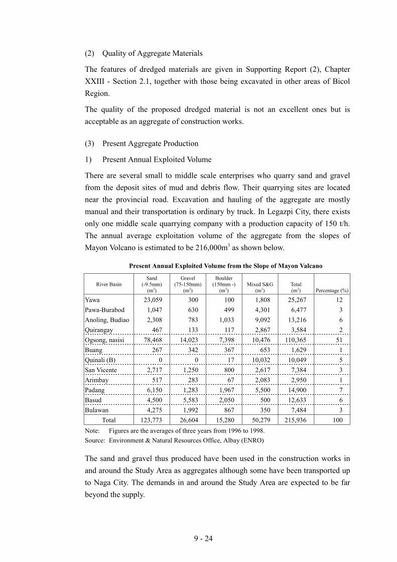
There are several small to middle scale enterprises who quarry sand and gravelfrom the deposit sites of mud and debris flow. Their quarrying sites are locatednear the provincial road. Excavation and hauling of the aggregate are mostlymanual and their transportation is ordinary by truck. In Legazpi City, there existsonly one middle scale quarrying company with a production capacity of 150 t/h.The annual average exploitation volume of the aggregate from the slopes ofMayon Volcano is estimated to be 216,000m3 as shown below.
Present Annual Exploited Volume from the Slope of Mayon Valcano
River BasinSand
(-9.5mm)(m3)
Gravel(75-150mm)
(m3)
Boulder(150mm -)
(m3)Mixed S&G
(m3)Total(m3) Percentage (%)
Yawa 23,059 300 100 1,808 25,267 12Pawa-Burabod 1,047 630 499 4,301 6,477 3Anoling, Budiao 2,308 783 1,033 9,092 13,216 6Quirangay 467 133 117 2,867 3,584 2Ogsong, nasisi 78,468 14,023 7,398 10,476 110,365 51Buang 267 342 367 653 1,629 1Quinali (B) 0 0 17 10,032 10,049 5San Vicente 2,717 1,250 800 2,617 7,384 3Arimbay 517 283 67 2,083 2,950 1Padang 6,150 1,283 1,967 5,500 14,900 7Basud 4,500 5,583 2,050 500 12,633 6Bulawan 4,275 1,992 867 350 7,484 3
Total 123,773 26,604 15,280 50,279 215,936 100Note: Figures are the averages of three years from 1996 to 1998.Source: Environment & Natural Resources Office, Albay (ENRO)
The sand and gravel thus produced have been used in the construction works inand around the Study Area as aggregates although some have been transported upto Naga City. The demands in and around the Study Area are expected to be farbeyond the supply.
9 - 25
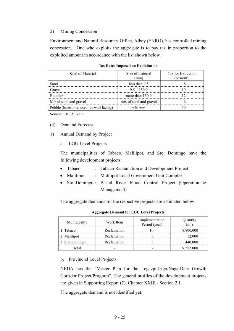
2) Mining Concession
Environment and Natural Resources Office, Albay (ENRO), has controlled miningconcession. One who exploits the aggregate is to pay tax in proportion to theexploited amount in accordance with the list shown below.
Tax Rates Imposed on Exploitation
Kind of Material Size of material(mm)
Tax for Extraction(peso/m3)
Sand less than 9.5 8Gravel 9.5 – 150.0 19Boulder more than 150.0 12Mixed sand and gravel mix of sand and gravel 6Pebble (limestone, used for wall facing) "30 mm 50
Source: JICA Team
(4) Demand Forecast
1) Annual Demand by Project
a. LGU Level Projects
The municipalities of Tabaco, Malilipot, and Sto. Domingo have thefollowing development projects:
! Tabaco : Tabaco Reclamation and Development Project! Malilipot : Malilipot Local Government Unit Complex! Sto. Domingo : Basud River Flood Control Project (Operation &
Management)
The aggregate demands for the respective projects are estimated below:
Aggregate Demand for LGU Level Projects
Municipality Work Item ImplementationPeriod (year)
Quantity(m3)
1. Tabaco Reclamation 10 8,800,0002. Malilipot Reclamation 5 12,0003. Sto. domingo Reclamation 5 440,000
Total - - 9,252,000
b. Provincial Level Projects
NEDA has the “Master Plan for the Legazpi-Iriga-Naga-Daet GrowthCorridor Project/Program”. The general profiles of the development projectsare given in Supporting Report (2), Chapter XXIII - Section 2.1.
The aggregate demand is not identified yet.
9 - 26
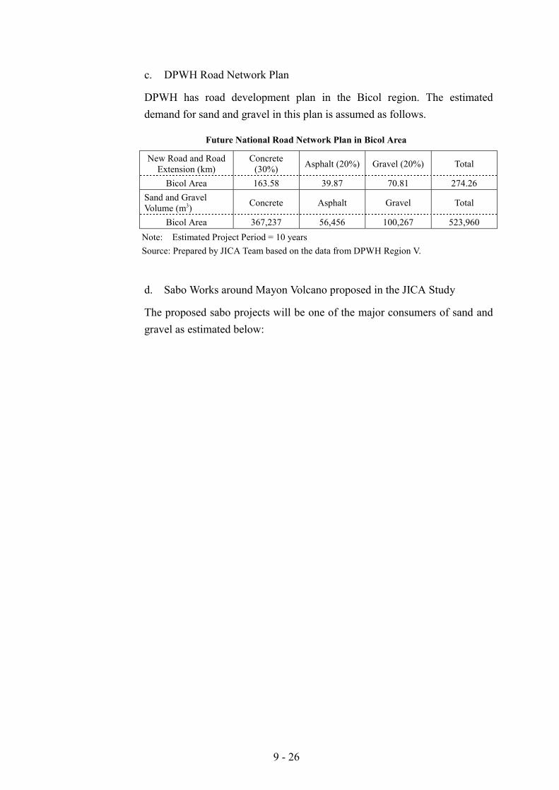
c. DPWH Road Network Plan
DPWH has road development plan in the Bicol region. The estimateddemand for sand and gravel in this plan is assumed as follows.
Future National Road Network Plan in Bicol Area
New Road and RoadExtension (km)
Concrete(30%) Asphalt (20%) Gravel (20%) Total
Bicol Area 163.58 39.87 70.81 274.26Sand and GravelVolume (m3) Concrete Asphalt Gravel Total
Bicol Area 367,237 56,456 100,267 523,960Note: Estimated Project Period = 10 yearsSource: Prepared by JICA Team based on the data from DPWH Region V.
d. Sabo Works around Mayon Volcano proposed in the JICA Study
The proposed sabo projects will be one of the major consumers of sand andgravel as estimated below:
9 - 27
Aggregate Volume for the Sabo Works around Mayon
Sabo Dam Dike
River Basin Length(m)
Volume(m3)
Length(m)
Volume(m3)
TotalAggregateVolume tobe Needed
(m3)Pawa-Burabod 450 30,420 600 (A)
4,075 (B)375 (C)
18,456214,508
22,496
285,880
Anoling, Budiao 650 43,940 1,725 (A)1,800 (B)
53,06194,752
191,753
Quirangay 350 23,660 950 (A)700 (B)
29,22236,848
89,730
Masarawag 100 6,760 1,250 (A)2,050 (B)1,050 (C)
38,450107,912
62,990
216,112
Buang 0 0 1,150 (B) 60,536 60,536San Vicente 700 47,320 1,950 (A)
4,250 (B)59,982
223,720331,022
Padang 350 23,660 3,950 (A)600 (B)
121,50231,584
176,746
Buang 0 0 1,150 (B) 609,536 60,536Basud 350 23,660 2,500 (A)
500 (B)2,000 (C)
76,90026,320
119,980
246,860
Bulawan 0 0 1,350 (B)3,050 (C)
71,064182,970
254,034
Total 2,950 199,420 35,875 1,653,253 1,852,673
The unit sand and gravel volumes for each of dikes and sabo dams are asfollows:
! Type A : 30.76 m3/m! Type A : 30.76 m3/m! Type A : 30.76 m3/m! Sabo Dam : 67.60 m3/m
2) Total Annual Demand Forecast
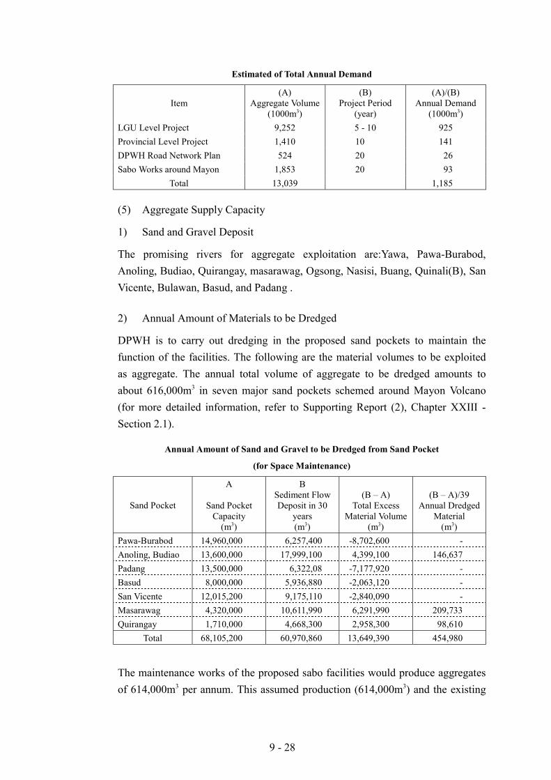
The total aggregate demand in the Study Area is estimated at around 1.19 millionm3 per year as summarized below:
9 - 28
Estimated of Total Annual Demand
Item(A)
Aggregate Volume(1000m3)
(B)Project Period
(year)
(A)/(B)Annual Demand
(1000m3)LGU Level Project 9,252 5 - 10 925Provincial Level Project 1,410 10 141DPWH Road Network Plan 524 20 26Sabo Works around Mayon 1,853 20 93
Total 13,039 1,185
(5) Aggregate Supply Capacity
1) Sand and Gravel Deposit
The promising rivers for aggregate exploitation are:Yawa, Pawa-Burabod,Anoling, Budiao, Quirangay, masarawag, Ogsong, Nasisi, Buang, Quinali(B), SanVicente, Bulawan, Basud, and Padang .
2) Annual Amount of Materials to be Dredged
DPWH is to carry out dredging in the proposed sand pockets to maintain thefunction of the facilities. The following are the material volumes to be exploitedas aggregate. The annual total volume of aggregate to be dredged amounts toabout 616,000m3 in seven major sand pockets schemed around Mayon Volcano(for more detailed information, refer to Supporting Report (2), Chapter XXIII -Section 2.1).
Annual Amount of Sand and Gravel to be Dredged from Sand Pocket
(for Space Maintenance)
Sand Pocket
A
Sand PocketCapacity
(m3)
BSediment FlowDeposit in 30
years(m3)
(B – A)Total Excess
Material Volume(m3)
(B – A)/39Annual Dredged
Material(m3)
Pawa-Burabod 14,960,000 6,257,400 -8,702,600 -Anoling, Budiao 13,600,000 17,999,100 4,399,100 146,637Padang 13,500,000 6,322,08 -7,177,920 -Basud 8,000,000 5,936,880 -2,063,120 -San Vicente 12,015,200 9,175,110 -2,840,090 -Masarawag 4,320,000 10,611,990 6,291,990 209,733Quirangay 1,710,000 4,668,300 2,958,300 98,610
Total 68,105,200 60,970,860 13,649,390 454,980
The maintenance works of the proposed sabo facilities would produce aggregatesof 614,000m3 per annum. This assumed production (614,000m3) and the existing
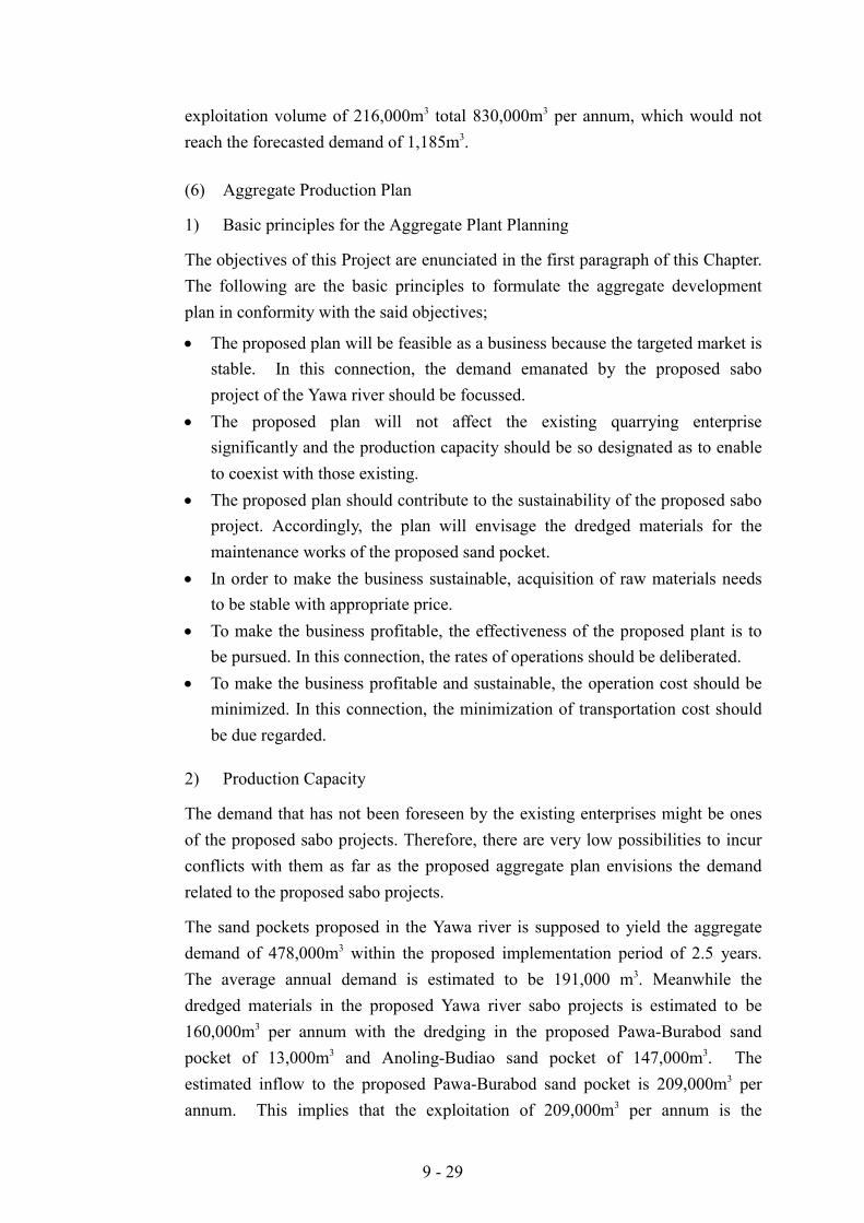
9 - 29
exploitation volume of 216,000m3 total 830,000m3 per annum, which would notreach the forecasted demand of 1,185m3.
(6) Aggregate Production Plan
1) Basic principles for the Aggregate Plant Planning
The objectives of this Project are enunciated in the first paragraph of this Chapter.The following are the basic principles to formulate the aggregate developmentplan in conformity with the said objectives;
! The proposed plan will be feasible as a business because the targeted market isstable. In this connection, the demand emanated by the proposed saboproject of the Yawa river should be focussed.
! The proposed plan will not affect the existing quarrying enterprisesignificantly and the production capacity should be so designated as to enableto coexist with those existing.
! The proposed plan should contribute to the sustainability of the proposed saboproject. Accordingly, the plan will envisage the dredged materials for themaintenance works of the proposed sand pocket.
! In order to make the business sustainable, acquisition of raw materials needsto be stable with appropriate price.
! To make the business profitable, the effectiveness of the proposed plant is tobe pursued. In this connection, the rates of operations should be deliberated.
! To make the business profitable and sustainable, the operation cost should beminimized. In this connection, the minimization of transportation cost shouldbe due regarded.
2) Production Capacity
The demand that has not been foreseen by the existing enterprises might be onesof the proposed sabo projects. Therefore, there are very low possibilities to incurconflicts with them as far as the proposed aggregate plan envisions the demandrelated to the proposed sabo projects.
The sand pockets proposed in the Yawa river is supposed to yield the aggregatedemand of 478,000m3 within the proposed implementation period of 2.5 years.The average annual demand is estimated to be 191,000 m3. Meanwhile thedredged materials in the proposed Yawa river sabo projects is estimated to be160,000m3 per annum with the dredging in the proposed Pawa-Burabod sandpocket of 13,000m3 and Anoling-Budiao sand pocket of 147,000m3. Theestimated inflow to the proposed Pawa-Burabod sand pocket is 209,000m3 perannum. This implies that the exploitation of 209,000m3 per annum is the
9 - 30
harmless volume for the sand pocket. Consequently the production capacity of356,000m3 is adopted for the aggregate plant. This amount will suffice the demandof the Yawa sabo projects of 191,000m3 and consume all the dredged materials forthe maintenance. Moreover, the amount will extend the life of the proposed Pawa-Burabod sand pocket.
The production capacity of the proposed plant is 1,480m3 per day assuming 20working days per month. The hourly production capacity is 230m3 assuming 6.5operation hours a day.
3) Aggregate Plant Component
Main equipment for aggregate plant include crusher plant, dump truck, pay loader,backhoe, and bulldozer. In addition to the equipment, office, laboratory,warehouse, plant yard, and stockyard for raw material and products are necessary.
In order to enjoy scale factor, all the production works are concentrated to oneplant. In this connection, barangay Mabinit is proposed as the aggregate plantwith a capacity of 250 m3 per hour since the substantial raw materials are to beexploited from the Pawa-Burabod sand pocket. The materials from Anoling-Budiao sand pocket will be conveyed to the plant site through the existingprovincial road. The necessary plant yard is estimated to be 4.0 ha including 20ha of stockpile yard. The specificaitons of equipment are as follows:
! Crashing plant x 1 250 m/h! Pay loader x 1 2.5 m! Backhoe x 1 1.2 m! Bulldozer x 1 22 t with ripper! Dump truck x 10 11 t! Generator x 3 250 Kva
4) Cost Items
The cost requisite to the proposed aggregate plant consists of investment andrunning costs. Investment cost comprises the costs for equipment, construction ofoffice and yard preparation. Running cost includes the costs for manpower, OMRof equipment, office and yard as well as taxes.
a. Investment Cost
The investment cost is estimated at PHP81.4 million as broken down below:
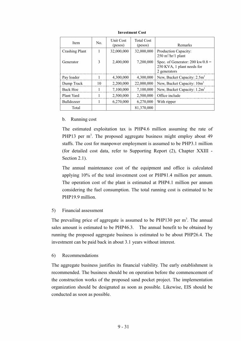
9 - 31
Investment Cost
Item No. Unit Cost(pesos)
Total Cost(pesos) Remarks
Crashing Plant 1 32,000,000 32,000,000 Production Capacity:250 m3/hr/1 plant
Generator 3 2,400,000 7,200,000 Spec. of Generator: 200 kw/0.8 =250 KVA, 1 plant needs for2 generators
Pay loader 1 4,300,000 4,300,000 New, Bucket Capacity: 2.5m3
Dump Track 10 2,200,000 22,000,000 New, Bucket Capacity: 10m3
Back Hoe 1 7,100,000 7,100,000 New, Bucket Capacity: 1.2m3
Plant Yard 1 2,500,000 2,500,000 Office includeBulldozeer 1 6,270,000 6,270,000 With ripper
Total 81,370,000
b. Running cost
The estimated exploitation tax is PHP4.6 million assuming the rate ofPHP13 per m3. The proposed aggregate business might employ about 49staffs. The cost for manpower employment is assumed to be PHP3.1 million(for detailed cost data, refer to Supporting Report (2), Chapter XXIII -Section 2.1).
The annual maintenance cost of the equipment and office is calculatedapplying 10% of the total investment cost or PHP81.4 million per annum.The operation cost of the plant is estimated at PHP4.1 million per annumconsidering the fuel consumption. The total running cost is estimated to bePHP19.9 million.
5) Financial assessment
The prevailing price of aggregate is assumed to be PHP130 per m3. The annualsales amount is estimated to be PHP46.3. The annual benefit to be obtained byrunning the proposed aggregate business is estimated to be about PHP26.4. Theinvestment can be paid back in about 3.1 years without interest.
6) Recommendations
The aggregate business justifies its financial viability. The early establishment isrecommended. The business should be on operation before the commencement ofthe construction works of the proposed sand pocket project. The implementationorganization should be designated as soon as possible. Likewise, EIS should beconducted as soon as possible.
9 - 32
The facilities such as water supply, drainage, electricity, communication systemand road should be so developed as to contribute for the benefit of the relatedbarangay.
9.3.2 Mineral Water Development Project
(1) Introduction
The mineral water development project aims at contributing for the developmentof the regional economy through introducing a sustainable industry in the mosteconomically depressed region in the country.
The estimated mean annual precipitation depth in the Study Area is 3,000mmaccording to the recorded data observed in Legazpi. The gauging station is locatedat lower elevation than 100 m. The mountain slopes with higher elevations mighthave received much more rainfall. In addition, the estimated average annual rainydays of 210 days distribute through out the year almost evenly. Meanwhile, apart of received rain water intrude deep into the soil and become groundwaterwith high quality by the purification effect and mineral contents of volcanicdeposit.
In the circumstances, a mineral water development project at the foot of MayonVolcano is recommended.
(2) Present Conditions
Test exploitation of water has been done in and around Carayucay, a barangay ofMunicipality of Santo Domingo, to examine the quality and quantity of theresources preliminarily.
(3) Quality of ground water
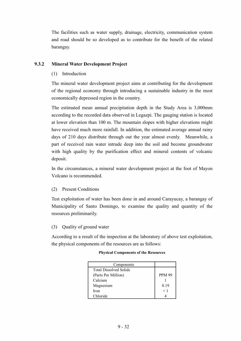
According to a result of the inspection at the laboratory of above test exploitation,the physical components of the resources are as follows:
Physical Components of the Resources
ComponentsTotal Dissolved Solids(Parts Per Million) PPM 99Calcium 1Magnesium 0.19Iron < 1Chloride 4
9 - 33
(4) Quantity of ground water
Based on the estimated mean annual precipitation (3,000mm), the quantity ofgroundwater is estimated in the following manner.
1) It is assumed that 1,000mm/year of received rain water will intrude deep intothe soil.
2) It is assumed that 20% of this 1,000mm/year can be pumped from a well, andthe remaining water will pour into the sea.
3) As a result these assumptions, the amount of 0.2m/year/m2 equivalent to2,000m3/year/ha might be exploited.
(5) Demand for Domestic Water
According to the JICA study report titled "Natural Water Resources ManagementStudy, 1997", Metro Manila, Metro Sebu, and Baguio City are identified as asignificant water critical areas. It means that water supply development is aemergency issue for the areas. Thus, potable water also has a great demand forthe areas. Meanwhile, at present many kinds of bottled mineral water are selling inthe local market. The market prices of bottled mineral water are about30 PHP/liter for local products and more than 50 PHP/liter for imported ones.The market of bottled mineral water is expected to be further expanded.
(6) Market Aspect
The operation of production will be carried out initially to sell the mineral water tothe places lacking in water in the country, and then may be expanded to export itto foreign countries.
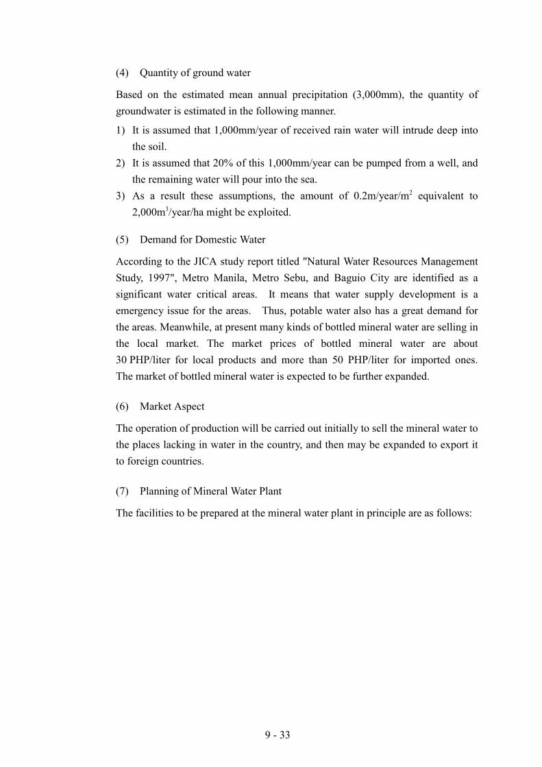
(7) Planning of Mineral Water Plant
The facilities to be prepared at the mineral water plant in principle are as follows:
9 - 34
Facilities in the Mineral Water Plant
1. Exploitation facilityWell and pumpIntakeUtility
2. Conveyance facilityWater conveyance channel and pipeUtility
3. Plant and laboratoryPurification plantLaboratory
4. Building and civil worksOffice, factory and laboratory buildingsAccess roadYard
5. Storage and loading facilityStorage tankLoading facilities for bulk and bottled waterStorage yardUtility
Facilities
On the assumption that concession area is 500 ha in the Santo Domingo Area, theproduction capacity is estimated at 1.0 million m3/year on the basis of theestimated quantity of exploitable groundwater (2,000m3/year/ha).
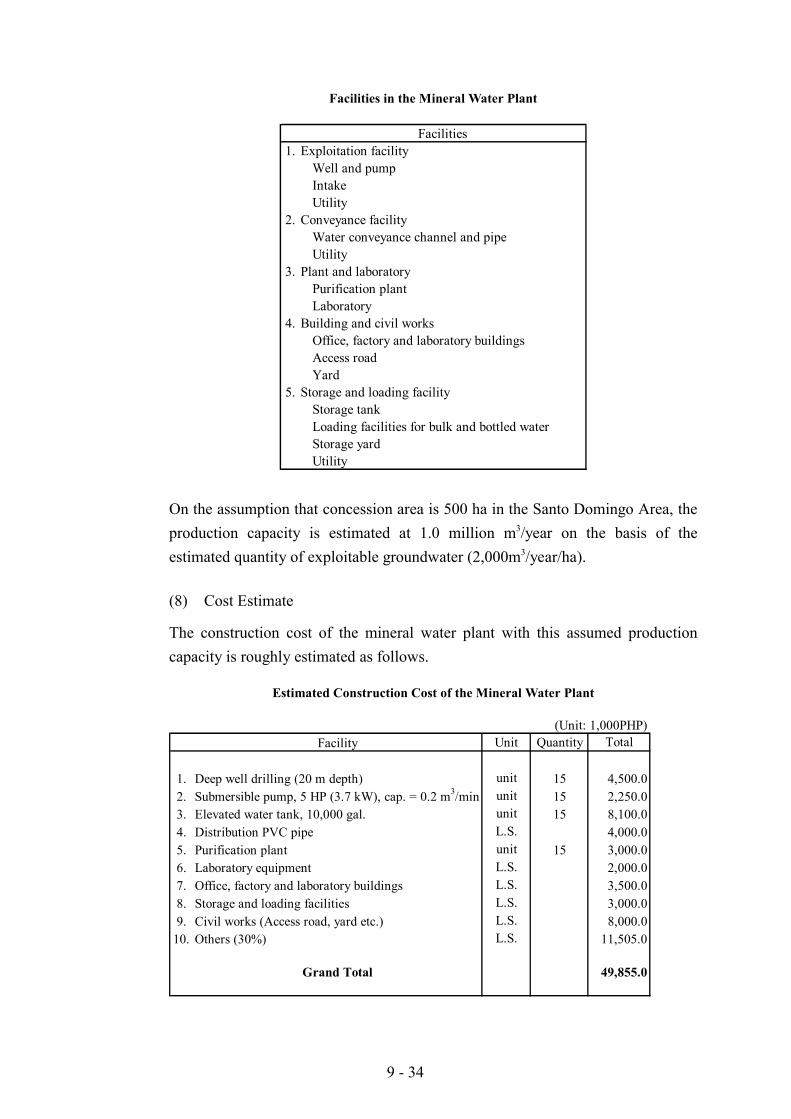
(8) Cost Estimate
The construction cost of the mineral water plant with this assumed productioncapacity is roughly estimated as follows.
Estimated Construction Cost of the Mineral Water Plant
(Unit: 1,000PHP)Facility Unit Quantity Total
1. Deep well drilling (20 m depth) unit 15 4,500.02. Submersible pump, 5 HP (3.7 kW), cap. = 0.2 m3/min unit 15 2,250.03. Elevated water tank, 10,000 gal. unit 15 8,100.04. Distribution PVC pipe L.S. 4,000.05. Purification plant unit 15 3,000.06. Laboratory equipment L.S. 2,000.07. Office, factory and laboratory buildings L.S. 3,500.08. Storage and loading facilities L.S. 3,000.09. Civil works (Access road, yard etc.) L.S. 8,000.0
10. Others (30%) L.S. 11,505.0
Grand Total 49,855.0
9 - 35
It should be noted that this construction cost does not include the cost of bottlingfacility, transportation, administration and engineering services, since a bulkbusiness is possible and the works of bottling and transportation can be contractedseparately.
(9) Financial Assessment
The prevailing price of mineral water in bulk is assumed at 30 PHP per m3. Theannual sales amount is estimated at 30,000,000 PHP.
The total annual running cost is assumed at about 19,900,000 PHP equivalent to40% of construction cost. Thus, the annual benefit to be obtained by running theproposed mineral water business is estimated at about 10,100,000 PHP. Theinvestment can be paid back in about 4.9 years without interest.
9.3.3 Productivity Enhancement Programs in the Protected Area
(1) Present Situation and Scenario for the Project Area
The land around Mayon Volcano is very fertile, but agricultural production hasremained very low. The present area to be protected by the project totals 2,339hectares and about 1,850.34 hectares is currently being used for agriculturalproduction; broken down as coconut lands, 811.068 hectares, non-irrigated paddy,310.746 hectares, and irrigated paddy, 728.526 hectares (JICA Land Use Map,1999).
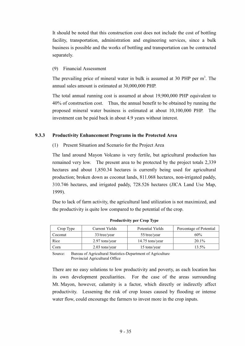
Due to lack of farm activity, the agricultural land utilization is not maximized, andthe productivity is quite low compared to the potential of the crop.
Productivity per Crop Type
Crop Type Current Yields Potential Yields Percentage of PotentialCoconut 33/tree/year 55/tree/year 60%Rice 2.97 tons/year 14.75 tons/year 20.1%Corn 2.03 tons/year 15 tons/year 13.5%Source: Bureau of Agricultural Statistics-Department of Agriculture
Provincial Agricultural Office
There are no easy solutions to low productivity and poverty, as each location hasits own development peculiarities. For the case of the areas surroundingMt. Mayon, however, calamity is a factor, which directly or indirectly affectproductivity. Lessening the risk of crop losses caused by flooding or intensewater flow, could encourage the farmers to invest more in the crop inputs.
9 - 36
For the purpose of this Study, crop productivity is envisioned to be raised to atleast 65% the potential for rice, and 40% for corn.
(2) Cause and Effect of Low Productivity in the Protected Area
The land area around Mayon is one of the best areas for agro-industrialdevelopment in the province. Siltation from the slopes of the mountain keeps thesoil fertile and the constant supply of fresh water is suitable for agro-industrialactivities. The full potential of the land is not, however, taken advantage of bythe farmers because of fear of calamities, lack of technical knowledge, and lack ofsufficient capital to invest into the farm.
Even with these excellent conditions, the productivity of the farmers in Albay hasbeen generally low. The main reasons for the low farm productivity of the farmersin the project area, are ignorance, lack of capital to invest in farming due topoverty, and calamities due to adverse weather conditions. The very lowproductivity due to poverty is also the cause of the increasing poverty situation inthe area. The following table shows the household expenditure data in the ProjectArea.
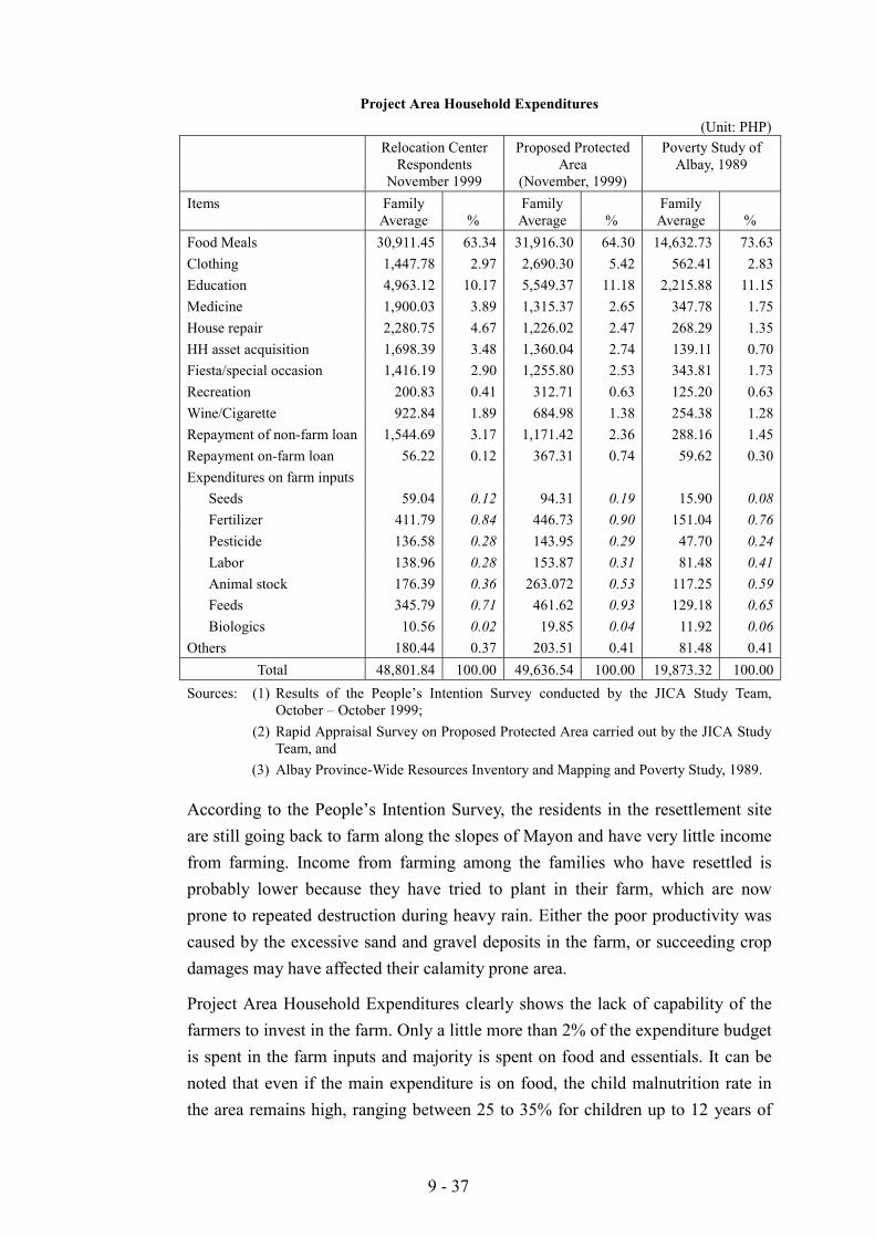
9 - 37
Project Area Household Expenditures(Unit: PHP)
Relocation CenterRespondents
November 1999
Proposed ProtectedArea
(November, 1999)
Poverty Study ofAlbay, 1989
Items FamilyAverage %
FamilyAverage %
FamilyAverage %
Food Meals 30,911.45 63.34 31,916.30 64.30 14,632.73 73.63Clothing 1,447.78 2.97 2,690.30 5.42 562.41 2.83Education 4,963.12 10.17 5,549.37 11.18 2,215.88 11.15Medicine 1,900.03 3.89 1,315.37 2.65 347.78 1.75House repair 2,280.75 4.67 1,226.02 2.47 268.29 1.35HH asset acquisition 1,698.39 3.48 1,360.04 2.74 139.11 0.70Fiesta/special occasion 1,416.19 2.90 1,255.80 2.53 343.81 1.73Recreation 200.83 0.41 312.71 0.63 125.20 0.63Wine/Cigarette 922.84 1.89 684.98 1.38 254.38 1.28Repayment of non-farm loan 1,544.69 3.17 1,171.42 2.36 288.16 1.45Repayment on-farm loan 56.22 0.12 367.31 0.74 59.62 0.30Expenditures on farm inputs
Seeds 59.04 0.12 94.31 0.19 15.90 0.08Fertilizer 411.79 0.84 446.73 0.90 151.04 0.76Pesticide 136.58 0.28 143.95 0.29 47.70 0.24Labor 138.96 0.28 153.87 0.31 81.48 0.41Animal stock 176.39 0.36 263.072 0.53 117.25 0.59Feeds 345.79 0.71 461.62 0.93 129.18 0.65Biologics 10.56 0.02 19.85 0.04 11.92 0.06
Others 180.44 0.37 203.51 0.41 81.48 0.41Total 48,801.84 100.00 49,636.54 100.00 19,873.32 100.00
Sources: (1) Results of the People’s Intention Survey conducted by the JICA Study Team,October – October 1999;
(2) Rapid Appraisal Survey on Proposed Protected Area carried out by the JICA StudyTeam, and
(3) Albay Province-Wide Resources Inventory and Mapping and Poverty Study, 1989.
According to the People’s Intention Survey, the residents in the resettlement siteare still going back to farm along the slopes of Mayon and have very little incomefrom farming. Income from farming among the families who have resettled isprobably lower because they have tried to plant in their farm, which are nowprone to repeated destruction during heavy rain. Either the poor productivity wascaused by the excessive sand and gravel deposits in the farm, or succeeding cropdamages may have affected their calamity prone area.
Project Area Household Expenditures clearly shows the lack of capability of thefarmers to invest in the farm. Only a little more than 2% of the expenditure budgetis spent in the farm inputs and majority is spent on food and essentials. It can benoted that even if the main expenditure is on food, the child malnutrition rate inthe area remains high, ranging between 25 to 35% for children up to 12 years of
9 - 38
age (DSWD, National Nutrition Council Report 1997). Any additional investment,therefore, in the farm would mean greater sacrifice on the daily life of the farmer,especially if the crop becomes a failure. The amount of investment they areputting therefore, is only less than 15% of the required. Almost all their incomeis spent for basic necessities. There is no room for more investment into farmingexcept their own labor.
It can be observed from the above table: Project Area Household Expendituresthat the farmers in the relocation centers had a deficit year during the survey.They spent PHP6,727.17 more than they earned for the year. They particularlyexperienced a loss in their agricultural investment where they invested on theaverage of PHP1,279.11 and only harvested PHP1,242.32 worth of products fromthe farm. It may have been caused by damage due to weather.
A poverty mapping survey for Albay commissioned by NEDA shows thatconsiderable number of rural area residents belong to the lower income groupwhich barely makes ends meet to be able to survive.
According to the table given in Supporting Report (2), Chapter XXIII (Section2.3), about 78.8% of the farmers belong to the low income level which can notmake the necessary farm investment. It can, therefore, be concluded that almost78.8% of the farms in the area are being farmed by people who cannot afford tomake the necessary investments in the farm. As such, most of the rural farmershave very low income that their capability to invest in a crop, especially if there isrisk of loss, is very low.
There is also the problem on lack of technical knowledge of the farmers. Out of180 farmers surveyed, none said that they are actively using organic fertilizers(JICA Survey). This is evidenced by the lack of nitrogen content and organicmatter content of the soil in the area.
Because of this, agricultural production, in spite of the presence of the necessarytechnologies, has remained low in the past 10 years, approximately 2 tons for corn,and 3.5 to 4.0 tons for rice (for more detailed data, refer to Supporting Report (2),Chapter XXIII - Section 2.3).
(3) Topographic Condition, soil Fertility, and Present Land Use of Project Area
1) Topography
The project area is characterized by varying slopes from the six-kilometer radiusto the Yawa River where much of the water run-off from the slopes drain. Muchof the paddy fields and vegetable farms are located on the gentle slopes with 1 to
9 - 39
5% inclinations. Non-irrigated areas are located mostly on 60 to 110m elevationwith gentle slopes up to 7%. Much of the coconut lands are above 120melevation and with slopes from 7 to 10%.
Although the slope is still suitable for agriculture, water and silt retention in slopesis an essential part of any agricultural activity in the project area. Unfortunately,many of the farmers are lowland farmers trying to practice lowland agriculture onthe slopes.
2) Soil Fertility
The upper area beyond 150m elevation is generally composed of Mayon GravellyLoam, most of the areas at 50 to 150m elevation are of the Legazpi Fine SandyLoam (Stony Phase) type and below the 50m elevation is Legazpi Fine SandyLoam.
The soil is very suitable for agriculture especially for crops other than rice. Theloose characteristics of the soil allow good water drainage from the surface whileallowing for sufficient air in the soil for root growth. The nitrogen content is lowat 0.15 to 0.3% and calcium at 3 to 15 ppm. The soil pH is mostly alkaline andtherefore very responsive to fertilization.
The rice lands have formed a natural hard pan of clay and silt for water retention.Surveys made by the JICA Study Team, however, have indicated the lack of useby farmers of both organic and inorganic fertilizers, depleting the nutritionalcontents of the soil and thereby decreasing yields.
3) Present and Prospective Land Use
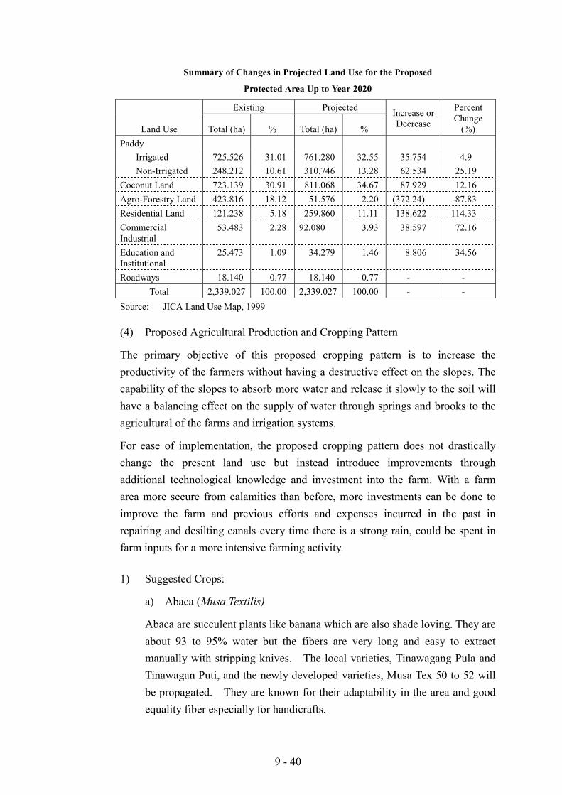
Many of the farmers cultivating the slopes of Mayon have their origins in thelowlands and are practicing lowland methods of farming. As shown on previoustables, these practices are often not very productive and promote further erosionand decrease in soil fertility. The existing and prospective land uses aresummarized in the following table (for detailed information, refer to tables inSupporting Report (2), Chapter XXIII - Section 2.3).
9 - 40
Summary of Changes in Projected Land Use for the Proposed
Protected Area Up to Year 2020
Existing Projected
Land Use Total (ha) % Total (ha) %
Increase orDecrease
PercentChange
(%)Paddy
Irrigated 725.526 31.01 761.280 32.55 35.754 4.9Non-Irrigated 248.212 10.61 310.746 13.28 62.534 25.19
Coconut Land 723.139 30.91 811.068 34.67 87.929 12.16Agro-Forestry Land 423.816 18.12 51.576 2.20 (372.24) -87.83Residential Land 121.238 5.18 259.860 11.11 138.622 114.33CommercialIndustrial
53.483 2.28 92,080 3.93 38.597 72.16
Education andInstitutional
25.473 1.09 34.279 1.46 8.806 34.56
Roadways 18.140 0.77 18.140 0.77 - -Total 2,339.027 100.00 2,339.027 100.00 - -
Source: JICA Land Use Map, 1999
(4) Proposed Agricultural Production and Cropping Pattern
The primary objective of this proposed cropping pattern is to increase theproductivity of the farmers without having a destructive effect on the slopes. Thecapability of the slopes to absorb more water and release it slowly to the soil willhave a balancing effect on the supply of water through springs and brooks to theagricultural of the farms and irrigation systems.
For ease of implementation, the proposed cropping pattern does not drasticallychange the present land use but instead introduce improvements throughadditional technological knowledge and investment into the farm. With a farmarea more secure from calamities than before, more investments can be done toimprove the farm and previous efforts and expenses incurred in the past inrepairing and desilting canals every time there is a strong rain, could be spent infarm inputs for a more intensive farming activity.
1) Suggested Crops:
a) Abaca (Musa Textilis)
Abaca are succulent plants like banana which are also shade loving. They areabout 93 to 95% water but the fibers are very long and easy to extractmanually with stripping knives. The local varieties, Tinawagang Pula andTinawagan Puti, and the newly developed varieties, Musa Tex 50 to 52 willbe propagated. They are known for their adaptability in the area and goodequality fiber especially for handicrafts.
9 - 41
b) Pilinut (Canarium ovatum)
Pilinuts are big trees with almond shaped fruits about 5 cm in length. Itspulp is rich in protein and its kernel is a delicacy in the Philippines. It isonly grown in the Philippines and 82% of the country’s supply comes fromthe Bicol Region. It has very great export potential. The local varietieswill be used for propagation.
c) Moras (Vetiver zesanoides)
Moras or Vetiver is now a very well known grass in the world for itseffectiveness against erosion. Its roots are very extensive and long and itsstem can withstand strong runoff. Planted as line hedges, it makes one ofthe most effective erosion control methods practiced by bio-engineers today.It has an aromatic scent and its oil can be extracted for mixing withpesticides, detergents, etc.
d) Lemon Grass (Paja de meca, and Citronella)
These are aromatic grasses which can easily grow in sandy soils and aredrought resistant. They are also known as spices and the oil is also beingextracted for mixture for detergents and other products.
e) Rice (Oryza sativa)
The varieties that shall be recommended the project site are PSB-RC18,RSB-RC14 which have been developed at Philrice at Munoz, Nueva Ecijaand are found suitable for the purpose of intensive cropping system becauseof its shorter maturity duration.
f) Corn (Zea mays)
The variety of corn that will be used here will be the open pollinatedvarieties from the Institute of Plant Breeding so that the farmers can growtheir own seeds.
g) Mungbean (Vigna radiata)
Although the farmers along the slopes of Mayon produces a wide variety ofvegetables these two vegetables are used as the basis for economiccomputation for feasibility of producing vegetables in the area.
9 - 42
h) Agoho (Casuarina equisetifolia)
This is a very sturdy perennial tree which propagates through seeds whichfall on the ground and are carried away by rainwater along the slopes ofMayon. It grows very well in the sand and can become a large tree.People in Mayon use these trees as house building materials and forfirewood.
2) The utilization of Uncultivated and Gravel and Sand Covered Areas
Especially if the dikes are constructed, much of the 423 ha in the protected areasmade idle by deposition of gravel and sand from the volcano can be graduallyrecovered.
Even if the sand and gravel surface that accumulated in the surface is carried awayby water or taken through gravel and sand business, it will still cost the landowner an average of PHP10 per square meter for irrigated rice paddy and PHP2.5per square meter for non-irrigated land to rehabilitate the area. It is estimatedthat 372 ha will be reclaimed in this manner in case the protection dikes are built.
These exposed land areas are still very prone for further erosion. It is thereforeadvisable that they be covered with vegetation especially if they are near gullies oris susceptible to flash flooding.
To cover these areas with the erosion control plants, it is necessary to establishnurseries to propagate planting materials. A distilling plant should be introducedin the project area to support this program. It is also necessary that technicalassistance be provided to the interested farmers.
3) The Coconut Area
With an area of 723 ha, the coconut area is the quite large, but still very littleutilized. The coconut trees are planted only as single crop and no fertilization isapplied. As a result, the coconuts in the area only produces 33 nuts per tree,which is low compared to the potential of 55 nuts per tree. For the project area,they are dominant in areas with elevations of more than 100m. To maximize thecoconut area, the project has identified areas where they may raise abaca, coffee,pilinut, or grass under the coconut tree.
In order to accelerate the development of coconut farms, it is necessary that thefollowing activities be undertaken:
9 - 43
a. Organization of the farmers into Cooperativesb. Training programs on technologies on coffee, abaca, pilinut, and
aromatic grassesc. Establishment of nurseries for propagation of planting materialsd. Financing arrangements with Land bank or any financial institutions
4) The Rice Farms
The un-irrigated rice farms can be assisted to grow three times a year by plantingrice-legumes-corn. This pattern would be best especially for upper areas, whichhave been newly converted to rice.
Areas where irrigation is sufficient will be advised to plant legumes as its thirdcrop to reduce the insect pests and enrich the land with natural nitrogen.
To improve farm productivity in the project area, it is advised to organize thefarmers into cooperatives so that they can have the financing access and trainingprogram development.
(5) Integration of Medium/Large Scale Animal Production
At present, the province produces only 470.08 tons of chicken meat or only 11%of the required 4,289.99 tons for local consumption. The current demand forpoultry eggs is 2,806.64 tons, and the production is only 1,162.84 tons or 41% ofthe demand. The consumption of pork in the province is estimated to be8,740 tons while the available supply is only 5,004.33 tons.
The lack of financing and facilities of the small farmers and animal raisers leads toinefficient methods of farming, which eventually make animal productionexpensive in the province. Small corn farmers, since they need moneyimmediately and have no storage facilities, sell their corn at very cheap pricesimmediately after harvest.
The weakness of the individual and unorganized farmers makes the existence ofthe rich traders necessary. The traders generally provide the following serviceswhich otherwise no one provides:
1) Financing
Traders often lend money to the farmers even at high rates. Farmers do not haveready access to institutional lending. They have to resort to non-formal lendingarrangements which eventually become expensive for them.
9 - 44
2) Transportation
The traders have transport facilities which the farmers do not have.
3) Storage
The farmers can only store very limited amount of grains in their very small house.They are, therefore, forced to sell their produce even at low prices because theymight spoil.
4) Managerial Expertise
The traders provide managerial skills to keep large volumes of transactions goingwhich are otherwise unmanageable for ordinary farmers.
To be able to produce more efficiently, it is necessary for the farmers to integratetheir production, and lower the transfer costs from one hand to the other. Thefarmers, however, can eliminate the middlemen or the traders if they are able toget financing, have their own transportation facilities, have their own warehouses,feed mill, and large growing facilities. Since the present farmers could notaccomplish these on their own, it is quite obvious that a certain level ofgovernment intervention is necessary along these lines. The farmers would needexternal assistance on financing, technical knowledge, managerial and marketingskill development.
(6) Total Projected Yearly Production
The projected total population of Daraga and Legazpi by year 2020 will be401,586. The volume of rice production which would be 9,136 tons will coverthe rice requirement for 90,009 people at an average of 101.5 kg/capitaconsumption, which is around 22.4% of the combined population of Daraga andLegazpi.
(7) Preliminary Economic Assessment
1) Incremental Benefit to Coconut Farmers
Through the project, coconut farmers will enjoy higher income due tointercropping and processing of essential oils. The project makes it possible forthe coconut farmers to intensify production in the coconut lands throughintercropping with coffee, pilinut, and abaca.
From the intercrops, the farmers stand to have an average increase of P32,234 inincome per hectare per year. Fertilization will lead to an increase of production by30% or 1,000 nuts per year per hectare. The coconut farmers can also be members

9 - 45
of the cooperative which will engage in abaca and coffee trading, and essential oilproduction. Increased fertility due to application of fertilizers to the intercropwill also result in a better coconut harvest leading to an additional income ofP25,000 per year per hectare.
2) Incremental Benefits to Irrigated Land Farmers
The rice farmer stands to benefit the most from the project. Firstly, he will notspend so much effort for the constant repair of his farm and will experience lessloss due to calamities. The farmer could therefore be encouraged to investmoney and efforts to improve his own farm.
More controlled water flow means more stable water supply, which is quiteimportant for rice farmers. The result of additional investment by the farmer willbe evident in the increase in farm income per. It is hoped that with the level ofinvestment, the farmer would be able to increase his yield from about 20% of thepotential to 60%.
The ability to plant three crops a year would mean a great difference for the ricefarm. This would, however, entail more technological knowledge, more capital,mechanization of land preparation and harvesting to eliminate time delays, andtechnical knowledge.
3) Non-Irrigated Paddy Fields
Incremental benefits for un-irrigated rice farms will come from the possibility ofplanting high value crops and corn after rice. Farming technologies on theproduction of vegetables, corn, and legumes will be extended to the farmers.With the ability to raise three crops a year, and by improving their farm practice,the farm yields will definitely increase.
The average increases in net income per year of the non-irrigated farmer isP39,642 per hectare. This, however, requires the ability to produce a third cropof vegetables which the farmer need to sell without post harvest losses as possible.
4) Availability of Loanable Funds Due to Increase in Land Values
Because of the relative safety of the area protected by the dikes, more people willlocate in the area, raising prices due to increase in demand for land. Moreagricultural activity and putting improvements on the land will definitely increasethe value of the land. Higher property values allow the residents in the areaaccess to necessary capital though institutional loans or simple sale of portions oftheir land.
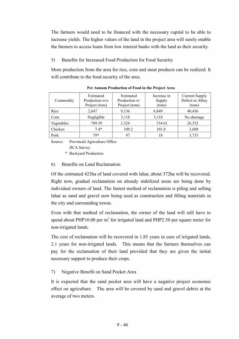
9 - 46
The farmers would need to be financed with the necessary capital to be able toincrease yields. The higher values of the land in the project area will surely enablethe farmers to access loans from low interest banks with the land as their security.
5) Benefits for Increased Food Production for Food Security
More production from the area for rice, corn and meat products can be realized. Itwill contribute to the food security of the area.
Per Annum Production of Food in the Project Area
CommodityEstimated
Production w/oProject (tons)
EstimatedProduction w/Project (tons)
Increase inSupply(tons)
Current SupplyDeficit in Albay
(tons)Rice 2,647 9,136 6,849 40,436Corn Negligible 3,118 3,118 No shortageVegetables 789.39 1,324 534.61 26,352Chicken 7.4* 109.2 101.8 3,608Pork 79* 97 18 3,735Source: Provincial Agriculture Office
JICA Survey * Backyard Production
6) Benefits on Land Reclamation
Of the estimated 423ha of land covered with lahar, about 372ha will be recovered.Right now, gradual reclamation on already stabilized areas are being done byindividual owners of land. The fastest method of reclamation is piling and sellinglahar as sand and gravel now being used as construction and filling materials inthe city and surrounding towns.
Even with that method of reclamation, the owner of the land will still have tospend about PHP10.00 per m2 for irrigated land and PHP2.50 per square meter fornon-irrigated lands.
The cost of reclamation will be recovered in 1.85 years in case of irrigated lands,2.1 years for non-irrigated lands. This means that the farmers themselves canpay for the reclamation of their land provided that they are given the initialnecessary support to produce their crops.
7) Negative Benefit on Sand Pocket Area
It is expected that the sand pocket area will have a negative project economiceffect on agriculture. The area will be covered by sand and gravel debris at theaverage of two meters.
9 - 47
Although much of the area would still be probably arable up to 2020, there isdanger that sand and gravel deposition would occur in the area. For the purposesof this project, it will be recommended that the area be acquired by thegovernment as a designated public land. Although parts of the sand pocket maybe totally arable at any point in the next twenty years, anybody farming in the areawould be doing it at his own risk.
(8) Support Programs
1) Yawa River Basin Development Project (Umbrella Support Program)
The Sabo dike would effectively protect the down slope areas of Legazpi City andDaraga and in theory, the people in the protected areas should be able to takeadvantage of the relative safety of the area. Unfortunately, the farmers have verylittle resources and capabilities to make improvements and investments on theland.
There is a need to accelerate the development in the area by creating a concertedeffort aimed at being able to economically develop the project protected area andat the same time preserve a desirable vegetative cover that would provide adesirable environmental protection to the area.
Mayon is the main watershed of the province of Albay and it is the main source ofwater for many populated and economically active areas surrounding its slopes.A deterioration of the slopes of Mayon will have a great effect on the economicactivities on the down slope areas.
The slopes of Mayon have many potentials not only for agriculture but also forindustrial development and tourism.
There are projects being proposed by the different agencies for the province ofAlbay whose components for Daraga and Legazpi can be incorporated into orassisted by one umbrella project called the Yawa River Basin DevelopmentProject, which could also be a consolidating support project for the economicdevelopment of Daraga and Legazpi City.
2) The Main Objectives of the Project:
a. To maintain optimum ecosystem along the slopes of Mayon that will notonly improve the present environmental conditions but also increase theincome of farmers working along the slopes of Mayon
b. To develop and encourage minimum tillage farming systems along thehigher slopes to reduce the exposure of farmers to danger and minimizeerosion
9 - 48
c. To improve water retention along the slopes of Mayon to reduce stress ondrainage and Sabo Project structures and reduce flooding during storms
d. To improve water quality and stabilize water supply from the slopes intosprings and tributaries feeding into the Yawa River System
e. To improve farm productivity of farmers not only for rural economicdevelopment but also for the food security of the province
3) Project Components:
a. Project Management
The personnel mostly seconded from line agencies, local government units,will provide the project management. Their basic salaries shall be drawnfrom their mother agencies. Project contractual workers and consultantswill support them.
b. Pilot Reforestation Projects
After so many failed experiences in reforestation projects, the DENR havedeveloped ideas for reforestation and agro-forestry concepts that may beimplemented not only on the National Park, but the upper slopes of thevolcano. An agro-forestry system that involves the active participation ofthe farmers, which also encourages them from cutting the trees are deemedeffective. These pilot projects will also be used for training farmers fromother parts of Mayon and the region.
c. Pilot Farms Along the Slopes of Mayon
The pilot farms to be established in different parts of the project areas willbecome model farms where farmers both from Mayon and other areas couldbe provided training. The project will introduce the planting of VetiverGrass (Morass) and Lemon Grass as hedgerows to prevent erosion andsiltation. They are also good sources of aromatic oils used as ingredientsfor perfumery for soap, insecticides, and other products. It will alsointroduce abaca and pilinut as high value crops to be intercropped withcoconut lands along the slopes of Mayon.
d. Model Rice Farms
The area near the foot of Mt. Mayon is the main rice producing area of theProvince. However, its productivity has remained low because of lowinvestments on farm inputs by the farmers, either because of lack of capital
9 - 49
or fear of losing large investment due to calamities that could wipe out thecrops planted.
The Sabo project would provide a certain degree of security for the farmersfrom flooding or destruction. This model farm will be used to train farmerson a more intensive and productive rice farming system on a three plantingseasons a year. For irrigated areas, rice-vegetable/legume-rice and for non-irrigated areas, rice-vegetable/legume-corn cropping patterns will bemodeled.
e. Technical Support and Training Center
One of the reasons for the low productivity of the farmers is lack of technicalknowledge. To increase the farm production, they need more advancedfarming technologies through educational and training programs. For thispurpose, a small training center enough to accommodate about 30 farmerswill be established at the project area.
f. Soils Laboratory
The farmers in the project area have very little information on the fertility ofthe soil they till. Accurate information on what the soil needs is veryimportant to maximize yields. Low cost and easy to operate computerizedsoil analysis equipment is now available. This laboratory can initially beoperated by the project in cooperation with the Provincial AgriculturalOffice and later on donated to the Provincial Government for operation andmaintenance.
g. Extension Activities
Farmers, having very little experience in formal education, find classroomtype training insufficient to learn new technologies. It is therefore veryimportant for them to have somebody demonstrate it for them on actualoperations. In this case, other means of instructional methods should beexplored to transfer skills to the farmers.
h. Cooperative Development
Because of the weak financial and economic capabilities of individualfarmers, it has become necessary for them to form into cooperatives in orderto pool their resources for better efficiency and productivity. In fact, manyfarmers lack the capabilities to manage cooperatives.
9 - 50
The Bicol Region is an example of an area where farmer cooperatives areneeded most but unfortunately very few cooperatives succeed.
There is therefore a need for strengthening of cooperatives through technicalsupport and education programs for the farmers. Particular attention shouldbe given to the cooperatives especially in the initial stages, and guidance andeducation through hands on operation would be considered.
There are no established cooperatives in the project area. If the farmers areto be assisted, two main cooperatives will be organized:
The Upland and Coconut Farmers’ Cooperative
This cooperative will be mainly composed by the more than 250 coconutfarmers in the 811 hectares of coconut farms in the project area. Theircapabilities will also be strengthened in order to own and operate the modelprojects plant on essential oil, and the warehouse and baling facility forabaca fibers.
The Lowland Farmers Cooperative
This cooperative will be composed of the more than 700 farmers tilling thepaddy fields of the project area. They will be assisted and trained also tooperate the feed mill, warehouse, and the piggery and poultry model projects.To strengthen these cooperatives, technical personnel will initially beprovided to them by the project until they are capable enough to managetheir enterprises.
i. Cooperative Financing and Linkage with Financial Institutions
While the initial development activities and facilities will be included asproject expenditure, the finances necessary for the operation of the projectsshould be raised by the cooperative.
The farmers can raise cooperative funds for the projects through: (a)individual contributions and investments through cooperative membershipfees or personal investments and deposits, (b) partnership with the LandBank of the Philippines (LBP) and other companies to form joint venture,and (c) easy term loans from financial institutions or non-bank institutions.
j. Marketing Support Project
A marketing support group will initially be made composed of membersdetailed from the Department of Trade and Industry, Department of
9 - 51
Agriculture, and consultants and contractual staff from the project.Marketing agreements could be forged with existing companies and majorplayers in the industry.
(8) Eco-Prevention and greenbelt Model Project
Bio-engineering, or the effective utilization of plants to prevent erosion andstabilize soil structures, is now being practiced all over the world. It is nowregarded not only as ecologically sound soil structure protection but also as verylow technology and low cost system that can be readily adopted by the residentsand farmers of the project area.
The project will consist of putting up model sites as training venues for farmers,and training programs will be regularly held along the following topics: (a)general concept for water and soil retention on slopes, (b) general concepts forgully embankment and slope erosion control, (c) nursery development, and (d)training and extension project for upland farmers.
(9) Buffer Zone green Belt Area
The dike system that will be constructed on the project area sand pocket willconsist of 1,100 meters of dam, 5,600 meters to Type B spur dikes and 600 metersof Type C spur dikes. The Type B and Type C spur dikes have unarmored topand back slope made of compacted earth. The exposed parts are susceptible toconstant erosive action from rain and may cause rill erosion and pose biggerproblems in the future.
To prevent erosion on the earth dikes and strengthen the tensile strength of thewhole dike structure, a combination of grass and trees will be planted on a 25meter strip along the 6,100 meter length spur dikes.
A total of 152,500 square meters of land will be covered with grass and pilinutplanted on a 3 meters x 3 meters distance. The excess pilinut trees will just belater trimmed or cut by natural selection process.
9.4 Institutional Strengthening Programs
9.4.1 Provincial Disaster Management System Strengthening
(1) Objectives of the Project
This program is designated with a view to upgrading managerial and operationalcapability of the Provincial Government staff in charge of disaster management(especially PDMO and PDCC), so that they can properly cope with disasters and
9 - 52
take quick response actions in accordance with the Disaster ManagementOperation Manual.
(2) Components
a. Capability building activities will be undertaken for the Provincial officers andstaff involved in the Provincial disaster management operations, especiallythose in the Provincial Management Office (PDMO) and other agenciesconcerned, through execution of periodical staff training. These trainingprograms will be implemented by holding seminars and workshops to beconducted by higher DCC or the Asia Pacific Disaster Management Center(APDMC) based in the Philippines.
b. The disaster management training will cover a wide range of functions andskills. These include planning, organization, day-to-day management activities,counter-disaster operations, crisis management activities, logistic functions,recovery management, participation in major programs such as regionaldevelopment prevention and mitigation, special skills applicable to rescue,first aid assessment, emergency relief and welfare, communications,information management and so on. These training components must beintegral parts of Basic and Advance Disaster Courses.
c. These training coursed will be prepared by the higher Disaster CoordinatingCouncil (DCC) and/or professional third parties (ex. Asian Pacific DisasterManagement Center) taking into account the existing basis of competence ofthe target personnel. The annual training program will be made up in Octoberbefore entering into negotiations about budget allocation.
d. To assure communications with the subordinate LGUs concerned(City/Municipalities and Barangays), an information network system will beestablished or improved by installing a set of the facilities and equipment suchas radio transceivers or computer sets with internet communicationconnections.
e. The disaster management center needs to upgrade accuracy and reliability ofthe data and information on vulnerabilities to hazards, hazard areas andnumber of population residing in danger areas, etc., which are essential to thedisaster-related activities and project planning. These are to be translated intomaps using GIS software.
9 - 53
f. In this program, the following will be taken up as program component:
Policy and legal arrangements to cope with the current disaster-related issues suchas optimum land use, enforcement of national building code, and so on.
! Institutional arrangement for mud and debris flow observation and monitoringfor DPWH
! Coordination of existing rules and regulations related to public safety alongMayon danger zone enacted by the Sangguniang Panlawigan ng Albay (SPA)
Capability building of PDCC/PDMO offices and staff
! Establishment of rescue equipment for skills training and actual search, rescueand recovery operations
! Installation of internet system of communication and warning informationwithin the MDCCs/CDCC of Albay
! Installation of appropriate warning information device at the barangay level! Establishment of the early and accurate forecasting, timely warning and
prompt and reliable evacuation system! Reproduction of risk map along the Mayon area, utilizing a processing
software designed for mapping and accurate data capture like GIS! Improvement of training of equipment on disaster education and information
campaign using Magnabyte! Provision of emergency operation quarters for medical and non-medical
personnel who will render 24 hours operation! Undergoing of training and education on the following:
- Advance disaster management- Vulnerability assessment and planning using GIS- Disaster management on environmental, socio-economic, meteorological,
volcanological, and seismological aspects- Disaster management on local governance- Environmental safety- Skills training on environmental high angle slope rescue- Evacuation management with health and sanitation
Networking
! Consolidation of coordination framework and networking for disastermanagement (LGUs – DCCs – PDMO – NGAs - Private Sector/NGOs).Conferences for institutional arrangements leading to policy recommendationsfor clearer guidelines
! Reorientation of cooperation in disaster coping and conclusion of anagreement on response and recovery operations among the neighboring LGUs
9 - 54
at every level. Redefining their roles and responsibilities to avoid overlappingand duplication in order to maximize resources
Organization Development
! Restructuring of the provincial system for integrating disaster mitigation intoarea development. Improvement of working relationships between DisasterCoordinating Council and Development Council.
! Restructuring/Expansion of PDMO into Provincial Public Safety Office- Expansion of PDMO’s function on public safety to augment the
economic and financial status of the province for disaster preventionworks and activities
- Involvement of the institutionalized Provincial Public Safety Office(PPSO) in and expanded program to develop and implement a multi-sectoral approach to public safety and disaster management byorganizing, utilizing and maximizing the local organic capabilities atboth human and non human resources
- Creation of programs and projects designed for implementation withinthe next five years
(3) Training Program and Estimated Cost for Capability Building
The estimated cost for administrative and operational programs are as follows.
Estimated Cost for Administrative Programs(Unit : Million PHP)
1. PPSO Extension /Field Offices 2.02. Emergency Operation Quarters 1.03. Institutionalization of Regional Education Center for Public
Safety and Disaster Management 10.0
Subtotal 13.0
9 - 55
Estimated Cost for Operational Programs
1. Emergency Ambulance Services 1.52. Public Safety Education 0.83. Traffic Management 1.24. Patrol Motorcycle Project 0.45. 10-year Reforestation Project 20.06. Research and Data Banking System 3.07. GIS-run Risk and Resource Maps 0.58. Organization of Municipal Emergency Response Intervention
Team (MERIT) 1.8
9. Strengthening of Communication and Warning System 2.010. Public Information System 0.111. Disaster Mitigation on Health Hazards at Evacuation Centers 0.5
Subtotal 31.8
Capability Building Cost
Grand Total (a + b) for Capability Building 44.8
9.4.2 Community-based Disaster Management Strengthening
(1) Objective
This program aims to extend the ongoing efforts to upgrade/strengthen the disastermanagement system of the City/Municipalities and Barangays concerned in theStudy Area.
(2) Components
a. Capacity building will be made to the city/municipality and barangay staff incharge of disaster management, through execution of periodical staff training.These training programs will be implemented by holding seminars, workshopsand drills especially on Search, Rescue and Recovery and EvacuationManagement which includes Health and Sanitation.
b. The training program will be prepared by PDMO and/or professional thirdparty considering the competence level of the target personnel. The trainingprogram will start from the Basic Disaster Management to Advance DisasterManagement going into specific assets like Disaster Management MedicalAspects, Socio-Economic Aspects, Local Governance Aspects, and others.The target participants to the training will be the BDCCs, Media, Agencies,NGOs and Volunteers/Social Workers.
c. The disaster management training will include a wide range of functions andskills relating to planning, organization, day-to-day management activities,
9 - 56
counter-disaster operations, crisis management activities, logistic functions,recovery management, special skills applicable to rescue, first aid, assessment,emergency relief and welfare, communications, information management soon.
d. Improvement of information network system to assure qualitycommunications among PDMO/PDCC, CDCC/MDCCs and BDCCs.
e. Establishment and strengthening of communication with other municipalitiesusing internet communication facilities.
f. This program will incorporate the following disaster-related component:
Capability building
! Institutional consolidation of CDCC/MDCCs including BDCCs! Strengthening of volunteer disaster operation groups through organizing and
training! Enhancement of disaster coping capacity through upgrading of the forecasting
& warning and evacuation system through internet communication facilities! Preparation of the comprehensive city/municipal land use plan including
hazard mapping & resource assessment, key commodity development strategy! Development of the integrated community disaster planning program
Advocacy
! Awareness promotion campaign and enlightenment on disaster managementthrough seminars, workshops and drills for general public, including thedisaster-related education at primary and junior schools
! Advocacy works through seminar, fora and symposia
Resettlement and Livelihood Development
! Resettlement community development program in association with livelihoodprograms and projects for 137 families from the 6 km-radius PDZ of MayonVolcano at PHP100,000 each or a total for PHP13.7 millions.
! Research studies on resettlement development
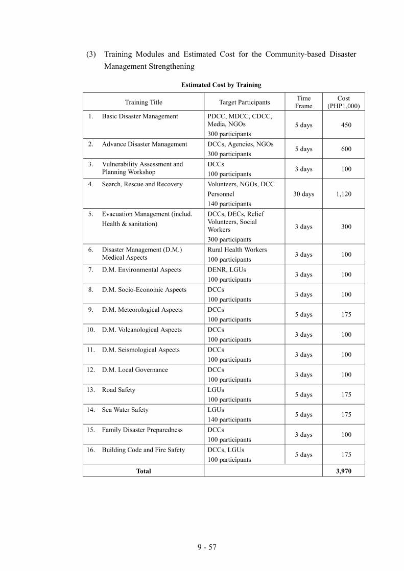
9 - 57
(3) Training Modules and Estimated Cost for the Community-based DisasterManagement Strengthening
Estimated Cost by Training
Training Title Target Participants TimeFrame
Cost(PHP1,000)
1. Basic Disaster Management PDCC, MDCC, CDCC,Media, NGOs300 participants
5 days 450
2. Advance Disaster Management DCCs, Agencies, NGOs300 participants
5 days 600
3. Vulnerability Assessment andPlanning Workshop
DCCs100 participants
3 days 100
4. Search, Rescue and Recovery Volunteers, NGOs, DCCPersonnel140 participants
30 days 1,120
5. Evacuation Management (includ.Health & sanitation)
DCCs, DECs, ReliefVolunteers, SocialWorkers300 participants
3 days 300
6. Disaster Management (D.M.)Medical Aspects
Rural Health Workers100 participants
3 days 100
7. D.M. Environmental Aspects DENR, LGUs100 participants
3 days 100
8. D.M. Socio-Economic Aspects DCCs100 participants
3 days 100
9. D.M. Meteorological Aspects DCCs100 participants
5 days 175
10. D.M. Volcanological Aspects DCCs100 participants
3 days 100
11. D.M. Seismological Aspects DCCs100 participants
3 days 100
12. D.M. Local Governance DCCs100 participants
3 days 100
13. Road Safety LGUs100 participants
5 days 175
14. Sea Water Safety LGUs140 participants
5 days 175
15. Family Disaster Preparedness DCCs100 participants
3 days 100
16. Building Code and Fire Safety DCCs, LGUs100 participants
5 days 175
Total 3,970
10 - 1
CHAPTER 10 PROJECT COST ESTIMATE
10.1 Constitution of Project Cost
Project cost comprises (a) Construction cost, (b) Government administration cost,(c) Engineering services cost, (d) Land acquisition cost, (e) Physical contingency,and (f) Price contingency. The components of each cost are given as follows:
(1) Construction Cost
The construction cost is estimated by multiplying work quantity and unit price inprinciple, except for lump sum items such as preparatory works. The workquantity is estimated based on project layout, outline dimensions of structures, andproposed capacities of the facilities. The unit price of each work item isdetermined by referring to the unit price obtained from DPWH and the recentbidding data of similar projects in Philippines.
1) Unit Price
The unit price is composed of two parts, (a) the direct cost consisting of the laborcost, material cost, and equipment expenses, and (b) the indirect cost consisting ofoverhead expenses, unforeseen contingencies, miscellaneous expenses, andcontractor's profit, pursuant to the Department Order (DPWH) No. 30.
2) Preparatory Works
The preparatory works cover the contractor's preparation works such as temporarybuildings with water and power supply system, temporary access road to the sites,dewatering works, and relocation works of obstacles. The cost for preparatoryworks is estimated at 5% of the total construction cost.
(2) Government Administration Cost
Government administration cost comprises mainly salary cost, equipment cost,and office running and maintenance cost. The cost is estimated based on theimplementation schedule of the priority projects indicated in Chapter 11.
(3) Engineering Services Cost
The engineering services cost comprises mainly remuneration, transportation cost,and office running cost. The cost is estimated based on the implementationschedule of the priority projects indicated in Chapter 11.
10 - 2
(4) Land Acquisition Cost
This cost covers the land acquisition of (a) the sand pocketing area includingconstruction area of sabo dam and training dikes, and (b) the construction area ofchannel improvement and pump drainage.
For the urban drainage project, the cost is estimated by using the latest zonal landmarket value of affected area.
On the other hand, for the sand pocketing area, there seems to be no land marketvalue in the area. Therefore, the cost is determined by the following manner:
a. Assessment of annual net income based on the productivity for eachagricultural field, and calculation of present value during the period of 30years for the annual net income.
b. Calculation of present value during the period of 30 years for lease charge foreach agricultural field.
c. Selection of lower value by comparison of these two present values.
d. It should be noted that the cost for the sand pocketing area should beexamined in detail in the implementation stage of the project.
(5) Contingencies
The contingencies required for the project budgeting comprise (a) physicalcontingency to cover unforeseen changes of physical conditions and (b) pricecontingency to compensate future price escalation.
The rates of physical contingency is estimated at 10% of the total cost forconstruction cost, government administration cost, engineering services cost, andland acquisition cost.
The price contingency is estimated with the assumed price escalation rate of2.34% per annum for foreign currency portion and 7.85% per annum for localcurrency portion. The rate of 2.34% is derived from the latest projection of MUV(Manufacturing Unit Value in G-5 countries) during 1999-2005 indicated byWorld Bank, while the rate of 7.85% is the average escalation rate of consumerprices during ten years in Philippines indicated by IMF.
10.2 Condition of Project Cost
(1) Basic Condition of Cost Estimate
The project cost is estimated with the following basic conditions and assumptions.
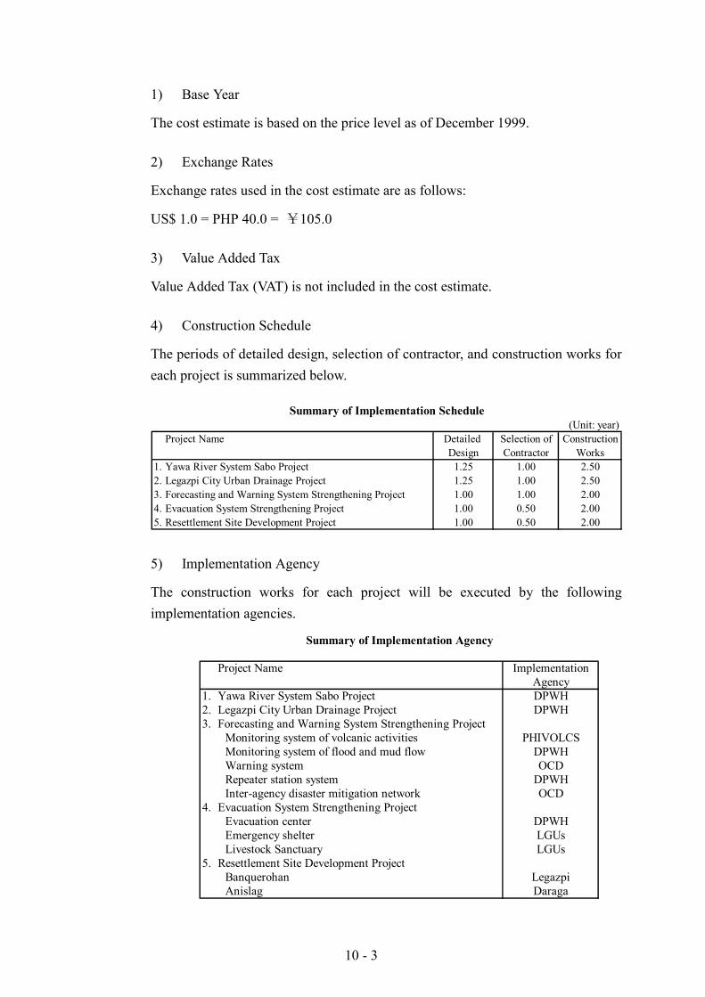
10 - 3
1) Base Year
The cost estimate is based on the price level as of December 1999.
2) Exchange Rates
Exchange rates used in the cost estimate are as follows:
US$ 1.0 = PHP 40.0 = ¥105.0
3) Value Added Tax
Value Added Tax (VAT) is not included in the cost estimate.
4) Construction Schedule
The periods of detailed design, selection of contractor, and construction works foreach project is summarized below.
(Unit: year)Project Name Detailed Selection of Construction
Design Contractor Works1. Yawa River System Sabo Project 1.25 1.00 2.502. Legazpi City Urban Drainage Project 1.25 1.00 2.503. Forecasting and Warning System Strengthening Project 1.00 1.00 2.004. Evacuation System Strengthening Project 1.00 0.50 2.005. Resettlement Site Development Project 1.00 0.50 2.00
Summary of Implementation Schedule
5) Implementation Agency
The construction works for each project will be executed by the followingimplementation agencies.
Project Name ImplementationAgency
1. Yawa River System Sabo Project DPWH2. Legazpi City Urban Drainage Project DPWH3. Forecasting and Warning System Strengthening Project
Monitoring system of volcanic activities PHIVOLCSMonitoring system of flood and mud flow DPWHWarning system OCDRepeater station system DPWHInter-agency disaster mitigation network OCD
4. Evacuation System Strengthening ProjectEvacuation center DPWHEmergency shelter LGUsLivestock Sanctuary LGUs
5. Resettlement Site Development ProjectBanquerohan LegazpiAnislag Daraga
Summary of Implementation Agency
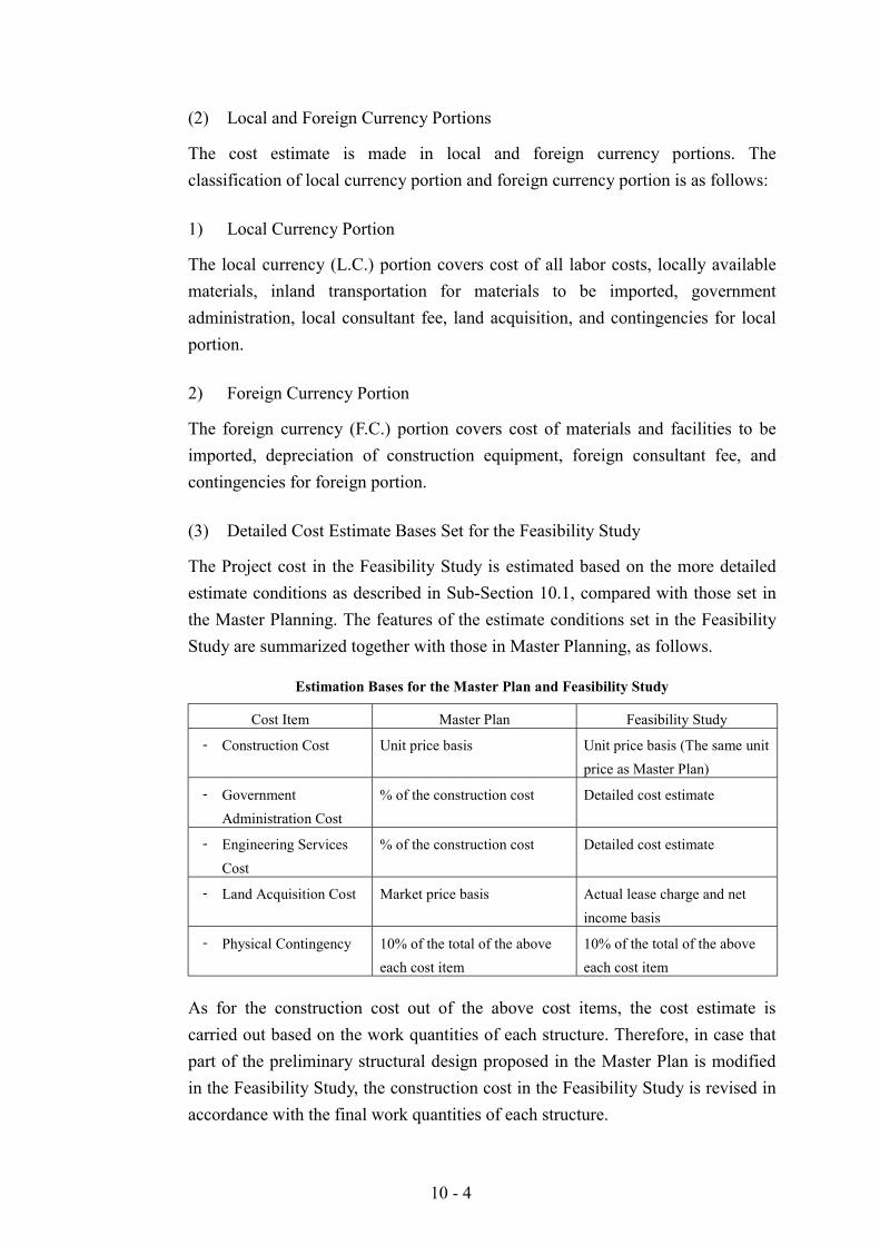
10 - 4
(2) Local and Foreign Currency Portions
The cost estimate is made in local and foreign currency portions. Theclassification of local currency portion and foreign currency portion is as follows:
1) Local Currency Portion
The local currency (L.C.) portion covers cost of all labor costs, locally availablematerials, inland transportation for materials to be imported, governmentadministration, local consultant fee, land acquisition, and contingencies for localportion.
2) Foreign Currency Portion
The foreign currency (F.C.) portion covers cost of materials and facilities to beimported, depreciation of construction equipment, foreign consultant fee, andcontingencies for foreign portion.
(3) Detailed Cost Estimate Bases Set for the Feasibility Study
The Project cost in the Feasibility Study is estimated based on the more detailedestimate conditions as described in Sub-Section 10.1, compared with those set inthe Master Planning. The features of the estimate conditions set in the FeasibilityStudy are summarized together with those in Master Planning, as follows.
Estimation Bases for the Master Plan and Feasibility Study
Cost Item Master Plan Feasibility Study
- Construction Cost Unit price basis Unit price basis (The same unitprice as Master Plan)
- GovernmentAdministration Cost
% of the construction cost Detailed cost estimate
- Engineering ServicesCost
% of the construction cost Detailed cost estimate
- Land Acquisition Cost Market price basis Actual lease charge and netincome basis
- Physical Contingency 10% of the total of the aboveeach cost item
10% of the total of the aboveeach cost item
As for the construction cost out of the above cost items, the cost estimate iscarried out based on the work quantities of each structure. Therefore, in case thatpart of the preliminary structural design proposed in the Master Plan is modifiedin the Feasibility Study, the construction cost in the Feasibility Study is revised inaccordance with the final work quantities of each structure.
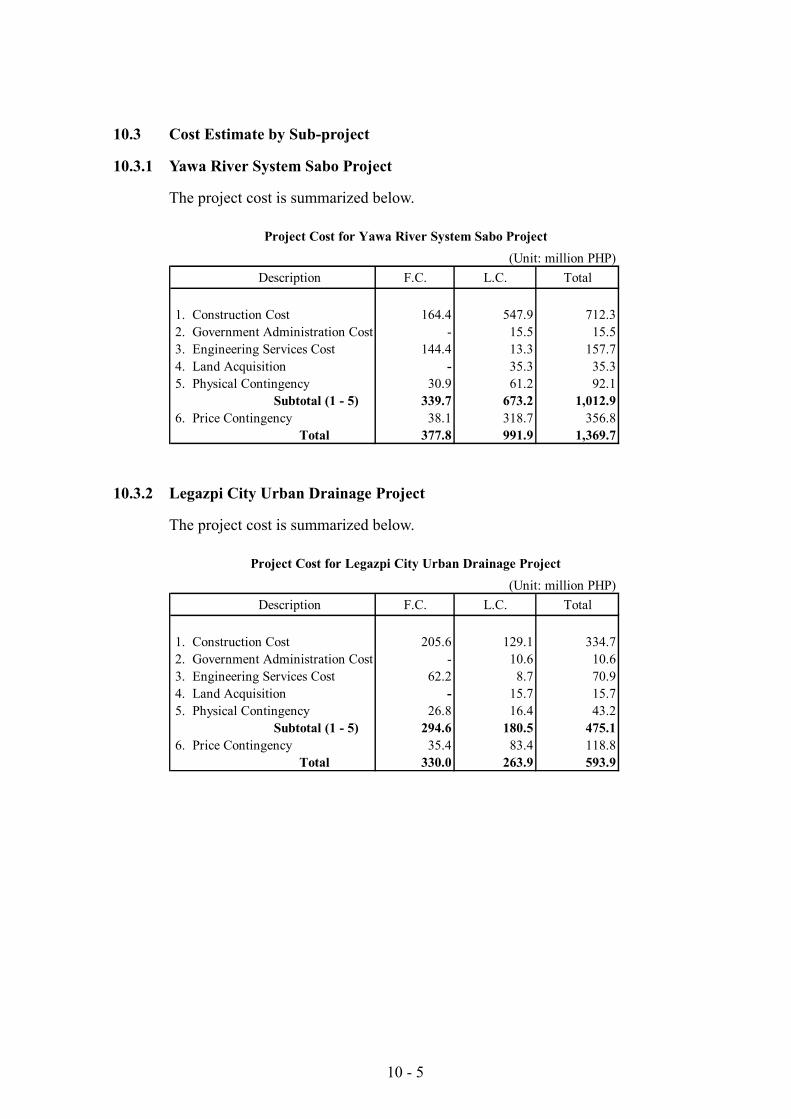
10 - 5
10.3 Cost Estimate by Sub-project
10.3.1 Yawa River System Sabo Project
The project cost is summarized below.
(Unit: million PHP)Description F.C. L.C. Total
1. Construction Cost 164.4 547.9 712.32. Government Administration Cost - 15.5 15.53. Engineering Services Cost 144.4 13.3 157.74. Land Acquisition - 35.3 35.35. Physical Contingency 30.9 61.2 92.1
Subtotal (1 - 5) 339.7 673.2 1,012.96. Price Contingency 38.1 318.7 356.8
Total 377.8 991.9 1,369.7
Project Cost for Yawa River System Sabo Project
10.3.2 Legazpi City Urban Drainage Project
The project cost is summarized below.
(Unit: million PHP)Description F.C. L.C. Total
1. Construction Cost 205.6 129.1 334.72. Government Administration Cost - 10.6 10.63. Engineering Services Cost 62.2 8.7 70.94. Land Acquisition - 15.7 15.75. Physical Contingency 26.8 16.4 43.2
Subtotal (1 - 5) 294.6 180.5 475.16. Price Contingency 35.4 83.4 118.8
Total 330.0 263.9 593.9
Project Cost for Legazpi City Urban Drainage Project
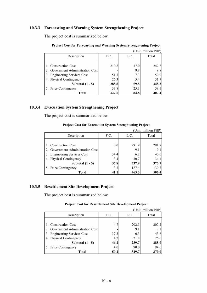
10 - 6
10.3.3 Forecasting and Warning System Strengthening Project
The project cost is summarized below.
(Unit: million PHP)Description F.C. L.C. Total
1. Construction Cost 210.8 37.0 247.82. Government Administration Cost - 9.8 9.83. Engineering Services Cost 51.7 7.3 59.04. Physical Contingency 26.3 5.4 31.7
Subtotal (1 - 5) 288.8 59.5 348.35. Price Contingency 33.8 25.3 59.1
Total 322.6 84.8 407.4
Project Cost for Forecasting and Warning System Strenghtening Project
10.3.4 Evacuation System Strengthening Project
The project cost is summarized below.
(Unit: million PHP)Description F.C. L.C. Total
1. Construction Cost 0.0 291.9 291.92. Government Administration Cost - 9.1 9.13. Engineering Services Cost 34.4 6.2 40.64. Physical Contingency 3.4 30.7 34.1
Subtotal (1 - 5) 37.8 337.9 375.75. Price Contingency 3.3 127.4 130.7
Total 41.1 465.3 506.4
Project Cost for Evacuation System Strenghtening Project
10.3.5 Resettlement Site Development Project
The project cost is summarized below.
(Unit: million PHP)Description F.C. L.C. Total
1. Construction Cost 4.7 202.5 207.22. Government Administration Cost - 9.1 9.13. Engineering Services Cost 37.3 6.3 43.64. Physical Contingency 4.2 21.8 26.0
Subtotal (1 - 5) 46.2 239.7 285.95. Price Contingency 4.0 90.0 94.0
Total 50.2 329.7 379.9
Project Cost for Resettlement Site Development Project
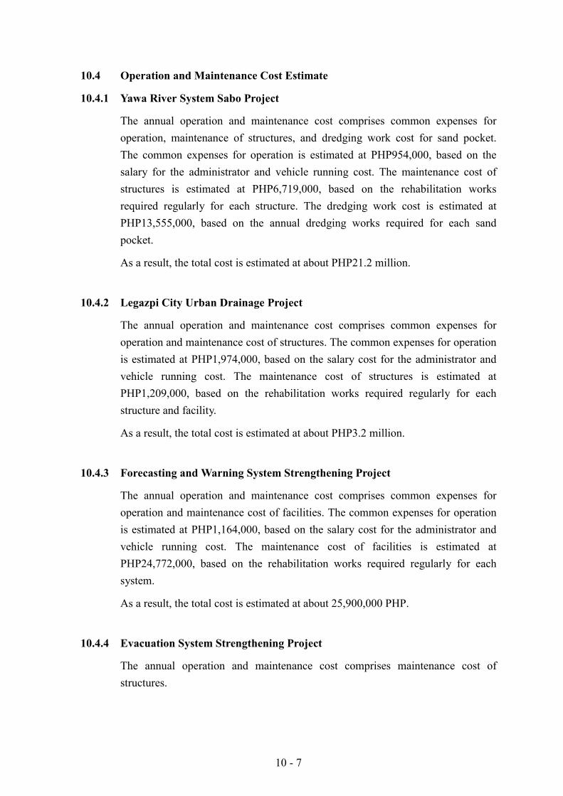
10 - 7
10.4 Operation and Maintenance Cost Estimate
10.4.1 Yawa River System Sabo Project
The annual operation and maintenance cost comprises common expenses foroperation, maintenance of structures, and dredging work cost for sand pocket.The common expenses for operation is estimated at PHP954,000, based on thesalary for the administrator and vehicle running cost. The maintenance cost ofstructures is estimated at PHP6,719,000, based on the rehabilitation worksrequired regularly for each structure. The dredging work cost is estimated atPHP13,555,000, based on the annual dredging works required for each sandpocket.
As a result, the total cost is estimated at about PHP21.2 million.
10.4.2 Legazpi City Urban Drainage Project
The annual operation and maintenance cost comprises common expenses foroperation and maintenance cost of structures. The common expenses for operationis estimated at PHP1,974,000, based on the salary cost for the administrator andvehicle running cost. The maintenance cost of structures is estimated atPHP1,209,000, based on the rehabilitation works required regularly for eachstructure and facility.
As a result, the total cost is estimated at about PHP3.2 million.
10.4.3 Forecasting and Warning System Strengthening Project
The annual operation and maintenance cost comprises common expenses foroperation and maintenance cost of facilities. The common expenses for operationis estimated at PHP1,164,000, based on the salary cost for the administrator andvehicle running cost. The maintenance cost of facilities is estimated atPHP24,772,000, based on the rehabilitation works required regularly for eachsystem.
As a result, the total cost is estimated at about 25,900,000 PHP.
10.4.4 Evacuation System Strengthening Project
The annual operation and maintenance cost comprises maintenance cost ofstructures.
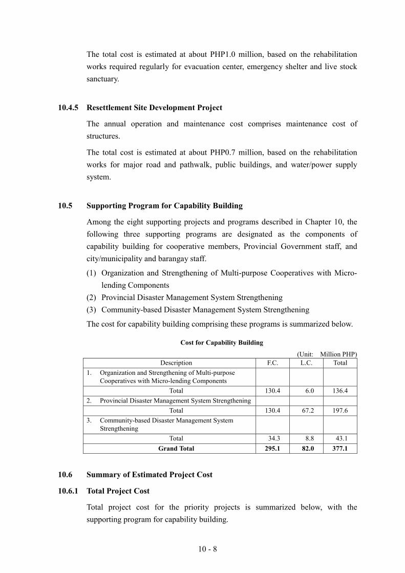
10 - 8
The total cost is estimated at about PHP1.0 million, based on the rehabilitationworks required regularly for evacuation center, emergency shelter and live stocksanctuary.
10.4.5 Resettlement Site Development Project
The annual operation and maintenance cost comprises maintenance cost ofstructures.
The total cost is estimated at about PHP0.7 million, based on the rehabilitationworks for major road and pathwalk, public buildings, and water/power supplysystem.
10.5 Supporting Program for Capability Building
Among the eight supporting projects and programs described in Chapter 10, thefollowing three supporting programs are designated as the components ofcapability building for cooperative members, Provincial Government staff, andcity/municipality and barangay staff.
(1) Organization and Strengthening of Multi-purpose Cooperatives with Micro-lending Components
(2) Provincial Disaster Management System Strengthening(3) Community-based Disaster Management System Strengthening
The cost for capability building comprising these programs is summarized below.
Cost for Capability Building
(Unit: Million PHP)Description F.C. L.C. Total
1. Organization and Strengthening of Multi-purposeCooperatives with Micro-lending Components
Total 130.4 6.0 136.42. Provincial Disaster Management System Strengthening
Total 130.4 67.2 197.63. Community-based Disaster Management System
StrengtheningTotal 34.3 8.8 43.1
Grand Total 295.1 82.0 377.1
10.6 Summary of Estimated Project Cost
10.6.1 Total Project Cost
Total project cost for the priority projects is summarized below, with thesupporting program for capability building.
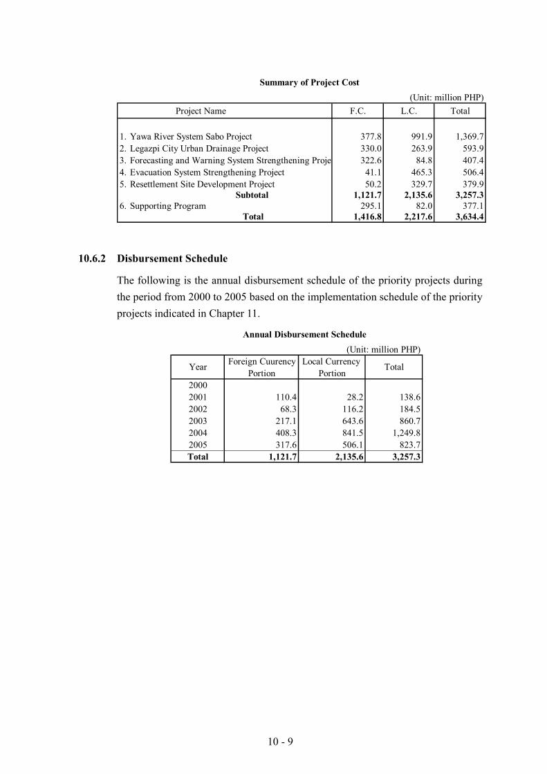
10 - 9
(Unit: million PHP)Project Name F.C. L.C. Total
1. Yawa River System Sabo Project 377.8 991.9 1,369.72. Legazpi City Urban Drainage Project 330.0 263.9 593.93. Forecasting and Warning System Strengthening Projec 322.6 84.8 407.44. Evacuation System Strengthening Project 41.1 465.3 506.45. Resettlement Site Development Project 50.2 329.7 379.9
Subtotal 1,121.7 2,135.6 3,257.36. Supporting Program 295.1 82.0 377.1
Total 1,416.8 2,217.6 3,634.4
Summary of Project Cost
10.6.2 Disbursement Schedule
The following is the annual disbursement schedule of the priority projects duringthe period from 2000 to 2005 based on the implementation schedule of the priorityprojects indicated in Chapter 11.
(Unit: million PHP)Foreign Cuurency Local Currency
Portion Portion20002001 110.4 28.2 138.62002 68.3 116.2 184.52003 217.1 643.6 860.72004 408.3 841.5 1,249.82005 317.6 506.1 823.7Total 1,121.7 2,135.6 3,257.3
Year Total
Annual Disbursement Schedule

11 - 1
CHAPTER 11 IMPLEMENTATION PLAN
As described in Chapter 7: Priority Projects for Feasibility Study, the followingprojects and programs have been presented as priority projects and supportingprojects and programs.
(1) Priority Projects
! Yawa River System Sabo Project! Legazpi City Urban Drainage Project! Forecasting and Warning System Strengthening Project! Evacuation System Strengthening Project! Resettlement Sites Development Project
(2) Supporting Projects and Programs
! Organization and Strengthening of Multi-purpose Cooperatives withMicro Credit
! Hollow Block Production! Agro-industry Development (Abaca, Pilinut and Coco Coir)! Aggregate Production Plant Project! Productivity Enhancement Programs in the Protected Area! Provincial Disaster Management System Strengthening! Community-based Disaster Management Strengthening
The details of each project are described in Chapters 8 and 9.
This chapter presents the following four issues:
! Issues in project implementationDescription on basic idea on project implementation
! Implementing organizationDescription on implementation arrangement
! Implementation scheduleDescription on implementation schedule of the projects and programs
! Project cost sharing among implementing organizationsProposal on cost sharing plan among implementing organizations
11.1 Issues in Project Implementation
Local governments are expected to play a greater role in development activities.Considerable efforts in devolution have been made since the enactment of LocalGovernment Code in 1991, however the process is incomplete. The progress in
11 - 2
devolution so far has been made mostly in social welfare, agriculture,environment and health sectors but less in public works sector. LGUs complainlack of finance due to inadequate revenue allotments from the nationalgovernment. There are some confusions on the three levels of government –national, provincial and city/municipality – due to the absence of detailedguidelines on project implementation responsibility. Thus, the enactment of LocalGovernment Code and subsequent devolution of responsibilities for localgovernment resulted to a new dimension of implementation issues.
11.1.1 Project Implementation by LGUs and by National Government
(1) NEDA Policy Framework
Investment Coordination Committee of NEDA issued a “Policy framework fornational government assistance for the financing of local government project withenvironmental and social objectives” in 1998. Though it will be the policy ofnational government to support the financing of devolved activities, NEDA admitsthat such support will be limited, temporary, and targeted at selected groups ofLGUs.
National government pay due attention to the following three aspects whenassessing the needs for financing and management intervention in infrastructuredevelopment projects.
1) Equity (National Minimum)
If LGUs are unable to provide the minimum level of services to their constituents,national government may intervene in its service provision. The eligibility ofLGUs will be based on income class and on economic class (as may be measuredby poverty incidence).
2) Externalities
Intervention by national government is justified by spatial externalities, or whenbenefits and/or costs of public services provided by an LGU are realized by non-residents.
3) Economies of Scale
The provision of some services can be made more cost-effective if the areadesignated for a service is larger than the jurisdiction of a single LGU.
LGU initiative in project implementation is important for the following reasons:
11 - 3
(1) it would make the recipient (LGU) a major stakeholder, (2) it can be a goodindicator of the LGU’s need for the project, and (3) it can influence the LGU’sspending priorities to activities with positive externalities. The LGU counterpartwould have to be large enough to force the LGU and the community to decide forthemselves if the project is the best investment for their own resources.Counterpart from the community can be in-kind resources that can be supplied byits members such as labor, local materials, and right-of-way.
Recurrent operation and maintenance expenditures will be given low priority fornational government grants. It is necessary to establish mechanisms to enableLGUs to collect user charges to raise revenue for the operation and maintenanceof local public facilities.
(2) Cost Sharing Examples
1) Flood Control and Road
There are two actual cost sharing agreements reached between DPWH and LGUs.One is KAMANAVA Flood Control and Drainage System Improvement Project(Metro Manila), and the other case is the Butuan City (Mindanao) CircumstantialRoad and Second Bridge. In the case of KAMANAVA Project, the Municipality ofMalabon will collaborate in resettlement of people to be affected by constructionworks. The City of Butuan is agreed to shoulder the Road right of way acquisitioncost of the project in the amount not exceeding 5 Million Pesos.
2) Irrigation and Agrarian Reform
Southern Philippines Irrigation Sector (ADB)
This project will construct and improve small to medium – scale irrigationsystems, strengthen irrigation operation and maintenance. While executing agencyof this Project is National Irrigation Administration (NIA), irrigators’ associationsas beneficiaries will contribute 25 % of total construction costs of newlyconstructed or rehabilitated irrigation facilities in order to generate a sense ofownership.
Agrarian Reform Community Development (IBRD)
This project has three components: a) community development and technicalassistance, b) rural infrastructure, and c) agricultural and enterprise development.Oversight responsibility for the project rests with the Department of AgrarianReform. Project costs are estimated at about US $ 106 million. The cost sharingplan is shown below.
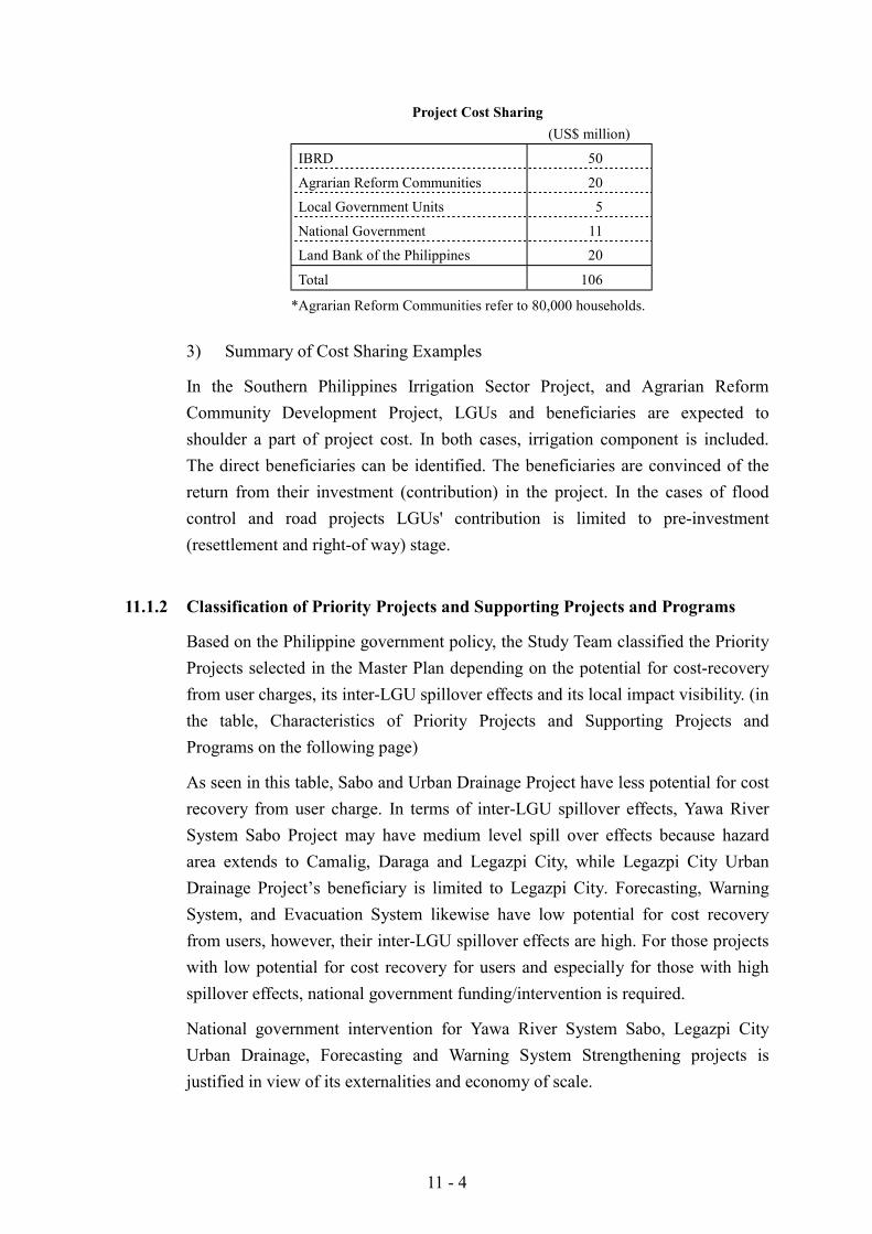
11 - 4
Project Cost Sharing(US$ million)
IBRD 50
Agrarian Reform Communities 20
Local Government Units 5
National Government 11
Land Bank of the Philippines 20
Total 106
*Agrarian Reform Communities refer to 80,000 households.
3) Summary of Cost Sharing Examples
In the Southern Philippines Irrigation Sector Project, and Agrarian ReformCommunity Development Project, LGUs and beneficiaries are expected toshoulder a part of project cost. In both cases, irrigation component is included.The direct beneficiaries can be identified. The beneficiaries are convinced of thereturn from their investment (contribution) in the project. In the cases of floodcontrol and road projects LGUs' contribution is limited to pre-investment(resettlement and right-of way) stage.
11.1.2 Classification of Priority Projects and Supporting Projects and Programs
Based on the Philippine government policy, the Study Team classified the PriorityProjects selected in the Master Plan depending on the potential for cost-recoveryfrom user charges, its inter-LGU spillover effects and its local impact visibility. (inthe table, Characteristics of Priority Projects and Supporting Projects andPrograms on the following page)
As seen in this table, Sabo and Urban Drainage Project have less potential for costrecovery from user charge. In terms of inter-LGU spillover effects, Yawa RiverSystem Sabo Project may have medium level spill over effects because hazardarea extends to Camalig, Daraga and Legazpi City, while Legazpi City UrbanDrainage Project’s beneficiary is limited to Legazpi City. Forecasting, WarningSystem, and Evacuation System likewise have low potential for cost recoveryfrom users, however, their inter-LGU spillover effects are high. For those projectswith low potential for cost recovery for users and especially for those with highspillover effects, national government funding/intervention is required.
National government intervention for Yawa River System Sabo, Legazpi CityUrban Drainage, Forecasting and Warning System Strengthening projects isjustified in view of its externalities and economy of scale.
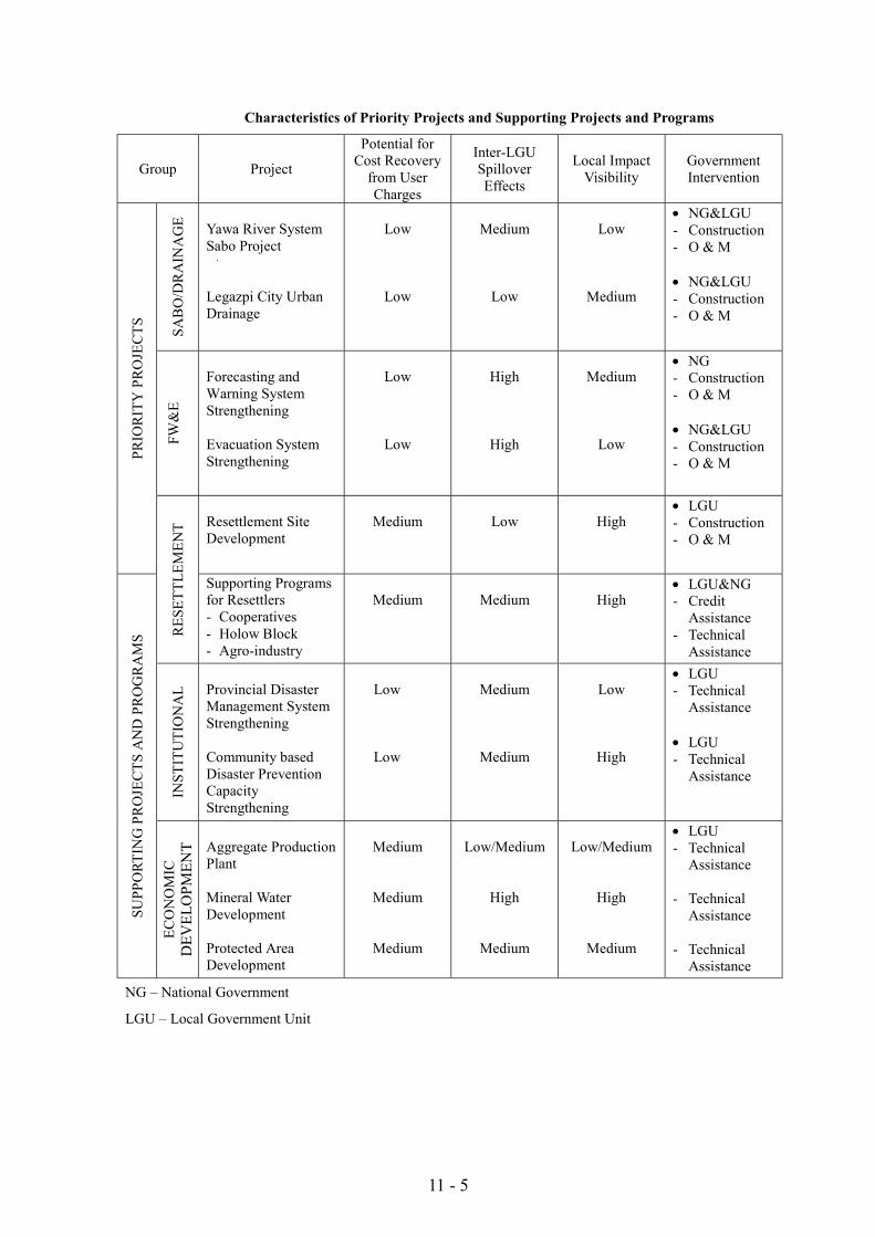
11 - 5
Characteristics of Priority Projects and Supporting Projects and Programs
Group Project
Potential forCost Recovery
from UserCharges
Inter-LGUSpilloverEffects
Local ImpactVisibility
GovernmentIntervention
SAB
O/D
RA
INA
GE Yawa River System
Sabo Project
Legazpi City UrbanDrainage
Low
Low
Medium
Low
Low
Medium
! NG&LGU- Construction- O & M
! NG&LGU- Construction- O & M
FW&
E
Forecasting andWarning SystemStrengthening
Evacuation SystemStrengthening
Low
Low
High
High
Medium
Low
! NG- Construction- O & M
! NG&LGU- Construction- O & MPR
IOR
ITY
PR
OJE
CTS
Resettlement SiteDevelopment
Medium Low High! LGU- Construction- O & M
RES
ETTL
EMEN
T
Supporting Programsfor Resettlers- Cooperatives- Holow Block- Agro-industry
Medium Medium High! LGU&NG- Credit
Assistance- Technical
Assistance
INST
ITU
TIO
NA
L Provincial DisasterManagement SystemStrengthening
Community basedDisaster PreventionCapacityStrengthening
Low
Low
Medium
Medium
Low
High
! LGU- Technical
Assistance
! LGU- Technical
Assistance
SUPP
ORT
ING
PR
OJE
CTS
AN
D P
RO
GR
AM
S
ECO
NO
MIC
DEV
ELO
PMEN
T Aggregate ProductionPlant
Mineral WaterDevelopment
Protected AreaDevelopment
Medium
Medium
Medium
Low/Medium
High
Medium
Low/Medium
High
Medium
! LGU- Technical
Assistance
- TechnicalAssistance
- TechnicalAssistance
NG – National Government
LGU – Local Government Unit
11 - 6
However, LGUs financing and management intervention is also consideredimportant. Efforts have to be made to encourage local ownership and adoption ofparticipatory approaches in project design, implementation and O&M.
For those projects with medium level potential for cost recovery, local governmentunits should take the initiative in project implementation. The projects of thiscategory include Resettlement Site Development, Supporting Programs forResettlers, Aggregate Production Plant, and Mineral Water Development.
These projects can expect cost recovery from users. For example, those peoplewho settled to resettlement site can contribute to LGUs through Community Tax1
and Real Property Tax. In addition to such taxing schemes, Legazpi City has aplan to charge 50 Pesos per month as Operation and Maintenance charge forBanquerohan resettlement site.
For Supporting Programs for Resettlers, training costs shall be borne bybeneficiaries (resettlers).
Business tax collection is expected from aggregate production, mineral water andagro-industry. Business tax is 100% retained at city/municipality. In the case ofLegazpi City, a share of business tax to total revenue is approximately 10% in1998.
In case of aggregate production, tax on sand, gravel and other quarry resourcescan also be expected.
11.2 Implementing Organization
11.2.1 Profile of Related Organizations
Table “Profile of Related Organizations” describes the related organizations’mandate, budget, and number of staff, number of engineer or professional staffand project implementation experiences. As seen in the table, as nationalgovernment agencies, DPWH only has project implementation in various sectorsincluding flood control, road, bridges, drainage, sabo and school building.
While the Local Government Code of 1991 stipulates the transfer of responsibilityof service delivery to LGUs, LGUs still do not have sufficient capacity for projectimplementation. Neither Legazpi City nor Daraga Municipality has capacity toimplement Yawa River System Sabo, Legazpi City Urban Drainage Project,
1 Collected Real Property Tax is shared among Province (35%), City/Municipality (40%), and Barangay(25%), Community Tax is retained 100% at City/Municipality.
11 - 7
Forecasting and Warning System Strengthening Project. There are severalconstraints:
1) They do not have experience in Sabo, Drainage and Forecasting projects;2) They do not have sufficient number of engineers to plan and manage the
projects, - Legazpi City has licensed 18 engineers and Daraga, only 1engineer-;
3) Their annual budget is small – Project cost for Yawa River System SaboProject is seven times bigger than Legazpi City’s annual budget.
Legazpi City and Daraga Municipality citizens are direct beneficiaries of theproject. However, Legazpi City and Daraga Municipality’s contribution to theYawa Sabo and Urban Drainage Projects will be limited to land acquisition due tothe above mentioned constraints (capacity of LGUs).
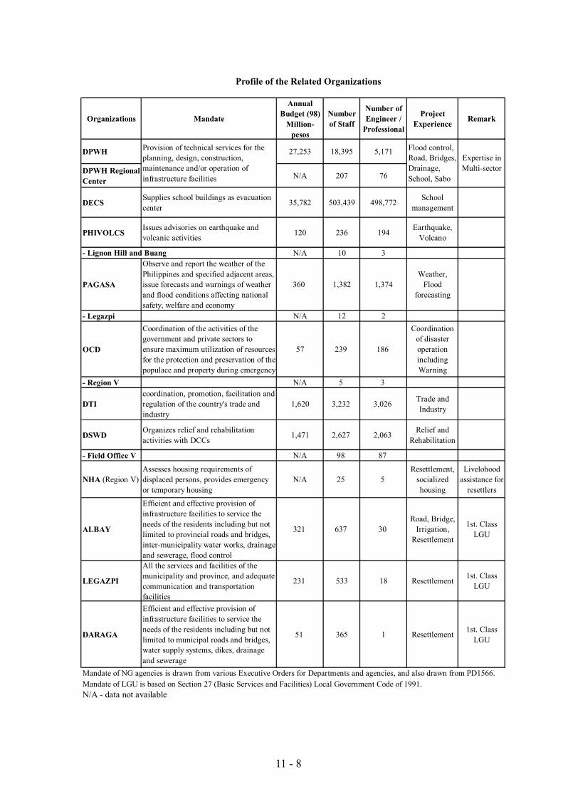
11 - 8
Profile of the Related Organizations
Organizations Mandate
AnnualBudget (98)
Million-pesos
Numberof Staff
Number ofEngineer /
Professional
ProjectExperience Remark
DPWH 27,253 18,395 5,171
DPWH RegionalCenter
N/A 207 76
DECSSupplies school buildings as evacuationcenter 35,782 503,439 498,772 School
management
PHIVOLCSIssues advisories on earthquake andvolcanic activities 120 236 194 Earthquake,
Volcano
N/A 10 3
PAGASA
Observe and report the weather of thePhilippines and specified adjacent areas,issue forecasts and warnings of weatherand flood conditions affecting nationalsafety, welfare and economy
360 1,382 1,374Weather,
Floodforecasting
- Legazpi N/A 12 2
OCD
Coordination of the activities of thegovernment and private sectors toensure maximum utilization of resourcesfor the protection and preservation of thepopulace and property during emergency
57 239 186
Coordinationof disasteroperationincludingWarning
- Region V N/A 5 3
DTIcoordination, promotion, facilitation andregulation of the country's trade andindustry
1,620 3,232 3,026 Trade andIndustry
DSWDOrganizes relief and rehabilitationactivities with DCCs 1,471 2,627 2,063 Relief and
Rehabilitation
- Field Office V N/A 98 87
NHA (Region V)Assesses housing requirements ofdisplaced persons, provides emergencyor temporary housing
N/A 25 5Resettlement,
socializedhousing
Livelohoodassistance for
resettlers
ALBAY
Efficient and effective provision ofinfrastructure facilities to service theneeds of the residents including but notlimited to provincial roads and bridges,inter-municipality water works, drainageand sewerage, flood control
321 637 30Road, Bridge,
Irrigation,Resettlement
1st. ClassLGU
LEGAZPI
All the services and facilities of themunicipality and province, and adequatecommunication and transportationfacilities
231 533 18 Resettlement 1st. ClassLGU
DARAGA
Efficient and effective provision ofinfrastructure facilities to service theneeds of the residents including but notlimited to municipal roads and bridges,water supply systems, dikes, drainageand sewerage
51 365 1 Resettlement 1st. ClassLGU
Mandate of NG agencies is drawn from various Executive Orders for Departments and agencies, and also drawn from PD1566.Mandate of LGU is based on Section 27 (Basic Services and Facilities) Local Government Code of 1991. N/A - data not available
- Lignon Hill and Buang
Provision of technical services for theplanning, design, construction,maintenance and/or operation ofinfrastructure facilities
Flood control,Road, Bridges,Drainage,School, Sabo
Expertise inMulti-sector
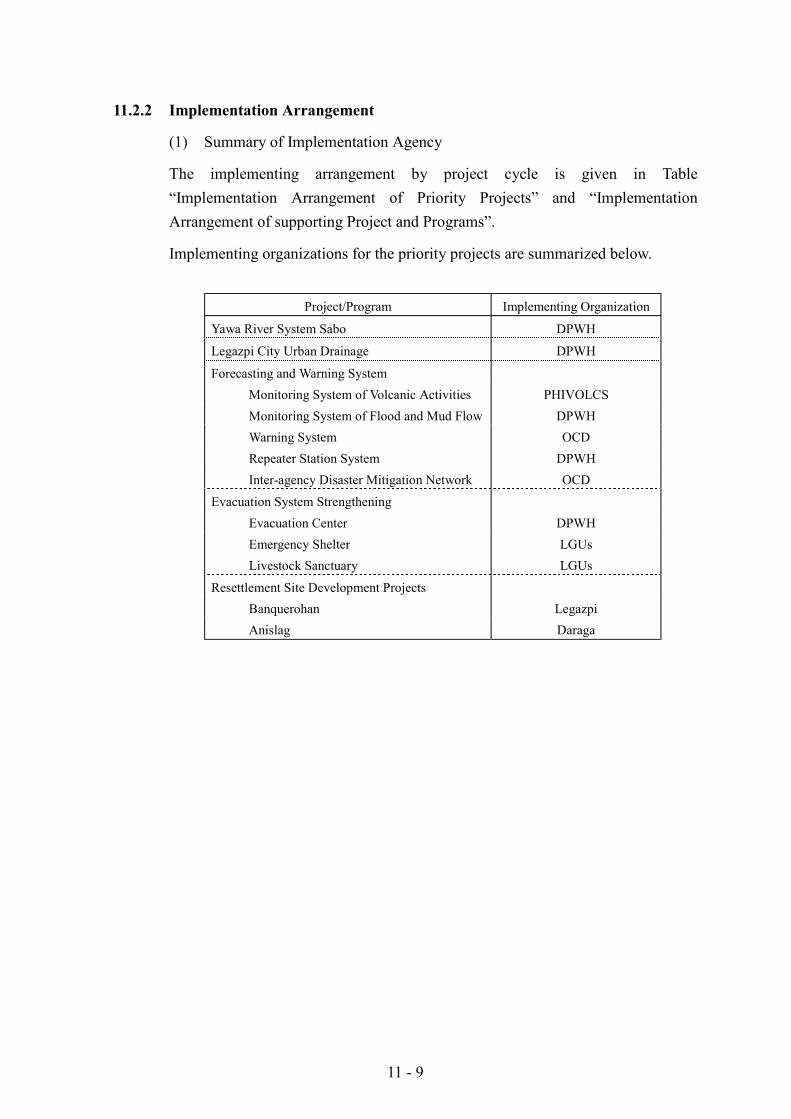
11 - 9
11.2.2 Implementation Arrangement
(1) Summary of Implementation Agency
The implementing arrangement by project cycle is given in Table“Implementation Arrangement of Priority Projects” and “ImplementationArrangement of supporting Project and Programs”.
Implementing organizations for the priority projects are summarized below.
Project/Program Implementing Organization
Yawa River System Sabo DPWH
Legazpi City Urban Drainage DPWH
Forecasting and Warning SystemMonitoring System of Volcanic Activities PHIVOLCSMonitoring System of Flood and Mud Flow DPWHWarning System OCDRepeater Station System DPWHInter-agency Disaster Mitigation Network OCD
Evacuation System StrengtheningEvacuation Center DPWHEmergency Shelter LGUsLivestock Sanctuary LGUs
Resettlement Site Development ProjectsBanquerohan LegazpiAnislag Daraga
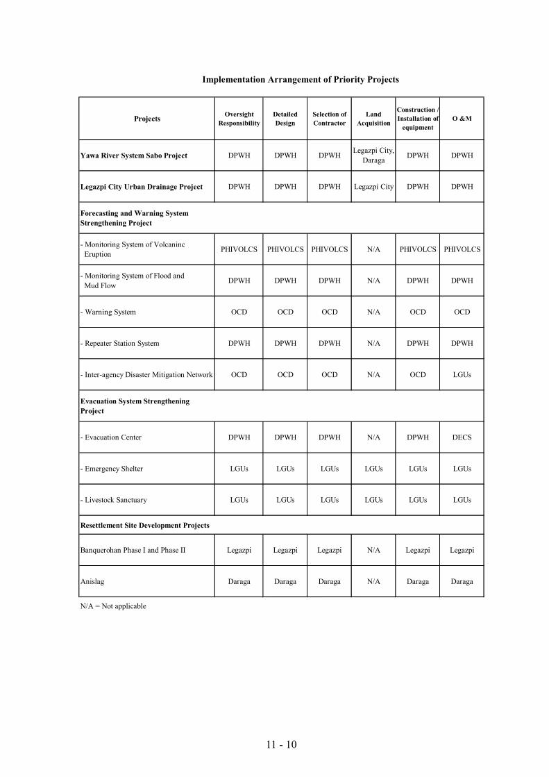
11 - 10
Implementation Arrangement of Priority Projects
Projects OversightResponsibility
DetailedDesign
Selection ofContractor
LandAcquisition
Construction /Installation of
equipmentO &M
Yawa River System Sabo Project DPWH DPWH DPWH Legazpi City,Daraga DPWH DPWH
Legazpi City Urban Drainage Project DPWH DPWH DPWH Legazpi City DPWH DPWH
Forecasting and Warning SystemStrengthening Project
- Monitoring System of Volcaninc Eruption PHIVOLCS PHIVOLCS PHIVOLCS N/A PHIVOLCS PHIVOLCS
- Monitoring System of Flood and Mud Flow DPWH DPWH DPWH N/A DPWH DPWH
- Warning System OCD OCD OCD N/A OCD OCD
- Repeater Station System DPWH DPWH DPWH N/A DPWH DPWH
- Inter-agency Disaster Mitigation Network OCD OCD OCD N/A OCD LGUs
Evacuation System StrengtheningProject
- Evacuation Center DPWH DPWH DPWH N/A DPWH DECS
- Emergency Shelter LGUs LGUs LGUs LGUs LGUs LGUs
- Livestock Sanctuary LGUs LGUs LGUs LGUs LGUs LGUs
Resettlement Site Development Projects
Banquerohan Phase I and Phase II Legazpi Legazpi Legazpi N/A Legazpi Legazpi
Anislag Daraga Daraga Daraga N/A Daraga Daraga
N/A = Not applicable
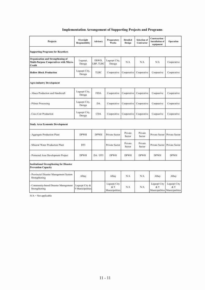
11 - 11
Implementation Arrangement of Supporting Projects and Programs
Projects OversightResponsibility Advisory Preparatory
WorksDetailedDesign
Selection ofContractor
Construction /Installation of
equipmentOperation
Supporting Programs for Resettlers
Organization and Strengthening ofMulti-Purpose Cooperatives with Micro-Credit
Legazpi,Daraga
DSWD,LBP, TLRC
Legazpi City,Daraga N/A N/A N/A Cooperative
Hollow Block Production Legazpi City,Daraga TLRC Cooperative Cooperative Cooperative Coopearive Cooperative
Agro-industry Development
- Abaca Production and Handicraft Legazpi City,Daraga FIDA Cooperative Cooperative Cooperative Coopearive Cooperative
- Pilinut Processing Legazpi City,Daraga DA Cooperative Cooperative Cooperative Coopearive Cooperative
- Coco Coir Production Legazpi City,Daraga CDA Cooperative Cooperative Cooperative Coopearive Cooperative
Study Area Economic Development
- Aggregate Production Plant DPWH DPWH Private Sector PrivateSector
PrivateSector Private Sector Private Sector
- Mineral Water Production Plant DTI Private Sector PrivateSector
PrivateSector Private Sector Private Sector
- Protected Area Development Project DPWH DA / DTI DPWH DPWH DPWH DPWH DPWH
Institutional Strengthening for DisasterPrevention Capacity
- Provincial Disaster Management System Strengthening Albay Albay N/A N/A Albay Albay
- Community-based Disaster Management Strengthening
Legazpi City &9 Municipalities
Legazpi City& 9
MunicipalitiesN/A N/A
Legazpi City& 9
Municipalities
Legazpi City& 9
Municipalities
N/A = Not applicable
11 - 12
(2) Recommendation for Implementation
1) DPWH and LGU collaboration
Legazpi City and Daraga Municipality’s participation in implementation of YawaRiver System Sabo Project is recommended. As examined above, the two LGUs’capacity to implement the project is insufficient at the moment. The PhilippineGovernment’s idea is to devolve the activities of the national government to LGUs.It is useful to make the LGU a major stakeholder to identify if the project is bestinvestment.
Therefore, engineers from the LGUs should be involved in the project planningand management. It would contribute to the LGUs project management capabilityenhancement. DPWH should propose an arrangement enabling the LGUs’engineers’ participation.
2) Force Account System for Yawa River System Sabo
Cost estimate and implementation schedule are prepared on the contract basis inthis Report.
However, force account system is proposed for Yawa River System Sabo Project.Though DPWH has many experiences in Sabo, flood control and drainage projects,they have not implemented such projects in force account system. Therefore, it isrecommended for DPWH to implement the project in force account system asmeans of capacity building for project management though the project cost is overone thousand million pesos.
11.2.3 Project Coordination and Management
There are five core projects proposed as priority projects. Supporting projectsand programs are presented to complement the Priority Projects. Following figurepresents overall project coordination and management structure. Project SteeringCommittee consists of DPWH and NEDA at national level. Project ManagementOffice (PMO) will be established in DPWH Region V. Consultants will beassigned to PMO as the engineers defined by FIDIC. PMO monitors andsupervises all the projects and programs. For each project and program, Sub-PMOs will be established.
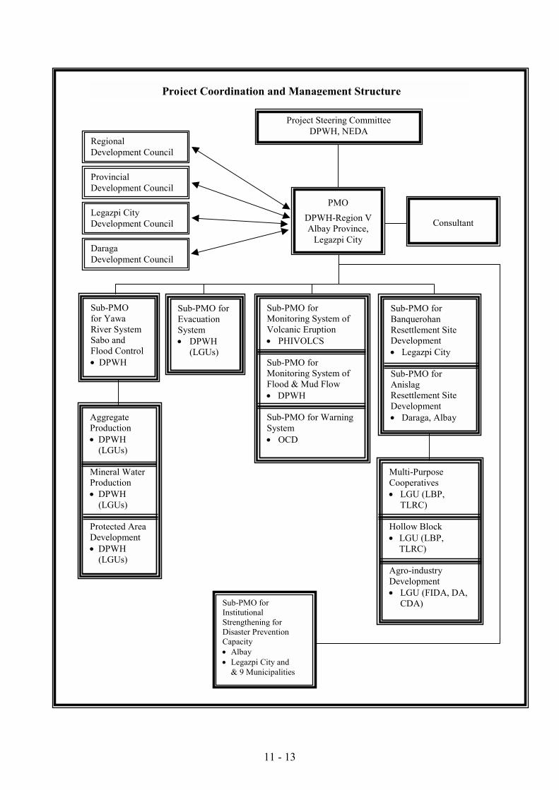
11 - 13
RegionalDevelopment Council
ProvincialDevelopment Council
Sub-PMO forInstitutionalStrengthening forDisaster PreventionCapacity! Albay! Legazpi City and
& 9 Municipalities
Sub-PMO forMonitoring System ofVolcanic Eruption! PHIVOLCS
Sub-PMO forMonitoring System ofFlood & Mud Flow! DPWH
Sub-PMO for WarningSystem! OCD
Sub-PMOfor YawaRiver SystemSabo andFlood Control! DPWH
Sub-PMO forBanquerohanResettlement SiteDevelopment! Legazpi City
Sub-PMO forAnislagResettlement SiteDevelopment! Daraga, Albay
Sub-PMO forEvacuationSystem! DPWH
(LGUs)
AggregateProduction! DPWH
(LGUs)
Mineral WaterProduction! DPWH
(LGUs)
Protected AreaDevelopment! DPWH
(LGUs)
Multi-PurposeCooperatives! LGU (LBP,
TLRC)
Hollow Block! LGU (LBP,
TLRC)
Agro-industryDevelopment! LGU (FIDA, DA,
CDA)
Legazpi CityDevelopment Council
DaragaDevelopment Council
PMODPWH-Region VAlbay Province,
Legazpi City
Consultant
Project Steering CommitteeDPWH, NEDA
Project Coordination and Management Structure
11 - 14
11.3 Implementation Schedule
Implementation schedule of priority projects and supporting projects andprograms is summarized in the following figures.
11.4 Project Cost Sharing by Implementing Organization
Project cost sharing will be made according to Implementation Arrangement.Tentative cost sharing plan for priority projects is given in the following tables.
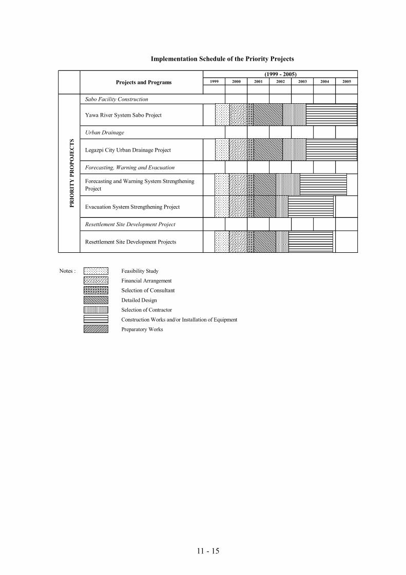
11 - 15
Implementation Schedule of the Priority Projects
1999 2000 2001 2002 2003 2004 2005
Sabo Facility Construction
Yawa River System Sabo Project
Urban Drainage
Legazpi City Urban Drainage Project
Forecasting, Warning and Evacuation
Forecasting and Warning System StrengtheningProject
Evacuation System Strengthening Project
Resettlement Site Development Project
Resettlement Site Development Projects
Notes : Feasibility Study
Financial Arrangement
Selection of Consultant
Detailed Design
Selection of Contractor
Construction Works and/or Installation of Equipment
Preparatory Works
PRIO
RIT
Y P
RO
POJE
CTS
(1999 - 2005)Projects and Programs
��������������������������������������������������������������������������������������������
����������������������������������������������
����������������������������������������������������������������������������������������������������������������������������������������������������������������������������������������
������������������������������������
������������������������������������������������������
������������������
������������������������������������������������������������������������
������������������������������������������������������������������
���������������������������������������������������������������������������������������������������������������������������
��������������������������������������������
��������������������������������������������������������������������
������������������������
������������������������������������������������������������������������������������������������
����������������������������������������������������������������������������������������
��������������������������������������������������������������������������������������������������������������������������������������������������������������������
���������������������������������������������
���������������������������������������������������
������������������
������������������������������������������������������������
������������������������������������������������������������������
������������������������������������������������������������������������������������������������������������������������������
���������������������������������������������
��������������������������������������������������������������������
������������������������
����������������������������������������������������������������������������
������������������������������������������������
������������������������������������������������������������������������������������������������������������������������������������������������������������
������������������������������������������������������������
��������������������������������������������������������������������
������������������������
����������������������������������������������������������������������������
����������������������������������������������������
����������������������������������������������������������������������������������������������������������������������������������������
11 - 16
Implementation Schedule of the Supporting Projects and Programs
1999 2000 2001 2002 2003 2004 2005
Supporting programs for Resettlers
Organization and Strengthening of Multi-purpose Cooperatives with Micro Credit
Hollow Block Production
Agro-industry Development (Abaca, Pilinutand Coco Coir)
Proposed Projects for Study Area Economic Development
Aggregate Production Plant Project
Mineral Water Development Project
Protected Area Development Project
Institutional Strengthening Project for Disaster Prevention
Provincial Disaster Management SystemStrengthening
Community-based Disaster ManagementStrengthening
Notes :
Financial Arrangement
Selection of Consultant
Detailed Design
Selection of Contractor
Construction Works and/or Installation of Equipment
Preparatory Works
Operation
(1999 - 2005)SU
PPO
RT
ING
AN
D IN
STIT
UT
ION
AL
PR
OJE
CT
S A
ND
PR
OG
RA
MS
Projects and Programs
����������������������������������������������������������������������������������������������������������������������������������������������������������������������������������������������������������������������������������������������������������������������������������������������������������������������������������������������������������������
����������������������������������������������������
��������������������������������������������������������������������������������������������������������������������������������������������������������������������������������������������������������������������������������
����������������������������������������������������������������
������������������������������������������������
��������������������������������������������������������������������������������
����������������������������������������������������������������������������������������
������������������������������������������������
����������������������������������������������������������������
��������������������������������������������
��������������������������������������������������������������������������������������������������������������������������������������������������������������������������������
��������������������������������������������
������������������������������������������������������������������������������������������������������������������������������������������������������������������������������������������������������������������������
������������������������
������������������������������������
��������������������������������������������������������������������������������������������������������������������������������������������������������������������
������������������������������������������������������������
����������������������������������������������������������������������������������������
������������������������������������
����������������������������������������������������������������������������������������������������������������
����������������������������������������������������������������������������������������������������������������������������������������������������������������������������������������������������������������������������������������������������������������������������������������������������������������������������������������������������������������
�������������������������������������������������������
���������������������������������������������
������������������������������������������������
��������������������������������������������
����������������������������������������������������������������������������������������������������������������������������������������������������������������������������������������������������������������
����������������������������������������
��������������������������������������������������������������������������������
����������������������������������������������������������������������������������������
������������������������������������������������
������������������������������������
����������������������������������������������������������������������������������������������������������������������������������������������������������������
��������������������������������������������������������������������������������
������������������������������������������������������������������������������������������������������������������������������������������������������������������������������������������������������������
������������������������������������������������������������������������������������������������������������������������������������������������������������������������������������������������������������������������
��������������������������������������������������������������������������������������������������������������������������������������������
����������������������������������������������������������������������������������������������������������������������������������������
������������������������������������������������������������������������������������������������������������������������������������������������������������������������������������
������������������������������������������������������������������������������������������
��������������������������������������������
��������������������������������������������
11 - 17
(Unit: Million PHP)F.C. L.C. DPWH Legazpi Daraga Total
City
1. Direct Cost 164.4 547.9 712.3 0.0 0.0 712.32. Government Administration Cost - 15.5 15.5 0.0 0.0 15.53. Engineering Services Cost 144.4 13.3 157.7 0.0 0.0 157.74. Land Acquisition - 35.3 0.0 25.4 9.9 35.35. Physical Contingency 30.9 61.2 92.1 0.0 0.0 92.1
339.7 673.2 977.6 25.4 9.9 1,012.96. Price Contingency 38.1 318.7 315.7 29.6 11.5 356.8
377.8 991.9 1,293.3 55.0 21.4 1,369.7
(Unit: Million PHP)F.C. L.C. DPWH Legazpi Total
City
1. Direct Cost 205.6 129.1 334.7 0.0 334.72. Government Administration Cost - 10.6 10.6 0.0 10.63. Engineering Services Cost 62.2 8.7 70.9 0.0 70.94. Land Acquisition - 15.7 0.0 15.7 15.75. Physical Contingency 26.8 16.4 43.2 0.0 43.2
294.6 180.5 459.4 15.7 475.16. Price Contingency 35.4 83.4 105.7 13.1 118.8
330.0 263.9 565.1 28.8 593.9
(Unit: Million PHP)F.C. L.C. DPWH PHIVOLCS OCD Total
1. Direct Cost 210.8 37.0 111.8 40.7 95.3 247.82. Government Administration Cost - 9.8 5.0 1.5 3.3 9.83. Engineering Services Cost 51.7 7.3 30.1 8.9 20.1 59.04. Physical Contingency 26.3 5.4 16.2 4.8 10.8 31.7
288.8 59.5 163.1 55.8 129.4 348.35. Price Contingency 33.8 25.3 30.1 8.9 20.1 59.1
322.6 84.8 193.2 64.6 149.5 407.4
Project Cost Sharing for Yawa River System Sabo Project
Description
Subtotal (1 - 5)
Description
Subtotal (1 - 5)
Total
Project Cost Sharing for Legazpi City Urban Drainage Project
Description
Total
Subtotal (1 - 5)
Total
Project Cost Sharing for Forecasting and Warning Strengthening Project
11 - 18
Project Cost Sharing for Evacuation System Strengthening Project(Unit: Million PHP)
F.C. L.C. DPWH *LGUs Total1. Direct Cost 0.0 291.9 260.8 31.1 291.92. Government Administration Cost - 9.1 8.5 0.6 9.13. Engineering Services Cost 34.4 6.2 37.8 2.8 40.64. Physical Contingency 3.4 30.7 31.7 2.4 34.1
37.8 337.9 338.8 36.9 375.75. Price Contingency 3.3 127.4 121.6 9.1 130.7
41.1 465.3 460.3 46.1 506.4*LGUs' cost sharing is proposed for Emergency Shelter and Livestock Sanctuary, LGUs refer to Legazpi City and 9 Municipalities. The detail is given in Table below.
Summary of Project Cost Sharing for Resettlement Site Development Project(Unit: Million PHP)
F.C. L.C. Legazpi Daraga TotalCity
1. Direct Cost 4.7 202.5 120.5 86.7 207.22. Government Administration Cost - 9.1 5.4 3.7 9.13. Engineering Services Cost 37.3 6.3 25.7 17.9 43.64. Physical Contingency 4.2 21.8 15.3 10.7 26.0
46.2 239.7 167.0 118.9 285.95. Price Contingency 4.0 90.0 55.5 38.5 94.0
50.2 329.7 222.4 157.5 379.9
Summary of Project Cost Sharing for Priority Projects(Unit: Million PHP)
DPWH PHIVOLCS OCD Legazpi Daraga *LGUs TotalCity
1. Yawa River System Sabo 1,293.3 55.0 21.4 1,369.72. Legazpi City Urban Drainage 565.1 28.8 593.93. 193.3 64.6 149.5 407.44. 460.4 4.1 1.2 40.7 506.45. 222.4 157.5 379.9
2,512.1 64.6 149.5 310.4 180.1 40.7 3,257.3
*LGUs refer to Municipalities of Camalig, Guinobatan, Ligao, Malilipot, Sto. Domingo and Tabaco
Evacuation System StrengtheningResettlement Site Development
Forecasting and Warning System
Description
Subtotal (1 - 5)
Total
Description
Total
Subtotal (1 - 5)
Total
Project
11 - 19
(Unit: Million PHP)
LGUBacacay Camalig Daraga Guinobatan Ligao Malilipot Malinao Sto.
DomingoTabaco Legazpi Total
LS-1 ES-2,LS-1 ES-1 ES-2,
LS-1ES-1,LS-1
ES-2,LS-1 LS-1 ES-3,
LS-1ES-3,LS-1
ES-2,LS-1
ES-16,LS-9
1. Direct Cost 1.93 3.33 1.70 3.33 2.63 3.33 1.93 4.02 4.02 3.33 29.552.
0.04 0.07 0.04 0.07 0.06 0.07 0.04 0.09 0.09 0.07 0.643. Engineering Services Cost 0.19 0.32 0.16 0.32 0.25 0.32 0.19 0.39 0.39 0.32 2.844. Physical Contingency 0.16 0.27 0.14 0.27 0.21 0.27 0.16 0.33 0.33 0.27 2.39
Subtotal (1 - 4) 2.32 3.99 2.03 3.99 3.15 3.99 2.32 4.82 4.82 3.99 35.425. Price Contingency 0.60 1.03 0.53 1.03 0.81 1.03 0.60 1.25 1.25 1.03 9.15
Total 2.91 5.02 2.56 5.02 3.97 5.02 2.91 6.07 6.07 5.02 44.57
ES- Emergency ShelterLS- Livestock sanctuary
Government AdministrationCost
Number of Shelter & Sanctuary
Summary of Project Cost Sharing for Evacuation Shelter and Livestock Sanctuary by LGUs
12 - 1
CHAPTER 12 OPERATION AND MAINTENANCE
12.1 Basic Concept
It is necessary to have an operations and maintenance plan before commencingconstruction/installation of equipment in order to achieve sustainable disasterprevention capacity. Thus, implementing organization for each project is requiredto provide an O&M plan before any disbursement begins. An annual review ofO&M activities and needs will be carried out by PMO.
12.1.1 Operation and Maintenance of Priority Projects
(1) Yawa River System Sabo Project
1) Scope of Works
Scope of works for O&M of sand pocket are assumed as follows:
! Maintenance dredging to remove deposit! Regular river survey including deposition in sand pocket! Monitoring river deposit mining! Regular inspection of sabo structure! Longitudinal profiling and Cross – sectioning survey
2) Dredging capacity
Dredging work by backhoe and dump truck is contemplated considering thephysical properties and the conditions of the sites.
(Excavation) - Bulldozer (22t) with ripper and Backhoe(Excavation and hauling) - Bulldozer and Backhoe(Hauling) - Backhoe
Adopted Equipment: Backhoe (Bucket Capacity 1.2m3)
Work capability of Backhoe for Dredging work is as follows. (Source: JapaneseConstruction and Equipment Handbook)
Earthwork Volume (Backhoe) = (3600"q"K"f"E)/Cm (m3/h)
q : Loading Volume/1 cycle (m3) q = 0.98"qo = 1.18m3
qo : Nominal Bucket Capacity 1.2m3
K : A coefficient of Bucket 0.98F : Bulking Factor 1E : Production Efficiency 0.6 (Normal Condition)Cm: Cycle Time 30 sec
12 - 2
Earthwork Volume : (3600*1.18*0.98*1*0.6)/30 = 83.3 (m3/h/car)
(Conveyance) - Dump truckAdopted Equipment: Dump truck (11t)E : Production Efficiency 0.9
(Normal Condition in case of Dump track)Transportation distance: Round way (3 - 4 km)(Maintenance of spoil bank yard) Bulldozer 11 t
Possible Dredging Volume per Round (Pawa-Burabod)
Equipment Number Dredging Capacity
Backhoe 1.2 m3 1 83.3 m3/h
Dump Track 11t 6 14.4m3/h×6=86.4 m3/h
Dredging Capacity/Party 83.3 m3/h
Possible Dredging Volume per Round (Anoling, Budiao)
Equipment Number Dredging Capacity
Backhoe 1.2 m3 1 83.3 m3/h
Dump Track 11t 3 32.0m3/h×3=96.0 m3/h
Dredging Capacity/Party 83.3 m3/h
As a result of the above, a work party in the Pawa-Burabod river and the Anoling,Budiao river consists of the following equipment.
The Pawa-burabod river: Backhoe 1, Dump Truck 6 and bulldozer 1
The Anoling and Budiao river: Backhoe 1, Dump Truck 3 and bulldozer 1
In case of working 8 hours a day, a work party which is composed of backhoe anddump truck is required the following total number of working days.
Work Volume of Dredging Work
Work Volume Number of PartyDredgingCapacity
(m3/h)
DredgingVolume
(m3)
Total Number ofDays
(days/year)
Pawa-Burabod1
(1 BH, 6 DT)83.7
(83.3×1)13,200 21
Anoling, Budiao1
(1 BH, 3 DT)83.7
(83.3×1)146,600 220
Total1
(2 BH, 9 DT)167.4 159,800 241
BH: BackhoeDT: Dump Track

12 - 3
3) Organization and Staffing
Required manpower is estimated as follows:
Required Number of Staff and Cost
PersonnelPawa-BurabodSand Pocket
Anoling, BudiaoSand Pocket
Labor Cost(PHP/day)
Site Supervisor 1 1 400
Administrator 1 1 300
Back hoe operator 1 1 350
Bulldozer operator or Pay Loader operator 2 1 350
Dump track driver 6 3 300
Guard 2 1 250
Total 13 8
4) Implementation of the Maintenance Works
The necessary maintenance works almost double the present dredging work doneby DPWH and the present capacity of DPWH might not be sufficient toaccommodate the works. The implementation is rather irregular and sporadicdepending on debris runoff and is preferable to be completed within short period.In the light of this, it is recommended that the implementation be carried out undera contract basis rather than the force account basis.
The estimated required budget for the maintenance works are 21.2 million PHP ayear.
(2) Legazpi City Urban Drainage Project
1) Scope of Works
The operation and maintenance works are required for the following structuresand facilities.
a. River channelsb. Pumping stationc. Retention ponds
In particular, it is of extreme importance that the emergency drainage equipmentof pumping station starts and is operable in situations such as during floods andheavy rain.
Therefore, the operation and maintenance works for pumping station extend to thefollowing categories to achieve the proper operation of pump drainage.
a. Facilities : Sustaining the reliabilityEasiness of operation
12 - 4
b. Operation : Assured operationSustaining capability of operators
c. Check and repair : Sustaining function of facilitiesPrevention of malfunction Repairing parts
d. Environmental conservation: Reduction of noise and vibrationReduction of air pollutionDisposal of garbageHarmonious facility to the surroundings
2) Operation of Pumping Facilities
The operation of Tibu and Macabalo Pumping Stations with floodgates, in case ofstorm rainfall, high tide or in combination is summarized hereafter.
When the sea water level reaches El. +1.61m which is HWL (High Water Level)measured at Legazpi Port, Tibu and Macabalo floodgates are closed to preventbackwater from the sea into the those rivers.
After closing the floodgates, the following procedures are applied to the pumpstations.
If the riverside water level is higher than the sea water level, the pump stationsstart operation until the sea water level becomes lower than HWL. Then, thefloodgates are open to drain river flow by gravity.
The operation periods of pumps at Tibu and Macabalo rivers is not set for certainmonths because a clear line cannot be drawn between rainy season and dry seasonin Albay Province. The pump stations are to be operational all year round.
3) Organization and Staffing for Operation and Maintenance
a. Organization
After completion of the project construction works, all the drainage facilities,including the Tibu and Macabalo Pumping Stations, will be transferred toDPWH, Region V which is designated the agency responsible for operationand maintenance of the completed project facilities.
DPWH, Region V will remain an important organization, coordinating otheragencies concerned and making higher level decisions.
For operation and maintenance, coordination with the Engineer's Office ofLegazpi City is important, particularly for the Tibu and Macabalo PumpingStations and their floodgates and retention ponds.
12 - 5
A telemeter or radio communication system is proposed to be established toachieve drainage operation using an integrated operation system.
Main activities for operation and maintenance are:
! Operation of the pumping station, floodgates and their operation! Seasonal maintenance/rehabilitation of dikes, revetments, retention pond,
etc.! Daily patrol along the rivers, drainage channels! Measurement and monitoring of rainfall, water level, flow discharge and
water quality! Compilation of data and information regarding flood and flood damage
b. Staffing
For the operation and maintenance of the project, the required number ofstaff will be as shown below.
Required Number of Staff at Tibu and Macabalo Pumping Stations
PersonnelMacabalo Pumping
StationTibu
Pumping Station
General Manager 1 -
Administrator 2 -
Technician (Electric) 2 1
Technician (Mechanical) 2 1
Operator 3 3
Office boy, Dump truck driver 4 2
Guard 3 3
Total 17 10
Note: General Manager and administrators are responsible for both pumping stations.
4) Operation and Maintenance Cost
The operation and maintenance costs and economic life for the project areconsidered in terms of economic cost as shown below.
Operation and Maintenance Cost and Economic Life for the Project
ItemRate for O&M
Cost(%)
Annual O&MCost
Maintenance/Repairing
Annual O&MCost Operation/Administration
Economic Life
1. Civil Works 0.3 30% 70% 50 yr
2. Gate Facilities 1.0 40% 60% 30 yr
3. Pump Facilities 2.0 50% 50% 15 yr
Note: Replacement cost is the same amount as initial investment cost.
12 - 6
(3) Forecasting and Warning System Strengthening and Evacuation Project
1) Target system of OMR
! The proposed system comprises the following systems:! Monitoring and forecasting system! Warning system! Evacuation system
The proposed monitoring and forecasting system comprises the following systemsfor the target hazards to be monitored:
! Eruption monitoring system! Typhoon monitoring system! Mud and debris flow monitoring system! Flood monitoring system
Existing system is adopted as it is for the typhoon monitoring and the prevailingOMR is supposed to be appropriate. And no additional input is necessary for thesystem.
An inter agency disaster information system is proposed as the core warningsystem in addition to the prevailing warning disseminating system. VHF radiotelephones are provided to enforce the communication between MDCC andBDCC.
Improvement of the existing evacuation center is proposed, and the emergencyshelters and the provision of a livestock sanctuary are proposed.
2) Scope of Works
Works requisite to the OMR incurred by the new proposals or proposal ofalterations are as follow:
Eruption monitoring
OMR for 3 telemetered seismograph and 1 repeater station, data processing unit, 1supervisory control and monitoring equipment, GPS and deformation assessmentsystem, elaboration and calibration of the assessment software
Mud and debris Flow monitoring
OMR for 14 telemetered rainfall gauging stations, 2 repeater stations and 1 systemsupervisory control and monitoring equipment, data processing unit andelaboration and calibration of the assessment software
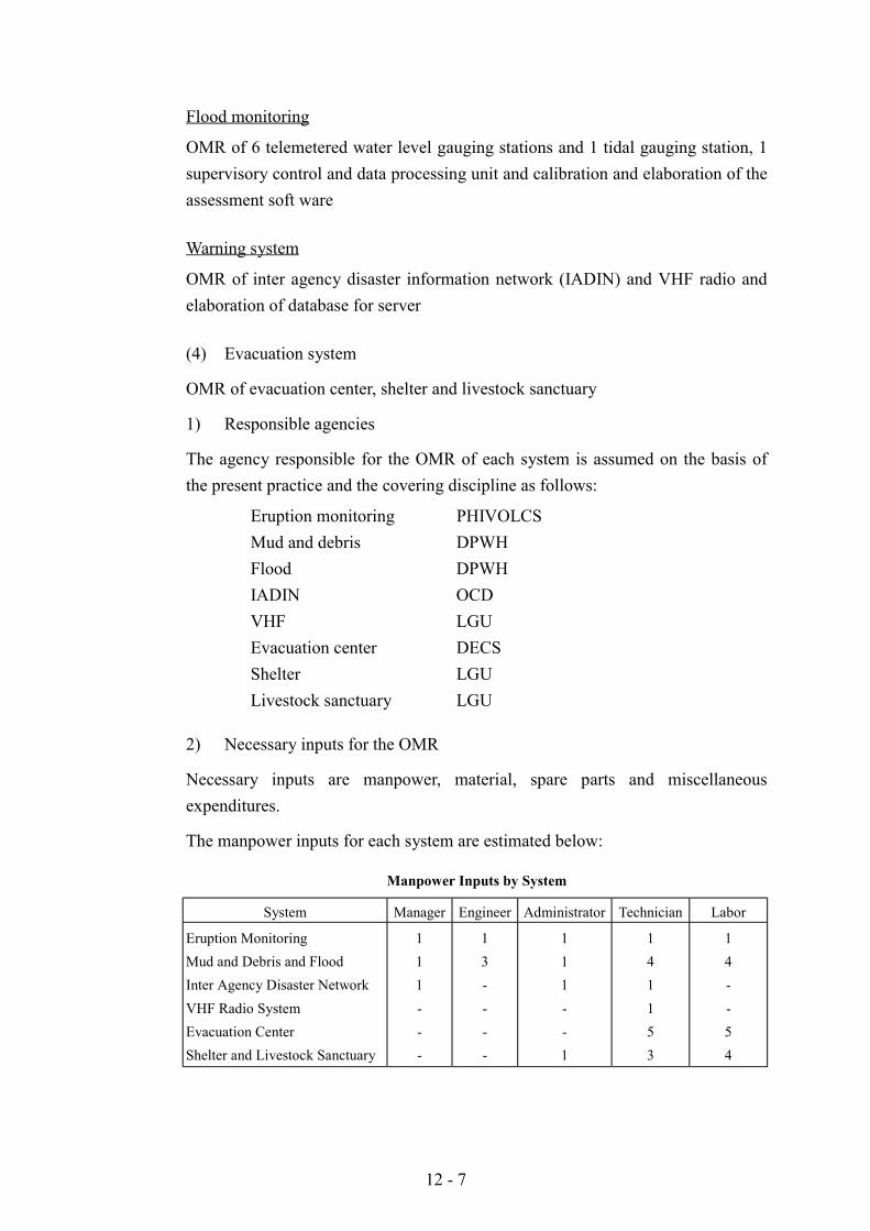
12 - 7
Flood monitoring
OMR of 6 telemetered water level gauging stations and 1 tidal gauging station, 1supervisory control and data processing unit and calibration and elaboration of theassessment soft ware
Warning system
OMR of inter agency disaster information network (IADIN) and VHF radio andelaboration of database for server
(4) Evacuation system
OMR of evacuation center, shelter and livestock sanctuary
1) Responsible agencies
The agency responsible for the OMR of each system is assumed on the basis ofthe present practice and the covering discipline as follows:
Eruption monitoring PHIVOLCSMud and debris DPWHFlood DPWHIADIN OCDVHF LGUEvacuation center DECSShelter LGULivestock sanctuary LGU
2) Necessary inputs for the OMR
Necessary inputs are manpower, material, spare parts and miscellaneousexpenditures.
The manpower inputs for each system are estimated below:
Manpower Inputs by System
System Manager Engineer Administrator Technician Labor
Eruption MonitoringMud and Debris and FloodInter Agency Disaster NetworkVHF Radio SystemEvacuation CenterShelter and Livestock Sanctuary
111---
13----
111--1
141153
14--54
12 - 8
The necessary work force is assumed including part time input.
Material input and spare parts requirement including miscellaneous expenditureare estimated to be as follow:
Monitoring system 9% of installation costWarning system 9% of installation costEvacuation center 0.1% of construction cost
3) OMR cost
The estimated OMR costs are as follow:
Forecasting and Warning system 28.7 million PHPEvacuation, shelter and L. sanctuary 1.0 million PHP
(5) Resettlement Site Development Project
1) Scope of Works
Maintenance and repair works of the public facilities in the resettlement site willbe carried out according to the following procedure and rules.
! Repair inspection of the public facilities within the site:! Reporting on the trouble and preparation of an inventory of the facilities to be
rehabilitated:! Identification of the authority in charge (depending on the kinds of facilities
and works needed, and their degrees in trouble): and! Implementation of the maintenance and/or repair works
The responsibilities for the respective maintenance and repair works will be madeas follows:
! Roads and pathways (LGUs/Resettlement Committee concerned):! Water Supply system (Local Water Districts):! Drainage System (LGUs/Resettlement Committee concerned):! Electric power supply system (ALECO):! Public buildings
a. School (DECS)b. Chapel (Resettlement Committee/Community)c. Public Hall (Resettlement Committee/Community)d. Health and day care center (LGU/ Resettlement Committee)e. Productivity center (Resettlement Committee/Cooperative)f. Multi-purpose warehouse (Resettlement Committee/Cooperative)g. Park and open space (Resettlement Committee/Community)
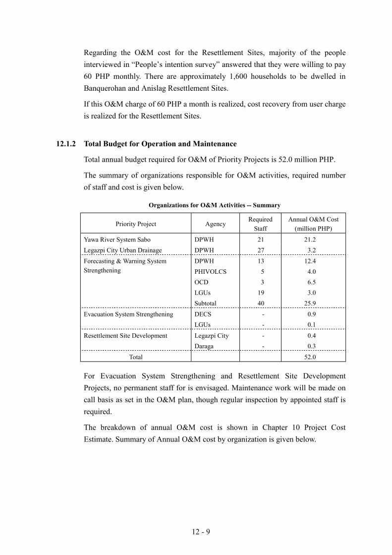
12 - 9
Regarding the O&M cost for the Resettlement Sites, majority of the peopleinterviewed in “People’s intention survey” answered that they were willing to pay60 PHP monthly. There are approximately 1,600 households to be dwelled inBanquerohan and Anislag Resettlement Sites.
If this O&M charge of 60 PHP a month is realized, cost recovery from user chargeis realized for the Resettlement Sites.
12.1.2 Total Budget for Operation and Maintenance
Total annual budget required for O&M of Priority Projects is 52.0 million PHP.
The summary of organizations responsible for O&M activities, required numberof staff and cost is given below.
Organizations for O&M Activities -- Summary
Priority Project AgencyRequired
StaffAnnual O&M Cost
(million PHP)
Yawa River System Sabo DPWH 21 21.2Legazpi City Urban Drainage DPWH 27 3.2
Forecasting & Warning SystemStrengthening
DPWHPHIVOLCSOCDLGUsSubtotal
1353
1940
12.44.06.53.0
25.9
Evacuation System Strengthening DECSLGUs
--
0.90.1
Resettlement Site Development Legazpi CityDaraga
--
0.40.3
Total 52.0
For Evacuation System Strengthening and Resettlement Site DevelopmentProjects, no permanent staff for is envisaged. Maintenance work will be made oncall basis as set in the O&M plan, though regular inspection by appointed staff isrequired.
The breakdown of annual O&M cost is shown in Chapter 10 Project CostEstimate. Summary of Annual O&M cost by organization is given below.
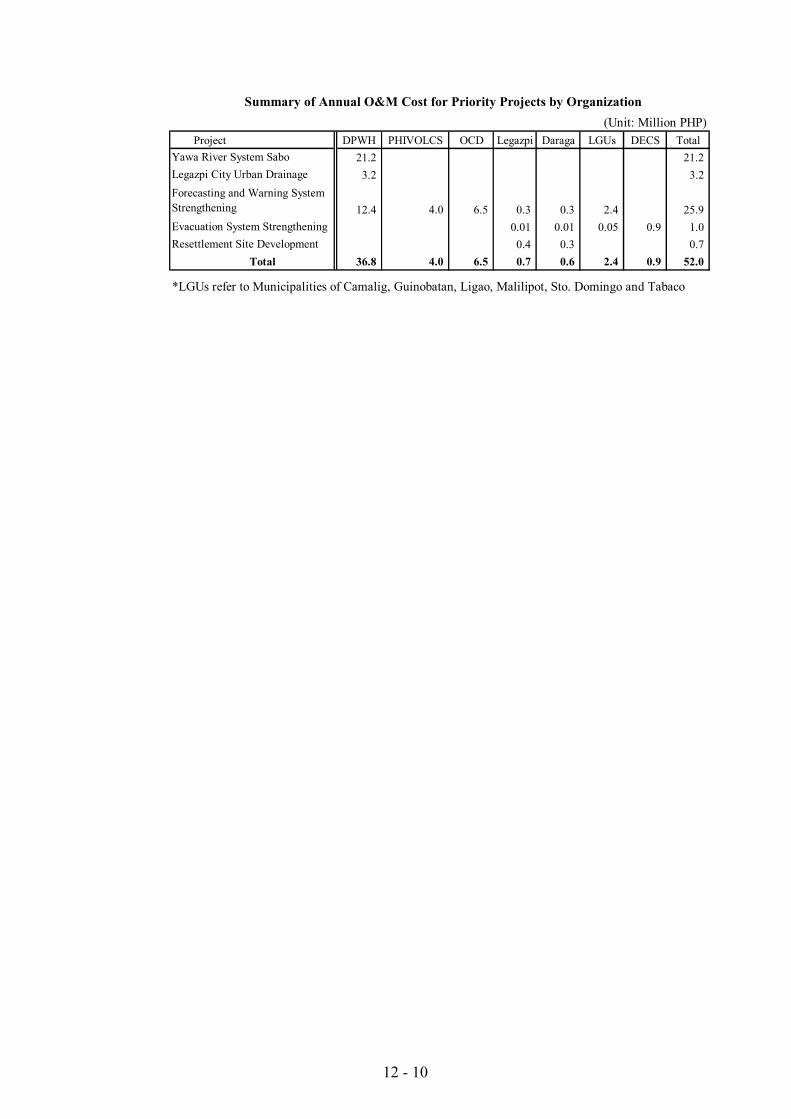
12 - 10
Summary of Annual O&M Cost for Priority Projects by Organization(Unit: Million PHP)
Project DPWH PHIVOLCS OCD Legazpi Daraga LGUs DECS Total21.2 21.2
3.2 3.2
12.4 4.0 6.5 0.3 0.3 2.4 25.90.01 0.01 0.05 0.9 1.0
0.4 0.3 0.7Total 36.8 4.0 6.5 0.7 0.6 2.4 0.9 52.0
*LGUs refer to Municipalities of Camalig, Guinobatan, Ligao, Malilipot, Sto. Domingo and Tabaco
Resettlement Site Development
Forecasting and Warning SystemStrengtheningEvacuation System Strengthening
Yawa River System Sabo Legazpi City Urban Drainage
13 - 1
CHAPTER 13 PROJECT EVALUATION
13.1 Economic Evaluation
13.1.1 Basic Conditions
The basic conditions for economic evaluations are as follows:
(1) Economic Evaluation is carried out by comparison between “With-the-Project” and Without-the-Project with regard to benefit and cost.
(2) Economic evaluation is conducted for Yawa River System Sabo Project,Legazpi City Urban Drainage Project and Resettlement Site DevelopmentProject for Banquerohan and Anislag
(3) The period for evaluation is assumed to include the period for theimplementation period for construction and 50 years including 30 years ofproject life after construction works.
(4) The social opportunity cost of capital in the Philippines is considered to be15%.
(5) The indicators of economic evaluation are “Economic Internal Rate of Return”(EIRR), “Benefit Cost Ratio”(B/C) and “Net Present Value”(NPV).
(6) The discount rate of social opportunity cost of capital of 15% is adopted tofigure out B/C and NPV.
13.1.2 Economic Benefit
(1) Yawa River System Sabo Project
In this project, Option 3 is taken into consideration for land use data. The benefitaccrued for this project is composed of (a) direct damages, (b) indirect damagesby mud and debris flow, and (c) development benefit. The values of damageableassets in the existing condition is shown in Table XXV 2.1.1 in Supporting Report(2) and the unit values of agricultural products and other assets are shown inTables XXV 2.1.2 in Supporting Report (2) and XXV 2.1.3 in Supporting Report(2), Chapter XXV.
Benefit generated by mud and debris flow control is defined as the expectedamount of average annual reduction of damages by the designed works.
Development benefit per annum for return period of 20-year is estimated in termsof difference or balance between revenue and cost generated from production. Theproductivity enhancement of agriculture was revised from two times in the MasterPlan to three times of the present productivity condition.
13 - 2
(2) Legazpi City Urban Drainage Project
From the economic viewpoint, inundation depth and damaged assets wereexamined on the basis of field survey conducted by the Study Team during thesecond field survey in the Philippines for flood prone area. The tables concerningthe field survey such as survey sheet, scale of samples, distribution of building inthe flood prone area of Legazpi City are shown in Tables XXV 2.1.4 to 2.1.10 inSupporting Report (2), Chapter XXV. The benefit generated from this project iscomposed of direct benefit and indirect benefit by flood.
The damage rates for each item vulnerable to flood damage are determined inaccordance with the inundation depth and duration. The damage rate byinundation depth for each kind of asset as the result of the field survey conductedby the JICA Study Team in the second field survey in the Philippines is shown inTable XXV 2.1.13 in Supporting Report (2), Chapter XXV. The estimates ofannual average flood damages by return period according to the procedurementioned above are shown in Table XXV 2.1.14 in Supporting Report (2),Chapter XXV.
(3) Resettlement Site Project
In Resettlement Site Project, the benefit generated from livelihood in resettledarea is composed of two sites for resettlements: (a) Banquerohan and (b) Anislag.The annual benefits generated from the project are considered to be the balance(net benefit) between revenue and cost by production. The annual cost andrevenue are shown in Table XXV 2.1.15 in Supporting Report (2), Chapter XXV.
13.1.3 Economic Cost
The project cost is converted from financial price to economic price. The basicconditions for conversions are the same as of the Master Plan. The disbursementschedule of the priority projects in economic price is shown in Table XXV 2.1.16in Supporting Report (2), Chapter XXV.
13.1.4 Economic Evaluation
The indicators for economic evaluation for the three priority projects are figuredout as follows.
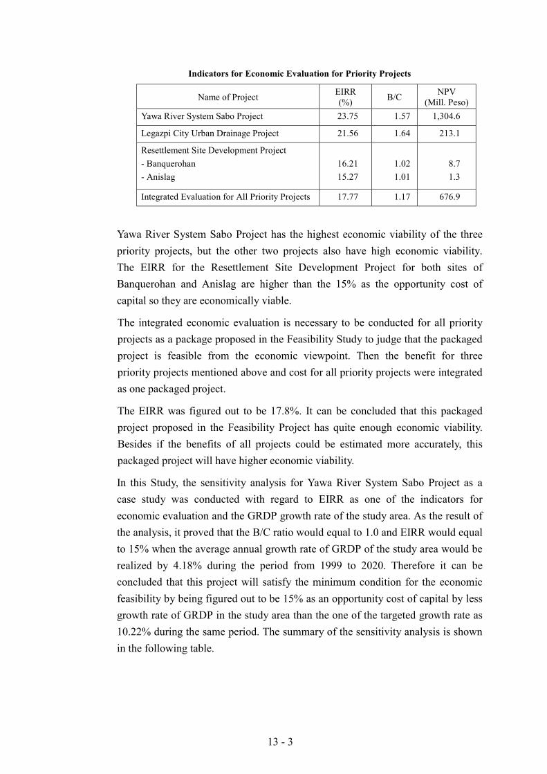
13 - 3
Indicators for Economic Evaluation for Priority Projects
Name of Project EIRR(%) B/C NPV
(Mill. Peso)Yawa River System Sabo Project 23.75 1.57 1,304.6
Legazpi City Urban Drainage Project 21.56 1.64 213.1
Resettlement Site Development Project- Banquerohan- Anislag
16.2115.27
1.021.01
8.71.3
Integrated Evaluation for All Priority Projects 17.77 1.17 676.9
Yawa River System Sabo Project has the highest economic viability of the threepriority projects, but the other two projects also have high economic viability.The EIRR for the Resettlement Site Development Project for both sites ofBanquerohan and Anislag are higher than the 15% as the opportunity cost ofcapital so they are economically viable.
The integrated economic evaluation is necessary to be conducted for all priorityprojects as a package proposed in the Feasibility Study to judge that the packagedproject is feasible from the economic viewpoint. Then the benefit for threepriority projects mentioned above and cost for all priority projects were integratedas one packaged project.
The EIRR was figured out to be 17.8%. It can be concluded that this packagedproject proposed in the Feasibility Project has quite enough economic viability.Besides if the benefits of all projects could be estimated more accurately, thispackaged project will have higher economic viability.
In this Study, the sensitivity analysis for Yawa River System Sabo Project as acase study was conducted with regard to EIRR as one of the indicators foreconomic evaluation and the GRDP growth rate of the study area. As the result ofthe analysis, it proved that the B/C ratio would equal to 1.0 and EIRR would equalto 15% when the average annual growth rate of GRDP of the study area would berealized by 4.18% during the period from 1999 to 2020. Therefore it can beconcluded that this project will satisfy the minimum condition for the economicfeasibility by being figured out to be 15% as an opportunity cost of capital by lessgrowth rate of GRDP in the study area than the one of the targeted growth rate as10.22% during the same period. The summary of the sensitivity analysis is shownin the following table.
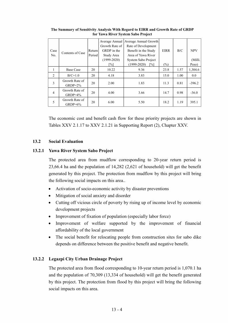
13 - 4
The Summary of Sensitivity Analysis With Regard to EIRR and Growth Rate of GRDPfor Yawa River System Sabo Project
CaseNo.
Contents of CaseReturnPeriod
Average AnnualGrowth Rate of
GRDP in theStudy Area
(1999-2020)[%]
Average Annual GrowthRate of DevelopmentBenefit in the StudyArea of Yawa RiverSystem Sabo Project(1999-2020) [%]
EIRR
(%)
B/C NPV
(Milli.Peso)
1 Base Case 20 10.22 9.36 23.8 1.57 1,304.6
2 B/C=1.0 20 4.18 3.83 15.0 1.00 0.0
3Growth Rate of
GRDP=2%20 2.00 1.83 11.3 0.81 -396.2
4Growth Rate of
GRDP=4%20 4.00 3.66 14.7 0.98 -36.0
5Growth Rate of
GRDP=6%20 6.00 5.50 18.2 1.19 395.1
The economic cost and benefit cash flow for these priority projects are shown inTables XXV 2.1.17 to XXV 2.1.21 in Supporting Report (2), Chapter XXV.
13.2 Social Evaluation
13.2.1 Yawa River System Sabo Project
The protected area from mudflow corresponding to 20-year return period is23,66.4 ha and the population of 14,282 (2,621 of household) will get the benefitgenerated by this project. The protection from mudflow by this project will bringthe following social impacts on this area..
! Activation of socio-economic activity by disaster preventions! Mitigation of social anxiety and disorder! Cutting off vicious circle of poverty by rising up of income level by economic
development projects! Improvement of fixation of population (especially labor force)! Improvement of welfare supported by the improvement of financial
affordability of the local government! The social benefit for relocating people from construction sites for sabo dike
depends on difference between the positive benefit and negative benefit.
13.2.2 Legazpi City Urban Drainage Project
The protected area from flood corresponding to 10-year return period is 1,070.1 haand the population of 70,309 (13,334 of household) will get the benefit generatedby this project. The protection from flood by this project will bring the followingsocial impacts on this area.
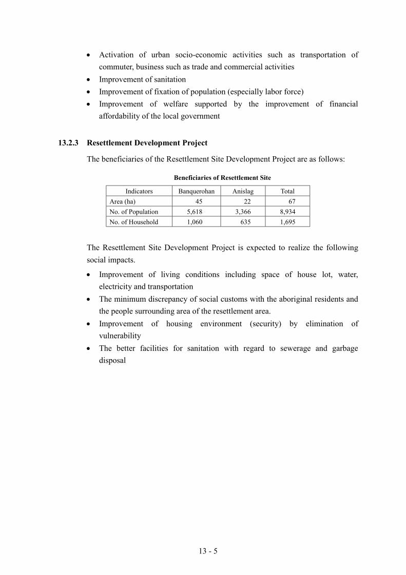
13 - 5
! Activation of urban socio-economic activities such as transportation ofcommuter, business such as trade and commercial activities
! Improvement of sanitation! Improvement of fixation of population (especially labor force)! Improvement of welfare supported by the improvement of financial
affordability of the local government
13.2.3 Resettlement Development Project
The beneficiaries of the Resettlement Site Development Project are as follows:
Beneficiaries of Resettlement Site
Indicators Banquerohan Anislag TotalArea (ha) 45 22 67No. of Population 5,618 3,366 8,934No. of Household 1,060 635 1,695
The Resettlement Site Development Project is expected to realize the followingsocial impacts.
! Improvement of living conditions including space of house lot, water,electricity and transportation
! The minimum discrepancy of social customs with the aboriginal residents andthe people surrounding area of the resettlement area.
! Improvement of housing environment (security) by elimination ofvulnerability
! The better facilities for sanitation with regard to sewerage and garbagedisposal
14 - 1
CHAPTER 14 THE PILOT PROJECT
14.1 The Objective of the Pilot Project
The objective of the execution of the Pilot Project, is to identify the key issues toestablish the forecasting, warning and evacuation systems in the Study Area.
14.2 Selection of Hazard
14.2.1 Candidate Hazard and Criteria of Selection
The hazard to be selected will be the one which is incurred by the eruption ofMayon Volcano and has the possibility to bring about considerable damages to theselected barangay. Such hazards are:
! Pyroclastic flow (including Nuee ardente)! Lava flow
! Ash fall
! Mud and debris flow
In order to select one hazard, the Study established evaluation criteria in the lightof the objectives and specifications of the Study as follows:
a. Hazard that will bring about a considerable damage should be selected.b. Hazard that frequently occurs should be selected.c. Hazard that occurs commonly all over the Study Area should be selected.d. Hazard forecasting system thereof will contribute much should be selected.
14.2.2 Evaluation and Selection of Hazard
Those hazards were evaluated and it was found that the damages incurred bypyroclastic flow and mud and debris flow stand out above others in the StudyArea. The former has claimed the most significant casualties repeatedly. In thecase of the eruption in 1993, 70 people were killed by the pyroclastic flow.Meanwhile, the latter has devastated fertile wealthy land that otherwise wouldenjoy rich harvest and deprived the farmer of their volition. Further, it is ratheroften that mud and debris flow causes casualties.
This same eruption resulted in seven persons killed by mud and debris flow.Meanwhile, lava flow devastate lands by its debris. However, the area devastatedis limited because of the high viscosity of the lava of Mayon volcano and mostly itdoes not reach to the fertile flat land. The high viscosity affects the movement of
14 - 2
lava flow. The slow movement of lava flow claims casualties seldom. Accordingto the record, ash fall could be seen at each occasion of eruption of Mayonvolcano. Ash fall of Mayon Volcano is, however, of small scale. So the damageincurred by it, is not significant. Along this line, it is concluded that either ofpyroclasic flow and mud and debris flow should be selected for the Pilot Project.
Most eruptions are accompanied by pyroclastic flow in the case of Mayon volcano.According to records, 90.5% of the eruptions have been accompanied bypyroclastic flow. The volcano is exceptionally active and has erupted with aninterval of about ten years recently. The occurrence frequency of mud and debrisflow is higher than that of eruption. A mud and debris flow is triggered by the firstheavy rain after an eruption. Additional flows can be triggered subsequentlyeach time there is heavy rainfall by a typhoon of monsoon. The first lahar thataccompanied the eruption in 1993 brought remarkable damage to the areas extendin the south-eastern slope of the mountain. No official record is available withregard to the occurrence of mud and debris flow, but to date it is confirmed that ithas occured at least 11 times since 1993.
The heavy rainfalls of Typhoon Monang in 1993, Akang and Rosing in1994 andMameng in 1995 caused lahar which affected 4,000 to 40,000 families. Mud anddebris flow is the most frequent disaster in the Study Area related to the eruptionof Mayon volcano.
The eruption of Mayon volcano is of Vulcanian type and pyroclastic flow mayhead for any direction of the slope. All the slope, accordingly, have the possibilityto suffer the damage by the pyroclastic flow although recent occurrences of thisdisaster seem to concentrate to south to southeastern areas. Mud and debris flowhave the possibility to occur through out the Study Area as well because the debrisof pyroclastic flow and lava flow, the source of mud and debris flow, might silt onthe slope arbitrarily as mentioned above. The old deposit might be weathered andliable to supply the source of mud and debris flow. Thus, mud and debris flow canbe acknowledged as the common disaster in the Study Area.
PHIVOLCS has monitored the activity of Mayon Volcano. It disseminateswarnings of five levels in accordance with the forecast through the assessment ofthe monitored data, seismicity, ash puff, crater glow, lava trickles, and others. Thetechnical standards adopted by PHIVOLOCS are considered to be of a sufficientlevel although strengthening of facility might be necessary.
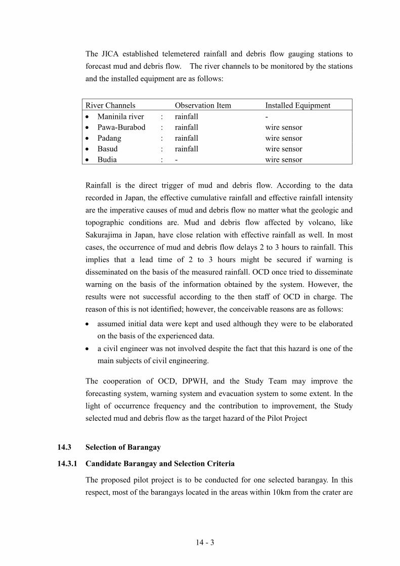
14 - 3
The JICA established telemetered rainfall and debris flow gauging stations toforecast mud and debris flow. The river channels to be monitored by the stationsand the installed equipment are as follows:
River Channels Observation Item Installed Equipment! Maninila river : rainfall -! Pawa-Burabod : rainfall wire sensor! Padang : rainfall wire sensor! Basud : rainfall wire sensor! Budia : - wire sensor
Rainfall is the direct trigger of mud and debris flow. According to the datarecorded in Japan, the effective cumulative rainfall and effective rainfall intensityare the imperative causes of mud and debris flow no matter what the geologic andtopographic conditions are. Mud and debris flow affected by volcano, likeSakurajima in Japan, have close relation with effective rainfall as well. In mostcases, the occurrence of mud and debris flow delays 2 to 3 hours to rainfall. Thisimplies that a lead time of 2 to 3 hours might be secured if warning isdisseminated on the basis of the measured rainfall. OCD once tried to disseminatewarning on the basis of the information obtained by the system. However, theresults were not successful according to the then staff of OCD in charge. Thereason of this is not identified; however, the conceivable reasons are as follows:
! assumed initial data were kept and used although they were to be elaboratedon the basis of the experienced data.
! a civil engineer was not involved despite the fact that this hazard is one of themain subjects of civil engineering.
The cooperation of OCD, DPWH, and the Study Team may improve theforecasting system, warning system and evacuation system to some extent. In thelight of occurrence frequency and the contribution to improvement, the Studyselected mud and debris flow as the target hazard of the Pilot Project
14.3 Selection of Barangay
14.3.1 Candidate Barangay and Selection Criteria
The proposed pilot project is to be conducted for one selected barangay. In thisrespect, most of the barangays located in the areas within 10km from the crater are
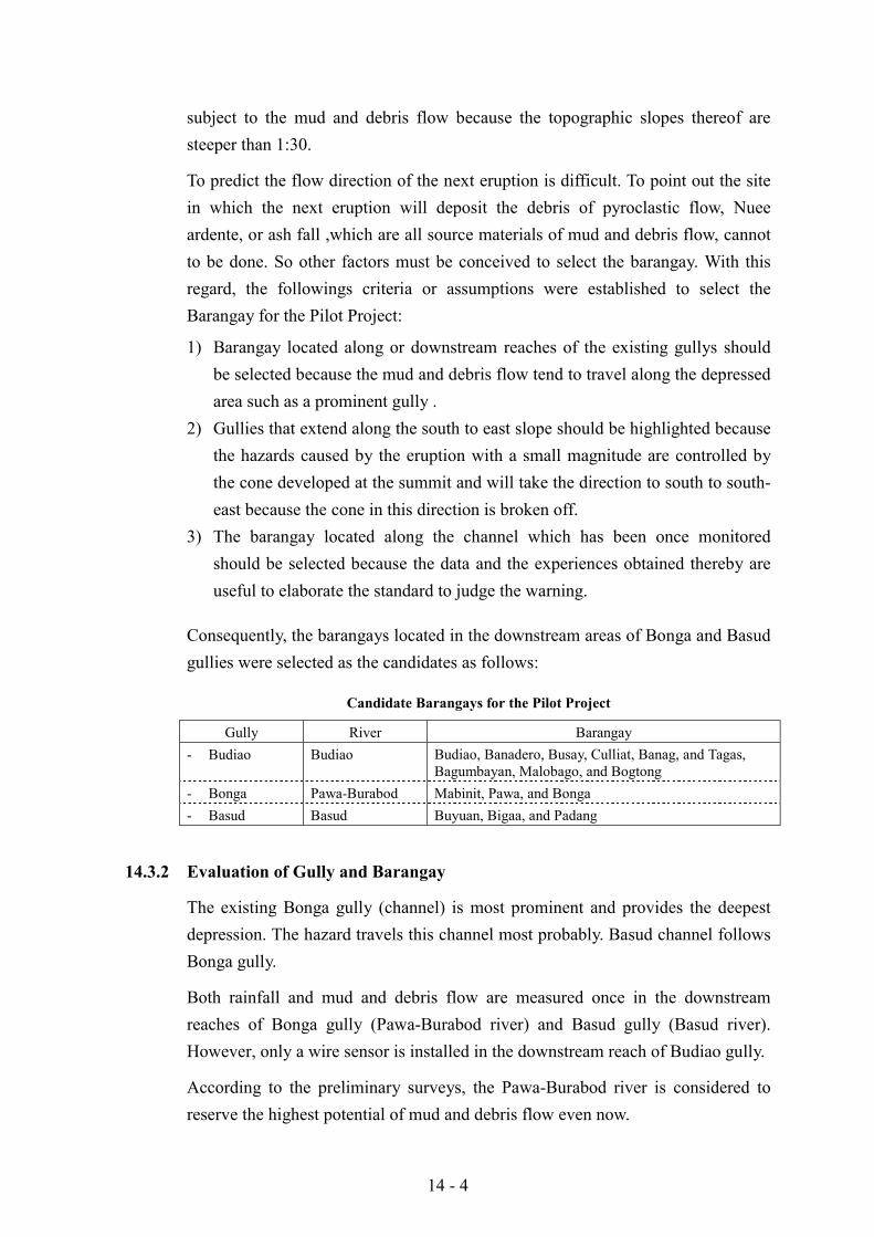
14 - 4
subject to the mud and debris flow because the topographic slopes thereof aresteeper than 1:30.
To predict the flow direction of the next eruption is difficult. To point out the sitein which the next eruption will deposit the debris of pyroclastic flow, Nueeardente, or ash fall ,which are all source materials of mud and debris flow, cannotto be done. So other factors must be conceived to select the barangay. With thisregard, the followings criteria or assumptions were established to select theBarangay for the Pilot Project:
1) Barangay located along or downstream reaches of the existing gullys shouldbe selected because the mud and debris flow tend to travel along the depressedarea such as a prominent gully .
2) Gullies that extend along the south to east slope should be highlighted becausethe hazards caused by the eruption with a small magnitude are controlled bythe cone developed at the summit and will take the direction to south to south-east because the cone in this direction is broken off.
3) The barangay located along the channel which has been once monitoredshould be selected because the data and the experiences obtained thereby areuseful to elaborate the standard to judge the warning.
Consequently, the barangays located in the downstream areas of Bonga and Basudgullies were selected as the candidates as follows:
Candidate Barangays for the Pilot Project
Gully River Barangay- Budiao Budiao Budiao, Banadero, Busay, Culliat, Banag, and Tagas,
Bagumbayan, Malobago, and Bogtong- Bonga Pawa-Burabod Mabinit, Pawa, and Bonga- Basud Basud Buyuan, Bigaa, and Padang
14.3.2 Evaluation of Gully and Barangay
The existing Bonga gully (channel) is most prominent and provides the deepestdepression. The hazard travels this channel most probably. Basud channel followsBonga gully.
Both rainfall and mud and debris flow are measured once in the downstreamreaches of Bonga gully (Pawa-Burabod river) and Basud gully (Basud river).However, only a wire sensor is installed in the downstream reach of Budiao gully.
According to the preliminary surveys, the Pawa-Burabod river is considered toreserve the highest potential of mud and debris flow even now.
14 - 5
In this accord, the Bonga gully (Pawa-Burabod river) was adopted as the target ofthe Pilot Project. Of the three barangays located in the Pawa-Burabod river basinthe Barangay Pawa extends over an area 9.5 to 10.5km from the crater. Theremaining two barangays are located at 8 km and are supposed to be more criticalwith regard to evacuation.
Barangay Mabinit is located at the right bank of the Pawa-Burabod river.Meanwhile Bonga is located at the left bank. The site reconnaissance surveyidentified that the right bank is more critical against mud and debris flow ascompared with the left bank. Consequently, Barangay Mabinit was selected asthe target Barangay.
14.4 First Pilot Project (Evacuation)
14.4.1 Scenario
The proposed first pilot project conducts forecasting and warning using thefacilities proposed by the Study. The project further conducts, evacuation of theselected Barangay: Mabinit. This forecasting, warning, and evacuation wereconducted in line with the following scenario.
a. 1st warning/ROCD
OCD monitor the rainfall in the watershed area of the Pawa-Burabod riveron the basis of the rainfall data transmitted from the rainfall gauging stationsestablished on the right bank of the Pawa-Burabod river and the left bank ofthe Buyuan river. The rainfall depth in the watershed area is to be estimatedautomatically in accordance with the program installed in the data processor.
In case the combination of accumulated rainfall and rainfall intensityexceeds the designated value, the processor will disseminate the firstwarning to the staff of OCD. The first warning is to arouse the attentions ofthe staff of the agency. The responsible staff of the agency must sit in frontof the monitor and watch the fluctuations of rainfall. Staff of ROCD willwatch and wait for further development in accordance with the manual.
b. 2nd warning/ROCD, PDCC, MDCC, BDCC and individual person
The next warning will be disseminated automatically if the rainfall increasefurther, either accumulated rainfall or intensity or both, and exceed thedesignated value. The second warning is to urge to start the preparations forevacuation. The information will be transmitted through the existing VHF
14 - 6
radio system to the provincial and city DCC from ROCD. The informationwill be transmitted to barangay DCC from CDCC through cellar telephone.The BDCC disseminates the 2nd warning to individual person in accordancewith the procedure stipulated in the Manual. Each family commence toprepare for evacuation in accordance with the procedure written in theManual.
c. 3rd warning/ROCD, PDCC, CDCC, BDCC and individual person
The 3rd warning is to be disseminated when the occurrence of hazard isconvinced. The information is to be transmitted from ROCD to PDCC,MDCC through VHF radio and to BDCC through cellar telephone. BDCCadvises the individual person to evacuate. ROCD, PDCC, and CDCC willmonitor evacuation through the communication system.
d. Release
When rainfall subsides and hazard is confirmed not to occur any more,release information is to be disseminated and all the staff and individualperson may resume the ordinary activity.
14.4.2 Preparation
(1) Confirmation of the Availability of Resources
1) Forecasting Facility
The availability of the forecasting facilities were confirmed through fieldreconnaissance survey at the gauging station sites and the monitoring site in theoffice of ROCD. The survey identified some defects to be repaired prior to theexecution of the pilot project. They are :
! Filter for rain gauge equipment should be replaced! Liquid of battery should be supplemented! Some IC board should be replaced! IC of printer should be replaced! Software for warning decision should be enhanced
2) Warning Facility
VHF radio equipment of ROCD, PDCC, CDCC, were all in good condition.Telephone, facsimile equipment of those agencies were all in satisfactorily

14 - 7
conditions as well. The survey revealed that no VHF radio is allocated inBarangay Mabinit.
3) Evacuation Facility
Legazpi city disaster coordinating council designated Albay Central School as theevacuation center for Barangay Mabinit. The evacuation center has sufficientroom with an area of 3,600m2 to accommodate around 800 evacuees. However,number of faucets, 9 and toilets, are not sufficient. The stocks of blankets, water,and food were just sufficient.
Barangay Mabinit designated five pickup points for evacuee. There are twopickup points without roof.
There are two evacuation routes: Kirikaw road on the west and Bonga road on theeast. Both roads have one lane with a width of less than 4m and are partiallypaved.
CDCC possesses two trucks to carry evacuees. CDCC reserve the right to borrowbuses and other vehicles owned by other agencies.
4) Organization and Staff
CDCC has established the procedure to organize Disaster Prevention Center at themost convenient site. The center will manage various disaster prevention teams asfollows:
! Evacuation! Warning! Relief! Security! Communication! Transportation! Medical! Information! Evacuation camp
DECS, PNP, CSWDO, and other related agencies are to collaborate with thecenter in addition to city, Barangay OCD, DPWH, PAGASA, and PHIVOLCS.Red cross, BSBI, and other NGO are to be involved with the center. The staff areobserved to be well trained.
14 - 8
Barangay has established BDCC comprising Purok leader. Information, warningare disseminated to each family by BDCC. It helps family to evacuate. However ithas not prepared an operation manual for emergency activity. The staff of BDCCare well trained.
(2) Preparation of Resources
The specification for rehabilitation of forecasting facilities were prepared. Thespecifications are duly submitted to JICA to purchase. Preparation to rent VHF radio equipment for Barangay was carried out.
! Manual for the emergency activity of BDCC was prepared.! Manual for the emergency activity of barangay people was prepared in visual
style (comics).! Manual for activity of ROCD against mud and debris flow was prepared.
(3) Preparation of Plan of Operation
Plan of operation was prepared to confirm the activities of the project. Thecontents of the plan of the operation are as follows;
! Background of the pilot project! Objective of the pilot project! Concept of the pilot project
- Scenario- Participants- Facility and equipment- Observation and analysis- Time table
! Schedule- The date of preparatory meeting- The date of execution: 27 Nov. 1999
(4) Meeting and Others
As the preparation works, official meetings were held three times with CDCC,BDCC, DPWH and the Study Team as follows:
! Sept. 10 1999! Nov. 19 1999! Nov. 26 1999
The main objectives of the meetings were to obtain the common understanding onthe procedures and the tasks by organization of the pilot project.
14 - 9
Workshop were held at the Barangay hall of Mabinit to explain the pilot projectfor the residents. BDCC,CDCC and the Study Team gave explanations. The otherobjective of the workshop was the explanation of emergency activity manual tothe local people.
Through the meeting, following amendments of the plan of operation were agreed:
! Quasi-warning is to be issued because the rehabilitation of the forecastingequipment is not to be completed before 27 November 1999.
! The site for the evacuation center is shifted from Albay Central School toGogon Elementary School because the former have been occupied by theevacuee due to the abnormal activity of Mayon volcano
14.4.3 Pilot Project
The pilot project is to introduce the system and equipment proposed by the MasterPlan to the selected area prior to the substantial installation to the whole targetarea. This comprises:
! Forecasting method and equipment! Forecasting software! Warning method and equipment! Operation manual for warning! Disaster prevention organization! Evacuation method and manual! Management of evacuation center
On 27 November 1999, a quasi-warning was issued to CDCC as scheduled. Anddisaster prevention works were activated by the various agencies and the residentsof Mabinit in line with the method and equipment proposed. The detailed timetable is briefed as follows:
06:58 Level-1 warning was issued to the ROCD staffROCD staff in charge stationed in the office for watch and wait
06:59 ROCD staff requested PAGASA weather forecast bulletin andconfirmed no climatic change
07:03 ROCD checked the availability of telephone, fax and VHF07:30 Availability were confirmed07:35 ROCD received quasi-level-2 warning07:40 Mud and debris bulletin07:45 Warning to CDCC and PDCC07:50 CDCC operation centre
14 - 10
07:55 CDCC issued warning to BDCCpreparation of evacuation center
08:00 setting up of center clinicsetting up of CSWD officesetting up of registration desk
08:13 BDCC meeting08:15 BDCC issued warning to residents upto 08:3008:25 Arrival of medical team to Mabinit08:35 Arrival of PNP to Mabinit08:40 Set up of field clinic08:41 ROCD received level-3 warning08:43 CDCC receive level-3 warning08:44 CDCC issue level-3 warning to BDCC08:45 CDCC dispatch vehicle to Mabinit
BDCC evacuation order to residentsResidents move to pickup point
09:00 Arrival of the first vehicle to MabinitThe final order of evacuation
09:15 Arrival of the last resident to the pickup point09:30 Arrival of the first evacuee to evacuation center09:35 Registration of evacuee09:40 Room assignment09:45 Orientation10:39 Arrival of the last batch of evacuee10:42 Distribution of food13:20 Release16:00 Return
The residents participating in the project was 507 persons from 174 families.The participation ratio is around 50% against the then population of 1,080 persons.Other agencies that participated were DECS, DPWH, PHIVOLCS, PAGASA,PDCC, and PDMO.
The prepared and used bulletin for warning of mud and debris flow is shown inTable 14.6.1. The location of the pilot project is shown in Figure 14.6.1.
14 - 11
14.4.4 Assessment
The proposed procedures and the prepared manuals functioned well in general.Their availability were confirmed through the simulation. There were a few eventsto be noted for the further enhancement as follows:
1) BDCC consumed 15 minutes to disseminate warning to each family bymeans of house to house visit although the 12 staffs in charge tried their best.The adopted method is reliable and not to be revised. In this connection, theproblem is the communication between BDCC and the disseminating staff toprovide the most updated information to the disseminator. All thedisseminators who will scatter all over the Barabngay should be equippedwith VHF radio terminal to receive the most updated information.
2) ROCD consumed 30 minutes to confirm the availability of thecommunication facility after receiving level-1 warning. This is becausePDCC staff was not stationed yet at that time. This implies that the firstwarning should be sent to a 24-hour manned site like a guard house toshorten the time to 10 minutes.
3) BDCC spent 20 minutes to order evacuation after receiving the warningfrom CDCC. This should be shortened by 10 minutes.
4) It took 30 minutes by vehicle for about 6 km. This is because only Kirikawroad was passable and it was too narrow to cross two vehicles (come and go).The necessary time is estimated to be 15 minutes if Bonga road is available.
5) A defect of Bonga road was found when the first batch of evacuees weredirected to the evacuation center. It is apparent that emergency response ofDPWH to inspect infrastructure and the emergency rehabilitationinfrastructure is important.
6) The time period for warning and evacuation may be shortened by 30 to 45minutes in total.
14 - 12
14.5 Second Pilot Project (Emergency Response by DPWH)
14.5.1 Scenario
The proposed second pilot project aimed to conduct a simulation of emergencyresponse in line with the Standard Operation Procedure (SOP) issued asDepartment Order 36/1988. Said emergency responses are based on forecastingand warning obtained from the system newly installed.
a. 1st warning
The DPWH region V monitors the rainfall in the Pawa-Burabod river basinon the basis of the telemetered rainfall data at Barangay Mabinit and Buyuan.The data processing unit of the telemeter issues the 1st level warning in casethe features of observed rainfall exceed the 1st level warning line (WL-1)generated by the processing unit. The warning is relayed to the staff incharge. The staff in charge inform the situation to the department toorganize Regional Disaster Coordinating Body (RDCB). The RDCB dulyestablish the Operation Center. The staff in charge sit in front of themonitor and watch and wait for the development as the monitoring team.
b. 2nd warning
The installed telemetered monitoring system issues 2nd warning in caserainfall exceeds the 2nd level warning line (WL-2) generated by theprocessing unit. The monitoring team relay the warning to the OperationCenter. The Operation Center dispatch survey teams to inspect theconditions of infrastructures. Survey team send the information on theconditions of infrastructure as the surveyed results. Technical planningstaff of the Operation Center design the measures of emergency response toreinforce the infrastructures. The Operation Center dispatch Repair andRestoration Team to the sites. The team repair the defects of infrastructures.The Operation Center disseminate the warning to the relevant MDCC andCDCC. It inform the warning to ROCD and PDCC as well.
c. 3rd warning
The Operation Center relay the 3rd warning to relevant DCCS and ROCD.The Center instructs all the staff and teams in accordance to respond to therequest by DCCS and ROCD.
14 - 13
d. Release
The Operation Center issue release statement and send it to the relevantDCCS and ROCD when the snake curve goes down to the zone below theWL-1 and the rainfall is considered to subside. It send the statement toeach team and staff dispatched to fields.
14.5.2 Preparation
(1) Confirmation of the Availability of Resources
1) Forecasting facility
The supervisory controller, monitoring unit, processing unit, and transmitter andreceiver were checked in the office of the DPWH region V. The receiver did notfunction well and was replaced to new one. The system was confirmed tofunction well including peripheral unit like the printer. The staffs of planningdivision were assigned as the staff in charge to monitor lahar. Thus monitoringteam of the Disaster Coordinating Body was established by three staff of theplanning division. The team made an investigation tour to Mabinit and Buyuanrainfall gauging stations on June 6 and 7. The functions of two gauging stationswere confirmed sound by the investigation.
2) Inspection facility
No vehicle and SSB telephone is available for the exclusive use for inspection.For the pilot project, the Study Team agreed to provide a vehicle for the inspection.However, one vehicle was made available by the district engineer’s office.
3) Repair facility
The Regional Equipment Service (RES) made one dump truck available for theuse of pilot project.
4) Organization and Staff
The participants of the pilot project are as follows:
Monitoring Team : Staff of planning divisionInvestigation Team : Staff of maintenance division
Staff of district engineers officeTechnical Planning Staff : Staff of planning division
Staff of district engineer’s officeRepair Team : Staff of equipment division
14 - 14
(2) Preparation of material
The main material for the pilot project is the fuel for the dump truck. Theapplication and approval to consume the fuel was made by the maintenancedivision.
(3) Meeting
The first workshop was held to understand the monitoring system on June 5.The discussion focussed on the theory adopted to the software of the dataprocessing unit. The participants thereto are the staff member of the monitoringteam of the DPWH and two staffs from ROCD.
The second workshop was held to confirm the scenario and staffing of the pilotproject on June 9. The plan of operation prepared by the Study Team andDPWH Regional Disaster Coordinating Body were materialized in the meeting.The participant are DPWH staffs assigned for Monitoring team, investigation teamand repair team including the staffs from the district engineer’s office.
14.5.3 Pilot Project
All the managing staff of the DPWH region-V were not available because of othermeeting and the establishing of the Operation Center could not be conducted onJune 13 when the second pilot project was held. The main activities of theproject are dispatching of inspection team and repair team to the sites. Thetimetable of the project are shown below:
09:15 Assumed to have warning level 1Monitoring team relayed the warningAssumed to have established Operation Center
09:50 Assumed to have warning level 2Monitoring team relayed the warningAssumed to have ordered inspection
10:00 Survey team started the office to barangay MabinitDistrict engineer’s office started to the barangay Mabinit
10:15 Arrival of survey team to the barangay and commencement ofinspection of evacuation road and the river channel
10:30 Information on the status was assumed to be sent by the surveyteam to the Operation Center. The survey team moved to thePadan river.
10:45 Decision was assumed to be made by the Operation Center and therepair team was dispatched to the site. The survey team moved toPadan.
14 - 15
11:00 The repair team arrived to the site.11:30 Repair was assumed to be completed at Mabinit and the repair team
was ordered to move to Padan.11:45 The Repair team arrived to Padan.12:00 Release statement was issued to all the team.
14.5.4 Assessment
The 3rd workshop was held to assess the pilot project on June 13. Theparticipants are members of the monitoring team, the survey team and the repairteam. The issues discussed therein are as follows:
! The alarm corresponding to the warning level 1 should be given to the sitewhere a man stationed for 24 hours like a guard house.
! The guard house should have a facility to communicate with the members ofthe monitoring team to relay the level 1 warning to the members.
! To have a service vehicle is preferable for the members of the monitoring teamto come to the office to monitor the system without delay.
! Survey team should prepare a manual to inspect infrastructures.! Vehicles with 4 wheel drive are indispensable to survey along the mountain
slope.! Communication tool is indispensable to survey and to inform the surveyed
results to the Operation Center.! Inventory of hydrology and structure are fundamental to plan the emergency
response.! Transfer of competence to utilize heavy equipment and to consume fuel
because the procedure in normal case is complicated and take time.! Materials should be reserved and stocked in a specific places for the use of
emergency.
15 - 1
CHAPTER 15 RECOMMENDATIONS
In the Study on Comprehensive Disaster Prevention around Mayon Volcanowhose target is set at the year 2020, the JICA Study Team formulated its MasterPlan and conducted the Feasibility Study on the priority projects selected in theMaster Plan. To implement the proposed priority projects, it is highlyrecommended that the Philippine Government undertake them in consideration ofthe following suggestions.
15.1 Earlier Implementation of the Priority Projects and Their Preparations
As a result of the Feasibility Study, all the priority projects and programsproposed by the JICA Study Team have been verified to be viable in terms ofeconomic and socio-environmental aspects.
Consequently, it is recommended for the GOP to promote these projects andprograms as soon as possible.
(1) Preparations for Implementation of the Projects and Programs
1) Formation of a Consensus through Discussions in the Related Communities
The disaster prevention projects and programs need to be implemented with theconsent of the government agencies concerned (both central and local) and therelated people. Prior to their implementation, it is advised to hold a series ofmeetings so as to make a consensus among all concerned.
2) Enlightenment of the People and Participation of the Communities
In addition to involvement of the government agencies, it is suggested to makemore Non-Government Organizations (NGOs) participate, and cooperate withthem in enlightening the people and communities.
3) Promotion of the People’s Self-preparedness
The disaster prevention activities depend on the willingness of the communitymembers. So, it is recommended to activate the voluntary participation of thepeople into disaster prevention activities.
15 - 2
(2) Appropriation of the Budget
1) Cost Sharing between Central Government and Local Government Units(LGUs)
Implementation of all priority projects and programs proposed in this Studyrequires a good deal of funds. In principle, the required costs should be shared inproportion to the amount of benefits to be received among the concerned.However, the fund raising capacity of LGUs is still limited and is much less thatof the communities. Considering such situation, it is indispensable to implementthese projects with an initiative of the central government to lead them tosuccessful realization. As far as this Study is concerned, the PhilippineGovernment agrees that the relevant LGUs share at least 10% of the total projectcost. In this regard, it is advised for both the central and local governments to sittogether with a view to discussing in detail about the sharing of costs and worksfor the respective related projects.
2) Financial Assistance from International Institution or Foreign Country
To complement the financial deficit of the central government, it may benecessary to have recourse to a financial assistance from the internationalfinancing institution or foreign donor country. As the aid conditions of the aboveinstitution or country vary from one to another and its preparatory procedure takestime, it is suggested to start to sound the financing possibility and make a requestat an early opportunity. In case that the Philippine Government makes a requestfor financing assistance, the following are supposed to be the basic conditions orrequirements for foreign financial assistance:
a. The project or program should be justified to be feasible.b. The project or program must be contributive to upgrading of the disaster
prevention capacity of the people or its community, and improvement of theirlivelihood.
c. In principle, the local portion in the project or program cost is to be borne bythe Philippine Government.
d. The Philippine Government commits the project implementation and it is to bedone with its initiative (even though it depends on the technical and financialassistance).
e. After completion of the project or program, its operations and maintenance isto be properly done by the Philippine side, particularly the LGUs and theImplementing Agency.
15 - 3
Among these five conditions, the items a. and b. have been confirmed in thisStudy. As for the remaining items from c. to e., JICA Team understands that suchconditions were understood and accepted by the Philippine side through a series ofexplanations and discussions with the high officials of the competent agencies.
(3) Establishment of the Implementation Structure
1) Institutional Arrangements
In the Philippines, the decrees provide for the duties and responsibilities of eachagency concerned with regard to the forecasting and warning of volcanic eruption,typhoon, and flood, but no legislation stipulates for the monitoring of the mud anddebris flow. It is therefore recommended to prepare an executive order, whichprescribes the mandate of DPWH as its main executor.
2) Creation of the Implementation Organization
As the priority projects and programs proposed comprise various works andactivities in both the structural and non-structural aspects, it is stronglyrecommended to establish an “integrated implementation system” which is able tomanage the whole structure, by entrusting the supervisory management power toDPWH.
3) Involvement of the Consultants including External Intellectuals
In view of a wide scope of works and activities of the proposed projects andprograms, several competent government agencies need to be involved inimplementing them. As to the general supervision of the whole projects andprograms implementation, it was confirmed in the Steering Committee meetingthat the DPWH assume a role of the main executor.
Since the DPWH has no experience yet in supervising and managing suchintegrated or packaged projects and programs, it is advised to hire a group ofQualified Consultants. It is, therefore, recommended to entrust them (as“ENGINEER” as prescribed in the FIDIC regulations) with full powers at theinitial stage of the project implementation. In proportion as the project progresses,the power will be gradually transferred to the main executor and all powers finallybelong to the designated authority. In this case, Consultants will be responsible forthe quality control of the works and also provide the advisory services on workschedule and financial control in the project management.
15 - 4
15.2 Immediate Execution of the Practicable Matters Using the AvailableResources
It is really to be appreciated that the Philippine Government makes every effort tocope with the disasters and ensure the better life of the people with the limitedresources. To improve further the current situations, it is proposed to undertake thefollowing to the utmost extent.
(1) Collection and Preparation of the Basic Data
The biggest bottleneck in the conduct of this Study was the lack of basic data andinformation, which are instrumental in clarifying the issues and formulating theplanning. The Master Plan study on comprehensive disaster prevention in theStudy Area is to be reviewed every ten years. To undertake this review, it isindispensable to do it based on the reliable data and accurate figures.Consequently, it is strongly suggested to consolidate the data management systemby collecting and storing properly the data and information regarding thefollowing:
1) Socio-economic Statistics
a. Population censusb. Socio-economic indicators in the Area (by Province, City/Municipality
and Barangay)c. Land use
2) Hydrological and River Flow Observations
a. RainfallsStream and water level gaugingRiver bed changes (longitudinal leveling and traversal sectional surveying)Excavation volume of the sediment
3) Disaster Records
a. Real situations in times of disaster occurrences regarding society,economy and physical conditions
b. Extent, intensity and impacts of the disaster (general situations of thedisaster, calamity and stricken areas, affected people, toll, amounts ofdamage by sector and category, number of days in economic abeyancedue to disaster, etc.)
15 - 5
c. Real state of evacuation (no. of evacuees by evacuation center,evacuation route, means of evacuation and its number , staying days inthe shelter, procurement and distribution of emergency stockpiles, etc.)
d. Calamity fund (amount by fund source, date of defrayal, details of actualdisbursement)
4) Records on Relocation and Resettlement
a. No. of resettlers by resettlement site, no. of permanent settlers, no. ofsettlers who abandoned the site, dates of settlement and departure
b. Inventory of resettlement site facilities and records on their rehabilitation
5) Records on Training and Drills
a. Practiced evacuation drillsb. Educational programs for the peoplec. Educational campaigns conducted for school pupils
6) Establishment of Database
(2) Strengthening of the Disaster Prevention Activities by the People, NGOs andVolunteers
In the Study Area, several NGOs have been actively involved in the disasterprevention activities and play a very important part not only in them but also inarea socioeconomic development. To promote further their effective participation,it is suggested to clarify the tie-up system with them, especially in the followingissues and fields of activities.
1) Surveying and Assessment of the Dangerous Areas and InformationNetworking
2) Awareness Raising of the People and Educational Campaign for the SchoolPupils
a. Utilization of the education curriculum and teaching manual prepared asa result of technical assistance of the Italian Government
b. Pictures (cartoons) and postersc. Essay contestd. Talks and presentations using photos, films, videos, etc.e. Others
3) Preparedness for Typhoon (clearing of drainage canals, cut-off of treebranches, etc.)
4) Reforestation5) Practice of the Disaster Prevention Drills
15 - 6
6) Publication of the Information Bulletins and Accomplishment Reports7) Others
(3) Inspection of the Disaster Prevention Facilities and Establishment ofEmergency Response System
1) Periodical Inspections of the Disaster Prevention Facilities and Recordings(forecasting and warning, evacuation routes, evacuation centers, etc.)
2) Rehabilitation of the Disaster Prevention Facilities and Recording of theEmergency Responses
(4) Preparation of the Manuals for Disaster Coping
(5) Reliable Transmission of the Forecasting and Warning Information
1) Clarification of the Duties and Responsibilitiesa. PAGASA : Forecasts on weather, typhoon and flood in a broad areab. PHIVOLCS: Eruptions of Mayon Volcanoc. DPWH: Mud & debris flows and flood in a local area
2) Accurate Data Collection and Forecasts3) Timely Transmission of the Information4) Periodical Inspections and O&M of the Facilities
(6) Grasp of the Land Use Situation
1) Survey for Grasping the Current and Future (Sustainable) Land Use2) Update of the Land Tax Inventory3) Preparation of the Land Use Maps and their Updating4) Preparation of the Future Land Use Plan5) Establishment of the Common Ownership System for the Collected Data and
Records