Embed Size (px)
Citation preview
HIGHWAY DESIGN MANUAL 80-1 June 21, 2013
CHAPTER 80 APPLICATION OF DESIGN
STANDARDS
Topic 81 - Project Development Overview
Index 81.1 - Philosophy
The Project Development process seeks to provide a
degree of mobility to users of the transportation
system that is in balance with other values. In the
development of transportation projects, social,
economic, and environmental effects must be
considered fully along with technical issues so that
final decisions are made in the best overall public
interest. Attention should be given to such
considerations as:
(a) Need to provide transportation for all users
(motorists, bicyclists, transit riders, and
pedestrians) of the facility and transportation
modes.
(b) Attainment of community goals and objectives.
(c) Needs of low mobility and disadvantaged
groups.
(d) Costs and benefits of eliminating or minimizing
adverse effects on natural resources,
environmental values, public services, aesthetic
values, and community and individual integrity.
(e) Planning based on realistic financial estimates.
(f) The cost, ease, and safety of maintaining
whatever is built.
Proper consideration of these items requires that a
facility be viewed from the perspectives of the user,
the nearby community, and larger statewide
interests. For the user, efficient travel, mode
selection, and safety are paramount concerns. At
the same time, the community often is more
concerned about local aesthetic, social, and
economic impacts. The general population,
however, tends to be interested in how successfully
a project functions as part of the overall
transportation system and how large a share of
available capital resources it consumes. Therefore,
individual projects must be selected for
construction on the basis of overall system benefits
as well as community goals, plans, and values.
Decisions must also emphasize the connectivity
between the different transportation modes so that
they work together effectively.
The goal is to increase person and goods throughput,
highway mobility and safety in a manner that is
compatible with, or which enhances, adjacent
community values and plans.
81.2 Highway Context
The context of a highway is a critical factor when
developing the purpose and need statement for a
project in addition to making fundamental design
decisions such as its typical cross section and when
selecting the design elements and aesthetic features
such as street furniture and construction materials.
Designing a highway that is sensitive to, and
respectful of, the surrounding context is critical for
project success in the minds of the Department and
our stakeholders.
A “one-size-fits-all” design philosophy is not
Departmental policy. Designers need to be aware of
and sensitive to land use, community context and the
associated user needs of the facility. In some
instances, the design criteria and standards in this
manual are based on the land use contexts in which
the State highway is located, for instance: large
population areas and downtowns in urban areas,
small rural towns and communities, suburban
commercial/residential areas, and rural corridors.
This approach ensures the standards are flexible, and
the approach allows and encourages methods to
minimize impacts on scenic, historic,
archaeological, environmental, and other important
resources.
Beyond their intended transportation benefits, State
highways can significantly impact the civic, social
and economic conditions of local communities.
Designing transportation facilities that integrate the
local transportation and land uses while making the
design responsive to the other needs of the
community support the livability of the community
and are usually a complementary goal to meeting the
transportation needs of the users of the State
highway system.
To do this successfully, the designer needs to have
an understanding of the area surrounding the
80-2 HIGHWAY DESIGN MANUAL
September 22, 2014
highway and the users of the highway, its function
within the regional and State transportation systems,
(which includes all transportation modes), and the
level of access control needed. To gain this
understanding, the designer must consult the
Transportation Concept Reports and work with the
planning division and the local agencies.
In this manual, the following concepts are used to
discuss the context of a highway:
• Place Type - the surrounding built and natural
environment;
• Type of Highway - the role the highway plays in
terms of providing regional or interregional
connectivity and local access; and,
• Access Control - the degree of connection or
separation between the highway and the
surrounding land use.
A “Main Street” design is not specific to a certain
place type, but is a design philosophy to be applied
on State highways that also function as community
streets. A “Main Street” design serves pedestrians,
bicyclists, businesses and public transit with
motorized traffic operating at speeds of 20 to
40 miles per hour. See the Department’s “Main
Street, California” document for more information.
81.3 Place Types
A place type describes the area’s physical
environment and the land uses surrounding the State
highway. The place types described below are
intentionally broad. Place types should be agreed
upon in partnership with all of the project
stakeholders; however, there likely may be more
than one place type within the limits of a project.
Ultimately, the place types selected can be used to
determine the appropriate application of the
guidance provided in this manual. These place type
definitions are independent of the Federal
government definitions of urban and rural areas. See
Title 23 United States Code, Section 13 for further
information.
Identifying the appropriate place type(s) involves
discussions with the project sponsors, ideally
through the Project Development Team (PDT)
process, and requires coordination with the land use
planning activities associated with the on-going
local and regional planning activities. Extensive
community engagement throughout both the
project planning and project development processes
helps to formulate context sensitive project
alternatives and transportation facilities that
coordinate with the local land uses.
The following place types are used in this manual:
(1) Rural Areas. Rural areas are typically sparsely
settled and developed. They can consist of
protected federal and State lands, agricultural
lands, and may include tourist and recreational
destinations. However, as rural lands transition
into rural communities, they can become more
developed and suburban and urban-like by
providing for a mixture of housing,
commercial, industrial and public institutions.
For the use of this manual, rural areas have
been subcategorized as Natural Corridors,
Developing Corridors and City/Town Centers
(Rural Main Streets).
(a) Natural Corridors. Typically, the desire in
these corridors is to preserve the natural
and scenic countryside while at the same
time provide transportation services to
support the travel and tourism that occurs
when visiting these locations. Examples of
this place type are: National/State Forests
and Parklands; agricultural lands with
scattered farm buildings and residences;
and, low density development. See Topic
109 for additional information.
(b) Developing Corridors. State highways
traveling through these lands tend to be
increasingly clustered with industrial,
commercial, and residential areas as they
lead into a rural city or town center. These
corridors can be a transition zone among
the aforementioned areas. Highways
associated with these locations help to
deliver tourists, but they also need to
support the local communities and their
local economies. In addition, these
highways also serve a role and should be
efficient at moving people and goods
between regions.
Industrial, commercial and retail buildings
tend to be located separately from housing
and are typically set back from the highway
with parking areas placed in
front. Truck traffic on these highways
HIGHWAY DESIGN MANUAL 80-3 December 30, 2015
tends to serve the needs of these industrial,
commercial and retail buildings; however,
there will be a component of the truck
traffic that is transporting their loads inter-
regionally. Therefore, corridors in areas
that are in transition may need to
accommodate design vehicles.
(c) City or Town Centers (Rural Main Streets).
State highways in this scenario are usually
a conventional main street through the
rural city or town, or they may be the only
main street. The use of the State highway
in this environment varies depending upon
the individual community, as does the mix
of buildings, services, businesses, and
public spaces. Transit is often present and
should be incorporated into the
transportation system as appropriate.
Transportation improvement projects on
these main street highways can be more
complicated and costly than similar
projects in more rural settings. A balance
usually needs to be maintained between the
needs of the through traffic and those of the
local main street environment. Thus,
analyzing the pedestrian and bicyclist
needs early in the development of the
project and then following through on the
agreements during the design of highway
projects in these locations can be especially
important. Accommodating the pedestrian
and bicyclist needs concurrently in projects
leads to greater efficiency in the use of
funding.
(2) Suburban Areas. Suburban areas lead into and
can completely surround urban areas. A
mixture of land uses is typical in suburban
areas. This land use mixture can consist of
housing, retail businesses and services, and
may include regional centers such as shopping
malls and other similar regional destinations;
which are usually associated with suburban
communities (cities and towns) that can be
connected with larger urban centers and cities.
Assessing the needs of pedestrians, bicyclists,
and transit users in concert with the vehicular
needs of motorists and truck drivers is
necessary during the project planning,
development and design of highway projects in
these locations. Accommodating all of these
needs concurrently into a project leads to
greater efficiency in the use of funding. For the
use of this manual, suburban areas have been
categorized as either Lower
Density/Residential Neighborhoods or Higher
Density/Regional Community Centers
(Suburban Main Streets).
(a) Lower Density / Residential Neighborh-
oods. State highways typically do not
cross through this place type. This place
type usually feeds users onto the State
highway system and is typically under the
jurisdiction of a local entity. State
highways, if they do interact with this place
type, usually just connect at the edges of
them where the pedestrians, bicyclists, and
motor vehicle operators integrate into the
highway system that includes transit
facilities.
(b) Higher Density / Regional Community
Centers (Suburban Main Streets). As
suburban areas grow they tend to merge
together into each other’s boundaries.
Growth in some locations can create
“Megacommunities.” While these
megacommunities seem to function as
individual cities, they typically have
multiple distinct community centers that
require highways with the capacity to serve
not only each center, but the center-to-
center traveler needs. These areas typically
require the State highway to serve not only
the originally urbanized area, but also the
newer suburban areas that have been
created where the housing, shopping and
employment opportunities are all centered.
Anticipating and accommodating growth
in this place type can be a challenge. State
and local governments, the business
community and citizens groups, and
metropolitan planning organizations all
need to agree on how to meet the
community needs, and at times the
interregional needs of the highway.
(3) Urban and Urbanized Areas. Urban areas
generally are the major population centers in
the State. Large numbers of people live in
80-4 HIGHWAY DESIGN MANUAL
December 30, 2015
these urbanized areas where growth is expected
to continue. Bicycling, transit, and walking are
important transportation modes in these areas
and as the facilities for pedestrians, transit and
bicyclists expand in these areas, the percentage
and number of travelers walking, using transit
and bicycling is also likely to increase. State
agencies and the local governmental entities,
the business community and citizens groups,
congestion management agencies and the
local/regional metropolitan planning
organization (MPO) need to all agree upon the
concept of the transportation facilities being
provided so that the community needs can be
met.
Urban areas are typically high-density
locations such as central business districts,
downtown communities, and major activity
centers. They have a full range of land uses and
are associated with a large diversity of
activities. For the use of place types in this
manual, urban areas have been categorized as
Lower Density Parklands and Residential
Neighborhoods and Higher Density Urban
Main Streets. Higher Density Urban Main
Streets have been further characterized as
Community Centers and Downtown Cores.
(a) Lower Density Parklands and Residential
Neighborhoods. Large numbers of people
live in these urbanized areas and bicycling,
transit and walking are important
transportation modes in these areas.
Parklands can enhance these
neighborhoods and parkland preservation
is a concern, as well as, access to support
travel and tourism to the parklands.
(b) High Density Urban Main Streets.
• Community Centers or Corridor.
Strategically improving the design and
function of the existing State highways
that cross these centers is typically a
concern. Providing transportation
options to enhancing these urban
neighborhoods that combine highway,
transit, passenger rail, walking, and
biking options are desirable, while they
also help promote tourism and
shopping.
• Downtown Cores. Similar to
community centers, much of the
transportation system has already been
built and its footprint in the community
needs to be preserved while its use may
need to be reallocated. Successfully
meeting the mobility needs of a major
metropolitan downtown core area
requires a balanced approach. Such an
approach is typically used to enhance
the existing transportation network’s
performance by adding capacity to the
highways, sidewalks, and transit
stations for all of the users of the
system, and/or adding such
enhancement features as HOV lanes,
BRT, walkable corridors, etc. Right of
way is limited and costly to purchase
in these locations. Delivery truck
traffic that supports the downtown core
businesses can also create problems.
The HEPGIS tool on the FHWA website is
available to determine if the project is in an
urban area. Urban areas are found on the
Highway Information tab of the tool.
81.4 Type of Highway
Much of the following terminology is either already
discussed in Chapter 20 or defined in Topic 62. The
additional information in this portion of the manual
is being provided to connect these terms with the
guidance that is being provided.
(1) Functional Classification. One of the first steps
in the highway design process is to define the
function that the facility is to serve. The two
major considerations in functionally classifying
a highway are access and throughput. Access
and mobility are inversely related; as access is
increased, mobility decreases. In the AASHTO
“A Policy on Geometric Design of Highways
and Streets”, highways are functionally
classified first as either urban or rural. The
hierarchy of the functional highway system
within either an urban or rural area consists of
the following:
HIGHWAY DESIGN MANUAL 80-5 July 2, 2018
• Principal arterial - main movement (high
mobility, limited access) Typically 4 lanes
or more;
• Minor arterial - interconnects principal
arterials (moderate mobility, limited access)
Typically 2 or 3 lanes with turn lanes to
benefit through traffic;
• Collectors - connects local roads to arterials
(moderate mobility, moderate access) with
few businesses; and,
• Local roads and streets - permits access to
abutting land (high access, limited
mobility).
The California Road System (CRS) maps are the
official functional classification maps approved by
Federal highway Administration. These maps show
functional classification of roads.
(2) Interstate Highways. The interstate highway
system was originally designed to be high-speed
interregional connectors and it is a portion of the
National Highway System (NHS). In urban and
suburban areas, a large percentage of vehicular
traffic is carried on the interstate highway
system, rather than on the local arterials and
streets.
(3) State Routes. The State highway system is
described in the California Streets and Highway
Code, Division 1, Chapter 2 and they are further
defined in this manual in Topic 62.3, Highway
Types which provides definitions for freeways,
expressways, and highways.
81.5 Access Control
Index 62.3 defines a controlled access highway and
a conventional highway. The level of access control
plays a part in determining the design standards that
are to be utilized when designing a highway. See
Index 405.6 for additional access control guidance.
81.6 Design Standards and Highway
Context
The design standards were initially established to
increase highway mobility and development,
promoting a State transportation system that
operated at selected levels of service consistent with
projected traffic volumes and highway
classification. Design standards revolved around
FHWA’s controlling criteria, evolving over time to
more fully consider adjacent community values,
local decisions making, and area context.
The design guidance and standards in this manual
have been developed with the intent of ensuring that:
• Designers have the ability to design for all
modes of travel (vehicular, bicycle, pedestrian,
truck and transit); and,
• Designers have the flexibility to tailor a project
to the unique circumstances that relate to it and
its location, while meeting driver expectation to
achieve established project goals.
Designers should balance the interregional
transportation needs with the needs of the
communities they pass through. The design of
projects should, when possible, expand the options
for biking, walking, and transit use. In planning and
designing projects, the project development team
should work with locals that have any livable
policies as revitalizing urban centers, building local
economies, and preserving historic sites and scenic
country roads. The “Main Streets: Flexibility in
Planning, Design and Operations” published by the
Department should be consulted for additional
guidance as should the FHWA publication
“Flexibility in Highway Design”.
Early consultation and discussion with the Project
Delivery Coordinator and the District Design
Liaison during the Project Initiation Document
(PID) phase is also necessary to avoid issues that
may arise later in the project development process.
Design Information Bulletin 78 “Design Checklist
for the Development of Geometric Plans” is a tool
that can be used to identify and discuss design
features that may deviate from standard.
Topic 82 - Application of Standards
82.1 Highway Design Manual Standards
(1) General. The highway design criteria and
policies in this manual provide a guide for the
engineer to exercise sound judgment in
applying standards, consistent with the above
Project Development philosophy, in the design
of projects. This guidance allows for flexibility
in applying design standards and documenting
design decisions that take the context of the

80-6 HIGHWAY DESIGN MANUAL
March 20, 2020
project location into consideration; which
enables the designer to tailor the design, as
appropriate, for the specific circumstances
while maintaining safety.
The design standards used for any project
should equal or exceed the minimum given in
the Manual to the maximum extent feasible,
taking into account costs (initial and life-
cycle), traffic volumes, traffic and safety
benefits, project goals, travel modes, facility
type, right of way, socio-economic and
environmental impacts, maintenance, etc.
Because design standards have evolved over
many years, many existing highways do not
conform fully to current standards. It is not
intended that current manual standards be
applied retroactively to all existing State
highways; such is neither warranted nor
economically feasible. However, when
warranted, upgrading of existing roadway
features such as guardrail, lighting,
superelevation, roadbed width, etc., should be
considered, either as independent projects or as
part of larger projects. A record of the decision
not to upgrade existing non-standard design
features are to be provided through the process
described in Index 82.2.
This manual does not address temporary
construction features. It is recognized that the
construction conditions encountered are so
diverse and variable that it is not practical to set
geometric criteria. Guidance for use of traffic
control devices for temporary construction
zones can be found in Part 6 – Temporary
Traffic Control of the California Manual on
Uniform Traffic Control Devices (California
MUTCD). Guidance for the engineering of
pavements in temporary construction zones is
available in Index 612.6. In this manual,
design standards and guidance are described as
follows (see Index 82.4 for other procedural
requirements):
(2) Absolute Requirements. Design guidance
related to requirements of law, policy, or
statute that do not allow exception are phrased
by the use of “must,” “is required,” “without
exception,” “are to be,” “is to be,” “in no
event,” or a combination of these terms.
(3) Controlling Criteria. The FHWA has
designated the following ten controlling
criteria for projects on the National Highway
System (NHS) as comprehensive design
standards which cover a multitude of design
characteristics, allowing flexibility in
application:
• Design Speed
• Lane Width
• Shoulder Width
• Horizontal Curve Radius
• Superelevation Rate
• Stopping Sight Distance
• Maximum Grade
• Cross Slope
• Vertical Clearance
• Design Loading Structural Capacity (non
geometric)
Design loading structural capacity criteria
applies to all NHS facility types. See the
Technical Publications – DES Manuals for
further information.
The remaining geometric criteria listed above
are applicable to the NHS as follows: (1) On
high-speed roadways (Interstate highways,
other freeways, and roadways with design
speeds of greater than or equal to 50 mph), all
the geometric criteria apply. The stopping sight
distance criteria applies to horizontal alignments
and vertical alignments except for sag vertical
curves; and (2) On low-speed roadways (non-
freeways with design speeds less than 50 mph),
only the design speed criteria applies.
The two speed categories stated above that
FHWA designates match the high- and low-
speed definitions in Index 62.8(13) when
considering that design speed and posted speed
are set in 5 mph increments.
The design standards related to the geometric
criteria are identified in Table 82.1A among
other important geometric standards in this
manual regardless of the design speed of the
HIGHWAY DESIGN MANUAL 80-7 July 2, 2018
roadway and whether or not the roadway is part
of the NHS.
(4) Standards. Design standards are those
considered most essential to achievement of
overall design objectives. Many pertain to
requirements of law or regulations such as
those embodied in the FHWA's ten controlling
criteria (see Index 82.1(3)). In addition to the
FHWA’s ten controlling criteria are “Caltrans-
only” standards that have been identified by
Caltrans as most essential pertaining to
requirements of State law, policy or objectives.
The design standards are shown in this manual
as either Boldface type (listed in Table 82.1A)
or Underlined type (listed in Table 82.1B) to
indicate the approval authority for nonstandard
design according to Index 82.2.
(5) Decision Requiring Other Approvals. There are
design criteria decisions that are not bold or
underlined text which require specific
approvals from individuals to whom such
decisions have been delegated. These
individuals include, but are not limited to,
District Directors, Project Delivery
Coordinators or their combination as specified
in this manual. These decisions should be
documented as the individual approving
desires.
(6) Permissive Standards. All guidance other than
absolute requirements, standards, or decisions
requiring other approvals, whether indicated by
the use of “should”, “may”, or “can” are
permissive.
(7) Other Caltrans Publications. In addition to the
design standards in this manual, see Index 82.7
for general information on the Department’s
traffic engineering policy, standards, practices
and study warrants.
Caution must be exercised when using other
Caltrans publications which provide guidelines
for the design of highway facilities, such as
HOV lanes. These publications do not
contain design standards; moreover, the
designs suggested in these publications do not
always meet Highway Design Manual
Standards. Therefore, all other Caltrans
publications must be used in conjunction with
this manual.
(9) Transportation Facilities Under the
Jurisdiction of Others. Generally, if the local
road or street is a Federal-aid route it should
conform to AASHTO standards; see Topic 308
– Cross Sections for Roads Under Other
Jurisdictions. Occasionally though, projects on
the State highway system involve work on
adjacent transportation facilities that are under
the jurisdiction of cities and counties. Some of
these local jurisdictions may have published
standards for facilities that they own and
operate. The guidance in this manual may be
applicable, but it was prepared for use on the
State highway system. Thus, when project
work impacts adjacent transportation facilities
that are under the jurisdiction of cities and
counties, local standards and AASHTO
guidance must be used in conjunction with this
manual to encourage designs that are sensitive
to the local context and community values.
Agreeing on which standards will be used
needs to be decided early in the project delivery
process and on a project by project basis.
82.2 Approvals for Nonstandard Design
(1) Boldface Standards. Design features or
elements which deviate from standards
indicated in boldface type require the approval
of the Chief, Division of Design. This approval
authority has been delegated to the District
Directors for projects on conventional
highways and expressways, and for certain
other facilities in accordance with the current
District Design Delegation Agreement.
Approval authority for design standards
indicated in boldface type on all other facilities
has been delegated to the Project Delivery
Coordinators except as noted in Table 82.1A
where: (a) the standard has been delegated to
the District Director, (b) the standards in
Chapters 600 through 670 requires the approval
of the State Pavement Engineer, and (c)
specifically delegated to the District Director
80-8 HIGHWAY DESIGN MANUAL
July 2, 2018
per the current District Design Delegation
Agreements and may involve coordination
with the Project Delivery Coordinator. See the
HQ Division of Design website for the most
current District Design Delegation
Agreements.
The current procedures and documentation
requirements pertaining to the approval process
for deviation from design standards indicated
in boldface type as well as the dispute
resolution process are contained in Chapter 21
of the Project Development Procedures Manual
(PDPM).
Design exception approval must be obtained
pursuant to the instructions in PDPM Chapter
9.
The Moving Ahead for Progress in the 21st
Century Act (MAP-21) of 2012 allowed
significant delegation to the states by FHWA to
approve and administer portions of the Federal-
Aid Transportation Program. MAP-21 further
allowed delegation to the State DOT’s and in
response to this a Stewardship and Oversight
Agreement (SOA) document between FHWA
and Caltrans was signed. The SOA outlines the
process to determine specific project related
delegation to Caltrans. In general, the SOA
delegates approval of deviations from design
standards related to the ten controlling criteria
on all Interstate projects whether FHWA has
oversight responsibilities or not to Caltrans.
Exceptions to this delegation would be for
projects of FHWA Division Interest, which are
determined on a project by project basis. See
Index 43.2 for additional information.
Consultation with FHWA should be sought as
early in the project development process as
possible. However, formal FHWA approval, if
applicable, shall not be requested until the
appropriate Caltrans representative has
approved the design decision document.
FHWA approval is not required for deviations
from "Caltrans-only" standards. Table 82.1A
identifies these “Caltrans-only” standards.
Where FHWA approval of a deviation from a
design standard is required, only cite the
standards that are identified by the FHWA as
ten controlling criteria, see Index 82.1(3).
For local facilities crossing the State right of
way see Index 308.1.
(2) Underlined Standards. The authority to
approve deviations from standards indicated in
underlined type has been delegated to the
District Directors. A list of these standards is
provided in Table 82.1B. Proposals for
deviations from these standards can be
discussed with the District Design Liaison
during development of the approval
documentation. The responsibility for the
establishment of procedures for review,
documentation, and long term retention of
approved design decisions from these
standards has also been delegated to the
District Directors.
(3) Decisions Requiring Other Approvals. The
authority to approve specific decisions
identified in the text are also listed in Table
82.1C. The form of documentation or other
instructions are provided as directed by the
approval authority.
(4) Permissive Standards. A record of deviation
from permissive standards and the disclosure of
the engineering decisions in support of the
deviation should be documented and placed in
the project file. This principle of
documentation also applies when following
other Division of Design guidance, e.g., Design
Information Bulletins and Design Memos. The
form of documentation and other instructions
on long term retention of these engineering
decisions are to be provided as directed by the
District approval authority.
(5) Local Agencies. Cities and counties are
responsible for the design decisions they make
on transportation facilities they own and
operate. The responsible local entity is
delegated authority to exercise their
engineering judgment when utilizing the
applicable design guidance and standards,
including those for bicycle facilities
established by Caltrans pursuant to the Streets
and Highways Code Sections 890.6 and 890.8
and published in this manual. For further
information on this delegation and the
delegation process, see the Caltrans Local
Assistance Procedures Manual, Chapter 11.
HIGHWAY DESIGN MANUAL 80-9 March 20, 2020
82.3 FHWA and AASHTO Standards and
Policies
The standards in this manual generally conform to
the standards and policies set forth in the AASHTO
publications, "A Policy on Geometric Design of
Highways and Streets" (2018) and "A Policy on
Design Standards-Interstate System" (2016). A
third AASHTO publication, the latest edition of the
"Roadside Design Guide", focuses on creating safer
roadsides. These three documents, along with other
AASHTO and FHWA publications cited in 23 CFR
Ch 1, Part 625, Appendix A, contain most of the
current AASHTO policies and standards, and are
approved references to be used in conjunction with
this manual.
AASHTO policies and standards, which are
established as nationwide standards, do not always
satisfy California conditions. When standards
differ, the instructions in this manual govern, except
when necessary for FHWA project approval
(Index 108.7, Coordination with the FHWA).
The use of publications and manuals that are
developed by organizations other than the FHWA
and AASHTO can also provide additional guidance
not covered in this manual. The use of such
guidance coupled with sound engineering judgment
is to be exercised in collaboration with the guidance
in this manual.
82.4 Mandatory Procedural Requirements
Required procedures and policies for which Caltrans
is responsible, relating to project clearances,
permits, licenses, required tests, documentation,
value engineering, etc., are indicated by use of the
word "must". Procedures and actions to be
performed by others (subject to notification by
Caltrans), or statements of fact are indicated by the
word "will".
82.5 Effective Date for Implementing
Revisions to Design Standards
Revisions to design standards will be issued with a
stated effective date. It is understood that all
projects will be designed to current standards unless
a design decision has been approved in accordance
with Index 82.2 or otherwise noted by separate
Design Memorandum.
On projects where the project development process
has started, the following conditions on the effective
date of the new or revised standards will be applied:
• For all projects where the PS&E has not been
finalized, the new or revised design standards
shall be incorporated unless this would impose
a significant delay in the project schedule or a
significant increase in the project engineering or
construction costs. The Project Delivery
Coordinator or individual delegated authority
must make the final determination on whether to
apply the new or previous design standards on a
project-by-project basis for roadway features.
• For all projects where the PS&E has been
submitted to Headquarters Office Engineer for
advertising or the project is under construction,
the new or revised standards will be
incorporated only if they are identified in the
Change Transmittal as requiring special
implementation.
For locally-sponsored projects, the Oversight
Engineer must inform the funding sponsor within 15
working days of the effective date of any changes in
design standards as defined in Index 82.2.
82.6 Design Information Bulletins and
Other Caltrans Publications
In addition to the design standards in this manual,
Design Information Bulletins (DIBs) establish
policies and procedures for the various design
specialties of the Department that are in the Division
of Design. Some DIBs may eventually become part
of this manual, while others are written with the
intention to remain as design guidance in the DIB
format. References to DIBs are made in this manual
by the “base” DIB number only and considered to be
the latest version available on the Department
Design website. See the Department Design website
for further information concerning DIB numbering
protocol and postings.
Caution must be exercised when using other
Caltrans publications, which provide guidelines for
the design of highway facilities, such as HOV lanes.
These publications do not contain design standards;
moreover, the designs suggested in these
publications do not always meet Highway Design
Manual Standards. Therefore, all other Caltrans
publications must be used in conjunction with this
manual.
80-10 HIGHWAY DESIGN MANUAL
July 2, 2018
82.7 Traffic Engineering
The Division of Traffic Operations maintains
engineering policy, standards, practices and study
warrants to direct and guide decision-making on a
broad range of design and traffic engineering
features and systems, which are provided to meet the
site-specific safety and mobility needs of all
highway users.
The infrastructure within a highway or freeway
corridor, segment, intersection or interchange is not
“complete” for drivers, bicyclists and pedestrians
unless it includes the appropriate traffic control
devices; traffic safety systems; operational features
or strategies; and traffic management elements and
or systems. The presence or absence of these traffic
elements and systems can have a profound effect on
safety and operational performance. As such, they
are commonly employed to remediate performance
deficiencies and to optimize the overall performance
of the “built” highway system.
For additional information visit the Division of
Traffic Operations website at
http://www.dot.ca.gov/trafficops/
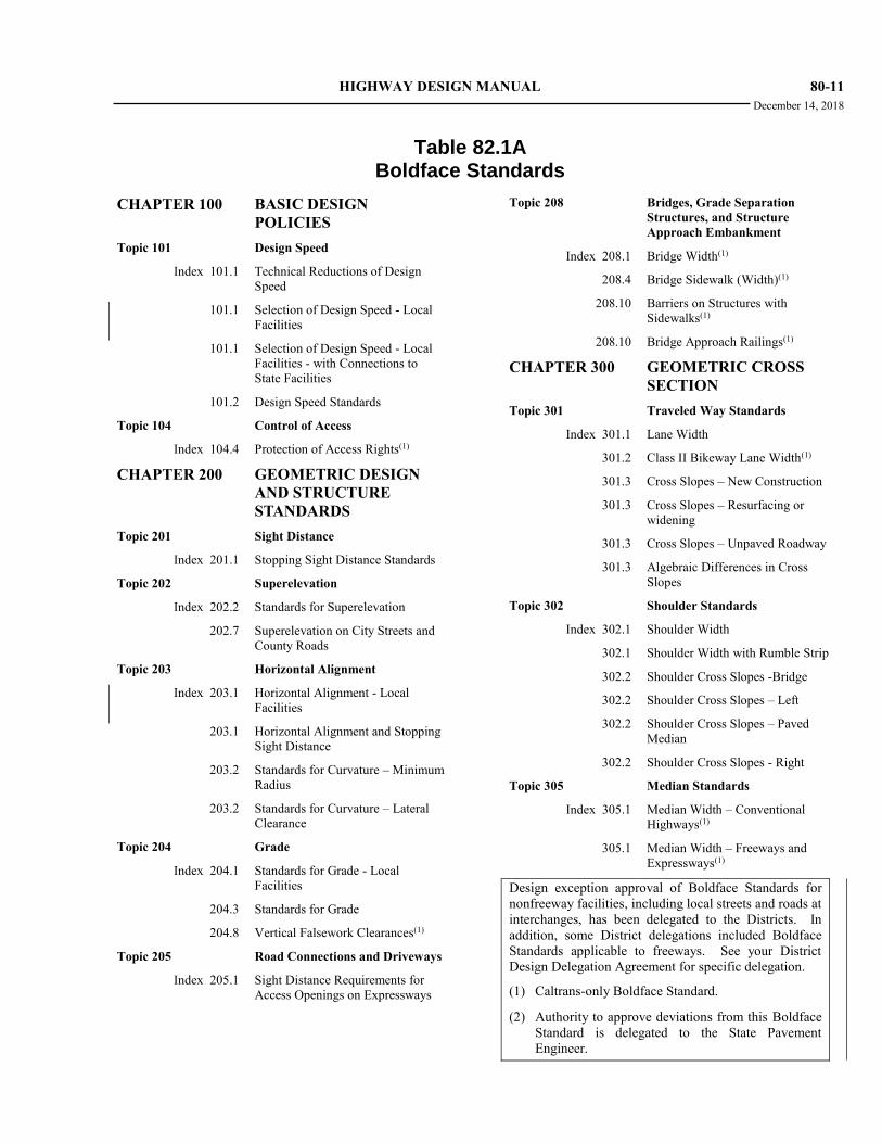
HIGHWAY DESIGN MANUAL 80-11 December 14, 2018
Table 82.1A
Boldface Standards
CHAPTER 100 BASIC DESIGN
POLICIES
Topic 101 Design Speed
Index 101.1 Technical Reductions of Design
Speed
101.1 Selection of Design Speed - Local
Facilities
101.1 Selection of Design Speed - Local
Facilities - with Connections to
State Facilities
101.2 Design Speed Standards
Topic 104 Control of Access
Index 104.4 Protection of Access Rights(1)
CHAPTER 200 GEOMETRIC DESIGN
AND STRUCTURE
STANDARDS
Topic 201 Sight Distance
Index 201.1 Stopping Sight Distance Standards
Topic 202 Superelevation
Index 202.2 Standards for Superelevation
202.7 Superelevation on City Streets and
County Roads
Topic 203 Horizontal Alignment
Index 203.1 Horizontal Alignment - Local
Facilities
203.1 Horizontal Alignment and Stopping
Sight Distance
203.2 Standards for Curvature – Minimum
Radius
203.2 Standards for Curvature – Lateral
Clearance
Topic 204 Grade
Index 204.1 Standards for Grade - Local
Facilities
204.3 Standards for Grade
204.8 Vertical Falsework Clearances(1)
Topic 205 Road Connections and Driveways
Index 205.1 Sight Distance Requirements for
Access Openings on Expressways
Topic 208 Bridges, Grade Separation
Structures, and Structure
Approach Embankment
Index 208.1 Bridge Width(1)
208.4 Bridge Sidewalk (Width)(1)
208.10 Barriers on Structures with
Sidewalks(1)
208.10 Bridge Approach Railings(1)
CHAPTER 300 GEOMETRIC CROSS
SECTION
Topic 301 Traveled Way Standards
Index 301.1 Lane Width
301.2 Class II Bikeway Lane Width(1)
301.3 Cross Slopes – New Construction
301.3 Cross Slopes – Resurfacing or
widening
301.3 Cross Slopes – Unpaved Roadway
301.3 Algebraic Differences in Cross
Slopes
Topic 302 Shoulder Standards
Index 302.1 Shoulder Width
302.1 Shoulder Width with Rumble Strip
302.2 Shoulder Cross Slopes -Bridge
302.2 Shoulder Cross Slopes – Left
302.2 Shoulder Cross Slopes – Paved
Median
302.2 Shoulder Cross Slopes - Right
Topic 305 Median Standards
Index 305.1 Median Width – Conventional
Highways(1)
305.1 Median Width – Freeways and
Expressways(1)
Design exception approval of Boldface Standards for
nonfreeway facilities, including local streets and roads at
interchanges, has been delegated to the Districts. In
addition, some District delegations included Boldface
Standards applicable to freeways. See your District
Design Delegation Agreement for specific delegation.
(1) Caltrans-only Boldface Standard.
(2) Authority to approve deviations from this Boldface
Standard is delegated to the State Pavement
Engineer.
80-12 HIGHWAY DESIGN MANUAL
March 20, 2020
Table 82.1A
Boldface Standards (Cont.)
Topic 307 Cross Sections for State Highways
Index 307.2 Shoulder Standards for Two-lane
Cross Sections for New
Construction
Topic 308 Cross Sections for Roads Under
Other Jurisdictions
Index 308.1 Cross Section Standards for City
Streets and County Roads without
Connection to State Facilities
308.1 Minimum Width of 2-lane Over-
crossing Structures for City Streets
and County Roads without
Connection to State Facilities(1)
308.1 Cross Section Standards for City
Streets and County Roads with
Connection to State Facilities
308.1 Two-Lane Local Road Lane Width
for City Streets and County Roads
within Interchange
308.1 Multi-Lane Local Road Lane Width
for City Streets and County Roads
within Interchange
308.1 Shoulder Width Standards for City
Streets and County Roads Lateral
Obstructions
308.1 Shoulder Width Standards for City
Streets and County Roads with
Curbs and Gutter
308.1 Minimum Width for 2-lane
Overcrossing at Interchanges(1)
Topic 309 Clearances
Index 309.1 Horizontal Clearances and Stopping
Sight Distance
309.1 Horizontal Clearances(1)
309.1 High Speed Rail Clearances –
Minimum Shoulder Width
309.2 Vertical Clearances - Minor
Structures
309.2 Vertical Clearances - Rural and
Single Interstate Routing System
309.3 Horizontal Tunnel Clearances(1)
309.3 Vertical Tunnel Clearances
309.4 Lateral Clearance for Elevated
Structures(1)
309.5 Structures Across or Adjacent to
Railroads - Vertical Clearance
Topic 310 Frontage Roads
Index 310.1 Frontage Road Width Cross Section
CHAPTER 400 INTERSECTIONS AT
GRADE
Topic 404 Design Vehicles
Index 404.2 Design Vehicle–Traveled Way(1)
Topic 405 Intersection Design Standards
Index 405.2 Left-turn Channelization - Lane
Width
405.2 Left-turn Channelization - Lane
Width – Restricted Urban
405.2 Two-way Left-turn Lane Width
405.3 Right-turn Channelization – Lane
and Shoulder Width
CHAPTER 500 TRAFFIC
INTERCHANGES
Topic 501 General
Index 501.3 Interchange Spacing(1)
Topic 502 Interchange Types
Index 502.2 Isolated Off-Ramps and Partial
Interchanges(1)
502.3 Route Continuity(1)
Topic 504 Interchange Design Standards
Index 504.2 Location of Freeway Entrances &
Exits(1)
504.2 Ramp Deceleration Lane and “DL”
Distance(1)
Design exception approval of Boldface Standards for
nonfreeway facilities, including local streets and roads at
interchanges, has been delegated to the Districts. In
addition, some District delegations included Boldface
Standards applicable to freeways. See your District
Design Delegation Agreement for specific delegation.
(1) Caltrans-only Boldface Standard.
(2) Authority to approve deviations from this Boldface
Standard is delegated to the State Pavement
Engineer.
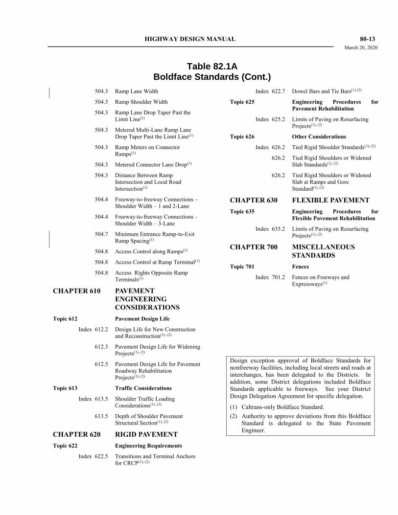
HIGHWAY DESIGN MANUAL 80-13 March 20, 2020
Table 82.1A
Boldface Standards (Cont.)
504.3 Ramp Lane Width
504.3 Ramp Shoulder Width
504.3 Ramp Lane Drop Taper Past the
Limit Line(1)
504.3 Metered Multi-Lane Ramp Lane
Drop Taper Past the Limit Line(1)
504.3 Ramp Meters on Connector
Ramps(1)
504.3 Metered Connector Lane Drop(1)
504.3 Distance Between Ramp
Intersection and Local Road
Intersection(1)
504.4 Freeway-to-freeway Connections –
Shoulder Width – 1 and 2-Lane
504.4 Freeway-to-freeway Connections –
Shoulder Width – 3-Lane
504.7 Minimum Entrance Ramp-to-Exit
Ramp Spacing(1)
504.8 Access Control along Ramps(1)
504.8 Access Control at Ramp Terminal(1)
504.8 Access Rights Opposite Ramp
Terminals(1)
CHAPTER 610 PAVEMENT
ENGINEERING
CONSIDERATIONS
Topic 612 Pavement Design Life
Index 612.2 Design Life for New Construction
and Reconstruction(1), (2)
612.3 Pavement Design Life for Widening
Projects(1), (2)
612.5 Pavement Design Life for Pavement
Roadway Rehabilitation
Projects(1), (2)
Topic 613 Traffic Considerations
Index 613.5 Shoulder Traffic Loading
Considerations(1), (2)
613.5 Depth of Shoulder Pavement
Structural Section(1), (2)
CHAPTER 620 RIGID PAVEMENT
Topic 622 Engineering Requirements
Index 622.5 Transitions and Terminal Anchors
for CRCP(1), (2)
Index 622.7 Dowel Bars and Tie Bars(1) (2)
Topic 625 Engineering Procedures for
Pavement Rehabilitation
Index 625.2 Limits of Paving on Resurfacing
Projects(1), (2)
Topic 626 Other Considerations
Index 626.2 Tied Rigid Shoulder Standards(1), (2)
626.2 Tied Rigid Shoulders or Widened
Slab Standards(1), (2)
626.2 Tied Rigid Shoulders or Widened
Slab at Ramps and Gore
Standard(1), (2)
CHAPTER 630 FLEXIBLE PAVEMENT
Topic 635 Engineering Procedures for
Flexible Pavement Rehabilitation
Index 635.2 Limits of Paving on Resurfacing
Projects(1), (2)
CHAPTER 700 MISCELLANEOUS
STANDARDS
Topic 701 Fences
Index 701.2 Fences on Freeways and
Expressways(1)
Design exception approval of Boldface Standards for
nonfreeway facilities, including local streets and roads at
interchanges, has been delegated to the Districts. In
addition, some District delegations included Boldface
Standards applicable to freeways. See your District
Design Delegation Agreement for specific delegation.
(1) Caltrans-only Boldface Standard.
(2) Authority to approve deviations from this Boldface
Standard is delegated to the State Pavement
Engineer.
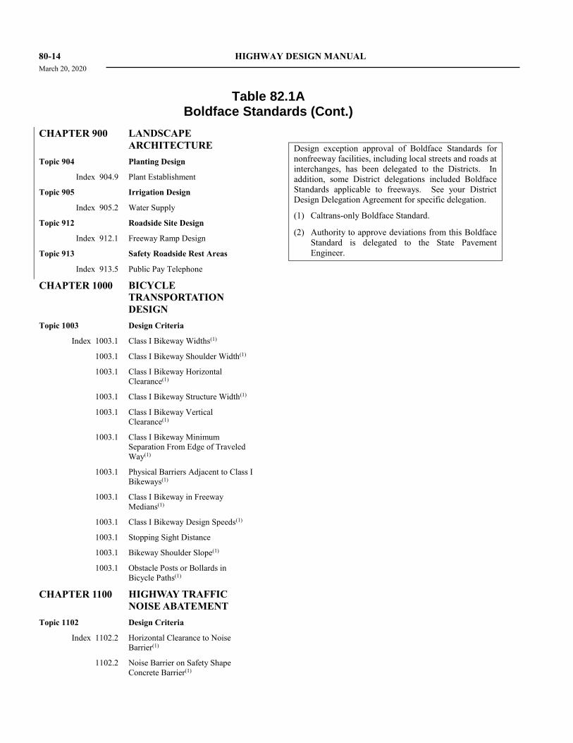
80-14 HIGHWAY DESIGN MANUAL
March 20, 2020
Table 82.1A
Boldface Standards (Cont.)
CHAPTER 900 LANDSCAPE
ARCHITECTURE
Topic 904 Planting Design
Index 904.9 Plant Establishment
Topic 905 Irrigation Design
Index 905.2 Water Supply
Topic 912 Roadside Site Design
Index 912.1 Freeway Ramp Design
Topic 913 Safety Roadside Rest Areas
Index 913.5 Public Pay Telephone
CHAPTER 1000 BICYCLE
TRANSPORTATION
DESIGN
Topic 1003 Design Criteria
Index 1003.1 Class I Bikeway Widths(1)
1003.1 Class I Bikeway Shoulder Width(1)
1003.1 Class I Bikeway Horizontal
Clearance(1)
1003.1 Class I Bikeway Structure Width(1)
1003.1 Class I Bikeway Vertical
Clearance(1)
1003.1 Class I Bikeway Minimum
Separation From Edge of Traveled
Way(1)
1003.1 Physical Barriers Adjacent to Class I
Bikeways(1)
1003.1 Class I Bikeway in Freeway
Medians(1)
1003.1 Class I Bikeway Design Speeds(1)
1003.1 Stopping Sight Distance
1003.1 Bikeway Shoulder Slope(1)
1003.1 Obstacle Posts or Bollards in
Bicycle Paths(1)
CHAPTER 1100 HIGHWAY TRAFFIC
NOISE ABATEMENT
Topic 1102 Design Criteria
Index 1102.2 Horizontal Clearance to Noise
Barrier(1)
1102.2 Noise Barrier on Safety Shape
Concrete Barrier(1)
Design exception approval of Boldface Standards for
nonfreeway facilities, including local streets and roads at
interchanges, has been delegated to the Districts. In
addition, some District delegations included Boldface
Standards applicable to freeways. See your District
Design Delegation Agreement for specific delegation.
(1) Caltrans-only Boldface Standard.
(2) Authority to approve deviations from this Boldface
Standard is delegated to the State Pavement
Engineer.
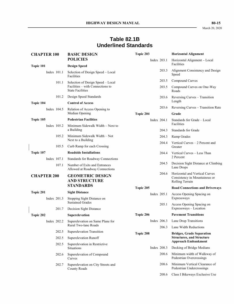
HIGHWAY DESIGN MANUAL 80-15 March 20, 2020
Table 82.1B
Underlined Standards
CHAPTER 100 BASIC DESIGN
POLICIES
Topic 101 Design Speed
Index 101.1 Selection of Design Speed – Local
Facilities
101.1 Selection of Design Speed – Local
Facilities – with Connections to
State Facilities
101.2 Design Speed Standards
Topic 104 Control of Access
Index 104.5 Relation of Access Opening to
Median Opening
Topic 105 Pedestrian Facilities
Index 105.2 Minimum Sidewalk Width – Next to
a Building
105.2 Minimum Sidewalk Width – Not
Next to a Building
105.5 Curb Ramp for each Crossing
Topic 107 Roadside Installations
Index 107.1 Standards for Roadway Connections
107.1 Number of Exits and Entrances
Allowed at Roadway Connections
CHAPTER 200 GEOMETRIC DESIGN
AND STRUCTURE
STANDARDS
Topic 201 Sight Distance
Index 201.3 Stopping Sight Distance on
Sustained Grades
201.7 Decision Sight Distance
Topic 202 Superelevation
Index 202.2 Superelevation on Same Plane for
Rural Two-lane Roads
202.5 Superelevation Transition
202.5 Superelevation Runoff
202.5 Superelevation in Restrictive
Situations
202.6 Superelevation of Compound
Curves
202.7 Superelevation on City Streets and
County Roads
Topic 203 Horizontal Alignment
Index 203.1 Horizontal Alignment – Local
Facilities
203.3 Alignment Consistency and Design
Speed
203.5 Compound Curves
203.5 Compound Curves on One-Way
Roads
203.6 Reversing Curves – Transition
Length
203.6 Reversing Curves – Transition Rate
Topic 204 Grade
Index 204.1 Standards for Grade – Local
Facilities
204.3 Standards for Grade
204.3 Ramp Grades
204.4 Vertical Curves – 2 Percent and
Greater
204.4 Vertical Curves – Less Than
2 Percent
204.5 Decision Sight Distance at Climbing
Lane Drops
204.6 Horizontal and Vertical Curves
Consistency in Mountainous or
Rolling Terrain
Topic 205 Road Connections and Driveways
Index 205.1 Access Opening Spacing on
Expressways
205.1 Access Opening Spacing on
Expressways – Location
Topic 206 Pavement Transitions
Index 206.3 Lane Drop Transitions
206.3 Lane Width Reductions
Topic 208 Bridges, Grade Separation
Structures, and Structure
Approach Embankment
Index 208.3 Decking of Bridge Medians
208.6 Minimum width of Walkway of
Pedestrian Overcrossings
208.6 Minimum Vertical Clearance of
Pedestrian Undercrossings
208.6 Class I Bikeways Exclusive Use
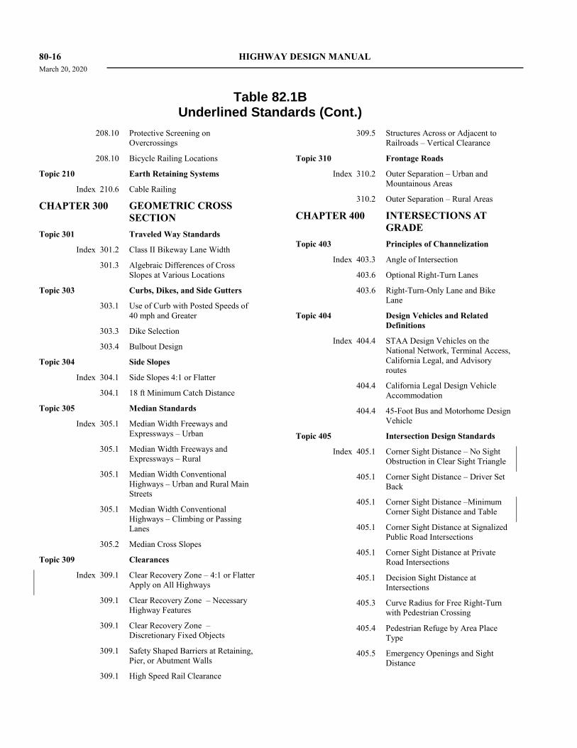
80-16 HIGHWAY DESIGN MANUAL
March 20, 2020
Table 82.1B
Underlined Standards (Cont.)
208.10 Protective Screening on
Overcrossings
208.10 Bicycle Railing Locations
Topic 210 Earth Retaining Systems
Index 210.6 Cable Railing
CHAPTER 300 GEOMETRIC CROSS
SECTION
Topic 301 Traveled Way Standards
Index 301.2 Class II Bikeway Lane Width
301.3 Algebraic Differences of Cross
Slopes at Various Locations
Topic 303 Curbs, Dikes, and Side Gutters
303.1 Use of Curb with Posted Speeds of
40 mph and Greater
303.3 Dike Selection
303.4 Bulbout Design
Topic 304 Side Slopes
Index 304.1 Side Slopes 4:1 or Flatter
304.1 18 ft Minimum Catch Distance
Topic 305 Median Standards
Index 305.1 Median Width Freeways and
Expressways – Urban
305.1 Median Width Freeways and
Expressways – Rural
305.1 Median Width Conventional
Highways – Urban and Rural Main
Streets
305.1 Median Width Conventional
Highways – Climbing or Passing
Lanes
305.2 Median Cross Slopes
Topic 309 Clearances
Index 309.1 Clear Recovery Zone – 4:1 or Flatter
Apply on All Highways
309.1 Clear Recovery Zone – Necessary
Highway Features
309.1 Clear Recovery Zone –
Discretionary Fixed Objects
309.1 Safety Shaped Barriers at Retaining,
Pier, or Abutment Walls
309.1 High Speed Rail Clearance
309.5 Structures Across or Adjacent to
Railroads – Vertical Clearance
Topic 310 Frontage Roads
Index 310.2 Outer Separation – Urban and
Mountainous Areas
310.2 Outer Separation – Rural Areas
CHAPTER 400 INTERSECTIONS AT
GRADE
Topic 403 Principles of Channelization
Index 403.3 Angle of Intersection
403.6 Optional Right-Turn Lanes
403.6 Right-Turn-Only Lane and Bike
Lane
Topic 404 Design Vehicles and Related
Definitions
Index 404.4 STAA Design Vehicles on the
National Network, Terminal Access,
California Legal, and Advisory
routes
404.4 California Legal Design Vehicle
Accommodation
404.4 45-Foot Bus and Motorhome Design
Vehicle
Topic 405 Intersection Design Standards
Index 405.1 Corner Sight Distance – No Sight
Obstruction in Clear Sight Triangle
405.1 Corner Sight Distance – Driver Set
Back
405.1 Corner Sight Distance –Minimum
Corner Sight Distance and Table
405.1 Corner Sight Distance at Signalized
Public Road Intersections
405.1 Corner Sight Distance at Private
Road Intersections
405.1 Decision Sight Distance at
Intersections
405.3 Curve Radius for Free Right-Turn
with Pedestrian Crossing
405.4 Pedestrian Refuge by Area Place
Type
405.5 Emergency Openings and Sight
Distance
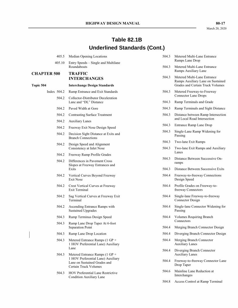
HIGHWAY DESIGN MANUAL 80-17 March 20, 2020
Table 82.1B
Underlined Standards (Cont.)
405.5 Median Opening Locations
405.10 Entry Speeds – Single and Multilane
Roundabouts
CHAPTER 500 TRAFFIC
INTERCHANGES
Topic 504 Interchange Design Standards
Index 504.2 Ramp Entrance and Exit Standards
504.2 Collector-Distributor Deceleration
Lane and “DL” Distance
504.2 Paved Width at Gore
504.2 Contrasting Surface Treatment
504.2 Auxiliary Lanes
504.2 Freeway Exit Nose Design Speed
504.2 Decision Sight Distance at Exits and
Branch Connections
504.2 Design Speed and Alignment
Consistency at Inlet Nose
504.2 Freeway Ramp Profile Grades
504.2 Differences in Pavement Cross
Slopes at Freeway Entrances and
Exits
504.2 Vertical Curves Beyond Freeway
Exit Nose
504.2 Crest Vertical Curves at Freeway
Exit Terminal
504.2 Sag Vertical Curves at Freeway Exit
Terminal
504.2 Ascending Entrance Ramps with
Sustained Upgrades
504.3 Ramp Terminus Design Speed
504.3 Ramp Lane Drop Taper At 6-foot
Separation Point
504.3 Ramp Lane Drop Location
504.3 Metered Entrance Ramps (1 GP +
1 HOV Preferential Lane) Auxiliary
Lane
504.3 Metered Entrance Ramps (1 GP +
1 HOV Preferential Lane) Auxiliary
Lane on Sustained Grades and
Certain Truck Volumes
504.3 HOV Preferential Lane Restrictive
Condition Auxiliary Lane
504.3 Metered Multi-Lane Entrance
Ramps Lane Drop
504.3 Metered Multi-Lane Entrance
Ramps Auxiliary Lane
504.3 Metered Multi-Lane Entrance
Ramps Auxiliary Lane on Sustained
Grades and Certain Truck Volumes
504.3 Metered Freeway-to-Freeway
Connector Lane Drops
504.3 Ramp Terminals and Grade
504.3 Ramp Terminals and Sight Distance
504.3 Distance between Ramp Intersection
and Local Road Intersection
504.3 Entrance Ramp Lane Drop
504.3 Single-Lane Ramp Widening for
Passing
504.3 Two-lane Exit Ramps
504.3 Two-lane Exit Ramps and Auxiliary
Lanes
504.3 Distance Between Successive On-
ramps
504.3 Distance Between Successive Exits
504.4 Freeway-to-freeway Connections
Design Speed
504.4 Profile Grades on Freeway-to-
freeway Connectors
504.4 Single-lane Freeway-to-freeway
Connector Design
504.4 Single-lane Connector Widening for
Passing
504.4 Volumes Requiring Branch
Connectors
504.4 Merging Branch Connector Design
504.4 Diverging Branch Connector Design
504.4 Merging Branch Connector
Auxiliary Lanes
504.4 Diverging Branch Connector
Auxiliary Lanes
504.4 Freeway-to-freeway Connector Lane
Drop Taper
504.6 Mainline Lane Reduction at
Interchanges
504.8 Access Control at Ramp Terminal
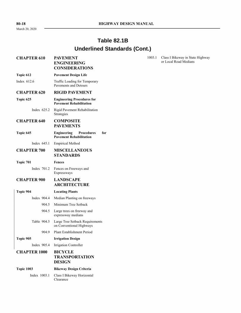
80-18 HIGHWAY DESIGN MANUAL
March 20, 2020
Table 82.1B
Underlined Standards (Cont.)
CHAPTER 610 PAVEMENT
ENGINEERING
CONSIDERATIONS
Topic 612 Pavement Design Life
Index 612.6 Traffic Loading for Temporary
Pavements and Detours
CHAPTER 620 RIGID PAVEMENT
Topic 625 Engineering Procedures for
Pavement Rehabilitation
Index 625.2 Rigid Pavement Rehabilitation
Strategies
CHAPTER 640 COMPOSITE
PAVEMENTS
Topic 645 Engineering Procedures for
Pavement Rehabilitation
Index 645.1 Empirical Method
CHAPTER 700 MISCELLANEOUS
STANDARDS
Topic 701 Fences
Index 701.2 Fences on Freeways and
Expressways
CHAPTER 900 LANDSCAPE
ARCHITECTURE
Topic 904 Locating Plants
Index 904.4 Median Planting on freeways
904.5 Minimum Tree Setback
904.5 Large trees on freeway and
expressway medians
Table 904.5 Large Tree Setback Requirements
on Conventional Highways
904.9 Plant Establishment Period
Topic 905 Irrigation Design
Index 905.4 Irrigation Controller
CHAPTER 1000 BICYCLE
TRANSPORTATION
DESIGN
Topic 1003 Bikeway Design Criteria
Index 1003.1 Class I Bikeway Horizontal
Clearance
1003.1 Class I Bikeway in State Highway
or Local Road Medians
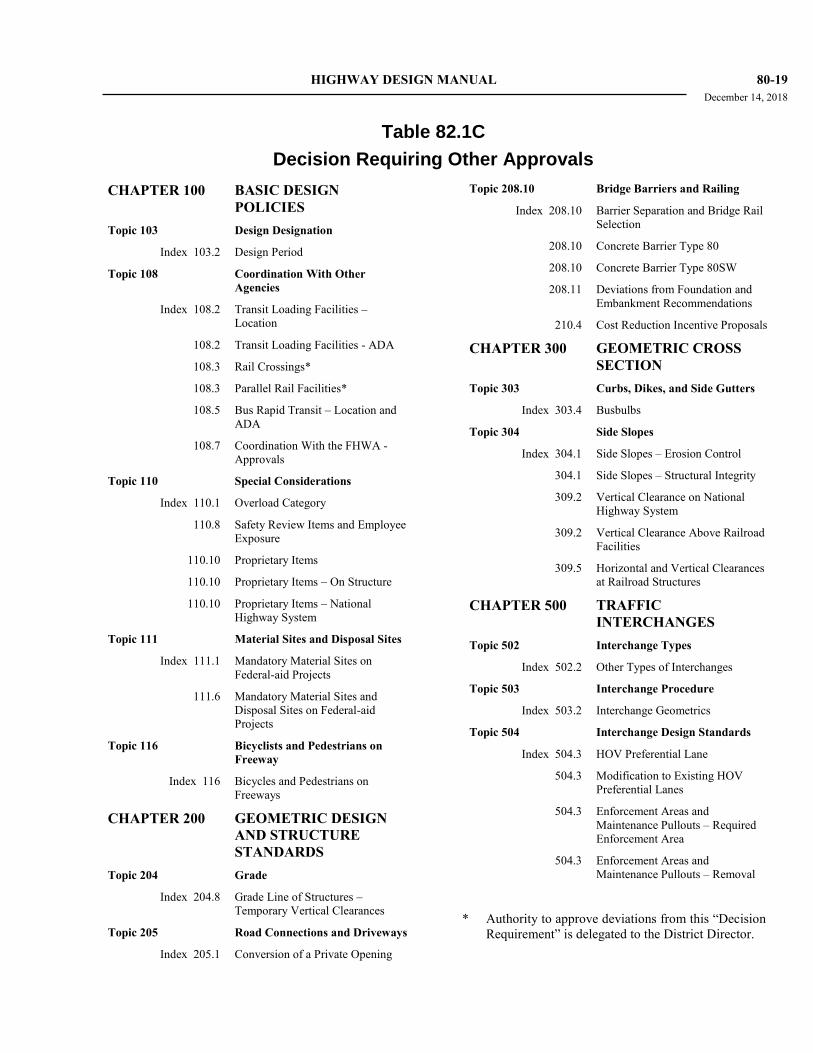
HIGHWAY DESIGN MANUAL 80-19 December 14, 2018
Table 82.1C
Decision Requiring Other Approvals
CHAPTER 100 BASIC DESIGN
POLICIES
Topic 103 Design Designation
Index 103.2 Design Period
Topic 108 Coordination With Other
Agencies
Index 108.2 Transit Loading Facilities –
Location
108.2 Transit Loading Facilities - ADA
108.3 Rail Crossings*
108.3 Parallel Rail Facilities*
108.5 Bus Rapid Transit – Location and
ADA
108.7 Coordination With the FHWA -
Approvals
Topic 110 Special Considerations
Index 110.1 Overload Category
110.8 Safety Review Items and Employee
Exposure
110.10 Proprietary Items
110.10 Proprietary Items – On Structure
110.10 Proprietary Items – National
Highway System
Topic 111 Material Sites and Disposal Sites
Index 111.1 Mandatory Material Sites on
Federal-aid Projects
111.6 Mandatory Material Sites and
Disposal Sites on Federal-aid
Projects
Topic 116 Bicyclists and Pedestrians on
Freeway
Index 116 Bicycles and Pedestrians on
Freeways
CHAPTER 200 GEOMETRIC DESIGN
AND STRUCTURE
STANDARDS
Topic 204 Grade
Index 204.8 Grade Line of Structures –
Temporary Vertical Clearances
Topic 205 Road Connections and Driveways
Index 205.1 Conversion of a Private Opening
Topic 208.10 Bridge Barriers and Railing
Index 208.10 Barrier Separation and Bridge Rail
Selection
208.10 Concrete Barrier Type 80
208.10 Concrete Barrier Type 80SW
208.11 Deviations from Foundation and
Embankment Recommendations
210.4 Cost Reduction Incentive Proposals
CHAPTER 300 GEOMETRIC CROSS
SECTION
Topic 303 Curbs, Dikes, and Side Gutters
Index 303.4 Busbulbs
Topic 304 Side Slopes
Index 304.1 Side Slopes – Erosion Control
304.1 Side Slopes – Structural Integrity
309.2 Vertical Clearance on National
Highway System
309.2 Vertical Clearance Above Railroad
Facilities
309.5 Horizontal and Vertical Clearances
at Railroad Structures
CHAPTER 500 TRAFFIC
INTERCHANGES
Topic 502 Interchange Types
Index 502.2 Other Types of Interchanges
Topic 503 Interchange Procedure
Index 503.2 Interchange Geometrics
Topic 504 Interchange Design Standards
Index 504.3 HOV Preferential Lane
504.3 Modification to Existing HOV
Preferential Lanes
504.3 Enforcement Areas and
Maintenance Pullouts – Required
Enforcement Area
504.3 Enforcement Areas and
Maintenance Pullouts – Removal
* Authority to approve deviations from this “Decision
Requirement” is delegated to the District Director.
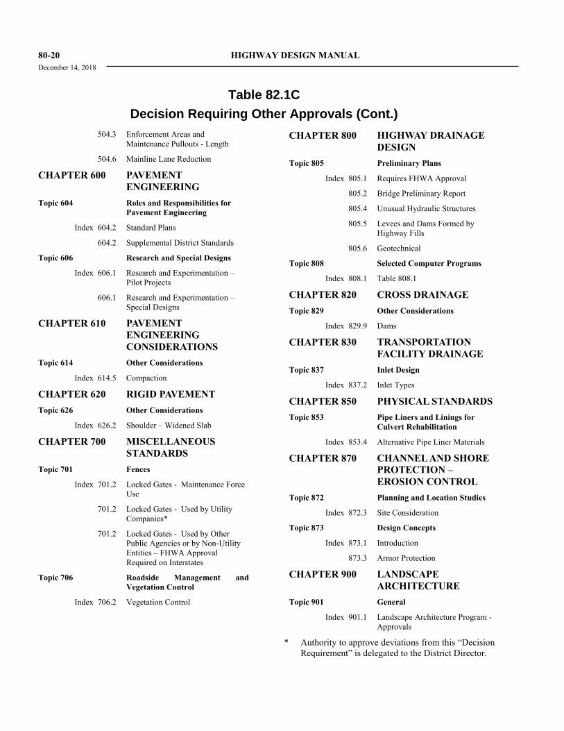
80-20 HIGHWAY DESIGN MANUAL
December 14, 2018
Table 82.1C
Decision Requiring Other Approvals (Cont.)
504.3 Enforcement Areas and
Maintenance Pullouts - Length
504.6 Mainline Lane Reduction
CHAPTER 600 PAVEMENT
ENGINEERING
Topic 604 Roles and Responsibilities for
Pavement Engineering
Index 604.2 Standard Plans
604.2 Supplemental District Standards
Topic 606 Research and Special Designs
Index 606.1 Research and Experimentation –
Pilot Projects
606.1 Research and Experimentation –
Special Designs
CHAPTER 610 PAVEMENT
ENGINEERING
CONSIDERATIONS
Topic 614 Other Considerations
Index 614.5 Compaction
CHAPTER 620 RIGID PAVEMENT
Topic 626 Other Considerations
Index 626.2 Shoulder – Widened Slab
CHAPTER 700 MISCELLANEOUS
STANDARDS
Topic 701 Fences
Index 701.2 Locked Gates - Maintenance Force
Use
701.2 Locked Gates - Used by Utility
Companies*
701.2 Locked Gates - Used by Other
Public Agencies or by Non-Utility
Entities – FHWA Approval
Required on Interstates
Topic 706 Roadside Management and
Vegetation Control
Index 706.2 Vegetation Control
CHAPTER 800 HIGHWAY DRAINAGE
DESIGN
Topic 805 Preliminary Plans
Index 805.1 Requires FHWA Approval
805.2 Bridge Preliminary Report
805.4 Unusual Hydraulic Structures
805.5 Levees and Dams Formed by
Highway Fills
805.6 Geotechnical
Topic 808 Selected Computer Programs
Index 808.1 Table 808.1
CHAPTER 820 CROSS DRAINAGE
Topic 829 Other Considerations
Index 829.9 Dams
CHAPTER 830 TRANSPORTATION
FACILITY DRAINAGE
Topic 837 Inlet Design
Index 837.2 Inlet Types
CHAPTER 850 PHYSICAL STANDARDS
Topic 853 Pipe Liners and Linings for
Culvert Rehabilitation
Index 853.4 Alternative Pipe Liner Materials
CHAPTER 870 CHANNEL AND SHORE
PROTECTION –
EROSION CONTROL
Topic 872 Planning and Location Studies
Index 872.3 Site Consideration
Topic 873 Design Concepts
Index 873.1 Introduction
873.3 Armor Protection
CHAPTER 900 LANDSCAPE
ARCHITECTURE
Topic 901 General
Index 901.1 Landscape Architecture Program -
Approvals
* Authority to approve deviations from this “Decision
Requirement” is delegated to the District Director.
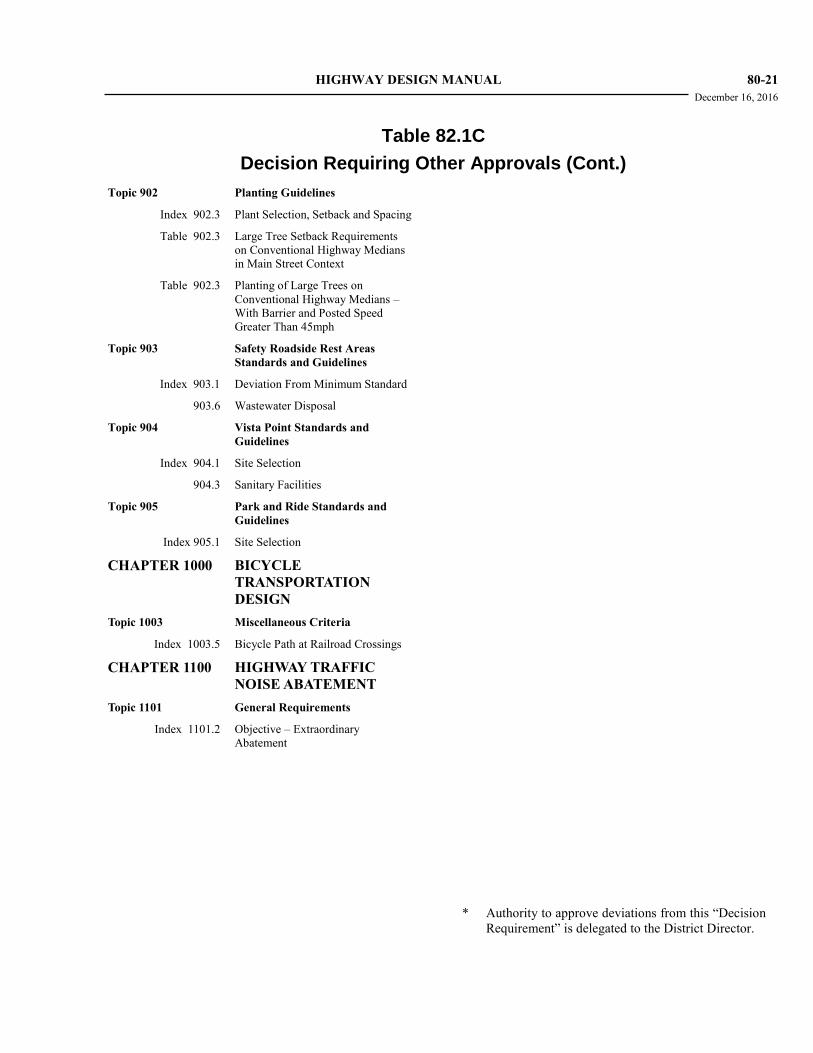
HIGHWAY DESIGN MANUAL 80-21 December 16, 2016
Table 82.1C
Decision Requiring Other Approvals (Cont.)
Topic 902 Planting Guidelines
Index 902.3 Plant Selection, Setback and Spacing
Table 902.3 Large Tree Setback Requirements
on Conventional Highway Medians
in Main Street Context
Table 902.3 Planting of Large Trees on
Conventional Highway Medians –
With Barrier and Posted Speed
Greater Than 45mph
Topic 903 Safety Roadside Rest Areas
Standards and Guidelines
Index 903.1 Deviation From Minimum Standard
903.6 Wastewater Disposal
Topic 904 Vista Point Standards and
Guidelines
Index 904.1 Site Selection
904.3 Sanitary Facilities
Topic 905 Park and Ride Standards and
Guidelines
Index 905.1 Site Selection
CHAPTER 1000 BICYCLE
TRANSPORTATION
DESIGN
Topic 1003 Miscellaneous Criteria
Index 1003.5 Bicycle Path at Railroad Crossings
CHAPTER 1100 HIGHWAY TRAFFIC
NOISE ABATEMENT
Topic 1101 General Requirements
Index 1101.2 Objective – Extraordinary
Abatement
* Authority to approve deviations from this “Decision
Requirement” is delegated to the District Director.