Embed Size (px)
Citation preview

Sioux Falls Regional Airport Master Plan May 2015 DRAFT Chapter 7 – Land Use Compatibility Page 7-1
CHAPTER 7: LAND USE COMPATIBILITY
Introduction
Land Use Compatibility Planning
Airports are community assets providing significant benefits. They facilitate the movement of people,
goods and services, promote tourism and trade, stimulate business development and support a variety
of jobs.
The objective of land use planning is to guide on-airport and off-airport land use development to be
compatible with airport operations. On-airport compatible land use is controlled by the airport and
primarily serves aeronautical activities. Off-airport land uses is not directly controlled by the airport.
Surrounding land uses compatible with airports are typically include those uses that can co-exist with a
nearby airport without either constraining the safe and efficient operation of the airport or exposing
people working or living nearby to unacceptable levels of noise or safety hazards. Compatible land use
also considers minimizing potential hazards to aircraft and the flying public. The impact of airport
planning decisions extends well beyond the airport property line thus must be considered.
Land use planning around airports is important to airports and communities for several reasons:
Safety - Compatibility is needed to maintain safety of the general and flying public. Risk should
be reduced to an acceptable level. The airport must also maintain operational utility within
identified safety and risk criteria.
Airport Utility - Land uses around airport should provide the airport so that there are not
undue restrictions placed on the airport’s existing or planned future arrival and departure
procedures. Opportunities for future development identified in the Airport Master Plan and
shown on the Federally (FAA) approved Airport Layout Plan should be considered.
Human Environment - Balancing the human environment with airport operations is important
to maintain an acceptable level of airport impacts (i.e. noise and visual exposure) with the
surrounding community.
Economic Development – Operational restrictions placed on the airport as a result of land use
compatibilities have the potential to have a trickle-down effect on the community. This
reduces the community’s ability to accommodate the aviation needs of the public and local
businesses, thus limiting economic development opportunities.
Incompatible land uses are one of the largest issues facing airports today, often resulting in conflicts
between airports and their communities. They also may result in airport operational and grant project
funding implications in certain situations. Building consistency between the recommendations in this
Airport Master Plan with airport land use compatibility standards and area-wide planning is vital for
maintaining compatible land use.
The objective of this chapter is to assist the Sioux Falls Regional Airport in identifying land use
standards and developing recommendations so that the airport can continue to meet safety criteria so
that airport operations and surrounding land uses can safety co-exist into the future. This chapter
should become framework to future land use planning efforts between Airport, City of Sioux Falls,
Minnehaha and Lincoln Counties.
Sioux Falls Regional Airport Master Plan May 2015 DRAFT Chapter 7 – Land Use Compatibility Page 7-2
Roles and Responsibilities
AIRPORT SPONSOR
As the airport sponsor, Sioux Falls Regional Airport Authority, applies and receives federal grants.
These federal grants require the Airport Authority to develop and maintain the airport compatible with
FAA rules and regulations through FAA Grant Assurances (obligations). There are currently 39 grant
assurances which an airport sponsor assumes as a contractual obligation with the Federal Government
when the sponsor accepts federal funds for airport development. These grant assurances describe how
the sponsor must operate the airport and serve the needs of the flying public. Grant assurances 20 and
21 pertain to compatible land use around airports.
FAA grant assurances require airports take appropriate action to protect airspace and restrict land uses
in the immediate vicinity to those compatible with airport operations. Compatible land use control is
the responsibility of the airport sponsor, the Sioux Falls Regional Airport Authority.
FEDERAL AVIATION ADMINISTRATION (FAA)
The FAA can provide guidance and funding to promote compatible land development around airports;
however, it has no regulatory authority for controlling land uses. State and local governments are
responsible for land use planning, zoning and regulations. Grant assurances are developed by the FAA
to protect federal investments in airports, but are the responsibility of the airport sponsor to maintain.
The FAA monitors all obligated airports to ensure they comply with the requirements of the grant
assurances through its Compliance Program. If the sponsor fails to take the necessary corrective action,
the FAA can legally impose penalties on the sponsor, including the loss of federal funding.
As defined by law, the FAA’s authority to enforce most regulations and grant assurances is limited to
within the airport boundaries. The FAA’s only authority on compatible land use planning is through the
grant assurances airport sponsors must adhere to in order to obtain federal funding for airport
improvements. In most cases, the most practical and cost effective method for a sponsor to affect
compatible land use outside of the airport’s property is through zoning or easements rather than
through land acquisition.
STATE OF SOUTH DAKOTA
South Dakota Codified Laws allow counties and cities of the state to enter into joint planning and
zoning agreements. Municipalities may also exercise zoning powers within three miles of their
corporate limits subject to county approval. There are no minimum land use development and airspace
standards around airports.
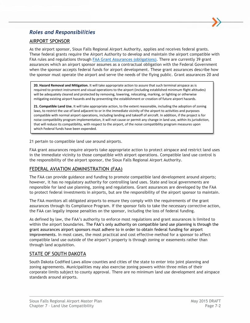
20. Hazard Removal and Mitigation. It will take appropriate action to assure that such terminal airspace as is required to protect instrument and visual operations to the airport (including established minimum flight altitudes) will be adequately cleared and protected by removing, lowering, relocating, marking, or lighting or otherwise mitigating existing airport hazards and by preventing the establishment or creation of future airport hazards.
21. Compatible Land Use. It will take appropriate action, to the extent reasonable, including the adoption of zoning laws, to restrict the use of land adjacent to or in the immediate vicinity of the airport to activities and purposes compatible with normal airport operations, including landing and takeoff of aircraft. In addition, if the project is for noise compatibility program implementation, it will not cause or permit any change in land use, within its jurisdiction, that will reduce its compatibility, with respect to the airport, of the noise compatibility program measures upon which Federal funds have been expended.

Sioux Falls Regional Airport Master Plan May 2015 DRAFT Chapter 7 – Land Use Compatibility Page 7-3
South Dakota Codified Laws, Title 50, Chapter 06A grants Regional Airport Authorities Zoning the power
to establish comprehensive airport zoning regulations and shall have the same powers as other political
subdivisions to adopt and enforce airport zoning regulations.
Additional State regulations and laws in place under Chapter 50-9 concern structures affecting aviation
in South Dakota. Under Chapter 50-9-1, South Dakota Aeronautics Commission approval is required for
any new or altered structure greater than 200 feet above the terrain, and for any new or altered
structure within a 100:1 slope from the runway at a public airport with a runway with a length 3,200
feet or greater.
SURROUNDING JURISDICTIONS
Local jurisdictions are responsible for developing and enforcing land use planning, zoning and
regulations. Development proposals are reviewed and approved at this local level through an
established process. Any adopted airport land use compatibility zoning that restricts the type and
height of new development, for example, is enforced by the local jurisdiction. For the Sioux Falls
Regional Airport, surrounding jurisdictions include the City of Sioux Falls, Minnehaha and Lincoln
Counties.
Land Use Compatibil ity Elements
Overview
Four elements should be considered in order to achieve land use compatibility:
Airspace
Safety
Noise
Airport Compliance
A general description of each element is provided based primarily on criteria developed by the FAA.
Airspace
The airspace compatibility element includes avoiding vertical development that
reduces the level of safety, increases risks of aircraft accidents or measurably reduces
the operational utility of airports. Types of development that may impair airports from
meeting this objective include man-made structures (e.g. buildings, radio towers and
wind turbines) and natural growth objects and terrain (e.g. trees, ground). Other
airspace impacts include visual or electronic interference. Examples include bright
lights near runways causing glare, or airborne emissions from industrial plants that
may reduce pilot visibility or cause severe turbulence. The risk of accidents involving
airspace obstructions can be lowered through the efforts of the FAA to evaluate and
manage airspace and through local government control over the creation of
incompatible structures.
The definition of airspace requirements is primarily accomplished through standards
established in Title 14 of the Code of Federal Regulations (CFR). More specifically, 14
CFR Part 77, Objects Affecting Navigable Airspace. The standards established in Part
77 relate to the size of the largest aircraft using the runway, the approach type, and
the minimum visibility under which the runway can still be used by aircraft. Part 77
standards appear in the form of three dimensional “imaginary surfaces” as illustrated
in Figure 7-1.

Sioux Falls Regional Airport Master Plan May 2015 DRAFT Chapter 7 – Land Use Compatibility Page 7-4
FAA Order 8260.3B Terminal Instrument Procedures (TERPS) identify airspace standards for instrument
approaches and departures. These standards are defined by FAA. Obstructions to TERPS surfaces may
result in reduced utility for instrument operations to an airport. These surfaces are reviewed by FAA on
a case-by-case basis to ensure compatibility and safety. Other airspace surfaces and review procedures
apply from FAA Order 7400.2 Procedures for Handling Airspace Matters including traffic pattern
airspace to protect for safe aircraft maneuvering around the airport.
Figure 7-1 – Part 77 Imaginary Surfaces
Source: National Geodetic Survey (NGS)
Airspace standards affect land uses within and around the airport. A project proponent is required to
file FAA Form 7460-1 Notice of Proposed Construction prior to proposing new development on-airport
or within the vicinity of the airport as defined in Part 77. Three typical responses include:
No Objection/No Hazard: The proposed construction/alteration did not exceed obstruction
standards and lowering, lighting or marking is not required.
Conditional Determination/Notice of Presumed Hazard: The proposed construction/alteration
would be acceptable contingent upon implementing mitigating measures (i.e. lowering, lighting
or marking the object)
Objectionable/Hazard: The proposed construction/alteration is determined to be a hazard to
air navigation and is thus objectionable. The reasons for this determination are outlined to the
proponent.
If a Part 77 or TERPS airspace surface would be penetrated by a constructed object, the FAA then
performs an extended study to determine whether the object poses an operational problem for the
relevant airport. If the penetration does not pose an operational impact, it may be determined not to
be a hazard.

Sioux Falls Regional Airport Master Plan May 2015 DRAFT Chapter 7 – Land Use Compatibility Page 7-5
Operational impacts are those that affect aircraft operations. Examples of measurable operational
impacts include reducing available runway length, increasing the minimum flight altitude in a specific
area, increasing the minimum climb gradient for airport departure, diverting air traffic away from an
obstacle, or increasing the minimum descent altitude/flight visibility at the obstacle location for
airport arrivals.
It is important to acknowledge that the FAA’s role is limited to evaluating the aeronautical effects of
proposed structures; the FAA has no legal authority to stop the construction of any proposed structure.
However, as previously mentioned, FAA grant assurance obligations require sponsors to take reasonable
action to prevent and remove hazards to air navigation. Typical examples include local land use zoning
for FAR Part 77 and TERPS airspace surfaces.
Safety
FAA design standards and regulations prescribe a number of zones and imaginary surfaces intended to
protect aircraft and their occupants while landing or taking off. However, the safety element primarily
associated with compatible land use is focused on minimizing risks to persons and property on the
ground.
Assessing the risks of aircraft accidents and creating policies to address those risks is challenging
because aircraft accidents are rare and the specific circumstances of an accident are nearly impossible
to predict. FAA has identified a 1 and 10 million safety threshold as an extremely remote likelihood of
occurrence1. National Transportation Safety Board (NTSB) data gathered between 1990 and 2000
indicated that approximately 95 percent of all aircraft accidents happen either on or near airports,
with most occurring during the approach or departure phases of flight.
In an effort to reduce the public safety risk associated with aircraft operations, communities typically
use FAA airport design standards and safety compatibility guidelines developed by state aeronautical
agencies to formulate safety policies. FAA has defined minimum land use standards in the form of a
Runway Protection Zone with additional safety requirements defined by State and local jurisdictions.
RUNWAY PROTECTION ZONES
FAA airport design standards, as contained in Advisory Circular (AC) 150/5300-13A Airport Design
define a number of zones, areas, and imaginary surfaces that are intended to protect aircraft and their
occupants during operations on and around an airport. One zone, the Runway Protection Zone (RPZ), is
intended to protect people and property on the ground for approach and departure areas beyond the
runway end. It also mitigates the risk of an aircraft collision with an object on the ground.
According to FAA, the function of the RPZ is as follows:
“The RPZ function is to enhance the protection of people and property on the ground. Where
practical, airport owners should own the property under the runway approach and departure
areas to at least the limits of the RPZ. It is desirable to clear the entire RPZ of all above-
ground objects. Where this is impractical, airport owners, as a minimum, should maintain the
RPZ clear of all facilities supporting incompatible activities.”
Formerly known as clear zones, the RPZ is a trapezoidal-shaped area, centered on the extended
runway centerline and normally begins 200 feet beyond the end of the runway or area useable for
landing or takeoff. The RPZ dimensions were developed through the analysis of aircraft accidents and
calculated to enclose the area on the ground with the highest probability of risk due to an aircraft
accident.
1 FAA System Safety Handbook (Federal Aviation Administration, 2000)

Sioux Falls Regional Airport Master Plan May 2015 DRAFT Chapter 7 – Land Use Compatibility Page 7-6
There are two components of RPZs that are evaluated and analyzed in the master planning process.
One component is the required dimensions of the RPZ, which are functions of the design aircraft, type
of operation and visibility minimums. There are separate approach and departure RPZs however the
approach RPZ is usually more stringent. The Central Portion of the RPZ is the area beyond the Runway
Object Free Area and is the area with the highest risk to persons or property on the ground. The second
component is the use of the land within the boundaries of the RPZ, which must meet FAA criteria and
regulations, and is commonly discussed as an element of compatible land use. FAA desires a clear RPZ
and airport control within its limits. Figure 7-2 identifies the shape of a typical approach and
departure RPZ.
Figure 7-2 – Runway Protection Zone
Source: FAA AC 150/5300-13A, Airport Design
RPZs and the effort to ensure compatible land use within them are currently a high priority for the
FAA. Protection of the RPZ is achieved through airport control over RPZs including fee title ownership
or clear zone easement. The increased emphasis has resulted in additional requirements to monitor
and analyze RPZs for conformance to established policies and standards. In September 2012, FAA
published Interim Guidance on Land Uses Within a Runway Protection Zone providing airports with
guidance on land use compatibility standards. In some cases, a separate RPZ Alternatives Analysis must
be prepared to meet these requirements. The standards are summarized below:
New or Modified Land Uses: FAA coordination is required for new or modified land uses within
the RPZ as a result of an airfield project, change in RPZ dimensions or local development
proposal.
Land Uses Requiring FAA Coordination: Building and structures, residential land uses,
transportation facilities (i.e. roads, parking, rail), fuel storage, hazardous material storage,
wastewater treatment, above-ground utility infrastructure

Sioux Falls Regional Airport Master Plan May 2015 DRAFT Chapter 7 – Land Use Compatibility Page 7-7
Alternatives Analysis: A full range of alternatives must be evaluated prior to FAA coordination
that avoid introducing the land use into the RPZ, minimize the impact of the land use in the
RPZ and mitigate risk to people and property on the ground.
Existing Land Uses in the RPZ: No change in policy, airports should work with FAA to remove
or mitigate the risk of any existing incompatible land uses in the RPZ. Incompatible land uses in
the RPZ from previous FAA guidance include but are not limited to residences, places of public
assembly (i.e. uses with high concentration of persons), fuel storage facilities and wildlife
attractants.
FAA has acknowledged the ongoing update to the land use compatibility advisory circular where an RPZ
land use consideration section will be added. As of the writing of this Master Plan, the document has
not yet been released by FAA in draft form.
OTHER SAFETY ZONES
Communities typically use FAA airport design standards and safety compatibility guidelines developed
by state aeronautical agencies to formulate safety policies. A good source for safety compatibility
guidelines is the California Airport Land Use Planning Handbook. The guidelines in this document have
been used as the foundation for the land use compatibility planning nationwide. Several state
aeronautical agencies have adapted it for use in developing their own airport land use planning
handbooks. The method used in these handbooks involves the creation of as many as six safety
compatibility zones that encompass airport owned property and lands surrounding the airport. Each
safety compatibility zone is assigned compatible development criteria involving acceptable and
prohibited land uses and acceptable maximum development densities. The development criteria for
each safety zone are directly related to noise levels and the risk of aircraft accidents within that zone.
These identified standards and guidance help airports, communities and jurisdictions prevent
incompatible land uses around airports.
Airports and States have recognized the need to protect land use around airports beyond the Runway
Protection Zones. Some states including California, Washington and Minnesota have developed land use
compatibility guidebooks adopted minimum airport zoning standards. Minnesota, for example, requires
a minimum level of land use and airspace zoning to receive aviation funding. No such minimum land
use standards exist in South Dakota, however Regional Airport Authorities have the authority to zone
similar to municipalities.
WILDLIFE HAZARDS
The wildlife element is focused on minimizing risks associated with wildlife in the
vicinity of an airport. Hazardous wildlife use natural or artificial habitats on or near
an airport for food, water or cover. Wildlife in the area of airport operations may result
in an aircraft-wildlife strike. FAA AC 150/5200-33, Hazardous Wildlife Attractants On or
Near Airports, recommends wildlife attractants be located at least 10,000 feet away from the Air
Operations Area (AOA) for airports primarily serving turbine-powered aircraft. The AOA is any area of
an airport used or intended to be used for landing, takeoff, or surface maneuvering of aircraft. For all
airports, the FAA recommends a distance of 5 statute miles between the furthest edges of the airport’s
AOA and the hazardous wildlife attractant if the attractant could cause hazardous wildlife movement
into or across the approach or departure airspace.
According to NTSB, 78 percent of bird strikes happen below 1,000 feet and 90 percent occur under
3,000 feet. A 5 statute mile distance from the AOA protects approach, departure and circling airspace.
Sioux Falls Regional Airport Master Plan May 2015 DRAFT Chapter 7 – Land Use Compatibility Page 7-8
Examples of potential wildlife hazards include storm water management facilities
(unless designed to minimize wildlife attractiveness), wetlands that attract wildlife,
artificial bodies of water, golf courses (unless they have a wildlife management
program) and confined livestock operations within 10,000 feet for turbine-powered
aircraft. Facilities not recommended within 5 miles of the AOA include new wastewater
treatment facilities and new landfills.
The FAA recommends that public-use airport sponsors implement the standards and practices contained
in AC 150/5200-33. The FAA also recommends the guidance in this Advisory Circular for land-use
planners, and developers of projects, facilities, and activities on or near airports.
Noise
The noise element is focused on minimizing the number
of people exposed to high frequency and event levels of
aircraft noise. Noise emitted from aircraft can affect the
well-being of persons living or working near an airport.
While there are several effects of aircraft noise upon
people, the most common is annoyance. Annoyance can
be defined as the overall adverse reaction of people to
noise. Other effects of aircraft noise include sleep
disturbance and speech interference. Noise affects each
individual differently.
Noise analysis for airports is typically conducted using
FAA’s Integrated Noise Model (INM) software. The noise
measurement recommended by FAA for use in the
analysis of aircraft noise is the Day-Night Average Sound
Level (DNL). The DNL is defined as the average annual
weighted sound level produced by aircraft at a location
during a 24-hour period. It is not a measure of an
individual noise event. An additional 10 decibel (dB)
weight is applied to aircraft noise occurring between 10
p.m. and 7 a.m., when aircraft noise is more likely to create an annoyance. Land use compatibility
guidelines for DNL average sound levels has been established by FAA for residential, public, commercial
manufacturing and recreational land uses. The FAA has accepted a maximum of 65 dB DNL as the
threshold of concern for noise impacts over residential areas without mitigation. The FAA has
determined that a significant noise impact would occur if a detailed noise analysis indicates an action
would result in an increase of 1.5 dBs or greater within the DNL 65 dB contour over a noise sensitive
area.
FAR Part 150 Airport Noise Compatibility Planning regulation identifies rules and guidelines and
authorizes Federal financial assistance for the preparation of airport noise compatibility programs. FAR
Part 150 is a voluntary program that airports may complete to seek compatible land uses. The Part 150
Study process identifies aircraft traffic mix, creates Noise Exposure Maps, identifies land use
incompatibilities around the airport as a result of noise exposure, and recommends measures to
mitigate existing and prevent future land use incompatibilities as part of a Noise Compatibility
Program. A Part 150 study completed by an airport is approved by FAA. According to FAA, 256 airports
received FAA funding nationwide through 2013 to complete a Part 150 study. Implementing noise
mitigation projects may then be eligible for FAA funding.
COMMON SOUNDS AND THEIR ASSOCIATED DECIBEL LEVELS
Sioux Falls Regional Airport Master Plan May 2015 DRAFT Chapter 7 – Land Use Compatibility Page 7-9
Airport Compliance
Airports that receive FAA funds are subject to FAA grant assurances (obligations). These assurances
typically last a period of 20 years since the last FAA grant was accepted by the airport sponsor. Land
identified for use as an airport is also subject to conditions. Currently, there are 39 grant assurances
identified by FAA. FAA has published Order 5190.6B Airport Compliance Manual to assist FAA personnel
and airport sponsors to maintain compliance with grand and land obligations. Airports that do not abide
by grant assurances are subject to withholding of FAA grant funding.
Common airport compliance issues relating to land use include non-aeronautical land uses, airport land
releases and “through-the-fence” operations.
NON-AERONAUTICAL USE OF AIRPORT PROPERTY
Airport property is to be used for aeronautical purposes. In order for an airport to develop land for non-
aeronautical use, the FAA must first approve of the change in airport property use from aeronautical to
non-aeronautical. All airport property is identified in the Exhibit “A”/Airport Property Map.
LAND RELEASES
When requested, the FAA will consider a release, modification, reform, or amendment of any airport
agreement to the extent that such action has the potential to protect, advance, or benefit the public
interest in civil aviation. Such action may involve only relief from specific limitations or covenants of
an agreement or it may involve a complete and total release that authorizes subsequent disposal of
federally obligated airport property. Common types of release requests include concurrent use, request
for change in use or the sale/disposal of airport property.
THROUGH-THE-FENCE OPERATIONS
Agreements that permit access to the airfield by aircraft based on land adjacent to, but not a part of,
the airport property are commonly referred to as a “through-the-fence'' operation (even though a
perimeter fence may not be visible). “Through-the-fence” arrangements can encumber the airport
property and reduce an airport’s ability to meet its federal obligations.
As a general principle, the FAA does not support airport requests to enter into any agreement that
grants “through-the-fence” access to the airfield for aeronautical businesses that would compete with
an on-airport aeronautical service provider such as a Fixed-Based Operator (FBO).
Commercial service airports are not permitted to enter into residential through-the-fence
arrangements. However, sponsors of general aviation airports may enter into such an arrangement if
the airport sponsor complies with the requirements of section 136. This must be a written agreement
that requires the property owner to pay access charges that are comparable to similar on-airport
tenants, bear the cost of maintaining infrastructure, maintain the property for non-commercial use and
prohibit additional access and prohibit aircraft refueling.
Land Use Compatibil ity Review
Surrounding Land Use Overview
Land uses surrounding the airport are primarily located within the City of Sioux Falls, but also fall into
areas of Minnehaha County within a joint extraterritorial zoning jurisdiction area.
Within Sioux Falls city limits, areas south of the airport consist of multiple land uses including
recreational, commercial, industrial and single family residential land uses. Elmwood Golf Course is
located immediately southwest of airport property. A portion of the golf course is currently within

Sioux Falls Regional Airport Master Plan May 2015 DRAFT Chapter 7 – Land Use Compatibility Page 7-10
airport property but is pending release back to the City of Sioux Falls. Portions east of the airport area
surrounded by industrial and office land uses. Areas north of the airport are generally undeveloped
with conservation/green space and agricultural/transition land uses within the Sioux Falls city limits.
The Big Sioux River and Diversion Channel provide 100-year floodplain protection with a drainage way
to the north, away from the airport.
Within the last five years, land immediately west of the airport has been developed into what is known
as the Sanford Sports Complex. This area includes a City park, Pentagon sports arena, indoor sports
facilities, restaurants and hotels. This are is generally classified as general institutional and
recreational/conservation land uses. Other areas west of the airport are identified as
agricultural/transition land uses with commercial land uses further northwest within Sioux Falls.
Land uses within Minnehaha County are located north of the airport. Land in these areas are now
generally used for rural residential and agricultural land uses. Other areas north of 60th Street West are
identified as conservation, light residential, light industrial and planned development.
Surrounding land uses/zoning as compared with existing and proposed airport development are
identified in Exhibit 7-1.
Land Use Plans
COMPREHENSIVE DEVELOPMENT PLANS
SHAPE Sioux Falls 2035 Comprehensive Plan
The City of Sioux Falls adopted their SHAPE Sioux Falls
2035 Comprehensive Plan in 2009. This comprehensive
land use plan provides for the orderly development of
the City of Sioux Falls.
Most of the land uses to the south and east of the
airport are not planned to change. Areas to the west
and north of the airport within the Runway 15
approach along and near 60th Street are identified as
Tier 1 development areas indicating they are priority
development areas for the City. These areas are
planned for light industrial land uses. Land uses
associated with a regional employment center are
planned around the Interstate 29 and 60th Street
interchange.
Minnehaha County Comprehensive Plan
Minnehaha County adopted their comprehensive land
use planning document in 1998. Land to the north of
the airport on the immediate edge of the City of Sioux
Falls is identified as transition area for potential urban expansion of City limits. Land to the north of
the airport along and east of the Big Sioux River are within the 100-year floodplain which limits
development.
2035 SHAPE SIOUX FALLS COMPREHENSIVE PLAN
GROWTH AREAS
Sioux Falls
Regional Airport
Conservation
(Floodplain)
Tier I Development Area
Regional
Employment
Center
City of Sioux Falls
Undeveloped Land

RU N WAY 9 / 2 7 - 3 , 1 5 1 ' x 7 5 '
RUNWAY 3/21 - 8
,999' x 150' RUNWAY 15/33 - 8 ,000 ' x 150'
!(2
!(1
!(3
!(4
!(4!(4
!(7
!(5
!(9
!(8
!(10
!(11
!(6
Big Sioux Rive
r
Diversion Channel
Future Road
Future Road Future Road
Dakota & Iowa Railroad
Dakota & Iowa RailroadBurlington Northern Santa Fe RR
W 60th St
N 4th Ave
N Minnesota Ave
W Russell St
N Westport Ave
262nd St
W Bailey St
N F Av
e
North
Dr
N Ditch Rd
W Blackhawk St
W Benson Rd
N 1st Ave
A Ave
N K Av
eN M Av
e
E 60th St
N Indu
strial A
ve
W Delaware St
D Ave
W Cherokee St
W Algonquin St
N Kiwanis Ave
N Main Ave
W 68th StW 66th St
W Brookings St
E Benson RdN C
Ave
W 54th St
E 56th St
B Ave
E 54th St
W Rice St
E 50th St
N John Orr Dr
N Jaycee Ln
North Dakota Ave
W Walnut St
E Maple St
N 2nd Ave
N West Ave
N Western Ave
E Hermosa Dr
N Prairie Ave
N E Av
e
E 40th St
N Phillips Ave
W Elkhorn St
N 3rd Ave
E 58th St
N H Av
e
W Hangar St
E Amidon St
N Bobhalla Dr
W Maple St
W Skyline Dr
W Mulberry St
N Elmwood Ave
W Weather Ln
N Sp
ring A
ve
W Kingston Dr
N Rive
rside A
veN Granite Ln
E Falls Park Dr
W Sencore Dr
N Martindale Rd
N Wa
lts Av
e
N Wi
lliams
Ave
W Bennett St
E Hinks Ln
N 6th Ave
W 51st St N
W Delrich Dr
N Jenifer Pl
E Rogers Cir
N Lake Ave
E Walnut St
N 4th Ave
W Russell Svc Rd
W Rice St
W Bailey StW Brookings St
N E Av
e
N No
rthvie
w Ave
§̈¦I-90
PRELIMINARY ´ Sioux Falls Regional AirportJoe Foss Field
Surrounding Land UseExhibit 7-1
*Intended for Planning Purposes OnlyJ:\air
port\1
4513
104\G
IS_MP
\_Map
s\7-1_
Surro
undin
gLan
dUse
.mxd
TLG
4/30/2
015
0 0.5 10.25Miles
LegendExisting Part 77 ApproachExisting Departure SurfaceExisting Runway Protection ZoneExisting Runway Object Free AreaFuture Part 77 ApproachFuture Runway Protection ZoneUltimate Part 77 ApproachUltimate Runway Protection ZoneCity LimitsExisting Airport PropertyFuture Airport PropertyFuture EasementUltimate Easement
ZoningAgriculture
Airport
Commercial
Industrial
Institutional
Recreation Conservation
Residential
1. Sanford Sports Complex2. Elmwood Golf Course3. Elmwood Park4. All City Elementary5. Veterans Memorial Park6. Ridgecrest Baptist Church7. Resurrection Apostolic Pentecostal8. Tower Park9. Falls Park10. Crossroads Community Church11. Cornerstone Prison Church
Source: City of Sioux Falls SHAPE Places Zoning Ordinance (2014), Joint Zoning Ordinance for Minnehaha County and the City of Sioux Falls (2002).
Minnehaha County(Mapleton Township)
City of Sioux Falls
Sioux Falls Regional Airport Master Plan May 2015 DRAFT Chapter 7 – Land Use Compatibility Page 7-12
COMMUNITY LAND USE PLANS
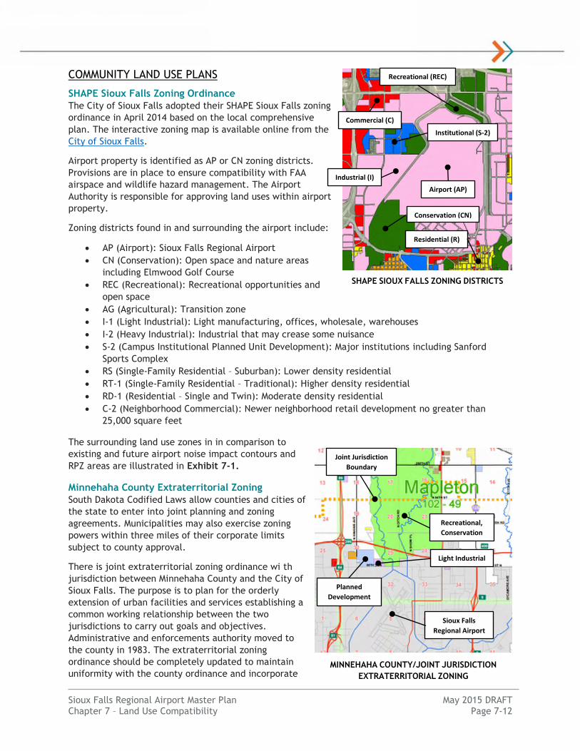
SHAPE Sioux Falls Zoning Ordinance
The City of Sioux Falls adopted their SHAPE Sioux Falls zoning
ordinance in April 2014 based on the local comprehensive
plan. The interactive zoning map is available online from the
City of Sioux Falls.
Airport property is identified as AP or CN zoning districts.
Provisions are in place to ensure compatibility with FAA
airspace and wildlife hazard management. The Airport
Authority is responsible for approving land uses within airport
property.
Zoning districts found in and surrounding the airport include:
AP (Airport): Sioux Falls Regional Airport
CN (Conservation): Open space and nature areas
including Elmwood Golf Course
REC (Recreational): Recreational opportunities and
open space
AG (Agricultural): Transition zone
I-1 (Light Industrial): Light manufacturing, offices, wholesale, warehouses
I-2 (Heavy Industrial): Industrial that may crease some nuisance
S-2 (Campus Institutional Planned Unit Development): Major institutions including Sanford
Sports Complex
RS (Single-Family Residential – Suburban): Lower density residential
RT-1 (Single-Family Residential – Traditional): Higher density residential
RD-1 (Residential – Single and Twin): Moderate density residential
C-2 (Neighborhood Commercial): Newer neighborhood retail development no greater than
25,000 square feet
The surrounding land use zones in in comparison to
existing and future airport noise impact contours and
RPZ areas are illustrated in Exhibit 7-1.
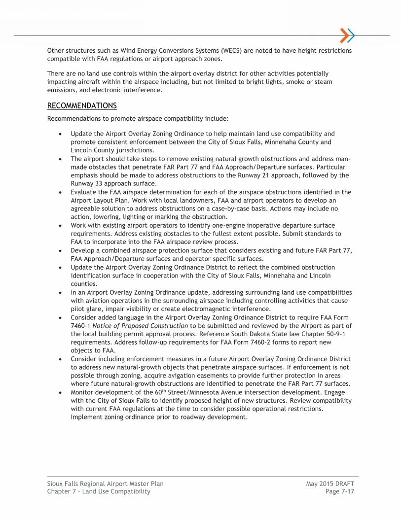
Minnehaha County Extraterritorial Zoning
South Dakota Codified Laws allow counties and cities of
the state to enter into joint planning and zoning
agreements. Municipalities may also exercise zoning
powers within three miles of their corporate limits
subject to county approval.
There is joint extraterritorial zoning ordinance wi th
jurisdiction between Minnehaha County and the City of
Sioux Falls. The purpose is to plan for the orderly
extension of urban facilities and services establishing a
common working relationship between the two
jurisdictions to carry out goals and objectives.
Administrative and enforcements authority moved to
the county in 1983. The extraterritorial zoning
ordinance should be completely updated to maintain
uniformity with the county ordinance and incorporate
Sioux Falls
Regional Airport
MINNEHAHA COUNTY/JOINT JURISDICTION
EXTRATERRITORIAL ZONING
SHAPE SIOUX FALLS ZONING DISTRICTS
Airport (AP)
Conservation (CN)
(REC)
Institutional (S-2)
Recreational (REC)
Residential (R)
(REC)
Commercial (C)
Industrial (I)
Sioux Falls
Regional Airport
Joint Jurisdiction
Boundary
Recreational,
Conservation
Light Industrial
Planned
Development

Sioux Falls Regional Airport Master Plan May 2015 DRAFT Chapter 7 – Land Use Compatibility Page 7-13
changes based on the adopted Sioux Falls 2015 Growth Management Plan. The current ordinance is
from 2002. Joint jurisdiction between Sioux Falls and Minnehaha County exists within approximately
two miles north of the airport.
Areas to the northwest of the airport within or near the Runway 15 approach are zoned as Planned
Development (PD), Agricultural (A1) and Recreation/Conservation (RC) for Big Sioux River floodplain
protection.
REGIONAL TRANSPORTATION PLANS
Direction 2035 – Sioux Falls MPO Transportation Plan
The Sioux Falls Metropolitan Planning Organization (MPO) adopted the “Direction 2035” long-range
transportation plan in November 2010. The plan assess the needs and desires of users of the regional
transportation system and provides development recommendations.
In the vicinity of the airport, planned projects include upgrading 60th Street from a 2-lane to a 4-lane
road between 2016 and 2020. Associated infrastructure will have to be reviewed for Runway 3
departure airspace compliance in accordance with the current FAA guidance at that time. The upgrade
of Benson Road and Westport Avenue is also planned for 2021-2025, which could tie into a future West
Airport Access Road project.
Airspace
COMPATIBILITY GUIDELINES
The Sioux Falls Regional Airport currently has airspace
zoning in place at the airport covering FAR Part 77
surfaces for the existing and future airport
configurations from the 2007 Airport Master Plan. No
changes to runway end locations are identified in this
Master Plan study. This zoning helps prevent new
airspace incompatibilities. FAA recommends airports
take steps to adopt zoning that protects both existing
and future airport airspace. FAA AC 150/5190-4A, A
Model Zoning Ordinance to Limit Height of Objects
Around Airports provides guidance to develop such an ordinance. State of South Dakota allows airports
to develop zoning ordinances for this purpose.
Specific airspace dimensions and surface slopes are a factor of runway utility and instrument approach
type. Table 7-3 identifies the FAR Part 77 approach airspace standards for the existing, future and
ultimate configurations at the Sioux Falls Regional Airport as identified in this Airport Master Plan.
Other airspace surfaces include primary, transitional, horizontal and conical airspace surfaces that are
identified in the Airport Layout Plan.
Airspace protections around airports typically include FAR Part 77 surfaces, FAA Approach Surface, and
FAA Departure Surfaces. Most airports have compatibility zoning to protect for FAR Part 77 standards
which covers the minimum FAA Approach Surface standards. The FAA Approach Surface must be clear
for the runway end and approach type to meet minimum safety and compatibility standards. Table 7-4
identifies the FAA approach airspace standards for the existing, future and ultimate configurations at
the Sioux Falls Regional Airport as identified in this Airport Master Plan. There are no changes from the
2007 Airport Master Plan.
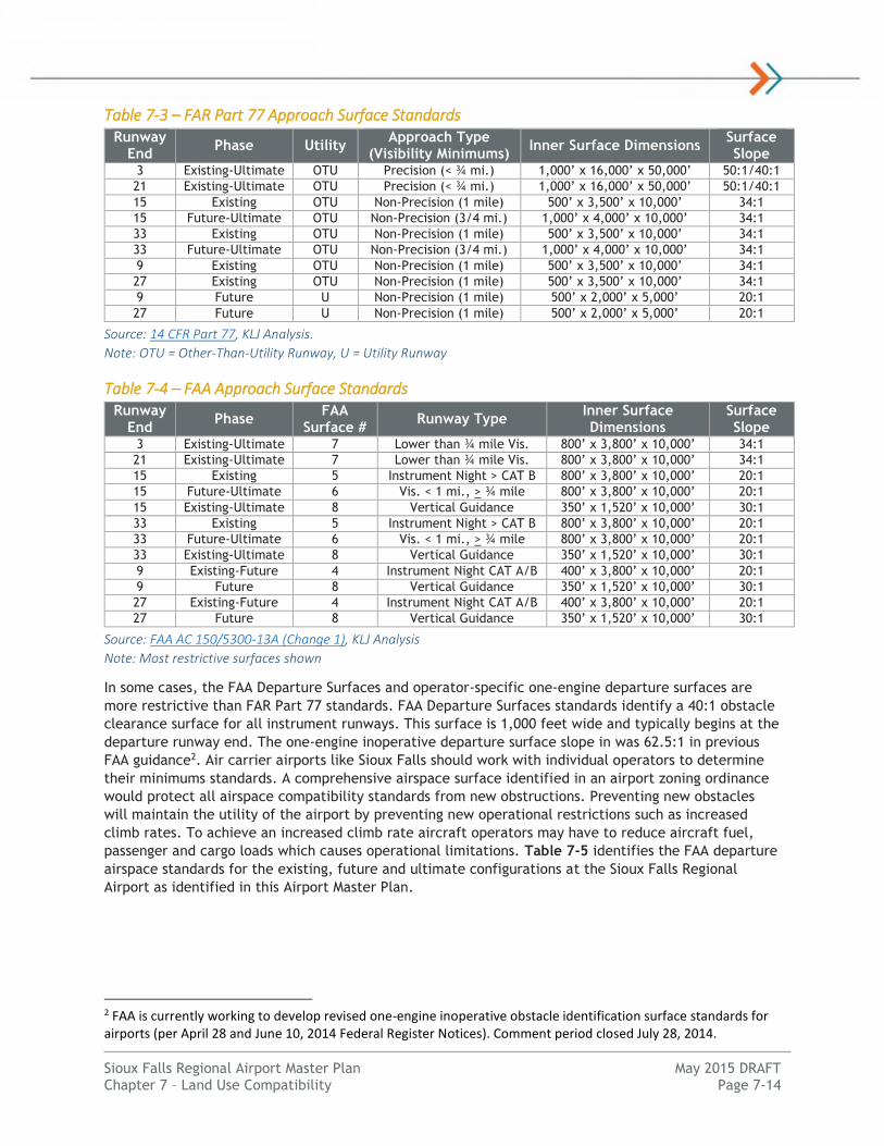
Sioux Falls Regional Airport Master Plan May 2015 DRAFT Chapter 7 – Land Use Compatibility Page 7-14
Table 7-3 – FAR Part 77 Approach Surface Standards Runway
End Phase Utility
Approach Type (Visibility Minimums)
Inner Surface Dimensions Surface Slope
3 Existing-Ultimate OTU Precision (< ¾ mi.) 1,000’ x 16,000’ x 50,000’ 50:1/40:1
21 Existing-Ultimate OTU Precision (< ¾ mi.) 1,000’ x 16,000’ x 50,000’ 50:1/40:1
15 Existing OTU Non-Precision (1 mile) 500’ x 3,500’ x 10,000’ 34:1
15 Future-Ultimate OTU Non-Precision (3/4 mi.) 1,000’ x 4,000’ x 10,000’ 34:1
33 Existing OTU Non-Precision (1 mile) 500’ x 3,500’ x 10,000’ 34:1
33 Future-Ultimate OTU Non-Precision (3/4 mi.) 1,000’ x 4,000’ x 10,000’ 34:1
9 Existing OTU Non-Precision (1 mile) 500’ x 3,500’ x 10,000’ 34:1
27 Existing OTU Non-Precision (1 mile) 500’ x 3,500’ x 10,000’ 34:1
9 Future U Non-Precision (1 mile) 500’ x 2,000’ x 5,000’ 20:1
27 Future U Non-Precision (1 mile) 500’ x 2,000’ x 5,000’ 20:1
Source: 14 CFR Part 77, KLJ Analysis.
Note: OTU = Other-Than-Utility Runway, U = Utility Runway
Table 7-4 – FAA Approach Surface Standards Runway
End Phase
FAA Surface #
Runway Type Inner Surface Dimensions
Surface Slope
3 Existing-Ultimate 7 Lower than ¾ mile Vis. 800’ x 3,800’ x 10,000’ 34:1
21 Existing-Ultimate 7 Lower than ¾ mile Vis. 800’ x 3,800’ x 10,000’ 34:1
15 Existing 5 Instrument Night > CAT B 800’ x 3,800’ x 10,000’ 20:1
15 Future-Ultimate 6 Vis. < 1 mi., > ¾ mile 800’ x 3,800’ x 10,000’ 20:1
15 Existing-Ultimate 8 Vertical Guidance 350’ x 1,520’ x 10,000’ 30:1
33 Existing 5 Instrument Night > CAT B 800’ x 3,800’ x 10,000’ 20:1
33 Future-Ultimate 6 Vis. < 1 mi., > ¾ mile 800’ x 3,800’ x 10,000’ 20:1
33 Existing-Ultimate 8 Vertical Guidance 350’ x 1,520’ x 10,000’ 30:1
9 Existing-Future 4 Instrument Night CAT A/B 400’ x 3,800’ x 10,000’ 20:1
9 Future 8 Vertical Guidance 350’ x 1,520’ x 10,000’ 30:1
27 Existing-Future 4 Instrument Night CAT A/B 400’ x 3,800’ x 10,000’ 20:1
27 Future 8 Vertical Guidance 350’ x 1,520’ x 10,000’ 30:1
Source: FAA AC 150/5300-13A (Change 1), KLJ Analysis
Note: Most restrictive surfaces shown
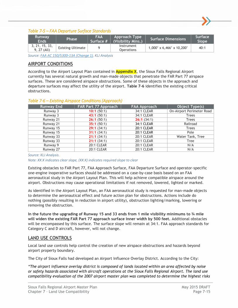
In some cases, the FAA Departure Surfaces and operator-specific one-engine departure surfaces are
more restrictive than FAR Part 77 standards. FAA Departure Surfaces standards identify a 40:1 obstacle
clearance surface for all instrument runways. This surface is 1,000 feet wide and typically begins at the
departure runway end. The one-engine inoperative departure surface slope in was 62.5:1 in previous
FAA guidance2. Air carrier airports like Sioux Falls should work with individual operators to determine
their minimums standards. A comprehensive airspace surface identified in an airport zoning ordinance
would protect all airspace compatibility standards from new obstructions. Preventing new obstacles
will maintain the utility of the airport by preventing new operational restrictions such as increased
climb rates. To achieve an increased climb rate aircraft operators may have to reduce aircraft fuel,
passenger and cargo loads which causes operational limitations. Table 7-5 identifies the FAA departure
airspace standards for the existing, future and ultimate configurations at the Sioux Falls Regional
Airport as identified in this Airport Master Plan.
2 FAA is currently working to develop revised one-engine inoperative obstacle identification surface standards for airports (per April 28 and June 10, 2014 Federal Register Notices). Comment period closed July 28, 2014.
Sioux Falls Regional Airport Master Plan May 2015 DRAFT Chapter 7 – Land Use Compatibility Page 7-15
Table 7-5 – FAA Departure Surface Standards Runway
Ends Phase
FAA Surface #
Approach Type (Visibility Mins.)
Surface Dimensions Surface Slope
3, 21, 15, 33, 9, 27 (All)
Existing-Ultimate 9 Instrument Operations
1,000’ x 6,466’ x 10,200’ 40:1
Source: FAA AC 150/5300-13A (Change 1), KLJ Analysis
AIRPORT CONDITIONS
According to the Airport Layout Plan contained in Appendix X, the Sioux Falls Regional Airport
currently has several natural growth and man-made objects that penetrate the FAR Part 77 airspace
surfaces. These are considered airspace obstructions. Some of these objects in the approach and
departure surfaces may affect the utility of the airport. Table 7-6 identifies the existing critical
obstructions.
Table 7-6 – Existing Airspace Conditions (Approach) Runway End FAR Part 77 Approach FAA Approach Object Type(s)
Runway 3 10:1 (50:1) 34:1 CLEAR On-Airport Perimeter Road
Runway 3 43:1 (50:1) 34:1 CLEAR Trees
Runway 21 26:1 (50:1) 26:1 (34:1) Trees
Runway 21 35:1 (50:1) 34:1 CLEAR Railroad
Runway 15 29:1 (34:1) 20:1 CLEAR Trees
Runway 15 31:1 (34:1) 20:1 CLEAR Pole
Runway 33 21:1 (34:1) 20:1 CLEAR Water Tank, Tree
Runway 33 21:1 (34:1) 20:1 CLEAR Tree
Runway 9 20:1 CLEAR 20:1 CLEAR N/A
Runway 27 20:1 CLEAR 20:1 CLEAR N/A
Source: KLJ Analysis.
Note: XX:X indicates clear slope, (XX:X) indicates required slope to clear
Existing obstacles to FAR Part 77, FAA Approach Surface, FAA Departure Surface and operator-specific
one-engine inoperative surfaces should be addressed on a case-by-case basis based on an FAA
aeronautical study in the Airport Layout Plan. This will help achieve compatible airspace around the
airport. Obstructions may cause operational limitations if not removed, lowered, lighted or marked.
As identified in the Airport Layout Plan, an FAA aeronautical study is requested for man-made objects
to determine the aeronautical effect and future action plan for obstructions. Actions include do
nothing (possibly resulting in reduction in airport utility), obstruction lighting/marking, lowering or
removing the obstruction.
In the future the upgrading of Runway 15 and 33 ends from 1 mile visibility minimums to ¾ mile
will widen the existing FAR Part 77 approach surface inner width by 500 feet. Additional obstacles
will be encompassed by this surface. The surface slope will remain at 34:1. FAA approach standards for
Category C and D aircraft, however, will not change.
LAND USE CONTROLS
Local land use controls help control the creation of new airspace obstructions and hazards beyond
airport property boundary.
The City of Sioux Falls had developed an Airport Influence Overlay District. According to the City:
“The airport influence overlay district is composed of lands located within an area affected by noise
or safety hazards associated with aircraft operations at the Sioux Falls Regional Airport. The land use
compatibility evaluation of the 2007 airport master plan was completed to determine the highest risks

Sioux Falls Regional Airport Master Plan May 2015 DRAFT Chapter 7 – Land Use Compatibility Page 7-16
to properties and protect the community. The
airport influence overlay district includes all or
portions of the approach zone, transition zone,
conical zone and airport noise exposure zone. The
airport influence overlay district is identified as
an overlay district.”
The Airport Influence Overlay District was adopted
in 2007 (City Ordinance 76-07). The Shape Sioux
Falls 2014 Zoning Ordinance was developed
incorporating this Airport Influence Overlay
District. Chapter 160.418 of the City’s Code of
Ordinances acknowledges an airport influence
overlay district from the 2007 Airport Master Plan
as the currently adopted district.
“The intent is to secure safety, promote
health and general welfare of our
community, and to avoid undue
concentration of land where there are
environmental constraints, an airport
influence overlay district has been placed
to address notification aspects of land use
encroachment upon an operating airport.
This shall ensure that the Sioux Falls
Regional Airport is an integral part of the
local community and the national aviation system through the proactive enforcement of the
surrounding land uses.”
The following City of Sioux Falls Code of Ordinances, Title XV: Land Usage zoning chapters identify
airspace regulations:
Chapter 160.419 – Approach Zone
o 50:1 slope for instrument runways; 40:1 for non-instrument runways
Chapter 160.420 – Transition Zones
o 7:1 slope
Chapter 160.421 – Conical Zone
o 150 feet above airport elevation plus a 20:1 slope consistent with FAR Part 77
o Does not limits growth, construction or maintenance of any tree or structure up to 20
feet above the surface of the land
Outside of the Sioux Falls city limits, Minnehaha and Lincoln counties both have zoning ordinances with
airspace controls limiting heights of objects within the approach, transition and conical airspace zones
consistent with language in the City of Sioux Falls zoning. These restrictions apply to joint jurisdiction
areas and County zoning ordinances identified below:
Chapter 158 of the City of Sioux Falls Code of Ordinances, 2006 Joint Zoning Regulations for
Lincoln County and Sioux Falls identify these restrictions for Lincoln County Joint
Extraterritorial Areas.
Chapter 159 of the City of Sioux Falls Code of Ordinances, Comprehensive Extraterritorial
Zoning Regulations and Article 15.13 of the 2002 Revised Joint Zoning Ordinance for Minnehaha
County and the City of Sioux Falls.
Article 15.13 of the 2009 Revised Zoning Ordinance for Lincoln County.
CITY OF SIOUX FALLS
2007 AIRPORT OVERLAY DISTRICT
LS – AIRPORT NOISE EXPOSURE ZONE
Sioux Falls Regional Airport Master Plan May 2015 DRAFT Chapter 7 – Land Use Compatibility Page 7-17
Other structures such as Wind Energy Conversions Systems (WECS) are noted to have height restrictions
compatible with FAA regulations or airport approach zones.
There are no land use controls within the airport overlay district for other activities potentially
impacting aircraft within the airspace including, but not limited to bright lights, smoke or steam
emissions, and electronic interference.
RECOMMENDATIONS
Recommendations to promote airspace compatibility include:
Update the Airport Overlay Zoning Ordinance to help maintain land use compatibility and
promote consistent enforcement between the City of Sioux Falls, Minnehaha County and
Lincoln County jurisdictions.
The airport should take steps to remove existing natural growth obstructions and address man-
made obstacles that penetrate FAR Part 77 and FAA Approach/Departure surfaces. Particular
emphasis should be made to address obstructions to the Runway 21 approach, followed by the
Runway 33 approach surface.
Evaluate the FAA airspace determination for each of the airspace obstructions identified in the
Airport Layout Plan. Work with local landowners, FAA and airport operators to develop an
agreeable solution to address obstructions on a case-by-case basis. Actions may include no
action, lowering, lighting or marking the obstruction.
Work with existing airport operators to identify one-engine inoperative departure surface
requirements. Address existing obstacles to the fullest extent possible. Submit standards to
FAA to incorporate into the FAA airspace review process.
Develop a combined airspace protection surface that considers existing and future FAR Part 77,
FAA Approach/Departure surfaces and operator-specific surfaces.
Update the Airport Overlay Zoning Ordinance District to reflect the combined obstruction
identification surface in cooperation with the City of Sioux Falls, Minnehaha and Lincoln
counties.
In an Airport Overlay Zoning Ordinance update, addressing surrounding land use compatibilities
with aviation operations in the surrounding airspace including controlling activities that cause
pilot glare, impair visibility or create electromagnetic interference.
Consider added language in the Airport Overlay Zoning Ordinance District to require FAA Form
7460-1 Notice of Proposed Construction to be submitted and reviewed by the Airport as part of
the local building permit approval process. Reference South Dakota State law Chapter 50-9-1
requirements. Address follow-up requirements for FAA Form 7460-2 forms to report new
objects to FAA.
Consider including enforcement measures in a future Airport Overlay Zoning Ordinance District
to address new natural-growth objects that penetrate airspace surfaces. If enforcement is not
possible through zoning, acquire avigation easements to provide further protection in areas
where future natural-growth obstructions are identified to penetrate the FAR Part 77 surfaces.
Monitor development of the 60th Street/Minnesota Avenue intersection development. Engage
with the City of Sioux Falls to identify proposed height of new structures. Review compatibility
with current FAA regulations at the time to consider possible operational restrictions.
Implement zoning ordinance prior to roadway development.

Sioux Falls Regional Airport Master Plan May 2015 DRAFT Chapter 7 – Land Use Compatibility Page 7-18
Safety
COMPATIBILITY GUIDELINES
Runway Protection Zones
The Runway Protection Zone (RPZ), is intended to enhance the protection of people and property on
the ground for approach and departure areas beyond the runway end. This is an FAA design standard
identified in FAA AC 150/5300-13A, Airport Design for each runway. FAA guidelines for RPZs were
modified in 2012.
Geometry
This trapezoidal shaped area applies to areas prior to the landing threshold and beyond the runway
departure end. The geometric size is relative to the runway design code (design aircraft) and approach
visibility. The inner width of RPZ ranges from 250 feet to 1,000 feet. The length ranges from 1,000 feet
to 2,500 feet. The RPZ begins 200 feet off the runway end.
The standards for the existing, future and ultimate runway configurations at the Sioux Falls Regional
Airport are identified in Table 7-7. The size of the approach RPZ will increase for Runway 15 and 33 in
the future. When approach visibility minimums reduce from 1 mile to ¾ mile in the future, the inner
width and outer width increases by 500 feet. Portions of the existing and future RPZ for Runway 33 is
located outside airport property line. For Runway 9-27, the future configuration identifies the runway
to be classified for small aircraft which decreases the overall width of the RPZ by 250 feet.
Table 7-7 – FAA RPZ Dimensional Standards
Runway End(s)
Operation Phase Design Code
Distance from End
Inner Width
Outer Width
Length Acres
3-21 Approach Existing-Ultimate D/IV/1600 200’ 1,000’ 1,750’ 2,500’ 78.914
3-21 Departure Existing-Ultimate D/IV 200’ 500’ 1,010’ 1,700’ 29.465
15-33 Approach Existing D/IV/5000 200’ 500’ 1,010’ 1,700’ 29.465
15-33 Approach Future-Ultimate D/IV/4000 200’ 1,000’ 1,510’ 1,700’ 48.978
15-33 Departure Existing-Ultimate D/IV 200’ 500’ 1,010’ 1,700’ 29.465
9-27 Approach Existing B/II/5000 200’ 500’ 700’ 1,000’ 13.770
9-27 Approach Future B/II/5000 (Small)
200’ 250’ 450’ 1,000’ 8.035
9-27 Departure Existing-Future B/II 200’ 250’ 450’ 1,000’ 8.035
Source: FAA AC 150/5300-13A, KLJ Analysis
The RPZ is divided into two zones, the “central portion of the RPZ” and the “controlled activity area”.
The Central Portion of the RPZ is the area within the width of the Runway Object Free Area (ROFA)
extended. The Controlled Activity Area (CAA) includes the areas of the RPZ outside of the central
portion.
Control
Where practical, the FAA strongly recommends that airport sponsors own the complete approach and
departure RPZ area in fee simple title. This enables the sponsor to fully control all development and
activity with the RPZ. If this is not practical, the sponsor is expected to control land use and activities
in the RPZ through easements, leases, zoning, or restrictive covenants that provide for height
restrictions and restrict current and future use of the land surface to preclude incompatible uses. The
sponsor is also expected to take all possible measures to remove or mitigate incompatible land uses.
Acceptable or Compatible Land Uses
The ultimate goal is to clear the entire RPZ of all above-ground objects. Where this is impractical,
airport owners, as a minimum, must clear the RPZ of incompatible objects and activities. Some uses
are permitted in the CAA, provided they do not attract wildlife, are outside of the central portion of
Sioux Falls Regional Airport Master Plan May 2015 DRAFT Chapter 7 – Land Use Compatibility Page 7-19
the RPZ and do not interfere with navigational aids. FAA AC 150/5300-13A provides for some land uses
in the RPZ that are permissible without further evaluation:
Farming or agricultural activities that meet airport design standards
Irrigation channels that meet the requirements of AC 150/5200-33 Hazardous Wildlife
Attractants On or Near Airports and FAA/USDA manual, Wildlife Hazard Management at
Airports
Airport service roads, as long as they are not public roads and are directly controlled by the
airport operator
Underground facilities, as long as they meet other design criteria, such as RSA requirements, if
applicable
Unstaffed NAVAIDs and facilities, such as equipment for airport facilities that are considered
fixed-by-function in regard to the RPZ
Unacceptable or Incompatible Land Uses
The FAA had previously identified a number of activities that are considered incompatible within the
RPZ. Those activities include:
Fuel handling and storage facilities (except that underground fuel tanks are allowed in the
CAA)
Facilities that generate smoke, dust, or other plumes
Facilities with misleading lights or that create glare
Any land use or activity that attracts wildlife
Residences and places of public assembly (churches, schools, hospitals, office buildings,
shopping centers, etc.)
On September 27, 2012, the FAA issued interim guidance on land use within an RPZ. The interim
guidance clarifies specific land uses that are not permissible inside the RPZ, but the guidance does not
apply to existing land uses. The guidance requires coordination with the FAA if certain land uses enter
the RPZ as a result of:
An airfield project (e.g., runway extension, runway shift)
A change in the critical design aircraft that increases the RPZ dimensions
A new or revised instrument approach procedure that increases the RPZ dimensions
A local development proposal in the RPZ (either new or reconfigured)
The following land uses are considered incompatible in the RPZ and must be coordinated with the FAA
as identified in Table 1 from the FAA’s Interim RPZ Guidance:
Buildings and structures (Examples include, but are not limited to: residences, schools,
churches, hospitals or other medical care facilities, commercial/industrial buildings, etc.)
Recreational land use (Examples include, but are not limited to: golf courses, sports fields,
amusement parks, other places of public assembly, etc.)
Transportation facilities. Examples include, but are not limited to:
o Rail facilities – light or heavy, passenger or freight
o Public roads/highways
o Vehicular parking facilities
Fuel storage facilities (above and below ground)
Hazardous material storage (above and below ground)
Wastewater treatment facilities
Above-ground utility infrastructure (i.e. electrical substations), including any type of solar
panel installations.
Sioux Falls Regional Airport Master Plan May 2015 DRAFT Chapter 7 – Land Use Compatibility Page 7-20
RPZ Alternative Analysis
The FAA interim guidance requires an analysis of alternatives be conducted before coordinating with
the FAA if any of the land uses, described above, would be introduced into the new or modified RPZ.
This analysis includes the identification and documentation of the full ranges of alternatives that
could:
Avoid introducing the land use issue within the RPZ.
Minimize the impact of the land use in the RPZ (i.e., routing a new roadway through the
controlled activity area, move farther away from the runway end, etc.).
Mitigate risk to people and property on the ground (i.e., tunneling, depressing and/or
protecting a roadway through the RPZ, implement operational measures to mitigate any risks,
etc.).
The FAA guidance recommends that the documentation of the alternatives should include:
A description of each alternative, including a narrative discussion and exhibits or figures
depicting the alternative.
Full cost estimates associated with each alternative regardless of potential funding sources.
A practicability assessment based on the feasibility of the alternative in terms of cost,
constructability, and other factors.
Identification of the preferred alternative that would meet the project purpose and need while
minimizing risk associated with the location within the RPZ.
Identification of all Federal, State, and local transportation agencies involved or interested in
the issue.
Analysis of the specific portion(s) and percentages of the RPZ affected, drawing a clear
distinction between the Central Portion of the RPZ versus the Controlled Activity Area, and
clearly delineating the distance from the runway end and runway landing threshold.
Analysis of (and issues affecting) sponsor control of the land within the RPZ.
Any other relevant factors for FAA consideration.
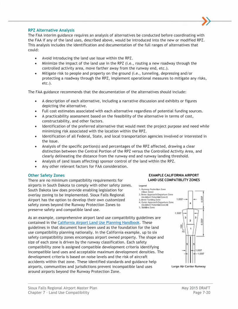
Other Safety Zones
There are no minimum compatibility requirements for
airports in South Dakota to comply with other safety zones.
South Dakota law does provide enabling legislation for
overlay zoning to be implemented. Sioux Falls Regional
Airport has the option to develop their own customized
safety zones beyond the Runway Protection Zones to
preserve safety and compatible land use.
As an example, comprehensive airport land use compatibility guidelines are
contained in the California Airport Land Use Planning Handbook. These
guidelines in that document have been used as the foundation for the land
use compatibility planning nationally. In the California example, up to six
safety compatibility zones encompass airport owned property. The shape and
size of each zone is driven by the runway classification. Each safety
compatibility zone is assigned compatible development criteria identifying
incompatible land uses and acceptable maximum development densities. The
development criteria is based on noise levels and the risk of aircraft
accidents within that zone. These identified standards and guidance help
airports, communities and jurisdictions prevent incompatible land uses
around airports beyond the Runway Protection Zone.
EXAMPLE CALIFORNIA AIRPORT
LAND USE COMPATIBLITY ZONES
Sioux Falls Regional Airport Master Plan May 2015 DRAFT Chapter 7 – Land Use Compatibility Page 7-21
Wildlife Hazards
The presence of wildlife in an around an airport can be a significant concern for aircraft operations. A
wildlife strike on the ground or in the air has the potential to cause catastrophic damage to life and
property. Hazardous wildlife around airports may include but are not limited to ground mammals such
as deer or avian species including geese. Compatibility standards include controlling land uses to
reduce the risk of existing hazards and controlling the creation of new wildlife hazards.
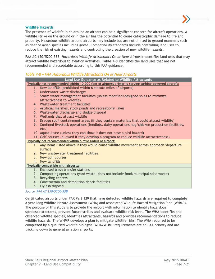
FAA AC 150/5200-33B, Hazardous Wildlife Attractants On or Near Airports identifies land uses that may
attract wildlife hazardous to aviation activities. Table 7-8 identifies the land uses that are not
recommended and acceptable according to this FAA guidance.
Table 7-8 – FAA Hazardous Wildlife Attractants On or Near Airports Land Use Guidance as Related to Wildlife Attractants
Typically not recommended within 10,000 feet of airports primarily serving turbine-powered aircraft:
1. New landfills (prohibited within 6 statute miles of airports) 2. Underwater waste discharges
3. Storm water management facilities (unless modified/designed so as to minimize attractiveness to wildlife)
4. Wastewater treatment facilities
5. Artificial marshes, stock ponds and recreational lakes
6. Wastewater discharge and sludge disposal 7. Wetlands that attract wildlife
8. Dredge spoil containment areas (if they contain materials that could attract wildlife)
9. Confined livestock operations (feedlots, dairy operations hog/chicken production facilities, etc.)
10. Aquaculture (unless they can show it does not pose a bird hazard) 11. Golf courses (allowed if they develop a program to reduce wildlife attractiveness)
Typically not recommended within 5 mile radius of airport:
1. Any items listed above if they would cause wildlife movement across approach/departure surface.
2. New wastewater treatment facilities
3. New golf courses
4. New landfills
Typically compatible with airports:
1. Enclosed trash transfer stations
2. Composting operations (yard waste; does not include food/municipal solid waste) 3. Recycling centers
4. Construction and demolition debris facilities
5. Fly ash disposal
Source: FAA AC 150/5200-33B
Certificated airports under FAR Part 139 that have detected wildlife hazards are required to complete
a year-long Wildlife Hazard Assessment (WHA) and associated Wildlife Hazard Mitigation Plan (WHMP).
The purpose of this study is to provide the airport with information to identify hazardous
species/attractants, prevent future strikes and evaluate wildlife risk level. The WHA identifies the
observed wildlife species, identifies attractants, hazards and provides recommendations to reduce
wildlife hazards. The WHMP develops a plan to mitigate wildlife risks. The WHA required to be
completed by a qualified wildlife biologist. WHA/WHMP requirements are an FAA priority and are
trickling down to general aviation airports.
Sioux Falls Regional Airport Master Plan May 2015 DRAFT Chapter 7 – Land Use Compatibility Page 7-22
AIRPORT CONDITIONS
Runway Protection Zones
The existing RPZs were evaluated to determine existing land uses and airport control. A graphical
illustration of the RPZs is identified in Exhibit 7-9 on the following page. Within the off-airport RPZ
areas there are various classified land uses. Runway 3 contains Conservation (CN) district with the
Elmwood Golf Course. The Runway 21 RPZ contains Conservation (CN), Recreational (REC) and
Agricultural (AG) districts. Existing development within the Runway 21 RPZ is classified as light
Industrial (I-1). The existing Runway 33 RPZ has zoning districts classified as light Industrial (I-1) and a
small portion of neighborhood Commercial (C-2). The existing and future Runway 15, 9 and 27 RPZs are
contained on-airport.
The Runway 21 RPZ contains a portion of an industrial structure and the Runway 15 RPZ contains a
small portion of a commercial building. Both structures are located off-airport without direct airport
land use control.
Existing land uses within the RPZ may remain provided they are determined to be compatible by FAA.
As of this Master Plan, the Airport is not aware of the FAA identifying any existing land use as
incompatible. The RPZ size and the structures within the Runway 21 RPZ, for example, has safely
existed for over 10 years and several FAA-funded projects have been completed during that time.
One identified Airport Master Plan project that would require an FAA coordination and an FAA
Alternatives Analysis would be enhancing the Runway 33 approach to ¾ mile visibility minimums. This
would increase the size of the RPZ into new structures and industrial zoned areas. New land uses
identified in Table 1 of the interim guidance would be introduced. No formal RPZ alternatives analysis
was completed for this Airport Master Plan as the projects are proposed beyond the short-term (0-5
year) implementation timeframe.
Future bike trails are proposed to connect to an existing Sioux Falls Trail outside of the RPZ.
Wildlife Hazards
Existing wildlife elements in and around the airport were reviewed. A Wildlife Hazard Assessment
(WHA) was completed from 2013-2014. The associated Wildlife Hazard Management Plan (WHMP) is
scheduled to be completed in 2015.
The airport has been pro-active in addressing wildlife issues by eliminating airfield crops, replacing the
perimeter fence and removing on-airport trees. Waterfowl, including Canada geese have been the most
significant wildlife hazard at the airport due to the presence of surrounding off-airport cropland and
open water. Larger bodies of open water includes the Big Sioux River and Diversion Channel as well as
Sweetman’s Quarry within the Runway 3 approach approximately 7,500 feet from the end of the
runway. There are a few wetlands or drainage areas within airport property that attract wildlife
including ducks. The airport will continue to address on-airport hazards, and off-airport hazards within
their control.
The Sioux Falls Regional Sanitary Landfill (SFRSL), the largest in South Dakota began operations in 1979
and is located 5 miles west of Sioux Falls, or 8 miles southwest of the airport. The Sioux Falls
Stockyards closed in 2009. Any remaining stockyards within the City of Sioux Falls are largely or
entirely enclosed with a roof, located 1 mile southeast of Runway 33 end. These land uses are
compatible.
Sioux Falls Regional Airport Master Plan May 2015 DRAFT Chapter 7 – Land Use Compatibility Page 7-23
Exhibit 7-9 – Existing Runway Protection Zones (Approach)
Runway End RPZ Size Existing Land Uses Off-Airport Control Runway 9 500’ x 700’ x 1,000’ Aeronautical, Agricultural N/A - Entire RPZ On-Airport
Runway 27 500’ x 700’ x 1,000’ Aeronautical, Agricultural N/A - Entire RPZ On-Airport
Runway 15 500’ x 1,010’ x 1,700’ Agricultural, Bike Trail Public Right-of-Way
Runway 33 500’ x 1,010’ x 1,700’ Agricultural, Roads, Above-
Ground Utility Infrastructure, Commercial Building (partial)
Public Right-of-Way
Runway 3 1,000’ x 1,750’ x 2,500’ Road, Golf Course Clear Zone Easement, Public
Right-of-Way
Runway 21 1,000’ x 1,750’ x 2,500’ Agricultural, Roads, Railroad, Bike Trail, Industrial Building
(partial) Clear Zone Easement
Source: KLJ Analysis
RUNWAY 9 - RPZ
RUNWAY 27 - RPZ
RUNWAY 15 - RPZ
RUNWAY 33 - RPZ
RUNWAY 21 - RPZ
RUNWAY 3 - RPZ
Clear Zone Easement Clear Zone Easement
Industrial Building Elmwood Golf Course
Bike Trail Commercial Building
Bike Trail
Utility Infrastructure
Central Portion of the RPZ Central Portion of the RPZ
Central Portion of the RPZ Central Portion of the RPZ
Central Portion of the RPZ Central Portion of the RPZ

Sioux Falls Regional Airport Master Plan May 2015 DRAFT Chapter 7 – Land Use Compatibility Page 7-24
LAND USE CONTROLS
There is limited local land use controls help control the creation of new land use incompatibilities
beyond airport property boundary. Land use safety controls exist within the City of Sioux Falls only.
Chapter 160.418 of the City’s Code of Ordinances acknowledges that when a zoning district changes or
zoning permit within the airport influence overlay district shall abide by the following safety standards:
Residentially platted lots as of June 28, 2007 are allowed to remain and apply for residential
zoning permits.
Office, Institutional and Live/Work zoning districts shall be developed with three conditions:
1. The parcel contains three acres of land or less;
2. The building contains 50,000 square feet of area or less; and
3. Signed acknowledgement of the airport influence overlay district
Commercial and Industrial zoning districts shall provide written documentation from the
Airport that occupancy standards meet FAA regulations.
Agricultural, Recreational and Conservation zoning districts must provide a mitigation plan
approved by the Airport which addresses wildlife attractants per FAA AC 150/5200-33B.
Chapter 160.423 provides the option for the Airport to receive conveyance of an avigation easement.
According to the zoning ordinance: “within the airport influence overlay district, an avigation
easement may be conveyed to the Airport by property owners subdividing lands, initiating substantial
construction of any habitable structure on already divided lands, or changing zones within the airport
influence overlay district. The Airport shall be the grantees of the easement, and shall be able to
facilitate an agreed upon easement between the two parties.” To date this provision has not been
enforced by the City of Sioux Falls.
There are limited provisions to prevent the creation of new wildlife hazards.
RPZ ALTERNATIVES ANALYSIS
RPZ Alternative Analysis Process
The existing Runway 3 and 21 RPZs for the Sioux Falls Regional Airport are not being modified by the
planned development. The RPZs for Runway 9 and 27 are proposed to reduce in size in the future
within the footprint of the existing RPZ. Therefore, the FAA’s Interim Guidance is not triggered by the
development and no additional analysis is required for these runway ends.
The Runway 15 RPZ is proposed to increase in size in the long-term because of an upgrade to ¾ mile
visibility minimums. The airport owns the land within the modified RPZ and there are no incompatible
land uses, as identified in the FAA’s Interim Guidance, within the modified Runway 15 RPZ. Therefore,
no alternative analysis is required.
The RPZ land use alternative analysis is required by the FAA for Runway 33 to upgrade visibility
minimums to ¾ mile. This would increase the size of the RPZ. The project is proposed beyond the
initial planning period of 0-5 years as identified in Chapter 6: Implementation Plan. Therefore, a
simple planning-level alternatives review was completed in Chapter 5: Alternatives Analysis. A formal
FAA RPZ analysis will be completed at a later time when the project is in the planning stage and within
five years of implementing.
Runway 33 RPZ Alternatives Review
Existing RPZ
The “project” is to upgrade the Runway 33 approach to lower visibility minimums from 1 mile to ¾
mile. The project triggers an expanded RPZ from 500’ x 1,010’ x 1,700 to 1,000’ x 1,510’ x 1,700’

Sioux Falls Regional Airport Master Plan May 2015 DRAFT Chapter 7 – Land Use Compatibility Page 7-25
approach RPZ. There are several land uses within the proposed expanded Runway 33 RPZ that trigger
FAA coordination and may be incompatible. They include:
1. Minnesota Avenue
2. Mark Juhl Auto Sports & Services (portion)
3. Algonquin Street
4. Electrical sub-station (portion)
Proposed RPZ
The “project” is to upgrade the Runway 33 approach to lower visibility minimums from 1 mile to ¾
mile. The project triggers an expanded approach RPZ of 1,000’ x 1,510’ x 1,700’ in size. There are
several land uses that are introduced into the proposed RPZ that trigger FAA coordination and may be
incompatible. They include:
5. Sioux Falls Water Tank
6. Railroad
7. Minnesota Avenue – additional roadway length
8. Electrical sub-station – additional area
Alternatives Analysis
This section identifies the available alternatives that are being considered to address potential
incompatible land uses in the RPZs. Each alternative is broadly analyzed to determine the feasibility,
cost, and practicability of implementation. Exhibit 7-10 and 7-11 graphically illustrate the
alternatives and Table 7-12 summarizes the alternatives review.
Exhibit 7-10 – Runway 33 RPZ Overall Alternatives Map
Source: KLJ Analysis, Google Earth
NORTH
No Scale
Alternative 9
Alternative 5
Alternative 6
2
Alternative 4
Alternative 1
Alternative 2
Alternative 7
3
1
4
5 6
7 8
Alternative 8
Alternative 3

Sioux Falls Regional Airport Master Plan May 2015 DRAFT Chapter 7 – Land Use Compatibility Page 7-26
Exhibit 7-11 – Runway 33 RPZ Alternatives
Source: KLJ Analysis
No preferred alternative is recommended in this analysis as the proposed project is not identified
in the near-term. For a preferred alternative to be recommended the overall benefit of the proposed
project needs to be evaluated against the operational and financial costs of mitigating land uses from
the RPZ. This should be evaluated as the project is within five years of implementing. This may require
an update to the Airport Master Plan/Airport Layout Plan at that time.
ALTERNATIVE 1: NO ACTION
2
3
1
4
ALTERNATIVE 2/3: EXPAND RPZ
5
6
7 8
3
1
ALTERNATIVE 4: SHIFT RPZ (99’) – NO PROJECT
3
1
Alt. 3: Remove
Objects #2, #4
ALTERNATIVE 5/6: SHIFT RPZ (99’)
Alt. 6: Remove
Object #5
6
7
3
1
5
ALTERNATIVE 7: SHIFT/CLEAR RPZ
Remove All
Objects From RPZ,
Relocate Road
ALTERNATIVE 8/9: SHIFT RPZ TO CLEAR
Alt. 8: Shift 1,099’ – No Project
Alt. 9: Shift 1,299’
Sioux Falls Regional Airport Master Plan May 2015 DRAFT Chapter 7 – Land Use Compatibility Page 7-27
Table 7-12 – Runway RPZ Alternatives Review
Alt Actions* RPZ
Objects
Factors Runway Design
Cost Feasibility Practicality Rwy 33
LDA Rwy 15 TORA
Visib. Mins.
1 Do Nothing - No
Project 1 – 4 1 5 4 7,999’ 7,999’ 1 mile
2 Implement Project 1 – 8 1 5 5 7,999’ 7,999’ ¾ mile
3 Remove Object #2, #4 1, 3, 5-8 3 3 3 7,999’ 7,999’ ¾ mile
4 Shift Runway 33 End
(99’) – No Project 1, 3 2 5 3 7,900’ 7,900’ 1 mile
5 Shift Runway 33 End
(99’) 1, 3, 5, 7 2 5 3 7,900’ 7,900’ ¾ mile
6 Alt. 5 + Relocate Water Tank (#5)
1, 3, 7 4 3 2 7,900’ 7,900’ ¾ mile
7
Shift Runway 33 End (399’), Relocate Minnesota Ave. &
Water Facility
None 5 1 1 7,600’ 7,600’ ¾ mile
8 Shift Runway 33 End (1,099’) – No Project
None 3 5 1 6,900’ 6,900’ 1 mile
9 Shift Runway 33 End
(1,299’) None 3 5 2 6,700’ 6,900’ ¾ mile
Source: KLJ Analysis
Note: Cost, Feasibility and Practicality Factor based on 1 (low) through 5 (high), TORA = Takeoff Run Available, LDA =
Landing Distance Available, *Project assumed to be implemented unless otherwise stated.
Assuming the project has strong justification & need, it does appear shifting the runway by
approximately 100 feet identified in Alternative 4 would remove an existing structure and above-
ground utility infrastructure for the existing and ultimate Runway 33 RPZ configuration. This associated
runway modification is not anticipated to have a significant impact to operational capability of the
airport, but would require reconfiguration of runway infrastructure including runway and taxiway
pavement and lighting to implement.
RECOMMENDATIONS
Recommendations to promote safety compatibility include:
Overall
Update the Airport Overlay Zoning Ordinance to help maintain land use compatibility and
promote consistent enforcement between the City of Sioux Falls, Minnehaha County and
Lincoln County jurisdictions.
Runway Protection Zones
Obtain land use compatibility concurrence from FAA on structures within the existing Runway
21 and 33 RPZs.
Acquire a clear zone avigation easement within off-airport areas of the existing Runway 21
RPZ, and the existing-future Runway 33 RPZ area. This will prevent the creation of new
hazards. It is not feasible for the airport to purchase these areas in fee simple because of
existing development.
Consider protecting land uses in the next Airport Overlay Zoning Ordinance update within the
existing and future Runway Protection Zones. This is especially critical if a clear zone avigation
easement cannot be acquired by the airport. Any development proposal in an existing of future
RPZ should require Airport and subsequent FAA review to meet FAA guidelines.

Sioux Falls Regional Airport Master Plan May 2015 DRAFT Chapter 7 – Land Use Compatibility Page 7-28
Complete a Runway Protection Zone Alternatives Analysis for the expansion of Runway 33 RPZ
within five years of when the visibility minimums are proposed to be lowered to ¾ mile.
Other Safety Zones
Consider protecting land uses in the next Airport Overlay Zoning Ordinance update beyond the
Runway Protection Zones. Any zones should be established risk-based standards such as from
the California Land Use Compatibility Guidebook. Land uses may be restricted based on use and
density as to not create new aviation hazards.
Wildlife Hazards
Implement the recommendations of the WHA/WHMP completed for the Sioux Falls Regional
Airport for specific areas of concern for wildlife hazards.
Land uses should be restricted through the local zoning, plan review and permitting process to
reduce the risk of wildlife strikes. Elements should be identified in a future Airport Overlay
Zoning Ordinance. The zoning should allow for the prevention of new wildlife hazards and allow
for reasonable mitigation techniques to be implemented for existing identified hazards.
Noise
COMPATIBILITY GUIDELINES
The Sioux Falls Regional Airport currently has zoning regulations addressing airport noise impacts from
year 2005 and 2025 based on the 2007 Airport Master Plan. This zoning helps mitigate the impact of
new incompatible land uses by acknowledging airport noise impacts through an avigation easement on
residential structures.
In this 2013 Airport Master Plan, a planning-level noise impact study was completed using the FAA’s
Integrated Noise Model (INM) software. This was completed because airport noise analysis are typically
needed for environmental impact purposes at airports with 700 or more annual jet operations or 90,000
annual propeller operations. The review will assist with land use compatibility planning.
Land use compatibility standards for noise are identified in FAA AC 150/5020-1, Noise Control and
Compatibility Planning for Airports. Table 7-13 on the following page identifies the land use
compatibility standards relative to different calculated DNL sound levels.
Sioux Falls Regional Airport Master Plan May 2015 DRAFT Chapter 7 – Land Use Compatibility Page 7-29
Table 7-13 – Land Use Compatibility Recommendations for Noise
Land Use Yearly Day-Night Average Sound Level (Ldn) in decibels
Below 65 65-70 70-75 75-80 80-85 Over 85
Residential
Residential, other than mobile
homes and transient lodgings YES NO (1) NO (1) NO NO NO
Mobile home parks YES NO NO NO NO NO
Transient lodgings YES NO (1) NO (1) NO (1) NO NO
Public Use
Schools YES NO (1) NO (1) NO NO NO
Hospitals and nursing homes YES 25 30 NO NO NO
Churches, auditoriums, and
concert halls YES 25 30 NO NO NO
Government Services YES YES 25 30 NO NO
Transportation YES YES YES (2) YES (3) YES (4) YES (4)
Parking YES YES YES (2) YES (3) YES (4) NO
Commercial Use
Offices, business and professional YES YES 25 30 NO NO
Wholesale and retail- building
materials, hardware and farm
equipment
YES YES YES (2) YES (3) YES (4) NO
Retail trade-general YES YES 25 30 NO NO
Utilities YES YES YES (2) YES (3) YES (4) NO
Communication YES YES 25 30 NO NO
Manufacturing and Production
Manufacturing, general YES YES YES (2) YES (3) YES (4) NO
Photographic and optical YES YES 25 30 NO NO
Agriculture (except livestock) and
forestry YES YES (6) YES (7) YES (8) YES (8) YES (8)
Livestock farming and breeding YES YES (6) YES (7) NO NO NO
Mining and fishing, resource
production and extraction YES YES YES YES YES YES
Recreational
Outdoor sports arenas and
spectator sports YES YES (5) YES (5) NO NO NO
Outdoor music shells,
amphitheaters YES NO NO NO NO NO
Nature exhibits and zoos YES YES NO NO NO NO
Amusements, parks, resorts, and
camps YES YES YES NO NO NO
Golf courses, riding stables and
water recreation YES YES 25 30 NO NO
Source: FAA Environmental Desk Reference – Compatible Land Use derived from FAA AC 150/5020-1

Sioux Falls Regional Airport Master Plan May 2015 DRAFT Chapter 7 – Land Use Compatibility Page 7-30
Table 7-12 Notes: Green shaded cells within 65 DNL and above are compatible land uses for the study airport, Red
shaded cells are not compatible without acceptable mitigation. YES = Land Use and related structures compatible
without restrictions, NO = Land Use and related structures not compatible and should be prohibited. NLR = Noise
Level Reduction (outdoor to indoor) to be achieved through incorporation of noise attenuation into the design and
construction of the structure. 25, 30 or 35 = Land use and related structures generally compatible; measures to
achieve NLR of 25, 30 or 35 Db must be incorporated into design and construction of structure.
(1) Where the community determines that residential or school uses must be allowed, measures to achieve outdoor
to indoor Noise Level Reduction (NLR) of at least 25 dB and 30 dB should be incorporated into building codes and be
considered in individual approvals. Normal residential construction can be expected to provide a NLR of 20 dB, thus,
the reduction requirements are often stated as 5, 10 or 15 dB over standard construction and normally assume
mechanical ventilation and closed windows year round. However, the use of NLR criteria will not eliminate outdoor
noise problems.
(2) Measures to achieve NLR of 25 dB must be incorporated into the design and construction of portions of these
buildings where the public is received, office areas, noise sensitive areas or where the normal noise level is low.
(3) Measures to achieve NLR of 25 dB must be incorporated into the design and construction of portions of these
buildings where the public is received, office areas, noise sensitive areas or where the normal noise level is low.
(4) Measures to achieve NLR of 35 dB must be incorporated into the design and construction of portions of these
buildings where the public is received, office areas, noise sensitive areas or where the normal noise level is low.
(5) Land use compatible provided special sound reinforcement systems are installed.
(6) Residential buildings require an NLR of 25.
(7) Residential buildings require an NLR of 30.
(8) Residential buildings not permitted.
NOISE ANALYSIS
Introduction
The Sioux Falls Regional Airport Authority as the airport owner has elected to complete an airport noise
analysis as part of this Airport Master Plan to determine the existing and future impacts of aircraft
noise upon land uses surrounding FSD. A technical airport noise analysis was completed for airport
planning purposes to determine the existing and proposed noise exposure levels for surrounding land
use compatibility. These noise exposure contours utilized the Master Plan for the future airport runway
configuration and activity at the Sioux Falls Regional Airport.
The airport noise analysis was prepared using the FAA’s approved computer model, the Integrated
Noise Model (INM) version 7.0d software program, for developing noise exposure contours. The FAA-
approved activity forecasts were used for this study along with existing and future runway
configuration and use patterns.
Methodology
Noise is most commonly defined as any unwanted sound. Noise is measured as sound pressure level
expressed in decibels (dB). The number of pressure waves per second of a sound is the frequency of
sound. Noise measurements of point sources are adjusted to approximate the normal human perception
of noise. Measurements made with this weighing system are known as “A-weighted” defined as “dBA”.
The FAA evaluates noise based on converting the equivalent sound energy from fluctuating noise to a
constant level of sound over a defined period of time. The metric is called the equivalent sound level
(Leq).
The noise level metric used to determine the airport operational noise levels is the day-night average
sound level (DNL). The DNL provides a single noise level that represents a full 24-hour day, 365-day
annual period. This takes into account a greater sensitively to nighttime occurring noise between 10
p.m. and 7 a.m. The DNL metric is recognized by FAA as the appropriate measure of cumulative noise
exposure.
Sioux Falls Regional Airport Master Plan May 2015 DRAFT Chapter 7 – Land Use Compatibility Page 7-31
As a frame of reference, normal human conversation ranges between 45 and 65 dBA. The California
Department of Health Sciences has determined that residential low density sound levels that are
normally acceptable are up to 60 dBA, with levels up to 70 dBA identified as conditionally acceptable
where the outdoor environment would seem noisy.
The INM develops a set of grid points at the ground level around the airport. The program then
determines slant distance from the point to each flight track, and determines the noise exposure based
on aircraft type, operational, and engine characteristics. The INM aircraft database includes noise,
thrust settings, and flight profile data used for noise modeling based on years of research and field
measurements by FAA. The noise exposures levels are summed and the cumulative noise exposure
contours are developed using the DNL metric.
Inputs
Various user input data is required to run a successful noise study through INM. This includes physical
and metrological data about the airport, ground track data, aircraft operational data, and the
assignment of these aircraft to the flight tracks. Approved aviation activity estimates and forecasts
from the Master Plan were utilized. Consultant staff worked closely with FSD Airport Management and
Airport Traffic Control Tower staff to develop airport operational modeling inputs.
Operations and Fleet Mix
The selection of aircraft types is a critical step in the INM process. The airport’s existing and future
DNL were calculated from FAA-approved aviation forecasts derived from this Airport Master Plan.
Operations were split into local and itinerant based on operation counts and activity forecasts. The
existing 2013 and forecast 2033 FSD aircraft activity from the Airport Master Plan with operational fleet
mix estimates is summarized in Table 7-14.
Table 7-14 – INM Aircraft Activity Levels
Aircraft Type INM Code Operations Percent of Total
2013 2033 2013 2023
ITINERANT OPERATIONS
Air Carrier/Air Taxi (Airlines)
Airbus A320-200 A320-232 1,599 1,226 10.0% 6.0%
Boeing 717-200 717200 0 3,066 0.0% 15.0%
Boeing 737-800 737800 0 204 0.0% 1.0%
Boeing MD-83 MD83 1,039 1,124 6.5% 5.5%
Boeing 757-200 757PW 40 51 0.25% 0.25%
Boeing 767-200 767CF6 40 51 0.25% 0.25%
Bombardier CRJ-200 CRJ9-ER 5,116 2,862 32.0% 14.0%
Bombardier CRJ-700/900 CRJ9-ER 1,119 2,862 7.0% 14.0%
Embraer EMB-145 EMB145 6,715 4,088 42.0% 20.0%
Embraer ERJ-175 ERJ170 320 4,088 2.0% 20.0%
Embraer ERJ-190 ERJ190 0 818 0.0% 4.0%
Subtotal 15,989 20,441 100.0% 100.0%
Sioux Falls Regional Airport Master Plan May 2015 DRAFT Chapter 7 – Land Use Compatibility Page 7-32
Aircraft Type INM Code Operations Percent of Total
2013 2033 2013 2023
Air Carrier/Air Taxi (Cargo)
Airbus A300-600F A300-622R 334 0 2.3% 0.0%
Aerospatiale ATR-42/72 DHC8 610 1,472 4.2% 7.4%
Beechcraft B1900 1900D 3,965 6,542 27.2% 32.9%
Boeing 767-300F 767CF6 672 1,239 4.6% 6.2%
Boeing 757-200F 757PW 1,376 2,302 9.4% 11.6%
Boeing 727-200F 727EM2 16 0 0.1% 0.0%
Bombardier CRJ-200 CRJ9-ER 0 654 0.0% 3.3%
Cessna Caravan 208 CNA208 1,220 1,636 8.4% 8.2%
Embraer EMB-120 EMB120 0 1,636 0.0% 8.2%
Fairchild Metroliner III DHC6 3,965 2,453 27.2% 12.3%
Multi-Engine Piston BEC58P 2,440 1,953 16.7% 9.9%
Subtotal 14,598 19,987 100.0% 100.0%
Air Taxi (Other Commercial)
Single-Engine Piston Variable GASEPV 96 156 2.0% 2.0%
Single-Engine Piston Fixed GASEPF 96 156 2.0% 2.0%
Multi-Engine Piston BEC58P 964 1,563 20.0% 20.0%
Turboprop (Cessna 441) CNA441 2,650 4,299 55.0% 55.0%
Turbojet (Cessna 525) CNA525C 675 1,094 14.0% 14.0%
Turbojet (Cessna 560XL) CNA560XL 241 391 5.0% 5.0%
Turbojet (Falcon 200) FAL200 48 78 1.0% 1.0%
Helicopter (Eurocopter 130) EC130 48 78 1.0% 1.0%
Subtotal 4,819 7,817 100.0% 100.0%
General Aviation
Single-Engine Piston Variable GASEPV 1,223 1,983 6.0% 6.0%
Single-Engine Piston Fixed GASEPF 1,233 1,983 6.0% 6.0%
Multi-Engine Piston BEC58P 2,445 3,305 12.0% 10.0%
Turboprop CNA441 11,004 17,847 54.0% 54.0%
Turbojet (Cessna 525) CNA525C 1,426 2,644 7.0% 8.0%
Turbojet (Cessna 560XL) CNA560XL 1,426 2,479 7.0% 7.5%
Turbojet (Cessna Citation X) CNA750 306 496 1.5% 1.5%
Turbojet (Learjet 35) LEAR35 245 331 1.2% 1.0%
Turbojet (Falcon 200) FAL200 265 496 1.3% 1.5%
Turbojet (Gulfstream G-IV) GIV 204 496 1.0% 1.5%
Helicopter (Eurocopter 130) EC130 611 992 3.0% 3.0%
Subtotal 20,378 33,050 100.0% 100.0%
Military
General Dynamics F-16 F16GE 2,564 2,564 80.0% 80.0%
Turboprop CNA441 481 481 15.0% 15.0%
Lockheed C-130 C130 160 160 5.0% 5.0%
Subtotal 3,205 3,205 100.0% 100.0%
ITINERANT TOTAL 58,989 84,110 - -
Sioux Falls Regional Airport Master Plan May 2015 DRAFT Chapter 7 – Land Use Compatibility Page 7-33
Aircraft Type INM Code Operations Percent of Total
2013 2033 2013 2023
LOCAL OPERATIONS
Civil
Single-Engine Piston Variable GASEPV 2,070 4,022 36.5% 36.5%
Single-Engine Piston Fixed GASEPF 2,070 4,022 36.5% 36.5%
Multi-Engine Piston BEC58P 1,134 1,672 20.0% 20.0%
Turboprop CNA441 227 418 4.0% 4.0%
Turbojet CNA55B 57 104 1.0% 1.0%
Helicopter EC130 113 209 2.0% 2.0%
Subtotal 5,670 10,447 100.0% 100.0%
Military
Single-Engine Piston Fixed GASEPF 276 276 10.0% 10.0%
Turboprop CNA441 276 276 10.0% 10.0%
General Dynamics F-16 F16GE 2,207 2,207 80.0% 80.0%
Subtotal 2,759 2,759 100.0% 100.0%
LOCAL TOTAL 8,429 13,206 - -
FINAL TOTAL 67,418 97,616 - -
Source: 2013-2033 FSD Aviation Forecasts, KLJ Analysis
Aircraft Database Selection
Selection of the proper aircraft types allows the proper aircraft noise characteristics to be used to
model noise for various aircraft types through INM. In many cases, one singular aircraft was used to
represent the general sound characteristics of multiple aircraft types in the same category. FAA’s pre-
approved substitution list was utilized to select the INM noise profile that was determined to best
model noise of a singular or family of aircraft types.
Time-of-Day
The time-of-day when operations occur is important to the INM input because nighttime flights (10
p.m. to 7 a.m.) carry extra weight. The FAA model weight one nighttime operations to have an extra
10 decibels as a method of quantifying the effects of one specific noise event during sleeping hours.
Nighttime activity was determined based on operation types, based on published flight schedules,
Airport Traffic Control Tower records and general observations. The day-night operation assumptions
are summarized in Table 7-15. Cargo operations were estimated to operate 50 percent of the time at
night.
Table 7-15 – Day/Night Runway Utilization Operation Type Day % Night %
Airlines 77.9% 22.1%
Air Cargo 50.0% 50.0%
Corporate* 95.0% 5.0%
Piston General Aviation 98.0% 2.0%
Military 99.0% 1.0%
TOTAL 100.0% 100.0%
Source: 2013-2033 FSD Aviation Forecasts, KLJ Analysis
Note: Night is defined as between 10pm and 7am, *Includes Turboprop and Turbojet aircraft operated as Other
Commercial and General Aviation
Runway Usage
Arrivals and departures were further divided between the six runway ends at FSD. Data from the 2007
Airport Master Plan was used in consultation with the Airport Traffic Control Tower and wind data to
develop runway utilization percentages. Usage is presumed to be the same in the existing and future
Sioux Falls Regional Airport Master Plan May 2015 DRAFT Chapter 7 – Land Use Compatibility Page 7-34
airport configuration. Runway 33 is best oriented into the prevailing wind. Runway 3-21 is the longest
runway on the airport. Table 7-16 outlines the runway use assumptions. Runway 3-21 is used 54.5% of
the time, Runway 15-33 is used 44.53% of the time and Runway 9-27 is used 0.97% of the time.
Table 7-16 – Runway End Utilization Runway End Airlines Air Cargo Corporate* Piston GA Military
Departures
Runway 3 15.0% 20.0% 25.0% 20.0% 15.0%
Runway 21 30.0% 50.0% 35.0% 15.0% 35.0%
Runway 15 15.0% 10.0% 15.0% 20.0% 15.0%
Runway 33 40.0% 20.0% 25.0% 40.0% 35.0%
Runway 9 0.0% 0.0% 0.0% 2.5% 0.0%
Runway 27 0.0% 0.0% 0.0% 2.5% 0.0%
TOTAL 100.0% 100.0% 100.0% 100.0% 100.0%
Arrivals
Runway 3 15.0% 20.0% 25.0% 20.0% 15.0%
Runway 21 40.0% 50.0% 35.0% 15.0% 35.0%
Runway 15 15.0% 10.0% 15.0% 20.0% 15.0%
Runway 33 30.0% 20.0% 25.0% 40.0% 35.0%
Runway 9 0.0% 0.0% 0.0% 2.5% 0.0%
Runway 27 0.0% 0.0% 0.0% 2.5% 0.0%
TOTAL 100.0% 100.0% 100.0% 100.0% 100.0%
Source: 2013-2033 FSD Aviation Forecasts, FSD ATCT, KLJ Analysis
Note: Night is defined as between 10pm and 7am, *Includes Turboprop and Turbojet aircraft operated as Other
Commercial and General Aviation
Flight Tracks
For purposes of this planning-level study all flight tracks assumed straight-in approaches and straight-
out departures. This models a typical itinerant instrument arrival or departure flight path conducted by
the majority of the aircraft, and those that have the largest single event noise levels. Diverging
arrivals, departures or traffic patterns were not modeled as aircraft were assumed to remain along
centerline for the duration of the impact zone, the 65 DNL contour. For FSD, this extends up to 4,000
feet from each runway end.
Flight Profiles
The standard arrival glidepath of three degrees was used to model operations at INM. Other aircraft
flight profiles are modeled in INM after airport elevation and metrological and elevation data. At FSD,
the airport elevation is 1,429 feet above mean sea level (MSL). The average annual temperature is 53.9
degrees Fahrenheit. User defaults for average atmospheric pressure and relative humidity were used.
Data was derived from the Sioux Falls Regional Airport.
The output data includes annual average noise contours in DNL developed by INM. The cumulative
areas of noise exposure for the existing and future years are summarized in Table 7-16.

Sioux Falls Regional Airport Master Plan May 2015 DRAFT Chapter 7 – Land Use Compatibility Page 7-35
Table 7-17 – Areas of Noise Exposure DNL Contour 2013 2033 Difference
55 DNL 6.29 sq. mi. 7.54 sq. mi. +1.25 sq. mi.
60 DNL 2.40 sq. mi. 2.82 sq. mi. +0.42 sq. mi.
65 DNL 1.12 sq. mi. 1.25 sq. mi. +0.13 sq. mi.
70 DNL 0.64 sq. mi. 0.68 sq. mi. +0.04 sq. mi.
Source: INM 7.0d, KLJ Analysis
Exhibit 7-2 illustrates the Day-Night Level (DNL) noise impact contours identified for the existing and
future airport operations.
COMPATIBILITY REVIEW
The underlying land uses within the 65 DNL critical noise exposure contours illustrated in Exhibit 7-2.
In Sioux Falls, the 65 DNL contour for existing (2013) and future (2033) noise impacts does not cross
over residential properties using the inputs and assumptions from the study inputs. Land uses within
the 65 DNL contour include Industrial, Commercial, Conservation, Recreational and Agricultural. The 70
DNL contour is entirely contained within airport property. Off-airport properties within the 65 DNL
meet FAA land use compatibility requirements.
Surrounding land use is compatible with airport noise levels according to compatibility requirements in
Table 7-6.
LAND USE CONTROLS
Local land use controls help control the
development of land uses incompatible with airport
noise exposure levels beyond the airport property
boundary. No Part 150 noise study has been
completed for Sioux Falls Regional Airport. Local
land use controls provide methods to acknowledge
and minimize noise exposure.
Chapter 160.418 of the City’s Code of Ordinances
acknowledges an airport influence overlay district
from the 2007 Airport Master Plan as the currently
adopted district. Chapter 160.422 discusses the
Noise Exposure Zone:
Noise exposure zone reflects the 65 DNL as
regulated by FAA as shown in the June 28,
2007 Airport Master Plan.
An avigation easement shall be placed on
property inside the noise exposure zone
when a building permit for substantial
improvements to a habitable residential
structure is being requested.
Zoning permits for any school, hospital or
place of worship shall provide a Noise
Reduction Level of at least 10 decibels over
standard construction practices (from 55 decibels to 45 decibels). This is recommended for
residential properties.
Property owners within the airport overlay district may sign an acknowledgement notice.
CITY OF SIOUX FALLS
2007 AIRPORT NOISE EXPOSURE ZONE

RU N WAY 9 / 2 7 - 3 , 1 5 1 ' x 7 5 '
RUNWAY 3/21 - 8
,999' x 150'
RUNWAY 15/33 - 8 ,000 ' x 150'
!(2
!(1
!(3
!(4
!(4!(4
!(7
!(5
!(9
!(8
!(10
!(11
!(6
Dakota & Iowa Railroad
Dakota & Iowa RailroadBurlington Northern Santa Fe RR
W 60th St
N 4th Ave
N Minnesota Ave
W Russell St
N Westport Ave
262nd St
W Bailey St
N F Av
e
North
Dr
N Ditch Rd
W Blackhawk St
W Benson Rd
N 1st Ave
A Ave
N K Av
eN M Av
e
E 60th St
N Indu
strial A
ve
W Delaware St
D Ave
W Cherokee St
W Algonquin St
N Kiwanis Ave
N Main AveW 68th St
W Brookings St
E Benson Rd
N C Av
e
W 54th St
E 56th St
B Ave
E 54th St
W Rice St
E 50th St
N John Orr Dr
N Jaycee Ln
North Dakota Ave
W Walnut St
E Maple St
N 2nd Ave
N West Ave
N Western Ave
E Hermosa Dr
N Prairie Ave
N E Av
e
E 40th St
N Phillips Ave
W Elkhorn St
N 3rd Ave
E 58th St
N H Av
e
W Hangar St
E Amidon St
N Bobhalla Dr
W Maple St
W Skyline Dr
W Mulberry St
N Elmwood Ave
W Weather Ln
N Sp
ring A
ve
W Kingston Dr
N Rive
rside A
veN Granite Ln
E Falls Park Dr
W Sencore Dr
N Martindale Rd
N Wa
lts Av
e
N Wi
lliams
Ave
W Bennett St
E Hinks Ln
N 6th Ave
W 51st St N
W Delrich Dr
N Jenifer Pl
E Rogers Cir
N Lake Ave
E Walnut St
N 4th Ave
W Russell Svc Rd
W Rice St
W Bailey StW Brookings St
N E Av
e
N No
rthvie
w Ave
§̈¦I-90
PRELIMINARY ´ Sioux Falls Regional AirportJoe Foss Field
Noise Exposure MapExhibit 7-2
*Intended for Planning Purposes OnlyJ:\air
port\1
4513
104\G
IS_MP
\_Map
s\7-2_
Noise
Expo
sureM
ap.m
xd TL
G 4/3
0/201
5
0 0.5 10.25Miles
LegendCity LimitsExisting Airport PropertyFuture Airport PropertyFuture EasementUltimate Easement
ZoningAgriculture
Airport
Commercial
Industrial
Institutional
Recreation Conservation
Residential
1. Sanford Sports Complex2. Elmwood Golf Course3. Elmwood Park4. All City Elementary5. Veterans Memorial Park6. Ridgecrest Baptist Church7. Resurrection Apostolic Pentecostal8. Tower Park9. Falls Park10. Crossroads Community Church11. Cornerstone Prison Church
NOTE: Noise Exposure Map for Planning Purposes Only and is not a substitute for a 14 CFR Part 150 Noise Study
Noise Contours (E)60 dB DNL65 dB DNL70 dB DNL75 dB DNL80 dB DNL85 dB DNL
Noise Contours (F)60 dB DNL65 dB DNL70 dB DNL75 dB DNL80 dB DNL85 dB DNL
Source: City of Sioux Falls SHAPE Places Zoning Ordinance (2014), Joint Zoning Ordinance for Minnehaha County and the City of Sioux Falls (2002).

Sioux Falls Regional Airport Master Plan May 2015 DRAFT Chapter 7 – Land Use Compatibility Page 7-37
The 2007 Airport Master Plan identified the 65 DNL contour used the Airport Noise Exposure Zone. This
2013 Airport Master Plan Update identifies a smaller noise exposure contour. The existing 2007 contour
is larger and encompasses single-family residential properties south of Walnut Street within the Runway
33 approach.
There is no land use control for noise exposure outside of the City of Sioux Falls jurisdiction.
RECOMMENDATIONS
Based on the noise analysis results and impacts identified in this Airport Master Plan study, a Part 150
study for future noise mitigation is not required for Sioux Falls Regional Airport. No noise mitigation
measures for surrounding land uses are required. As a general rule however, new residential
development should be minimized adjacent to the airport. Real estate disclosures should be required
as part of residential transactions acknowledging overflight within the Airport Overlay Zoning
Ordinance District, and addressed in a future zoning ordinance update.
Airport Compliance
COMPATIBILITY GUIDELINES
FAA airport compatibility guidelines are published Order 5190.6B Airport Compliance Manual to assist
FAA personnel and airport sponsors to maintain compliance with grant assurances and land obligations.
Non-Aeronautical Use of Airport Property
In order for an airport to develop land for non-aeronautical use, the FAA must first approve of the
change in airport property use from aeronautical to non-aeronautical. Any property, when described as
part of an airport in an agreement with the United States or defined by an Airport Layout Plan (ALP) or
listed in the Exhibit “A” property map, is considered to be “dedicated” or obligated property for
airport purposes by the terms of the agreement.
Land Releases
To maintain compatibility, airports may release land to de-obligate land identified on their Exhibit
“A”/Airport Property Map from federal requirements. FAA will consider a release, modification,
reform, or amendment of any airport agreement to the extent that such action has the potential to
protect, advance, or benefit the public interest in civil aviation. Such action may involve only relief
from specific limitations or covenants of an agreement or it may involve a complete and total release
that authorizes subsequent disposal of federally obligated airport property. Major considerations in
granting approval of a release request include:
The reasonableness and practicality of the sponsor's request,
The effect of the request on needed aeronautical facilities,
The net benefit to civil aviation,
The compatibility of the proposal with the needs of civil aviation.
Common types of release requests include:
Concurrent Use: If aeronautical land is to remain in use for its primary aeronautical purpose
but also used for a compatible revenue producing non-aeronautical purpose, no formal release
request is required. This is considered a concurrent use of aeronautical property and requires
FAA approval. Aeronautical property may be used for a compatible non-aviation purpose while
at the same time serving the primary purpose for which it was acquired. An example is the
concurrent use of runway clear zone land and low growing crops to generate revenue, or a
manufacturing facility under the Part 77 airspace surfaces on airport property.

Sioux Falls Regional Airport Master Plan May 2015 DRAFT Chapter 7 – Land Use Compatibility Page 7-38
Request for Change in Use: For releases other than land, such as a request for change in use
from aeronautical to non-aeronautical, the sponsor must begin with a formal request signed by
an authorized FAA official addressing the major considerations.
Sale or Disposal of Airport Property: If the airport desires to remove property from the land
obligated in the ALP and Exhibit “A”/Airport Property Map, they would need to request a total
release permitting sale or disposal of federally obligated land. In addition to the requirements
of a request for change in use, the airport sponsor must address several elements identified in
FAA Order 5190.6B including fair market value, net proceeds, and benefits to the airport. FAA
consent shall be granted only if it is determined that the property is not needed for present or
foreseeable public airport purposes.
Through-the-fence Operations
“Through-the-fence” arrangements can encumber the airport property and reduce an airport’s ability
to meet its federal obligations. This type of agreement is to be avoided since they can create situations
that could lead to violations of the airport’s federal obligations.
The FAA compatibility guidelines on through-the-fence operations depends on whether they are related
to off-airport aeronautical businesses or property used as a residence.
Off-Airport Aeronautical Businesses
As a general principle, the FAA does not support airport requests to enter into any agreement that
grants “through-the-fence” access to the airfield for aeronautical businesses that would compete with
an on-airport aeronautical service provider such as a Fixed-Based Operator (FBO). Exceptions may be
granted on a case-by-case basis where operating restrictions ensure safety and equitable compensation
for use of the airport and subordinate the agreement to grant assurances and grant agreements.3
Residential Property
The most up-to-date guidance on through-the-fence access to residential property comes from section
136 of the FAA Modernization and Reform Act of 2012 and a July 2013 FAA Policy Statement.4
Commercial service airports are not permitted to enter into residential through-the-fence
arrangements. These standards will be applied, on a case-by-case basis, in FAA’s evaluation of whether
each airport with existing residential through-the-fence access meets the above requirements to the
fullest extent feasible for that airport.
EXISTING CONDITIONS
Sioux Falls Regional Airport property is officially identified in Exhibit “A”/Airport Property Map. Airport
property is designed for aeronautical use unless otherwise approved by FAA. Airport facilities directly
relating to the use of or supporting aviation are considered to be aeronautical. Facilities should be used
for available for aeronautical purposes. For this review, facilities directly tied to the South Dakota Air
National Guard are considered aeronautical in nature.
Existing non-aeronautical land uses within the Sioux Falls Regional Airport property include:
City of Sioux Falls Ground Water Wells (pre-date the airport) – Throughout Airport
National Weather Service (Sioux Falls Weather Forecast Office) – East General Aviation Area
Cell Phone Tower – Passenger Terminal Complex
AeroStay Hotel – Passenger Terminal Complex
City of Sioux Falls Fire Training Facility – West Airfield Area
3 FAA Order 5190.6B, FAA Airport Compliance Manual 4 Airport Improvement Program (AIP): Policy Regarding Access to Airports From Residential Property (76 FR 42419; July 16, 2013)
Sioux Falls Regional Airport Master Plan May 2015 DRAFT Chapter 7 – Land Use Compatibility Page 7-39
South Dakota Army National Guard Facility & Storage Area – West General Aviation Complex
City of Sioux Falls Water Maintenance Facility – South Airfield Area
Automobile Parking Lots – South Airfield Area
Elmwood Golf Course – South Airfield Area (pending land release)
There are no residential or commercial “through-the-fence” operations.
LAND USE CONTROLS
The City of Sioux Falls Code of Ordinances identifies the majority of Sioux Falls Regional Airport
property as an Airport (AP) district under Chapter 160.038. This Airport (AP) zoning district was
established in 2007 to help ensure airspace and land uses around the airport meet safety requirements
for airport operations. The Sioux Falls Regional Airport Authority has the power to adopt and enforce
the airport zoning regulations. Land use within airport property is classified as Airport is limited to
certain compatible land uses and controlled by the Airport Authority. Examples of land uses that may
be compatible in the AP district include warehousing and manufacturing (airport facilities).
Airport property is also identified as a Conservation (CN) land use in areas not directly connected to
airport activities. Under Chapter 160.069, CN district is intended to provide the city with open space to
add to the aesthetic quality of the community. Allowable land uses include golf courses, cemeteries
and other similar uses that are typically compatible with a conservation area. This boundary should be
updated to reflect the land exchange between the Airport and the City of Sioux Falls to release the
Elmwood Golf Course.
RECOMMENDATIONS
Recommendations to promote airport compatibility include:
Work with FAA to develop an action plan to document and address existing non-aeronautical
land uses within airport property. This may involve requesting a change in use land release for
existing non-aeronautical land uses within airport property.
Identify potential non-aeronautical land uses in the Airport Layout Plan and Exhibit “A”/Airport
Property Map for FAA review and approval.
As specific requests for non-aeronautical development within identified areas arise, work with
FAA to request a change in use agreements for proposed future non-aeronautical land uses.
Continue to control development that occurs on airport and consult with FAA as needed to
verify compliance with FAA rules and regulations.