Embed Size (px)
Citation preview
6.1PARSONS BRINCKERHOFF
Chapter 6 Regional ImpactsThis chapter identifies the wider regional or global impacts that would result from the Upgrade of the Pacific Highway at Bulahdelah. Local impacts, especially those affecting the town of Bulahdelah are examined in Chapter 7. Consistent with the principles of ecologically sustainable development, this EIS recognises that impacts at a local level can have regional or even global implications. Further, it identifies relevant indicators of sustainable development and assesses the performance of the proposal against those indicators.
Changes to traffic and transport characteristics are discussed in Section 6.1. These changes would result in benefits to the wider community and form a significant part of the justification of the proposal, outlined in Chapter 8. The impacts of the proposed Upgrade on vehicle kilometres travelled, vehicles hours travelled, safety and improvements to levels of service and freight efficiency are all potential regional benefits of the proposal.
Regional social and economic impacts that would result from the proposed Upgrade are identified and discussed in Section 6.1.2.
The performance of the proposed Upgrade in relation to environmental sustainability is measured against the indicators discussed in Section 6.3. This includes impacts on biodiversity and water quality, as well as greenhouse gas emissions and changes to energy use, waste production and demands on resources.
The cumulative impacts on the region that would result from the proposal are discussed in Section 6.4. In this context cumulative impacts are considered to be the collective impacts and interactions of the proposed Upgrade with impacts of other proposed road-related and non-road-related activities in the region.
6.1 Traffic and TransportThe proposed Upgrade of the Pacific Highway at Bulahdelah would be the final major upgrade to complete the construction of a dual carriageway between Hexham and Coopernook (north of Taree), a distance of approximately 130 kilometres. The completion of this section would have significant positive impacts on the efficiency of the Pacific Highway as a major corridor for both freight and general traffic movement between Sydney and Brisbane.
Indicators of regional traffic and transport efficiency are:
• predicted average travel speed;• vehicle kilometres travelled;• the level of service provided by the proposal; and• safety.
Delays to regional traffic movements using the Pacific Highway would, however, be expected during some of the stages of construction of the proposal.
The results of traffic modelling undertaken to assess the proposed Upgrade are described in Technical Paper 6 — Traffic and Transport. The road network model included traffic zones within the town of Bulahdelah and regional access roads such as Booral Road, Bombah Point Road, Markwell Road, Wootton Road and The Lakes
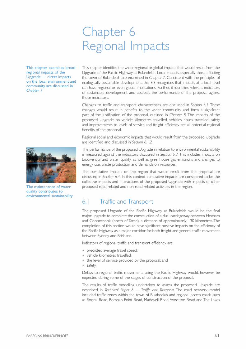
The maintenance of water quality contributes to environmental sustainability
This chapter examines broad regional impacts of the Upgrade — direct impacts on the local environment and community are discussed in Chapter 7
BULAHDELAH — UPGRADING THE PACIF IC HIGHWAY
6.2 Roads and Traffic Authority
Way. Traffic projections were made for 2004, for 2008 (a nominal opening year for the proposal) and for the future years of operation of 2018 and 2028. The actual year of opening depends on State and Commonwealth Government funding priorities for the various projects within the Pacific Highway Upgrading Program.
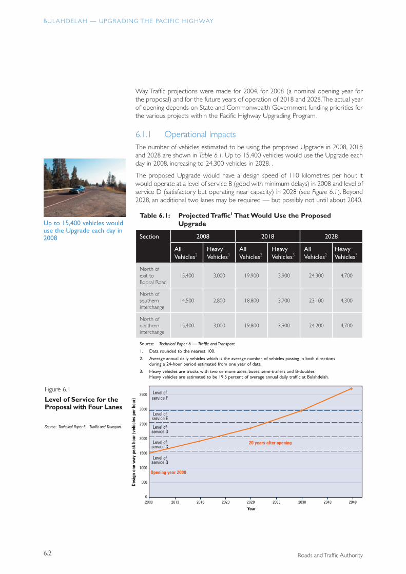
6.1.1 Operational ImpactsThe number of vehicles estimated to be using the proposed Upgrade in 2008, 2018 and 2028 are shown in Table 6.1. Up to 15,400 vehicles would use the Upgrade each day in 2008, increasing to 24,300 vehicles in 2028. .
The proposed Upgrade would have a design speed of 110 kilometres per hour. It would operate at a level of service B (good with minimum delays) in 2008 and level of service D (satisfactory but operating near capacity) in 2028 (see Figure 6.1). Beyond 2028, an additional two lanes may be required — but possibly not until about 2040.
Table 6.1: Projected Traffic1 That Would Use the Proposed Upgrade
Section 2008 2018 2028
All Vehicles2
Heavy Vehicles3
All Vehicles2
Heavy Vehicles3
All Vehicles2
Heavy Vehicles3
North of exit to Booral Road
15,400 3,000 19,900 3,900 24,300 4,700
North of southern interchange
14,500 2,800 18,800 3,700 23,100 4,300
North of northern interchange
15,400 3,000 19,800 3,900 24,200 4,700
Source: Technical Paper 6 — Traffic and Transport
1. Data rounded to the nearest 100.
2. Average annual daily vehicles which is the average number of vehicles passing in both directions during a 24-hour period estimated from one year of data.
3. Heavy vehicles are trucks with two or more axles, buses, semi-trailers and B-doubles. Heavy vehicles are estimated to be 19.5 percent of average annual daily traffic at Bulahdelah.
Up to 15,400 vehicles would use the Upgrade each day in 2008
+
Level ofservice F
Level ofservice E
Level ofservice D
Level ofservice C
Level ofservice B
Opening year 2008
+
+
+
20 years after opening
Figure 6.1
Level of Service for theProposal with Four Lanes
Des
ign
one
way
pea
k ho
ur (v
ehic
les
per h
our)
Year20080
500
1000
1500
2000
2500
3500
3000
2013 2018 2023 2028 2033 2038 2043 2048
Source: Technical Paper 6 – Traffic and Transport.
6.3
CHAPTER 6 REGIONAL IMPACTS
PARSONS BRINCKERHOFF
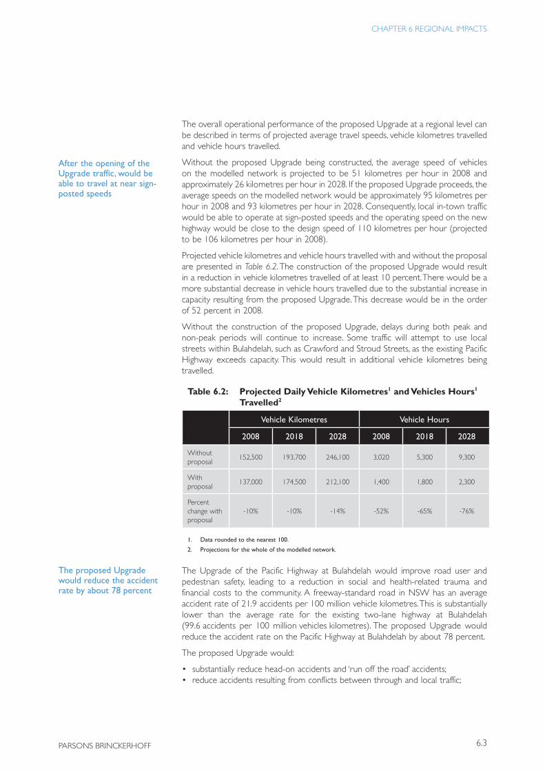
The overall operational performance of the proposed Upgrade at a regional level can be described in terms of projected average travel speeds, vehicle kilometres travelled and vehicle hours travelled.
Without the proposed Upgrade being constructed, the average speed of vehicles on the modelled network is projected to be 51 kilometres per hour in 2008 and approximately 26 kilometres per hour in 2028. If the proposed Upgrade proceeds, the average speeds on the modelled network would be approximately 95 kilometres per hour in 2008 and 93 kilometres per hour in 2028. Consequently, local in-town traffic would be able to operate at sign-posted speeds and the operating speed on the new highway would be close to the design speed of 110 kilometres per hour (projected to be 106 kilometres per hour in 2008).
Projected vehicle kilometres and vehicle hours travelled with and without the proposal are presented in Table 6.2. The construction of the proposed Upgrade would result in a reduction in vehicle kilometres travelled of at least 10 percent. There would be a more substantial decrease in vehicle hours travelled due to the substantial increase in capacity resulting from the proposed Upgrade. This decrease would be in the order of 52 percent in 2008.
Without the construction of the proposed Upgrade, delays during both peak and non-peak periods will continue to increase. Some traffic will attempt to use local streets within Bulahdelah, such as Crawford and Stroud Streets, as the existing Pacific Highway exceeds capacity. This would result in additional vehicle kilometres being travelled.
Table 6.2: Projected Daily Vehicle Kilometres1 and Vehicles Hours1
Travelled2
Vehicle Kilometres Vehicle Hours
2008 2018 2028 2008 2018 2028
Without proposal
152,500 193,700 246,100 3,020 5,300 9,300
With proposal
137,000 174,500 212,100 1,400 1,800 2,300
Percent change with proposal
-10% -10% -14% -52% -65% -76%
1. Data rounded to the nearest 100.
2. Projections for the whole of the modelled network.
The Upgrade of the Pacific Highway at Bulahdelah would improve road user and pedestrian safety, leading to a reduction in social and health-related trauma and financial costs to the community. A freeway-standard road in NSW has an average accident rate of 21.9 accidents per 100 million vehicle kilometres. This is substantially lower than the average rate for the existing two-lane highway at Bulahdelah (99.6 accidents per 100 million vehicles kilometres). The proposed Upgrade would reduce the accident rate on the Pacific Highway at Bulahdelah by about 78 percent.
The proposed Upgrade would:
• substantially reduce head-on accidents and ‘run off the road’ accidents;• reduce accidents resulting from conflicts between through and local traffic;
After the opening of the Upgrade traffic, would be able to travel at near sign-posted speeds
The proposed Upgrade would reduce the accident rate by about 78 percent
BULAHDELAH — UPGRADING THE PACIF IC HIGHWAY
6.4 Roads and Traffic Authority
• reduce the number of traffic accidents causing fatalities and serious injuries; and• reduce accidents resulting from conflicts between through traffic, pedestrians and
cyclists.
6.1.2 Impacts During ConstructionThe construction staging and traffic management requirements are outlined in Technical Paper 4 — The Proposal and Technical Paper 6 — Traffic and Transport.
A maximum of 300 truck movements would be generated by the construction of the Upgrade. While appropriate local traffic management is required to reduce the impacts of truck movements on the operation of local roads and the amenity of local residents, the total number of truck movements is a small proportion of the approximately 12,000 vehicles, including over 2,000 heavy vehicles, that use the Pacific Highway each day.
Most of the proposed Upgrade would be located and constructed well away from the existing highway. There would be potential for delays to regional traffic during construction where the proposed Upgrade connects to the existing highway south of Booral Road and north of Lee Street.
Figure 5.23 shows the traffic arrangements at the northern end of the proposal, which allows for minimal disturbance to traffic flow during these stages. During construction, the speed limit of the existing highway would be reduced to between 40 and 60 kilometres per hour at the northern and southern ends of the proposal, essentially expanding the current 60 kilometre per hour zone by 2 kilometres in both the southerly and northerly direction. These speed limits would depend on the adjacent construction activities.
The contractor would be required to establish traffic management measures to ensure safe and efficient movement of local and highway traffic during construction.
6.2 Social and Economic Impacts
6.2.1 Potential Regional ImpactsSocial impacts are commonly considered to comprise changes to people’s way of life, culture, traditions, community structure, cohesion or stability. Broadly speaking, social impacts may be categorised as quantifiable, such as the likely effects on future population growth, or unquantifiable, such as the likely effects on community wellbeing, social character and access to opportunities or amenities.
Construction and operation of the proposed Upgrade would be expected to have social and economic impacts not only on people living within Bulahdelah and its surrounding areas (refer Sections 7.3.4 and 7.4.4), but also on people living in the broader region, and even New South Wales and Australia as a whole. Some of the social impacts would relate to the cumulative impacts of the proposal as described in Section 6.4.
Section 3.2 of this EIS identifies community values expressed during the consultation activities undertaken as part of the development of the proposed Upgrade. The proposal could potentially impact on these values, both regionally and locally. The values which are important to the communities consulted relate to:
• access;
Construction of the Upgrade would result in up to 300 additional truck movements on the existing highway
6.5
CHAPTER 6 REGIONAL IMPACTS
PARSONS BRINCKERHOFF
• amenity;• natural and cultural heritage; and• economic sustainability.
6.2.2 AccessibilityIn regional terms, the proposed Upgrade, in conjunction with other projects associated with the Pacific Highway Upgrading Program, would substantially improve accessibility. It would be cheaper and easier to access regional centres such as Forster and Taree from the south, and Port Stephens, Raymond Terrace and Newcastle from the north.
The population of coastal New South Wales is expected to grow at a faster rate than the rest of New South Wales over the next 40 years (Department of Infrastructure, Planning and Natural Resources 2004). In the 20-year period 1981–2001 the Mid North Coast region to the north of Bulahdelah, which includes the major centres of Taree, Port Macquarie, Kempsey, Coffs Harbour and Grafton, experienced substantial growth of 2.3 percent per year. Over the next 30 years this rate of growth is expected to slow but is still expected to be 1.1 percent per year up until 2006 and 0.7 percent per year thereafter. The Mid North Coast region is expected to have the biggest growth from internal migration of any region in New South Wales (Department of Infrastructure, Planning and Natural Resources 2004).
The proposed Upgrade at Bulahdelah, and other projects on the Pacific Highway, would both encourage and support this level of growth. Substantial increases in regional population in New South Wales can result in both benefits and adverse impacts on the local community such as:
• economic growth and related opportunities;• changes in employment rates and economic structures;• increases in government and private-sector services;• increases in the variety of cultural and recreational opportunities and activities; • both the potential for stress on the capacity of transport and other urban
infrastructure facilities and, over time, potential improvements to those facilities; • potential adverse impacts on the natural environment due to urban
development;• changes in land use and land values; and• increased demands on State and local government land use and infrastructure
planning resources.
Most of the growth in population in coastal New South Wales is expected in the older age groups as retirees migrate from Sydney and hinterland New South Wales. The median age is expected to increase from just over 40 years to over 50 years in coastal New South Wales between 2001 and 2031 (Department of Infrastructure, Planning and Natural Resources 2004).
Due to the extent and nature of this population increase a range of regional social and biophysical issues will need to be addressed. While the proposed Upgrade is, in part, intended to support this growth, the regional planning issues that arise are matters for ongoing strategic planning by relevant State and local government authorities. An example of this strategic planning is the recently updated (12 March 2004) State Environmental Planning Policy No. 71 — Coastal Protection. This policy aims to ensure that development in the New South Wales coastal zone is appropriate and suitably located, and to apply a consistent and strategic approach to coastal planning, assessment and management.
The Upgrade and other projects on the Pacific Highway would both encourage and support population growth within the northern coastal regions of NSW
Regional population growth is an ongoing strategic planning issue being addressed by relevant State and local government agencies
BULAHDELAH — UPGRADING THE PACIF IC HIGHWAY
6.6 Roads and Traffic Authority
The improved accessibility arising from the implementation of proposals such as the Upgrade of the Pacific Highway at Bulahdelah would provide a large cross-section of society with an improved range of choices in housing, work, culture and leisure. A large number of people are making the choice to relocate to the coastal regions of New South Wales for a variety of economic and lifestyle reasons. Improved transport infrastructure is required to ensure that the increasing population can be appropriately accommodated with minimal impacts on existing local communities and the biophysical environment.
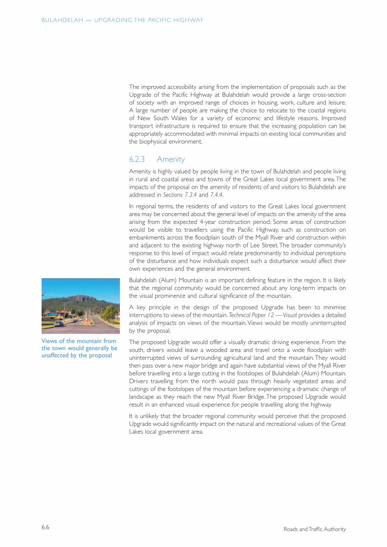
6.2.3 AmenityAmenity is highly valued by people living in the town of Bulahdelah and people living in rural and coastal areas and towns of the Great Lakes local government area. The impacts of the proposal on the amenity of residents of and visitors to Bulahdelah are addressed in Sections 7.3.4 and 7.4.4.
In regional terms, the residents of and visitors to the Great Lakes local government area may be concerned about the general level of impacts on the amenity of the area arising from the expected 4-year construction period. Some areas of construction would be visible to travellers using the Pacific Highway, such as construction on embankments across the floodplain south of the Myall River and construction within and adjacent to the existing highway north of Lee Street. The broader community’s response to this level of impact would relate predominantly to individual perceptions of the disturbance and how individuals expect such a disturbance would affect their own experiences and the general environment.
Bulahdelah (Alum) Mountain is an important defining feature in the region. It is likely that the regional community would be concerned about any long-term impacts on the visual prominence and cultural significance of the mountain.
A key principle in the design of the proposed Upgrade has been to minimise interruptions to views of the mountain. Technical Paper 12 — Visual provides a detailed analysis of impacts on views of the mountain. Views would be mostly uninterrupted by the proposal.
The proposed Upgrade would offer a visually dramatic driving experience. From the south, drivers would leave a wooded area and travel onto a wide floodplain with uninterrupted views of surrounding agricultural land and the mountain. They would then pass over a new major bridge and again have substantial views of the Myall River before travelling into a large cutting in the footslopes of Bulahdelah (Alum) Mountain. Drivers travelling from the north would pass through heavily vegetated areas and cuttings of the footslopes of the mountain before experiencing a dramatic change of landscape as they reach the new Myall River Bridge. The proposed Upgrade would result in an enhanced visual experience for people travelling along the highway.
It is unlikely that the broader regional community would perceive that the proposed Upgrade would significantly impact on the natural and recreational values of the Great Lakes local government area.
Views of the mountain from the town would generally be unaffected by the proposal
6.7
CHAPTER 6 REGIONAL IMPACTS
PARSONS BRINCKERHOFF
6.2.4 Natural and Cultural HeritageApproximately one-third of the Great Lakes local government area consists of National Parks and State Forests, with the remaining area incorporating a triple lake system, numerous rivers and beaches. The potential regional and ecological impacts of the proposed Upgrade on the natural heritage of the region are addressed in detail in Technical Paper 7 — Ecological Assessment and Species Impact Statement. A summary of this assessment is contained in Section 6.3.
The cultural environment of the region includes features of non-Indigenous and Indigenous heritage. Technical Paper 16 — Heritage provides a detailed assessment of the impacts of the proposed Upgrade on these features. Impacts on heritage features within and surrounding Bulahdelah are summarised in Section 7.23.
Visibly, historically and spiritually, the town of Bulahdelah and the region have a connection with Bulahdelah (Alum) Mountain. The recreational areas associated with the mountain are regularly used by schools and individuals and are highly valued by the local and broader community.
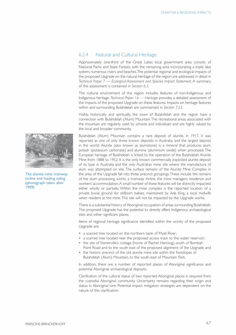
Bulahdelah (Alum) Mountain contains a rare deposit of alunite. In 1917, it was reported as one of only three known deposits in Australia, and the largest deposit in the world. Alunite (also known as alumstone) is a mineral that produces alum, potash (potassium carbonate) and alumina (aluminium oxide) when processed. The European heritage of Bulahdelah is linked to the operation of the Bulahdelah Alunite Mine from 1888 to 1952. It is the only known commercially exploited alunite deposit of its type in Australia and the only Australian mine site where the manufacture of alum was attempted on site. The surface remains of the Alunite Mine Complex in the area of the Upgrade fall into three precinct groupings. These include the remains of the alum processing works, a tramway incline, the mine managers residence and workers’ accommodation. A small number of these features will be distinctly impacted, either wholly or partially. Within the mine complex is the reported location of a private burial ground for stillborn babies, maintained by Ada King, a local midwife when resident at the mine. This site will not be impacted by the Upgrade works.
There is a substantial history of Aboriginal occupation of areas surrounding Bulahdelah. The proposed Upgrade has the potential to directly affect Indigenous archaeological sites and other significant places.
Items of regional heritage significance identified within the vicinity of the proposed Upgrade are:
• a scarred tree located on the northern bank of Myall River ;• a scarred tree located near the proposed access track to the water reservoir ;• the site of Somerville’s cottage (home of Rachel Henning), south of Bombah
Point Road and to the south-east of the proposed alignment of the Upgrade; and• the historic precinct of the old alunite mine site within the footslopes of
Bulahdelah (Alum) Mountain, to the south-east of Mountain Park.
In addition, there are a number of reported places of Aboriginal significance and potential Aboriginal archaeological deposits.
Clarification of the cultural status of two reported Aboriginal places is required from the custodial Aboriginal community. Uncertainty remains regarding their origin and status in Aboriginal lore. Potential impact mitigation strategies are dependent on the nature of this clarification.
The alunite mine tramway incline and loading siding (photograph taken after 1909)
BULAHDELAH — UPGRADING THE PACIF IC HIGHWAY
6.8 Roads and Traffic Authority
The route alignment and concept design has been developed to avoid or mitigate impacts on items of regional heritage significance. The scarred trees and the site of Somerville’s cottage would be retained and opportunities to enhance their heritage and social significance would be undertaken. The historic mining precinct would be crossed by the proposed Upgrade. Adjustments to the route alignment and a number of measures such as improvements to Mountain Park, interpretive signage and the steel truss Mountain Access Overbridge would mitigate impacts and assist in reinforcing the heritage significance of the precinct.
A summary of proposed environmental management measures is provided in Appendix F.
6.2.5 Regional Economic BenefitsAs discussed in Section 3.1.2, there have been significant structural changes in the economy of Bulahdelah over the last 50 years. The impacts of the proposed Upgrade on the local economy are discussed in detail in Section 7.2.4. The broader quantifiable economic benefits of the proposed Upgrade are outlined in Section 6.4 below.
Many economic, environmental and social impacts cannot be quantified in monetary terms. These impacts can include both beneficial and adverse effects of the proposal.
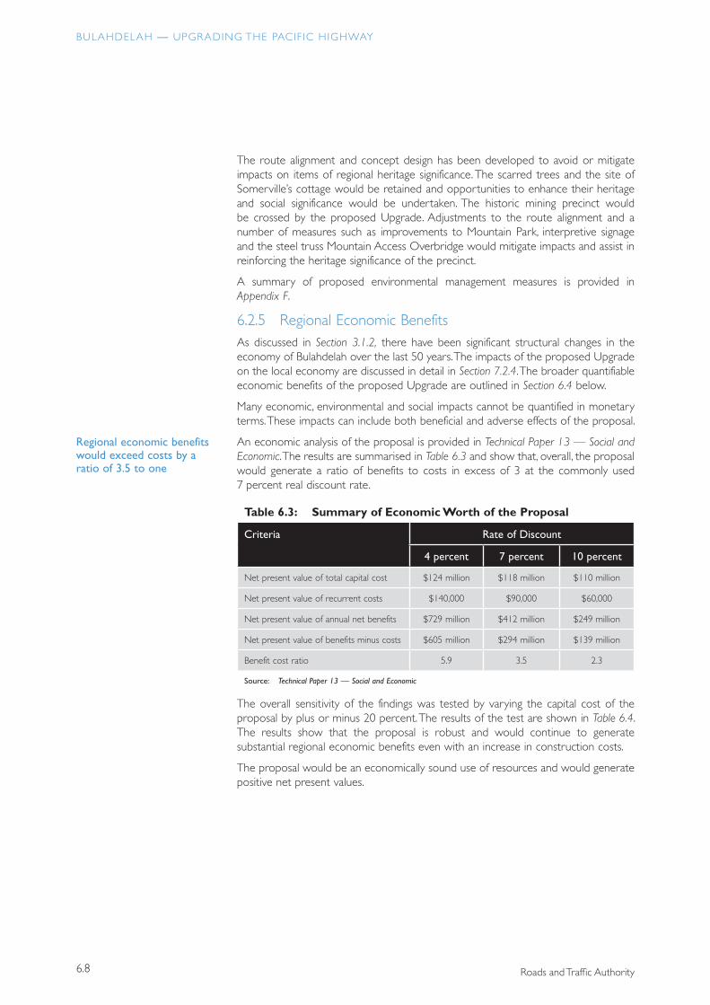
An economic analysis of the proposal is provided in Technical Paper 13 — Social and Economic. The results are summarised in Table 6.3 and show that, overall, the proposal would generate a ratio of benefits to costs in excess of 3 at the commonly used 7 percent real discount rate.
Table 6.3: Summary of Economic Worth of the Proposal
Criteria Rate of Discount
4 percent 7 percent 10 percent
Net present value of total capital cost $124 million $118 million $110 million
Net present value of recurrent costs $140,000 $90,000 $60,000
Net present value of annual net benefits $729 million $412 million $249 million
Net present value of benefits minus costs $605 million $294 million $139 million
Benefit cost ratio 5.9 3.5 2.3
Source: Technical Paper 13 — Social and Economic
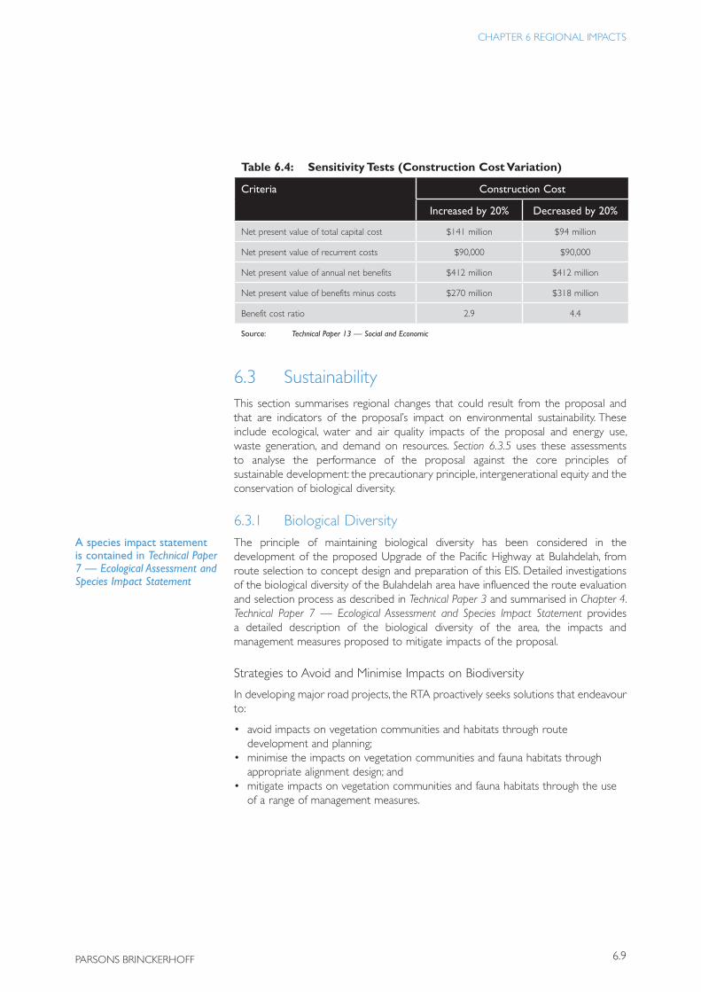
The overall sensitivity of the findings was tested by varying the capital cost of the proposal by plus or minus 20 percent. The results of the test are shown in Table 6.4. The results show that the proposal is robust and would continue to generate substantial regional economic benefits even with an increase in construction costs.
The proposal would be an economically sound use of resources and would generate positive net present values.
Regional economic benefits would exceed costs by a ratio of 3.5 to one
6.9
CHAPTER 6 REGIONAL IMPACTS
PARSONS BRINCKERHOFF
Table 6.4: Sensitivity Tests (Construction Cost Variation)
Criteria Construction Cost
Increased by 20% Decreased by 20%
Net present value of total capital cost $141 million $94 million
Net present value of recurrent costs $90,000 $90,000
Net present value of annual net benefits $412 million $412 million
Net present value of benefits minus costs $270 million $318 million
Benefit cost ratio 2.9 4.4
Source: Technical Paper 13 — Social and Economic
6.3 SustainabilityThis section summarises regional changes that could result from the proposal and that are indicators of the proposal’s impact on environmental sustainability. These include ecological, water and air quality impacts of the proposal and energy use, waste generation, and demand on resources. Section 6.3.5 uses these assessments to analyse the performance of the proposal against the core principles of sustainable development: the precautionary principle, intergenerational equity and the conservation of biological diversity.
6.3.1 Biological DiversityThe principle of maintaining biological diversity has been considered in the development of the proposed Upgrade of the Pacific Highway at Bulahdelah, from route selection to concept design and preparation of this EIS. Detailed investigations of the biological diversity of the Bulahdelah area have influenced the route evaluation and selection process as described in Technical Paper 3 and summarised in Chapter 4. Technical Paper 7 — Ecological Assessment and Species Impact Statement provides a detailed description of the biological diversity of the area, the impacts and management measures proposed to mitigate impacts of the proposal.
Strategies to Avoid and Minimise Impacts on Biodiversity
In developing major road projects, the RTA proactively seeks solutions that endeavour to:
• avoid impacts on vegetation communities and habitats through route development and planning;
• minimise the impacts on vegetation communities and fauna habitats through appropriate alignment design; and
• mitigate impacts on vegetation communities and fauna habitats through the use of a range of management measures.
A species impact statement is contained in Technical Paper 7 — Ecological Assessment and Species Impact Statement
BULAHDELAH — UPGRADING THE PACIF IC HIGHWAY
6.10 Roads and Traffic Authority
The route selection process and outcomes described in Chapter 4 resulted in avoidance of the following major potential impacts on biodiversity:
• creation of an additional physical barrier across two identified regional fauna corridors;
• a new crossing over Frys Creek; and• a major crossing over Crawford River.
In addition, the outcomes of the route selection process minimise the following major potential impacts on biodiversity:
• vegetation and habitat loss;• habitat fragmentation and edge effects; and• barrier impacts.
Once Option E was selected, knowledge of the existing environment within and surrounding the corridor was supplemented by more intense investigations which informed a more detailed design refinement process to further reduce the biological impacts. These design refinements included:
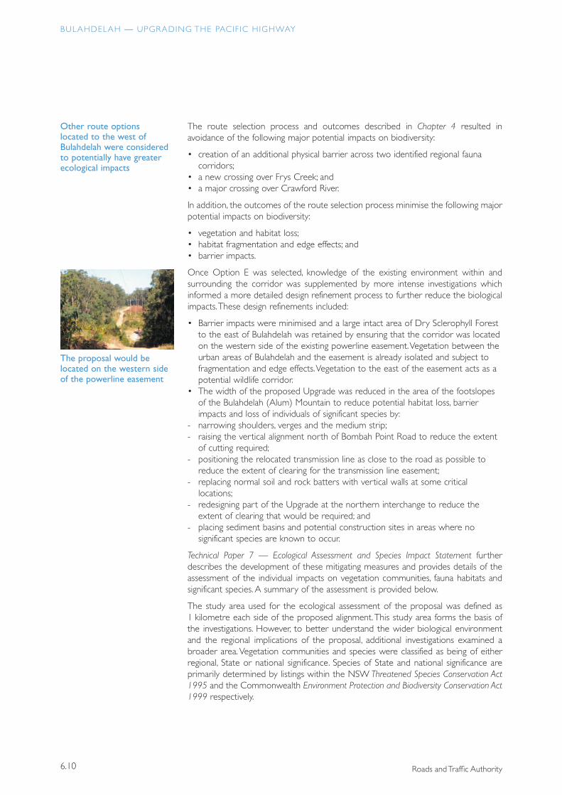
• Barrier impacts were minimised and a large intact area of Dry Sclerophyll Forest to the east of Bulahdelah was retained by ensuring that the corridor was located on the western side of the existing powerline easement. Vegetation between the urban areas of Bulahdelah and the easement is already isolated and subject to fragmentation and edge effects. Vegetation to the east of the easement acts as a potential wildlife corridor.
• The width of the proposed Upgrade was reduced in the area of the footslopes of the Bulahdelah (Alum) Mountain to reduce potential habitat loss, barrier impacts and loss of individuals of significant species by:
- narrowing shoulders, verges and the medium strip;- raising the vertical alignment north of Bombah Point Road to reduce the extent
of cutting required;- positioning the relocated transmission line as close to the road as possible to
reduce the extent of clearing for the transmission line easement;- replacing normal soil and rock batters with vertical walls at some critical
locations; - redesigning part of the Upgrade at the northern interchange to reduce the
extent of clearing that would be required; and- placing sediment basins and potential construction sites in areas where no
significant species are known to occur.
Technical Paper 7 — Ecological Assessment and Species Impact Statement further describes the development of these mitigating measures and provides details of the assessment of the individual impacts on vegetation communities, fauna habitats and significant species. A summary of the assessment is provided below.
The study area used for the ecological assessment of the proposal was defined as 1 kilometre each side of the proposed alignment. This study area forms the basis of the investigations. However, to better understand the wider biological environment and the regional implications of the proposal, additional investigations examined a broader area. Vegetation communities and species were classified as being of either regional, State or national significance. Species of State and national significance are primarily determined by listings within the NSW Threatened Species Conservation Act 1995 and the Commonwealth Environment Protection and Biodiversity Conservation Act 1999 respectively.
The proposal would be located on the western side of the powerline easement
Other route options located to the west of Bulahdelah were considered to potentially have greater ecological impacts
6.11
CHAPTER 6 REGIONAL IMPACTS
PARSONS BRINCKERHOFF
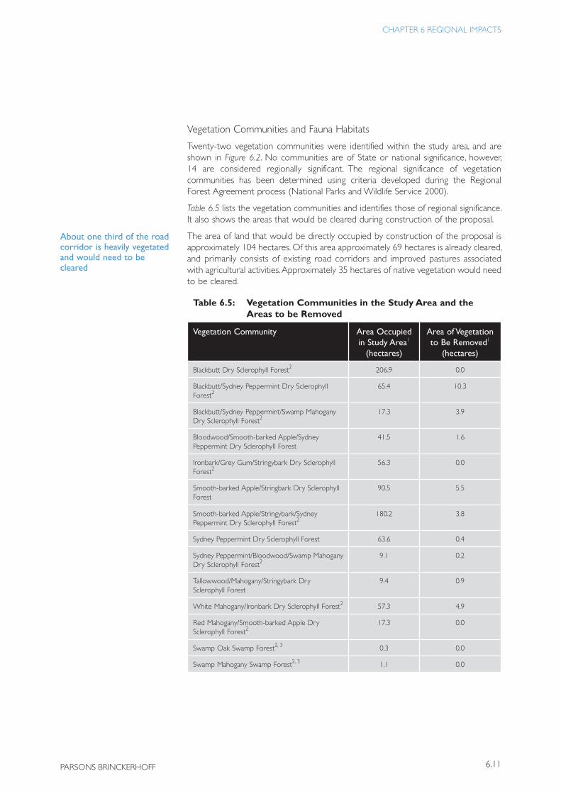
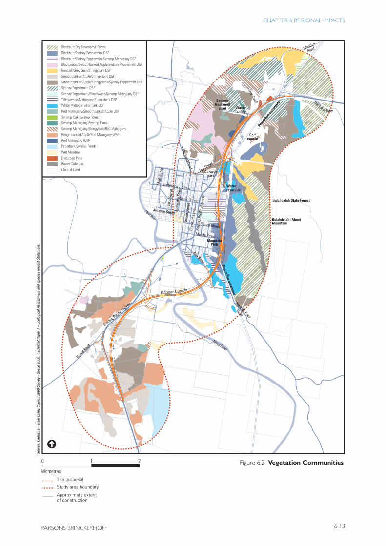
Vegetation Communities and Fauna Habitats
Twenty-two vegetation communities were identified within the study area, and are shown in Figure 6.2. No communities are of State or national significance, however, 14 are considered regionally significant. The regional significance of vegetation communities has been determined using criteria developed during the Regional Forest Agreement process (National Parks and Wildlife Service 2000).
Table 6.5 lists the vegetation communities and identifies those of regional significance. It also shows the areas that would be cleared during construction of the proposal.
The area of land that would be directly occupied by construction of the proposal is approximately 104 hectares. Of this area approximately 69 hectares is already cleared, and primarily consists of existing road corridors and improved pastures associated with agricultural activities. Approximately 35 hectares of native vegetation would need to be cleared.
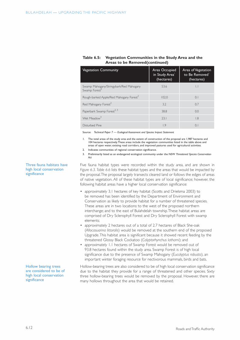
Table 6.5: Vegetation Communities in the Study Area and the Areas to be Removed
Vegetation Community Area Occupied in Study Area1
(hectares)
Area of Vegetation to Be Removed1
(hectares)
Blackbutt Dry Sclerophyll Forest2 206.9 0.0
Blackbutt/Sydney Peppermint Dry Sclerophyll Forest2
65.4 10.3
Blackbutt/Sydney Peppermint/Swamp Mahogany Dry Sclerophyll Forest2
17.3 3.9
Bloodwood/Smooth-barked Apple/Sydney Peppermint Dry Sclerophyll Forest
41.5 1.6
Ironbark/Grey Gum/Stringybark Dry Sclerophyll Forest2
56.3 0.0
Smooth-barked Apple/Stringbark Dry Sclerophyll Forest
90.5 5.5
Smooth-barked Apple/Stringybark/Sydney Peppermint Dry Sclerophyll Forest2
180.2 3.8
Sydney Peppermint Dry Sclerophyll Forest 63.6 0.4
Sydney Peppermint/Bloodwood/Swamp Mahogany Dry Sclerophyll Forest2
9.1 0.2
Tallowwood/Mahogany/Stringybark Dry Sclerophyll Forest
9.4 0.9
White Mahogany/Ironbark Dry Sclerophyll Forest2 57.3 4.9
Red Mahogany/Smooth-barked Apple Dry Sclerophyll Forest2
17.3 0.0
Swamp Oak Swamp Forest2, 3 0.3 0.0
Swamp Mahogany Swamp Forest2, 3 1.1 0.0
About one third of the road corridor is heavily vegetated and would need to be cleared
BULAHDELAH — UPGRADING THE PACIF IC HIGHWAY
6.12 Roads and Traffic Authority
Table 6.5: Vegetation Communities in the Study Area and the Areas to be Removed
Vegetation Community Area Occupied in Study Area1
(hectares)
Area of Vegetation to Be Removed1
(hectares)
Swamp Mahogany/Stringybark/Red Mahogany Swamp Forest2
53.6 1.1
Rough-barked Apple/Red Mahogany Forest2 102.0 0.1
Red Mahogany Forest2 3.2 0.7
Paperbark Swamp Forest2, 3 38.8 0.0
Wet Meadow3 23.1 1.8
Disturbed Pine 1.9 0.1
Source: Technical Paper 7 — Ecological Assessment and Species Impact Statement
1. The total areas of the study area and the extent of construction of the proposal are 1,987 hectares and 104 hectares respectively. These areas include the vegetation communities listed in the table above and areas of open water, existing road corridors, and improved pastures used for agricultural activities.
2. Indicates communities of regional conservation significance.
3. Preliminarily listed as an endangered ecological community under the NSW Threatened Species Conservation Act
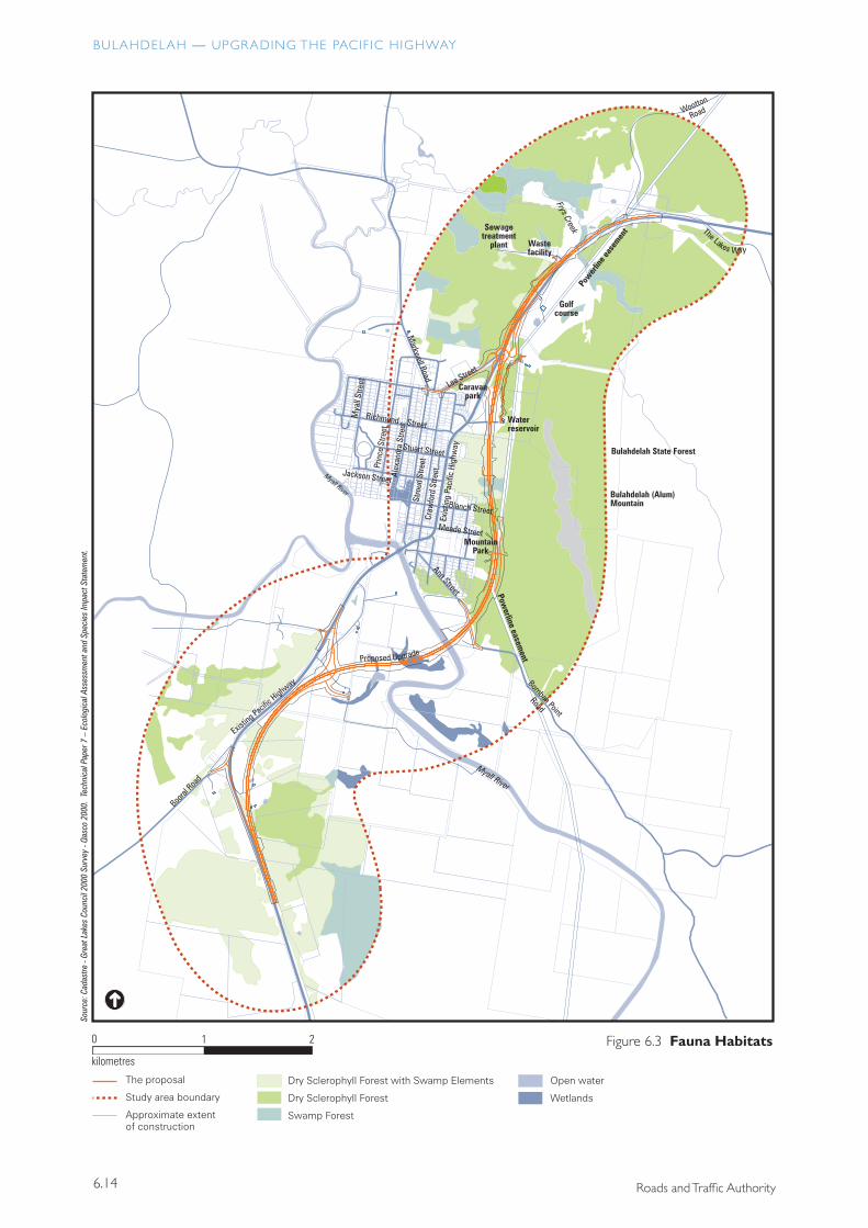
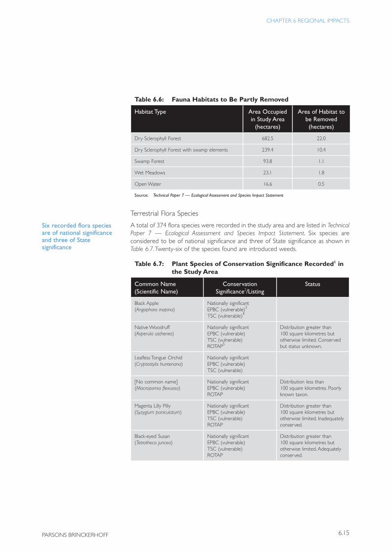
Five fauna habitat types were recorded within the study area, and are shown in Figure 6.3. Table 6.6 lists these habitat types and the areas that would be impacted by the proposal. The proposal largely transects cleared land or follows the edges of areas of native vegetation. All of these habitat types are of local significance; however, the following habitat areas have a higher local conservation significance:
• approximately 3.1 hectares of key habitat (Scotts and Drielsma 2003) to be removed has been identified by the Department of Environment and Conservation as likely to provide habitat for a number of threatened species. These areas are in two locations: to the west of the proposed northern interchange; and to the east of Bulahdelah township. These habitat areas are comprised of Dry Sclerophyll Forest and Dry Sclerophyll Forest with swamp elements;
• approximately 2 hectares out of a total of 2.7 hectares of Black She-oak (Allocasuarina littoralis) would be removed at the southern end of the proposed Upgrade. This habitat area is significant because it showed recent feeding by the threatened Glossy Black Cockatoo (Calyptorhynchus lathami); and
• approximately 1.1 hectares of Swamp Forest would be removed out of 93.8 hectares found within the study area. Swamp Forest is of high local significance due to the presence of Swamp Mahogany (Eucalyptus robusta), an important winter foraging resource for nectivorous mammals, birds and bats.
Hollow-bearing trees are also considered to be of high local conservation significance due to the habitat they provide for a range of threatened and other species. Sixty three hollow-bearing trees would be removed by the proposal. However, there are many hollows throughout the area that would be retained.
(continued)
Hollow bearing trees are considered to be of high local conservation significance
Three fauna habitats have high local conservation significance
6.13
CHAPTER 6 REGIONAL IMPACTS
PARSONS BRINCKERHOFF
������������
�������������������
���������������������������������
����
�����
����
������
����
�����
����
����
�����
����
����
�����
����
����
�����
����
����
����
����
����
����
����
�����
����
�����
����
����
�����
����
����
���
�����
� �
����������
�
��������������������
����������
����������������
����� �������������
��������
����
����������
���
�����
�����
����
�
��������������
����������
������������������
�������������
����
����
�����
����
����
�����
����
�����
����
�����
����
����
�����
��������
�����������
����
����
�����
����
����
����
����
���
�����
����
�������������
���������������������
����
����������
�������������
����
�����������
���������������
���
�����������
��������������
������
�����
�������
��������
�������
��
�����������������������
�����������������
���������������������������
��������������
����������������������������������
��������������������������������
�������������������������������
����������������������������������������������
��������������������������������������������������
���������������������������������
����������������������������������
����������������������������������������������������
���������������������
����������������������������������������������
�����������������������������������
���������������������������
�����������������������������������
����������������������
���������������������������
���������������������������������������
�����������������������������������
����������������
����������������������
����������
��������������
��������������
������������
BULAHDELAH — UPGRADING THE PACIF IC HIGHWAY
6.14 Roads and Traffic Authority
������������
�������������������
���������������������������������
����
�����
����
������
����
�����
����
����
�����
����
����
�����
����
����
�����
����
����
����
����
����
����
����
�����
����
�����
����
����
�����
����
����
���
����
� �
����������
�
��������������������
����������
����������������
����� �������������
��������
����
����������
���
�����
�����
����
�
��������������
����������
������������������
�������������
����
����
�����
����
����
�����
����
�����
����
�����
����
����
�����
��������
�����������
����
����
�����
����
����
����
����
���
�����
����
�������������
���������������������
����
����������
�������������
����
�����������
���������������
���
�����������
��������������
������
�����
�������
��������
�������
��
�����������������������
�����������������
���������������������������
����������
��������
��������������
��������������������������
������������������������������������������
����������������������
������������
6.15
CHAPTER 6 REGIONAL IMPACTS
PARSONS BRINCKERHOFF
Table 6.6: Fauna Habitats to Be Partly Removed
Habitat Type Area Occupied in Study Area
(hectares)
Area of Habitat to be Removed(hectares)
Dry Sclerophyll Forest 682.5 22.0
Dry Sclerophyll Forest with swamp elements 239.4 10.4
Swamp Forest 93.8 1.1
Wet Meadows 23.1 1.8
Open Water 16.6 0.5
Source: Technical Paper 7 — Ecological Assessment and Species Impact Statement
Terrestrial Flora Species
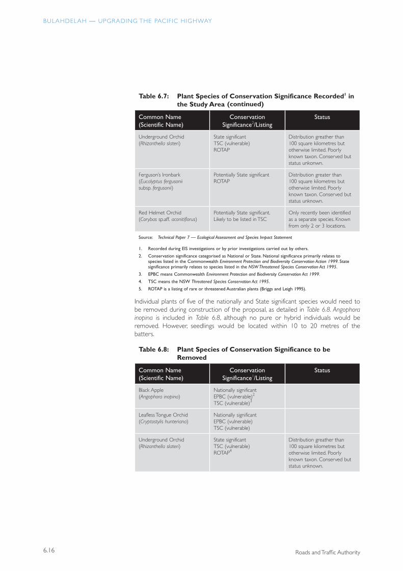
A total of 374 flora species were recorded in the study area and are listed in Technical Paper 7 — Ecological Assessment and Species Impact Statement. Six species are considered to be of national significance and three of State significance as shown in Table 6.7. Twenty-six of the species found are introduced weeds.
Table 6.7: Plant Species of Conservation Significance Recorded1 in the Study Area
Common Name (Scientific Name)
Conservation Significance2/Listing
Status
Black Apple (Angophora inopina)
Nationally significant EPBC (vulnerable)3
TSC (vulnerable)4
Native Woodruff (Asperula asthenes)
Nationally significant EPBC (vulnerable) TSC (vulnerable) ROTAP5
Distribution greater than 100 square kilometres but otherwise limited. Conserved but status unknown.
Leafless Tongue Orchid (Cryptostylis hunteriana)
Nationally significant EPBC (vulnerable) TSC (vulnerable)
[No common name] (Macrozamia flexuosa)
Nationally significant EPBC (vulnerable) ROTAP
Distribution less than 100 square kilometres. Poorly known taxon.
Magenta Lilly Pilly (Syzygium paniculatum)
Nationally significant EPBC (vulnerable) TSC (vulnerable) ROTAP
Distribution greater than 100 square kilometres but otherwise limited. Inadequately conserved.
Black-eyed Susan (Tetratheca juncea)
Nationally significant EPBC (vulnerable) TSC (vulnerable) ROTAP
Distribution greater than 100 square kilometres but otherwise limited. Adequately conserved.
Six recorded flora species are of national significance and three of State significance
BULAHDELAH — UPGRADING THE PACIF IC HIGHWAY
6.16 Roads and Traffic Authority
Table 6.7: Plant Species of Conservation Significance Recorded1 in the Study Area
Common Name (Scientific Name)
Conservation Significance2/Listing
Status
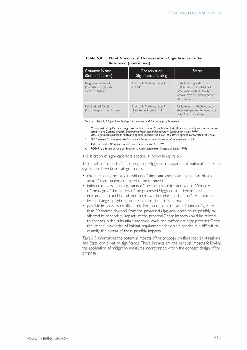
Underground Orchid (Rhizanthella slateri)
State significant TSC (vulnerable) ROTAP
Distribution greather than 100 square kilometres but otherwise limited. Poorly known taxon. Conserved but status unkonwn.
Ferguson’s Ironbark (Eucalyptus fergusonii subsp. fergusonii)
Potentially State significant ROTAP
Distribution greater than 100 square kilometres but otherwise limited. Poorly known taxon. Conserved but status unknown.
Red Helmet Orchid (Corybas sp.aff. aconitiflorus)
Potentially State significant. Likely to be listed in TSC
Only recently been identified as a separate species. Known from only 2 or 3 locations.
Source: Technical Paper 7 — Ecological Assessment and Species Impact Statement
1. Recorded during EIS investigations or by prior investigations carried out by others.
2. Conservation significance categorised as National or State. National significance primarily relates to species listed in the Commonwealth Environment Protection and Biodiversity Conservation Action 1999. State significance primarily relates to species listed in the NSW Threatened Species Conservation Act 1995.
3. EPBC means Commonwealth Environment Protection and Biodiversity Conservation Act 1999.
4. TSC means the NSW Threatened Species Conservation Act 1995.
5. ROTAP is a listing of rare or threatened Australian plants (Briggs and Leigh 1995).
Individual plants of five of the nationally and State significant species would need to be removed during construction of the proposal, as detailed in Table 6.8. Angophora inopina is included in Table 6.8, although no pure or hybrid individuals would be removed. However, seedlings would be located within 10 to 20 metres of the batters.
Table 6.8: Plant Species of Conservation Significance to be Removed
Common Name (Scientific Name)
Conservation Significance1/Listing
Status
Black Apple (Angophora inopina)
Nationally significant EPBC (vulnerable)2
TSC (vulnerable)3
Leafless Tongue Orchid (Cryptostylis hunteriana)
Nationally significant EPBC (vulnerable) TSC (vulnerable)
Underground Orchid (Rhizanthella slateri)
State significant TSC (vulnerable) ROTAP4
Distribution greather than 100 square kilometres but otherwise limited. Poorly known taxon. Conserved but status unknown.
(continued)
6.17
CHAPTER 6 REGIONAL IMPACTS
PARSONS BRINCKERHOFF
Table 6.8: Plant Species of Conservation Significance to be Removed
Common Name (Scientific Name)
Conservation Significance1/Listing
Status
Ferguson’s Ironbark (Eucalyptus fergusonii subsp. fergusonii)
Potentially State significant ROTAP
Distribution greater than 100 square kilometres but otherwise limited. Poorly known taxon. Conserved but status unknown.
Red Helmet Orchid (Corybas sp.aff aconitiflorus)
Potentially State significant. Likely to be listed in TSC.
Only recently identified as a separate species. Known from only 2 or 3 locations..
Source: Technical Paper 7 — Ecological Assessment and Species Impact Statement
1. Conservation significance categorised as National or State. National significance primarily relates to species listed in the Commonwealth Environment Protection and Biodiversity Conservation Action 1999. State significance primarily relates to species listed in the NSW Threatened Species Conservation Act 1995.
2. EPBC means Commonwealth Environment Protection and Biodiversity Conservation Act 1999.
3. TSC means the NSW Threatened Species Conservation Act 1995.
4. ROTAP is a listing of rare or threatened Australian plants (Briggs and Leigh 1995).
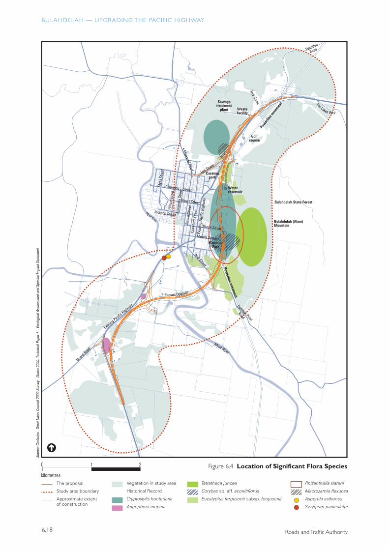
The location of significant flora species is shown in Figure 6.4.
The levels of impact of the proposed Upgrade on species of national and State significance have been categorised as:
• direct impacts, meaning individuals of the plant species are located within the area of construction and need to be removed;
• indirect impacts, meaning plants of the species are located within 20 metres of the edge of the batters of the proposed Upgrade and their immediate environment could be subject to changes in surface and subsurface moisture levels, changes in light exposure, and localised habitat loss; and
• possible impacts, especially in relation to orchid plants at a distance of greater than 20 metres downhill from the proposed Upgrade, which could possibly be affected by secondary impacts of the proposal. These impacts could be related to changes in the subsurface moisture levels and surface drainage patterns. Given the limited knowledge of habitat requirements for orchid species, it is difficult to quantify the extent of these possible impacts.
Table 6.9 summarises the potential impacts of the proposal on flora species of national and State conservation significance. These impacts are the residual impacts following the application of mitigation measures incorporated within the concept design of the proposal.
(continued)
BULAHDELAH — UPGRADING THE PACIF IC HIGHWAY
6.18 Roads and Traffic Authority
������������
�������������������
���������������������������������
����
�����
����
������
����
�����
����
����
�����
����
����
�����
����
����
����
����
����
����
����
����
����
����
�����
����
�����
����
����
�����
����
����
���
�����
�
������������������������
�����������������
�����������������������
�����������������
� �
����������
� �������������������������������������������������
��������������������
�����������������
������������������������������
���������������������������������������
���������������������
�������������������
�����������������
��������������������
����������
����������������
����� �������������
��������
����
����������
���
�����
�����
����
�
��������������
����������
������������������
�������������
����
����
�����
����
����
�����
����
�����
����
�����
����
����
�����
��������
�����������
����
����
�����
����
����
����
����
���
�����
����
�������������
���������������������
����
����������
�������������
����
�����������
���������������
���
�����������
��������������
������
�����
�������
��������
�������
��
�����������������������
�����������������
���������������������������
��������������
6.19
CHAPTER 6 REGIONAL IMPACTS
PARSONS BRINCKERHOFF
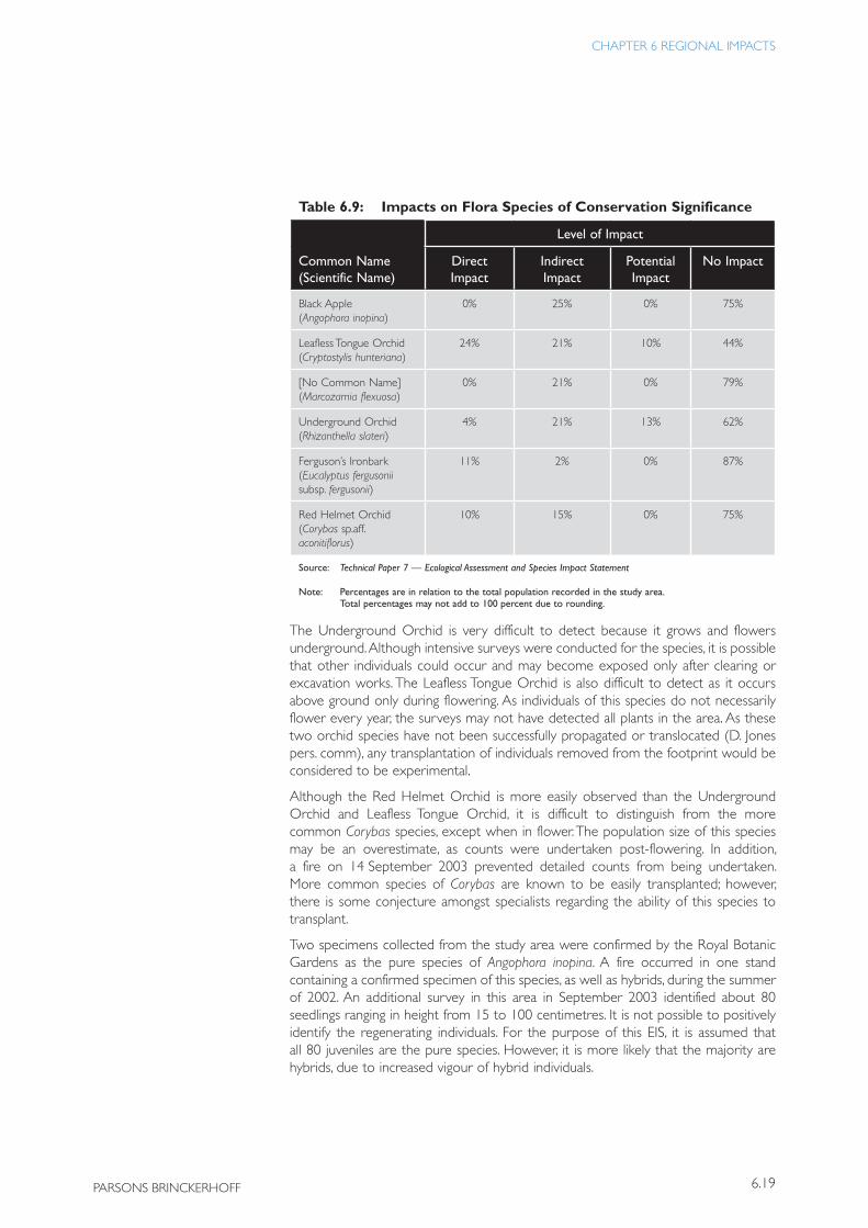
Table 6.9: Impacts on Flora Species of Conservation Significance
Level of Impact
Common Name (Scientific Name)
Direct Impact
Indirect Impact
Potential Impact
No Impact
Black Apple (Angophora inopina)
0% 25% 0% 75%
Leafless Tongue Orchid (Cryptostylis hunteriana)
24% 21% 10% 44%
[No Common Name] (Marcozamia flexuosa)
0% 21% 0% 79%
Underground Orchid (Rhizanthella slateri)
4% 21% 13% 62%
Ferguson’s Ironbark (Eucalyptus fergusonii subsp. fergusonii)
11% 2% 0% 87%
Red Helmet Orchid (Corybas sp.aff. aconitiflorus)
10% 15% 0% 75%
Source: Technical Paper 7 — Ecological Assessment and Species Impact Statement
Note: Percentages are in relation to the total population recorded in the study area. Total percentages may not add to 100 percent due to rounding.
The Underground Orchid is very difficult to detect because it grows and flowers underground. Although intensive surveys were conducted for the species, it is possible that other individuals could occur and may become exposed only after clearing or excavation works. The Leafless Tongue Orchid is also difficult to detect as it occurs above ground only during flowering. As individuals of this species do not necessarily flower every year, the surveys may not have detected all plants in the area. As these two orchid species have not been successfully propagated or translocated (D. Jones pers. comm), any transplantation of individuals removed from the footprint would be considered to be experimental.
Although the Red Helmet Orchid is more easily observed than the Underground Orchid and Leafless Tongue Orchid, it is difficult to distinguish from the more common Corybas species, except when in flower. The population size of this species may be an overestimate, as counts were undertaken post-flowering. In addition, a fire on 14 September 2003 prevented detailed counts from being undertaken. More common species of Corybas are known to be easily transplanted; however, there is some conjecture amongst specialists regarding the ability of this species to transplant.
Two specimens collected from the study area were confirmed by the Royal Botanic Gardens as the pure species of Angophora inopina. A fire occurred in one stand containing a confirmed specimen of this species, as well as hybrids, during the summer of 2002. An additional survey in this area in September 2003 identified about 80 seedlings ranging in height from 15 to 100 centimetres. It is not possible to positively identify the regenerating individuals. For the purpose of this EIS, it is assumed that all 80 juveniles are the pure species. However, it is more likely that the majority are hybrids, due to increased vigour of hybrid individuals.
BULAHDELAH — UPGRADING THE PACIF IC HIGHWAY
6.20 Roads and Traffic Authority
The impact on species resulting from the loss of individual plants varies depending on the species. The loss of up to 56 percent of the known population of Leafless Tongue Orchid within the study area may affect the long-term viability of this population to the east of Bulahdelah township. Overall, the removal of individuals belonging to threatened species is considered to be of at least State significance, taking into account the following:
• the population of the Leafless Tongue Orchid is the largest known; it is listed nationally; and has a conservation target of 100 percent in north-eastern NSW (Environment Australia 1999);
• the population of Black Apple is the most northerly location for this species, which has a conservation target of 100 percent in north-eastern NSW;
• the population of Underground Orchids is the largest one known; it has a conservation target of 80 percent in north-eastern NSW (Environment Australia 1999); and this is the type location for the species; and
• the population of Red Helmet Orchids is one of only two (possibly three) locations known for this species.
Terrestrial Fauna Species
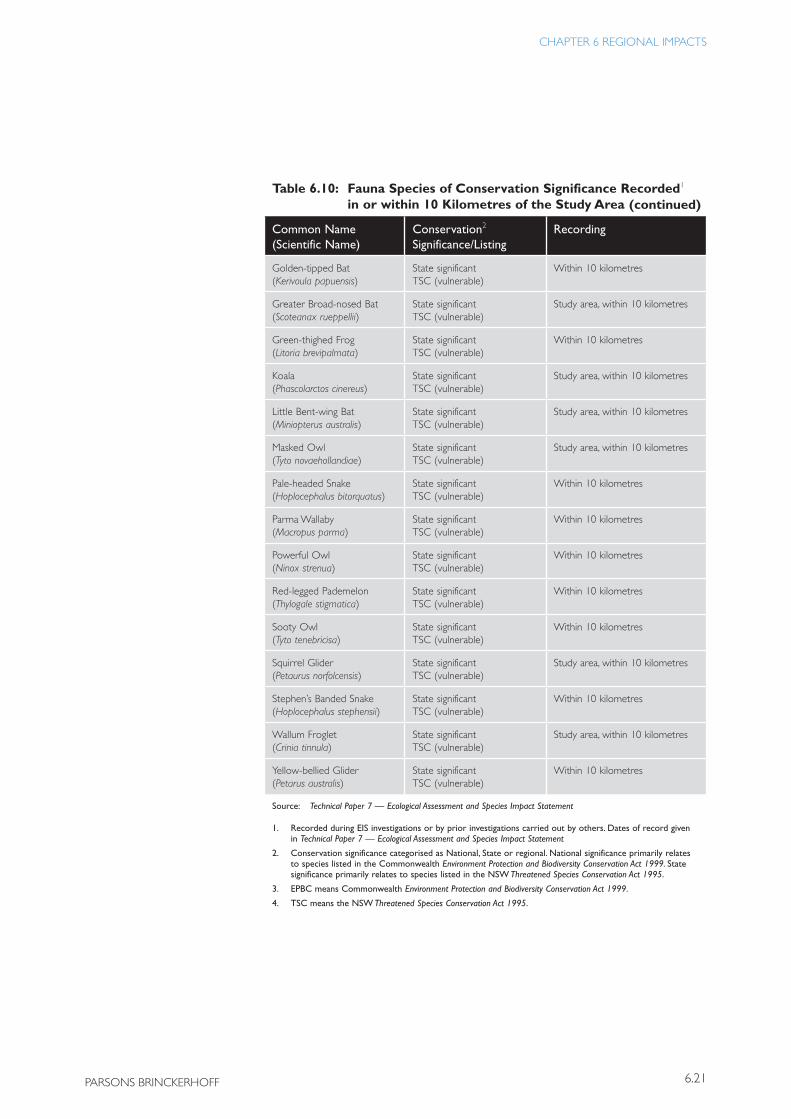
The locations of threatened fauna species recorded either within the study area or within a 10 kilometre radius are shown in Figure 6.5. Table 6.10 lists these species and identifies their conservation significance.
Table 6.10: Fauna Species of Conservation Significance Recorded1 in or within 10 Kilometres of the Study Area
Common Name (Scientific Name)
Conservation2
Significance/ListingRecording
Grey-headed Flying Fox (Pteropus poliocephalus)
Nationally significant EPBC (vulnerable)3
TSC (vulnerable)4
Study area
Spotted-tailed Quoll (Dasyurus maculatus)
Nationally significant EPBC (vulnerable)3 TSC (vulnerable)4
Within 10 kilometres
Stuttering Frog (Mixophyes balbus)
Nationally significant EPBC (vulnerable)3
TSC (vulnerable)4
Within 10 kilometres
Black-chinned Honeyeater (Melithreptus gularis)
State significant TSC (vulnerable)
Study area
Black-necked Stork (Xenorhynchus asiaticus)
State significant TSC (endangered)
Study area, within 10 kilometres
Common Bent-wing Bat (Miniopterus schreibersii)
State significant TSC (vulnerable)
Study area, within 10 kilometres
Eastern Freetail Bat (Mormopterus nofolkensis)
State significant TSC (vulnerable)
Study area, within 10 kilometres
Glossy Black Cockatoo (Calyptorhynchus lathami)
State significant TSC (vulnerable)
Study area, within 10 kilometres
Twenty-three fauna species of conservation significance have been recorded within 10 kilometres of the proposal
The Upgrade may affect the long-term viability of the recorded population of the Leafless Tongue Orchid
6.21
CHAPTER 6 REGIONAL IMPACTS
PARSONS BRINCKERHOFF
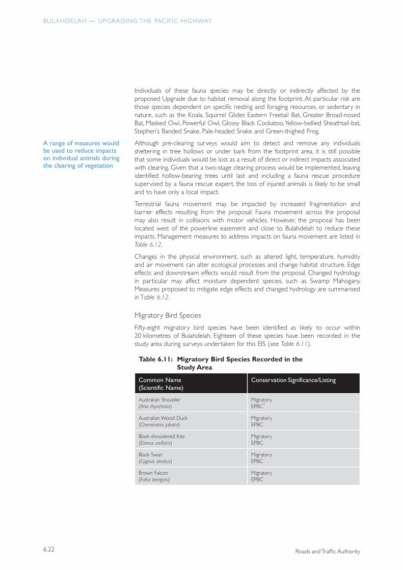
Table 6.10: Fauna Species of Conservation Significance Recorded1 in or within 10 Kilometres of the Study Area
Common Name (Scientific Name)
Conservation2
Significance/ListingRecording
Golden-tipped Bat (Kerivoula papuensis)
State significant TSC (vulnerable)
Within 10 kilometres
Greater Broad-nosed Bat (Scoteanax rueppellii)
State significant TSC (vulnerable)
Study area, within 10 kilometres
Green-thighed Frog (Litoria brevipalmata)
State significant TSC (vulnerable)
Within 10 kilometres
Koala (Phascolarctos cinereus)
State significant TSC (vulnerable)
Study area, within 10 kilometres
Little Bent-wing Bat (Miniopterus australis)
State significant TSC (vulnerable)
Study area, within 10 kilometres
Masked Owl (Tyto novaehollandiae)
State significant TSC (vulnerable)
Study area, within 10 kilometres
Pale-headed Snake (Hoplocephalus bitorquatus)
State significant TSC (vulnerable)
Within 10 kilometres
Parma Wallaby (Macropus parma)
State significant TSC (vulnerable)
Within 10 kilometres
Powerful Owl (Ninox strenua)
State significant TSC (vulnerable)
Within 10 kilometres
Red-legged Pademelon (Thylogale stigmatica)
State significant TSC (vulnerable)
Within 10 kilometres
Sooty Owl (Tyto tenebricisa)
State significant TSC (vulnerable)
Within 10 kilometres
Squirrel Glider (Petaurus norfolcensis)
State significant TSC (vulnerable)
Study area, within 10 kilometres
Stephen’s Banded Snake (Hoplocephalus stephensii)
State significant TSC (vulnerable)
Within 10 kilometres
Wallum Froglet (Crinia tinnula)
State significant TSC (vulnerable)
Study area, within 10 kilometres
Yellow-bellied Glider (Petarus australis)
State significant TSC (vulnerable)
Within 10 kilometres
Source: Technical Paper 7 — Ecological Assessment and Species Impact Statement
1. Recorded during EIS investigations or by prior investigations carried out by others. Dates of record given in Technical Paper 7 — Ecological Assessment and Species Impact Statement
2. Conservation significance categorised as National, State or regional. National significance primarily relates to species listed in the Commonwealth Environment Protection and Biodiversity Conservation Act 1999. State significance primarily relates to species listed in the NSW Threatened Species Conservation Act 1995.
3. EPBC means Commonwealth Environment Protection and Biodiversity Conservation Act 1999.
4. TSC means the NSW Threatened Species Conservation Act 1995.
(continued)
BULAHDELAH — UPGRADING THE PACIF IC HIGHWAY
6.22 Roads and Traffic Authority
Individuals of these fauna species may be directly or indirectly affected by the proposed Upgrade due to habitat removal along the footprint. At particular risk are those species dependent on specific nesting and foraging resources, or sedentary in nature, such as the Koala, Squirrel Glider, Eastern Freetail Bat, Greater Broad-nosed Bat, Masked Owl, Powerful Owl, Glossy Black Cockatoo, Yellow-bellied Sheathtail-bat, Stephen’s Banded Snake, Pale-headed Snake and Green-thighed Frog.
Although pre-clearing surveys would aim to detect and remove any individuals sheltering in tree hollows or under bark from the footprint area, it is still possible that some individuals would be lost as a result of direct or indirect impacts associated with clearing. Given that a two-stage clearing process would be implemented, leaving identified hollow-bearing trees until last and including a fauna rescue procedure supervised by a fauna rescue expert, the loss of injured animals is likely to be small and to have only a local impact.
Terrestrial fauna movement may be impacted by increased fragmentation and barrier effects resulting from the proposal. Fauna movement across the proposal may also result in collisions with motor vehicles. However, the proposal has been located west of the powerline easement and close to Bulahdelah to reduce these impacts. Management measures to address impacts on fauna movement are listed in Table 6.12.
Changes in the physical environment, such as altered light, temperature, humidity and air movement can alter ecological processes and change habitat structure. Edge effects and downstream effects would result from the proposal. Changed hydrology in particular may affect moisture dependent species, such as Swamp Mahogany. Measures proposed to mitigate edge effects and changed hydrology are summarised in Table 6.12.
Migratory Bird Species
Fifty-eight migratory bird species have been identified as likely to occur within 20 kilometres of Bulahdelah. Eighteen of these species have been recorded in the study area during surveys undertaken for this EIS (see Table 6.11).
Table 6.11: Migratory Bird Species Recorded in the Study Area
Common Name (Scientific Name)
Conservation Significance/Listing
Australian Shoveller (Ana rhynchotis)
Migratory EPBC1
Australian Wood Duck (Chenonetta jubata)
Migratory EPBC
Black-shouldered Kite (Elanus axillaris)
Migratory EPBC
Black Swan (Cygnus atratus)
Migratory EPBC
Brown Falcon (Falco berigora)
Migratory EPBC
A range of measures would be used to reduce impacts on individual animals during the clearing of vegetation
6.23
CHAPTER 6 REGIONAL IMPACTS
PARSONS BRINCKERHOFF
Table 6.11: Migratory Bird Species Recorded in the Study Area
Common Name (Scientific Name)
Conservation Significance/Listing
Cattle Egret (Ardea ibis)
JAMBA2 CAMBA3
Chestnut Teal (Ana gracilis)
Migratory EPBC
Collared Sparrowhawk (Accipiter cirrhocephalus)
Migratory EPBC
Great Egret (Ardea alba)
JAMBA CAMBA
Grey Teal (Anas gracilis)
Migratory EPBC
Nankeen Kestrel (Falco cenchroides)
Migratory EPBC
Pacific Black Duck (Anas superciliosa)
Migratory EPBC
Peregrine Falcon (Falco peregrinus)
Migratory EPBC
Rufus Fantail (Rhipidura rufifrons)
Migratory EPBC
Swamp Harrier (Circus approximans)
Migratory EPBC
Wedge-tailed Eagle (Aquila audax)
Migratory EPBC
Whistling Kite (Haliastur sphenurus)
Migratory EPBC
White-throated Needletail (Hirunda caudacutus)
JAMBA CAMBA
Source: Technical Paper 7 — Ecological Assessment and Species Impact Statement
1. EPBC means Commonwealth Environment Protection and Biodiversity Conservation Act 1999.
2. JAMBA means Japan–Australia Migratory Bird Agreement.
3. CAMBA means China–Australia Migratory Bird Agreement.
The study area does not support an ecologically significant proportion of any migratory bird species population and is not at the limit of any migratory species range. However, five of the identified migratory species are declining in north-eastern NSW. The species are:
• Blue-billed Duck;• Square-tailed Kite;• Osprey;• Swift Parrot; and• Regent Honeyeater.
(continued)
The study area does not support an ecologically significant proportion of any population of migratory bird species
BULAHDELAH — UPGRADING THE PACIF IC HIGHWAY
6.24 Roads and Traffic Authority
������������
�������������������
���������������������������������
����
�����
����
������
����
�����
����
����
�����
����
����
�����
����
����
����
����
����
����
����
����
����
����
�����
����
�����
����
����
�����
����
����
���
�����
� �
����������
�
��������������������
���������������������
������������������������
������������������
���������������������
�����������������������
��������������������
��������������������
���������������
��������������
����������������������
����������������������������
������������������
���������������������
��������������������
��������������������
��������������������
�����
���������������
����������
��������������������������
��������������������
����������������������
������������������������������������������������
����������
����������������
����� �������������
��������
����
����������
���
�����
�����
����
�
��������������
����������
������������������
�������������
����
����
�����
����
����
�����
����
�����
����
�����
����
����
�����
��������
�����������
����
����
�����
����
����
����
����
���
�����
����
�������������
���������������������
����
����������
�������������
����
�����������
���������������
���
�����������
��������������
������
�����
�������
��������
�������
��
�����������������������
�����������������
���������������������������
������������������������
��������������
6.25
CHAPTER 6 REGIONAL IMPACTS
PARSONS BRINCKERHOFF
The proposed Upgrade would not substantially modify, destroy or isolate any areas of important habitat for these five species. Further, it would not result in an invasive species becoming established in any important habitat and would not disrupt the life-cycle of a significant proportion of any migratory species.
Aquatic Flora and Fauna
The aquatic flora and fauna of the study area are of high local conservation significance as the area supports:
• a major watercourse providing fish habitat, the Myall River ;• important refuge and foraging resources for migratory bird species;• habitat for at least 21 fish species in the Myall and Crawford Rivers‘ catchment;• habitat for at least 42 families of macroinvertebrates; and• water bodies that provide habitat for resident Black-necked Storks.
The Myall Lakes area has national conservation significance, being listed as a Ramsar wetland site in 1999. Therefore, the wetlands and river systems of the study area, which drain into Myall Lakes, also have significance at a national level with regard to maintenance of water quality.
Eight fish species were recorded in the study area during surveys for the preparation of this EIS and a further 13 species have been previously recorded. None of the species is threatened.
Bridges and culverts would be designed in accordance with the Department of Primary Industries’ Why do Fish Need to Cross the Road? Fish Passage Requirements for Waterway Crossings (NSW Fisheries 2003) and related Fishnote (NSW Fisheries 1998).
The construction of the proposed twin bridges over the Myall River would require 4 piles to be constructed within the river. A preliminary construction method includes a piling rig mounted on a temporary barge during construction. Any large, submerged, dead trees encountered in the river during the construction of these support piles would be moved downstream away from construction but left in the river. Impacts of barge construction on the aquatic ecology of the Myall River would not be significant as there would not be a substantial alteration to water flow, adequate light would penetrate under the bridge, and no significant native riparian vegetation would need to be removed.
The proposed new northbound bridge over Frys Creek would be a single-span structure, similar to the existing southbound bridge. There would be no obstruction to streamflow and light would be provided by the space between the twin bridges. There is unlikely to be any adverse impact on the aquatic ecology of Frys Creek.
Wetlands are located on grazing land south of Myall River and to the east of the proposed alignment of the Upgrade. These wetlands are occasionally used by Black-necked Storks for foraging. Culverts would be provided under the proposed road embankment to allow stormwater runoff to maintain these wetlands. Runoff from the surface of the proposed Upgrade would be captured and treated in water quality basins prior to discharge. The construction and operation of the proposed Upgrade would have no adverse impact on these ephemeral wetlands or on the Black-neck Storks.
Fish passage in the Myall River would be maintained during construction
The Upgrade would have no adverse impact on ephemeral wetlands
BULAHDELAH — UPGRADING THE PACIF IC HIGHWAY
6.26 Roads and Traffic Authority
Management Measures
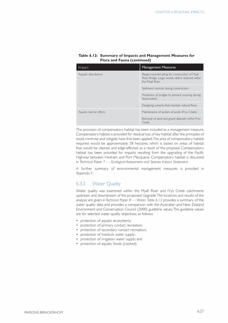
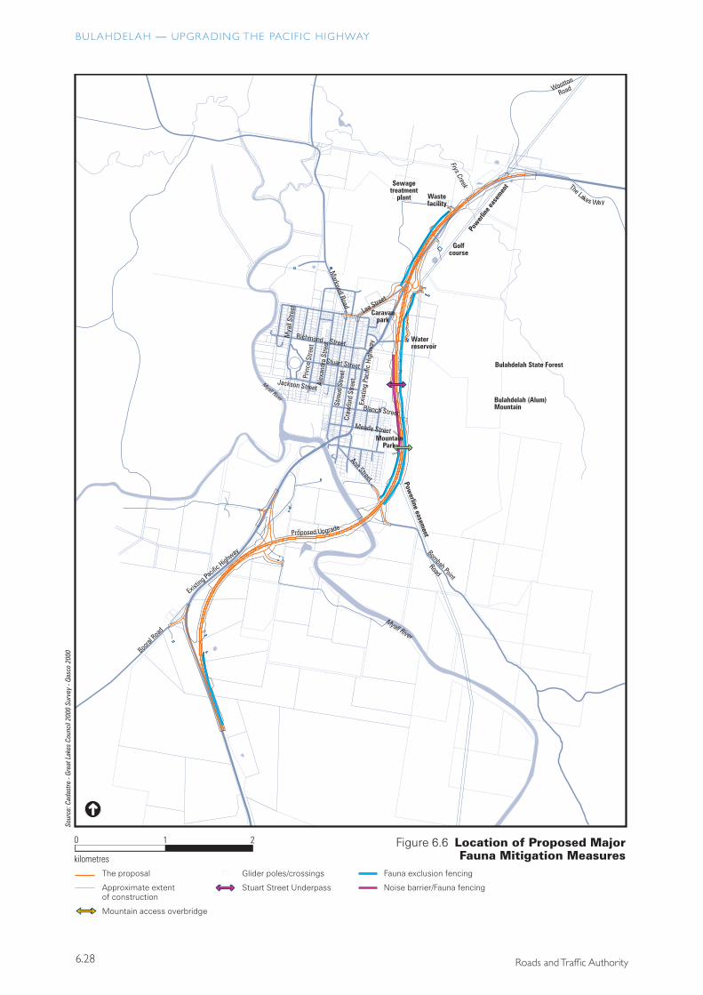
The route selection, design refinement and environmental assessment process resulted in the adoption of a range of measures that would avoid or minimise impacts on flora and fauna. The location of proposed major fauna mitigation measures are shown in Figure 6.6. Technical Paper 7 — Ecological Assessment and Species Impact Statement provides details of the measures proposed and includes discussion on additional measures to mitigate impacts on flora that would be further investigated. Table 6.12 provides a summary of the impacts and measures proposed to address those impacts.
Table 6.12: Summary of Impacts and Management Measures for Flora and Fauna
Impact Management Measures
Loss of rare or threatened flora species Removal and translocation
Seed collection and propagation of significant flora species
Fencing/parawebbing groups and individual species
Loss of rare or threatened fauna species Fauna rescue protocol established for clearing
Two-stage approach to clearing
Replacement of suitable roosting/nesting hollows
Loss of habitat Fencing/parawebbing the construction boundary
Landscaping roadside verges
Revegetating disturbed areas
Provision of compensatory habitat
Loss of habitat resources Hollow-bearing trees recorded and hollows recovered and replaced, or nest boxes provided
Seed from Allocasuarina stand at southern end used for revegetation of disturbed areas at southern end
Fragmentation, Terrestrial Barrier Effects and Road Mortality
Provisions to encourage fauna to use drainage and access structures (culverts, underpasses and bridges)
Fauna exclusion fencing
Squirrel Glider poles or wire ropes
Edge effects Noise barriers
Capture and treatment of road runoff
Provision of compensatory habitat
Changed hydrology (water quality, surface and subsurface flows)
Locating waterway crossings as close as possible to existing waterways.
Dissipating concentrated flows where possible
Capture and treatment of road runoff, including accidental spills
6.27
CHAPTER 6 REGIONAL IMPACTS
PARSONS BRINCKERHOFF
Table 6.12: Summary of Impacts and Management Measures for Flora and Fauna
Impact Management Measures
Aquatic disturbance Barge-mounted piling for construction of Myall River Bridge. Large woody debris retained within the Myall River
Sediment controls during construction
Protection at bridges to prevent scouring during flood events
Designing culverts that maintain natural flows
Aquatic barrier effects Maintenance of system of pools (Frys Creek)
Removal of sand and gravel deposits within Frys Creek
The provision of compensatory habitat has been included as a management measure. Compensatory habitat is provided for residual loss of key habitat after the principles of avoid, minimise and mitigate have first been applied. The area of compensatory habitat required would be approximately 58 hectares, which is based on areas of habitat that would be cleared, and edge-effected as a result of the proposal. Compensatory habitat has been provided for impacts resulting from the upgrading of the Pacific Highway between Hexham and Port Macquarie. Compensatory habitat is discussed in Technical Paper 7 — Ecological Assessment and Species Impact Statement.
A further summary of environmental management measures is provided in Appendix F.
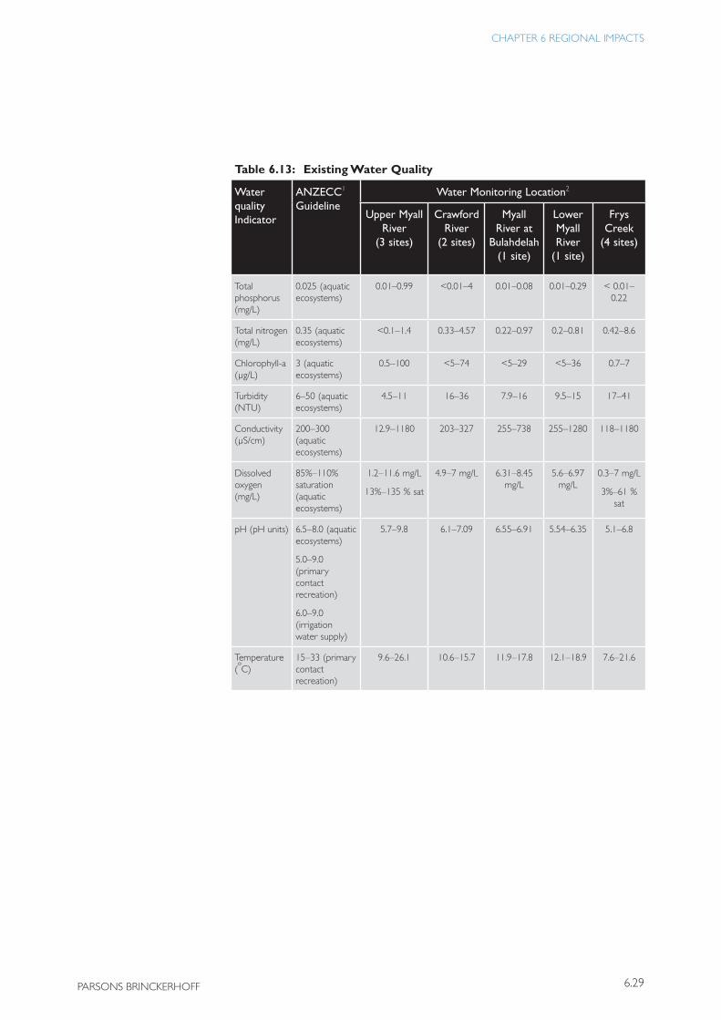
6.3.2 Water QualityWater quality was examined within the Myall River and Frys Creek catchments upstream and downstream of the proposed Upgrade. The locations and results of the analysis are given in Technical Paper 8 — Water. Table 6.13 provides a summary of the water quality data and provides a comparison with the Australian and New Zealand Environment and Conservation Council (2000) guideline values. The guideline values are for selected water quality objectives, as follows:
• protection of aquatic ecosystems;• protection of primary contact recreation;• protection of secondary contact recreation;• protection of livestock water supply;• protection of irrigation water supply; and• protection of aquatic foods (cooked).
(continued)
BULAHDELAH — UPGRADING THE PACIF IC HIGHWAY
6.28 Roads and Traffic Authority
����
�����
����
������
����
�����
����
����
�����
����
����
�����
����
����
���
� �
����������
�
��������������������
������������
���������������������������������
��������������������������
����������
����������������
����� �������������
��������
����
����������
���
�����
�����
����
�
��������������
����������
������������������
�������������
����
����
�����
����
����
�����
����
�����
����
�����
����
����
�����
��������
�����������
����
����
�����
����
����
����
����
���
�����
����
�������������
���������������������
����
����������
�������������
����
�����������
���������������
���
�����������
��������������
������
�����
�������
��������
�������
��
�����������������������
�����������������
���������������������������
��������������
����������������������
�����������������������
���������������������������������������������������������������
�����������������������
���������������������������
6.29
CHAPTER 6 REGIONAL IMPACTS
PARSONS BRINCKERHOFF
Table 6.13: Existing Water Quality
Water quality Indicator
ANZECC1
GuidelineWater Monitoring Location2
Upper Myall River
(3 sites)
Crawford River
(2 sites)
Myall River at
Bulahdelah(1 site)
Lower Myall River
(1 site)
Frys Creek
(4 sites)
Total phosphorus (mg/L)
0.025 (aquatic ecosystems)
0.01–0.99 <0.01–4 0.01–0.08 0.01–0.29 < 0.01–0.22
Total nitrogen (mg/L)
0.35 (aquatic ecosystems)
<0.1–1.4 0.33–4.57 0.22–0.97 0.2–0.81 0.42–8.6
Chlorophyll-a (µg/L)
3 (aquatic ecosystems)
0.5–100 <5–74 <5–29 <5–36 0.7–7
Turbidity (NTU)
6–50 (aquatic ecosystems)
4.5–11 16–36 7.9–16 9.5–15 17–41
Conductivity (µS/cm)
200–300 (aquatic ecosystems)
12.9–1180 203–327 255–738 255–1280 118–1180
Dissolved oxygen (mg/L)
85%–110% saturation (aquatic ecosystems)
1.2–11.6 mg/L
13%–135 % sat
4.9–7 mg/L 6.31–8.45 mg/L
5.6–6.97 mg/L
0.3–7 mg/L
3%–61 % sat
pH (pH units) 6.5–8.0 (aquatic ecosystems)
5.0–9.0 (primary contact recreation)
6.0–9.0 (irrigation water supply)
5.7–9.8 6.1–7.09 6.55–6.91 5.54–6.35 5.1–6.8
Temperature (ºC)
15–33 (primary contact recreation)
9.6–26.1 10.6–15.7 11.9–17.8 12.1–18.9 7.6–21.6
BULAHDELAH — UPGRADING THE PACIF IC HIGHWAY
6.30 Roads and Traffic Authority
Table 6.13: Existing Water Quality
Water quality Indicator
ANZECC1
GuidelineWater Monitoring Location2
Upper Myall River
(3 sites)
Crawford River
(2 sites)
Myall River at
Bulahdelah(1 site)
Lower Myall River
(1 site)
Frys Creek
(4 sites)
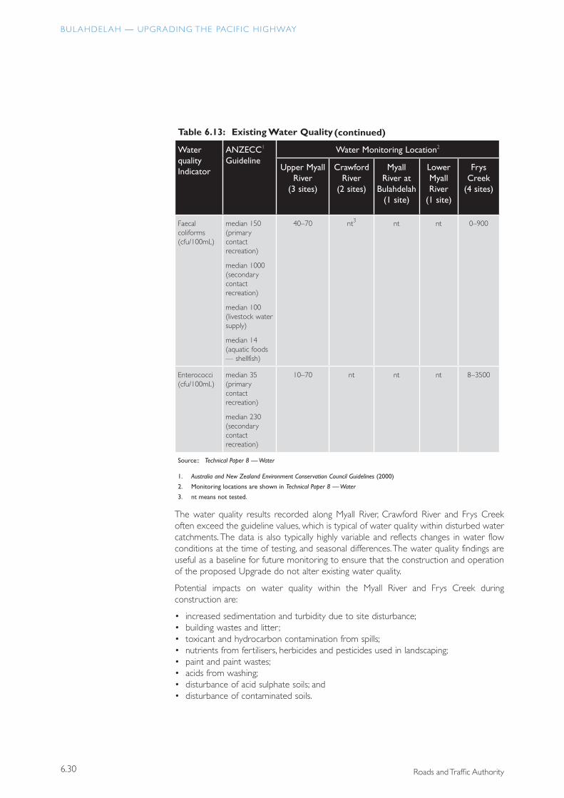
Faecal coliforms (cfu/100mL)
median 150 (primary contact recreation)
median 1000 (secondary contact recreation)
median 100 (livestock water supply)
median 14 (aquatic foods — shellfish)
40–70 nt3 nt nt 0–900
Enterococci (cfu/100mL)
median 35 (primary contact recreation)
median 230 (secondary contact recreation)
10–70 nt nt nt 8–3500
Source:: Technical Paper 8 — Water
1. Australia and New Zealand Environment Conservation Council Guidelines (2000)
2. Monitoring locations are shown in Technical Paper 8 — Water
3. nt means not tested.
The water quality results recorded along Myall River, Crawford River and Frys Creek often exceed the guideline values, which is typical of water quality within disturbed water catchments. The data is also typically highly variable and reflects changes in water flow conditions at the time of testing, and seasonal differences. The water quality findings are useful as a baseline for future monitoring to ensure that the construction and operation of the proposed Upgrade do not alter existing water quality.
Potential impacts on water quality within the Myall River and Frys Creek during construction are:
• increased sedimentation and turbidity due to site disturbance;• building wastes and litter ;• toxicant and hydrocarbon contamination from spills;• nutrients from fertilisers, herbicides and pesticides used in landscaping;• paint and paint wastes;• acids from washing;• disturbance of acid sulphate soils; and• disturbance of contaminated soils.
(continued)
6.31
CHAPTER 6 REGIONAL IMPACTS
PARSONS BRINCKERHOFF
There is no risk of impacts on water quality as a result of alum. Alum is soluble in water and any residual alum would have dissipated since its production prior to 1950.
Potential impacts on water quality during operation are the discharge of contaminants from road runoff and accidental spills into watercourses.
Measures to protect water quality during construction are of two kinds. These are: the inclusion of physical measures in the design aimed at settling out sediment and other materials from runoff during construction and operation; and the appropriate management of activities during construction aimed at minimising the production of elevated levels of suspended solids and pollutants in site runoff.
Sediment basins would be included in the proposal to intercept stormwater runoff from the construction site and to allow sediment to settle before discharge to natural watercourses or drainage structures crossing the alignment. These basins would normally be located close to existing or proposed drainage lines or adjacent to low areas along the proposed Upgrade. Sediment basins would be located to avoid sensitive areas wherever possible. Proposed locations and dimensions of sedimentation basins are given in Sections 5.10.5 and 5.10.6.
During operation of the proposed Upgrade, some sediment basins would be retained as water quality basins to capture road runoff and contain accidental spills if required. The locations of these structures are shown in Figure 5.24 and their volumes are shown in Table 5.8.
Particular attention would be taken on the placement and maintenance of water quality control structures during construction and operation to protect water quality within the catchment of SEPP 14 Wetland No. 698.
Potential water quality impacts and proposed management measures are discussed in more detail in Technical Paper 8 — Water and in Appendix F.
6.3.3 GreenhouseThe temperature of the earth’s atmosphere is determined by the balance between incoming solar radiation and the loss of heat energy by radiation from the earth and atmosphere to outer space. One of the important factors in determining the amount of radiant energy absorbed in the atmosphere is the concentration of carbon dioxide. Increases in carbon dioxide concentration are expected to cause increases in temperature.
Approximately 14 percent of total carbon dioxide emissions in NSW are estimated to come from the transport sector (Environment Protection Authority 1997a). At a broad level, the RTA has been involved in developing and implementing several strategic initiatives to address the issue of road-transport related greenhouse gas emissions, including the National Greenhouse Response Strategy, adopted by the Council of Australian Governments in 1992. The strategy aims to contribute to the national commitment to the National Strategy for Ecologically Sustainable Development (Commonwealth Department of Environment and Heritage 1992). The RTA contributed to the development of this strategy and is the NSW representative on the Transport Working Group for the development of a greenhouse gas emissions inventory. With respect to transport, the response strategies include reducing fuel consumption in motorised transport; improving the technical and economic efficiency of operation of the road network and traffic management; and encouraging the use of bicycles. This proposal contributes to these strategies.
A significant proportion of carbon dioxide emissions comes from the transport sector
Particular attention would be given to the protection of the catchments of SEPP 14 wetlands
BULAHDELAH — UPGRADING THE PACIF IC HIGHWAY
6.32 Roads and Traffic Authority
The RTA also continues to engage in other strategies to encourage the tightening of vehicle emissions standards. These include:
• enhancing the State’s vehicle emissions enforcement resources;• continuing to encourage the early implementation of more stringent Australian
Design Rules which will facilitate introduction of more advanced emission control technologies; and
• playing a key role in the development of the Diesel National Environment Protection Measure (NEPM).
Emissions of carbon dioxide from motor vehicles are directly proportional to fuel consumption. Emissions can only be reduced by technologies that result in improved fuel consumption. RTA programs that encourage better vehicle maintenance and hence better fuel economy would reduce carbon dioxide emissions.
It is estimated that approximately 13,500 tonnes of carbon dioxide would be emitted during the construction of the proposed Upgrade. During the first year of operation the travel efficiencies achieved as a result of the proposal would result in a fuel saving of approximately 320,000 litres and a reduction of 760 tonnes of carbon dioxide being emitted compared to the situation if the Upgrade were not built. The savings in carbon dioxide emissions would increase in each year of operation, and over 20 years a reduction in operational emission of 33,000 tonnes of carbon dioxide would be achieved. The proposal would therefore achieve a net reduction of approximately 19,500 tonnes of carbon dioxide over a 20-year period.
The RTA also supports the Commonwealth Government’s Measurables for a Better Environment package. This package includes measures to control emissions that impact on air quality. Measures include the introduction of Euro Standards for heavy vehicles and light vehicles, and low sulphur fuel (National Environment Protection Council 1999). A review of the Australian Design Rule (ADR-70) relating to diesel engines is also in progress. This will also contribute to controlling emissions from diesel vehicles, which will be particularly important for oxides of nitrogen and particulate matter emissions.
6.3.4 Energy, Waste and Demand on ResourcesEnergy usage, waste generation and demand on resources are discussed in Technical Paper 10.
Energy
Energy-consuming activities during construction of the proposal are extensive and would take place over approximately 4 years. Plant and equipment used during these activities are diverse, including large heavy machinery through to tools and small equipment. Energy is used in the form of fuel, and of electricity for lighting and equipment.
The activities, plant and equipment used during construction would use a considerable amount of fuel, estimated to be in the vicinity of 5 million litres, with most being diesel. Fuel use and efficiency are influenced by the condition of vehicles, speed of operation and the site conditions. Fuel and energy use during construction would be reduced by using efficient and well-maintained vehicles and by effective planning.
The proposed Upgrade would result in a net reduction in carbon dioxide emissions
6.33
CHAPTER 6 REGIONAL IMPACTS
PARSONS BRINCKERHOFF
Changes to fuel use can also be influenced by disruption to traffic on the existing Pacific Highway. However, as the majority of the construction activities are not on the operating highway, it would be expected to create little change in fuel use.
Energy consumption during operation of the Upgrade would be associated with vehicle use, provision of services, and vehicles and equipment involved in maintenance.
It is expected that the proposed Upgrade would result in energy savings, particularly in relation to improved operating conditions and reduced travel time, and hence reduced fuel consumption. Lower energy usage per vehicle is also expected for vehicles using the existing highway through Bulahdelah, as there would be lower traffic volumes and less congestion in peak holiday periods and therefore improved vehicle operating conditions.
It is estimated that in 2008, approximately 320,000 litres of fuel per annum would be saved due to the Upgrade, being a saving of approximately 10 percent. By the year 2028 these savings would have increased to 1.4 million litres of fuel per annum. Within approximately 9 years, operational savings would offset the estimated 5 million litres of fuel required for construction.
Energy-consuming services required for the operation of the Upgrade would include lighting, intelligent transport systems, and telephones. Electricity would be supplied by the existing electricity network, and would be negotiated between the RTA and local government authorities during detailed design.
Maintenance of the proposed Upgrade would include periodic attention to landscaping, maintenance of water treatment facilities and occasional pavement repairs. Maintenance is expected to involve a small number of medium-sized vehicles and equipment and energy consumption would be negligible.
Total operational energy use would gradually increase in proportion to the overall growth in traffic volumes on the highway.
Waste
Material excavated during construction would create a waste stream. Where suitable, earthworks material would be reused on-site as fill embankments and select sub-grade layers. Where practicable, other material would be reused on-site for batter extensions. Topsoil would be reused on-site for landscaping.
Another waste stream for the construction phase would be green waste, generated from clearing and grubbing activities. The total volume of green waste generated is difficult to estimate as the vegetation cover varies over the proposed alignment. However, the area requiring major clearing is approximately 35 hectares. Areas containing timber resources would be identified for harvesting and unsuitable material would be mulched, chipped or reused on-site for sediment filter fences and landscaping where appropriate. Suitable logs and limbs would also be used to provide habitat and fauna refuge, and to prevent access to construction areas.
Other forms of construction waste would include building waste generated from demolition and construction activities. There would be limited demolition required as part of the proposal.
Operational waste would comprise waste generated from maintenance activities and road users. Total annual quantities are likely to be in the order of 0.5 to 1 tonne per annum.
In the future, the operation of the Upgrade would save over 1 million litres of fuel each year compared to the operation of the existing road network
Where possible waste material would be reused on-site during construction
BULAHDELAH — UPGRADING THE PACIF IC HIGHWAY
6.34 Roads and Traffic Authority
Green waste from maintenance activities would be collected and wherever possible recycled for mulch within the road reserve or for other Great Lakes Council activities. Other maintenance wastes, such as oils and greases, would be disposed of to an appropriate facility.
Waste generated by road users would be collected by the relevant maintenance organisation. Wastes would be either recycled or disposed of to an appropriate facility.
A summary of environmental management measures is provided in Appendix F.
Demand on Resources
Water would be used during construction for dust control, washing of plant and equipment, for drinking water and for ablutions and toilets. It would also be used for the preparation of construction materials such as concrete and sub-grade. Water would be sourced from the local town water supplies and reticulated to the construction sites and compounds. Water would also be sourced from local waterways and sediment basins where appropriate.
It is estimated that 918,000 cubic metres of earthworks cut and 922,000 cubic metres of earthworks fill would be undertaken. Suitable materials from cuts would be used in fill embankments. An additional 200,000 cubic metres of material will be required for fill embankments, and will be sourced during the construction of the Karuah to Bulahdelah Upgrade further south. Additional materials required for construction would include concrete, steel and asphaltic concrete, and would be acquired from outside sources.
The entire Pacific Highway Upgrading Program has the potential to result in cumulative resource depletion. This impact has been minimised by considering the cut and fill requirements of this and neighbouring projects and waste minimisation and resource efficiency in accordance with the NSW Government’s Waste Reduction and Purchasing Policy (EPA 1999). In particular, using surplus material from the Karuah to Bulahdelah Upgrade project for the proposed Upgrade would minimise the cumulative impact of the program on local resources.
6.3.5 Overview of the Sustainability of the ProposalThe core principles of sustainability: the precautionary principle, intergenerational equity and the conservation of biological diversity, have guided the development of the proposed Upgrade of the Pacific Highway at Bulahdelah. The proposed route alignment and design have been developed to avoid and reduce impacts and where possible enhance the environmental, social and economic outcomes, both locally and regionally.
Considerable investigations have been undertaken to provide for well informed impact assessment. Where there has been uncertainty about environmental outcomes, the precautionary principle has been applied and measures have been adopted to establish greater certainty or protection. This is demonstrated by:
• the inclusion of measures to reduce unknown impacts on threatened species such as fauna bridges, recovery of tree hollows and measures to retain natural surface and sub-surface water flows;
• the translocation of threatened species, and the use of threatened species and
Waste minimisation and resource efficiency principles would be adopted in accordance with NSW Government policies
6.35
CHAPTER 6 REGIONAL IMPACTS
PARSONS BRINCKERHOFF
habitat resources for threatened species in revegetation works; • the provision of compensatory habitat; and • the provision of measures to treat road runoff.
The proposed Upgrade would ensure that the health, diversity and productivity of the environment are maintained or enhanced for the benefit of future generations. Measures that protect water quality, reductions in greenhouse gas emissions, efficient energy use during construction and operation, and application of the principles of reduce, reuse and recycle to waste management would ensure that the environment does not degrade in the future. Also, the protection of biological diversity by selecting a route that avoids impacts where possible, that applies mitigating measures in the concept design, and protects other important habitat as compensation also assists in maintaining the health and diversity of the environment into the future.
The development of the proposed Upgrade has been significantly influenced by the need to conserve biological diversity, while balancing other environmental, social and economic considerations. Refinement of the route alignment and concept design was undertaken to avoid or minimise impacts on species. Mitigating measures would be applied to residual impacts. Compensatory habitat has been provided to ensure the long term conservation of species and habitat diversity at a regional level.
6.4 Regional Cumulative ImpactsCumulative impacts are likely to arise from the interaction of the construction and operation of the proposed Upgrade of the Pacific Highway at Bulahdelah with other components of the Pacific Highway Upgrading Program, and with other major activities planned in the immediate region.
6.4.1 Strategic Assessment of the Pacific Highway Upgrading Program
Cumulative impact assessment requires an assessment of the combined effects of the proposal with the effects of other activities within the region or beyond. An examination of environmental assessment methodologies within the Pacific Highway Upgrading Program Strategic Assessment (Sinclair Knight Merz 2000) concluded that cumulative or strategic assessment was limited at a project level due to the wide scope and to the limited availability of regional baseline information. The Strategic Assessment provides lists of potential issues, interactions and indicators for strategic assessment of upgrading options. The interactions and measurable indicators are grouped into four groups; transport, economic, social and environmental.
Table 6.15 lists these interactions, measurable indicators and a response in relation to the Upgrade of the Pacific Highway at Bulahdelah within the context of the Pacific Highway Upgrading Program.
The route selection and design development processes have been significantly influenced by the need to conserve biological diversity
A strategic assessment of the impacts of the entire Pacific Highway Upgrading Program has previously been undertaken by the RTA
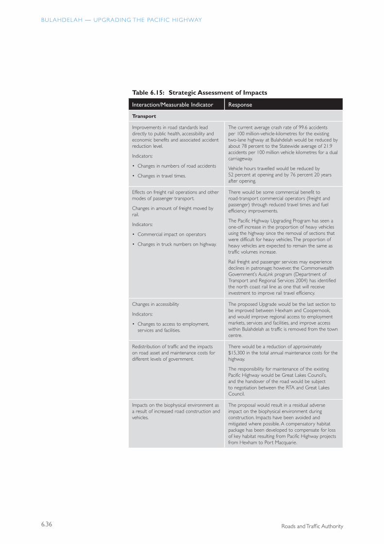
BULAHDELAH — UPGRADING THE PACIF IC HIGHWAY
6.36 Roads and Traffic Authority
Table 6.15: Strategic Assessment of Impacts
Interaction/Measurable Indicator Response
Transport
Improvements in road standards lead directly to public health, accessibility and economic benefits and associated accident reduction level.
Indicators:
• Changes in numbers of road accidents
• Changes in travel times.
The current average crash rate of 99.6 accidents per 100 million-vehicle-kilometres for the existing two-lane highway at Bulahdelah would be reduced by about 78 percent to the Statewide average of 21.9 accidents per 100 million vehicle kilometres for a dual carriageway.
Vehicle hours travelled would be reduced by 52 percent at opening and by 76 percent 20 years after opening.
Effects on freight rail operations and other modes of passenger transport.
Changes in amount of freight moved by rail.
Indicators:
• Commercial impact on operators
• Changes in truck numbers on highway.
There would be some commercial benefit to road-transport commercial operators (freight and passenger) through reduced travel times and fuel efficiency improvements.
The Pacific Highway Upgrading Program has seen a one-off increase in the proportion of heavy vehicles using the highway since the removal of sections that were difficult for heavy vehicles. The proportion of heavy vehicles are expected to remain the same as traffic volumes increase.
Rail freight and passenger services may experience declines in patronage; however, the Commonwealth Government’s AusLink program (Department of Transport and Regional Services 2004) has identified the north coast rail line as one that will receive investment to improve rail travel efficiency.
Changes in accessibility
Indicators:
• Changes to access to employment, services and facilities.
The proposed Upgrade would be the last section to be improved between Hexham and Coopernook, and would improve regional access to employment markets, services and facilities, and improve access within Bulahdelah as traffic is removed from the town centre.
Redistribution of traffic and the impacts on road asset and maintenance costs for different levels of government.
There would be a reduction of approximately $15,300 in the total annual maintenance costs for the highway.
The responsibility for maintenance of the existing Pacific Highway would be Great Lakes Council’s, and the handover of the road would be subject to negotiation between the RTA and Great Lakes Council.
Impacts on the biophysical environment as a result of increased road construction and vehicles.
The proposal would result in a residual adverse impact on the biophysical environment during construction. Impacts have been avoided and mitigated where possible. A compensatory habitat package has been developed to compensate for loss of key habitat resulting from Pacific Highway projects from Hexham to Port Macquarie.
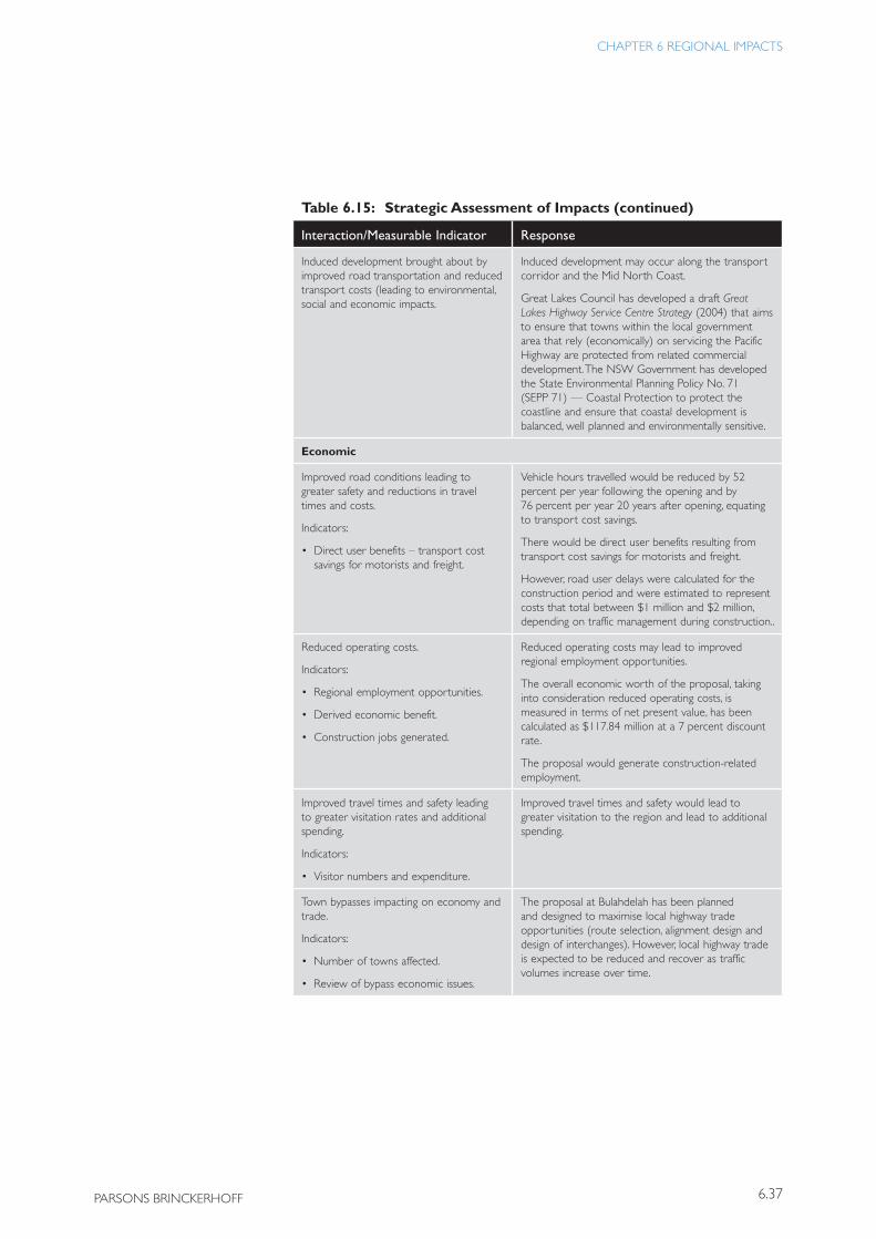
6.37
CHAPTER 6 REGIONAL IMPACTS
PARSONS BRINCKERHOFF
Table 6.15: Strategic Assessment of Impacts
Interaction/Measurable Indicator Response
Induced development brought about by improved road transportation and reduced transport costs (leading to environmental, social and economic impacts.
Induced development may occur along the transport corridor and the Mid North Coast.
Great Lakes Council has developed a draft Great Lakes Highway Service Centre Strategy (2004) that aims to ensure that towns within the local government area that rely (economically) on servicing the Pacific Highway are protected from related commercial development. The NSW Government has developed the State Environmental Planning Policy No. 71 (SEPP 71) — Coastal Protection to protect the coastline and ensure that coastal development is balanced, well planned and environmentally sensitive.
Economic
Improved road conditions leading to greater safety and reductions in travel times and costs.
Indicators:
• Direct user benefits – transport cost savings for motorists and freight.
Vehicle hours travelled would be reduced by 52 percent per year following the opening and by 76 percent per year 20 years after opening, equating to transport cost savings.
There would be direct user benefits resulting from transport cost savings for motorists and freight.
However, road user delays were calculated for the construction period and were estimated to represent costs that total between $1 million and $2 million, depending on traffic management during construction..
Reduced operating costs.
Indicators:
• Regional employment opportunities.
• Derived economic benefit.
• Construction jobs generated.
Reduced operating costs may lead to improved regional employment opportunities.
The overall economic worth of the proposal, taking into consideration reduced operating costs, is measured in terms of net present value, has been calculated as $117.84 million at a 7 percent discount rate.
The proposal would generate construction-related employment.
Improved travel times and safety leading to greater visitation rates and additional spending.
Indicators:
• Visitor numbers and expenditure.
Improved travel times and safety would lead to greater visitation to the region and lead to additional spending.
Town bypasses impacting on economy and trade.
Indicators:
• Number of towns affected.
• Review of bypass economic issues.
The proposal at Bulahdelah has been planned and designed to maximise local highway trade opportunities (route selection, alignment design and design of interchanges). However, local highway trade is expected to be reduced and recover as traffic volumes increase over time.
(continued)
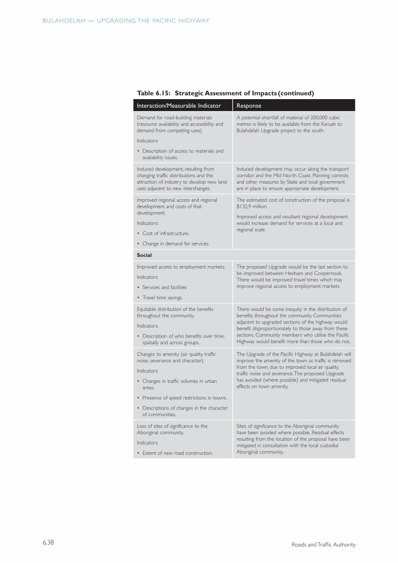
BULAHDELAH — UPGRADING THE PACIF IC HIGHWAY
6.38 Roads and Traffic Authority
Table 6.15: Strategic Assessment of Impacts
Interaction/Measurable Indicator Response
Demand for road-building materials (resource availability and accessibility and demand from competing uses).
Indicators:
• Description of access to materials and availability issues.
A potential shortfall of material of 200,000 cubic metres is likely to be available from the Karuah to Bulahdelah Upgrade project to the south.
Induced development, resulting from changing traffic distributions and the attraction of industry to develop new land uses adjacent to new interchanges.
Induced development may occur along the transport corridor and the Mid North Coast. Planning controls and other measures by State and local government are in place to ensure appropriate development.
Improved regional access and regional development and costs of that development.
Indicators:
• Cost of infrastructure.
• Change in demand for services.
The estimated cost of construction of the proposal is $132.9 million.
Improved access and resultant regional development would increase demand for services at a local and regional scale.
Social
Improved access to employment markets.
Indicators:
• Services and facilities
• Travel time savings.
The proposed Upgrade would be the last section to be improved between Hexham and Coopernook. There would be improved travel times which may improve regional access to employment markets.
Equitable distribution of the benefits throughout the community.
Indicators:
• Description of who benefits over time, spatially and across groups.
There would be some inequity in the distribution of benefits throughout the community. Communities adjacent to upgraded sections of the highway would benefit disproportionately to those away from these sections. Community members who utilise the Pacific Highway would benefit more than those who do not..
Changes to amenity (air quality, traffic noise, severance and character).
Indicators:
• Changes in traffic volumes in urban areas.
• Presence of speed restrictions in towns.
• Descriptions of changes in the character of communities.
The Upgrade of the Pacific Highway at Bulahdelah will improve the amenity of the town as traffic is removed from the town, due to improved local air quality, traffic noise and severance. The proposed Upgrade has avoided (where possible) and mitigated residual effects on town amenity.
Loss of sites of significance to the Aboriginal community.
Indicators:
• Extent of new road construction.
Sites of significance to the Aboriginal community have been avoided where possible. Residual effects resulting from the location of the proposal have been mitigated in consultation with the local custodial Aboriginal community.
(continued)
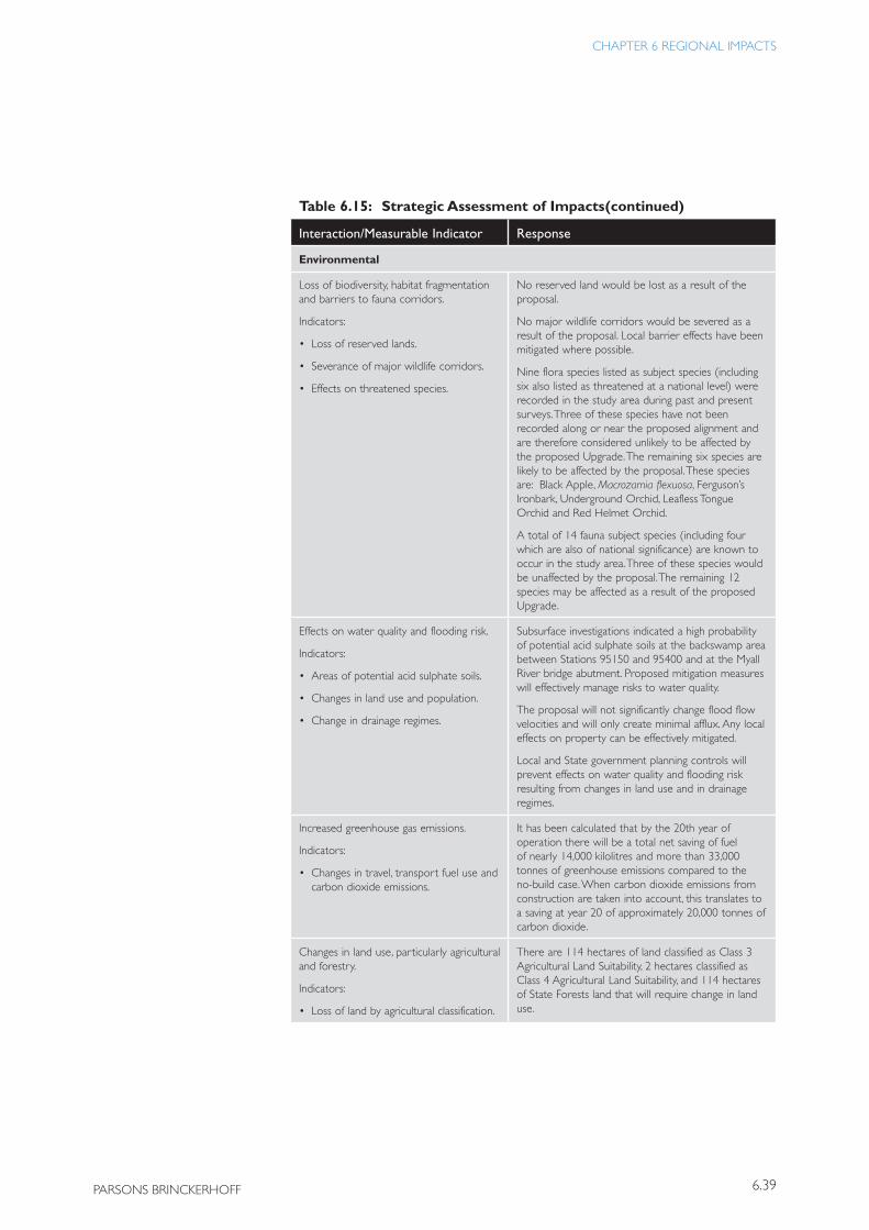
6.39
CHAPTER 6 REGIONAL IMPACTS
PARSONS BRINCKERHOFF
Table 6.15: Strategic Assessment of Impacts
Interaction/Measurable Indicator Response
Environmental
Loss of biodiversity, habitat fragmentation and barriers to fauna corridors.
Indicators:
• Loss of reserved lands.
• Severance of major wildlife corridors.
• Effects on threatened species.
No reserved land would be lost as a result of the proposal.
No major wildlife corridors would be severed as a result of the proposal. Local barrier effects have been mitigated where possible.
Nine flora species listed as subject species (including six also listed as threatened at a national level) were recorded in the study area during past and present surveys. Three of these species have not been recorded along or near the proposed alignment and are therefore considered unlikely to be affected by the proposed Upgrade. The remaining six species are likely to be affected by the proposal. These species are: Black Apple, Macrozamia flexuosa, Ferguson’s Ironbark, Underground Orchid, Leafless Tongue Orchid and Red Helmet Orchid.
A total of 14 fauna subject species (including four which are also of national significance) are known to occur in the study area. Three of these species would be unaffected by the proposal. The remaining 12 species may be affected as a result of the proposed Upgrade.
Effects on water quality and flooding risk.
Indicators:
• Areas of potential acid sulphate soils.
• Changes in land use and population.
• Change in drainage regimes.
Subsurface investigations indicated a high probability of potential acid sulphate soils at the backswamp area between Stations 95150 and 95400 and at the Myall River bridge abutment. Proposed mitigation measures will effectively manage risks to water quality.
The proposal will not significantly change flood flow velocities and will only create minimal afflux. Any local effects on property can be effectively mitigated.
Local and State government planning controls will prevent effects on water quality and flooding risk resulting from changes in land use and in drainage regimes.
Increased greenhouse gas emissions.
Indicators:
• Changes in travel, transport fuel use and carbon dioxide emissions.
It has been calculated that by the 20th year of operation there will be a total net saving of fuel of nearly 14,000 kilolitres and more than 33,000 tonnes of greenhouse emissions compared to the no-build case. When carbon dioxide emissions from construction are taken into account, this translates to a saving at year 20 of approximately 20,000 tonnes of carbon dioxide.
Changes in land use, particularly agricultural and forestry.
Indicators:
• Loss of land by agricultural classification.
There are 114 hectares of land classified as Class 3 Agricultural Land Suitability, 2 hectares classified as Class 4 Agricultural Land Suitability, and 114 hectares of State Forests land that will require change in land use.
(continued)
BULAHDELAH — UPGRADING THE PACIF IC HIGHWAY
6.40 Roads and Traffic Authority
Table 6.15: Strategic Assessment of Impacts
Interaction/Measurable Indicator Response
Changes in rural landscape values.
Indicators:
• Changes in scenic quality as assessed by length of new road construction.
The proposal is 8.5 kilometres. Approximately 5.75 kilometres can be regarded as new road construction, with the remainder being an upgrade of the existing.
Changes to urban settlement form and character.
Indicators:
• Relief from traffic for towns with landscape of heritage value.
There will be substantial improvement to the urban (village) settlement form and character of Bulahdelah with the removal of Pacific Highway traffic from within the town.
6.4.2 Interactions with Other Major ActivitiesThere is only one other major activity identified within the vicinity that would interact with the Upgrade of the Pacific Highway at Bulahdelah. The Upgrade would be constructed either concurrently with the final stage of the Karuah to Bulahdelah upgrade further to the south, or immediately following. This provides an opportunity for some efficiency in the use of resources. In particular, a 200,000 cubic metre shortfall in fill material at Bulahdelah would be made up of excess material from the Karuah to Bulahdelah construction, reducing the need for gaining material from external sources. This would reduce the need for additional environmental and other impacts and costs. If the construction was to be done concurrently, there would also be efficiencies in employment and the utilisation of construction equipment.
(continued)