Embed Size (px)
Citation preview
C HAPTER 2
C HAPTER 3
CHAPTER 4
CHAPTER 5
CHAPTER 6
CHAPTER 7
CHAPTER 8
CHAPTER 9
C HAPTER 1
IntroductionIntroductionIntroductionIntroduction CHAPTER
Strategic FrameworkStrategic FrameworkStrategic FrameworkStrategic Framework
CHAPTER
HousingHousingHousingHousing
CHAPTER
Economic Development & TourismEconomic Development & TourismEconomic Development & TourismEconomic Development & Tourism
CHAPTER
Natural, Historic & Built EnvironmentNatural, Historic & Built EnvironmentNatural, Historic & Built EnvironmentNatural, Historic & Built Environment
CHAPTER
Town Centres & RetailingTown Centres & RetailingTown Centres & RetailingTown Centres & Retailing
CHAPTER
TransportationTransportationTransportationTransportation
CHAPTER
Infrastructure & Community FacilitInfrastructure & Community FacilitInfrastructure & Community FacilitInfrastructure & Community Facilitiesiesiesies
CHAPTER
Leisure & RecreationLeisure & RecreationLeisure & RecreationLeisure & Recreation
CHAPTER
Criteria Used to Define Settlement Framework Boundaries – Appendix 1 Important Open Spaces – Appendix 2
Sites of Special Scientific Interest and Derbyshire Wildlife Sites – Appendix 3 Car Parking Guidelines – Appendix 4
Local Plan Corporate Check – Appendix 5 Local Plan Sustainability Appraisal – Appendix 6
FOREWARD
On 24 November 2005 the Council resolved to adopt the Derbyshire Dales Local Plan with modifications. The plan came into operation on that date.
The adopted plan will form the development plan and the basis for decisions on land use planning for the area of Derbyshire Dales outside the Peak District National Park.
The Derbyshire Dales is an area of immense character comprising a splendid landscape of hills and valleys together with a wealth of attractive buildings, open spaces, towns and villages. As Local Planning Authority, the District Council have a great responsibility in discharging our statutory planning functions and it is one which the Council’s members and Officers take very seriously.
Through the implementation of our planning policies, the Council seeks to protect and enhance the natural and built environment of the Derbyshire Dales whilst also securing the development of sustainable communities, providing homes, jobs, social and community facilities. At all times, we will endeavour to act in the best interests of the environment, respect the needs of residents, and seek to assist businesses which provide local employment.
The policies and proposals contained within this plan will guide and control development and change within the Derbyshire Dales for many years to come.
Councillor Lewis Rose
Leader, Derbyshire Dales District
INDEX OF POLCIES AND PROPOSALS
Chapter 2 – Strategic Framework
Page
Policy SF1 Development Within Settlement Frameworks Boundaries 6
Policy SF2 Protection of Important Open Spaces 7
Policy SF3 Development Conspicuous From The Peak National Park 8
Policy SF4 Development In The Countryside 8
Policy SF5 Design And Appearance of Development 9
Policy SF6 Protection Of The Best Agricultural Land 10
Policy SF7 Waste Management And Recycling 11
Policy SF8 Catering For The Needs Of People With Disabilities In Development And Redevelopment
11
Chapter 3 - Housing
Policy H1 New Housing Development Within Settlement Framework Boundaries 18
Policy H2 Extensions to Dwellings 19
Policy H3 Dependent Persons Units 19
Policy H4 Housing Development Outside Settlement Framework Boundaries 20
Policy H5 Conversion And Re-Use Of Buildings To Provide Residential Accommodation Outside Settlement Frameworks
20
Policy H6 Replacement Dwellings In The Countryside 21
Policy H7 New Dwellings For Agricultural Or Forestry Workers Or Rural Based Enterprises In The Countryside
22
Policy H8 Extending Domestic Curtilages Into The Countryside 23
Policy H9 Design And Appearance Of New Housing 23
Policy H10 Affordable Housing Within The Settlement Framework Of Market Towns 27
Policy H11 Affordable Housing Within The Settlement Frameworks Of Other Settlements 27
Policy H12 Alternative Provision For Affordable Housing Outside Settlement Frameworks 28
Policy H13 Affordable Housing Exceptional Sites In Rural Areas 29
Policy H14 Housing To Meet The Needs Of The Elderly And People With Disabilities 30
Policy H15 Accommodation For Gypsies 30
Chapter 4 – Economic Development & Tourism
Page
Policy EDT1 Land For General Industrial And Business Development 39
Policy EDT2 Existing Strategic Employment Land And Business Premises 39
Policy EDT3 Redevelopment Of Land At Clifton Road Ashbourne 40
Policy EDT4 Other Existing Employment Land And Business Premises 40
Policy EDT5 Industrial And Business Development Within Settlement Frameworks 41
Policy EDT6 Conversion And Re-Use Of Buildings For Industrial And Business Development Within Settlement Frameworks
41
Policy EDT7 Extension And Expansion Of Existing Industrial And Premises 41
Policy EDT8 Design And Appearance Of New Industrial And Business Premises 42
Policy EDT9 Provision For People With Disabilities In Schemes For Employment Purposes 42
Policy EDT10 Industrial Development Involving Hazardous Or Pollutant Substances 43
Policy EDT11 Retail Uses Within Employment Areas 43
Policy EDT12 Haulage Operations 44
Policy EDT13 Buildings Associated With Agriculture, Forestry Or Other Rural Based Enterprise
45
Policy EDT14 Farm Diversification 45
Policy EDT15 New Build Industrial And Business Development Outside Of Settlement Frameworks
46
Policy EDT16 Re-Use Of Rural Building For Industrial And Business Use 46
Policy EDT17 Tourist Attractions 47
Policy EDT18 Tourist Accommodation Within The Settlement Frameworks Of Market Towns And Other Settlements
47
Policy EDT19 Tourist Accommodation Outside Defined Settlement Frameworks 48
Policy EDT20 Holiday Chalets, Caravan And Camp Site Developments 49
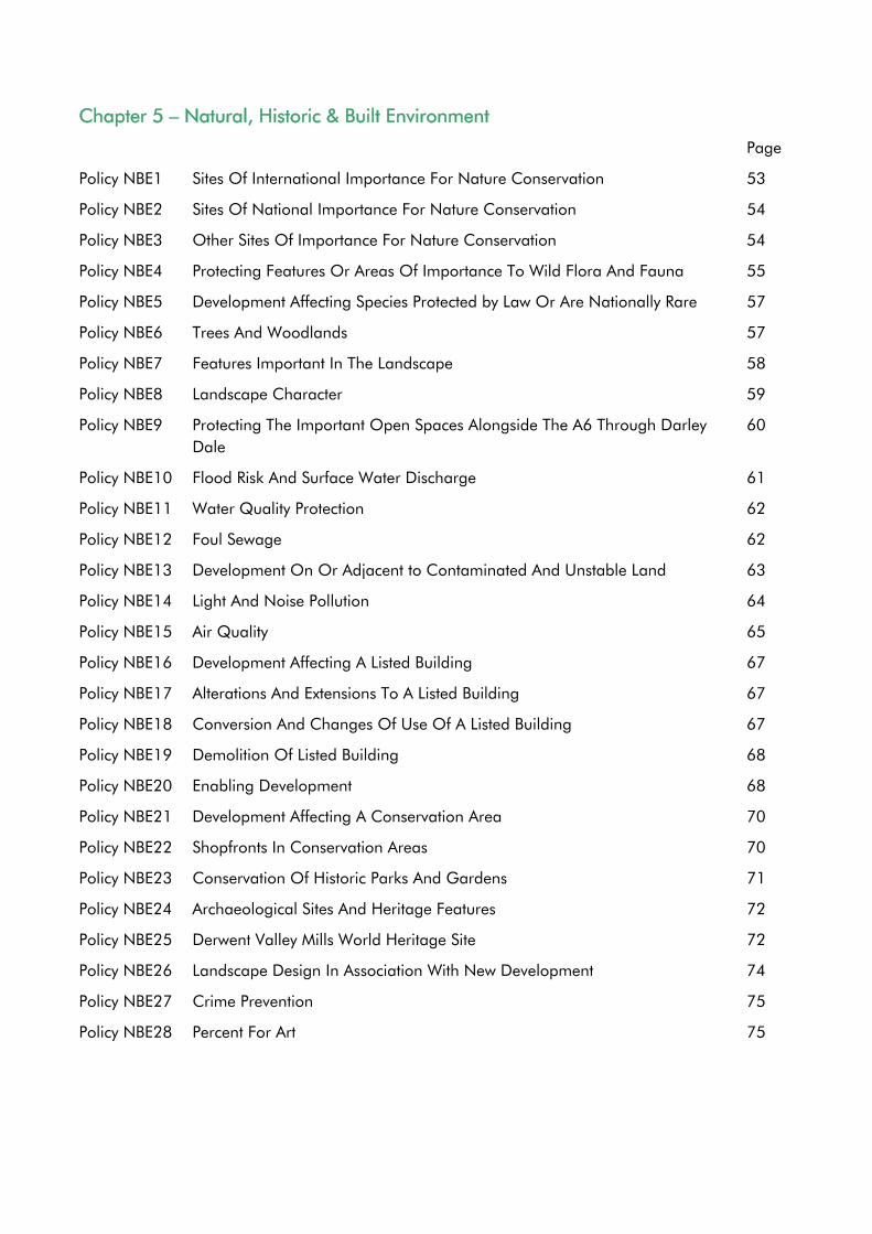
Chapter 5 – Natural, Historic & Built Environment
Page
Policy NBE1 Sites Of International Importance For Nature Conservation 53
Policy NBE2 Sites Of National Importance For Nature Conservation 54
Policy NBE3 Other Sites Of Importance For Nature Conservation 54
Policy NBE4 Protecting Features Or Areas Of Importance To Wild Flora And Fauna 55
Policy NBE5 Development Affecting Species Protected by Law Or Are Nationally Rare 57
Policy NBE6 Trees And Woodlands 57
Policy NBE7 Features Important In The Landscape 58
Policy NBE8 Landscape Character 59
Policy NBE9 Protecting The Important Open Spaces Alongside The A6 Through Darley Dale
60
Policy NBE10 Flood Risk And Surface Water Discharge 61
Policy NBE11 Water Quality Protection 62
Policy NBE12 Foul Sewage 62
Policy NBE13 Development On Or Adjacent to Contaminated And Unstable Land 63
Policy NBE14 Light And Noise Pollution 64
Policy NBE15 Air Quality 65
Policy NBE16 Development Affecting A Listed Building 67
Policy NBE17 Alterations And Extensions To A Listed Building 67
Policy NBE18 Conversion And Changes Of Use Of A Listed Building 67
Policy NBE19 Demolition Of Listed Building 68
Policy NBE20 Enabling Development 68
Policy NBE21 Development Affecting A Conservation Area 70
Policy NBE22 Shopfronts In Conservation Areas 70
Policy NBE23 Conservation Of Historic Parks And Gardens 71
Policy NBE24 Archaeological Sites And Heritage Features 72
Policy NBE25 Derwent Valley Mills World Heritage Site 72
Policy NBE26 Landscape Design In Association With New Development 74
Policy NBE27 Crime Prevention 75
Policy NBE28 Percent For Art 75
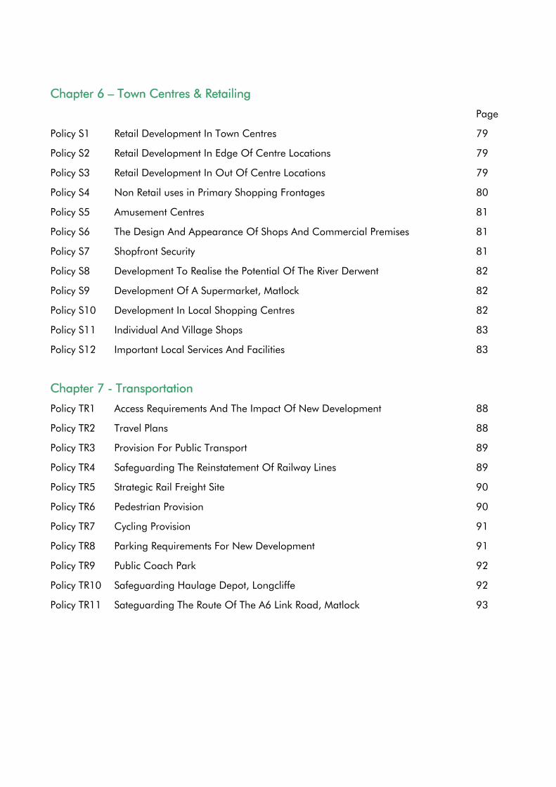
Chapter 6 – Town Centres & Retailing
Page
Policy S1 Retail Development In Town Centres 79
Policy S2 Retail Development In Edge Of Centre Locations 79
Policy S3 Retail Development In Out Of Centre Locations 79
Policy S4 Non Retail uses in Primary Shopping Frontages 80
Policy S5 Amusement Centres 81
Policy S6 The Design And Appearance Of Shops And Commercial Premises 81
Policy S7 Shopfront Security 81
Policy S8 Development To Realise the Potential Of The River Derwent 82
Policy S9 Development Of A Supermarket, Matlock 82
Policy S10 Development In Local Shopping Centres 82
Policy S11 Individual And Village Shops 83
Policy S12 Important Local Services And Facilities 83
Chapter 7 - Transportation
Policy TR1 Access Requirements And The Impact Of New Development 88
Policy TR2 Travel Plans 88
Policy TR3 Provision For Public Transport 89
Policy TR4 Safeguarding The Reinstatement Of Railway Lines 89
Policy TR5 Strategic Rail Freight Site 90
Policy TR6 Pedestrian Provision 90
Policy TR7 Cycling Provision 91
Policy TR8 Parking Requirements For New Development 91
Policy TR9 Public Coach Park 92
Policy TR10 Safeguarding Haulage Depot, Longcliffe 92
Policy TR11 Sateguarding The Route Of The A6 Link Road, Matlock 93
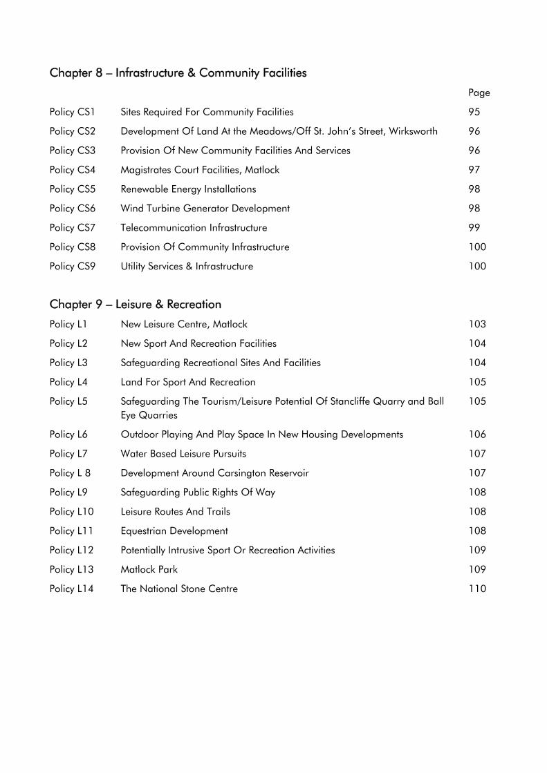
Chapter 8 – Infrastructure & Community Facilities
Page
Policy CS1 Sites Required For Community Facilities 95
Policy CS2 Development Of Land At the Meadows/Off St. John’s Street, Wirksworth 96
Policy CS3 Provision Of New Community Facilities And Services 96
Policy CS4 Magistrates Court Facilities, Matlock 97
Policy CS5 Renewable Energy Installations 98
Policy CS6 Wind Turbine Generator Development 98
Policy CS7 Telecommunication Infrastructure 99
Policy CS8 Provision Of Community Infrastructure 100
Policy CS9 Utility Services & Infrastructure 100
Chapter 9 – Leisure & Recreation
Policy L1 New Leisure Centre, Matlock 103
Policy L2 New Sport And Recreation Facilities 104
Policy L3 Safeguarding Recreational Sites And Facilities 104
Policy L4 Land For Sport And Recreation 105
Policy L5 Safeguarding The Tourism/Leisure Potential Of Stancliffe Quarry and Ball Eye Quarries
105
Policy L6 Outdoor Playing And Play Space In New Housing Developments 106
Policy L7 Water Based Leisure Pursuits 107
Policy L 8 Development Around Carsington Reservoir 107
Policy L9 Safeguarding Public Rights Of Way 108
Policy L10 Leisure Routes And Trails 108
Policy L11 Equestrian Development 108
Policy L12 Potentially Intrusive Sport Or Recreation Activities 109
Policy L13 Matlock Park 109
Policy L14 The National Stone Centre 110

CHAPTER 1
Introduction
The Derbyshire Dales
1.1 Derbyshire Dales covers an area of approximately 79,000 hectares (307 sq. miles). The area comprises some of the most diverse and scenically beautiful areas in Britain. The Peak District National Park covers over half the area of Derbyshire Dales.
1.2 The Local Plan covers that part of the Derbyshire Dales that lies outside the National Park. It covers approximately 33,000 hectares (128 sq. miles) of land with a total population of about 45000. The plan area is shown on Map 1.
1.3 The district is mostly rural in character and comprises attractive areas of countryside interspersed with a large number of villages and hamlets. The largest settlements within the plan area are Matlock (population 9700), Darley Dale (population 5200), Wirksworth (population 5100) and Ashbourne (population 7000).
The Process
1.4 The Council is required, under the Town and Country Planning Act 1990, to maintain an up to date Local Plan for that part of the District for which it is local planning authority. In this instance the Council is Local Planning Authority for that part of Derbyshire Dales outside of the Peak District National Park.
1.5 The policies and proposals in the Local Plan will be used to guide the use and the development of land across the District for the period up to 2011. Planning applications for all forms of development will be rigorously examined against the policies and proposals in this Local Plan.
1.6 Under the provisions of the Planning and Compulsory Purchase Act 2004, the policies and proposals in the Local Plan will be “saved” for a period of 3 years.
During this time the Council will be moving forward with the preparation of documents for inclusion in the Local Development Framework.
Implementation of Local Plan Policies and Proposals
1.7 The policies and proposals in the Local Plan should be read as a whole. All the relevant development plan policies will be taken into consideration when determining a planning application.
Form and Content of the Local Plan
1.8 The Local Plan comprises of a Written Statement and a Proposals Map. The Written Statement sets out the Council’s planning policies and proposals. Although some of these policies apply to the whole of the Local Plan area, the Proposals Map identifies those locations where particular policies and proposals apply.
1.9 Chapter 2 sets out the strategic framework, and Chapter 3 sets out the housing policies and proposals. Economic development and tourism polices are set out in Chapter 4. Policies on the natural, historic and built environment are set out in Chapter 5. Policies on town centres and retailing, transportation, infrastructure and community facilities and leisure and recreation are set out in Chapters 6, 7, 8, and 9 respectively.
1.10 The policies and proposals of the plan are printed in bold to clearly identify them. The policies cannot be read in isolation, they must read as a whole, since more than one policy may be applicable to any given development proposal.
1
Policy Context for the Plan
1.11 The Derbyshire Dales Local Plan has been prepared having had regard to national planning policies, regional spatial strategy and the provisions of the Derby and Derbyshire Joint Structure Plan.
National Planning Policy
1.12 The Government’s planning policies are set out in Planning Policy Guidance Notes (PPGs) and Planning Policy Statements (PPSs). Local planning authorities are required to take them into account in preparing development plans and when making decisions on planning applications.
Regional Spatial Strategy
1.13 Following the enactment of the Planning & Compulsory Purchase Act 2004 the Regional Spatial Strategy now forms part of the statutory development plan. RPG8 therefore becomes RSS8 and this replaces the RPG8 published in January 2002. Following the provisions of the new Act all statutory planning documents must now be in general conformity with its policies. Regional Spatial Strategy for the East Midlands (RSS8) sets broad strategic policies for land use and development in the East Midlands for a period up to 2021 and was published March 2005. RSS8 has been published since the approval of the Structure Plan and in some instances provides more up –to date strategic advice. In these circumstances the more recent advice must be taken fully into consideration in the determination of policies and proposals.
The Derby and Derbyshire Joint Structure Plan
1.14 The Derby and Derbyshire Joint Structure Plan sets out the key strategic policies for Derby and Derbyshire outside of the Peak District National Park. It provides the framework within which the Local Plan has to be prepared. However as indicated in paragraph 1.13 above, the more recent strategic guidance provided by RSS8 must also be considered
Key Aims and Objectives
1.15 The concept of ‘sustainable development’ is at the centre of Government policy. The most commonly used definition is “development that meets the needs of the present without compromising the ability of future generations to meet their own needs”.
1.16 Sustainable development is quite simply about ensuring a better quality of life for everyone. It is the recognition that the economy, the environment and our social well being are interdependent. It means making decisions that allows necessary development to take place, and at the same time, protect and where possible enhance the environment.
1.17 The Derbyshire Dales Community Strategy, prepared under the auspices of the Derbyshire Dales and High Peak Local Strategic Partnership has set out a vision for Derbyshire Dales of;
“Working in Partnership to keep the Derbyshire Dales one of the best places to live, work and visit”.
It sets out two main aims;
• To safeguard and improve the quality of life of people living in Derbyshire Dales;
• To protect and enhance the environment of the Derbyshire Dales;
2
It has also identified six priority themes; Housing, Health, Culture and Heritage, Crime and Community Safety, Rural Transport, and Economic Prosperity.
1.18 The Council has recently adopted a new Corporate Plan for 2003-2007. This builds upon the Community Strategy, and sets out seven key priority objectives for the four year period;
• Improve the supply of decent, affordable homes for local people
• Increase the number of people, especially young people, participating in leisure activities
• Reduce, re-use and recycle waste
• Protect and improve the safety and health of residents and visitors
• Stimulate economic, community and environmental regeneration
• Improve access to services
• Support service delivery improvements
1.19 The Local Plan can assist the Council achieve the aims of the Community Strategy and the priorities in it’s Corporate Plan by delivering the land use elements. The policies and proposals in the Local Plan therefore seek to reflect national, regional and strategic planning policy guidance, and the Council’s aims and priorities.
1.20 The policies and proposals in the Derbyshire Dales Local Plan will seek to meet the Council’s priorities in the following ways:
1.21 Improve the supply of decent, affordable homes for local people • Ensuring that there is sufficient
housing land to meet the identified requirements;
• Negotiating on housing sites the provision of affordable, and other specialist housing to meet identified needs.
1.22 Increase the number of people, especially young people, participating in leisure activities • Resisting the loss of existing, and
encouraging the development of new leisure, recreation, and community facilities.
1.23 Improve access to services and support service delivery improvements • Concentrating housing,
employment services and other development within the built up areas of settlements;
• Ensuring that infrastructure, services, and community facilities, where required, are provided as part of new development;
• Resisting the loss of important services and facilities in rural settlements;
• Seeking to encourage development in locations well related to the public transport network.
1.24 Protect and improve the safety and health of residents and visitors • Ensuring that infrastructure,
services, and community facilities, where required, are provided as part of new development;
• Ensuring that new development takes account of the risk of flooding and does not have an adverse impact upon water quality and;
• Ensuring that development does not have an adverse impact upon air quality;
• Resisting the loss of existing, and encouraging the development of new leisure, recreation, and community facilities;
• Giving preference to development that encourages the use of cycling, & walking, as an alternative to the private car;
• Encouraging new development to achieve the Secured by Design standard.
3
1.25 Reduce, recycle and re-use waste • Giving preference to development
that makes effective use of previously developed land;
• Encouraging the re-use of construction materials, and the provision of recycling facilities as an integral component of development proposals.
1.26 Stimulate economic, community and environmental regeneration • Concentrating housing,
employment services and other development within the built up areas of settlements;
• Ensuring that infrastructure, services, and community facilities, where required, are provided as part of new development;
• Resisting development in unsustainable locations;
• Resisting the loss of important services and facilities in rural settlements;
• Encouraging high standards of design for new development, and resisting poor quality design;
• Ensuring that new development protects and enhances the character and appearance of towns, and villages throughout the District;
• Giving preference to development that makes effective use of previously developed land;
• Seeking to protect and enhance biodiversity throughout the District, including wildlife habitats, species, trees and hedgerows;
• Ensuring that new development does not have an adverse impact on the local landscape character;
• Protecting the best and most versatile agricultural land and soils from development;
• Ensuring that new development takes account of the risk of flooding and does not have an adverse
impact upon water quality; • Resisting development that does not
protect and enhance the historic environment of the District;
• Ensuring that there is sufficient housing land to meet the identified requirements;
• Ensuring that there is sufficient employment land to meet the identified requirements;
• Encouraging development that is beneficial to the local economy;
• Giving preference to development that encourages the use of cycling, & walking, as an alternative to the private car;
• Encouraging new development to achieve the Secured by Design standard.
Monitoring
1.27 In order to measure progress towards the achievement of the aims, objectives and priorities of the Plan regular, frequent monitoring of key indicators will be undertaken and appropriate remedial action pursued. These key indicators will be established and set out in the Council’s Annual Monitoring Report at an early stage.
4

CHAPTER 2
Strategic Framework
Objectives
• To set out a strategic framework for the achievement of sustainable development in the Derbyshire Dales Local Plan that addresses the economic, social and environmental well-being of the area.
Introduction
2.1 The Governments policies on sustainable development are set out in the UK Strategy for Sustainable Development. It has three main elements; social, environmental and economic well-being.
2.2 The location, scale and distribution of new development can have an impact upon social, economic and environmental well-being. Inappropriately located new development can have unsustainable consequences. It is important, therefore, that in meeting the development needs of Derbyshire Dales, care is taken to ensure the principles of sustainable development are met, and community well being is addressed.
2.3 The thrust of national, regional and local planning policy indicates that in rural areas, such as Derbyshire Dales, development should be concentrated in those most accessible settlements, with lesser amounts of development in smaller villages which have basic services and which have a population that would support their continued viability.
2.4 In order to identify those settlements in which development should be concentrated the Council has undertaken an objective assessment of the characteristics of each settlement in the area covered by the Derbyshire Dales Local Plan. This involved analysing a whole series of different data sets including; demographic data, social and economic indicators, as well as taking
into account such factors as the availability of local services and facilities, public transport, and the ability of settlements to accommodate new development.
2.5 Taking these into account and the emphasis placed on the role of Market Towns and Key Villages in rural areas, the Council has adopted a strategic framework, that groups together settlements by their ability to accommodate the development needs of the District, whilst at the same time making a contribution to the achievement of sustainable development.
Market Towns
2.6 The following settlements are best placed to make a contribution to the achievement of sustainable development. Priority will be given to the concentration of development in these settlements.
Ashbourne Wirksworth Matlock
Other Settlements
2.7 New development in the following settlements is not required to maintain the presence of the existing services and facilities. Any development in these settlements should not have an adverse impact upon their character or appearance.
Brailsford Hulland Ward Cromford Matlock Bath
Darley Dale Middleton Doveridge Tansley
2.8 In order to maximise redevelopment opportunities in both the Market Towns and the Other Settlements, the suitability of new development proposals will be against a sequential test, similar to that
5
set out in PPG 3 and the Regional Spatial Strategy for the East Midlands.
2.9 Development outside of any of the settlements listed above will be regarded as being in the countryside.
Settlement Frameworks
2.10 The achievement of sustainable development is influenced by the location and scale of development. The settlement hierarchy established above identifies those settlements that are best able to make a contribution to achieving sustainable development.
2.11 The Derby and Derbyshire Joint Structure Plan sets out that new development should be located within or well related to existing settlements, and that away from settlements development should only be permitted if it is appropriate in that location.
2.12 Within villages the Derby and Derbyshire Joint Structure Plan sets out that development will be permitted provided that it can be accommodated within the built framework or wider physical confines of the village.
2.13 In the settlements identified above there is likely to be pressure for development. Failing to define the extent of the settlement could lead to inappropriate and unsustainable development.
2.14 The Council considers, therefore, that in order to create certainty about where new development may be acceptable, it is important to establish the extent of the built framework and wider physical confines of settlements.
2.15 To create this certainty the Local Plan identifies Settlement Frameworks for the Market Towns and Other Settlements. These are shown on the Proposals Map. Appendix 1 lists criteria used to define
the Settlement Framework. For the purpose of defining residential curtilages these exclude paddocks, orchards, land used for recreational purposes and similar uses and land separated from the main curtilage by a physical boundary.
2.16 The identification of Settlement Frameworks will ensure that all forms of development can be considered on the basis of their contribution to the achievement of sustainable development, and their ability to preserve or enhance the character of existing settlements.
Policy SF1
Development Within Settlement Framework Boundaries
Within the Settlement Frameworks shown on the Proposals Map development will be permitted provided that it;
(a) makes full and effective use of previously developed land or buildings in preference to greenfield sites and;
(b) makes good use of existing or potential infrastructure and;
(c) preserves or enhances the character and appearance of the settlement and;
(d) is well related to surrounding properties and land uses and;
(e) provides opportunities to minimise the overall need to travel by car between homes, jobs and services and;
(f) is, or capable of, being well related to the public transport network and;
(g) does not result in the loss of important local services and facilities and;
(h) preserves or enhances the natural and built environment
6
Important Open Spaces within Settlements
2.17 Within almost every settlement in the Plan Area there are open spaces that are important to the character and appearance of the settlement. Development on these areas would be harmful to their open character or to the character of the settlement. As a consequence they been given special protection, and identified on the Proposals Map.
2.18 Given the large number and often small size of these spaces, it is not practical to identify all of them on the Proposals Map. In considering proposals on other open spaces the Council will use the following criteria to assess the whether it should be protected from development;
• The physical appearance of the site and the presence of important trees and other landscape features.
• Views across the site, both out from and into the settlement. Views to open countryside will be deemed especially important.
• The historical importance of the site to the special character or appearance of a conservation area.
• The importance of the site to the setting of existing development.
• The importance of the site as wildlife corridors.
The list of Open Spaces as shown on the Proposals Map is set out in Appendix 2. The Council will periodically review this list and revise as necessary.
Policy SF2
Protection Of Important Open Spaces
Planning permission will not be granted for the
development of sites identified as important open spaces on the Proposals Map unless the proposed development would assist the maintenance, reinforcement or improvement of the land’s undeveloped character.
Planning permission for development on other open space within the defined Settlement Frameworks, will only be granted where;
(a) the site does not make an important contribution to the character or appearance of the settlement or;
(b) the proposed development does not result in the loss of important views into or out of the settlement or;
(c) the site does not make any contribution to the special character or appearance of a conservation area or;
(d) the sites has no importance as local public amenity either in terms of its landscape qualities, or its use as an informal space for passive or active recreation.
Appendix 2 lists the Important Open Spaces as shown on the Proposals Map. Peak District National Park
2.19 The Peak District National Park contains some of the country’s wildest and most beautiful landscapes. Approximately half of the Derbyshire Dales District lies within the Peak District National Park, with much of the Local Plan area bordering it. If the special qualities of the National Park are to be protected, careful control needs to be exercised over harmful development, be this within or outside the National Park. Planning permission will not therefore be granted for development that is considered to be harmful to the valued characteristics of the National Park.
7
Policy SF3
Development Conspicuous From The Peak National Park
Planning permission will not be granted for development that may adversely affect the purposes of the National Park or be harmful to its valued characteristics
Development in the Countryside
2.20 PPS7 sets out that development in the countryside should benefit economic activity and maintain or enhance the environment. Appropriate development can be accommodated without detriment to the countryside if the location and design is handled sensitively. Development considered appropriate in the countryside includes that associated with agriculture, forestry, farm diversification, rural business, tourism, sport and recreation.
2.21 In this context, ‘the countryside’ comprises all land outside the Settlement Frameworks defined on the Proposals Map.
2.22 Agriculture has experienced considerable changes in recent years, and many farmers are looking to diversify their operations to generate additional income. PPS7 seeks to encourage rural enterprise, including the diversification of farm businesses. The health of the rural economy is important for the well being of residents and businesses of Derbyshire Dales. The Council’s Economic Development Strategy therefore encourages farm diversification schemes.
2.23 There are potentially many ways in which farm diversification can occur. However, care must be taken to ensure that such
schemes are well conceived and are consistent in scale with their countryside location. The Council will therefore seek to resist farm diversification schemes that have an adverse impact upon the countryside.
Policy SF4
Development In The Countryside
Development within the countryside will only be permitted if:
(a) it is required to serve the essential requirements of agriculture, forestry and outdoor sport or recreation or;
(b) it assists the growth of tourism; or
(c) it forms part of a farm-based diversification scheme; or
(d) it represents the acceptable re-use adaptation or extension of an existing rural building; or
(e) provides for other needs which can only be met in a rural area
and;
(f) the proposals are appropriate in nature and scale to a rural area and;
(g) it preserves or enhances the character and appearance of the countryside and;
(h) minimises any adverse impact on the local environment
Design and Appearance of Development
2.24 New buildings and the areas surrounding them can have a significant effect upon the character and appearance of an area. Their relationship to existing features can be beneficial to an area, but at the same time they can also be detrimental. In the interests of continuing to provide a high quality built environment, in considering proposals
8
for development the Council has a duty to ensure that the appearance and relationship of new built development to its surroundings maintains, and wherever possible enhances the quality of the local environment.
2.25 The quality of the local environment within the District is dependent upon ensuring that the standard of new built development and landscaping is of the highest standard. Good design can promote sustainable development by continuing to make it an attractive place to live, work and visit.
2.26 In 1995 the Countryside Commission (now Countryside Agency) introduced the concept of Village Design Statements (VDS). They are seen as a way of ensuring that those living in a local community can appreciate and influence the design principles, to protect and enhance the character and local distinctiveness of the village. The Council is fully supportive of the concept, and considers that they have an important role to play in identifying local distinctiveness. The Council has already adopted a VDS for Bonsall as supplementary planning guidance, and will support other local communities wishing to prepare them.
2.27 For major developments, and those in sensitive locations, the Council will require the submission of a design statement to explain the relationship between the design principles adopted and the surrounding area.
Policy SF5
Design And Appearance Of Development
Planning permission will only be granted for development where;
(a) the scale, density, massing, height, layout, access, materials of construction and landscaping preserves or enhances the quality and local distinctiveness of its surroundings
(b) it reinforces the sense of place engendered by the presence of distinctive local building styles and materials
(c) it is well related to surrounding properties and land uses
(d) it minimises the risk and fear of crime and disorder
(e) it gives priority to pedestrians and cyclists over the movement and parking of vehicles
(f) it maximises the energy efficiency of built development
The Council may impose conditions or seek to secure agreements to ensure that the design aspects of a development are acceptable.
Protection of the Best Agricultural Land
2.28 The best and most versatile agricultural land is a national resource that needs to be protected for future generations. PPS7 sets out that development should not be permitted on the best and most versatile agricultural land unless opportunities have been assessed for accommodating development needs on previously developed sites, on land within the boundaries of existing developed areas. If development is unavoidable local planning authorities should seek to use poorer quality farmland, except where other sustainability considerations suggest otherwise. There is no Grade 1 agricultural land within the Plan area, and detailed information relating to Grade 3a is not currently available. Therefore, the Proposals Map shows only the areas of Grade 2 land and these should be regarded as generalised.
9
Development proposals will be expected to clarify the status of any agricultural land included within their areas, together with justification for the use of best agricultural land where appropriate.
Policy SF6
Protection Of The Best Agricultural Land
Planning permission for development on the best and most versatile agricultural land (grades 1, 2 and 3a) will not be granted unless;
(a) the development cannot be accommodated on previously developed land within the Settlement Framework boundary of a Market Towns and Other Settlements and;
(b) the development cannot be accommodated on any other previously developed land and;
(c) the development cannot be accommodated on poorer quality agricultural land (grades 3b, 4 and 5) except where this is of landscape, wildlife or historic interest that outweighs agricultural considerations
or
(d) there are overriding benefits resulting from the development that would outweigh any harm caused to the best and most versatile agricultural land.
Hazardous Sites
2.29 Certain sites and pipelines are designated as dangerous substance establishments by virtue of the quantities of hazardous substance present. The siting of such installations will be subject to planning controls, for example under the Planning (Control of Major-Accident
Hazards) Regulations 1999, with the objective, in the long term, to maintain appropriate distances between establishments and residential areas and areas of public use. In accordance with DETR Circular 04/2000, the Local Authority will consult the Health and Safety Executive, as appropriate, about the siting of any proposed dangerous substance establishments.
2.30 The area covered by this Local Plan already contains a number of dangerous substances establishments and major accident hazard pipelines. These include sites at Hulland Ward, and Ashbourne, and Wirksworth. Whilst they are subject to stringent controls under existing health and safety legislation, it is considered prudent to control the kinds of development permitted in the vicinity of these installations. For this reason the Council has been advised by the Health and Safety Executive of consultation distances for each of these installations. In determining whether or not to grant planning permission for a proposed development within these consultation distances the Council will consult the Health and Safety Executive about risks to the proposed development from the dangerous substance establishment in accordance with DETR Circular 04/2000.
Managing Waste & Recycling
2.31 PPS 10 sets out that the government intends to set out a policy framework for sustainable waste management within which stakeholders can plan and take waste management decisions, which reduces the amount of waste we produce and, where waste is produced, deals with it in a way that contributes to the economic, social and environmental goals of sustainable development.
10

2.32 Developers, like all other businesses, are stakeholders, as are the people and firms that will occupy new development. The Council will in appropriate circumstances ensure that applicants for major developments include details of what arrangements they will make for the recycling of their demolition and construction waste; providing space on a housing or retail development for a "bring site"; enabling each residential unit and shop to separate putrescible from other waste; and where appropriate set aside an area on an industrial estate for a recycling centre.
Policy SF7
Waste Management And Recycling
Planning permission for major development proposals will only be granted where it can be demonstrated that the waste generated from both the construction and occupation of the development is to be managed in a sustainable manner.
Where necessary the Council will impose conditions or seek to negotiate a Section 106 Obligation to ensure the sustainable management of waste from the development.
The Needs of People with Disabilities
2.33 People with disabilities can be precluded from playing a full role in society and their enjoyment of life can be severely hampered if buildings, transport and facilities and services provided for the general public are not accessible to them.
2.34 The Council will ensure that people with disabilities are not impeded from playing a full role in community life because of the design of the environment.
2.35 Whilst Part M of the Building Regulations requires the needs of the disabled to be taken into account in respect of buildings, it has no jurisdiction in respect of other elements of development proposals such as open spaces and parking areas, which if not regulated through the planning system could lead to a situation, whereby the needs of the disabled are catered for within the building but not outside. To facilitate this the Council will seek to ensure that the design and appearance of new development including parking areas and areas of open spaces, meets the needs of people with disabilities
Policy SF8
Catering For The Needs Of People With Disabilities In Development And
Redevelopment
Planning permission for development will only be granted if the special needs of people with disabilities have been catered for
11

CHAPTER 3
Housing
13
Objectives
• to establish the extent of housing land requirements for the period up to 2011
• to manage the release of land for new residential in locations that contribute to the achievement of sustainable development, maximises the re-use of previously developed land, and minimises the need to travel by motor vehicle
• to encourage a standard of design and layout of new housing development that enhances the quality and attractiveness of residential areas
• to establish the extent of local need for affordable housing for the period up to 2011
• to facilitate the delivery of affordable housing to meet local needs
Introduction
3.1 The Government’s objective is that everyone should have the opportunity of a decent home. PPG3 advises that to promote more sustainable patterns of development and make better use of previously developed land, the focus for additional housing should be existing towns and cities. It sets out that new housing and residential environments should be well designed and should make a significant contribution to promoting urban renaissance and improving the quality of life
3.2 It sets out that local planning authorities should:
• plan to meet the housing requirements of the whole community, including those in need of affordable and special needs housing;
• provide wider housing opportunity and choice and a better mix in the size, type and location of housing
than is currently available, and seek to create mixed communities;
• provide sufficient housing land but give priority to re-using previously-developed land within urban areas, bringing empty homes back into use and converting existing buildings, in preference to the development of greenfield sites;
• create more sustainable patterns of development by building in ways which exploit and deliver accessibility by public transport to jobs, education and health facilities, shopping, leisure and local services;
• make more efficient use of land by reviewing planning policies and standards;
• place the needs of people before ease of traffic movement in designing the layout of residential developments;
• seek to reduce car dependence by facilitating more walking and cycling, by improving linkages by public transport between housing, jobs, local services and local amenity, and by planning for mixed use; and
• promote good design in new housing developments in order to create attractive, high-quality living environments in which people will choose to live.
3.3 More sustainable patterns of development should be promoted by:
• Concentrating most additional housing development within urban areas;
• Making more efficient use of land by maximising the re-use of previously developed land and the conversion and re-use of existing buildings;
14
• Assessing the capacity of urban areas to accommodate more housing;
• Adopting a sequential approach to the allocation of land for housing development;
• Managing the release of housing land; and
• Reviewing existing allocations of housing land in plans, and planning permissions when they come up for renewal.
3.4 It also sets a target of 60% of new housing to be provided on previously developed land and through the conversion of existing buildings by 2008. In order to establish how much additional housing can be accommodated within urban areas and therefore how much greenfield land may be required for development, all local planning authorities should undertake urban capacity studies.
3.5 The Derby and Derbyshire Joint Structure Plan was adopted in January 2001. Housing policies in the Derby and Derbyshire Joint Structure Plan set out that:
• local plans should include policies for affordable housing;
• each District should ensure that a five year supply of land is available at all times;
• development should be concentrated within existing urban areas to minimise the use of greenfield sites and make the best use of existing infrastructure;
• despoiled, unused and under-used land should be made full use of, while protecting existing urban open space;
• new housing development in the countryside should be well related to existing urban areas and its impact minimised;
• new house building within villages should be in keeping with the character of the village and not result in significant expansion;
• outside existing villages housing should be limited to that which is essential for a rural location;
• development of new settlements in the countryside should be prevented except where these would result in the redevelopment of previously used land and would largely produce self contained sustainable settlements;
• the conversion of dwellings and other buildings in the countryside should not result in visual intrusion, environmental or traffic problems;
• provision should be made for gypsies and travellers.
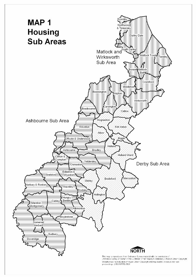
3.6 The Derby and Derbyshire Joint Structure Plan requires land for 3100 dwellings to be provided in the period 1991 – 2011. These dwellings are distributed across the sub areas as follows: (Map 1 identifies the extent of each sub area)
Ashbourne 1300
Derby 300
Matlock/Wirksworth 1500
3.7 At April 2003, 2261 dwellings had been built since 1991, 335 were under construction and a further 948 had planning permission but work had not commenced. Table 1. sets out this information on a sub area basis.
3.8 In accordance with PPG3, an urban capacity study has been undertaken for the Market Towns of Ashbourne, Matlock and Wirksworth.
3.9 These towns were selected as they have been identified in the Strategic Framework as being best placed to make a contribution to sustainable development.

15
3.10 The underlying strategy of the plan is to concentrate development within the most sustainable locations, whilst seeking to protect the countryside from inappropriate development. Consequently the purpose of the study was to identify all land with potential to be developed for housing within the main urban areas.
3.11 Table 2 below summarises the results of the urban capacity study.
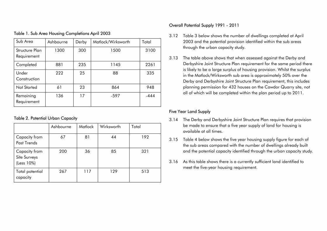
Table 1. Sub Area Housing Completions April 2003
Sub Area Ashbourne Derby Matlock/Wirksworth Total
Structure Plan Requirement
1300 300 1500 3100
Completed 881 235 1145 2261
Under Construction
222 25 88 335
Not Started 61 23 864 948
Remaining Requirement
136 17 -597 -444
Table 2. Potential Urban Capacity
Ashbourne Matlock Wirksworth Total
Capacity from Past Trends
67 81 44 192
Capacity from Site Surveys (Less 10%)
200 36 85 321
Total potential capacity
267 117 129 513
Overall Potential Supply 1991 - 2011
3.12 Table 3 below shows the number of dwellings completed at April 2003 and the potential provision identified within the sub areas through the urban capacity study.
3.13 The table above shows that when assessed against the Derby and Derbyshire Joint Structure Plan requirement for the same period there is likely to be a large surplus of housing provision. Whilst the surplus in the Matlock/Wirksworth sub area is approximately 50% over the Derby and Derbyshire Joint Structure Plan requirement, this includes planning permission for 432 houses on the Cawdor Quarry site, not all of which will be completed within the plan period up to 2011.
Five Year Land Supply
3.14 The Derby and Derbyshire Joint Structure Plan requires that provision be made to ensure that a five year supply of land for housing is available at all times.
3.15 Table 4 below shows the five year housing supply figure for each of the sub areas compared with the number of dwellings already built and the potential capacity identified through the urban capacity study.
3.16 As this table shows there is a currently sufficient land identified to meet the five-year housing requirement.
16
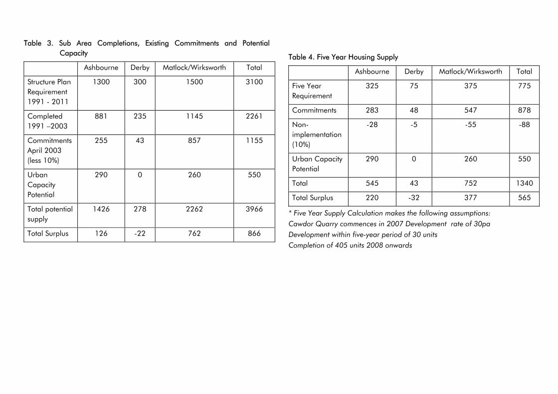
Table 3. Sub Area Completions, Existing Commitments and Potential Capacity
Ashbourne Derby Matlock/Wirksworth Total
Structure Plan Requirement 1991 - 2011
1300 300 1500 3100
Completed 1991 –2003
881 235 1145 2261
Commitments April 2003 (less 10%)
255 43 857 1155
Urban Capacity Potential
290 0 260 550
Total potential supply
1426 278 2262 3966
Total Surplus 126 -22 762 866
Table 4. Five Year Housing Supply
Ashbourne Derby Matlock/Wirksworth Total
Five Year Requirement
325 75 375 775
Commitments 283 48 547 878
Non-implementation (10%)
-28 -5 -55 -88
Urban Capacity Potential
290 0 260 550
Total 545 43 752 1340
Total Surplus 220 -32 377 565
* Five Year Supply Calculation makes the following assumptions: Cawdor Quarry commences in 2007 Development rate of 30pa Development within five-year period of 30 units Completion of 405 units 2008 onwards
17
18
3.17 The allocation of any new and additional sites for residential purposes would therefore exacerbate this situation. No land has therefore been allocated for residential development in the Local Plan for the period up to 2011. To ensure that the amount of residential development that comes forward in the period up to 2011 is generally in accordance with the Derby and Derbyshire Joint Structure Plan, the Council will continue to monitor and manage the release of housing land. This may involve refusing the renewal of existing planning permissions where they no longer meet current policy guidance.
Provision For New Housing Development
3.18 In accordance with advice in PPG3, preference will be given to residential development involving previously developed land, located within Settlement Framework Boundaries. Proposals for the redevelopment of existing employment land and/or business premises should however, have regard to the provisions of Policy EDT4.
3.19 The majority of new housing provision within the plan period will be provided through infill and consolidation and from conversions and changes of use.
3.20 Not every undeveloped site will be appropriate for development. Backland and garden development especially where it would result in an unacceptable loss of privacy and levels of amenity to both existing and proposed dwellings will not be acceptable.
3.21 Development on open space that contributes to the character, appearance, and setting of the settlement will also be resisted.
3.22 Within the Settlement Framework Boundaries infill development is defined as consisting of development of a small gap within a substantially built-up frontage in most cases of not more than two dwellings
Policy H1
New Housing Development Within Settlement Framework Boundaries
Within the Settlement Framework boundaries shown on the Proposals Map residential development will be permitted for the following:
(a) conversion of existing dwellings to provide additional units;
(b) conversion of existing buildings to housing;
(c) replacement of existing dwellings;
(d) in-filling or consolidation, especially where this makes full and effective use of previously developed land or buildings where the previous use is no longer required.
All such development must respect the character, appearance and setting of the settlement.
Extensions to Residential Properties
3.23 Extensions to houses can improve living conditions for occupiers, without the need to move. The majority of residential properties can be extended by a limited amount without the need for planning permission. Where required, planning permission will be granted for extensions to residential properties, provided it does not result in a detrimental impact upon the scale and character of the dwelling and its surroundings, or lead to adverse impact upon residential amenity of neighbouring properties. In order to both safeguard the character and appearance of the original building, and its impact upon the local and wider landscape, the Council will resist proposals to extend residential properties brought forward through the re-use or conversion of buildings outside of a Settlement Framework.
19
Policy H2
Extensions To Dwellings
Planning permission will be granted for extensions to existing dwellings, providing that;
(a) it would not result in a detrimental impact on the character and appearance of the dwelling and its surroundings and;
(b) it does not result in a significant loss of privacy or amenity for residents of neighbouring properties.
Dependent Person Units
3.24 Additional accommodation is sometimes required for dependant persons to enable them to live alongside a carer or relative. This type of accommodation will generally come forward in three forms; an extension to an existing dwelling, the conversion of suitable outbuildings, or the construction of a small independent unit.
3.25 The size and scale of a dependent person unit must not render it capable of independent occupation. Proposals of a size and scale that would render them capable of independent occupation will be considered on the basis of new residential development.
3.26 All proposals should not have an adverse impact upon the character and appearance of the dwelling, or out buildings where conversion is proposed. Proposals should not have an adverse impact upon their surroundings or the amenity of neighbouring properties.
Policy H3
Dependent Persons Units
Planning permission will be granted for dependent persons units provided that;
(a) the scale of the dependent person unit is commensurate with the needs of the dependent person and;
(b) it would not result in a detrimental impact on the character and appearance of the dwelling or buildings or group of buildings and its surroundings and;
(c) it does not result in a significant loss of privacy or amenity for residents of neighbouring properties.
The Council will impose conditions in respect of dependant persons units to ensure that they are occupied in association with the main dwelling and are not capable of independent occupation after the use ceases.
Residential Development in the Countryside.
3.27 PPS7 advises that new house building in the open countryside, away from established settlements or from areas allocated for development should be strictly controlled, and requires special justification. In order to preserve the attractive areas of open countryside surrounding the settlements, to minimise the loss of agricultural land and to avoid the high costs of servicing new development in scattered and isolated locations, applications for residential development in the countryside will therefore normally be refused.
3.28 It is recognised that some activities can only take place or are best located in the countryside. A limited number of new dwellings may be required in connection with these activities.
3.29 In order to provide affordable housing to meet local needs, small sites may be released on land that would normally be regarded as being within the countryside. These sites should however be well related to existing settlements, rather than be in isolated locations.
20
Policy H4
Housing Development Outside Settlement Framework Boundaries
Outside the Settlement Framework boundaries defined on the Proposals Map planning permission will be granted for housing that: (a) is essential for the operation of
agriculture, forestry or other enterprise that needs to be in that location; or
(b) consists of affordable housing for an identified local need.
Conversion of Buildings to Residential Development in the Countryside
3.30 The Government is committed to maximising the re-use of previously developed land and empty properties and the conversion of non-residential buildings for housing, in order both to promote regeneration and minimise the amount of greenfield land being taken for development.
3.31 However in the countryside, outside the defined Settlement Frameworks, PPS7 and the policies in the Derby and Derbyshire Joint Structure Plan give preference to the conversion and re-use of rural buildings for employment use over residential development.
3.32 Not all buildings are appropriate for conversion to a permanent open market residential use. Many are in isolated locations in the open countryside and only suitable for conversion to permanent residential accommodation for use in connection with farming or other rural activity. In the countryside some buildings, having outlived their original purpose, are better demolished and the site returned to a green field.
3.33 However, some redundant buildings are of architectural or historic interest and can make an important contribution to the character of the settlement or to the quality of the landscape. Preference is for such buildings to be retained and put
back into beneficial use rather than being allowed to fall into disrepair. Whilst employment uses are preferable, conversion to residential use may be a more appropriate means of securing their long-term preservation. In all cases Policy H4 must also be taken into account alongside Policy H5 below.
3.34 Residential conversions can often have a detrimental impact upon the fabric and character of barns, mills and other traditional buildings. Ancillary activities such as garaging, car parking, and boundary treatments can be very intrusive in the countryside. If planning permission is granted for a residential conversion the Council will seek to impose conditions removing all permitted development rights.
Policy H5
Conversion And Re-Use Of Buildings To Provide Residential
Accommodation Outside Settlement Frameworks
Outside the Settlement Frameworks defined on the Proposals Map planning permission will be granted for the conversion of existing buildings to housing from other uses, only where;
(a) the building or group of buildings are of permanent and substantial construction and;
(b) the form, bulk and general design of the existing building or group of buildings make a positive contribution to the character and appearance of its surroundings and;
(c) the building or group of buildings can be converted without extensive alteration, rebuilding or extension and;
(d) the conversion does not have a detrimental impact upon the character and appearance of the building or group of buildings and its surroundings; and
(e) the building or group of buildings are
21
not suited for conversion to employment or tourism uses.
Replacement Dwellings in the Countryside
3.35 In some instances an existing dwelling is no longer conducive to modern day living requirements or is beyond economic repair. Demolition and replacement by a new dwelling is often seen as the most appropriate option. In most cases planning permission will be granted for such proposals. Where the original dwelling is within a conservation area or is a listed building, preference will be given to the repair and/or renovation of the original dwelling over its demolition and subsequent replacement.
3.36 If the Council considers it appropriate to allow the demolition and replacement of either a dwelling within a conservation area or a listed building a high standard of design and the use of traditional materials appropriate to the location will be required.
3.37 In rural areas outside Settlement Frameworks replacement dwellings will normally be permitted only where they achieve a high standard of design, and do not have an adverse impact upon the character and appearance of the countryside. In some instances, carefully designed larger dwellings can replace smaller properties on large plots without causing a detrimental impact upon the character and appearance of the countryside. Conditions may also be imposed requiring the re-use of the existing materials.
3.38 In all cases, planning permission for a replacement dwelling will include a condition requiring the demolition of the existing dwelling to be replaced. If the dwelling to be replaced has already been demolished, the Council will consider this on the basis of a new dwelling, and not a replacement.
Policy H6
Replacement Dwellings In The Countryside
Outside the Settlement Frameworks defined on the Proposals Map planning permission will be granted for replacement dwellings provided that;
(a) the number of dwelling units is not increased and;
(b) renovation and/or repair of the original building is not a more satisfactory alternative and;
(c) the replacement dwelling and ancillary buildings do not have a detrimental impact upon the character and appearance of its surroundings;
Where planning permission is granted, the Council will impose conditions requiring the demolition of the existing dwelling and, where appropriate, the re-use of reclaimable existing materials.
New Dwellings for Agriculture, Forestry or Other Rural Enterprises
3.39 In most cases workers employed in agriculture or other rural based enterprises, and their families, will be to able live in nearby villages or towns rather than having to build new dwellings in the countryside. However, there will be some cases where it is essential for those employed in these enterprises to live at, or very close to the site of their work. Whether this is essential in any particular case will depend on the needs of the enterprise concerned and not on the personal preferences or circumstances of any individual involved.
3.40 If planning permission is to be granted, it will be an exception to normal planning policy. The onus is therefore on the applicant to satisfy the Council that their involvement in farming, forestry or other rural enterprise is genuine, (or is reasonably likely to materialise), that the
22
activity requires essential supervision necessitating a new dwelling close by and is capable of being sustained for a reasonable period of time sufficient to justify the development.
3.41 When assessing applications for dwellings associated with agriculture, forestry or other rural based enterprise the Council will apply both functional and financial tests in accordance with guidance contained in PPS7.
3.42 If planning permission is granted for a new dwelling, the Council will seek to negotiate a Section 106 Obligation with the applicant that ties the dwelling or dwellings to the holding itself.
3.43 Any development in the countryside is potentially intrusive. To minimise the impact on the landscape, preference is for the re-use and conversion of existing farm buildings, or the siting of new dwellings adjacent to an existing group of farm buildings. Where such a location is not practical the siting will need to have regard to existing features, such as farm buildings, trees, hedgerows and the contours of the land, and to servicing arrangements. An exposed site that takes little account of these factors will not be acceptable.
Policy H7
New Dwellings For Agricultural Or Forestry Workers Or Rural Based Enterprises In The Countryside
Outside the Settlement Framework boundaries defined on the Proposals Map planning permission will be granted for dwellings required for agriculture or forestry workers or in association with an activity that needs to be located in the area, provided that:
(a) no suitable accommodation exists to meet the needs of the activity on the site or in the locality nearby and the need for the dwelling is justified on functional and, where necessary, financial grounds,
which clearly demonstrate the sustainability of the activity and the requirement for on-site accommodation; and
(b) the size of the dwelling is commensurate with the needs of the activity and is sustainable in terms of the viability of activity; and
(c) it is well related to either existing dwellings or buildings associated with the activity with which it is required.
In all cases, the Council will seek to negotiate a section 106 obligation which:-
(d) will prevent the sale of the dwelling separately from the site itself or any part of it without the prior approval of the Council; and
(e) will limit occupation of the dwelling to a person solely employed in a rural based activity where on-site accommodation is justified or;
(f) to a person solely, mainly or last working in agriculture in the locality, or to a widow or widower of such persons, and to any resident dependants.
3.44 In accordance with national, regional and local policy guidance to restrict unnecessary residential development outside defined settlements, the Council will, when determining applications for planning permission, take in to consideration the circumstances surrounding the separate disposal and/or occupation of any suitable dwelling, reasonably sited for the management and supervision of an activity that needs to be located in the area, that has occurred within the preceding 5 years.
3.45 Applications to remove occupancy restrictions will be considered on the basis of an assessment of the continuing need, bearing in mind that they will relate to the need for a dwelling for anyone working in agriculture, forestry or
23
other rural enterprise in the area as a whole and not just on the particular holding or site which originally justified the provision of the dwelling.
Extending Domestic Curtilages into the Countryside
3.46 The use of agricultural land as garden land constitutes a change of use for which planning permission is required. It can have a damaging effect upon the character and appearance of the countryside. The Council will therefore generally seek to resist the extension of domestic gardens into the countryside, except where it maintains or enhances the character and appearance of the landscape.
3.47 Whenever planning permission is granted, the Council will impose conditions removing permitted development rights, and requiring the approval of a landscaping scheme that reflects the local distinctiveness, character and diversity of the landscape.
Policy H8
Extending Domestic Curtilages Into The Countryside
Planning permission to extend a domestic curtilage into open countryside will only be granted where it preserves or enhances the character and appearance of the local landscape.
Where planning permission is granted the Council will seek to impose conditions that;
(a) secure a landscaping scheme that reflects the local distinctiveness, character and diversity of the landscape and;
(b) require the owner to maintain any existing trees or hedgerows and any new planting in accordance with good horticultural and arboricultural practice and to replace any losses; and
(c) removes permitted development rights and prevents any buildings or structures being erected within the extended garden.
Design and Appearance of New Housing
3.48 PPG3 envisages new housing development improving the quality and attractiveness of residential areas. The following policy seeks to achieve a high quality of housing design. Advice in PPG3, is that new housing development should be provided at a minimum density of 30 dwellings per hectare, unless it can be shown that this would be inappropriate having regard to the scale and character of the locality. In locations where there is good access to public transport or where services and facilities are within easy walking or cycling distance, such as within or adjoining town centres, or around major nodes along public transport corridors, higher densities may be more appropriate.
Policy H9
Design And Appearance Of New Housing
Planning permission will only be granted for new housing development where;
(a) it is in scale and character with its surroundings and;
(b) it has regard to distinctive landscape features and provides supplementary landscaping where appropriate and;
(c) adequate amenity space is available for each dwelling unit and;
(d) reasonable privacy for each dwelling is provided and;
(e) it does not have a detrimental impact upon the amenities of adjoining or adjacent properties, and;
(f) it does not consist of development within the curtilage of a dwelling or on a site
24
where access cannot be provided independently unless adequate privacy and amenity for both the proposed and existing dwellings can be provided.
Affordable Housing
3.49 In Derbyshire Dales, local people are facing increasing difficulty in being able to afford suitable housing. The problem stems from a combination of factors;
• an environment attractive to the wealthy, to commuters from nearby cities and to those seeking retirement or holiday accommodation which increases competition and leads to inflated house prices;
• lower incomes compared to those received in the larger urban areas;
• a decreasing stock of Local Authority rented accommodation
3.50 Planning Policy Guidance Note 3: Housing (March 1992), and Circular 06/98 'Planning and Affordable Housing' (April 1998), sets out the Government's preferred approach to the provision of affordable housing through the planning system.
3.51 Circular 06/98 sets out that, where there is a demonstrable lack of affordable housing to meet local needs based on up-to-date surveys and other data of local need, Local Planning Authorities should include in the Local Plan a policy for seeking an element of affordable housing on suitable sites. The policy should;
a) Define what they regard as affordable housing.
b) Indicate how many affordable homes need to be provided throughout the plan area.
c) Set indicative targets for specific suitable sites (either as a number or
a percentage of the homes on the site).
d) Indicate an intention to negotiate with developers for the inclusion of an element of affordable housing on suitable sites.
Definition of Affordable Housing
3.52 Circular 06/98 sets out that affordable housing should encompass both low cost market and subsidised housing, (irrespective of tenure or financial arrangements), which is available to people who cannot afford to rent or buy houses generally available on the open market. For the purposes of clarity, the following definition is considered appropriate for affordable housing in Derbyshire Dales.
"Affordable Housing encompasses both low-cost market and subsidised housing (irrespective of tenure, ownership - whether exclusive or shared or financial arrangements) that will be available to people who cannot afford to rent or buy houses generally available on the open market"
Assessing Needs
3.53 In order to obtain an objective assessment of the housing needs of the residents of the District, a housing needs survey was undertaken in October 2001. The survey assessed the general characteristics of households across the whole District, housing need for the whole District, and affordability in the housing market, taking into account house prices, rental and income levels. The outcome of the survey will be used in the preparation of the Council's Housing Strategy and in support of its Housing Investment Programme.
3.54 On the basis of the Housing Needs Survey, and current local housing market conditions, 998 dwellings are required to

25
be provided as affordable housing for the period 2002-2011 within the Local Plan Area. This represents, as at April 2002, approximately 63% of the total identified supply of land for housing across the plan area. The distribution of the requirements for affordable housing is set out in Table 5 below;
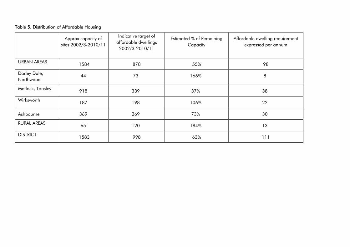
Table 5. Distribution of Affordable Housing
Approx capacity of sites 2002/3-2010/11
Indicative target of affordable dwellings
2002/3-2010/11
Estimated % of Remaining Capacity
Affordable dwelling requirement expressed per annum
URBAN AREAS 1584 878 55% 98
Darley Dale, Northwood
44 73 166% 8
Matlock, Tansley 918 339 37% 38
Wirksworth 187 198 106% 22
Ashbourne 369 269 73% 30
RURAL AREAS 65 120 184% 13
DISTRICT 1583 998 63% 111
26
27
3.55 The precise arrangements for the provision of on-site affordable housing will be determined at the time a site becomes available and will be dependent upon the level of need for affordable housing, site suitability, the economics of developing each site, the proximity of local services, and access to public transport.
3.56 The Council considers that setting a requirement that approximately 60% of all new dwellings on sites above the threshold be provided as affordable housing could be counter productive, and likely to fail to deliver any affordable housing in the plan area. Furthermore the restriction imposed on the supply of new houses as a result could inflate house prices further, thereby putting more in need of affordable housing than at present. As a general rule, therefore, the Council will seek to negotiate within the urban areas a minimum provision of 45% of all new dwellings as affordable housing.
Policy H10
Affordable Housing Within The Settlement Framework Of Market
Towns
In determining applications for residential development within the Settlement Frameworks shown on the Proposals Map of the defined Market Towns the Council will seek to negotiate the provision of 45% of all dwellings as affordable housing on allocated sites and sites of 0.5 hectares and above, or where the number of dwellings proposed is 15 or more.
In assessing the suitability of a site for providing affordable housing the Council will take account of the economics of developing the site, the proximity of local services, and access to public transport.
3.57 Circular 06/98 sets out that in settlements in rural areas with a population of 3,000 or fewer, Local Planning Authorities should adopt appropriate thresholds. The Council’s Housing Needs Survey has indicated that in rural areas it is appropriate to apply a threshold of 2 or more dwellings or 0.1ha site size above which the Council should seek to negotiate for the provision of affordable housing.
3.58 If this threshold were strictly applied, the Council would be seeking to negotiate the provision of affordable housing on a number of residential developments in isolated locations. These would make little or no contribution to the achievement of sustainable development, and potentially could have a detrimental impact upon the character and appearance of the countryside. The Council will therefore only seek to negotiate the on site provision of affordable housing in connection with open market housing within the Settlement Frameworks of the Other Settlements. The Council will seek to negotiate the on-site provision in respect of both new build housing and conversions and changes of use.
Policy H11
Affordable Housing Within The Settlement Frameworks Of Other
Settlements
In determining applications for planning permission for residential development within the Settlement Framework boundaries of the Other Settlements defined on the Proposals Map the Council will seek to negotiate the provision of 33% of all dwellings as affordable dwellings on sites of 0.1 hectare or more and/or capable of accommodating 2 or more dwellings.
28
3.59 Where residential development is granted planning permission outside the Settlement Frameworks of Other Settlements, in order to address the level of need for affordable housing in the rural areas, and in order to maximise the delivery of affordable housing, the Council will seek to negotiate a financial or other contribution towards the provision of affordable housing.
Policy H12
Alternative Provision For Affordable Housing Outside Settlement
Frameworks
In determining applications for residential development outside defined Settlement Frameworks, the Council will seek to negotiate a financial or other contribution towards the provision of affordable housing on suitable sites elsewhere in the plan area.
Dwelling Type and Mix
3.60 It is important to ensure that the type of dwellings to be provided as affordable housing meets local needs. The Council’s Housing Needs Survey has indicated that the majority of need is for one and two bedroom accommodation in the form of flats, terraces and semi-detached houses. Where affordable housing is to be provided on-site, the Council will ensure that there is an appropriate mix of dwellings, type and size, to meet these needs.
Occupancy
3.61 The Council will also ensure that where affordable housing is built its benefits pass in perpetuity to those people for whom it is most needed. The Council's priority is to ensure that affordable housing is provided for those households in housing need. The Council's preferred approach for controlling the occupancy
of any affordable housing provided will be for its management to be undertaken by a registered social landlord, such as a Housing Association or through a shared ownership scheme.
Alternative Provision of Affordable Housing
3.62 Where it is considered not appropriate to provide any requirement for affordable housing on the development site itself within a Settlement Framework Boundary, the Council may seek to negotiate, in lieu of on-site provision of affordable housing, a financial or other contribution towards the provision of affordable housing elsewhere in the area. Such a contribution will not, however be sought for sites which come forward for development below the thresholds set out in Policies H10, and H11 above.
Affordable Housing: Exceptional Sites in Rural Areas
3.63 Within the rural areas not covered by Policy H10, planning policies have consistently sought to restrict housing development. Exceptions to these policies to provide affordable housing for local needs will only be made in very special circumstances. The implementation of an affordable housing scheme under the rural 'exception' policy will be treated as additional to the stipulated housing provision of the Local Plan. Each of these schemes will be satisfying an identified and recognised local need. Where such a pressing local need is shown to exist development will be expected to take place within or on the edge of the Settlement Framework and pay due regard to normal development control considerations including, access, design, layout and impact upon the highway network and the character of the area. It is considered that small sites capable of accommodating a very limited number of
29
dwellings are generally capable of meeting established local needs.
3.64 Whilst most local needs housing in the rural areas is likely to be located on sites which would not normally receive planning permission for open market housing, the Council still has a responsibility to ensure that developments would not be detrimental to the character or amenity of the area. A well conceived local needs housing scheme, appropriately located, will not only benefit from available village services, but will itself help to sustain village schools, shops, pubs, places of worship and other valued community facilities. Consequently rural exception housing sites will only be permitted within or immediately adjoining a settlement with a Settlement Framework. Isolated locations will not be acceptable.
3.65 The onus rests entirely on the promoter of a 'local need' scheme to establish the exceptional circumstances that may justify the release of a site. The Council, will need to be persuaded that the proposed scheme meets a local housing need to the benefit of the community. A comprehensive survey of local housing needs will be required to demonstrate to the Council that the need is a community need and not an individual need. The proposed scheme must also demonstrate that it meets the individual requirements identified in terms of design, size, type and tenure of dwelling. A case based on the existence of unmet demand is unlikely to satisfy the Council that a genuine need exists.
Definition of Local Need
3.66 The following groups of people will normally be considered to come within the definition of “local need" for the purposes of assessing planning applications and submitted schemes in rural areas.
a) People residing continuously for a period of not less than five years out of the previous ten years in the parish or adjoining parishes and currently living in accommodation that is overcrowded or otherwise unsatisfactory.
b) People residing continuously for a period of not less than five years out of the previous ten years in the parish or adjoining parishes and forming a household for the first time.
c) People who are related to a resident of the parish or are not now resident in the parish but who have resided continuously within the parish or adjoining parishes for more than ten years out of the previous twenty.
d) People who have an essential need arising from age or disability to live close to other people who have lived continuously within the parish or adjoining parishes for more than five years out of the previous ten.
e) People who have an essential need to live close to their work in the parish or adjoining parishes.
Policy H13
Affordable Housing Exceptional Sites In Rural Areas
As an exception to normal planning policies applying throughout the area, the Council will grant planning permission for affordable housing on sites that would not normally be released for housing development, provided that:
(a) it would meet a genuine local need as defined in paragraph 3.66 above that would not otherwise be met;
(b) there are arrangements made to ensure that the benefits remain in perpetuity for local people who cannot afford to
30
occupy houses generally available on the open market;
(c) it is of a size, type, occupancy, and cost suitable to meet the identified local needs; and
(d) it takes full account of environmental considerations as set out in policies elsewhere in the local plan. Sites should be located within or adjoining the built up areas of settlements.
Proposals will only be permitted where the detailed siting, scale, design, use of colour, materials and landscape treatment do not have an adverse impact upon the character and appearance of the area.
Special Needs Housing
3.67 One of the Government’s objectives is that local authorities should plan to meet the housing requirements of the whole community, including those in need of affordable and special needs housing. The Council has invested its resources into the provision of housing adaptations to meet the needs of those people with disabilities. New housing can easily be designed from the outset to be suitable for adaptation to meet the needs of the elderly or those with disabilities. The Council will therefore seek to negotiate on suitable housing schemes the provision of special needs housing.
Policy H14
Housing To Meet The Needs Of The Elderly And People With Disabilities
Where planning permission is granted for housing on sites on level ground within 300m reasonably level travelling distance of shops, transport facilities and other community services, the Council will seek to negotiate a proportion of dwellings which would be accessible to persons in wheelchairs or with restricted mobility.
Residential Accommodation for Gypsies
3.68 Government guidance in Circular 1/94 stresses that it is important for Local Plans to contain policies relating to the provision of sites for gypsies. The provision of sites should be consistent with the protection of the character of the countryside, landscape and nature conservation interests. Sites should be well related to the pattern of service provision including shops, schools and other community facilities. Sites for Gypsies can vary in size from small family sites, accommodating few caravans, to large sites with many caravans plus associated business activities and vehicles. The significance of each criterion in policy H15 may, therefore, vary for individual proposals.
Policy H15
Accommodation For Gypsies
Planning permission for gypsy sites will be granted provided that the site:
(a) is close to the road network, with good access to and from it, and public transport services, and
(b) is within reasonable travelling distance of local services and facilities, and
(c) will be provided with a reasonable level of services, including water, electricity and sewage disposal, and
(d) will be well drained and able to accommodate flat areas of hard-standings suitable for caravans and other associated vehicles, and
(e) where necessary is able to incorporate a separate area or areas where business activities can be carried out without harm to the living conditions of nearby occupiers or to the environment generally, and
(f) will provide an acceptable standard of living conditions for its residents, and

31
(g) where necessary is sufficiently distant from established residential areas to avoid harm to living conditions arising from noise and other disturbance due to the movement of vehicles to, from and within the site, and
(h) does not cause harm to the character and appearance of the area.

32

CHAPTER 4
Economic Development & Tourism
Objectives • to establish and allocate land required
for employment purposes in the period up to 2011
• to facilitate quality employment opportunities in locations that contribute to the achievement of sustainable development, and minimise the need to travel by motor vehicle
• to encourage a high standard of design and layout for buildings required for employment purposes
• to balance the needs of the tourism industry with the need to safeguard the environment
• to create an environment conducive to encouraging farm diversification within the countryside
Introduction
4.1 One of the Government's key objectives is to encourage continued economic development and growth. PPG12 advises that in preparing development plans, local authorities should take account of the need to revitalise and broaden the local economy, the need to stimulate employment opportunities, and the importance of encouraging industrial and commercial development, particularly in the growing knowledge driven sector. Local authorities are advised to provide a range of suitable sites in their plans for industrial and commercial development that take account of the needs of existing and future businesses.
4.2 PPG4 advises that development plans offer the opportunity to:
• encourage new development in locations which minimise the length and number of trips, especially by motor vehicles;
• encourage new development in locations that can be served by more energy efficient modes of transport;
• discourage new development where it would be likely to add unacceptably to congestion;
• locate development requiring access mainly to local roads away from trunk roads, to avoid unnecessary congestion on roads designed for longer distance movement.
4.3 PPS7 sets out that many commercial and light manufacturing activities can be carried on in rural areas without causing unacceptable disturbance. A countryside environment attracts many firms, and there are benefits to the local economy and employment. PPS7 indicates that these firms can bring new life and activity to rural communities, as well as contribute to both local and national competitiveness.
4.4 PPG21 advises that the planning system should facilitate and encourage development and improvement in tourist provision, while tackling any adverse effects of existing tourist attractions and activity in a constructive and positive manner.
4.5 The Council’s Economic Development Strategy seeks to retain existing jobs in the area and to create additional employment opportunities through the expansion of existing businesses, the development of new ventures and the attraction of business and investment into the area.
Derby and Derbyshire Joint Structure Plan
4.6 The Derby and Derbyshire Joint Structure Plan, adopted in January 2001, sets out
33
strategic economic development and tourism policies in the context of national and regional guidance.
4.7 The policies in the Derby and Derbyshire Joint Structure Plan;
• Set out the total provision for business, general industrial and distribution use between 1991 and 2011.
• Limit the loss of business, general industrial and distribution land and buildings, except where such uses are incompatible with existing adjacent uses.
• Seek to balance employment and housing provision in order to reduce the need to travel.
• Promote the re-use of derelict, despoiled, unused and under-used land.
• Favour developments that use spare capacity in existing infrastructure, including public transport.
• Control developments that would have unacceptable adverse environmental effects.
• Encourage the expansion or relocation of existing business, general industrial and distribution uses within the same general area.
• Encourage the development of small-scale business and distribution, including, where appropriate, within primarily residential and rural areas.
• Retain the flexibility to accommodate major business or general industrial users on key employment sites, subject to appropriate criteria.
• Consider proposals for major distribution facilities against a number of criteria, including accessibility, traffic generation and environmental impact.
• Promote the location of major new office and institutional developments within the urban areas.
• Provide development sites following the reclamation of former opencast and other mineral workings.
Land For Industrial Development
4.8 The Derby and Derbyshire Joint Structure Plan requires that provision be made for 35 hectares of land for business, general industrial and distribution development in the period 1991 and 2011. This provision to be distributed across sub areas as follows (Map 1 identifies the extent of each sub area);
Ashbourne 15ha
Matlock/Wirksworth 20ha
4.9 From April 1991 to March 2003 3.71 hectares of employment land had been developed, 1.87 hectares in the Ashbourne sub area and 1.84 hectares in the Matlock/Wirksworth sub area. A further 3.17 hectares of land had the benefit of planning permission for employment development. The breakdown of land developed is shown in Table 6.
34
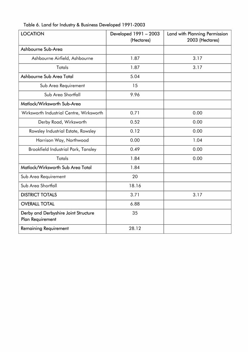
Table 6. Land for Industry & Business Developed 1991-2003
LOCATION Developed 1991 – 2003 (Hectares)
Land with Planning Permission 2003 (Hectares)
Ashbourne Sub-Area
Ashbourne Airfield, Ashbourne 1.87 3.17
Totals 1.87 3.17
Ashbourne Sub Area Total 5.04
Sub Area Requirement 15
Sub Area Shortfall 9.96
Matlock/Wirksworth Sub-Area
Wirksworth Industrial Centre, Wirksworth 0.71 0.00
Derby Road, Wirksworth 0.52 0.00
Rowsley Industrial Estate, Rowsley 0.12 0.00
Harrison Way, Northwood 0.00 1.04
Brookfield Industrial Park, Tansley 0.49 0.00
Totals 1.84 0.00
Matlock/Wirksworth Sub Area Total 1.84
Sub Area Requirement 20
Sub Area Shortfall 18.16
DISTRICT TOTALS 3.71 3.17
OVERALL TOTAL 6.88
Derby and Derbyshire Joint Structure Plan Requirement
35
Remaining Requirement 28.12
35
4.10 In order to meet the requirements of the Derby and Derbyshire Joint Structure Plan there is consequently a need to identify in the Local Plan approximately 28.12 hectares of employment land.
4.11 To ensure that any land allocated in the Local Plan contributes to the Council’s overall aims and objectives as set out in the Economic Development Strategy the emerging Sub- Regional Strategic Partnership, and the advice in PPG4, the location of new land for employment needs to contribute towards the achievement of sustainable development, and have a realistic prospect of being developed.
4.12 While the existing and allocated employment sites are intended primarily to accommodate uses within Classes B1, B2 and B8 other activities may be acceptable, such as vehicle repair and sales, business support services, hotels, fitness centres, offices that cannot be accommodated within or adjacent to town centres and activities ancillary to the businesses located on the site.
4.13 Taking all these factors into consideration the following sites are allocated for employment development in the Local Plan:
(i) Hall Dale Quarry, Matlock (12 Ha)
This is a disused quarry approximately 1 km to the south west of Matlock town centre. It has a gross area of about 27 Ha, although only about 12 Ha of the site are capable of being developed for industrial and business uses. The site is immediately adjacent to the site granted permission for residential development at Cawdor Quarry. The location, topography and landscape features of the site mean that it will have only a limited impact upon the character and appearance
of the area. Any development within the site will make a considerable contribution to the achievement of sustainable development in Matlock. It is suitable for a wide variety of uses including high technology, creative industries, and managed workspaces. To ensure that the development of the site does not have a detrimental impact on the residents of the settlements of Oker, Snitterton, Winster, Wensley and Darley Bridge preference is for access into and out of the site to be solely from the east only. It would however be necessary for this to be confirmed as an appropriate course of action by the submission of a transport assessment.
(ii) Harveydale Quarry, Matlock (1 Ha)
This is a disused quarry adjoining the A6 on the edge of the town centre of Matlock. Part has previously been in use as a lorry park. The land was formerly owned and used by the Tarmac Group. The remainder is secluded from view and largely disused. The Highway Authority advises that the existing access is unsuitable for use by heavy goods vehicles. There may be rock face instability problems to be overcome prior to any development taking place.
(iii) Land off Middleton Road, Wirksworth (9.1 Ha)
This is an area of previously developed land to the rear of the Ravenstor Industrial Estate and extends across to Middleton Road. This site was previously allocated for employment use in the Derbyshire Dales Local Plan (1998).
(iv) Ashbourne Industrial Estate Extension (9.5 Ha)
36
This area of land represents a logical extension to the existing Ashbourne Industrial Estate. It also offers the opportunity to resolve long-standing un-neighbourly problems created by the presence of a very large, 2nd World War aircraft hangar which adjoins residential property. This hangar is in the same ownership as the majority of the site and, to be acceptable to the Council, a scheme involving the creation of a substantial landscaped buffer between residential property and industrial uses is required.
(v) Clifton Road, Ashbourne (1.86 Ha)
Derbyshire Dales District Council owns this area of land. It is situated immediately adjacent to the access to Ashbourne Leisure Centre. The site has the potential to be brought forward as a mixed-use development. To reflect its sensitive location the Council will seek to achieve a high quality design and layout for the development of the site. Development of the site should not prejudice the route of the Pennine Cycleway, as it crosses the site and access to the river gauging station shall be maintained.
(vi) Harrison Way, Northwood (1.0 Ha)
This site is situated with immediate access off the A6 at Northwood. As such it is well related to the transport network, and is a sustainable location. The site is immediately available without any significant need for remediation works. Development may be affected by the line of the proposed extension of the Peak Rail to Bakewell.
(vii) Porter Lane / Cromford Road (0.2ha)
This area of land is adjacent to an existing employment site and is available to facilitate the relocation of
an existing business from Millers Green, Wirksworth
4.14 Table 7 below indicates that taking account of the sites allocated for employment use, the overall provision for employment land is slightly in excess of the requirements of the Derby and Derbyshire Joint Structure Plan at 42.08 hectares.
37
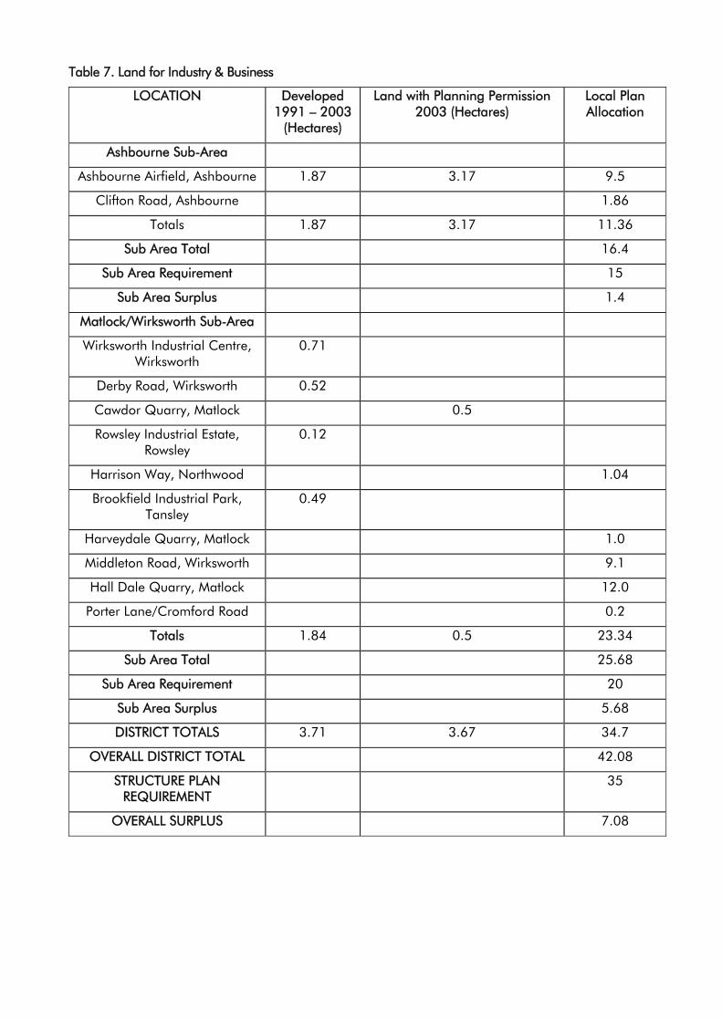
Table 7. Land for Industry & Business
LOCATION Developed 1991 – 2003
(Hectares)
Land with Planning Permission 2003 (Hectares)
Local Plan Allocation
Ashbourne Sub-Area
Ashbourne Airfield, Ashbourne 1.87 3.17 9.5
Clifton Road, Ashbourne 1.86
Totals 1.87 3.17 11.36
Sub Area Total 16.4
Sub Area Requirement 15
Sub Area Surplus 1.4
Matlock/Wirksworth Sub-Area
Wirksworth Industrial Centre, Wirksworth
0.71
Derby Road, Wirksworth 0.52
Cawdor Quarry, Matlock 0.5
Rowsley Industrial Estate, Rowsley
0.12
Harrison Way, Northwood 1.04
Brookfield Industrial Park, Tansley
0.49
Harveydale Quarry, Matlock 1.0
Middleton Road, Wirksworth 9.1
Hall Dale Quarry, Matlock 12.0
Porter Lane/Cromford Road 0.2
Totals 1.84 0.5 23.34
Sub Area Total 25.68
Sub Area Requirement 20
Sub Area Surplus 5.68
DISTRICT TOTALS 3.71 3.67 34.7
OVERALL DISTRICT TOTAL 42.08
STRUCTURE PLAN REQUIREMENT
35
OVERALL SURPLUS 7.08
38
Policy EDT1
Land For General Industrial And Business Development
Planning permission will be granted for industrial and business development on the following sites identified on the Proposals Map;
(a) Hall Dale Quarry, Matlock
(b) Harveydale Quarry, Matlock
(c) Middleton Road, Wirksworth
(d) Ashbourne Industrial Estate
(e) Clifton Road, Ashbourne
(f) Harrison Way, Northwood
(g) Porter Lane/Cromford Road
Existing Employment Land
4.15 The new industrial land allocations in this plan have been made on the assumption that the majority of land currently in industrial/business use will continue to provide employment opportunities. There are number of existing sites in industrial/business use that make a significant contribution to the achievement of sustainable development across the District by virtue of their location within or adjacent to the Market Towns and Other Settlements. On these sites the Council will support the continuation of existing, and the development of new employment opportunities. It will seek to resist the loss of part or all of these sites to other forms of development. The following existing strategic sites are identified on the Proposals Map;
• Clifton Road, Ashbourne (Nestle)
• Ashbourne Airfield, Ashbourne
• Henmore Trading Estate, Ashbourne
• Brookfield Park, Tansley
• Lime Tree Business Park, Matlock
• Bakewell Road, Matlock (Twigg’s Fabricators)
• Dale Road North, Darley Dale (Firth Rixon)
• Whitworth Road, Darley Dale (Molyneux Engineering)
• Unity Garage, Darley Dale
• Church Road, Darley Dale (Cobb Slater)
• Station Yard, Rowsley
• Peak Village, Rowsley
• Ravenstor Road, Wirksworth
• Kingsfield Industrial Estate, Wirksworth
Policy EDT2
Existing Strategic Employment Land And Business Premises
Within the existing Strategic Employment Areas as defined on the Proposals Map planning permission will be granted for industrial and business development
Within the existing Strategic Employment Areas as defined on the Proposals Map planning permission will not be granted for development that would result in the loss of any land or buildings from industrial and business use.
4.16 The Nestlé complex, closed in Autumn 2003. The site was developed as a bespoke operation to meet the productivity demands of the company,
39
and as such is unlikely to be re-used in it’s current configuration
4.17 The closure of Nestlé therefore provides a unique opportunity for the redevelopment of the site for alternative forms of employment generating uses. The Council considers that a holistic view should be taken of the redevelopment opportunities that exist, and that the adjacent land on Clifton Road, identified under Policy EDT1(e), should be incorporated into any proposals.
4.18 The combination of these two sites provides an opportunity for a genuine mixed use redevelopment scheme incorporating high quality employment generating uses, leisure uses with an element of small scale residential with the emphasis upon affordable housing.
4.19 The development of either of these sites should not be undertaken on a piecemeal basis but should follow a clearly defined development framework with the emphasis upon a high standard of design to reflect the sites location as a gateway into Ashbourne. A development brief has therefore been prepared to guide the redevelopment of these sites.
Policy EDT3
Redevelopment Of Land At Clifton Road Ashbourne
Planning permission will only be granted for the redevelopment of the land identified on the Proposals Map for a genuine mixed use development incorporating high quality employment generating uses.
4.20 Predominantly for historic reasons, not all sites currently in employment use are in appropriate locations. Many are located in close proximity, or
surrounded by residential properties, and have an adverse impact upon the residential amenity of those living nearby. The relocation to more suitable premises, and redevelopment of these sites for other uses can often improve the quality of life for those living nearby. There are, however, a number of other sites in employment use or whose last use was employment, that are located in unsustainable locations whose redevelopment to any other use would run contrary to the objectives of achieving sustainable development. In assessing proposals to redevelop existing or former employment sites the Council will give careful consideration to the need to retain and the suitability of the site for employment purposes, against any benefits that may arise.
Policy EDT4
Other Existing Employment Land And Business Premises
Planning permission will only be granted for the redevelopment or change of use of existing business or industrial land or premises for non-employment uses where;
(a) the continuation of the land or premises in industrial or business use is no longer required or;
(b) the current use is incompatible with the surrounding properties and land uses.
New Industrial and Business Developments within Settlement Frameworks
4.21 The establishment and growth of new and existing firms is vital to the local economy. Indeed the Council’s Economic Development Strategy encourages the growth and development of new and existing firms.
40
Many small firms initially operate from home, and as they grow they often require larger, more suitable premises. These can often operate within the defined Settlement Frameworks without having an adverse impact on the amenity of the surrounding properties and land uses. The Council will however resist proposals that are likely to have an adverse impact upon the surrounding area.
Policy EDT5
Industrial And Business Development Within Settlement Frameworks
Within the defined Settlement Frameworks planning permission will be granted for industrial and business development provided that the development does not have a detrimental impact upon the character and appearance of its surroundings.
The Council will impose conditions or seek to negotiate a Section 106 Obligation to ensure the development does not have a detrimental impact upon the character and appearance of its surroundings.
4.22 There are many buildings (including upper floors of shops) within the Settlements Frameworks of Market Town and Other Settlements which have become redundant or where the current use is inappropriate. The conversion of these buildings to industrial and business use can be valuable source of premises, especially for smaller firms. The conversion to industrial or business use will generally be acceptable providing that it does not have a detrimental impact upon the amenity of the area.
Policy EDT6
Conversion And Re-Use Of Buildings For Industrial And Business
Development Within Settlement Frameworks
Within the Settlement Frameworks defined on the Proposals Map, planning permission will be granted for the conversion of existing buildings to industrial and business development from other uses, where;
(a) the form, bulk and general design after conversion, alteration and or extension is in keeping with its surroundings and the wider landscape, and does not have a detrimental impact upon the, character and appearance of the building or group of buildings.
Expansion of Existing Industrial and Business Land and Premises
4.23 The growth of existing firms is essential to the local economy. Planning permission will therefore be granted for the expansion of existing firms provided the existing business is operating in an acceptable location, and the proposed expansion would not have an adverse impact on the locality.
Policy EDT7
Extension And Expansion Of Existing Industrial And Business Land And
Premises
Planning permission will be granted for expansion and extension of existing industrial and business land and premises provided that;
(a) the development would not have an adverse impact upon the character and appearance of its surrounding and;
41
(b) the development would not cause an over development of the site and;
(c) it does not create unacceptable problems in terms of the relationship between the proposal and the neighbouring uses beyond the development site.
Planning permission will be granted for the extension of buildings in industrial or business use only where the extension would not result in a detrimental impact on the character and appearance of the original building.
Design and Appearance of Industrial and Business Premises
4.24 An attractive, high quality working environment in which businesses will wish to locate, is important to the competitiveness of the local economy. Furthermore in an area such as Derbyshire Dales the design and appearance of business and industrial premises can enhance the overall quality of the environment. The Council will therefore seek to ensure that all new industrial and business premises achieve a high standard of design, layout and appearance. Attention will be paid to the overall layout, design and density of development, the materials of construction, and landscaping. Care will also be taken to ensure that new industrial or business premises do not have an adverse impact upon their setting in the local landscape.
Policy EDT8
Design And Appearance Of New Industrial And Business Premises
Planning permission will only be granted for new industrial and business premises, and extensions to existing industrial and business premises where;
(a) the design and appearance is in scale and character with its surroundings and the immediate or wider landscape and;
(b) it has regard to distinctive landscape features and provides supplementary landscaping where appropriate and;
(c) it does not create unacceptable problems in terms of the relationship between the proposal and the neighbouring uses beyond the development site.
The Employment Needs Of People With Disabilities
4.25 People with disabilities need accessible employment opportunities and a satisfactory working environment. The Council will seek to improve the working environment for people with disabilities, and will require prospective employers to have regard to their needs in the design and layout of industrial and business premises.
Policy EDT9
Provision For People With Disabilities In Schemes For Employment Purposes
Planning permission will only be granted for the development of new industrial and business premises or the extension to existing industrial premises where regard has been given to the needs of people with disabilities in
42
the design and layout of the proposed buildings including, where appropriate, access and parking arrangements.
Hazardous Or Pollutant Industries
4.26 Installations handling hazardous or potentially polluting substances require stringent control to minimise the risk of major accidents and their impact on man and the environment. PPG12 advises that in preparing or amending development plans, local authorities should include a policy or policies relating to the location of establishments where hazardous substances are used or stored, and to the development of land within the vicinity of establishments where hazardous substances are present. The Health and Safety Executive will be consulted for advice upon all relevant applications. Developments involving potentially hazardous or polluting substances are unlikely to be acceptable close to the main centres of population or in more isolated rural areas.
Policy EDT10
Industrial Development Involving Hazardous Or Pollutant Substances
Planning permission for any industrial development involving potentially hazardous or pollutant substances will only be permitted where;
(a) it would not have an adverse impact upon the character and appearance of its surroundings and;
(b) it would not have an adverse impact upon the local environment by virtue of water, noise, air or light pollution and;
(c) does not create unacceptable problems in terms of the relationship between the
proposal and the neighbouring uses beyond the development site.
Retail Uses Within Employment Areas
4.27 Retail operations ancillary to the main industrial or business use do not normally require planning permission. Large scale retail operations have the potential to undermine the vitality and viability of town centres. Except for a limited number of specialist retailing activities, which by their nature would be difficult to accommodate within the established main shopping centres, planning permission will not be granted for retail uses on employment areas and sites.
Policy EDT11
Retail Uses Within Employment Areas
Within employment areas planning permission will only be granted for retail development where;
(a) it involves a specialist retail use unsuited to a town or edge of centre location or;
(b) it would specifically serve the needs of those employed within the existing employment areas; and
(c) it does not create unacceptable problems in terms of its relationship to neighbouring uses within or beyond the employment area.
Haulage
4.28 Haulage is a significant employer in Derbyshire Dales, much of it associated with the minerals industry. In order to safeguard amenity in residential areas from the noise and disturbance caused by haulage operations they should be located well away from them. Generally
43
the most appropriate location for haulage operations will be on industrial sites or other well-screened brownfield sites, such as disused quarries. However the establishment of haulage operations in the open countryside will generally be unacceptable because of the impact on the landscape and the inherent difficulties of the rural road network. The Council will resist the expansion of haulage businesses operating from unsatisfactory but long established premises. In appropriate circumstances, the Council will either impose relevant conditions or seek to negotiate a Section 106 Obligation restricting hours of operation and lorry routing.
Policy EDT12
Haulage Operations
Planning permission will be granted for proposals to establish, relocate or extend haulage operations provided that;
(a) the proposal would not result in an adverse impact on the character and appearance of its surroundings, and the immediate or wider landscape and;
(b) the site can be effectively screened at all times from all residential properties and public vantage points.
Wherever necessary the Council will impose conditions or seek to negotiate a Section 106 Obligation to limit hours of operation and ensure that lorry routes avoid residential areas and unsuitable roads.
Development Associated with Agriculture, Forestry or Other Rural Based Enterprises
4.29 The Town and Country Planning (General Permitted Development) Order 1995 grants planning permission for certain agricultural and forestry
developments. These "permitted development rights" mean that planning permission is not needed if a development falls within one of the categories set out in the General Permitted Development Order and meets all the conditions laid down.
4.30 Developments that are not covered by agricultural and forestry permitted development rights require planning permission in the usual way. PPS7 advises that local planning authorities should include policies in their development plans for considering planning applications for agricultural development, including farm buildings and structures and agricultural dwellings.
4.31 Where new farm buildings would have a significant adverse effect upon the landscape, the Council will resist the replacement of serviceable existing farm buildings by new ones.
4.32 There are other businesses, such as boarding kennels, and equestrian centres that are generally acceptable in the countryside. However, since they often require the erection of additional buildings, such as kennels and stable blocks, in considering such proposals the Council will seek to ensure that they are of a design and scale appropriate to their rural surroundings, and that they do not have an adverse impact on the landscape. In assessing proposals for the establishment of new rural based enterprises preference will be given to schemes that involve re-use of existing buildings, rather than the construction of purpose built units. Before planning permission is granted for purpose built units, applicants will be required to demonstrate that there are no other more suitable existing buildings in the locality that are capable of being used for the proposed rural enterprise. In appropriate
44
cases, where planning permission is granted, the Council will impose conditions requiring the removal of buildings or group of buildings and the restoration of sites to its former condition.
Policy EDT13
Buildings Associated With Agriculture,
Forestry Or Other Rural Based Enterprise
Planning permission will be granted for buildings associated with agriculture, forestry or other rural based enterprise provided that;
(a) the building or group of buildings are required to support the agricultural, forestry or other rural based enterprise on the site and;
(b) the size of the building or group of buildings is commensurate with the needs of the agricultural, forestry or other rural based enterprise and;
(c) the design and external appearance of the building or group of buildings is commensurate with its function and the needs of the agricultural, forestry or other rural based enterprise and;
(d) the building or group of buildings do not have an adverse impact upon the character and appearance of the immediate or wider landscape and;
(e) are well related to existing buildings associated with the activity with which it is required.
Diversifying the Rural Economy
4.33 Farming continues to make a significant contribution to the economy of rural areas but increasingly, diversification into non-agricultural activities is vital to the continuing viability of many farm
businesses. PPS7 is supportive of well-conceived farm diversification schemes for business purposes that are consistent in scale with their rural location.
4.34 It is usually preferable for farm diversification schemes to re-use good quality existing buildings and put them to a new business use, rather than build new buildings in the countryside. New buildings, either to replace existing buildings or to accommodate expansion of enterprises, may be acceptable provided that they satisfy sustainable development objectives and are of a design and scale appropriate to their rural surroundings.
Policy EDT14
Farm Diversification
Planning permission will be granted for proposals to diversify the operation of an existing agricultural operation provided that;
(a) it makes full and effective use of existing on-holding buildings in preference to the construction of new buildings and;
(b) it does not have an adverse impact upon the character and appearance of the immediate or wider landscape.
Planning permission will only be granted for proposals involving the use of existing buildings if their form, bulk and general design are in keeping with the character and appearance of its surroundings and the proposal does not result in a detrimental impact on the character and appearance of the buildings.
Industrial and Business Development Outside Settlement Frameworks
4.35 The range of industries that can be successfully located in rural areas is
45
expanding. Many commercial and light manufacturing activities can be carried on in rural areas without causing unacceptable disturbance. Whilst there is little scope for large scale new built development for employment purposes within the rural areas, some sensitive small-scale new development in and around settlements may be acceptable.
Policy EDT15
New Build Industrial And Business Development Outside Of Settlement
Frameworks
Outside the defined Settlement Frameworks planning permission will only be granted for new build industrial and business development where;
(a) it consists of small-scale industrial and business development that is appropriate to its location and;
(b) the size, design, and appearance of any building or group of buildings is commensurate with its function and the needs of the industry or business and;
(c) it does not have an adverse impact upon the character and appearance of the immediate or wider landscape.
Planning permission for new build business and industrial development will not be granted where the potential to convert existing buildings to industrial and business use is available for occupation on the site or in the locality nearby.
4.36 There is more scope to achieve satisfactory industrial and business development through the conversion of existing buildings. In considering proposals for industrial and business development in rural areas preference
will be given to those that make use of good quality existing buildings, and do not have an adverse impact upon their character and appearance. Proposals that require outside storage, extensive parking or additional new buildings to accommodate the activity or which would generate unsuitable traffic, are unlikely to be acceptable.
Policy EDT16
Re-Use Of Rural Buildings For Industrial And Business Use
Outside the Settlement Frameworks defined on the Proposals Map, planning permission will be granted for the re-use of a rural building for an industrial or business use provided that;
(a) the building or group of buildings are of permanent and substantial construction and;
(b) the form, bulk and general design are in keeping with the character and appearance of its surroundings and;
(c) the building or group of buildings can be converted without extensive alteration, rebuilding or extension and;
(d) the conversion does not have a detrimental impact upon the character and appearance of the building or group of buildings or its surroundings and;
(e) the development can be accommodated within the building without the need for outside storage.
Tourism
4.37 Tourism makes a significant contribution to the economy of Derbyshire Dales. The Mission Statement of the Council’s Tourism Strategy seeks to balance the benefits to the local economy from
46
tourism against the need to protect the environment and quality of life in the Derbyshire Dales. The Council will seek to ensure that tourism benefits the District as a whole, and where possible ease the pressure on the Peak District National Park. There are already a number of attractions in the plan area that attract a significant number of visitors e.g. Carsington Water. The development of new attractions, whilst broadening the range of facilities available to visitors must, however, be carefully controlled to ensure that they do not run contrary to the principles of sustainable development. The Council will therefore give preference to proposals that make use of brownfield sites, and are well related to the public transport network.
Policy EDT17
Tourist Attractions
Planning permission for new tourist attractions and the extension of existing tourist attractions will only be granted where;
(a) the design and appearance of the proposed development does not have an adverse impact upon the character and appearance of its surroundings and;
(b) the proposed development would not create unacceptable problems in terms of the relationship between the proposal and the neighbouring uses beyond the development site and;
(c) the proposal is accessible, preferably by a variety of modes of transport.
Tourist Accommodation
4.38 Whilst the majority of tourists are day visitors to the District, those that stay overnight make a greater contribution to
the local economy. One of the Council’s objectives in its Tourism Strategy is to increase the proportion of staying visitors. To achieve this, requires a suitable range of accommodation, including hotels, guesthouses and caravan and campsites.
4.39 To ensure that tourism contributes to the achievement of sustainable development, preference is for new built tourist accommodation to be located within the Settlement Frameworks of the Market Towns and Other Settlements. In these locations the Council will also generally support proposals for tourist accommodation that involve the conversion and change of use of exiting premises provided they do not have an adverse impact upon the amenity, character and appearance of surrounding properties and land uses.
Policy EDT18
Tourist Accommodation Within The Settlement Frameworks Of Market
Towns And Other Settlements
Within the Settlement Frameworks of the defined Market Towns and Other Settlements planning permission will be granted for new and extensions to existing, tourist accommodation provided that;
(a) the proposed development is well related to its surroundings and;
(b) does not have an adverse impact upon the character and appearance of the settlement.
Planning permission will be granted for an extension to an existing building in use as tourist accommodation provided that it would not result in a detrimental impact on the character and appearance of the existing tourist accommodation and its surroundings and it does not result in a significant loss of
47
privacy or amenity for residents of neighbouring properties.
4.40 In areas outside the Market Towns and Other Settlements planning permission for tourist accommodation including farm diversification schemes, will only be granted where it reflects sustainable rural tourism and involves the conversion of suitable existing rural buildings where this would meet sustainable development objectives. In all cases the Council ensure that all proposals are of a scale and design appropriate to their location. It will resist proposals that have an adverse impact upon the character, appearance and setting of the countryside.
4.41 The development of holiday chalets, caravan and camping site must be carefully controlled to ensure that they do not run contrary to the principles of sustainable development. The Council will therefore give preference to proposals that support sustainable rural tourism that do not harm that character of the countryside, towns, villages, buildings and other features. The Council will give preference to proposals that are accessible, preferably by a variety of modes of transport.
Policy EDT19
Tourist Accommodation Outside Defined Settlement Frameworks
Outside defined Settlement Frameworks planning permission will only be granted for new tourist accommodation where;
(a) it involves the re-use, adaptation or change of use of buildings and;
(b) the building or group of buildings are of permanent and substantial construction
and;
(c) the form, bulk and general design make a positive contribution to the character and appearance of its surroundings and;
(d) the building or group of buildings can be converted without extensive alteration, rebuilding or extension and;
(e) the conversion does not have a detrimental impact upon the character and appearance of the building or group of buildings or its surroundings.
Holiday Chalets, Caravan and Camping Sites
4.42 Camping and Touring Caravan Sites are necessary for the achievement of the Council’s strategy of seeking to increase the proportion of staying visitors. There are a number of well-established sites throughout the District, which sit well in the landscape. The Council will continue to support proposals to either extend existing sites or provide new sites. There is however a need to ensure that such development can be sited in locations where it would not have an adverse impact on the landscape. The Council will only approve proposals where existing screening prevents them from appearing intrusive and prominent in the landscape for the duration of their proposed operating season.
4.43 Static caravans and holiday chalets are another source of tourist accommodation. However they have more potential for visual intrusion into the landscape than sites for touring caravans and camping because of their permanence. The Council will only approve proposals for this type of development if existing screening prevents them from appearing intrusive and prominent in the landscape all year round.
48
Policy EDT20
Holiday Chalets, Caravan And Camp Site Developments
Planning permission for touring caravan and camp site developments will be granted provided that;
(a) the development would not have an adverse impact on the character and appearance of the immediate or wider landscape and;
(b) it would be well screened by existing landscape features for the whole of its proposed operating season
Planning permission for holiday chalets or static caravans will only be permitted where the development would not have an adverse impact on the character and appearance of immediate or wider landscape and the level of existing screening would be such that any permanent structures would not be visible even during the winter months, when viewed from areas outside the site to which the public has access.
49

50

CHAPTER 5 Natural, Historic & Built Environment
Objectives
• To safeguard sites important for nature conservation
• To protect and enhance biodiversity and habitats
• To protect and enhance the character, appearance and features important in the landscape
• To manage the risk of flooding, and the impact of development on groundwater resources
• To provide a framework for managing development on contaminated, derelict and unstable land
• To manage the impact of development on air, light and noise pollution
• To protect and enhance heritage assets
• To protect and enhance the quality and safety of the built environment
Introduction – The Natural Environment
5.1 The Derbyshire Dales contain some of the most spectacular landscape and sensitive sites for nature conservation in Derbyshire. The quality of the natural environment in the District makes it an attractive place to live, work and visit. A primary objective of the Local Plan is to protect and enhance the natural environment of the District. Development can, if not undertaken in an appropriate form, have a detrimental impact on the quality of the natural environment throughout the District.
5.2 Development does however provide the opportunity to enhance the features of the natural environment, and improve the quality of life by continuing to make the District an attractive place to live, work and visit. Protection and enhancement of the natural environment
can go a long way to achieving sustainable development.
5.3 PPG12 advises that in preparing development plans local authorities should take into account;
• Energy conservation and the efficient use of energy, global climate change, and reduction in greenhouse gases.
• Air quality and pollution.
• Noise and light pollution.
• The need to sustain the character and diversity of the countryside.
• Conservation and enhancement of wildlife habitats and species, including the promotion of biodiversity and environmental enhancements to meet biodiversity action plan targets.
• The impact of development on landscape quality.
• Flood defence, and land drainage issues.
• The need to protect groundwater resources from contamination or over-exploitation.
• The need to avoid development on unstable land.
• The need to protect and enhance the natural beauty and amenity of the land, including trees and hedgerow protection and planting.
5.4 PPS7 sets out the government’s objectives to maintain or enhance the character of the countryside and conserve its natural resources include safeguarding the distinctiveness of its landscape, its beauty, the diversity of its wildlife, the quality of rural towns and villages, its historic and archaeological interest, and best agricultural land.
51
5.5 PPS7 recommends the use of the landscape character approach to identify the unique characteristics of different areas of countryside.
5.6 PPS9 sets out the Government’s objectives for nature conservation, and the framework for safeguarding our natural heritage under domestic and international law.
5.7 PPG14 states that development plans need to take into account the possibility of ground instability, and that they should include policies for the reclamation and use of unstable land.
5.8 PPS23 sets out that development plans should include an appropriate combination of site-specific policies for potentially polluting development and criteria against which applications for such development may be determined. It also advises that development plans should also include policies for development on, and remediation of, existing contaminated and derelict land.
5.9 PPG24 sets out that noise sensitive developments should be located away from existing sources of significant noise and that potentially noisy developments should be located in areas where noise will not be such an important consideration or where its impact can be minimised. PPG24 also states that it may also be appropriate for local planning authorities to adopt policies to avoid potentially noisy developments in areas that have remained relatively undisturbed by noise nuisance.
5.10 PPG25 sets out the importance the Government attaches to the management and reduction of flood risk. It states that:
• Development plan policies need to indicate how flood issues are to be
considered in the development process.
• The precautionary principle should be applied to flood risk, avoiding risk where possible and managing it elsewhere.
• Developers should contribute towards the cost of flood defences required as a result of development.
5.11 RSS8 sets out the following guidance;
• Habitats and species of importance for nature conservation should be identified in local biodiversity action plans and given the appropriate level of protection. Policies should seek to protect and enhance the region’s character and natural diversity of the countryside.
• Development plans should continue to promote policies to protect the best and most versatile agricultural land and soils from irreversible damage.
• All woodlands should be protected and managed, and those of acknowledged national and local importance should receive additional protection through development plans.
• Policies should seek to conserve local distinctiveness, and wherever possible to enhance it. They should provide protection for landscapes that are particularly sensitive due to their character and high landscape quality.
5.12 The Environment Policies of the Derby and Derbyshire Joint Structure Plan aim to:
• Protect and enhance the landscape character of Derbyshire
52
• Conserve or enhance the Special Landscape Areas of Derbyshire
• Protect and improve the environment, particularly in the environmental priority areas.
• Promote the reclamation of derelict land to provide for new employment uses, attract new investment, improve the environment and provide for recreational, social and community facilities.
• Promote the rehabilitation and re-use of contaminated land.
• Protect existing trees and woodlands and encourage new planting.
Nature Conservation
5.13 English Nature has designated 17 Sites Of Special Scientific Interest (SSSI) in the plan area. These are identified on the Proposals Map and listed in Appendix 3 Some SSSI’s are of international importance and have been further designated as Special Areas of Conservation (SAC) under the European Habitats Directive or Special Protection Areas (SPA) under the Birds Directive. These sites are of international importance and are subject to the highest degree of protection.
5.14 Where the site concerned is a national nature reserve or site identified under the nature conservation review or geological conservation review particular regard will be paid to the individual site’s national importance.
5.15 Where development proposals are likely to affect any site of wildlife, ecological or geological interest, applicants will be required to provide an environmental statement identifying and evaluating the important features of the site, assessing
the likely impact of the proposed development upon them and including a statement of the measures proposed to avoid or minimise any adverse effects.
Policy NBE1
Sites Of International Importance For Nature Conservation
Planning permission for development within or likely to affect Candidate Special Areas of Conservation, Special Areas of Conservation or Special Protection Areas will only be granted if;
(a) it is required for the management of the site for nature conservation or;
(b) it would not have an adverse impact on the integrity of the site or;
(c) there are no alternative solutions to the proposed development and there are imperative reasons of overriding public interest. *
Where necessary the Council will impose conditions or seek to negotiate a Section 106 Obligation to secure the special interests of the site.
* For sites hosting a priority natural habitat type or species defined in Annexes I or II of the Habitats Directive (or any subsequent legislation) reasons of overriding public interest will only relate to human health, public safety or beneficial consequences of primary importance to the environment.
5.16 The Countryside and Rights of Way Act 2000 increased protection to SSSI’s by strengthening English Natures’ powers, and by placing a statutory duty on local authorities to further the conservation and enhancement of SSSI’s in carrying out their operations, and in exercising their decision-making functions.
53
Policy NBE2
Sites Of National Importance For
Nature Conservation
Planning permission for development within or likely to have a direct or indirect adverse impact upon a National Nature Reserve or Site of Special Scientific Interest will only be granted if it cannot be accommodated elsewhere and there are overwhelming benefits resulting from development which would outweigh any harm caused to their national nature conservation value.
Where necessary the Council will impose conditions or seek to negotiate a Section 106 Obligation to secure appropriate mitigation and/or compensatory measures to protect and enhance the nature conservation interests of the site.
5.17 There are many sites which do not qualify for SSSI status but are nevertheless of considerable county or local importance. The Derbyshire Wildlife Trust and Derbyshire County Council have compiled the Derbyshire Wildlife Sites Register (DWSR). The register identifies sites of importance for nature conservation. There are approximately 200 sites important for nature conservation within the plan area. The general location of these sites is identified on the Proposals Map and listed in Appendix 3
5.18 A register of Regionally Important Geological Sites (RIGS) has also been prepared. This identifies important geological sites that are not already designated as SSSI’s. The register has similar status to the DWSR.
Policy NBE3
Other Sites Of Importance For Nature
Conservation
Planning permission for development within or likely to have a direct or indirect adverse impact upon any other site important for nature conservation including Derbyshire Wildlife Sites, Regionally Important Geological Sites or Local Nature Reserves will only be granted if it can be clearly demonstrated that there are benefits resulting from the development which would outweigh the harm caused to the nature conservation value of the site.
Where necessary the Council will impose conditions or seek to negotiate a Section 106 Obligation to secure appropriate mitigation and/or compensatory measures to protect and enhance the nature conservation interests of the site.
Features of Importance to Wild Fauna and Flora 5.19 The Habitats Regulations 1994, require
planning authorities to include in their development plans policies ‘encouraging the management of features of the landscape which are of major importance for wild flora and fauna’. These features may be referred to as wildlife habitats.
5.20 The Local Plan area has a diverse range of habitats, from ancient woodland to dew ponds, some of which are of international or national importance. These habitats, as well as supporting wildlife, are also vital elements of the landscape because of their aesthetic, historical, amenity and often economic value. However in common with the rest of the county, Derbyshire Dales has suffered dramatic declines in many habitats over recent decades. For
54
example by 1999 the District had lost around 90% of the wildflower-rich grassland recorded in 1983.
5.21 The Government’s UK Biodiversity Action Plan (BAP) identifies habitats that are nationally important, and sets out targets and actions for conserving and restoring them. Regionally, targets for restoring habitats are set out in RSS8. Local Biodiversity Action Plans for Lowland Derbyshire and the Peak District provide a framework for restoring biodiversity locally. They identify habitats and species that are local and national priorities for protection and enhancement, as well as translate national and regional targets to a local level.
5.22 Although many areas of important habitat fall within designated sites, others do not, and it is therefore necessary to consider habitats as a separate issue from protected areas. All species need to be able to disperse in order to maintain healthy populations, consequently habitats should be seen as part of a wider network rather than as individual sites. Habitats are however becoming increasingly small and isolated. Protecting individual sites will not work unless links between them are maintained. However for most habitats there is no specific statutory protection unless they are associated with legally protected sites or species.
5.23 Few habitats are entirely natural. Most have been created or influenced by the activities of humans, and depend upon appropriate management for their survival. Agriculture and forestry practices have had a significant influence upon habitats. A number of sites that are now important for nature conservation have developed on brownfield or derelict sites through natural regeneration. The protection of existing habitats is to a
large degree dependent upon the continuance of traditional practices. Whilst agriculture and forestry are for the most part outside of planning control development provides opportunities for securing the protection and positive management of habitats.
5.24 Where compensatory measures are required the Council will seek to negotiate the creation of new habitats of equivalent size and quality, either on the development site or a suitable alternative location. This will include a provision for appropriate management and monitoring of the habitat during, and for a suitable period after development has taken place.
5.25 The creation of new habitats is important to the achievement of targets set out in the Lowland Derbyshire and Peak District Biodiversity Action Plan. The Council will wherever possible seek to provide and secure the creation of new habitats.
Policy NBE4
Protecting Features Or Areas Of
Importance To Wild Flora And Fauna
Planning permission for development within, or likely to have an adverse impact upon the integrity or continuity of areas or features of importance to wild flora and fauna, will not be granted unless it can be clearly demonstrated that there are benefits resulting from development which would outweigh the importance of the feature to wild flora and fauna.
Where appropriate the Council will impose conditions or seek to negotiate a Section 106 Obligation to secure appropriate long term management, mitigation and/or compensatory measures to protect and enhance the importance of the area or feature to wild flora and fauna.
55
Species Protected By Law or Nationally Rare
5.26 The Wildlife and Countryside Act 1981 gives statutory protection to many animal and plant species, including badgers, bats, otters barn owls and great crested newts, irrespective of whether planning permission has been granted.
5.27 The Protection of Badgers Act gives badgers and their setts additional protection. A licence is required to permit interference with a sett in the course of development. This also applies to the use of machinery within 30 metres.
5.28 Certain species, including all bats, otters and great crested newts are also protected under the Habitats Regulations 1994, whereby it is an offence to deliberately capture, kill or disturb these species or damage or destroy their breeding site or resting place. Developments affecting these protected species also require a licence from the Department of the Environment, Food and Rural Affairs (DEFRA), irrespective of whether planning permission has been granted. A licence from English Nature is also required for activities affecting other species that are not protected by European Regulations.
5.29 There are some species that although they have no (or very limited) legal protection, are known to be nationally rare. These are species occurring at so few sites that the impact of a single development could be extremely damaging to the UK population. These species are identified nationally through a series of ‘Red Data Books’, and placed in the category Nationally Rare.
5.30 The Council in considering development proposals likely to have an adverse impact upon protected or nationally rare species will liase with English Nature and the Derbyshire Wildlife Trust to establish whether it is feasible to put mitigation
measures in place that will allow for the continued survival of the species. In all cases the Council will require the submission of a report from a suitably qualified person to determine the status of the existing population, the likely impact of the development on the population, and whether any mitigation measures are possible or necessary.
5.31 The Lowland Derbyshire Local Biodiversity Action Plan (LBAP) has the target of halting the decline in the population of barn owls and increase the wild population to 20 pairs by 2010. The District is an important area for the barn owl because there are few areas in the District where agricultural intensification is such that owls could not find prey and the strong tradition of stone barns and other farm buildings that provide ideal nesting habitat. To assist with the achievement of the LBAP target for barn owls the Council will in appropriate circumstances impose conditions or seek to negotiate by Section 106 Obligation the protection/provision of a suitable nesting site for barn owls. This may involve a financial contribution towards the provision of suitable nesting platforms in off-site locations in the vicinity of the application site. The requirement for such provision will take account of the existing population levels of barn owls, and the availability of suitable habitat for barn owls.
56
Policy NBE5
Development Affecting Species Protected By Law Or Are
Nationally Rare
Planning permission for development likely to have a direct or indirect adverse impact upon species protected by law or identified as nationally rare will only be granted if it can be demonstrated that there is an overriding need for the development, and, where necessary, mitigation and/or compensatory measures can be put in place that allows the status of the species to be maintained or enhanced.
Trees and Woodlands
5.32 Trees, woodlands and hedgerows and features such as walls, streams and ponds, contribute to the local distinctiveness of an area. They can have ecological, amenity, recreational and commercial value. Trees and hedgerows are subject to continuing loss through pressures of development, changing agricultural practices and natural ravages. Ancient trees and woodlands are particularly important biodiversity resources, providing some of the richest habitats, and are irreplaceable. Therefore, they will be protected from development that might result in their loss or damage.
5.33 Important trees and woodlands may be given specific protection through the designation of Tree Preservation Orders. Conservation area legislation also gives some protection to trees and woodlands. The Hedgerow Regulations 1997 protects ‘important’ hedgerows of historical and ecological importance.
5.34 Policies in the Derby and Derbyshire Joint Structure Plan seek to protect and enhance trees, hedgerows and woodlands, and other landscape
features. It sets out that where opportunities arise local planning authorities should require developers to undertake tree-planting schemes as a condition on planning permissions. In all cases, however any planting should take account of landscape character, natural and built heritage considerations.
5.35 The Council will resist development proposals that are likely to have an adverse impact upon trees and woodlands. Where appropriate the Council will protect trees before, during and after development. Wherever trees are lost as a result of development proposals, the Council will seek their replacement as part of the landscaping scheme. This will be on the basis of three replacements for each tree removed. The Council will seek the long-term protection of important trees through the use of Tree Preservation Orders.
Policy NBE6
Trees And Woodlands
Planning permission will only be granted for development likely to have a direct or indirect adverse impact upon trees and woodlands if it can be demonstrated that the justification for the development outweighs their importance for nature conservation or amenity value.
Where any trees are lost as part of a development proposal the Council will impose conditions or seek to negotiate a Section 106 Obligation to replace those that are lost on the basis of three replacements for each one lost.
57
5.36 Other features such as hedgerows, walls, streams and ponds, also contribute to the local distinctiveness of an area. Stonewalls, streams and ponds do not have any statutory protection unless part of a site designated as being important for nature conservation. The Council will seek to resist development proposals that have an adverse impact upon these features. Wherever possible the Council will seek to enhance such features by way of conditions, management agreement or Section 106 Obligation.
Policy NBE7
Features Important In The Landscape
Planning permission will only be granted for development likely to have an adverse impact upon landscape features such as hedgerows, walls, streams and ponds, where it can be demonstrated that the justification for the development outweighs their importance to the character and appearance of the immediate and wider landscape.
In appropriate circumstances the Council will impose conditions or seek to negotiate a Section 106 Obligation to safeguard the long term protection and management of such features.
Landscape Character
5.37 The use of landscape designations has led to concerns about the level of protection afforded to areas lying outside designated areas. In recent years there has been a move away from the use of designated areas towards an emphasis on maintaining and enhancing the distinctive character of the whole of the countryside. PPS7 advocates the use of the Countryside Character approach to the protection of the countryside. This
identifies the unique character and appearance of the landscape in different areas, without making judgments about its relative worth.
5.38 The Countryside Commission and English Nature used this approach for work undertaken on the Countryside Character Initiative in preparing the Character Map of England. This involved mapping, describing and classifying landscape character across the whole country. It led to the identification of 159 discrete Regional Landscape Character Areas. Five of these cover the Derbyshire Dales. English Heritage has assisted Derbyshire County Council in undertaking a Historic Landscape Characterisation of the County that seeks to identify its historic landscapes.
5.39 Using Regional Landscape Character Areas is a too broad-a-brush approach as a means of informing local planning decisions. There was a need to identify in greater detail those components that contribute to local distinctiveness and diversity. Therefore, the County Council in partnership with the Countryside Agency and all the Districts undertook a systematic appraisal of the Derbyshire landscape.
5.40 The Derbyshire Landscape Character Assessment identified 18 different Landscape Character Types in the Derbyshire Dales split between the larger categories as follows:
58
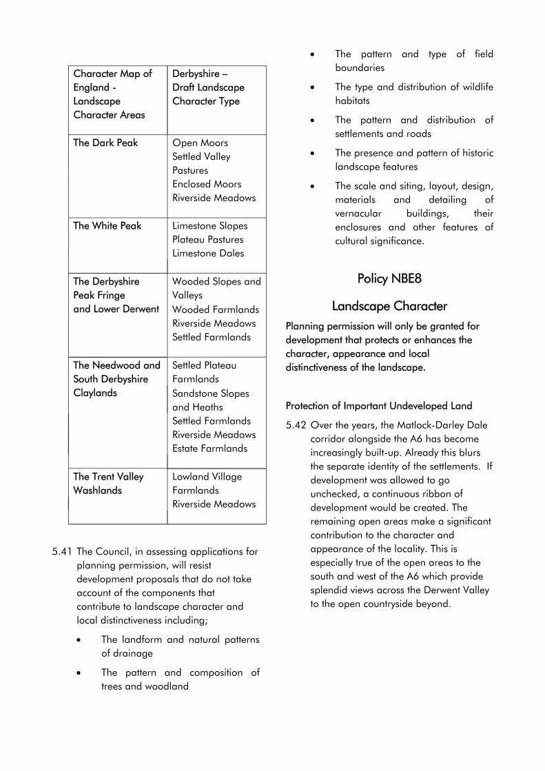
Character Map of England - Landscape Character Areas
Derbyshire – Draft Landscape Character Type
The Dark Peak Open Moors Settled Valley
Pastures Enclosed Moors Riverside Meadows The White Peak Limestone Slopes Plateau Pastures Limestone Dales
Wooded Slopes and Valleys
The Derbyshire Peak Fringe and Lower Derwent Wooded Farmlands Riverside Meadows Settled Farmlands
Settled Plateau Farmlands
The Needwood and South Derbyshire Claylands Sandstone Slopes
and Heaths Settled Farmlands Riverside Meadows Estate Farmlands The Trent Valley Washlands
Lowland Village Farmlands
Riverside Meadows
5.41 The Council, in assessing applications for planning permission, will resist development proposals that do not take account of the components that contribute to landscape character and local distinctiveness including;
• The landform and natural patterns of drainage
• The pattern and composition of trees and woodland
• The pattern and type of field boundaries
• The type and distribution of wildlife habitats
• The pattern and distribution of settlements and roads
• The presence and pattern of historic landscape features
• The scale and siting, layout, design, materials and detailing of vernacular buildings, their enclosures and other features of cultural significance.
Policy NBE8
Landscape Character
Planning permission will only be granted for development that protects or enhances the character, appearance and local distinctiveness of the landscape.
Protection of Important Undeveloped Land
5.42 Over the years, the Matlock-Darley Dale corridor alongside the A6 has become increasingly built-up. Already this blurs the separate identity of the settlements. If development was allowed to go unchecked, a continuous ribbon of development would be created. The remaining open areas make a significant contribution to the character and appearance of the locality. This is especially true of the open areas to the south and west of the A6 which provide splendid views across the Derwent Valley to the open countryside beyond.
59
Policy NBE9
Protecting The Important Open Spaces Alongside The A6 Through Darley
Dale
Planning permission for development will only be granted for development on open spaces alongside the A6 through Darley Dale, as defined on the Proposals Map if;
(a) it consists of an extension of an existing building or;
(b) it is required for the purposes of agriculture, forestry or outdoor recreation or;
(c) it is required for the purpose of regenerating, improving and/or extending the facilities at the Sir Joseph Whitworth Centre
and;
(d) it does not have an adverse impact upon the open character of the area.
The Water Environment
5.43 Climate change and the incidence and severity of flooding events over the past few years has led to the Government giving flood risk issues a higher profile. PPG25 sets out that Government policy is to reduce the risks to people and the developed and natural environment from flooding. It advises that local planning authorities show areas of flood risk on the Proposals Map. As these are subject to continuous review, the Council is concerned that identifying them on the Proposals Map may cause unnecessary concern for land and property owners. These areas are therefore not shown on the Proposals Map. However there are Indicative Flood Plain Maps produced by the Environment Agency that can be viewed at the Council Offices, in Matlock. PPG25 also explains how flood risk
should be considered at all stages of the planning and development process in order to reduce future damage to property and loss of life. It sets out the importance the Government attaches to the management and reduction of flood risk in the land use planning process. It indicates that:
• Development plan policies need to indicate how flood issues are to be considered in the development process.
• The precautionary principle should be applied to flood risk, avoiding risk where possible and managing it elsewhere.
• Developers should contribute towards the cost of flood defences required as a result of development.
• Flood risk management needs to be applied on a whole catchment basis and not restricted to flood plains.
5.44 RSS8 advises that local authorities should ensure that as far as practically possible life and property at risk from flooding or coastal erosion is protected whilst considering alternative approaches to the management of these processes. Although the larger towns of the District lie behind maintained defences where the risk of flooding is reduced, a breach or overtopping of a defence cannot be discounted. The Council will follow the sequential approach set out in PPG25 in assessing applications.
5.45 The Council will consult as appropriate the Environment Agency in respect of development proposals on sites at flood risk identified on their Indicative Flood Plain Maps or on other known areas of flood risk or where development could increase the risk of flooding as a result an
60
increase in the rate of surface water run-off. Where considered necessary to do so the Council will require a developer to submit a flood risk assessment. In some instances the inclusion of appropriate flood mitigation and/or compensation measures may make a proposed development acceptable. In order to determine whether this is the case developers should engage in prior discussions with the local planning authority.
5.46 Where necessary the Council will seek to negotiate the provision of developer contributions towards the provision of works to manage flood risk. All built development tends to extend the area of impermeable ground from which water runs off rather than percolating through the ground. Allowing water to run off sites to enter watercourses quicker, can increase the risk of flooding. PPG25 advocates the use of sustainable drainage systems. The advantage of this type of drainage facility is that it regulates surface water run off from a site so as not to increase the risk of flooding elsewhere and can also serve to contain and reduce pollution. In some cases these types of drainage systems act as havens for wildlife. In appropriate circumstances the Council will seek to integrate the provision of sustainable drainage systems into development proposals.
Policy NBE10
Flood Risk And Surface Water Discharge
Planning permission will be granted provided development would not increase the risk of flooding, or itself be at risk of flooding, and includes the safeguarding of flood defences
and satisfactory access to them and any watercourses for the purposes of maintenance.
In some instances it may be possible to negate or satisfactorily minimise the risk of flooding by the incorporation of flood mitigation and/or compensation measures. In those cases such measures will be required by a condition of the planning permission.
In appropriate circumstances the Council will require the provision of sustainable drainage systems and will impose conditions accordingly.
5.47 Water is a precious natural resource and the protection of water resources from potentially harmful effects of new development is a key part of ensuring a sustainable environment. Watercourses and wetlands can easily be damaged by development that can, for example alter drainage patterns, lower the water table or cause pollution.
5.48 Groundwater resources are a vital component of drinking water supplies providing approximately 35% of all public water supplies. It is also an important source for industry and agriculture as well as sustaining the base flows of rivers. The protection of groundwater is therefore of critical importance because if it becomes polluted, it is almost impossible to rehabilitate. It is therefore necessary to prevent or reduce the risk of groundwater contamination rather than to deal with its consequences.
5.49 The District contains a number of major aquifers that provide high quality water that requires little treatment prior to use. In accordance with the Environment Agency’s Policy and Practice for the Protection of Groundwater, the Council will seek to protect groundwater resources most at risk from pollution. The Council will assess the level of risk in
61
relation to the impact that development has on identified Groundwater Source Protection Zones and by reference to the Environment Agencies Groundwater Vulnerability Maps.
Policy NBE11
Water Quality Protection
Planning permission will only be granted for development if it does not have an adverse impact upon the quality and quantity of groundwater resources or the quality of watercourses.
Where appropriate the Council will impose conditions or seek to negotiate a Section 106 Obligation to secure the provision of mitigation measures prior to the commencement of development to provide protection to water resources.
5.50 In considering applications for planning permission the Council will seek to ensure that there is adequate means of disposing of foul water sewage, without causing contamination of the water environment.
Policy NBE12
Foul Sewage
Planning Permission for Development will only be granted where;
(a) adequate sewage treatment capacity is available or is capable of being made available to accommodate the development or;
(b) it can be demonstrated that where a discharge to a public foul sewer is not feasible that an appropriate non-mains sewerage system can be provided without having an adverse impact upon
the water environment.
In appropriate circumstances the Council will impose conditions or seek to negotiate a Section 106 Obligation to secure the provision of increased sewage treatment capacity or to ensure the continued maintenance of a non-mains sewage system.
Development on Contaminated & Unstable Land
5.51 The priorities set out in the Council’s Corporate Plan for 2003 to 2007 include protecting and improving the safety and health of residents and visitors.
5.52 The development of derelict and contaminated land, if undertaken in an appropriate location can reduce the pressure for development on greenfield sites. This is at the heart of the principles of sustainable development. The Derbyshire Dales Local Plan has therefore an important role to play in facilitating the development of these sites, and ensuring that if development is brought forward on such sites that it is undertaken safely and without detriment to the wider environment.
5.53 Legislation has placed a duty on the Council to prepare a Contaminated Land Strategy. The main vehicle in terms of achieving these aims and objectives is the Contaminated Land Strategy. The Council adopted this in June 2001. The Strategy recognises the importance of the role of planning, in the contribution to the above aims and objectives.
5.54 PPS23 sets out that works, undertaken on any contaminated site should deal with any unacceptable risks to health or the environment, taking into account its actual or intended use. This ‘suitable for use’ principle places an emphasis on dealing with the actual or perceived threats to health, safety or the
62
environment, keeping or bringing back contaminated land into beneficial use and the need to minimise pressures on the development of greenfield sites.
5.55 PPS23 advises that it is necessary to identify at the earliest possible opportunity in the planning process, whether or not a site is contaminated. It goes on that the developer should be responsible for providing this information. Where it is suspected that significant problems of contamination exist, developers should be required to carry out detailed site investigations, prior to planning permission being granted for development.
5.56 In certain parts of the plan area the land is liable to slippage or is otherwise unstable. Generally, this is a result of the underlying geological strata. Such land is either unsuitable for development or would require specialised, expensive foundations. The effects of ground instability vary in their nature, scale and extent and may arise through a series of operations, e.g. the existence of underground mining or engineering works, quarry operations, etc. Land may become unstable as a result of ground compression, either through natural origin or due to human activities such as landfill. Sloping land may also be unstable.
5.57 Whilst, in all cases, instability may arise whether or not there is any development on the surface, it is important to recognise that development itself or the intensification of development may be the triggering factor that initiates instability problems. Potential hazards include subsidence, flood risk and drainage problems. The problems can result in damage to buildings and structures, disruption of communications and services and, in some instances, can
represent a serious risk to public health and safety.
5.58 PPG14 advises that development proposals within such areas must include provision for minimising the risk and effects of land instability on property, infrastructure and the public. This includes the carrying out of appropriate precautionary measures at the planning application stage to evaluate ground conditions and take any appropriate remedial action. In some cases, however, the problems may be so severe that development cannot take place.
5.59 In considering applications for development where it is suspected that a site is either contaminated or unstable, the Council will require applicants to submit as part of their planning application a detailed and independent assessment of the nature and extent of the contamination and/or instability, and identify what remedial or mitigation measures need to be put in place to ensure the development can take place.
5.60 Where remedial works are necessary, the Council require that these are undertaken prior to development commencing.
Policy NBE13
Development On Or Adjacent To Contaminated And Unstable Land
Planning permission will only be granted for development on or adjacent to land that is, or suspected of being, either contaminated or unstable where it can be demonstrated that the development can take place without having an adverse impact upon public health, safety or the local environment.
The Council will impose conditions or seek to negotiate a Section 106 Obligation to ensure that any remedial or mitigation measures to
63
stabilise or decontaminate the site are an integral element of the development process.
Light & Noise Pollution
5.61 Light pollution is caused by excessive or intrusive artificial light arising from poor or insensitive design. Light pollution can have a detrimental effect on the character and amenity of an area after dark.
5.62 PPS23 reminds local planning authorities to take account of the possible polluting impact of lighting in preparing local plan policies. It indicates that local planning authorities should take into account in preparing local plans “the possible impact of potentially polluting development resulting from releases of light”.
5.63 Whilst the intentions of the current policy remain valid, it is only part of a policy that considers issues in relation to pollution prevention in general. In order to increase the importance of this issue it is considered that a criteria based policy be included in the Local Plan that sets out the factors that will be taken into account to ensure that development does not result in light pollution.
5.64 PPG24 highlights the need for policies to ensure, as far as is practicable, that noise sensitive developments are located away from existing sources of significant noise and that potentially noisy developments are located in areas where noise will not be such an important consideration or where its impact can be minimised. PPG24 also states that it may also be appropriate for Local Planning Authorities to adopt policies to avoid potentially noisy developments in areas that have remained relatively undisturbed by noise nuisance.
Policy NBE14
Light And Noise Pollution
Planning permission will only be granted for development if;
(a) it does not have an adverse impact upon the amenity, character and appearance of its immediate or wider surroundings by virtue of light or noise pollution or;
(b) it would not be adversely affected by existing sources of noise or light pollution.
Where appropriate the Council will seek to impose conditions or enter into a Section 106 Obligation to secure the provision of measures that minimise the impact of any noise or light pollution.
Air Quality
5.65 Air quality is important in terms of health, biodiversity and overall quality of life. Improving air quality is one of the Governments Quality of Life objectives. Improving the quality of life, protecting and enhancing the environment, along with protecting and enhancing the safety and health of residents and visitors are key themes in the Council’s Corporate Plan for 2003 to 2007.
5.66 The planning process can have a significant impact both short and long term on air quality. For example, policies that seek to locate development in order to reduce reliance on private transport can help reduce emissions of air pollutants.
5.67 Whilst the planning system complements the pollution control system, not all activities are regulated. In some instances it is necessary for the planning system to impose conditions on development, to minimise the potential risk of pollution.
64
The Council will seek to ensure that decisions made in respect of development proposals take account of the need to safeguard air quality.
5.68 Although the Derbyshire Dales area has no significant air quality problems, policies are still required which seek to continue improving air quality.
Policy NBE15
Air Quality
Planning permission will only be granted for development if;
(a) it does not have an adverse impact upon air quality of its immediate or wider surroundings or;
(b) it would not be adversely affected by existing sources of poor air quality.
Introduction - Historic Built Environment
5.69 The quality of the historic fabric of the District is one of the reasons that the District is an attractive place, where people want to live, work and visit. The historic fabric can be divided into a number of elements; Listed Buildings, Conservation Areas, Historic parks and Gardens, Archaeological features, and World Heritage Sites.
5.70 Both PPG15 and PPG16 make it clear that the historic fabric represents a finite resource and is an irreplaceable asset. Both advise that care must be taken to ensure that it is not destroyed.
5.71 Advice in PPG15 is that local planning authorities should set out clearly their policies for the protection, preservation and enhancement of the historic environment and the factors that will be taken into account in assessing different types of planning application.
5.72 PPG15 advocates a general presumption in favour of the preservation of listed buildings except where a convincing case can be made for the alteration or demolition. It advises that local planning authorities should “have special regard to the desirability of preserving the building or its setting or any features of special architectural or historic interest which it possesses.”
5.73 PPG15 advises that local planning authorities have a duty to formulate and publish proposals for the preservation and enhancement of conservation areas. It also advises that they have a duty to review their area from time to time to consider whether further designation of conservation area is required. Designation of a Conservation Area introduces a general control over the demolition of unlisted buildings and provides the basis for policies designed to preserve or enhance all aspects of the character and appearance that define their special interest.
5.74 PPG16 sets out the Government’s policy on archaeological remains on land, and how they should be preserved or recorded both in an urban setting and in the countryside.
5.75 It advises that there should be a presumption in favour of physical preservation of nationally important archaeological remains and their settings, whether scheduled or not. The advice in relation to remains of lesser importance is that local planning authorities will need to carefully balance the importance of the archaeology against the need for the proposed development. Preference is given to the retention of remains in situ, over excavation.
5.76 PPG16 advises that where the destruction of remains is not justified, and that
65
development would result in destruction, it is entirely reasonable for the planning authority to satisfy itself before granting planning permission that provision for the recording and excavating the remains has been made.
5.77 English Heritage is the Government’s advisor on the protection of England’s historic environment. It has published a variety of guidance relating to the historic built environment. These complement the advice in the Government’s Planning Policy Guidance Notes. The most significant document, in terms of its importance to the planning process is ‘Enabling Development and the Conservation of Heritage Assets’. This provides guidance to local planning authorities on how they should assess applications involving ‘enabling development’. It set out that permission for enabling development should only be granted if the historic asset is not materially harmed, and the applicant demonstrates that on balance, the benefits clearly outweigh any disbenefits, not only to the historic asset or its setting, but to any other relevant planning consideration.
5.78 RSS8 recognises the importance to the region of its historic and cultural heritage and indicates Development Plans should contain policies that seek to preserve and enhance the historic environment. It sets out that wider local strategies (of local authorities and other agencies) should preserve or enhance buildings, landscapes, archaeological remains and settings and should include: identification, assessment and recording where necessary of important cultural assets. It advises that appropriate resources and guidance for their protection, conservation and management, enhancement or regeneration within established
frameworks of policy and initiatives for action should be put in place.
5.79 The policies in the Derby and Derbyshire Joint Structure Plan aim to balance the need to protect the historic fabric with the need for new development. The policies are seen as extending and improving the means of protection for Conservation Areas, Listed Buildings, and other features, and to reflect the important role that conservation can play in the economic regeneration of towns and villages.
5.80 Structure Plan policies relating to the preservation and conservation of listed and other historic buildings, recognise the important contribution they make to the character of the areas in which they are situated. It also seeks to resist development that would affect a site or setting of the Derwent Valley Mills World Heritage Site.
Listed Buildings
5.81 Listed Buildings are buildings listed by the Department of Culture, Media and Sport because of their special architectural or historic interest. There are over 1000 listed buildings in the plan area. The Council has extra controls over works that could affect the special architectural qualities or historic character of listed buildings.
66
Policy NBE16
Development Affecting A Listed
Building
Planning permission for development will only be granted where it does not have an adverse impact upon the special character or setting of a listed building.
5.82 Unless carefully controlled alterations and extensions to listed buildings can have a detrimental impact upon the special features that have resulted in the building being listed. In order to assess the impact that a proposal has on a listed building the Council will require the submission of a full justification statement for the proposed works, and impact of the proposals on the special character of the building.
Policy NBE17
Alterations And Extensions To A Listed Building
Planning permission for development involving alterations or extensions to listed buildings will only be granted where;
(a) the historic form of the building is retained and;
(b) any architectural or historically important elements of the building, are retained in largely unaltered form; and
(c) the proposed design, materials, scale and detailing does not have an adverse impact upon the character and appearance of the listed building.
5.83 It is important that listed buildings have a viable use that enables their upkeep to be maintained. Where a listed building has ceased to be of practical use for its original or existing purpose, a change of
use may be the only way to secure its long-term preservation. Nevertheless, planning permission will normally only be granted for such changes of use where the proposed use would not be detrimental to the building or its setting. In order to assess the impact that a proposal has on a listed building the Council will require the submission of full details of all works.
Policy NBE18
Conversion And Changes Of Use Of A Listed Building
Planning permission for the conversion and/or change of use of a listed building will be granted provide that: (a) the original use is no longer appropriate
or viable, and (b) if the proposed use is not the original
use, it is appropriate to the status of the listed building, and
(c) the proposal will protect the listed building and its setting.
5.84 PPG15 and Circulars 14/97 and 01/2001 define the demolition of a listed building as total or substantial destruction of the building. Consequently, work involving only partial demolition of a listed building is now classed as ‘alteration’ rather than ‘demolition’. All proposals involving the demolition of a listed building will be required to be supported by a full justification statement. The Council, will as a general rule seek to resist the demolition of listed buildings. If the demolition of a listed building is considered necessary, the Council will seek to ensure that an acceptable form of development takes place on the site as soon as possible after demolition has occurred. If permission is granted it will normally be conditional upon English
67
Heritage Architectural Investigation Section being given the opportunity to record the building before demolition takes place.
Policy NBE19
Demolition Of Listed Buildings
Planning permission for development involving the demolition of a listed building will only be granted where;
(a) the building is wholly beyond economic repair and;
(b) it can be demonstrated that every possible effort has been made to continue its current use or find a compatible alternative use that would allow for the retention of the listed building and;
(c) the application is accompanied by a redevelopment scheme for the site, the merits of which would outweigh the loss of the listed building.
The Council will impose conditions or seek to enter into a Section 106 Obligation to ensure the implementation of the redevelopment scheme at the earliest possible opportunity following demolition of the listed building.
Enabling Development
5.85 Development proposals, often adjacent to or within the curtilage of an historic asset, and used to fund remediation or improvement works to an historic asset considered ‘at risk’ of physical deterioration or in a poor or vacant condition is often referred to as enabling development.
5.86 English Heritage published a policy statement on this topic June 1999 - ‘Enabling Development and the Conservation of Heritage Assets’ and
complemented this in June 2001 by ‘A Practical Guide to Assessment’. Both seek to protect and avoid inappropriate development affecting the historic assets and their settings. English Heritage’s guidance indicates that there should be a general presumption against enabling development.
5.87 Proposals for additional development adjacent to or within the curtilage of any historic asset to enable restoration of that asset, need to be carefully considered in the light of the effect of such development on both the existing historic building and its setting. In addition to the following policy the Council, will use as a material planning consideration the detailed advice in English Heritage’s Policy Statement in assessing proposals for enabling development.
Policy NBE20
Enabling Development
Planning permission for development adjacent to or within the curtilage of an Heritage Asset* and used to fund the repair, restoration or improvement of a Heritage Asset will not be granted unless;
(a) it can be demonstrated that it is the only viable means of repairing, restoring or improving the Heritage Asset and;
(b) it would not have an adverse impact on the archaeological, architectural, historic, or landscape interest of the heritage asset or its setting and;
(c) it can be demonstrated that the development is the minimum necessary to secure the long-term future of the heritage asset and;
(d) the benefits that accrue from the development outweigh any long-term disbenefits
68
*Heritage Asset is defined as any scheduled monument and other archaeological remains, listed buildings, other historic buildings of more local significance, conservation areas or registered park and gardens.
Conservation Areas
5.88 The high quality of much of the built environment is reflected in the fact that thirty two conservation areas have been designated within the plan area in the locations shown in the following table:
Table 8 :- Conservation Areas Ashbourne Kirk Ireton Old
Matlock Bolehill Kniveton Osmaston Bonsall Lea/High
Peak Junction
Riber
Brailsford Lumsdale Rocester Brassington Mapleton Shirley Callow Hall,
Matlock Bank
Snelston,
Carsington and Hopton
Matlock Bath
Somersal Herbert
Cromford Matlock Bridge
Sudbury
Gorsey Bank
Matlock Dale
Wirksworth
Hognaston Middleton Stanton Lees
Hulland Norbury
5.89 The precise boundaries of these conservation areas are shown on the Proposals Map.
5.90 During the course of the plan period, the Council will keep under review the extent of all existing conservation areas, and monitor whether it is appropriate to designate any new conservation areas. The Council will use conservation area appraisals to review the need for both new and the extent of existing conservation areas.
5.91 The Council has a duty Under Section 69 of the Planning (Listed Buildings and Conservation Areas) Act 1990 to preserve or enhance the special character of conservation areas. Consequently in considering proposals for development within a conservation area, the Council will require it to preserve or enhance its special character.
5.92 In addition to ensuring that development within a conservation area preserves or enhances the special character of the conservation area, the Council will, where possible, and in partnership with Derbyshire County Council and English Heritage provide grant assistance for environmental improvement works.
5.93 Where it appears to the Council that there is a particular threat to the character or appearance of a conservation area from inappropriate alterations to residential properties that would not normally require planning permission, consideration will be given to the making of an Article 4 Direction The effect of which is to bring these works under planning control. Once in force, planning permission will only be given to works that would not have a detrimental impact on the character or appearance of the conservation area. Article 4 Directions are already in place in the Osmaston, Wirksworth and Matlock Bath conservation areas.
5.94 The Council will require all planning applications in a conservation area to be supported by detailed drawings sufficient to make clear the impact of the proposal upon the character or appearance of the conservation area. Planning permission will normally be refused where the information supplied is not adequate to enable the Council to assess the impact of the proposed development.
69
Policy NBE21
Development Affecting A Conservation Area
Planning permission for development proposals within or adjacent to a Conservation Area will be granted provided that they preserve or enhance the character or appearance of the area.
Shopfronts in Conservation Areas
5.95 PPG 15 indicates that wherever shop fronts of merit survive they should be retained. The removal of traditional shop fronts within conservation areas will therefore be resisted if they are of architectural and/or historic value and contribute to the special character of the area. The Council will seek the restoration and repair of such features in preference to replacement. Where proposals for new shop fronts within conservation areas are considered acceptable they should respect the architectural elements of the building within which they are sited.
5.96 Planning permission for development affecting the external appearance of commercial premises, including replacement shop fronts, will only be granted where the design and materials reflect the character of the building itself and, where appropriate, are also well related to adjacent properties.
Policy NBE22
Shopfronts In Conservation Areas
Planning permission for the replacement of a shopfront within a Conservation Area will only be granted where;
(a) the existing shopfront has little or no
architectural and/or historic value or does not make a contribution to the character of the Conservation Area
Or;
(b) it can be demonstrated that a shopfront of architectural and/or historic value or that makes a contribution to the character of the Conservation Area is wholly beyond repair and restoration
And;
(c) the design and appearance of the new shopfront preserves or enhances the character or appearance of the Conservation Area.
Historic Parks and Gardens
5.97 There are a number of parks and gardens that are included on The Register of Parks and Gardens of Special Historic Interest. Currently these are; Ednaston Manor, Sudbury Hall, the Heights of Abraham, Lovers Walks, High Tor, Derwent Gardens, Sydnope Hall, the Whitworth Institute, and Willersley Castle.
5.98 PPG15 advises that local planning authorities should protect registered parks and gardens in development plans and in determining planning applications. It advises that the effect of development on a registered park or garden or its setting is a material consideration in the determination of a planning application. To ensure that their special character is given adequate protection, as part of its programme of Conservation Area Appraisals the Council will, as appropriate, seek to define the setting of registered parks or gardens.
5.99 The Council will therefore seek to protect these sites from development that would harm their character or setting. However where there is an overriding case to
70
allow development that would result in some loss or disturbance to a registered park or garden, the Council will through the use of conditions or Section 106 Obligation seek to minimise the impact of the development. Where appropriate, the Council will require the investigation and recording of the features of interest prior to the development commencing.
5.100 Proposals likely to have an effect upon the character or setting of a historic park or garden will be assessed against their impact on the features that make it worthy of protection.
5.101 Where a proposal would affect a historic park or garden, applicants may be requested to submit a justification statement prepared by a suitably qualified person or a relevant recognised authority, describing the likely impact of the proposed development upon the park or garden. The statement should set out what mitigating and/or compensatory measures are necessary to protect and enhance the features of interest within the garden.
Policy NBE23
Conservation Of Historic Parks And Gardens
Planning permission will only be granted for development within a Registered Park or Garden, as identified on the Proposals Map, where it does not have an adverse impact upon its character and appearance.
Planning permission will only be granted for development where it does not have an adverse impact upon the setting of a Registered Park or Garden.
Where appropriate the Council will impose conditions or seek to negotiate a Section 106 Obligation to secure appropriate mitigation
and/or compensatory measures to protect the important features of the historic park or garden.
Archaeological Sites and Features
5.102 The plan area has a rich heritage of important archaeological sites with features of national and local importance.
5.103 Appropriate management is, essential to ensure that they survive in good condition. In particular, care must be taken to ensure that archaeological remains are not needlessly or thoughtlessly destroyed.
5.104 In Derbyshire, a Sites and Monuments Record has been drawn up by Derbyshire County Council. It identifies archaeological and heritage features of County importance, including nationally important archaeological sites and Scheduled Ancient Monuments, and is continually being updated.
5.105 The County Council also maintains a list of County Treasures. This is a list of heritage features of public importance by reason of their archaeological, architectural, historic, scenic or scientific interest. The Council considers that the deterioration or destruction of these features would represent a serious loss to our heritage and, should be protected from any adverse impact of development.
5.106 Prior to the determination of any application for planning permission for a proposal that affects or is likely to affect an important archaeological site, and/or its setting, the Council will require the developer to submit an archaeological assessment. This will assess and identify the effect of development on the site’s archaeological importance. It should also demonstrate that all options to
71
minimise or avoid damage to the features of interest have been explored. Where nationally important archaeological remains (whether scheduled or not) are affected by development, preference will be for the preservation of the remains in-situ. Preservation by record should be regarded as a second best option.
Policy NBE24
Archaeological Sites And Heritage Features
Planning permission will not be granted for development likely to disturb or have an adverse impact upon Scheduled Monuments or other nationally important archaeological remains or their setting.
Planning permission for development likely to disturb or have an adverse impact upon other important archaeological or heritage features, or their setting will only be granted where it can be demonstrated that;
(a) the feature can be preserved in-situ, or;
(b) where in-situ preservation is not feasible mitigation measures can be put in place that minimises any adverse impact upon the feature and its setting.
Where appropriate the Council will impose conditions or seek to negotiate a Section 106 Obligation to ensure appropriate investigation and recording, before and during development.
Derwent Valley Mills World Heritage Site
5.107 The Derwent Valley Mills were inscripted as a UNESCO World Heritage Site in December 2001, as recognition of the unique role that the area played in the Industrial Revolution.
5.108 PPG15 sets out that although World Heritage status does not bring any additional statutory controls, it highlights
the international importance of the site as a key material consideration to be taken into account by local planning authorities in determining planning and listed building applications. It advises that local planning authorities should formulate specific planning policies for protecting such sites in Development Plans.
5.109 The Derby and Derbyshire Joint Structure Plan requires careful scrutiny of proposals within the World Heritage Site to ensure that it does not adversely affect the site or its setting, and that where appropriate development should enhance the site or its setting.
5.110The World Heritage Site Management Plan defines the extent of the area and a ‘buffer zone’ within which the Council will seek to ensure that development does not detract from its character, appearance or setting.
Policy NBE25
Derwent Valley Mills World Heritage
Site
Planning permission for development within the Derwent Valley Mills World Heritage Site, as defined on the Proposals Map, will only be granted where it does not have an adverse impact upon its character and appearance.
Planning permission for development within the Derwent Valley Mills World Heritage Site buffer zone, as defined on the Proposals Map, will only be granted where it does not have an adverse impact upon the setting of the World Heritage Site.
Introduction – New Built Development
5.111 New buildings and the areas surrounding them can have a significant effect upon the character and appearance of an area. Their
72
relationship to existing features can be beneficial to an area, but at the same time they can also be detrimental. In the interests of continuing to provide a high quality built environment, in considering proposals for development, the Council has a duty to ensure that the appearance and relationship of new built development to its surroundings maintains, and wherever possible, enhances the quality of the local environment.
5.112 The quality of the local environment within the District is dependent upon ensuring that the standard of new built development is of the highest standard. Good design can promote sustainable development by continuing to make it an attractive place to live, work and visit.
5.113 PPS1 advises that good design should be the aim of all those involved in the development process and should be encouraged everywhere. It goes on to advise that local planning authorities should reject poor design, particularly where their decisions are supported by clear plan policies or supplementary design guidance. Poor design includes development that is clearly out of scale or incompatible with their surroundings. Local planning authorities are encouraged to promote or reinforce local distinctiveness, and give weight to the impact of development on existing buildings, and designated areas such as National Parks, AONB’s and Conservation Areas. Development Plans are encouraged to set out design policies against which development proposals are to be considered.
5.114 Advice in PPG3, PPS6, and PPS7 emphasises the contribution that a high quality environment can have on the quality of life.
5.115 RSS8 sets out that in relation to built development the overall aim is to ensure that employment and housing needs of the region are met, with a view to creating well designed, sustainable places that are safe and feel secure, where people will choose to live, work or take leisure.
5.116 It indicates that housing should be designed to maintain and improve the quality of both urban and rural areas. Good quality housing in urban areas maintains their attractiveness to existing and potential residents.
5.117 It encourages local authorities, developers and other agencies to be innovative in the design of housing and housing layouts, and in order to achieve a high quality living environment seeks provision for more sustainable modes of transport, more efficient use of land, energy and materials, reduced parking provision and flexible highway standards.
5.118 The policies in the Derby and Derbyshire Joint Structure Plan set out that new development should conserve or enhance the quality and local distinctiveness of the natural and built environment, and be well related to its surroundings.
5.119The Council will therefore seek to ensure that it resists development that does not protect and enhance the quality of the built environment throughout the plan area.
Landscape Design in Association With New Development
5.120 Landscape design is an integral part of the planning and design process. Its early consideration is essential to ensure that development both integrates and enhances its surroundings.
73
5.121 The character of both the natural and cultural landscapes in the plan area is diverse. The Council will seek to ensure that all development maintains or enhances the quality of the landscape within which it is located.
5.122 The adoption of clearly defined landscape design principles lays the foundation for a successful scheme. The Council will require all proposals to demonstrate:
• an appreciation of the local environment and the impact of the development on it.
• how valuable existing site features might be incorporated.
• how the impact of the development is minimised.
• proper planning and arrangement of built form, external space, access and circulation
• how appropriate landscape elements and features are to be incorporated throughout the scheme.
• how site security has been considered
5.123The Council will require the submission of a landscape scheme as part of the planning application where proposals are for major developments or where development is proposed in sensitive locations. Development proposals that do not include a landscape scheme where it is considered necessary for one to be submitted as part of the planning application process will be resisted.
Policy NBE26
Landscape Design In Association With New Development
In determining applications for planning permission the Council will consider whether there is a need for the submission, implementation and maintenance of a scheme of landscaping to ensure that the proposed development would integrate with or enhance its surroundings.
Where this is considered to be necessary appropriate conditions will be imposed on any planning permission.
Crime Prevention
5.124 The Council has a duty under Section 17 of the Crime and Disorder Act 1998 that in exercising its functions it shall do all that it reasonably can to prevent crime and disorder in its area. This is an acknowledgement that the decisions made by the Council can have a direct impact on crime and disorder. To make progress on this issue the Council is a lead member of the Safer Derbyshire Dales Community Safety Partnership. This has overseen the preparation of the Derbyshire Dales Crime Reduction and Disorder Strategy. This seeks to increase the number of developments achieving ‘Secured by Design’ accreditation (Strategic Aim1).
5.125 Circular 5/94 “Planning Out Crime” recognises that the planning system is an important factor in a successful crime prevention strategy. It sets out that there should be a balanced approach to design that attempts to reconcile the visual quality of a development with the need for crime prevention. Crime prevention is a material consideration to be taken into account in the determination of a planning application.
74
In relevant circumstances failure to take account of the principles of crime prevention could result in an application for planning permission being refused.
5.126 An environment where the fear of, and opportunity for crime has been reduced improves the quality of life for those living in that area.
5.127Improving the quality of life, protecting and enhancing the environment, along with protecting and enhancing the safety and health of residents and visitors are key themes in the Council’s Corporate Plan for 2003 and 2007. The Council will seek to encourage developers, to bring forward proposals that meet the ‘Secured by Design’ standard, and resist development where the principles of crime prevention are not taken into account.
Policy NBE27
Crime Prevention
Planning permission will only be granted for new build development if it can be demonstrated that the design and layout minimises the opportunities for crime.
Percent for Art
5.128 Public art can significantly improve the general environment of an area and contribute greatly towards the quality of life. It can be a means to promote the image and attributes of the District and reinforce a sense of local identity. In this respect public art can take many different forms including major pieces of sculpture, brass plaques inlaid in paving to mark various footpaths, tiling on floors or walls, door handle designs, shapes of swimming pools or reception desks.
5.129 The Arts Council has promoted the Percent for Art scheme since 1988. This scheme seeks to encourage developers of major projects to set aside a proportion of their capital budget to commission new works of art and craft.
5.130 The Councils Arts Strategy recognises the benefits of public art, and sets out that the Percent for Art Scheme would assist in levering in substantial money which would otherwise not be available for public art development. It encourages the inclusion of a policy in relation to the Percent for Art Scheme in the Derbyshire Dales Local Plan.
5.131 It is also recognised by the Council’s Arts Strategy and the Council’s Economic Development Strategy that works of art can be used to promote and market the district, as a visitor attraction, and as a high quality location for inward investment.
5.132 Major developments have a more significant impact upon the environment and in most cases should be able to contribute some of the profit from the development towards the cost of artwork. The levels of profit associated with smaller developments would make it unreasonable to require them to participate in the Percent for Art scheme. The Council will therefore seek to negotiate the provision of public pieces of art as part of major developments proposals.
Policy NBE28
Percent For Art
In considering development proposals, the Council will assess the potential for and encourage the integration of works of public art or environmental art into appropriate new development, refurbishment and landscaping schemes. Such provision will be sought through negotiation in larger development schemes or in sensitive locations.
75

76

CHAPTER 6
Town Centres & Retailing
Objectives
• to protect and enhance the vitality and viability of town centres
• to encourage new retail development that contributes to the achievement of sustainable development
• to protect and enhance the character and appearance of town centres
• to protect important local and village shops and services
Introduction
6.1 A healthy and attractive town centre, readily accessible, with a wide range of uses, including employment, shopping, offices and leisure facilities offers the potential to reduce the need to travel, and reduce reliance upon the private car.
6.2 The Government’s Rural White Paper (November 2000) sets out that market towns play a critical role in helping rural communities to thrive and regenerate. It acknowledges that the shift of services to larger towns has undermined the role of some market towns. It sets out that there is a need to reinforce the role for market towns and their potential to support more sustainable patterns of development by ensuring that they are the focus of a range of private and public services to which people have access.
6.3 PPS6 sets out the Government’s latest policy guidance on town centres, and retail development. The key features of the guidance include;
• an emphasis on a plan-led approach to promoting development in town centres
• an emphasis on a sequential approach to selecting sites for retail, employment, leisure and other key town centre uses
• the promotion of mixed use development in town centres
• the need for a coherent town centre parking strategy
• the promotion of town centre management
• the promotion of good urban design in town centres
• a clarification of the basis for assessing proposals for retail development in relation to town centres and out of centre locations
6.4 PPG13 emphasises the need to focus major generators of travel demand in city, town, and district centres in preference to out of centre locations. It advises that day-to-day facilities such as primary schools, health centres, convenience shops, and branch libraries, should be located near to their clients in local and rural service centres to encourage safe and easy access, particularly by walking and cycling. PPG13 complements PPS6 in that it reinforces the Government sequential approach to development.
6.5 In locations away from large urban areas it advises local authorities to focus most development comprising jobs, shopping, leisure, and services in or near to local service centres to help to ensure that it is served by public transport and provides for some potential access by walking and cycling. It advises that these centres (either market towns or large villages or groups of villages) should be identified in the development plan as the preferred locations for such development.
6.6 RSS8 sets out that it is important to recognise the value of maintaining and enhancing the region’s network of town centres. Where there is a proven need for new retail floorspace (both new and extensions) it requires that it should be located on the basis of the sequential
77
approach advocated in PPS6. It encourages mixed-use developments to stimulate the interaction of shopping and culture, leisure, entertainment, education and residential uses, to keep central areas vibrant, thereby reducing the need to travel. It also stresses the importance of encouraging measures to increase the attractiveness and safety of central area environments, including improvements to the accessibility of centres by public transport, cycling and walking.
6.7 The Derby and Derbyshire Joint Structure Plan sets out a hierarchy of centres across Derbyshire, including the sub-regional centres of Derby and Chesterfield, traditional town centres, district centres in Chesterfield and Derby, and local and village centres. It sets out that the general objectives of the policies are to maintain and enhance the vitality and viability of the existing centres, regardless of size. In terms of this hierarchy it defines Ashbourne, Matlock, Matlock Bath, and Wirksworth as ‘Town Centres’, and allows for ‘Local/Village Centres’ to be defined in Local Plans.
6.8 In accordance with the sequential approach advocated in PPS 6 it gives preference to new shopping and other major travel generating uses within existing centres; subject to it being compatible to the scale and character of the town; does not have an adverse impact on the vitality and viability of other nearby centres; and is accessible by a variety of means of transport.
6.9 The policies in the Derby and Derbyshire Joint Structure Plan set out that development in Edge-of-Centre locations and Out-of-Centre locations will only be permitted if there is a proven need for the development, that it cannot be accommodated within the centre or edge-of-centre location, and will not have an
adverse impact upon the vitality and viability of any existing nearby centre.
6.10 The Derby and Derbyshire Joint Structure Plan also sets out that provision will be made in Local Plans for the identification of local and village centres and for the development of small local shops. It also seeks to resist the loss of existing shopping facilities in village centres, except where there are adequate alternative facilities in the locality or the existing use is no longer viable.
Retail Development in Town Centres
6.11 The definition of town centre in PPS6 is one where a broad range of facilities and services are provided and which fulfil a function as a focus for both community and for public transport. The extent of the Town Centres of Matlock, Ashbourne, Wirksworth and Matlock Bath are defined on the Proposals Map using the following definition;
(i) The predominant uses in any continuous and contiguous frontage consist of shops, financial and professional services (including banks, and building societies) and food and drink establishments.
(ii) The mix of uses adjacent to, or situated within any continuous and contiguous frontage, provide a broad range of facilities and services for the community
6.12 Within the defined Town Centres the Council’s preference is for development to fall within Use Class A1 Shops, Use Class A2 Financial and Professional Services, Use Class A3 Restaurants and Cafes, Use Class A4 Drinking Establishments and Use Class A5 Hot Food Takeaway.
78
Policy S1
Retail Development In The Town Centres
Planning permission for retail development and other uses appropriate within a town centre (as defined on the Proposals Map) will be granted if it;
(a) is in scale and character with the town centre and;
(b) is well related or capable of being well related to the public transport network and;
(c) does not have an adverse impact upon the character and appearance of the town centre
Edge of Centre and Out of Centre Development
6.13 PPS6 defines an edge of centre location as being a site normally within 300 metres easy walking distance of the primary shopping area, where the potential for linked trips to the town centre exists. In this context the areas defined on the Proposals Map in relation to policy S1 represent the primary shopping areas.
6.14 Preference is for new development to locate in Town Centres and only in Edge of Centres locations where it can be demonstrated that there is a need for the development, and it is not capable of being accommodated within the Town Centre.
Policy S2
Retail Development In Edge Of Centre Locations
Planning permission for retail development and other development appropriate within a town centre will be granted on sites on the edge of town centres, providing that;
(a) there is a proven need for the
development and;
(b) it cannot be accommodated within that centre or in any other nearby centre and;
(c) is in scale and character with the town centre and;
(d) does not have an adverse impact upon the vitality and viability of the town centre or any existing nearby centre and;
(e) is well related or capable of being well related to the public transport network and;
(f) is within easy walking distance of the adjacent town centre and;
(g) does not have an adverse impact upon the character and appearance of the surrounding area.
6.15 PPS6 defines Out of Centre locations as being a location that is clearly separated from a town centre, but not necessarily outside the urban area. In accordance with the sequential approach set out in PPS6, development proposals in out of centre locations will only be acceptable, where it can be demonstrated that the proposals cannot be accommodated either within or on the edge of the town centres.
Policy S3
Retail Development In Out Of Centre Locations
Planning permission for retail development and other development appropriate within a town centre will be granted on sites in out of centre locations providing that;
(a) there is a proven need for the development and;
(b) it cannot be accommodated within a town centre or edge of centre location and;
79
(c) is in scale and character with the surrounding area and;
(d) does not have an adverse impact upon the vitality and viability on any town centre or other nearby centre and;
(e) is easily accessible by a choice of means of transport and;
(f) does not have an adverse impact upon the character and appearance of the surrounding area.
Primary Shopping Frontages
6.16 PPS6 advises that local authorities should consider the designation of primary frontages within town centres, where there is a need to distinguish between different parts of the centre to reflect their relative importance. Primary shopping frontages are defined on the Proposals Map for Matlock, Ashbourne, Wirksworth and Matlock Bath. In Matlock, Ashbourne and Wirksworth the Council will seek to ensure that the emphasis is on retaining a high proportion of retail shops, in order to maintain the role of these frontages as the principal location for shopping in each town. Matlock Bath town centre, however, does not perform the same role as Matlock, Ashbourne and Wirksworth as the principal location for shopping for local residents. Its role as a town centre derives from its attraction as a visitor centre. To reflect this role, the Council will seek to maintain and enhance the role of Matlock Bath town centre in providing for the needs of visitors and tourists while retaining provision for the basis retail needs of the resident population.
Policy S4
Non Retail Uses In Primary Shopping Frontages
Within the defined Primary Shopping Frontages, as defined on the Proposals Map, planning permission will only be granted for the change of use from retail to non retail uses if it does not individually or cumulatively have an adverse impact upon the vitality and viability of the town centre.
Amusement Centres
6.17 The presence of large numbers of visitors in one location can lead to pressure for the provision of amusement centres. These tend to be noisy and visually intrusive in the street scene. The over provision of amusement arcades within one location can have a detrimental impact upon the vitality and viability of the town centre.
6.18 PPS6 advises that amusement centres are most appropriately sited in secondary shopping areas, or in areas of mixed commercial development. It also advises that they will normally be out of place in conservation areas or other places of special architectural or historic character.
6.19 In Matlock Bath any further provision will have an adverse impact upon the vitality and viability of the town centre, as well as have a detrimental impact upon its character and appearance. The Council will also seek resist proposals for amusement centres in conservation areas, or where the proposal involves the re-use of a listed building.
80
Policy S5
Amusement Centres
Planning permission for an amusement centre will only be granted if it;
(a) is situated within a defined town centre as defined on the Proposals Map and;
(b) is situated outside the Defined Primary Shopping Frontages, as defined on the Proposals Map and;
(c) does not individually or cumulatively have an adverse impact upon the vitality and viability of the town centre and;
(d) does not have a detrimental impact upon the character and appearance of the town centre and;
(e) does not create unacceptable problems in terms of the relationship between the proposal and the neighbouring uses beyond the development site.
The Appearance of Town Centres
6.20 An attractive town centre helps to maintain its vitality and viability, as well as contribute significantly to the achievement of sustainable development. The Council will seek to ensure that when considering proposals for alterations to shopfronts, or other fixtures that they do not have an adverse impact upon the character and appearance of the surrounding area.
6.21 Where a proposed new shop front is situated within a conservation area or the property is a listed building, the Council will seek the retention and restoration of existing shop fronts in preference to their replacement.
Policy S6
The Design And Appearance Of Shops And Commercial Premises
Planning permission for development affecting the external appearance of retail and commercial premises, will only be granted where the design and appearance does not have an adverse impact upon the character and appearance of the building and the surrounding area.
6.22 In recent years there has been an increase in the number of shops wishing to install permanent security shutters. Unless sensitively designed these can have a detrimental impact upon the appearance of both the individual property and the town centre streetscene.
Policy S7
Shopfront Security
Planning permission for the installation of shopfront security will only be granted if it does not have an adverse impact upon the character and appearance of the building and the surrounding area when the proposed security feature is in situ.
Shopping in Matlock
6.23 Matlock is the main shopping centre in the local plan area. Much of the town centre is a Conservation Area. There is a substantial visitor trade particularly in the summer months.
6.24 The town is fortunate in that the River Derwent flows through the centre. This asset is however, largely ignored. Commercial premises turn their back on the river rather than seeking to integrate its undoubted attraction into what could be a unique shopping experience. The
81
Council will therefore seek to encourage retail development that takes advantage of the pleasant riverside environment.
Policy S8
Development To Realise The Potential Of The River Derwent
Planning permission for developments on the west of Bakewell Road and east of Dale Road, Matlock will be granted if;
(a) if it is part of, or would not prejudice, a comprehensive scheme covering the entire river frontage from the proposed junction of Bakewell Road and the A6 Link Road [Policy TR11] in the north to the railway bridge in the south; and;
(b) it protects and enhances the character and appearance and the surrounding area.
6.25 To meet the quantitative and qualitative retail needs of Matlock, the Council has granted planning permission for a new supermarket at Cawdor Quarry. This development is part of larger redevelopment proposals for Cawdor Quarry. These proposals will bring wider benefits to Matlock. It is therefore necessary to safeguard this site until such times as the development is complete.
Policy S9
Development Of A Supermarket, Matlock
Within the site identified on the Proposals Map for a supermarket, proposals that would prejudice the development of the supermarket will not be permitted.
Local Centres Serving Market Towns and Other Settlements.
6.26 Outside the Defined Town Centres, but still within the Settlement Frameworks of Market Towns and Other Settlements there are a number of small local centres and individual shops serving the day-to-day needs of local communities. These are important to the achievement of sustainable development, as they reduce the need for people to travel by car to town centres.
6.27 Many local centres already contain a number of non-retail uses such as offices, professional services and community facilities. These are generally appropriate in local centres. The Council, will however, seek to ensure that within existing local centres there is a suitable mix of uses, and that the scale of any new development does not undermine the vitality and viability of the local shopping centre, or any nearby town centre.
Policy S10
Development In Local Shopping Centres
Planning permission for new build retail development or the extension of existing retail units within the Defined Local Shopping Centres Shopping Frontages, as defined on the Proposals Map, will be granted if;
(a) the scale of development individually or cumulatively does not have an adverse impact upon the vitality and viability of the local shopping centre or nearby town centre and;
(b) it does not have adverse impact upon the character and appearance of the surrounding area.
Within the shopping frontages of the local shopping centres, as defined on the Proposals
82
Map, planning permission will only be granted for change of use from retail to non retail uses if it would not individually or cumulatively have an adverse impact upon the vitality and viability of the local shopping centre.
Individual Shops and Village Shops
6.28 In more remote residential areas and villages the Council wishes to encourage the provision of additional and the retention of as much local shopping as possible. In many cases there may be only one shop or post office serving the local community. These services and facilities play an important role in terms of sustainable development by the reduction of outward vehicular movements for essential needs.
Policy S11
Individual And Village Shops
In more remote residential areas and villages planning permission for additional retail facilities or the extension of existing retail units will be granted provided that:
(a) the scale of development does not
adversely affect the vitality and viability of the local shopping centre or nearby town centre, and
(b) the development does not adversely affect the character and appearance of the area.
6.29 Proposals that would result in the loss of important local services and facilities including shops, and public houses will not be granted planning permission until all possible options have been explored to maintain the existing use. As part of their submissions for planning permission applicants will be required to demonstrate the extent to which they have marketed the business as a going concern, and the viability of the options that they have
considered. The loss of an important local facility, especially where it is the sole operation, will be the last option.
Policy S12
Important Local Services And Facilities
Planning permission for development which would result in the loss of a local shop or other important local facility or service will not be granted unless there are adequate alternative facilities in the locality, or it can be demonstrated that the existing use is no longer financially or commercially viable and there are no other viable means of maintaining the existing use.
83

CHAPTER 7
Transportation
Objectives
• To create an environment that ensures new development contributes towards the overall reduction in the reliance of the private car
• To facilitate the integration of new development with the existing public transport, cycling and pedestrian network
• To facilitate the development of extensions to the existing public transport, cycling and pedestrian network
• To ensure that highway safety is not compromised by new development
• To safeguard land necessary for the implementation of transportation projects that contribute to the achievement of sustainable development
Introduction
7.1 Travel is an important part of daily life. No matter how long or short, nearly everybody makes some sort of journey everyday, if only to go to the shops, to school or to visit friends.
7.2 The provision and maintenance of a safe, efficient, and integrated transport system is vital to the quality of life in the District. A growing reliance on the car is however, having serious implications for congestion, the environment and road safety.
7.3 For people without access to a car, getting around is sometimes difficult, unpleasant and intimidating. In rural areas the lack of adequate public transport to gain access to services and facilities can often leave members of the community feeling vulnerable and isolated.
7.4 A good transport network is essential to meeting the Council’s priorities in its Corporate Plan of improving access to services and supporting delivery improvements.
7.5 PPG13 sets out that the Governments aims and objectives are to integrate planning and transport at national, regional, strategic and local level in order to:
• Promote more sustainable transport choices for people and for moving freight;
• Promote accessibility to jobs, shopping, leisure facilities and services by public transport, walking and cycling and;
• Reduce the need to travel, especially by car.
7.6 In order to deliver these objectives PPG13 advises that when preparing development plans and considering planning applications, local planning authorities should;
• Actively manage the pattern of urban growth to make the fullest use of public transport, and focus major generators of travel demand in city, town and district centres and near to major public transport interchanges;
• Locate day-to-day facilities which need to be near their clients in local centres so that they are accessible by walking and cycling;
• Accommodate housing principally within existing urban areas, planning for increased intensity of development for both housing and other uses at locations which are highly accessible by public transport, walking and cycling;
85
• Ensure that development comprising jobs, shopping, leisure and services offers a realistic choice of access by public transport, walking and cycling, recognising that this may be less achievable in some rural areas;
• In rural areas, locate most development for housing, jobs, shopping, leisure and services in local service centres which are designated in the development plan to act as focal points for housing, transport and other services, and encourage better transport provision in the countryside;
• Ensure that strategies in the development and local transport plan complement each other and that consideration of development plan allocations and local transport investment and priorities are closely linked;
• Use parking policies, alongside other planning and transport measures, to promote sustainable transport choices and reduce reliance on the car for work and other journeys;
• Give priority to people over ease of traffic movement and plan to provide more road space to pedestrians, cyclists and public transport in town centres, local neighbourhoods and other areas with a mixture of land uses;
• Ensure that the needs of disabled people - as pedestrians, public transport users and motorists – are taken into account in the implementation of planning policies and traffic management schemes, and in the design of individual developments;
• Consider how best to reduce crime and the fear of crime, and seek by the design and layout of developments and areas, to secure community safety and road safety; and
• Protect sites and routes that could be critical in developing infrastructure to widen transport choices for both passengers and freight movements.
7.7 By shaping patterns of development and influencing the location, scale, density and mix of land uses, the Local Plan can help reduce the need to travel, reduce the length of journeys and make it safer and easier for people to access jobs, shops, leisure facilities and services by means of transport other than by private car.
7.8 The Derby and Derbyshire Joint Structure Plan places an emphasis on providing for accessibility to services and facilities, rather than on providing for increased individual mobility. It sets out that:
• Development should be concentrated within existing urban areas as far as possible;
• Dispersed patterns of development and development in areas that cannot be served by public transport should be avoided;
• Employment and housing development should enable people to live close to their place of work;
7.9 The Derby and Derbyshire Joint Structure Plan requires new development be in locations well served by public transport, and that provision should be made for safe and convenient access, internal circulation and for links with existing developments, and that such provision should be for public transport,
86
pedestrians, cyclists, disabled people and vehicles.
7.10 The Derbyshire Local Transport Plan (LTP) seeks to implement a strategic approach to transport planning. It sets out detailed investment proposals for the period 2001-2006. PPG13 advises that strategies in the development plan and local transport plan should be complementary. The strategy adopted throughout the Local Plan has sought to ensure that the location of new development is in accordance with the advice set out in PPG13 and complements the Derbyshire LTP.
7.11 The Peak Park Transport Forum, of which the Council is a member, has been responsible for the South Pennine Integrated Transport Strategy (SPITS). The strategic aims of SPITS are;
• Improve trans-Pennine rail services
• Restrain traffic on most cross Pennine roads to limit traffic growth
• Create an improved and safer environment for residents and visitors
• Conserve and enhance the National Park
• Help to re-invigorate the economies of urban areas surrounding the National Park
• Improve road corridors in the north and to the south of the National Park
• Re-route cross-park cars and lorries
• Reopening the Matlock-Buxton Rail line
• Faster and more frequent trains on the north and south trans-Pennine rail routes
• Increased use of rail for carrying freight
• Lower traffic speeds
• Traffic Calming on the main routes within the National Park and surrounding urban areas.
Impact of Development
7.12 It is important to ensure that highway problems are not created as a result of allowing new development. The Council will therefore continue to ensure that regard is given to the environmental and road safety implications of traffic generation from proposed developments. In assessing individual proposals the Council will seek advice from the Highway Authority and the Highways Agency as appropriate.
7.13 In circumstances where a safe access can be achieved but the proposed development would create or worsen traffic problems on the highway network, planning permission will be refused unless applicants are willing to incorporate or finance the works necessary to alleviate the problem. This could include developers making contributions to, or the provision of, public transport or road improvements. Larger development proposals and smaller schemes with significant transport implications will be required to submit transport assessments.
87
Policy TR1
Access Requirements And The Impact Of New Development
Planning permission will be granted for development requiring to be served by vehicles provided that:
(a) the development would be served by a safe access with appropriate gradient, width, alignment and visibility and;
(b) the site is accessible to a road network of adequate standard to accommodate the anticipated traffic generated by the development safely and without detriment to the character of the road network and;
(c) where relevant, circulation within the site is available or can be achieved without detriment to the appearance or amenity of the area.
Where a proposed development is likely to generate significant demand for extra journeys the council will require the submission of a transport assessment to identify the potential impact of traffic generated by the proposal and set out measures to offset any adverse impact.
Where appropriate the Council will impose conditions or seek to enter into a Section 106 Obligation to ensure the implementation of measures necessary to offset any adverse impact.
Travel Plans
7.14 Travel Plans can raise the awareness of the impact of travel decisions amongst larger employers, as well as contribute towards the delivery of sustainable transport objectives by reducing the reliance on the private car. PPG13 and the Derby and Derbyshire Joint Structure Plan set out that travel plans should be
an integral part of the planning process for developments likely to have significant transport implications. The Council will therefore require the submission of a Travel Plan for developments likely to have significant transport implications. The Council will require the Travel Plan to include a package of practical measures to encourage staff to choose alternatives to single-occupancy car-use, and to reduce the need to travel both to and from their work. The Council will negotiate with developers to ensure that the package of measures included in the Travel Plan makes a positive impact. This will typically include such measures as setting up a car sharing scheme; providing cycle facilities; negotiating improved bus services; offering attractive flexible-working practices; restricting and/or charging for car parking; and setting up video conferencing facilities to cut business travel.
Policy TR2
Travel Plans
Planning permission will only be granted for employment, retail, leisure, and educational developments likely to generate significant numbers of vehicular movements where proposals are accompanied by a travel plan. The Council will impose conditions or seek to enter into a Section 106 Obligation to ensure that all or part of the travel plan is implemented.
Public Transport
7.15 A network of commercial and contracted bus services serves the plan area. The market towns of Matlock, Wirksworth and Ashbourne are relatively well served, whereas many of the outlying settlements
88
have infrequent services. In addition, there is a limited network of community transport services operated with County Council support specifically for people with disabilities.
7.16 The Derbyshire LTP aims to create a more reliable and integrated public transport network. The Council, in conjunction with the highway authority and the bus operators, will seek to encourage the provision of new, and the extension of existing bus services. Major development proposals will be only be approved if they are well related or capable of being served by public transport.
Policy TR3
Provision For Public Transport
Planning permission will be granted for new residential, employment, educational and recreational developments provided that;
(a) they are well related to, or capable of being well related to the public transport network, and;
(b) where appropriate the design and layout of the development makes provision for buses to circulate freely within the site and be readily accessible to disabled people and those with restricted mobility.
7.17 Matlock, Matlock Bath and Cromford are served by a local train service from Derby. This line allows connections to be made to the national inter-city network. Many people rely on the service for their journeys to and from work and it is a means by which tourists can visit the area without causing road congestion. A short section of the operational Derby to Stoke
railway line also crosses the southern edge of the plan area.
7.18 A feasibility study was undertaken to assess the potential for the reinstatement of the Derby to Manchester line between Matlock and Buxton. The Study concluded that there were no insurmountable engineering difficulties to re-opening the railway. However, the project was unlikely to be economically viable in the short-term, and that no further work should be undertaken on the project. Peak Rail, continue to have aspirations in respect of the extension of their operation to Rowsley from Darley Dale. The route of this extension will be protected from prejudicial development.
7.19 The Ecclesbourne Valley Railway Association is working in partnership with Wyvern Rail to re-open the Duffield to Wirksworth railway line. This has been subject to a fund raising share issue in Spring 2002, and it is anticipated that the whole route will be reopened by 2007.
7.20 These routes are safeguarded from development that may prejudice their future re-opening.
Policy TR4
Safeguarding The Reinstatement Of Railway Lines
Planning permission will not be granted for any development on land identified on the Proposals Map, which would be prejudicial to the Peak Rail extension to Rowsley and Wirksworth to Duffield lines.
Strategic Rail Freight Site
7.21 The Wirksworth station yard is designated as a strategic freight site by the determining rail authorities for rail freight purposes. While the date of its
89
use for such purposes is not yet known it is important to protect the site from any development that may prejudice such use.
Policy TR5
Strategic Rail Freight Site
Planning permission will not be granted for any development on land identified on the Proposals Map at Wirksworth Station Yard that would prejudice the establishment of a Strategic Rail Freight Facility.
Pedestrians
7.22 The District benefits from an extensive network of public footpaths linking the various settlements and radiating out into the countryside. Within settlements, the public footpath network generally provides good links between areas of housing, employment, shops and community facilities. The Council will seek to ensure that all new development especially new housing is well related to the existing footpath network and that, wherever necessary, new links are provided. Within larger residential developments the Council will seek to ensure that pedestrian links to services and other facilities are provided that encourage their use in preference to the private car.
7.23 The Council will take into account the needs of disabled people, elderly people and people with prams and pushchairs when considering proposals for new pedestrian facilities, or alterations to existing facilities. In accordance with the Council’s Community Safety Strategy the Council will also seek to create safer pedestrian environments by ensuring that the potential for, and fear of crime
is taken into account when considering development proposals.
Policy TR6
Pedestrian Provision
Planning permission for new development will only be granted where pedestrian access and safety is maintained or enhanced.
Planning permission will be granted for new development provided that;
(a) pedestrian routes are provided within the development site to facilitate access to local services and facilities and;
(b) the design and layout of the pedestrian routes provides convenient access to local services and facilities.
Cycling
7.24 The Derbyshire Dales Cycling Strategy encourages and facilitates cycling in the District. It seeks to encourage further use of the bicycle both as a means of recreation and as a viable alternative to the car.
7.25 In the UK most cycle journeys are for utility rather than leisure purposes. Fast, safe and direct routes that are convenient are therefore of great importance to the daily cyclist and potential new cyclists. One of the primary objectives of Derbyshire Dales Cycling Strategy is to encourage the development of infrastructure to assist cyclists reach destinations safely and conveniently on attractive routes. The Council is therefore working in partnership with the highways authority and Sustrans to secure the provision of new routes such as the Pennine Cycleway and the Derwent Valley Cycleway.
90
Policy TR7
Cycling Provision
Planning permission will only be granted for new development provided that;
(a) cycle routes are provided within the development site to facilitate access to local services and facilities and;
(b) the design and layout of the cycle routes are an integral element of the sites transport network and provides convenient access to local services and facilities.
Car, Motorcycle, Moped and Cycle Parking
7.26 PPG13 sets out national maximum parking standards for various forms of land use and development. It advises that in locations either readily accessible to public car parking provision, or which are well served by public transport, car parking provision in conjunction with development should be significantly below the maximum standard.
7.27 The parking standards in the adopted Local Plan are minimum standards and not maximum standards. In 1998 Derbyshire County Council amended their minimum standards to maximum standards. Whilst this was intended as an interim measure it is not proposed to make any changes to these standards.
7.28 RSS8 sets out maximum parking standards for employment uses (Use Classes B1, B2 and B8) and other uses. These standards have been adopted by the Council, and supersede those set by Derbyshire County Council.
7.29 The Council will therefore require developments to provide parking facilities in accordance with the maximum parking set out in Appendix 4. In locations with good access to public transport, or where
town centre car parking is conveniently available, the Council may allow proposals with car parking significantly below the maximum standards set out in Appendix 4. In locations where developments are not able to provide a minimum operational number of car parking spaces, the Council will seek to negotiate a Section 106 Obligation to finance the increased provision of public car parking in nearby locations.
7.30 To encourage cycling and motorcycles/mopeds as a viable alternative means of transport to the car the Council will require, in appropriate circumstances, the provision of cycle and motorcycle/mopeds parking.
Policy TR8
Parking Requirements For New Development
Planning permission will only be granted for development where the provision for car, motorcycles, mopeds and cycle parking is in accordance with the Council’s standards set out in Appendix 4.
Where development is proposed in locations which are either readily accessible to public car parking provision, or are well-served by public transport, the Council will seek to secure car parking provision significantly below the maximum standards.
Where the minimum operational number of car parking spaces cannot be provided on-site, the Council will seek to enter into a Section 106 Obligation to secure contributions from developers for provision of public car parking at an alternative nearby location. Coach Parking
7.31 The Council’s economy is reliant upon tourist visitors, many of whom travel to the
91
District by coach. Lack of suitable coach parking facilities may lead to problems of congestion, loss of on-street parking facilities for essential road users, and environmental nuisance. It is therefore necessary to ensure that there is a network of sites for coach parking in the towns throughout the District.
Policy TR9
Public Coach Park
Planning permission will be granted for coach parking facilities on sites within the settlement frameworks of the Market Towns as defined on the Proposals Map, where;
(a) the site is easily accessible to the town centre on foot and;
(b) the proposed development would not create unacceptable problems in terms of the relationship between the proposal and the neighbouring uses beyond the development site.
Lorry Parking
7.32 The haulage industry is an important part of the District’s economy. However, the indiscriminate parking of lorries and heavy commercial vehicles within residential areas can have an adverse impact upon the amenity of those living there. It is necessary therefore to ensure that so far as possible facilities are available to allow lorry parking to occur in appropriate locations. Planning permission for the development of a haulage depot has been granted at Longcliffe. This site has been safeguarded from development likely to prejudice their development as lorry parking.
Policy TR10
Safeguarding Haulage Depot, Longcliffe
Planning permission will not be granted for any development that would prejudice the development of land at Longcliffe, as identified on the Proposals Map, for use as lorry parking and haulage depot.
New Highway Schemes
7.33 In Matlock the most significant highway problems are the result of traffic converging on Crown Square. The delays from congestion result in increased journey costs, noise and fumes for pedestrians, and the volume of traffic necessitate safety barriers, which are unsightly and inconvenient to shoppers.
7.34 Planning permission has been granted to redevelop Cawdor Quarry for residential, retail and employment use. The development of this site involves the construction of the town centre relief road. The situation in Crown Square will be improved by the construction of this road. However until the road is constructed it is important that the land is safeguarded from development likely to prejudice its implementation.
7.35 The Derby and Derbyshire Joint Structure Plan and the Derbyshire Local Transport Plan (LTP) make reference to a bypass for Ashbourne. Although there is no firm date for this scheme and no route has yet been identified, it is one of the schemes that will be considered for inclusion in the next LTP and possible construction in the period 2006-2011. The Council does however support the implementation of this scheme, and will work with the highways authority to secure its implementation at the earliest opportunity.
92

Policy TR11
Safeguarding The Route Of The A6 Link Road, Matlock
Planning permission will not be granted for development on land at Matlock as identified on the Proposals Map that would prejudice the construction of the A6 Link Road.
93

CHAPTER 8
Infrastructure & Community Facilities
Objectives
• to safeguard sites required for community purposes from prejudicial development
• to ensure that community infrastructure is sufficient to meet the needs of the community
• to support the development of renewable energy sources in appropriate locations
• to balance the needs of the telecommunications industry with their impact on the environmental and public health
• to ensure that all development can be adequately served by utility infrastructure.
Introduction
8.1 A wide range of services and facilities are required to serve and support the population. These include essential services and community facilities to meet the everyday needs of residents.
8.2 The role of the Local Plan in this respect is to:
• ensure that where new and additional community facilities are required that their development is not prejudiced
• ensure that development only takes place where infrastructure is capable of accommodating it.
Community Facilities
8.3 In order to fulfil its function and to provide the necessary services and facilities, the County Council has identified sites that they intend to develop. To ensure these sites remain
available for development as community facilities it is necessary to safeguard them from prejudicial development. In addition to the sites that the County Council intend to develop, there are a number of other sites where plans for the provision of community facilities are well advanced. The Council wish to see these sites also protected from any prejudicial development.
Policy CS1
Sites Required For Community Facilities
Planning permission will not be granted for any development that would prejudice the development of the following sites as identified on the Proposals Map;
(a) Replacement primary school, land off Luke Lane, Brailsford
(b) Replacement primary school, land off North Street, Cromford
(c) Replacement primary school and playing fields, land off Church Road, Darley Dale
(d) Replacement primary school, land to north of Main Street, Kirk Ireton
(e) Replacement primary school, land off Main Street, Middleton-By-Wirksworth
(f) School playing fields, land to rear of Parochial CE Primary School, Longford
(g) School playing fields, land at Lumsdale, Matlock
(h) Replacement library, Steep Turnpike/Firs Parade, Matlock
(i) Replacement primary school, The Meadows, Wirksworth
(j) Community Care Centre, land off St John’s Street, Wirksworth
95
8.4 The Highway Authority has advised the Council that the most practical means of providing a safe access to enable the development of the site at The Meadows, Wirksworth for a replacement primary school to occur is for it to taken across part of the site identified for a Community Care Centre at St John’s Road Street, Wirksworth. The Council will seek to ensure that the development of the Community Care Centre does not prejudice the long term development of The Meadows as a replacement primary school. A mix of uses may be possible on this site, dependent upon the land requirements of the primary school, care centre and vehicular access. Additional uses could include affordable housing for local need and public open space.
Policy CS2
Development Of Land At The Meadows/Off St. John’s Street,
Wirksworth
This site is reserved for a replacement primary school and a care centre together with appropriate vehicular access. If land remains available for development when these uses have been accommodated, consideration will be given to the provision of other uses, including affordable housing for local need and public open space.
8.5 Community facilities can improve the quality of life for residents, as well as reduce the need for people to travel. As such the Council supports the provision of new or replacement facilities. However, new facilities should be well related to the community that they are
intended to serve and be accessible by a variety of means of transport.
Policy CS3
Provision Of New Community Facilities And Services
Planning permission will be granted for new build community facilities or the conversion of existing buildings to community purposes from other uses, if;
(a) the proposed facility is well related and accessible to the community it is intended to serve and;
(b) the proposed development would not have an adverse impact upon the character and appearance of its surroundings and;
(c) the proposed development is in scale and character with its surroundings and the immediate or wider landscape or;
(d) the form, bulk and general design after conversion, alteration and/or extension is in keeping with its surroundings and the wider landscape, and does not have a detrimental impact upon the character and appearance of the building or group of buildings.
Magistrates Court
8.6 The Council considers it appropriate for Matlock to have a new purpose-built magistrates court for use by the West Derbyshire Petty Sessional Division. Although no specific site is identified, preference is for a site within or close to the town centre.
96
Policy CS4
Magistrates Court Facilities, Matlock
Planning permission will be granted for a new magistrates court in Matlock within the town centre, as defined on the Proposals Map, or in a location easily accessible to the town centre by a choice of transport modes.
Renewable Energy
8.7 Effective energy production and savings play a major part in achieving greater sustainability. Renewable energy sources offer potential to reduce harmful emissions into the atmosphere from the burning of fossil fuels. The Government has set a target of 10% of all electricity to be produced from renewable sources by 2010. The Council is committed to facilitating; so far as it can; an increase in the use of renewable energy.
8.8 The term “renewable energy” covers those resources that occur and recur naturally in the environment. Such resources include heat from the earth or the sun, power from the wind and from water, energy from plant material and from the recycling of domestic, industrial or agricultural waste.
8.9 PPS22 advises that local planning authorities should;
• include detailed policies for developing renewable energy sources and identify broad locations, or specific sites, suitable for the various types of renewable energy installations.
• consider both the immediate impact of renewable energy projects on the local environment and their wider contribution to reducing omissions of Green House Gases.
8.10 RSS8 provides advice on Energy Efficient Land Use Planning. It states that Energy Conservation and Renewable Energy are key issues in development plans and such plans should adopt policies/proposals that:
• ensure new development is in locations and at densities which maximise the potential for connecting with existing energy infrastructure, for utilising waste heat from local generations schemes, and for incorporating other renewable energy.
• encourage energy sensitive siting, orientation and layout of new development in order to allow existing and future energy saving technologies to be accommodated.
8.11 The Derby and Derbyshire Joint Structure Plan sets out that:
• Development should have regard to the potential of energy saving technologies, in particular the use of solar energy where appropriate
• Development necessary to the harnessing or production of renewable energy will be permitted provided that it provides benefits including a reduction in Green House Gas production that outweigh the disturbance caused by the development
• Where appropriate preference will be given to locations that are well placed in relation to the existing electricity transmission network.
8.12 The East Midlands Renewable Energy Planning Study identified solar energy as the most significant renewable resource within Derbyshire. The layout and design of new developments that maximise the use of passive solar gain for example,
97
can significantly increase its overall energy efficiency. The Council will therefore encourage developers to bring forward schemes that maximise energy efficiency.
Policy CS5
Renewable Energy Installations
Planning permission for renewable energy installations will be granted where;
(a) it can be demonstrated that the benefits of renewable energy production outweigh any adverse impact the proposed development has on the immediate and wider environment and;
(b) the proposal does not create unacceptable problems in terms of the relationship between the proposal and neighboring uses and;
(c) the proposal is sited so as to minimise the amount of harm to the immediate or wider landscape.
The Council will seek to impose conditions requiring the removal of the renewal energy installation in the event that it is no longer required for renewable energy production and the restoration of the site to its original condition.
8.13 Whilst solar energy has the greatest potential as a source of renewable energy in Derbyshire, the most common source of renewable energy within the plan area that is likely to give rise to development proposals is from wind power.
8.14 The purpose of wind turbine generators is to exploit optimum wind conditions in terms of wind strength, duration and consistency. In the plan area there are only a limited number of locations where
the average wind speed is sufficient to make it commercially viable for the installation of wind turbine generators. These are generally on rising ground, ridges, hilltops, plateaux and flat expanses of land. Proposals for wind turbine generators within the plan area will tend to occupy highly visible sites.
8.15 The Council will therefore only allow proposals for the installation of wind turbine generators where there is minimum impact upon the immediate and wider landscape.
Policy CS6
Wind Turbine Generator Development
Planning permission will only be granted for wind turbine generators and ancillary buildings and equipment where;
(a) it can be demonstrated that the proposed development does not have an unacceptable adverse impact upon the immediate or wider landscape and;
(b) the proposed development would not create unacceptable problems in terms of the relationship between the proposal and neighboring uses and;
(c) safe and satisfactory access for construction and maintenance traffic can be provided without permanent damage to the immediate and wider environment.
The Council will seek to impose conditions requiring the removal of the wind turbine generator and ancillary buildings and equipment in the event that it is no longer required for wind energy production and the restoration of the site to its original condition.
98
Telecommunications
8.16 Communications technology is expanding rapidly to meet the growing demand for better communications technology at work and at home.
8.17 The Government’s policy is to facilitate the growth of new and existing telecommunications systems taking into consideration environmental impact and public health.
8.18 PPG8 states that whilst local planning authorities are encouraged to respond positively to telecommunications development proposals, they should take account of the advice on the protection of urban and rural areas in other planning policy guidance notes.
8.19 There is growing concern regarding the impact of telecommunications and the potential effects on health. In 1999 the Government asked the National Radiological Protection Board to set up an independent Expert Group on Mobile Phones. The finding of this group have become known as “The Stewart Report”. This recommended that a precautionary approach be taken towards the sitting of mobile phone masts pending more scientifically robust information on any health effects. The government has accepted the precautionary approach advised by the group. However, PPG8 states that local authorities should not implement their own precautionary policies. PPG8 also sets out that it is the Government’s view that the planning system is not the place for determining health safeguards.
8.20 The Government states that if the International Commission On Non-Ionising Radiation Protection (ICNIRP) guidelines for public exposure are met it should not be necessary for a local planning authority, in processing an
application for planning permission or prior approval, to consider further the health aspects and concerns about them.
Policy CS7
Telecommunication Infrastructure
Planning permission for new telecommunication infrastructure will only be granted where;
(a) there is an operational need for the development and;
(b) it can be demonstrated that the proposal cannot be located on any technically suitable and less environmentally intrusive existing building, mast or other structure and;
(c) the siting and external appearance of the apparatus and any ancillary buildings or equipment do not have an adverse impact upon the character and appearance of its surroundings.
The Council will seek to impose conditions requiring the removal of the telecommunications apparatus and any ancillary buildings or equipment in the event that it is no longer required for its original purpose and the restoration of the site to its original condition.
Infrastructure Provision
8.21 PPG12 defines infrastructure as including services such as education and health and other community facilities as well as transport facilities, water supply and sewers. It goes on that when it comes to an individual planning application, the adequacy of infrastructure can be a material consideration in deciding whether permission should be granted.
99
8.22 Throughout the plan area, where development proposals require the provision of new community infrastructure, the Council will seek to negotiate its provision by developers in Section 106 Obligations.
Policy CS8
Provision Of Community Infrastructure
Where a development proposal generates a need for the provision of new community infrastructure, the Council will seek to negotiate a Section 106 Obligation to secure its provision by the developers.
Utilities Infrastructure
8.23 All new development requires the provision of essential services such as gas, water, electricity, and telephone. Consultation with the major utility suppliers in the plan area has indicated that there is sufficient capacity within their existing networks to meet the demands of new development over the plan period.
8.24 However, where new development will create significant demands upon infrastructure or utility services over and above their capacity, the Council will require developers to contribute towards, or pay for the necessary improvements.
Policy CS9
Utility Services & Infrastructure
Planning permission will only be granted for development provided that it is capable of being served by utility infrastructure as appropriate.
Where improvements to the utility infrastructure network are necessary to enable
a development to proceed, the Council will seek to impose conditions or negotiate a Section 106 Obligation to secure its provision is in place prior to the commencement of development.
100

CHAPTER 9
Leisure & Recreation
Objectives
• To facilitate the development of new sport and recreation facilities
• To protect important sport and recreation facilities from development
• To facilitate the development of new outdoor playing space and children’s play areas
• To balance the needs of specialist sports and recreation activities with the need to protect the environment
• To protect and enhance the rights of way network
Introduction
9.1 Recreation and leisure activities have experienced considerable growth in recent years. This trend is predicted to continue, due to increased amounts of leisure time, greater mobility and higher real income available for expenditure on recreation.
9.2 The Council has a role to ensure that facilities are provided and maintained for use by the public. As a planning authority, it also has a role to enhance and protect the existing level of provision, and identify the need for new and additional facilities.
9.3 Revised PPG17 indicates that open spaces, sport and recreation underpin people’s quality of life. It sets out how open space, sport and recreation can help deliver the Government’s broader objectives;
• supporting an urban renaissance - local networks of high quality and well managed and maintained open spaces, sports and recreational facilities help create urban environments that are attractive, clean and safe. Green
spaces in urban areas perform vital functions as areas for nature conservation and biodiversity and by acting as 'green lungs' can assist in meeting objectives to improve air quality.
• supporting a rural renewal - the countryside can provide opportunities for recreation and visitors can play an important role in the regeneration of the economies of rural areas. Open spaces within rural settlements and accessibility to local sports and recreational facilities contribute to the quality of life and well being of people who live in rural areas.
• promotion of social inclusion and community cohesion - well planned and maintained open spaces and good quality sports and recreational facilities can play a major part in improving people's sense of well being in the place they live. As a focal point for community activities, they can bring together members of deprived communities and provide opportunities for people for social interaction.
• health and well being - open spaces, sports and recreational facilities have a vital role to play in promoting healthy living and preventing illness, and in the social development of children of all ages through play, sporting activities and interaction with others.
• promoting more sustainable development - by ensuring that open space, sports and recreational facilities (particularly in urban areas) are easily accessible by walking and cycling and that more heavily used or intensive sports and
101
recreational facilities are planned for locations well served by public transport.
9.4 PPS7 indicates that increasing opportunities for people to enjoy the countryside for sport and recreation provides new uses of land in the countryside and is an important source of income and employment. Rights of Way increase opportunities to enjoy the countryside and therefore when deciding planning applications, local authorities should take account of the effect of the proposed development on public Rights of Way.
9.5 PPG13 states that leisure travel is the fastest area of traffic growth and that local plan policies should:
• Concentrate facilities in town centres and other locations well served by public transport;
• Provide town centre locations for cinemas and theatres to give vitality in the evenings;
• Maintain and encourage the provision of local leisure and entertainment facilities; and;
• Make provision for attractive and accessible local play areas, public open space and other recreational facilities.
9.6 RSS8 indicates that local authorities should;
• Ensure recreational development proposals accord with sustainability principles.
• Protect existing recreational open spaces and make provision for recreation and children’s play areas to serve new development.
• Enhance, promote and develop walking, cycling and riding routes.
• Develop the recreational role of woodlands, forests and bodies of water.
• Support the creation of a framework of sporting facilities.
• Continually assess the need for sports pitches and open space land.
9.7 Leisure policies in the Derby and Derbyshire Joint Structure Plan reflect the principles of sustainable development and seek to;
• Encourage the provision of recreational facilities close to urban areas and in other locations that can be served by public transport in order to reduce the need to use private cars.
• Encourage the provision for facilities that can be used by all sections of the population.
• Make use of environmental improvement and conservation projects and land reclamation schemes to provide additional leisure facilities.
• Protect and enhance the public rights of way network.
• Allow activities that have special requirements, such as noisy sports, only in suitable locations.
• Protect, maintain and develop public open space and leisure and recreational facilities in towns.
9.8 The Derbyshire Dales Leisure Strategy provides a framework for the Council’s development of sport and recreation for the period 1998-2003. The aims and objectives of the Leisure Strategy are:
• To increase the level of participation.
102
• To improve the standards of performance for those who already participate, and,
• To provide the highest standard of management.
New Sport and Recreation Facilities
9.9 The Council’s Corporate Plan 2003/2004 seeks to improve the quality of life in the Derbyshire Dales
9.10 As a means of achieving this, the Council set an objective of building a sports hall in Ashbourne, and providing new leisure facilities in the central Derbyshire Dales area.
9.11 The construction of a sports hall as an extension to the Ashbourne Leisure Centre has been completed. The Council has recently resolved to grant outline planning permission for the construction of a new leisure centre for Matlock on land at the Dimple.
Policy L1
New Leisure Centre, Matlock
Planning permission will not be granted for any development that would prejudice the development of land at The Dimple, Matlock, as identified on the Proposals Map, for a leisure centre.
9.12 The widely accepted guidelines for outdoor recreation provision are those produced by the National Playing Fields Association (NPFA). They recommend a minimum of 2.4 hectares per 1,000 population to cover the playing space requirements of all age groups. This includes between 0.6 and 0.8 hectares for children’s play space.
9.13 The revised PPG17 sets out that local authorities should undertake robust assessments of the existing and future needs of their communities for open space, sports and recreation facilities. In accordance with this advice the Council, in conjunction with the Derbyshire and Peak Park Sport and Recreation Forum, has produced a Sports Facilities Strategy. This addresses the supply and demand issues for:
• Principal indoor provision (including multi purpose sports centres and swimming pools)
• Pitch sports (football, rugby, hockey, and cricket).
• Non-pitch sports (tennis, athletics, netball, golf and outdoor basketball).
9.14 The Facilities Strategy indicates that Derbyshire Dales has a relatively good supply of sports facilities compared with other rural areas. It identifies that there is a need for improvements in both the quantity and quality of playing pitches in Ashbourne, Matlock and Wirksworth.
9.15 It concludes that there are many opportunities to participate in sport and recreation with a range of facilities for the local population.
9.16 It does however recommend that when opportunities arise, the Council should give consideration to securing new sport and recreation facilities, particularly where these could better serve those residential areas most distant from existing provision.
9.17 The Council will in general support proposals that improve sport and recreation facilities throughout the District.
103
Policy L2
New Sport And Recreation Facilities
Planning permission for development involving the provision of new indoor and outdoor sport and recreation facilities will be granted provided that it;
(a) is well related to the settlement it is intended to serve and;
(b) is capable of being accessed by a range of transport modes and by disabled people and those with restricted mobility.
(c) would not have an adverse impact on character and appearance of its surroundings and the immediate or wider landscape and;
(d) does not create unacceptable problems in terms of the relationship between the proposal and the neighbouring uses beyond the development site.
Safeguarding Existing Recreation Facilities
9.18 The Corporate Plan 2003/2004 states that the vision of the Local Strategic Partnership is to keep the Derbyshire Dales one of the best places in Britain to live work and visit. The existence of sports and recreation facilities can help attract and retain visitors in the District year-round. The Council therefore, considers it appropriate to retain as much of its existing stock of sports and recreation facilities as possible. PPG17 advises that existing open space, sports and recreation buildings and land should not be built on unless an assessment has been undertaken which clearly show that the open space or buildings are surplus to requirements. The Council will apply the following three tests when considering proposals for development involving any open space or buildings used for formal recreation;
• whether the land or buildings is of particular value to the community in terms, for example, of usage or accessibility, or whether it has the potential to be;
• the sufficiency or otherwise of the open space or buildings provision currently serving that location and;
• the sufficiency or otherwise of all other forms of recreational provision in the area.
9.19 The Council has identified on the Proposals Map those sites that it considers are of such importance for recreation that it will protect them from development. In all other cases where development proposals would result in the loss of recreation land the Council will have to be satisfied that a surplus of provision exists in the locality, or that replacement facilities can be provided of an equivalent or better standard than those being lost.
Policy L3
Safeguarding Recreational Sites And Facilities
Planning permission will not be granted for development on sites identified on the Proposals Map as important recreation sites. Development which results in the loss of any other existing recreational sites or facilities, or where the last use was for recreational purposes, including allotments, public and private playing fields, play areas, formal and informal amenity areas, and public open space will not be granted planning permission unless;
(a) it can be demonstrated that there is no demand for the existing facility or;
(b) the need for the development outweighs the recreation value of the site or;
104
(c) where alternative facilities at least as accessible to current and potential users and at least equivalent in terms of size, usefulness, attractiveness and quality can be provided.
The Council will seek to impose conditions or negotiate a Section 106 Obligation to ensure that any replacement provision is provided prior to any development commencing.
Safeguarding Potential Recreation Sites
9.20 Open spaces within rural villages, and accessibility to local sports and recreational facilities contribute to the quality of life and well being of people who live in these areas. Sport helps to maintain and develop village social life, and for young people can provide a diversion from becoming involved in crime and disorder. In many villages, Parish Councils have been particularly instrumental in providing children’s play facilities. In such cases, assistance may be available from a variety of sources to assist with establishment costs. In a number of villages, sites have been identified for children’s play facilities and these sites will be safeguarded from prejudicial development until the necessary resources are available to secure their provision.
Policy L4
Land For Sport And Recreation
Planning permission will not be granted for any development that would prejudice the development of the following sites as identified on the Proposals Map for recreational and leisure purposes:
(a) Kirk Ireton – land to the north of Main Street
(b) Brassington – land south of Wash Hills
Farm, adjacent to village green
(c) Brailsford – land to east and south side of Brailsford Institute
(d) Tansley – land to the east of Spout Lane
(e) Wirksworth – land within Dale Quarry
(f) Matlock Bath – land off Holme Road
Recreation Tourism and Leisure Development Stancliffe Quarry, Darley Dale and Ball Eye Quarries
9.21 Stancliffe Quarry, Darley Dale is currently used for limited stone extraction. The emerging restoration strategy envisages the site being used for tourism and leisure activities. The Council considers that this will be beneficial to the local economy, and does not wish to see development that would prejudice its long-term use for leisure and tourism.
9.22 Similarly, Ball Eye Quarry at Cromford has potential for the development of tourism attraction and facilities to benefit of the local economy. The Council would wish to ensure that this potential is not prejudiced by other development on the site.
Policy L5
Safeguarding The Tourism/Leisure
Potential Of Stancliffe Quarry and Ball Eye Quarries
Planning permission will not be granted for any development at Stancliffe and Ball Eye Quarries , as identified on the Proposals Map, which would prejudice their use for tourism and leisure purposes.
105
Recreation Space in New Developments
9.23 Larger scale new residential development generates its own demand for sport, recreation and children’s play space.
9.24 The National Playing Fields Association standards of 2.4 hectares per 1000 population is considered to be the most appropriate basis upon which to calculate levels of open space provision.
9.25 To meet this demand the Council will require developers to provide an appropriate level of outdoor sport, recreation and leisure space in new housing developments of 0.4 hectare or more. Where open space is required the precise level of provision will be dependent upon the size, location and density of the proposed development.
9.26 Where it is not considered feasible to provide outdoor playing space on-site, the Council may seek to negotiate a Section 106 Obligation for a financial contribution towards the provision of open space elsewhere in the locality, or towards the upgrading of an existing recreational facility nearby which would satisfy the needs of the new development.
9.27 In the event that a financial contribution is made to the upgrading of an existing facility or towards the provision of play space elsewhere, the cost of the contribution shall not exceed the notional cost of providing an appropriately sized space within the boundary of the development.
9.28 Where open space is provided, the Council will require that the open space is integrated into the design and layout of the development and not merely seen as an afterthought. The Council will also seek in all cases to negotiate a contribution towards the future maintenance of the outdoor playing space provided.
Policy L6
Outdoor Playing And Play Space In New Housing Developments
Planning permission for residential development on sites of 0.4 hectares or more will only be granted provided that the design and layout includes appropriate levels of outdoor playing space commensurate with the size and scale of the development.
Where it is not considered feasible to provide the required outdoor play space on site the Council will seek to negotiate a financial contribution towards the provision of new outdoor play space in the locality or the upgrading of existing facilities nearby.
The Council will seek to negotiate a Section 106 Obligation to secure both the initial provision and subsequent maintenance of any outdoor playing space provided.
Water Based Leisure Pursuits
9.29 There is an increasing demand from sports and recreation activities that make use of rivers, lakes and reservoirs. The Council will support the development of water based sport and recreation activities provided that they do not have an adverse impact upon the character and appearance of the landscape, water quality or the ecological value of the area.
106
Policy L7
Water Based Leisure Pursuits
Planning permission for water based sport and recreation activities will only be granted where;
(a) the development does not have an adverse impact upon the character and appearance of the immediate or wider landscape and;
(b) the proposal is well related to the existing or is able to contribute to the development of the public transport network.
(c) the proposals will not have a detrimental impact on water quality.
Development around Carsington Reservoir
9.30 Carsington Reservoir, completed in 1992, attracts hundreds of thousands of visitors every year. The pressures that this brings need to be carefully controlled in order to balance the special landscape and wildlife interests associated with the reservoir, the interests of local communities and the needs of the visitors. The Council, the Parish Councils and Severn Trent Water have therefore agreed a broad strategy. This seeks to direct any recreation and leisure developments to the western side of the reservoir, where the road network is more suitable and car parking has been provided. At the same time the strategy seeks to keep the eastern side of the reservoir as free from visitor traffic as possible. Consequently planning permission will not normally be granted for recreational development on the eastern side of the reservoir.
9.31 Elsewhere, only activities and associated buildings that relate directly to the use of the reservoir, as a recreation facility or visitor centre, will normally be permitted.
These will be limited to an area in the vicinity of the existing main visitor centre, and only allowed where they do not have an adverse impact upon the character and appearance of the area.
Policy L8
Developments Around Carsington
Reservoir
Planning permission for leisure and recreation development associated with the use of Carsington Reservoir will only be granted within the area identified on the Proposals Map, provided that it does not have an adverse impact on the character and appearance of its surroundings and the immediate or wider landscape and will not adversely affect water quality.
Rights of Way
9.32 The Countryside Agency advocates that the national rights-of-way system including footpaths, green lanes and bridleways, is ‘the single most important means of access to and enjoyment of the countryside’ (Countryside Commission: ‘Recreation 2000’: Policies for Enjoying the Countryside)
9.33 Development proposals can be both a threat and an opportunity to improve public rights of way. The Council will continue to protect and seek to improve and extend the public rights of way network. Wherever appropriate, developers will be encouraged and required to protect and enhance rights of way.
107
Policy L9
Safeguarding Public Rights Of Way
Planning permission for development that would have an adverse impact on the amenity and continuity of statutory rights of way will only be granted if an alternative route of equal attractiveness and convenience to users can be provided before the development commences.
Leisure Routes and Trails
9.34 The Council will seek to establish new leisure routes and trails as a means of encouraging tourism and sustainable development. The Council will protect the following developing trials from prejudicial development.
• The Pennine Bridleway - A 206 mile national trail for horse riders, cyclists and walkers, that runs from Kirkby Stephen in Cumbria with a proposed terminus for horse riders at Hartington and a proposed terminus for cyclists and walkers at Middleton Top.
• The Derwent Valley Heritage Way is a proposed long distance multi-user trail following the River Derwent from Ladybower Reservoir to its confluence with the River Trent near Shardlow
• The Ashbourne Scenic Heritage Trail centred on the Henmore Valley and the historic town centre
• The Wirksworth Scenic Heritage Trail linking the historic town centre with the High Peak Trail.
9.35 The Council will seek to develop, in partnership with the County Council and the Countryside Agency, other trails and leisure routes, including making use of quiet and green lanes.
Policy L10
Leisure Routes And Trails
Planning permission will not be granted for any development that would prejudice the route of the following leisure routes and trails indicated on the Proposals Map:
(a) Pennine Bridleway
(b) Derwent Valley Heritage Way
(c) Ashbourne Scenic Heritage Trail
(d) Wirksworth Scenic Heritage Trail
(e) National Stone Centre, Wirksworth
Equestrian Development
9.36 Horse riding is an increasingly popular leisure activity. Planning permission is not required for the use of land for keeping horses but the buildings to house them normally do require permission. When assessing such applications, the Council will consider their impact upon the landscape, and for commercial operations the adequacy of the bridleway network in the vicinity of the site. The Council will give preference to development that makes use of existing buildings or that is well related to existing buildings or groups of buildings.
Policy L11
Equestrian Development
Planning permission for equestrian development will be granted provided:
(a) it does not have an adverse impact on the character or appearance of its surroundings and the immediate wider landscape; and
(b) it does not create unacceptable problems in relation to neighbouring uses; and
108
(c) it is appropriately related to the existing bridleway network
Potentially Intrusive Sport and Recreation Activities
9.37 Activities such as clay pigeon shooting, paint ball games, target shooting and motor sports are growing in popularity. Unless carefully sited, they can cause significant disturbance to local residents and wildlife. It is therefore important to ensure that such activities are carefully controlled. In assessing planning applications for the establishment or extension of such activities, the Council will seek to ensure that they do not have an adverse impact upon the landscape in which they are situated or cause disturbance to nearby residents or to wildlife.
9.38 Acceptable locations are most likely to be found in disused quarries and self-contained relatively secure sites, well away from residential areas.
Policy L12
Potentially Intrusive Sport Or
Recreation Activities
Planning permission to establish or extend a potentially intrusive sport or recreation facility will only be granted where:
(a) it does not have an adverse impact on the character and appearance of its surroundings and the immediate or wider landscape and;
(b) it does not create unacceptable problems in terms of the relationship between the proposal and the neighbouring uses beyond the development site and;
(c) it would be well screened by existing visual and/or acoustic landscape
features for the whole of its proposed operating season.
Matlock Parks Project
9.39 The Council has recently been successful in obtaining funding for the restoration and renovation the five urban parks linking Matlock to Matlock Bath, known as the Matlock Parks. Each of the Parks have their own individual characteristics, however they all have a unique special historic, scenic and wildlife value that needs to be safeguarded through the implementation of the Project.
Policy L13
Matlock Parks
Planning permission for development within the Matlock Parks Project area, as identified on the Proposals Map will be granted provided that it is commensurate with the site’s special historic, scenic and wildlife qualities.
The Development of the National Stone Centre
9.40 The National Stone Centre, at Wirksworth, was opened to the public in 1990. It has been designed to stimulate public awareness of quarrying, mining and the wider application of stone and it’s by-products.
9.41 In order to improve the viability of the centre the operators need to bring forward additional development. The Council supports the provision of additional development on this site, and will therefore resist any prejudicial development on the site.
109

Policy L14
The National Stone Centre
Planning permission will not be granted for any development within the area of the National Stone Centre, as identified on the Proposals Map, that would prejudice its future growth as a tourism, craft, education, training and development centre.
110
APPENDIX 1 Criteria used to define the Settlement Framework Boundaries The Settlement Framework Boundaries have been drawn in order to encompass the integral area of each Market Town and Other Settlement including, where appropriate, schools, existing and proposed employment areas and the defined curtilages of existing buildings within the settlements using the following criteria:
(i) Existing commitments by virtue of an extant planning permission for residential or employment development on the fringes of settlements;
(ii) Settlement Framework Boundaries follow clearly defined physical features
such as wall, fences, hedgerows, roads, streams.
(iii) The inclusion of schools, halls, large houses and other buildings which stand in extensive grounds would depend on their relationship to the overall fabric of the settlement. In some cases, their relative isolation caused by their spacious setting would justify total exclusion, whereas in some cases, the building itself could be included within the Settlement Framework Boundary but the curtilage excluded.
(iv) Residential curtilages exclude paddocks, orchards, land use for
recreational purposes and similar uses and land separated from main curtilage by a physical boundary.
Open areas including formal and informal recreation space, which contribute to the character or setting of a settlement, are excluded either to safeguard their use or to maintain their contribution to the wider landscape setting.
APPENDIX 2 Important Open Spaces These sites are important because of their openness important character and appearance of the settlement. The Important Open Spaces as shown on the Proposals Maps are: Allotment Gardens, off Wellfield Street, Matlock Victoria Court, off Chesterfield Road, Matlock Land Adjacent to Bull Lane, Matlock Nagle Preparatory School Lilly Bank, Henry Avenue, Matlock Dene Fields Court, Land off Lime Tree Road, Matlock Land Adjacent to County Offices, Bank Road, Matlock Northwood, Northwood Lane Darley Bridge Mason Terrace, off Spout Lane Tansley Land rear of Greyhound Hotel, off Water Lane, Cromford Land off St Mary’s Close, Cromford Land adjacent to Brassington Hall Land Opposite The Glebe House, Carsington Land Opposite The Garden House, Carsington St Oswald’s School, Land Adjacent to Belle Vue Road, Ashbourne Land adjacent to St Oswalds Church, Ashbourne Land to rear of 40 –120 Mayfield Road, Ashbourne Land adjacent to Hollies Close, Clifton Land adjacent to 1 Church Lane, Doveridge Land between St John’s the Baptist Church and School House, Boylestone Land in between Hillcroft and Montamana House, Boylestone
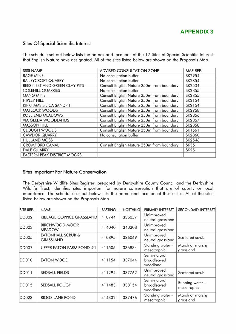
APPENDIX 3 Sites Of Special Scientific Interest The schedule set out below lists the names and locations of the 17 Sites of Special Scientific Interest that English Nature have designated. All of the sites listed below are shown on the Proposals Map. SSSI NAME ADVISED CONSULTATION ZONE MAP REF. BAGE MINE No consultation buffer SK2954 BAILEYCROFT QUARRY No consultation buffer SK2854 BEES NEST AND GREEN CLAY PITS Consult English Nature 250m from boundary SK2534 COLEHILL QUARRIES No consultation buffer SK2855 GANG MINE Consult English Nature 250m from boundary SK2855 HIPLEY HILL Consult English Nature 250m from boundary SK2154 KIRKHAMS SILICA SANDPIT Consult English Nature 250m from boundary SK2154 MATLOCK WOODS Consult English Nature 250m from boundary SK2958 ROSE END MEADOWS Consult English Nature 250m from boundary SK2856 VIA GELLIA WOODLANDS Consult English Nature 250m from boundary SK2857 MASSON HILL Consult English Nature 250m from boundary SK2858 CLOUGH WOODS Consult English Nature 250m from boundary SK1561 CAWDOR QUARRY No consultation buffer SK2860 HULLAND MOSS SK2546 CROMFORD CANAL Consult English Nature 250m from boundary SK35 DALE QUARRY SK25 EASTERN PEAK DISTRICT MOORS Sites Important For Nature Conservation The Derbyshire Wildlife Sites Register, prepared by Derbyshire County Council and the Derbyshire Wildlife Trust, identifies sites important for nature conservation that are of county or local importance. The schedule set out below lists the name and location of these sites. All of the sites listed below are shown on the Proposals Map.
SITE REF. NAME EASTING NORTHING PRIMARY INTEREST SECONDARY INTEREST
DD002 KIBBAGE COPPICE GRASSLAND 410744 335057 Unimproved neutral grassland
DD003 BIRCHWOOD MOOR MEADOW 414040 340308 Unimproved
neutral grassland
DD005 EATONHALL SCRUB & GRASSLAND 410895 336069 Unimproved
neutral grassland Scattered scrub
DD007 UPPER EATON FARM POND #1 411505 336884 Standing water - mesotrophic
Marsh or marshy grassland
DD010 EATON WOOD 411154 337044 Semi-natural broadleaved woodland
DD011 SEDSALL FIELDS 411294 337762 Unimproved neutral grassland Scattered scrub
DD015 SEDSALL ROUGH 411483 338154 Semi-natural broadleaved woodland
Running water - mesotrophic
DD023 RIGGS LANE POND 414332 337476 Standing water - mesotrophic
Marsh or marshy grassland
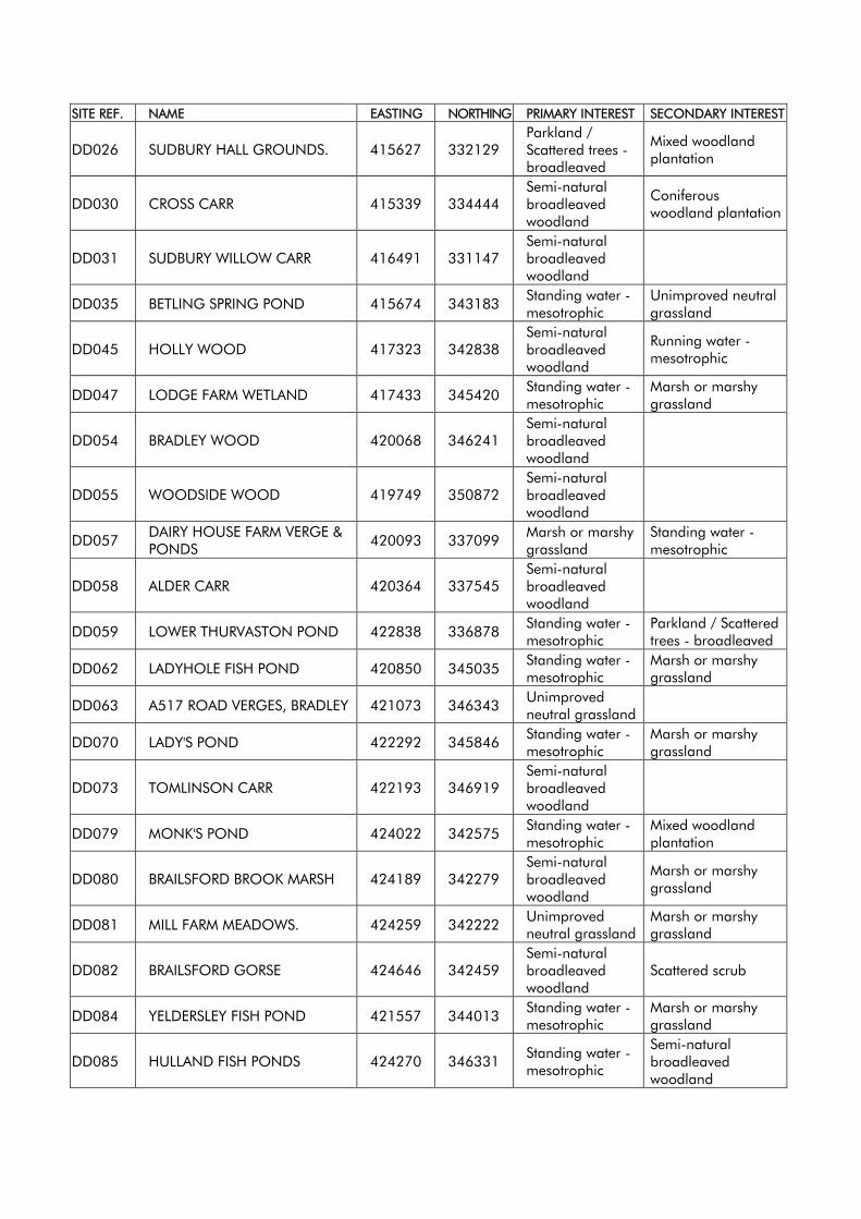
SITE REF. NAME EASTING NORTHING PRIMARY INTEREST SECONDARY INTEREST
DD026 SUDBURY HALL GROUNDS. 415627 332129 Parkland / Scattered trees - broadleaved
Mixed woodland plantation
DD030 CROSS CARR 415339 334444 Semi-natural broadleaved woodland
Coniferous woodland plantation
DD031 SUDBURY WILLOW CARR 416491 331147 Semi-natural broadleaved woodland
DD035 BETLING SPRING POND 415674 343183 Standing water - mesotrophic
Unimproved neutral grassland
DD045 HOLLY WOOD 417323 342838 Semi-natural broadleaved woodland
Running water - mesotrophic
DD047 LODGE FARM WETLAND 417433 345420 Standing water - mesotrophic
Marsh or marshy grassland
DD054 BRADLEY WOOD 420068 346241 Semi-natural broadleaved woodland
DD055 WOODSIDE WOOD 419749 350872 Semi-natural broadleaved woodland
DD057 DAIRY HOUSE FARM VERGE & PONDS 420093 337099 Marsh or marshy
grassland Standing water - mesotrophic
DD058 ALDER CARR 420364 337545 Semi-natural broadleaved woodland
DD059 LOWER THURVASTON POND 422838 336878 Standing water - mesotrophic
Parkland / Scattered trees - broadleaved
DD062 LADYHOLE FISH POND 420850 345035 Standing water - mesotrophic
Marsh or marshy grassland
DD063 A517 ROAD VERGES, BRADLEY 421073 346343 Unimproved neutral grassland
DD070 LADY'S POND 422292 345846 Standing water - mesotrophic
Marsh or marshy grassland
DD073 TOMLINSON CARR 422193 346919 Semi-natural broadleaved woodland
DD079 MONK'S POND 424022 342575 Standing water - mesotrophic
Mixed woodland plantation
DD080 BRAILSFORD BROOK MARSH 424189 342279 Semi-natural broadleaved woodland
Marsh or marshy grassland
DD081 MILL FARM MEADOWS. 424259 342222 Unimproved neutral grassland
Marsh or marshy grassland
DD082 BRAILSFORD GORSE 424646 342459 Semi-natural broadleaved woodland
Scattered scrub
DD084 YELDERSLEY FISH POND 421557 344013 Standing water - mesotrophic
Marsh or marshy grassland
DD085 HULLAND FISH PONDS 424270 346331 Standing water - mesotrophic
Semi-natural broadleaved woodland
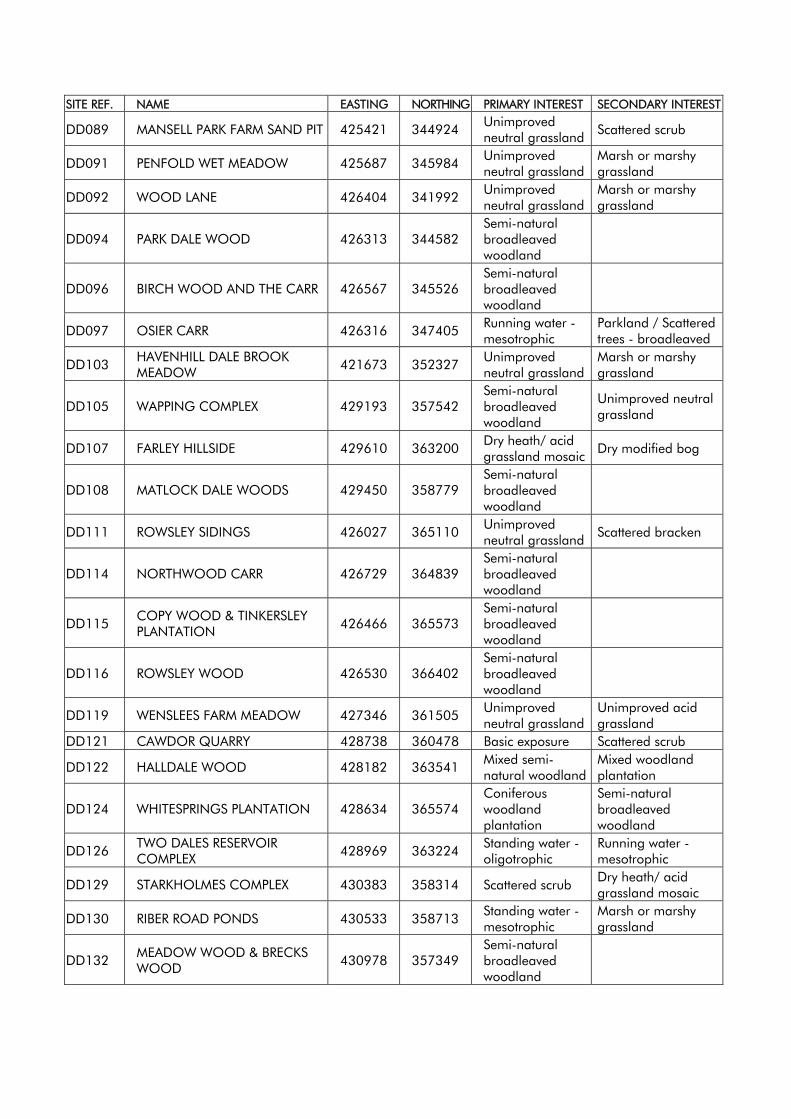
SITE REF. NAME EASTING NORTHING PRIMARY INTEREST SECONDARY INTEREST
DD089 MANSELL PARK FARM SAND PIT 425421 344924 Unimproved neutral grassland Scattered scrub
DD091 PENFOLD WET MEADOW 425687 345984 Unimproved neutral grassland
Marsh or marshy grassland
DD092 WOOD LANE 426404 341992 Unimproved neutral grassland
Marsh or marshy grassland
DD094 PARK DALE WOOD 426313 344582 Semi-natural broadleaved woodland
DD096 BIRCH WOOD AND THE CARR 426567 345526 Semi-natural broadleaved woodland
DD097 OSIER CARR 426316 347405 Running water - mesotrophic
Parkland / Scattered trees - broadleaved
DD103 HAVENHILL DALE BROOK MEADOW 421673 352327 Unimproved
neutral grassland Marsh or marshy grassland
DD105 WAPPING COMPLEX 429193 357542 Semi-natural broadleaved woodland
Unimproved neutral grassland
DD107 FARLEY HILLSIDE 429610 363200 Dry heath/ acid grassland mosaic Dry modified bog
DD108 MATLOCK DALE WOODS 429450 358779 Semi-natural broadleaved woodland
DD111 ROWSLEY SIDINGS 426027 365110 Unimproved neutral grassland Scattered bracken
DD114 NORTHWOOD CARR 426729 364839 Semi-natural broadleaved woodland
DD115 COPY WOOD & TINKERSLEY PLANTATION 426466 365573
Semi-natural broadleaved woodland
DD116 ROWSLEY WOOD 426530 366402 Semi-natural broadleaved woodland
DD119 WENSLEES FARM MEADOW 427346 361505 Unimproved neutral grassland
Unimproved acid grassland
DD121 CAWDOR QUARRY 428738 360478 Basic exposure Scattered scrub
DD122 HALLDALE WOOD 428182 363541 Mixed semi-natural woodland
Mixed woodland plantation
DD124 WHITESPRINGS PLANTATION 428634 365574 Coniferous woodland plantation
Semi-natural broadleaved woodland
DD126 TWO DALES RESERVOIR COMPLEX 428969 363224 Standing water -
oligotrophic Running water - mesotrophic
DD129 STARKHOLMES COMPLEX 430383 358314 Scattered scrub Dry heath/ acid grassland mosaic
DD130 RIBER ROAD PONDS 430533 358713 Standing water - mesotrophic
Marsh or marshy grassland
DD132 MEADOW WOOD & BRECKS WOOD 430978 357349
Semi-natural broadleaved woodland
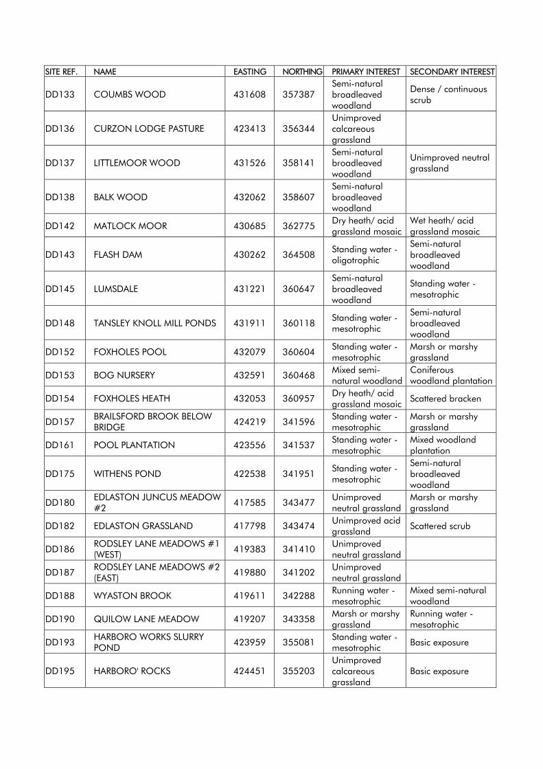
SITE REF. NAME EASTING NORTHING PRIMARY INTEREST SECONDARY INTEREST
DD133 COUMBS WOOD 431608 357387 Semi-natural broadleaved woodland
Dense / continuous scrub
DD136 CURZON LODGE PASTURE 423413 356344 Unimproved calcareous grassland
DD137 LITTLEMOOR WOOD 431526 358141 Semi-natural broadleaved woodland
Unimproved neutral grassland
DD138 BALK WOOD 432062 358607 Semi-natural broadleaved woodland
DD142 MATLOCK MOOR 430685 362775 Dry heath/ acid grassland mosaic
Wet heath/ acid grassland mosaic
DD143 FLASH DAM 430262 364508 Standing water - oligotrophic
Semi-natural broadleaved woodland
DD145 LUMSDALE 431221 360647 Semi-natural broadleaved woodland
Standing water - mesotrophic
DD148 TANSLEY KNOLL MILL PONDS 431911 360118 Standing water - mesotrophic
Semi-natural broadleaved woodland
DD152 FOXHOLES POOL 432079 360604 Standing water - mesotrophic
Marsh or marshy grassland
DD153 BOG NURSERY 432591 360468 Mixed semi-natural woodland
Coniferous woodland plantation
DD154 FOXHOLES HEATH 432053 360957 Dry heath/ acid grassland mosaic Scattered bracken
DD157 BRAILSFORD BROOK BELOW BRIDGE 424219 341596 Standing water -
mesotrophic Marsh or marshy grassland
DD161 POOL PLANTATION 423556 341537 Standing water - mesotrophic
Mixed woodland plantation
DD175 WITHENS POND 422538 341951 Standing water - mesotrophic
Semi-natural broadleaved woodland
DD180 EDLASTON JUNCUS MEADOW #2 417585 343477 Unimproved
neutral grassland Marsh or marshy grassland
DD182 EDLASTON GRASSLAND 417798 343474 Unimproved acid grassland Scattered scrub
DD186 RODSLEY LANE MEADOWS #1 (WEST) 419383 341410 Unimproved
neutral grassland
DD187 RODSLEY LANE MEADOWS #2 (EAST) 419880 341202 Unimproved
neutral grassland
DD188 WYASTON BROOK 419611 342288 Running water - mesotrophic
Mixed semi-natural woodland
DD190 QUILOW LANE MEADOW 419207 343358 Marsh or marshy grassland
Running water - mesotrophic
DD193 HARBORO WORKS SLURRY POND 423959 355081 Standing water -
mesotrophic Basic exposure
DD195 HARBORO' ROCKS 424451 355203 Unimproved calcareous grassland
Basic exposure
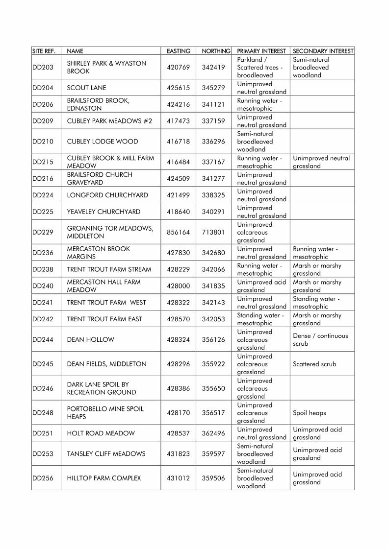
SITE REF. NAME EASTING NORTHING PRIMARY INTEREST SECONDARY INTEREST
DD203 SHIRLEY PARK & WYASTON BROOK 420769 342419
Parkland / Scattered trees - broadleaved
Semi-natural broadleaved woodland
DD204 SCOUT LANE 425615 345279 Unimproved neutral grassland
DD206 BRAILSFORD BROOK, EDNASTON 424216 341121 Running water -
mesotrophic
DD209 CUBLEY PARK MEADOWS #2 417473 337159 Unimproved neutral grassland
DD210 CUBLEY LODGE WOOD 416718 336296 Semi-natural broadleaved woodland
DD215 CUBLEY BROOK & MILL FARM MEADOW 416484 337167 Running water -
mesotrophic Unimproved neutral grassland
DD216 BRAILSFORD CHURCH GRAVEYARD 424509 341277 Unimproved
neutral grassland
DD224 LONGFORD CHURCHYARD 421499 338325 Unimproved neutral grassland
DD225 YEAVELEY CHURCHYARD 418640 340291 Unimproved neutral grassland
DD229 GROANING TOR MEADOWS, MIDDLETON 856164 713801
Unimproved calcareous grassland
DD236 MERCASTON BROOK MARGINS 427830 342680 Unimproved
neutral grassland Running water - mesotrophic
DD238 TRENT TROUT FARM STREAM 428229 342066 Running water - mesotrophic
Marsh or marshy grassland
DD240 MERCASTON HALL FARM MEADOW 428000 341835 Unimproved acid
grassland Marsh or marshy grassland
DD241 TRENT TROUT FARM WEST 428322 342143 Unimproved neutral grassland
Standing water - mesotrophic
DD242 TRENT TROUT FARM EAST 428570 342053 Standing water - mesotrophic
Marsh or marshy grassland
DD244 DEAN HOLLOW 428324 356126 Unimproved calcareous grassland
Dense / continuous scrub
DD245 DEAN FIELDS, MIDDLETON 428296 355922 Unimproved calcareous grassland
Scattered scrub
DD246 DARK LANE SPOIL BY RECREATION GROUND 428386 355650
Unimproved calcareous grassland
DD248 PORTOBELLO MINE SPOIL HEAPS 428170 356517
Unimproved calcareous grassland
Spoil heaps
DD251 HOLT ROAD MEADOW 428537 362496 Unimproved neutral grassland
Unimproved acid grassland
DD253 TANSLEY CLIFF MEADOWS 431823 359597 Semi-natural broadleaved woodland
Unimproved acid grassland
DD256 HILLTOP FARM COMPLEX 431012 359506 Semi-natural broadleaved woodland
Unimproved acid grassland
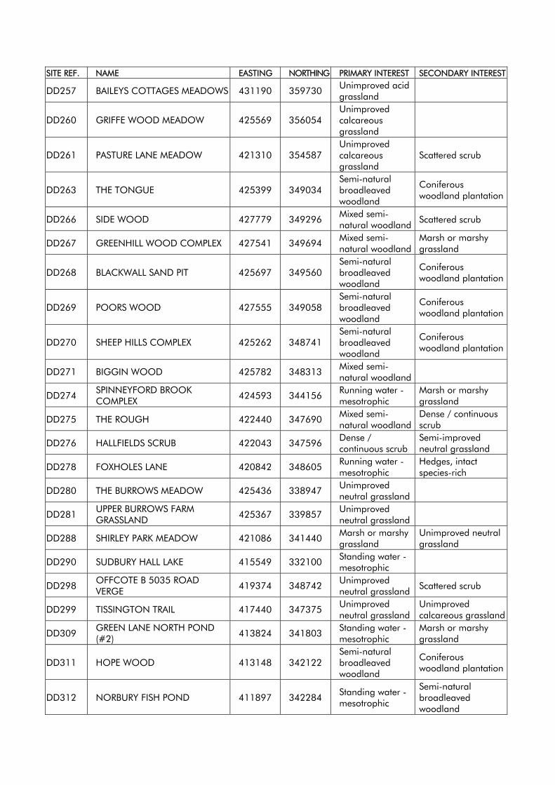
SITE REF. NAME EASTING NORTHING PRIMARY INTEREST SECONDARY INTEREST
DD257 BAILEYS COTTAGES MEADOWS 431190 359730 Unimproved acid grassland
DD260 GRIFFE WOOD MEADOW 425569 356054 Unimproved calcareous grassland
DD261 PASTURE LANE MEADOW 421310 354587 Unimproved calcareous grassland
Scattered scrub
DD263 THE TONGUE 425399 349034 Semi-natural broadleaved woodland
Coniferous woodland plantation
DD266 SIDE WOOD 427779 349296 Mixed semi-natural woodland Scattered scrub
DD267 GREENHILL WOOD COMPLEX 427541 349694 Mixed semi-natural woodland
Marsh or marshy grassland
DD268 BLACKWALL SAND PIT 425697 349560 Semi-natural broadleaved woodland
Coniferous woodland plantation
DD269 POORS WOOD 427555 349058 Semi-natural broadleaved woodland
Coniferous woodland plantation
DD270 SHEEP HILLS COMPLEX 425262 348741 Semi-natural broadleaved woodland
Coniferous woodland plantation
DD271 BIGGIN WOOD 425782 348313 Mixed semi-natural woodland
DD274 SPINNEYFORD BROOK COMPLEX 424593 344156 Running water -
mesotrophic Marsh or marshy grassland
DD275 THE ROUGH 422440 347690 Mixed semi-natural woodland
Dense / continuous scrub
DD276 HALLFIELDS SCRUB 422043 347596 Dense / continuous scrub
Semi-improved neutral grassland
DD278 FOXHOLES LANE 420842 348605 Running water - mesotrophic
Hedges, intact species-rich
DD280 THE BURROWS MEADOW 425436 338947 Unimproved neutral grassland
DD281 UPPER BURROWS FARM GRASSLAND 425367 339857 Unimproved
neutral grassland
DD288 SHIRLEY PARK MEADOW 421086 341440 Marsh or marshy grassland
Unimproved neutral grassland
DD290 SUDBURY HALL LAKE 415549 332100 Standing water - mesotrophic
DD298 OFFCOTE B 5035 ROAD VERGE 419374 348742 Unimproved
neutral grassland Scattered scrub
DD299 TISSINGTON TRAIL 417440 347375 Unimproved neutral grassland
Unimproved calcareous grassland
DD309 GREEN LANE NORTH POND (#2) 413824 341803 Standing water -
mesotrophic Marsh or marshy grassland
DD311 HOPE WOOD 413148 342122 Semi-natural broadleaved woodland
Coniferous woodland plantation
DD312 NORBURY FISH POND 411897 342284 Standing water - mesotrophic
Semi-natural broadleaved woodland
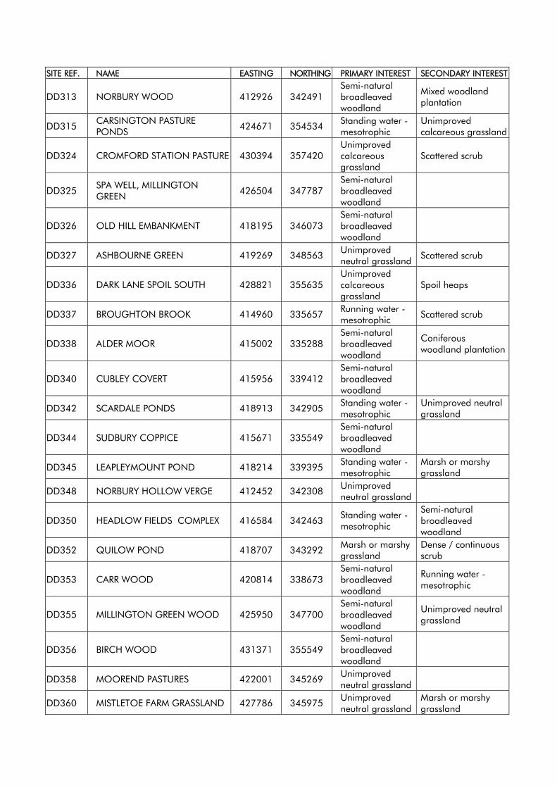
SITE REF. NAME EASTING NORTHING PRIMARY INTEREST SECONDARY INTEREST
DD313 NORBURY WOOD 412926 342491 Semi-natural broadleaved woodland
Mixed woodland plantation
DD315 CARSINGTON PASTURE PONDS 424671 354534 Standing water -
mesotrophic Unimproved calcareous grassland
DD324 CROMFORD STATION PASTURE 430394 357420 Unimproved calcareous grassland
Scattered scrub
DD325 SPA WELL, MILLINGTON GREEN 426504 347787
Semi-natural broadleaved woodland
DD326 OLD HILL EMBANKMENT 418195 346073 Semi-natural broadleaved woodland
DD327 ASHBOURNE GREEN 419269 348563 Unimproved neutral grassland Scattered scrub
DD336 DARK LANE SPOIL SOUTH 428821 355635 Unimproved calcareous grassland
Spoil heaps
DD337 BROUGHTON BROOK 414960 335657 Running water - mesotrophic Scattered scrub
DD338 ALDER MOOR 415002 335288 Semi-natural broadleaved woodland
Coniferous woodland plantation
DD340 CUBLEY COVERT 415956 339412 Semi-natural broadleaved woodland
DD342 SCARDALE PONDS 418913 342905 Standing water - mesotrophic
Unimproved neutral grassland
DD344 SUDBURY COPPICE 415671 335549 Semi-natural broadleaved woodland
DD345 LEAPLEYMOUNT POND 418214 339395 Standing water - mesotrophic
Marsh or marshy grassland
DD348 NORBURY HOLLOW VERGE 412452 342308 Unimproved neutral grassland
DD350 HEADLOW FIELDS COMPLEX 416584 342463 Standing water - mesotrophic
Semi-natural broadleaved woodland
DD352 QUILOW POND 418707 343292 Marsh or marshy grassland
Dense / continuous scrub
DD353 CARR WOOD 420814 338673 Semi-natural broadleaved woodland
Running water - mesotrophic
DD355 MILLINGTON GREEN WOOD 425950 347700 Semi-natural broadleaved woodland
Unimproved neutral grassland
DD356 BIRCH WOOD 431371 355549 Semi-natural broadleaved woodland
DD358 MOOREND PASTURES 422001 345269 Unimproved neutral grassland
DD360 MISTLETOE FARM GRASSLAND 427786 345975 Unimproved neutral grassland
Marsh or marshy grassland
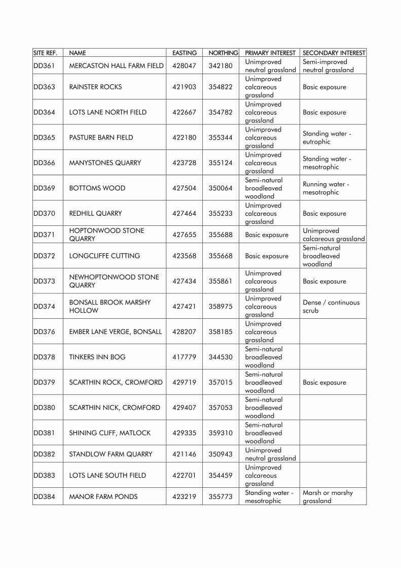
SITE REF. NAME EASTING NORTHING PRIMARY INTEREST SECONDARY INTEREST
DD361 MERCASTON HALL FARM FIELD 428047 342180 Unimproved neutral grassland
Semi-improved neutral grassland
DD363 RAINSTER ROCKS 421903 354822 Unimproved calcareous grassland
Basic exposure
DD364 LOTS LANE NORTH FIELD 422667 354782 Unimproved calcareous grassland
Basic exposure
DD365 PASTURE BARN FIELD 422180 355344 Unimproved calcareous grassland
Standing water - eutrophic
DD366 MANYSTONES QUARRY 423728 355124 Unimproved calcareous grassland
Standing water - mesotrophic
DD369 BOTTOMS WOOD 427504 350064 Semi-natural broadleaved woodland
Running water - mesotrophic
DD370 REDHILL QUARRY 427464 355233 Unimproved calcareous grassland
Basic exposure
DD371 HOPTONWOOD STONE QUARRY 427655 355688 Basic exposure Unimproved
calcareous grassland
DD372 LONGCLIFFE CUTTING 423568 355668 Basic exposure Semi-natural broadleaved woodland
DD373 NEWHOPTONWOOD STONE QUARRY 427434 355861
Unimproved calcareous grassland
Basic exposure
DD374 BONSALL BROOK MARSHY HOLLOW 427421 358975
Unimproved calcareous grassland
Dense / continuous scrub
DD376 EMBER LANE VERGE, BONSALL 428207 358185 Unimproved calcareous grassland
DD378 TINKERS INN BOG 417779 344530 Semi-natural broadleaved woodland
DD379 SCARTHIN ROCK, CROMFORD 429719 357015 Semi-natural broadleaved woodland
Basic exposure
DD380 SCARTHIN NICK, CROMFORD 429407 357053 Semi-natural broadleaved woodland
DD381 SHINING CLIFF, MATLOCK 429335 359310 Semi-natural broadleaved woodland
DD382 STANDLOW FARM QUARRY 421146 350943 Unimproved neutral grassland
DD383 LOTS LANE SOUTH FIELD 422701 354459 Unimproved calcareous grassland
DD384 MANOR FARM PONDS 423219 355773 Standing water - mesotrophic
Marsh or marshy grassland
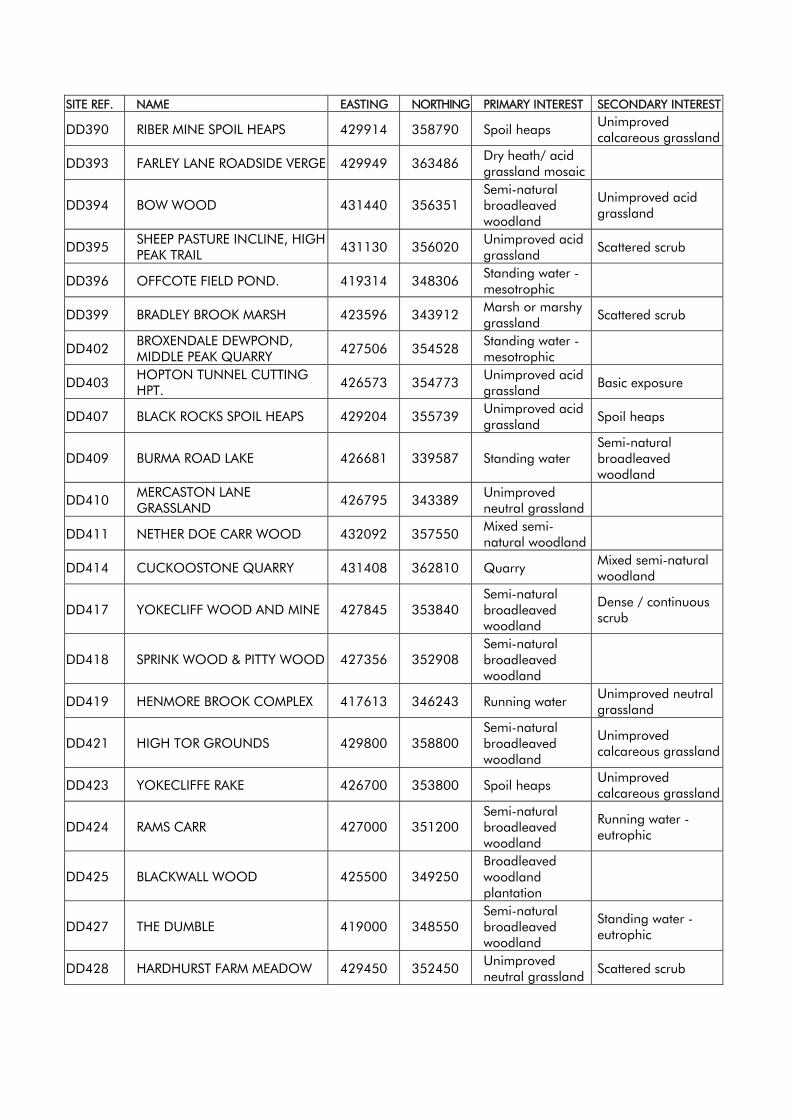
SITE REF. NAME EASTING NORTHING PRIMARY INTEREST SECONDARY INTEREST
DD390 RIBER MINE SPOIL HEAPS 429914 358790 Spoil heaps Unimproved calcareous grassland
DD393 FARLEY LANE ROADSIDE VERGE 429949 363486 Dry heath/ acid grassland mosaic
DD394 BOW WOOD 431440 356351 Semi-natural broadleaved woodland
Unimproved acid grassland
DD395 SHEEP PASTURE INCLINE, HIGH PEAK TRAIL 431130 356020 Unimproved acid
grassland Scattered scrub
DD396 OFFCOTE FIELD POND. 419314 348306 Standing water - mesotrophic
DD399 BRADLEY BROOK MARSH 423596 343912 Marsh or marshy grassland Scattered scrub
DD402 BROXENDALE DEWPOND, MIDDLE PEAK QUARRY 427506 354528 Standing water -
mesotrophic
DD403 HOPTON TUNNEL CUTTING HPT. 426573 354773 Unimproved acid
grassland Basic exposure
DD407 BLACK ROCKS SPOIL HEAPS 429204 355739 Unimproved acid grassland Spoil heaps
DD409 BURMA ROAD LAKE 426681 339587 Standing water Semi-natural broadleaved woodland
DD410 MERCASTON LANE GRASSLAND 426795 343389 Unimproved
neutral grassland
DD411 NETHER DOE CARR WOOD 432092 357550 Mixed semi-natural woodland
DD414 CUCKOOSTONE QUARRY 431408 362810 Quarry Mixed semi-natural woodland
DD417 YOKECLIFF WOOD AND MINE 427845 353840 Semi-natural broadleaved woodland
Dense / continuous scrub
DD418 SPRINK WOOD & PITTY WOOD 427356 352908 Semi-natural broadleaved woodland
DD419 HENMORE BROOK COMPLEX 417613 346243 Running water Unimproved neutral grassland
DD421 HIGH TOR GROUNDS 429800 358800 Semi-natural broadleaved woodland
Unimproved calcareous grassland
DD423 YOKECLIFFE RAKE 426700 353800 Spoil heaps Unimproved calcareous grassland
DD424 RAMS CARR 427000 351200 Semi-natural broadleaved woodland
Running water - eutrophic
DD425 BLACKWALL WOOD 425500 349250 Broadleaved woodland plantation
DD427 THE DUMBLE 419000 348550 Semi-natural broadleaved woodland
Standing water - eutrophic
DD428 HARDHURST FARM MEADOW 429450 352450 Unimproved neutral grassland Scattered scrub
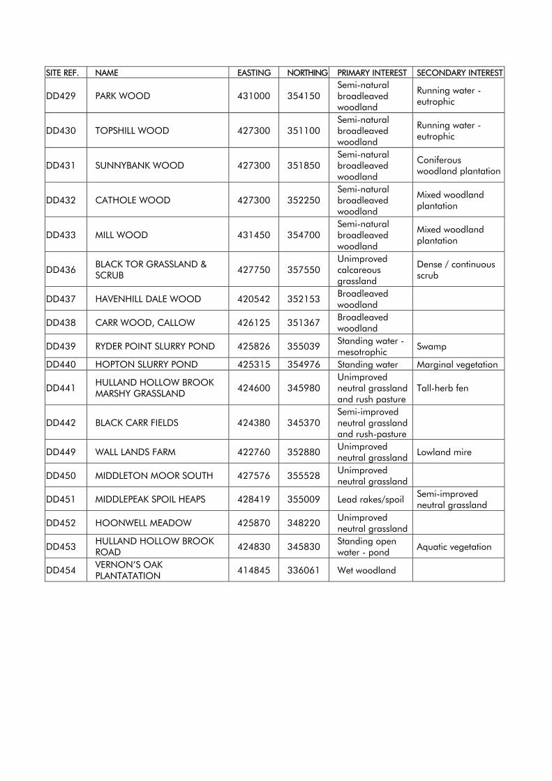
SITE REF. NAME EASTING NORTHING PRIMARY INTEREST SECONDARY INTEREST
DD429 PARK WOOD 431000 354150 Semi-natural broadleaved woodland
Running water - eutrophic
DD430 TOPSHILL WOOD 427300 351100 Semi-natural broadleaved woodland
Running water - eutrophic
DD431 SUNNYBANK WOOD 427300 351850 Semi-natural broadleaved woodland
Coniferous woodland plantation
DD432 CATHOLE WOOD 427300 352250 Semi-natural broadleaved woodland
Mixed woodland plantation
DD433 MILL WOOD 431450 354700 Semi-natural broadleaved woodland
Mixed woodland plantation
DD436 BLACK TOR GRASSLAND & SCRUB 427750 357550
Unimproved calcareous grassland
Dense / continuous scrub
DD437 HAVENHILL DALE WOOD 420542 352153 Broadleaved woodland
DD438 CARR WOOD, CALLOW 426125 351367 Broadleaved woodland
DD439 RYDER POINT SLURRY POND 425826 355039 Standing water - mesotrophic Swamp
DD440 HOPTON SLURRY POND 425315 354976 Standing water Marginal vegetation
DD441 HULLAND HOLLOW BROOK MARSHY GRASSLAND 424600 345980
Unimproved neutral grassland and rush pasture
Tall-herb fen
DD442 BLACK CARR FIELDS 424380 345370 Semi-improved neutral grassland and rush-pasture
DD449 WALL LANDS FARM 422760 352880 Unimproved neutral grassland Lowland mire
DD450 MIDDLETON MOOR SOUTH 427576 355528 Unimproved neutral grassland
DD451 MIDDLEPEAK SPOIL HEAPS 428419 355009 Lead rakes/spoil Semi-improved neutral grassland
DD452 HOONWELL MEADOW 425870 348220 Unimproved neutral grassland
DD453 HULLAND HOLLOW BROOK ROAD 424830 345830 Standing open
water - pond Aquatic vegetation
DD454 VERNON’S OAK PLANTATATION 414845 336061 Wet woodland
APPENDIX 4 Car Parking Guidelines
PPG13 states that the availability of car parking has a major influence on the means of transport people choose for their journeys, therefore appropriate car parking policies are necessary. The Guidance states that for new developments maximum levels of car parking provision should be set for broad land use classes and location. The Derbyshire Dales are characterised by market towns and scattered villages, many with limited shops and services. As such the car often remains the only realistic choice for many journeys. In some locations, such as the market towns where there is a choice of transport modes and good access to local services, reduced levels of parking may be acceptable. The Council will generally require parking provision to be provided clear of the highway. On street parking can be detrimental to road safety as well as having a negative impact upon the character and appearance of an area. The maximum standards will therefore be applied in a manner such that they do not create or exacerbate local highway problems. Dimensions for Parking and Turning
Car parking spaces shall have minimum dimensions of 4.8 metres by 2.4 metres unless they are for the specific use of disabled people. Except in special circumstances the longitudinal gradient of parking spaces shall not exceed 1 in 14 and the crossfall shall not exceed 1 in 40. Garages should normally be set back at least 6 metres from the limit of the subject access frontage. In all developments serviced by commercial vehicles, and elsewhere as required by the Highway Authority, there should be facilities for vehicles to turn within the site which are separate from the parking spaces. It will not be acceptable for vehicles to park or wait within these turning areas. Commuted Payments
In accordance with the provisions of Policy TR7, the Council will seek to negotiate a Section 106 Obligation to finance the provision of car parking at an available nearby location where the minimum operational amount of parking cannot be provided on-site.
Provision for Motorcycles and Mopeds
Adequate motorcycle and moped parking should be provided in new developments where appropriate, or where a Travel Plan has identified motorbikes and mopeds as a viable alternative to the car.
Provision for Cyclists
Adequate cycle parking should be provided at all centres of education, leisure establishments, shopping centres, public transport interchanges and places of employment. All new developments over 100m² should provide a minimum of three secure bicycle parking spaces. For developments of 1000m² and above, the minimum provision of cycle spaces is 5% of the maximum parking provision for cars. Cycle parking facilities should be accessible and secure and should be provided on-site in a position that is regularly observed. Disabled Parking The Council will seek a proportion of parking spaces for disabled people in accordance with Traffic Advisory Leaflet 5/95 The Guidelines
Set out below are the maximum amounts of parking required by various forms of development. Any land uses or types of development not specifically mentioned will be considered on an individual and site-specific basis, as will combinations of types of developments. All stated areas are gross inclusive floor areas, measured externally, unless otherwise referred to, (e.g. dining area). Where appraisals of parking need are based on the numbers of staff, these shall be the maximum possible number on duty at any one time rather than the total number employed.
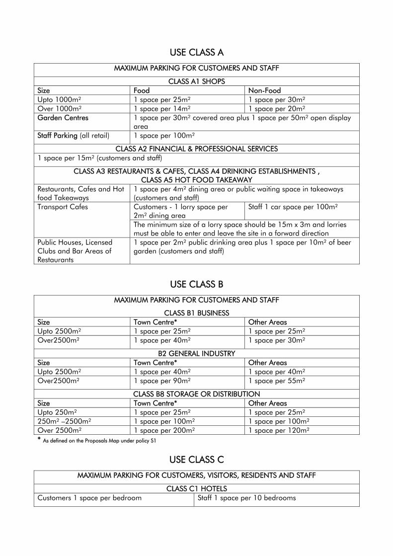
USE CLASS A
MAXIMUM PARKING FOR CUSTOMERS AND STAFF
CLASS A1 SHOPS Size Food Non-Food Upto 1000m² 1 space per 25m² 1 space per 30m² Over 1000m² 1 space per 14m² 1 space per 20m² Garden Centres 1 space per 30m² covered area plus 1 space per 50m² open display
area Staff Parking (all retail) 1 space per 100m²
CLASS A2 FINANCIAL & PROFESSIONAL SERVICES 1 space per 15m² (customers and staff)
CLASS A3 RESTAURANTS & CAFES, CLASS A4 DRINKING ESTABLISHMENTS , CLASS A5 HOT FOOD TAKEAWAY
Restaurants, Cafes and Hot food Takeaways
1 space per 4m² dining area or public waiting space in takeaways (customers and staff) Customers - 1 lorry space per 2m² dining area
Staff 1 car space per 100m² Transport Cafes
The minimum size of a lorry space should be 15m x 3m and lorries must be able to enter and leave the site in a forward direction
Public Houses, Licensed Clubs and Bar Areas of Restaurants
1 space per 2m² public drinking area plus 1 space per 10m² of beer garden (customers and staff)
USE CLASS B
MAXIMUM PARKING FOR CUSTOMERS AND STAFF
CLASS B1 BUSINESS Size Town Centre* Other Areas Upto 2500m² 1 space per 25m² 1 space per 25m² Over2500m² 1 space per 40m² 1 space per 30m²
B2 GENERAL INDUSTRY Size Town Centre* Other Areas Upto 2500m² 1 space per 40m² 1 space per 40m² Over2500m² 1 space per 90m² 1 space per 55m²
CLASS B8 STORAGE OR DISTRIBUTION Size Town Centre* Other Areas Upto 250m² 1 space per 25m² 1 space per 25m² 250m² –2500m² 1 space per 100m² 1 space per 100m² Over 2500m² 1 space per 200m² 1 space per 120m² * As defined on the Proposals Map under policy S1
USE CLASS C
MAXIMUM PARKING FOR CUSTOMERS, VISITORS, RESIDENTS AND STAFF
CLASS C1 HOTELS Customers 1 space per bedroom Staff 1 space per 10 bedrooms
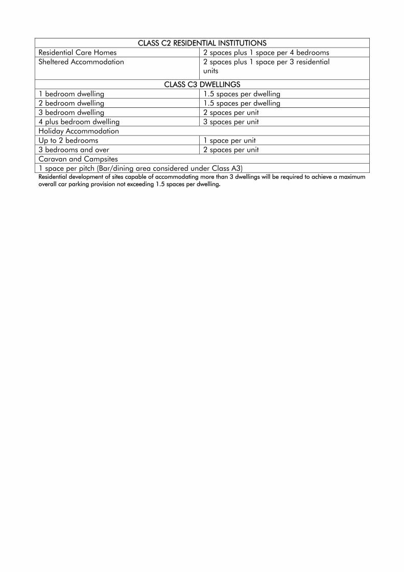
CLASS C2 RESIDENTIAL INSTITUTIONS Residential Care Homes 2 spaces plus 1 space per 4 bedrooms Sheltered Accommodation 2 spaces plus 1 space per 3 residential
units
CLASS C3 DWELLINGS 1 bedroom dwelling 1.5 spaces per dwelling 2 bedroom dwelling 1.5 spaces per dwelling 3 bedroom dwelling 2 spaces per unit 4 plus bedroom dwelling 3 spaces per unit Holiday Accommodation Up to 2 bedrooms 1 space per unit 3 bedrooms and over 2 spaces per unit Caravan and Campsites 1 space per pitch (Bar/dining area considered under Class A3) Residential development of sites capable of accommodating more than 3 dwellings will be required to achieve a maximum overall car parking provision not exceeding 1.5 spaces per dwelling.
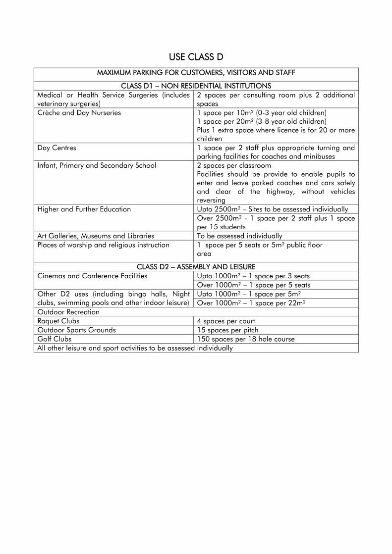
USE CLASS D
MAXIMUM PARKING FOR CUSTOMERS, VISITORS AND STAFF
CLASS D1 – NON RESIDENTIAL INSTITUTIONS Medical or Health Service Surgeries (includes veterinary surgeries)
2 spaces per consulting room plus 2 additional spaces
Crèche and Day Nurseries 1 space per 10m² (0-3 year old children) 1 space per 20m² (3-8 year old children) Plus 1 extra space where licence is for 20 or more children
Day Centres 1 space per 2 staff plus appropriate turning and parking facilities for coaches and minibuses
Infant, Primary and Secondary School 2 spaces per classroom Facilities should be provide to enable pupils to enter and leave parked coaches and cars safely and clear of the highway, without vehicles reversing Upto 2500m² – Sites to be assessed individually Higher and Further Education Over 2500m² - 1 space per 2 staff plus 1 space per 15 students
Art Galleries, Museums and Libraries To be assessed individually Places of worship and religious instruction 1 space per 5 seats or 5m² public floor
area
CLASS D2 – ASSEMBLY AND LEISURE Upto 1000m² – 1 space per 3 seats Cinemas and Conference Facilities Over 1000m² – 1 space per 5 seats Upto 1000m² – 1 space per 5m² Other D2 uses (including bingo halls, Night
clubs, swimming pools and other indoor leisure) Over 1000m² – 1 space per 22m² Outdoor Recreation Raquet Clubs 4 spaces per court Outdoor Sports Grounds 15 spaces per pitch Golf Clubs 150 spaces per 18 hole course All other leisure and sport activities to be assessed individually
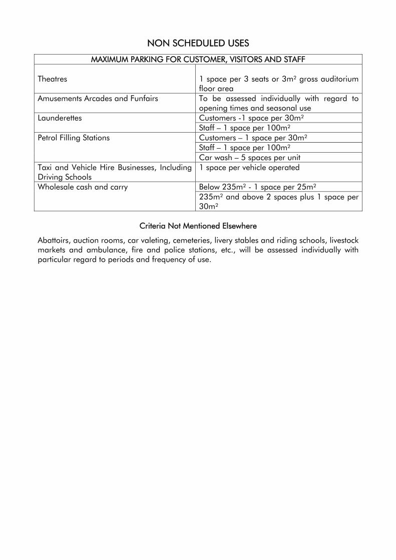
NON SCHEDULED USES
MAXIMUM PARKING FOR CUSTOMER, VISITORS AND STAFF Theatres
1 space per 3 seats or 3m² gross auditorium floor area
Amusements Arcades and Funfairs To be assessed individually with regard to opening times and seasonal use Customers -1 space per 30m² Launderettes Staff – 1 space per 100m² Customers – 1 space per 30m² Staff – 1 space per 100m²
Petrol Filling Stations
Car wash – 5 spaces per unit Taxi and Vehicle Hire Businesses, Including Driving Schools
1 space per vehicle operated
Below 235m² - 1 space per 25m² Wholesale cash and carry 235m² and above 2 spaces plus 1 space per 30m²
Criteria Not Mentioned Elsewhere
Abattoirs, auction rooms, car valeting, cemeteries, livery stables and riding schools, livestock markets and ambulance, fire and police stations, etc., will be assessed individually with particular regard to periods and frequency of use.
APPENDIX 5 Local Plan Corporate Check In June 2003, the Council adopted a new Corporate Plan. This forms the basis for the Council’s plans, strategies and policies. It includes a vision of the Council’s aims for the area, seven core values that support all the Council’s activities, and four main aims in terms of what the Council does and what it hopes to achieve. It also includes a statement of priorities for the period 2003 to 2007. These form the basis upon which the Council focuses its activities. The Council’s Partnership Vision is;
“Working in partnership to keep the Derbyshire Dales one of the
best places in Britain to live, work and visit”
The seven core values that underpin everything the Council does to achieve the vision are;
• Championing rural communities • Fairness and equality • Listening to people • Quality of service • Value for money • Valuing our employees • Working with partners
The purpose of the Council is set out in the four main aims;
• Lead the communities of the Derbyshire Dales • Improve quality of life • Protect and enhance the environment • Provide excellent services
The Council's key objectives for the next four years (2003 – 2007) have been prioritised, and identified by the community and our partners.
To make sure the Council brings about significant improvements, it will concentrate on the following seven priorities:
• Improve the supply of decent, affordable homes for local people • Increase the number of people, especially young people, participating in
leisure activities • Reduce, re-use and recycle waste • Protect and improve the safety and health of residents and visitors • Stimulate economic, community and environmental regeneration • Improve access to services • Support service delivery programme
The Derbyshire Dales Local Plan is one of the tools that the Council can use to deliver the key priorities of the Corporate Plan. The purpose of this Appendix is to identify the extent to which the policies and proposals in the Derbyshire Dales Local Plan assist with delivery of the corporate aims and objectives. The strategic links between the policies and proposals and the corporate aims and objectives have been measured as follows;
✔ Direct Strategic Link
✖ No Direct Strategic Link
✔/✖ Partial Strategic Link
Revised Appendix 3 (ii)
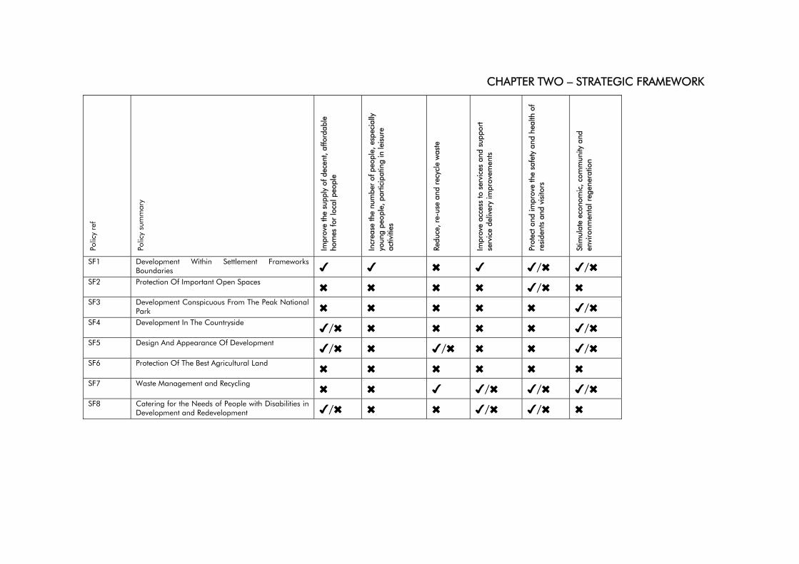
CHAPTER TWO – STRATEGIC FRAMEWORK Po
licy
ref
Polic
y su
mm
ary
Impr
ove
the
supp
ly o
f dec
ent,
affo
rdab
le
hom
es fo
r lo
cal p
eopl
e
Incr
ease
the
num
ber
of p
eopl
e, e
spec
ially
yo
ung
peop
le, p
artic
ipat
ing
in le
isur
e ac
tiviti
es
Redu
ce, r
e-us
e an
d re
cycl
e w
aste
Impr
ove
acce
ss to
ser
vice
s an
d su
ppor
t se
rvic
e de
liver
y im
prov
emen
ts
Prot
ect a
nd im
prov
e th
e sa
fety
and
hea
lth o
f re
side
nts
and
visi
tors
Stim
ulat
e ec
onom
ic, c
omm
unity
and
en
viro
nmen
tal r
egen
erat
ion
SF1 Development Within Settlement Frameworks Boundaries ✔ ✔ ✖ ✔ ✔/✖ ✔/✖
SF2 Protection Of Important Open Spaces ✖ ✖ ✖ ✖ ✔/✖ ✖
SF3 Development Conspicuous From The Peak National Park ✖ ✖ ✖ ✖ ✖ ✔/✖
SF4 Development In The Countryside ✔/✖ ✖ ✖ ✖ ✖ ✔/✖ SF5 Design And Appearance Of Development ✔/✖ ✖ ✔/✖ ✖ ✖ ✔/✖ SF6 Protection Of The Best Agricultural Land ✖ ✖ ✖ ✖ ✖ ✖ SF7 Waste Management and Recycling ✖ ✖ ✔ ✔/✖ ✔/✖ ✔/✖ SF8 Catering for the Needs of People with Disabilities in
Development and Redevelopment ✔/✖ ✖ ✖ ✔/✖ ✔/✖ ✖
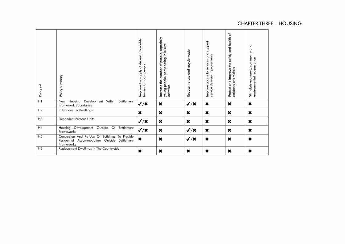
CHAPTER THREE – HOUSING
Polic
y re
f
Polic
y su
mm
ary
Impr
ove
the
supp
ly o
f dec
ent,
affo
rdab
le
hom
es fo
r lo
cal p
eopl
e
Incr
ease
the
num
ber
of p
eopl
e, e
spec
ially
yo
ung
peop
le, p
artic
ipat
ing
in le
isur
e ac
tiviti
es
Redu
ce, r
e-us
e an
d re
cycl
e w
aste
Impr
ove
acce
ss to
ser
vice
s an
d su
ppor
t se
rvic
e de
liver
y im
prov
emen
ts
Prot
ect a
nd im
prov
e th
e sa
fety
and
hea
lth o
f re
side
nts
and
visi
tors
Stim
ulat
e ec
onom
ic, c
omm
unity
and
en
viro
nmen
tal r
egen
erat
ion
H1 New Housing Development Within Settlement Framework Boundaries ✔/✖ ✖ ✔/✖ ✖ ✖ ✖
H2 Extensions To Dwellings ✖ ✖ ✖ ✖ ✖ ✖ H3 Dependent Persons Units ✔/✖ ✖ ✖ ✖ ✖ ✖ H4 Housing Development Outside Of Settlement
Frameworks ✔/✖ ✖ ✔/✖ ✖ ✖ ✖ H5 Conversion And Re-Use Of Buildings To Provide
Residential Accommodation Outside Settlement Frameworks
✖ ✖ ✔/✖ ✖ ✖ ✖
H6 Replacement Dwellings In The Countryside ✖ ✖ ✖ ✖ ✖ ✖
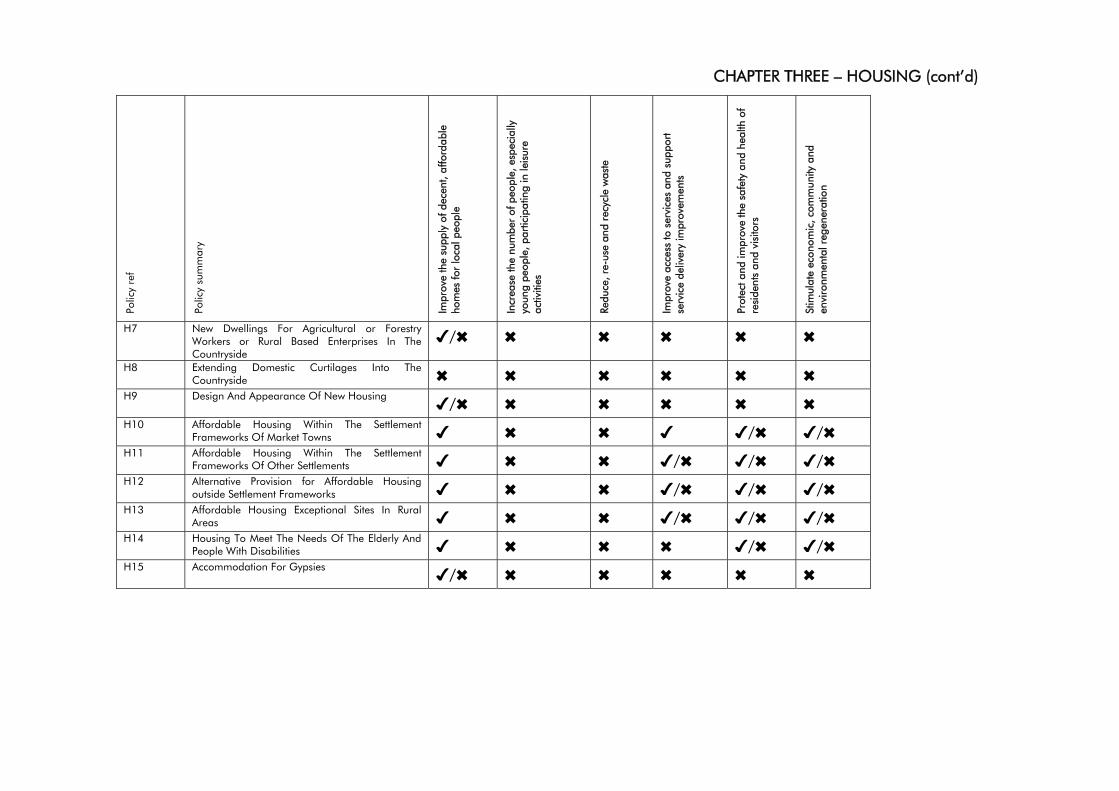
CHAPTER THREE – HOUSING (cont’d)
Polic
y re
f
Polic
y su
mm
ary
Impr
ove
the
supp
ly o
f dec
ent,
affo
rdab
le
hom
es fo
r lo
cal p
eopl
e
Incr
ease
the
num
ber
of p
eopl
e, e
spec
ially
yo
ung
peop
le, p
artic
ipat
ing
in le
isur
e ac
tiviti
es
Redu
ce, r
e-us
e an
d re
cycl
e w
aste
Impr
ove
acce
ss to
ser
vice
s an
d su
ppor
t se
rvic
e de
liver
y im
prov
emen
ts
Prot
ect a
nd im
prov
e th
e sa
fety
and
hea
lth o
f re
side
nts
and
visi
tors
Stim
ulat
e ec
onom
ic, c
omm
unity
and
en
viro
nmen
tal r
egen
erat
ion
H7 New Dwellings For Agricultural or Forestry Workers or Rural Based Enterprises In The Countryside
✔/✖ ✖ ✖ ✖ ✖ ✖
H8 Extending Domestic Curtilages Into The Countryside ✖ ✖ ✖ ✖ ✖ ✖
H9 Design And Appearance Of New Housing ✔/✖ ✖ ✖ ✖ ✖ ✖ H10 Affordable Housing Within The Settlement
Frameworks Of Market Towns ✔ ✖ ✖ ✔ ✔/✖ ✔/✖ H11 Affordable Housing Within The Settlement
Frameworks Of Other Settlements ✔ ✖ ✖ ✔/✖ ✔/✖ ✔/✖ H12 Alternative Provision for Affordable Housing
outside Settlement Frameworks ✔ ✖ ✖ ✔/✖ ✔/✖ ✔/✖ H13 Affordable Housing Exceptional Sites In Rural
Areas ✔ ✖ ✖ ✔/✖ ✔/✖ ✔/✖ H14 Housing To Meet The Needs Of The Elderly And
People With Disabilities ✔ ✖ ✖ ✖ ✔/✖ ✔/✖ H15 Accommodation For Gypsies ✔/✖ ✖ ✖ ✖ ✖ ✖
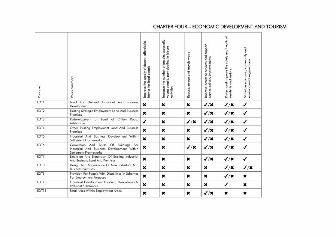
CHAPTER FOUR – ECONOMIC DEVELOPMENT AND TOURISM
Polic
y re
f
Polic
y su
mm
ary
Impr
ove
the
supp
ly o
f dec
ent,
affo
rdab
le
hom
es fo
r lo
cal p
eopl
e
Incr
ease
the
num
ber
of p
eopl
e, e
spec
ially
yo
ung
peop
le, p
artic
ipat
ing
in le
isur
e ac
tiviti
es
Redu
ce, r
e-us
e an
d re
cycl
e w
aste
Impr
ove
acce
ss to
ser
vice
s an
d su
ppor
t se
rvic
e de
liver
y im
prov
emen
ts
Prot
ect a
nd im
prov
e th
e sa
fety
and
hea
lth o
f re
side
nts
and
visi
tors
Stim
ulat
e ec
onom
ic, c
omm
unity
and
en
viro
nmen
tal r
egen
erat
ion
EDT1 Land For General Industrial And Business Development ✖ ✖ ✖ ✔/✖ ✔/✖ ✔
EDT2 Existing Strategic Employment Land And Business Premises ✖ ✖ ✖ ✔/✖ ✔/✖ ✔
EDT3 Redevelopment of Land at Clifton Road, Ashbourne ✔ ✖ ✔/✖ ✔/✖ ✔/✖ ✔
EDT4 Other Existing Employment Land And Business Premises ✖ ✖ ✖ ✔/✖ ✔/✖ ✔
EDT5 Industrial And Business Development Within Settlement Frameworks ✖ ✖ ✖ ✔/✖ ✔/✖ ✔
EDT6 Conversion And Reuse Of Buildings For Industrial And Business Development Within Settlement Frameworks
✖ ✖ ✔/✖ ✔/✖ ✔/✖ ✔
EDT7 Extension And Expansion Of Existing Industrial And Business Land And Premises ✖ ✖ ✖ ✔/✖ ✔/✖ ✔
EDT8 Design And Appearance Of New Industrial And Business Premises ✖ ✖ ✖ ✖ ✔/✖ ✔/✖
EDT9 Provision For People With Disabilities In Schemes For Employment Purposes ✖ ✖ ✖ ✖ ✔/✖ ✖
EDT10 Industrial Development Involving Hazardous Or Pollutant Substances ✖ ✖ ✖ ✖ ✔ ✖
EDT11 Retail Uses Within Employment Areas ✖ ✖ ✖ ✔/✖ ✖ ✖
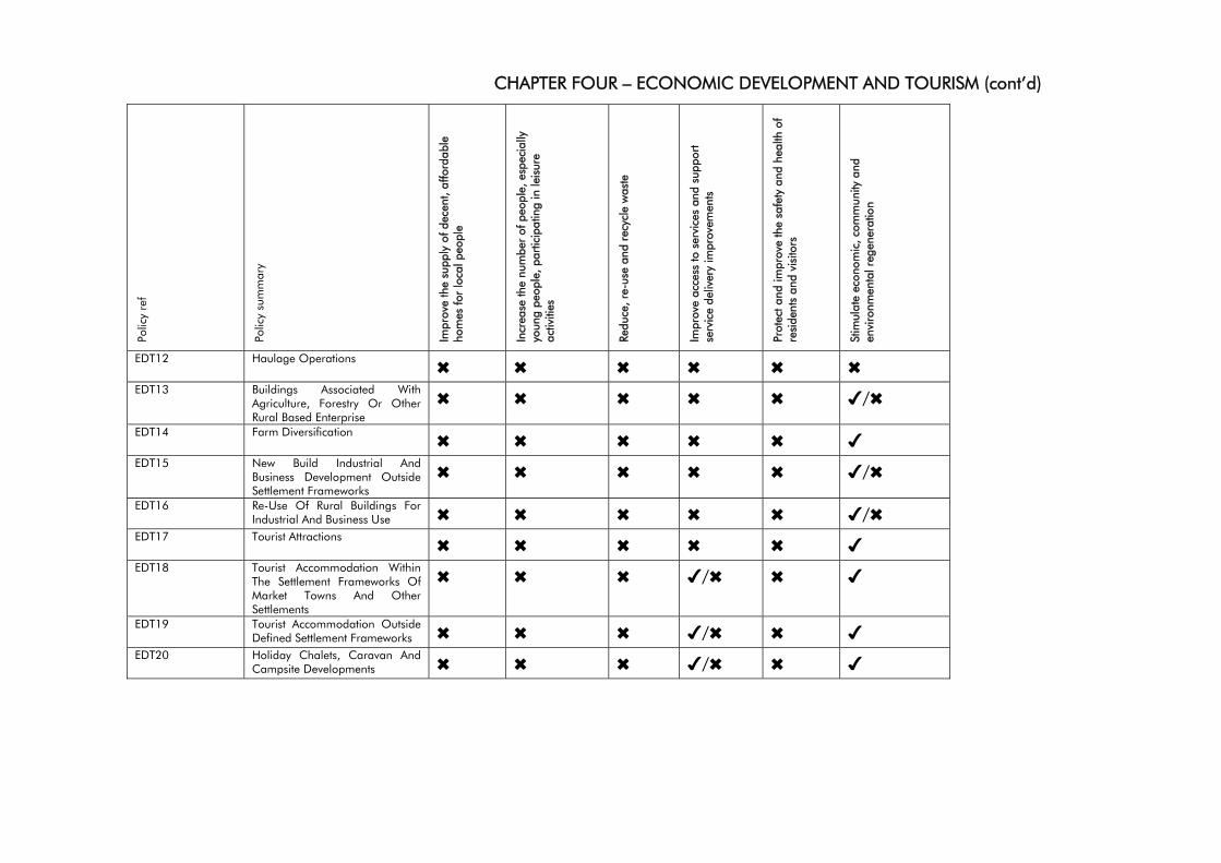
CHAPTER FOUR – ECONOMIC DEVELOPMENT AND TOURISM (cont’d)
Polic
y re
f
Polic
y su
mm
ary
Impr
ove
the
supp
ly o
f dec
ent,
affo
rdab
le
hom
es fo
r lo
cal p
eopl
e
Incr
ease
the
num
ber
of p
eopl
e, e
spec
ially
yo
ung
peop
le, p
artic
ipat
ing
in le
isur
e ac
tiviti
es
Redu
ce, r
e-us
e an
d re
cycl
e w
aste
Impr
ove
acce
ss to
ser
vice
s an
d su
ppor
t se
rvic
e de
liver
y im
prov
emen
ts
Prot
ect a
nd im
prov
e th
e sa
fety
and
hea
lth o
f re
side
nts
and
visi
tors
Stim
ulat
e ec
onom
ic, c
omm
unity
and
en
viro
nmen
tal r
egen
erat
ion
EDT12 Haulage Operations ✖ ✖ ✖ ✖ ✖ ✖ EDT13 Buildings Associated With
Agriculture, Forestry Or Other Rural Based Enterprise
✖ ✖ ✖ ✖ ✖ ✔/✖
EDT14 Farm Diversification ✖ ✖ ✖ ✖ ✖ ✔ EDT15 New Build Industrial And
Business Development Outside Settlement Frameworks
✖ ✖ ✖ ✖ ✖ ✔/✖
EDT16 Re-Use Of Rural Buildings For Industrial And Business Use ✖ ✖ ✖ ✖ ✖ ✔/✖
EDT17 Tourist Attractions ✖ ✖ ✖ ✖ ✖ ✔ EDT18 Tourist Accommodation Within
The Settlement Frameworks Of Market Towns And Other Settlements
✖ ✖ ✖ ✔/✖ ✖ ✔
EDT19 Tourist Accommodation Outside Defined Settlement Frameworks ✖ ✖ ✖ ✔/✖ ✖ ✔
EDT20 Holiday Chalets, Caravan And Campsite Developments ✖ ✖ ✖ ✔/✖ ✖ ✔
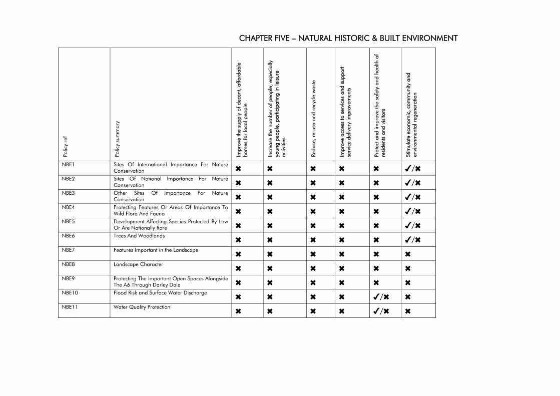
CHAPTER FIVE – NATURAL HISTORIC & BUILT ENVIRONMENT
Polic
y re
f
Polic
y su
mm
ary
Impr
ove
the
supp
ly o
f dec
ent,
affo
rdab
le
hom
es fo
r lo
cal p
eopl
e
Incr
ease
the
num
ber
of p
eopl
e, e
spec
ially
yo
ung
peop
le, p
artic
ipat
ing
in le
isur
e ac
tiviti
es
Redu
ce, r
e-us
e an
d re
cycl
e w
aste
Impr
ove
acce
ss to
ser
vice
s an
d su
ppor
t se
rvic
e de
liver
y im
prov
emen
ts
Prot
ect a
nd im
prov
e th
e sa
fety
and
hea
lth o
f re
side
nts
and
visi
tors
Stim
ulat
e ec
onom
ic, c
omm
unity
and
en
viro
nmen
tal r
egen
erat
ion
NBE1 Sites Of International Importance For Nature Conservation ✖ ✖ ✖ ✖ ✖ ✔/✖
NBE2 Sites Of National Importance For Nature Conservation ✖ ✖ ✖ ✖ ✖ ✔/✖
NBE3 Other Sites Of Importance For Nature Conservation ✖ ✖ ✖ ✖ ✖ ✔/✖
NBE4 Protecting Features Or Areas Of Importance To Wild Flora And Fauna ✖ ✖ ✖ ✖ ✖ ✔/✖
NBE5 Development Affecting Species Protected By Law Or Are Nationally Rare ✖ ✖ ✖ ✖ ✖ ✔/✖
NBE6 Trees And Woodlands ✖ ✖ ✖ ✖ ✖ ✔/✖ NBE7 Features Important in the Landscape ✖ ✖ ✖ ✖ ✖ ✖ NBE8 Landscape Character ✖ ✖ ✖ ✖ ✖ ✖ NBE9 Protecting The Important Open Spaces Alongside
The A6 Through Darley Dale ✖ ✖ ✖ ✖ ✖ ✖ NBE10 Flood Risk and Surface Water Discharge ✖ ✖ ✖ ✖ ✔/✖ ✖ NBE11 Water Quality Protection ✖ ✖ ✖ ✖ ✔/✖ ✖
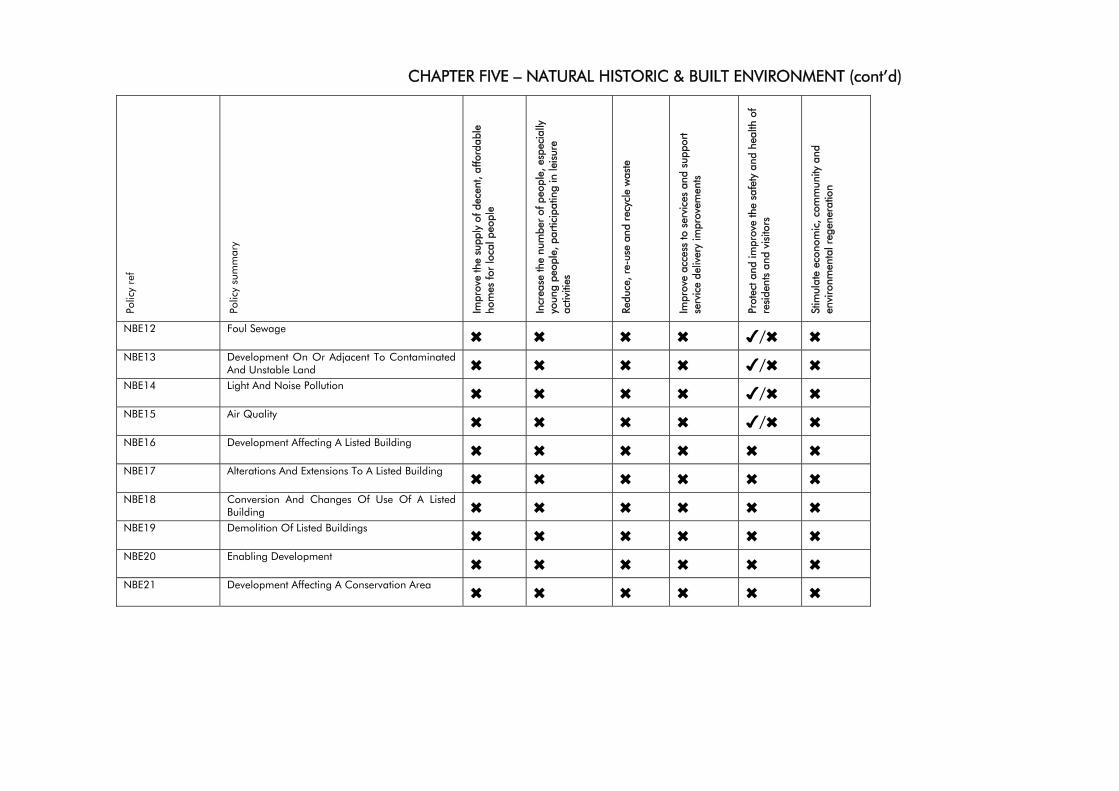
CHAPTER FIVE – NATURAL HISTORIC & BUILT ENVIRONMENT (cont’d)
Polic
y re
f
Polic
y su
mm
ary
Impr
ove
the
supp
ly o
f dec
ent,
affo
rdab
le
hom
es fo
r lo
cal p
eopl
e
Incr
ease
the
num
ber
of p
eopl
e, e
spec
ially
yo
ung
peop
le, p
artic
ipat
ing
in le
isur
e ac
tiviti
es
Redu
ce, r
e-us
e an
d re
cycl
e w
aste
Impr
ove
acce
ss to
ser
vice
s an
d su
ppor
t se
rvic
e de
liver
y im
prov
emen
ts
Prot
ect a
nd im
prov
e th
e sa
fety
and
hea
lth o
f re
side
nts
and
visi
tors
Stim
ulat
e ec
onom
ic, c
omm
unity
and
en
viro
nmen
tal r
egen
erat
ion
NBE12 Foul Sewage ✖ ✖ ✖ ✖ ✔/✖ ✖ NBE13 Development On Or Adjacent To Contaminated
And Unstable Land ✖ ✖ ✖ ✖ ✔/✖ ✖ NBE14 Light And Noise Pollution ✖ ✖ ✖ ✖ ✔/✖ ✖ NBE15 Air Quality ✖ ✖ ✖ ✖ ✔/✖ ✖ NBE16 Development Affecting A Listed Building ✖ ✖ ✖ ✖ ✖ ✖ NBE17 Alterations And Extensions To A Listed Building ✖ ✖ ✖ ✖ ✖ ✖ NBE18 Conversion And Changes Of Use Of A Listed
Building ✖ ✖ ✖ ✖ ✖ ✖ NBE19 Demolition Of Listed Buildings ✖ ✖ ✖ ✖ ✖ ✖ NBE20 Enabling Development ✖ ✖ ✖ ✖ ✖ ✖ NBE21 Development Affecting A Conservation Area ✖ ✖ ✖ ✖ ✖ ✖
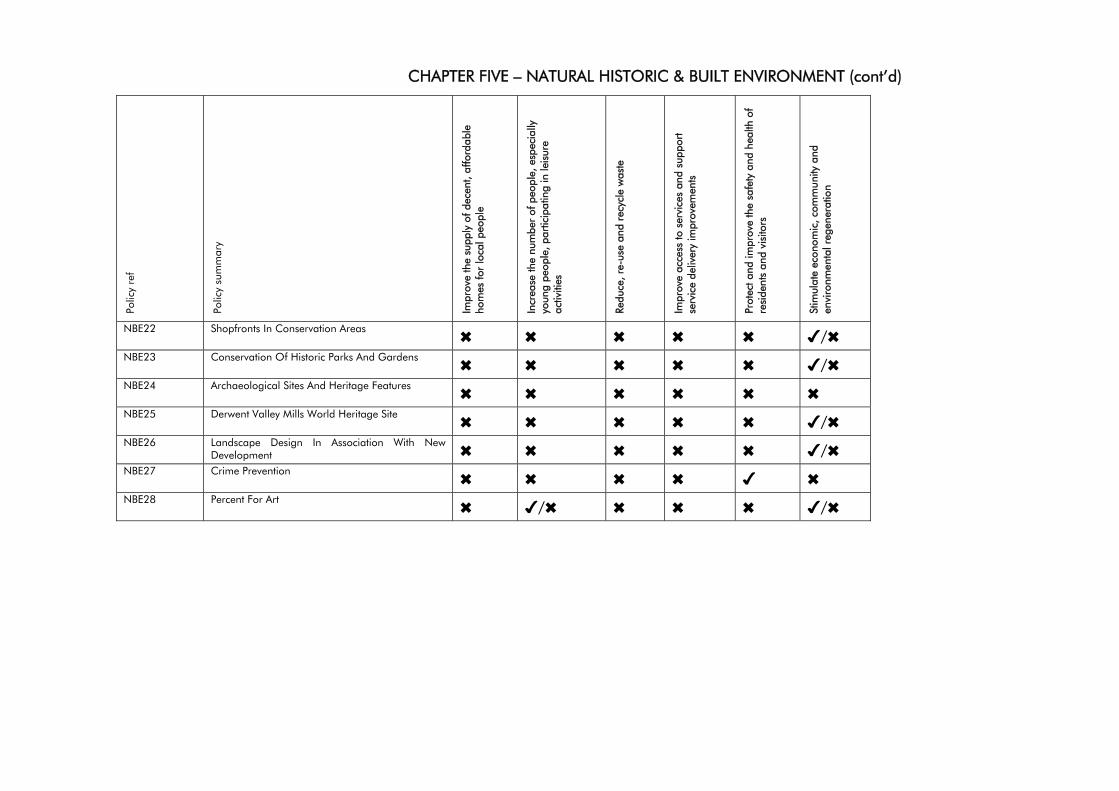
CHAPTER FIVE – NATURAL HISTORIC & BUILT ENVIRONMENT (cont’d)
Polic
y re
f
Polic
y su
mm
ary
Impr
ove
the
supp
ly o
f dec
ent,
affo
rdab
le
hom
es fo
r lo
cal p
eopl
e
Incr
ease
the
num
ber
of p
eopl
e, e
spec
ially
yo
ung
peop
le, p
artic
ipat
ing
in le
isur
e ac
tiviti
es
Redu
ce, r
e-us
e an
d re
cycl
e w
aste
Impr
ove
acce
ss to
ser
vice
s an
d su
ppor
t se
rvic
e de
liver
y im
prov
emen
ts
Prot
ect a
nd im
prov
e th
e sa
fety
and
hea
lth o
f re
side
nts
and
visi
tors
Stim
ulat
e ec
onom
ic, c
omm
unity
and
en
viro
nmen
tal r
egen
erat
ion
NBE22 Shopfronts In Conservation Areas ✖ ✖ ✖ ✖ ✖ ✔/✖ NBE23 Conservation Of Historic Parks And Gardens ✖ ✖ ✖ ✖ ✖ ✔/✖ NBE24 Archaeological Sites And Heritage Features ✖ ✖ ✖ ✖ ✖ ✖ NBE25 Derwent Valley Mills World Heritage Site ✖ ✖ ✖ ✖ ✖ ✔/✖ NBE26 Landscape Design In Association With New
Development ✖ ✖ ✖ ✖ ✖ ✔/✖ NBE27 Crime Prevention ✖ ✖ ✖ ✖ ✔ ✖ NBE28 Percent For Art ✖ ✔/✖ ✖ ✖ ✖ ✔/✖
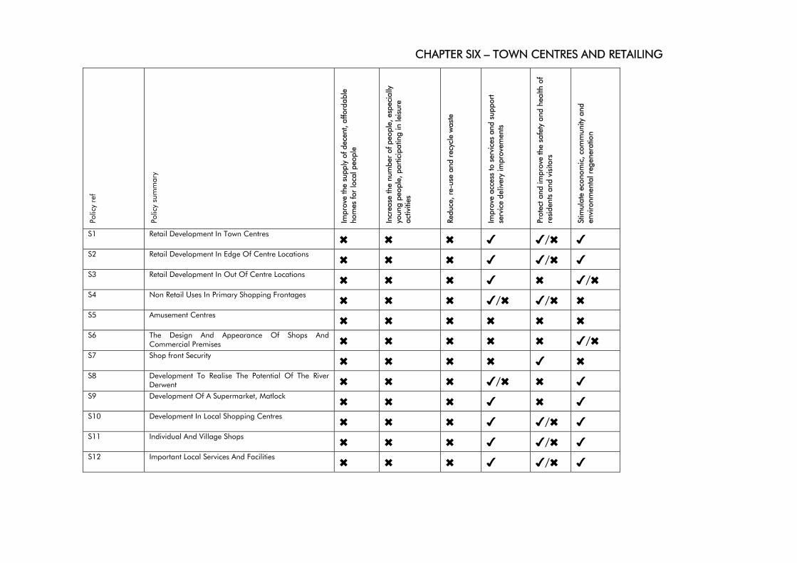
CHAPTER SIX – TOWN CENTRES AND RETAILING
Polic
y re
f
Polic
y su
mm
ary
Impr
ove
the
supp
ly o
f dec
ent,
affo
rdab
le
hom
es fo
r lo
cal p
eopl
e
Incr
ease
the
num
ber
of p
eopl
e, e
spec
ially
yo
ung
peop
le, p
artic
ipat
ing
in le
isur
e ac
tiviti
es
Redu
ce, r
e-us
e an
d re
cycl
e w
aste
Impr
ove
acce
ss to
ser
vice
s an
d su
ppor
t se
rvic
e de
liver
y im
prov
emen
ts
Prot
ect a
nd im
prov
e th
e sa
fety
and
hea
lth o
f re
side
nts
and
visi
tors
Stim
ulat
e ec
onom
ic, c
omm
unity
and
en
viro
nmen
tal r
egen
erat
ion
S1 Retail Development In Town Centres ✖ ✖ ✖ ✔ ✔/✖ ✔ S2 Retail Development In Edge Of Centre Locations ✖ ✖ ✖ ✔ ✔/✖ ✔ S3 Retail Development In Out Of Centre Locations ✖ ✖ ✖ ✔ ✖ ✔/✖ S4 Non Retail Uses In Primary Shopping Frontages ✖ ✖ ✖ ✔/✖ ✔/✖ ✖ S5 Amusement Centres ✖ ✖ ✖ ✖ ✖ ✖ S6 The Design And Appearance Of Shops And
Commercial Premises ✖ ✖ ✖ ✖ ✖ ✔/✖ S7 Shop front Security ✖ ✖ ✖ ✖ ✔ ✖ S8 Development To Realise The Potential Of The River
Derwent ✖ ✖ ✖ ✔/✖ ✖ ✔ S9 Development Of A Supermarket, Matlock ✖ ✖ ✖ ✔ ✖ ✔ S10 Development In Local Shopping Centres ✖ ✖ ✖ ✔ ✔/✖ ✔ S11 Individual And Village Shops ✖ ✖ ✖ ✔ ✔/✖ ✔ S12 Important Local Services And Facilities ✖ ✖ ✖ ✔ ✔/✖ ✔
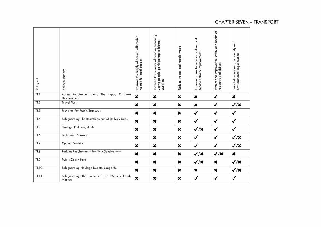
CHAPTER SEVEN – TRANSPORT
Polic
y re
f
Polic
y su
mm
ary
Impr
ove
the
supp
ly o
f dec
ent,
affo
rdab
le
hom
es fo
r lo
cal p
eopl
e
Incr
ease
the
num
ber
of p
eopl
e, e
spec
ially
yo
ung
peop
le, p
artic
ipat
ing
in le
isur
e ac
tiviti
es
Redu
ce, r
e-us
e an
d re
cycl
e w
aste
Impr
ove
acce
ss to
ser
vice
s an
d su
ppor
t se
rvic
e de
liver
y im
prov
emen
ts
Prot
ect a
nd im
prov
e th
e sa
fety
and
hea
lth o
f re
side
nts
and
visi
tors
Stim
ulat
e ec
onom
ic, c
omm
unity
and
en
viro
nmen
tal r
egen
erat
ion
TR1 Access Requirements And The Impact Of New Development ✖ ✖ ✖ ✖ ✔ ✖
TR2 Travel Plans ✖ ✖ ✖ ✖ ✔ ✔/✖ TR3 Provision For Public Transport ✖ ✖ ✖ ✔ ✔ ✔ TR4 Safeguarding The Reinstatement Of Railway Lines ✖ ✖ ✖ ✔ ✔ ✔ TR5 Strategic Rail Freight Site ✖ ✖ ✖ ✔/✖ ✔ ✔ TR6 Pedestrian Provision ✖ ✖ ✖ ✔ ✔ ✔/✖ TR7 Cycling Provision ✖ ✖ ✖ ✔ ✔ ✔/✖ TR8 Parking Requirements For New Development ✖ ✖ ✖ ✔/✖ ✔/✖ ✖ TR9 Public Coach Park ✖ ✖ ✖ ✔/✖ ✖ ✔/✖ TR10 Safeguarding Haulage Depots, Longcliffe ✖ ✖ ✖ ✖ ✖ ✔/✖ TR11 Safeguarding The Route Of The A6 Link Road,
Matlock ✖ ✖ ✖ ✔ ✔ ✔
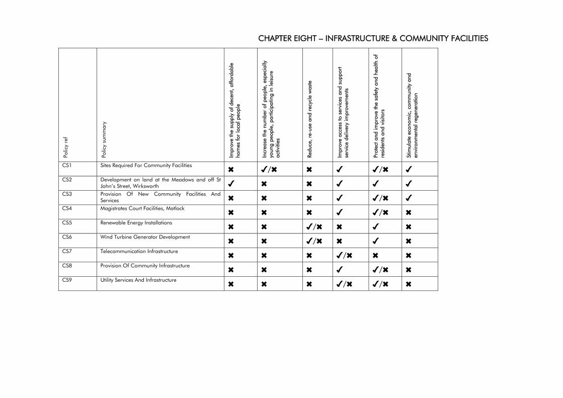
CHAPTER EIGHT – INFRASTRUCTURE & COMMUNITY FACILITIES
Polic
y re
f
Polic
y su
mm
ary
Impr
ove
the
supp
ly o
f dec
ent,
affo
rdab
le
hom
es fo
r lo
cal p
eopl
e
Incr
ease
the
num
ber
of p
eopl
e, e
spec
ially
yo
ung
peop
le, p
artic
ipat
ing
in le
isur
e ac
tiviti
es
Redu
ce, r
e-us
e an
d re
cycl
e w
aste
Impr
ove
acce
ss to
ser
vice
s an
d su
ppor
t se
rvic
e de
liver
y im
prov
emen
ts
Prot
ect a
nd im
prov
e th
e sa
fety
and
hea
lth o
f re
side
nts
and
visi
tors
Stim
ulat
e ec
onom
ic, c
omm
unity
and
en
viro
nmen
tal r
egen
erat
ion
CS1 Sites Required For Community Facilities ✖ ✔/✖ ✖ ✔ ✔/✖ ✔ CS2 Development on land at the Meadows and off St
John’s Street, Wirksworth ✔ ✖ ✖ ✔ ✔ ✔ CS3 Provision Of New Community Facilities And
Services ✖ ✖ ✖ ✔ ✔/✖ ✔ CS4 Magistrates Court Facilities, Matlock ✖ ✖ ✖ ✔ ✔/✖ ✖ CS5 Renewable Energy Installations ✖ ✖ ✔/✖ ✖ ✔ ✖ CS6 Wind Turbine Generator Development ✖ ✖ ✔/✖ ✖ ✔ ✖ CS7 Telecommunication Infrastructure ✖ ✖ ✖ ✔/✖ ✖ ✖ CS8 Provision Of Community Infrastructure ✖ ✖ ✖ ✔ ✔/✖ ✖ CS9 Utility Services And Infrastructure ✖ ✖ ✖ ✔/✖ ✔/✖ ✖
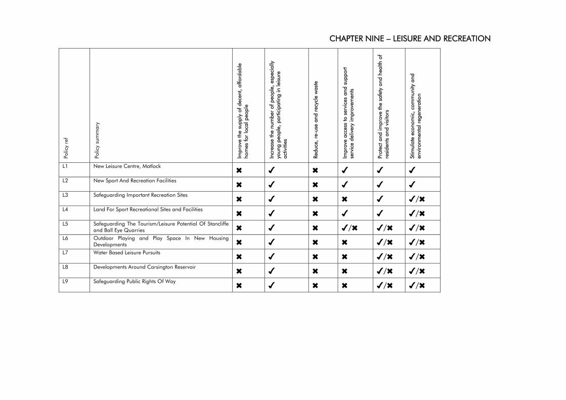
CHAPTER NINE – LEISURE AND RECREATION
Polic
y re
f
Polic
y su
mm
ary
Impr
ove
the
supp
ly o
f dec
ent,
affo
rdab
le
hom
es fo
r lo
cal p
eopl
e
Incr
ease
the
num
ber
of p
eopl
e, e
spec
ially
yo
ung
peop
le, p
artic
ipat
ing
in le
isur
e ac
tiviti
es
Redu
ce, r
e-us
e an
d re
cycl
e w
aste
Impr
ove
acce
ss to
ser
vice
s an
d su
ppor
t se
rvic
e de
liver
y im
prov
emen
ts
Prot
ect a
nd im
prov
e th
e sa
fety
and
hea
lth o
f re
side
nts
and
visi
tors
Stim
ulat
e ec
onom
ic, c
omm
unity
and
en
viro
nmen
tal r
egen
erat
ion
L1 New Leisure Centre, Matlock ✖ ✔ ✖ ✔ ✔ ✔ L2 New Sport And Recreation Facilities ✖ ✔ ✖ ✔ ✔ ✔ L3 Safeguarding Important Recreation Sites ✖ ✔ ✖ ✖ ✔ ✔/✖ L4 Land For Sport Recreational Sites and Facilities ✖ ✔ ✖ ✔ ✔ ✔/✖ L5 Safeguarding The Tourism/Leisure Potential Of Stancliffe
and Ball Eye Quarries ✖ ✔ ✖ ✔/✖ ✔/✖ ✔/✖ L6 Outdoor Playing and Play Space In New Housing
Developments ✖ ✔ ✖ ✖ ✔/✖ ✔/✖ L7 Water Based Leisure Pursuits ✖ ✔ ✖ ✖ ✔/✖ ✔/✖ L8 Developments Around Carsington Reservoir ✖ ✔ ✖ ✖ ✔/✖ ✔/✖ L9 Safeguarding Public Rights Of Way ✖ ✔ ✖ ✖ ✔/✖ ✔/✖
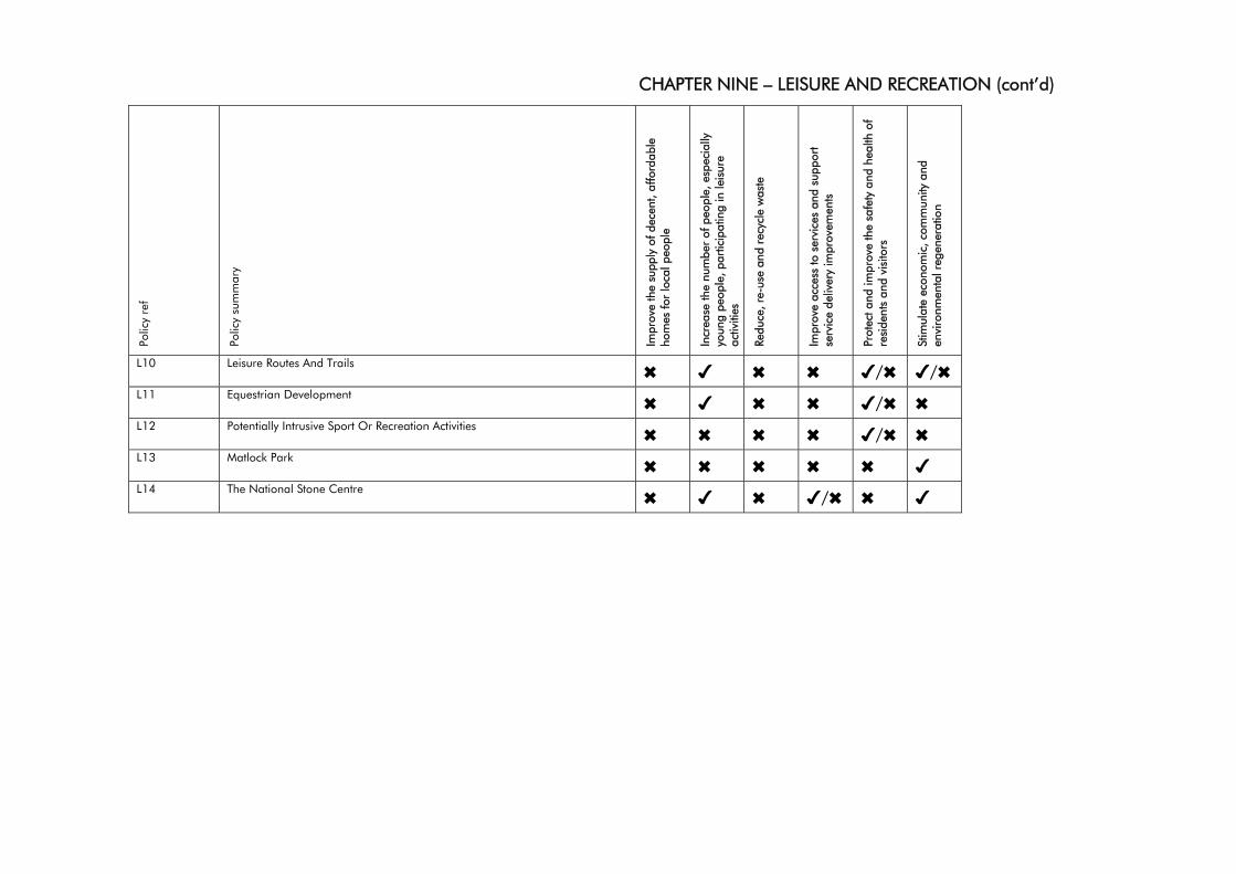
CHAPTER NINE – LEISURE AND RECREATION (cont’d)
Polic
y re
f
Polic
y su
mm
ary
Impr
ove
the
supp
ly o
f dec
ent,
affo
rdab
le
hom
es fo
r lo
cal p
eopl
e
Incr
ease
the
num
ber
of p
eopl
e, e
spec
ially
yo
ung
peop
le, p
artic
ipat
ing
in le
isur
e ac
tiviti
es
Redu
ce, r
e-us
e an
d re
cycl
e w
aste
Impr
ove
acce
ss to
ser
vice
s an
d su
ppor
t se
rvic
e de
liver
y im
prov
emen
ts
Prot
ect a
nd im
prov
e th
e sa
fety
and
hea
lth o
f re
side
nts
and
visi
tors
Stim
ulat
e ec
onom
ic, c
omm
unity
and
en
viro
nmen
tal r
egen
erat
ion
L10 Leisure Routes And Trails ✖ ✔ ✖ ✖ ✔/✖ ✔/✖ L11 Equestrian Development ✖ ✔ ✖ ✖ ✔/✖ ✖ L12 Potentially Intrusive Sport Or Recreation Activities ✖ ✖ ✖ ✖ ✔/✖ ✖ L13 Matlock Park ✖ ✖ ✖ ✖ ✖ ✔ L14 The National Stone Centre ✖ ✔ ✖ ✔/✖ ✖ ✔
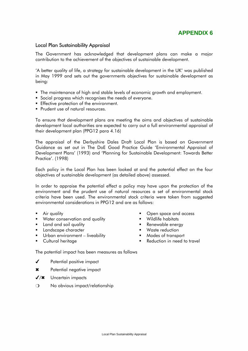
APPENDIX 6
Local Plan Sustainability Appraisal
The Government has acknowledged that development plans can make a major contribution to the achievement of the objectives of sustainable development. ‘A better quality of life, a strategy for sustainable development in the UK’ was published in May 1999 and sets out the governments objectives for sustainable development as being:
The maintenance of high and stable levels of economic growth and employment. Social progress which recognises the needs of everyone. Effective protection of the environment. Prudent use of natural resources.
To ensure that development plans are meeting the aims and objectives of sustainable development local authorities are expected to carry out a full environmental appraisal of their development plan (PPG12 para 4.16) The appraisal of the Derbyshire Dales Draft Local Plan is based on Government Guidance as set out in The DoE Good Practice Guide ‘Environmental Appraisal of Development Plans’ (1993) and ‘Planning for Sustainable Development: Towards Better Practice’. (1998) Each policy in the Local Plan has been looked at and the potential effect on the four objectives of sustainable development (as detailed above) assessed. In order to appraise the potential effect a policy may have upon the protection of the environment and the prudent use of natural resources a set of environmental stock criteria have been used. The environmental stock criteria were taken from suggested environmental considerations in PPG12 and are as follows: Air quality Water conservation and quality Land and soil quality Landscape character Urban environment – liveability Cultural heritage
Open space and access Wildlife habitats Renewable energy Waste reduction Modes of transport Reduction in need to travel
The potential impact has been measures as follows
✔ Potential positive impact
✖ Potential negative impact
✔/✖ Uncertain impacts
❍ No obvious impact/relationship
Local Plan Sustainability Appraisal
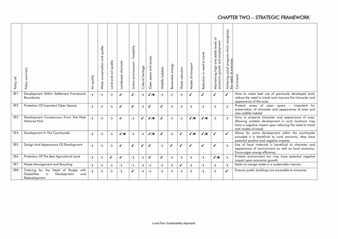
Local Plan Sustainability Appraisal
CHAPTER TWO – STRATEGIC FRAMEWORK Po
licy
ref
Polic
y su
mm
ary
Air
qual
ity
Wat
er c
onse
rvat
ion
and
qual
ity
Land
and
soi
l qua
lity
Land
scap
e ch
arac
ter
Urb
an e
nviro
nmen
t – li
veab
ility
Cul
tura
l her
itage
Ope
n sp
ace
and
acce
ss
Wild
life
habi
tats
Re
new
able
ene
rgy
Was
te r
educ
tion
Mod
es o
f tra
nspo
rt
Redu
ctio
n in
nee
d to
trav
el
Mai
ntai
ning
hig
h an
d st
able
leve
ls o
f ec
onom
ic g
row
th a
nd e
mpl
oym
ent
Ach
ievi
ng s
ocia
l pro
gres
s w
hich
rec
ogni
ses
the
need
s of
eve
r yon
e
Com
men
ts
SF1 Development Within Settlement Framework Boundaries
❍ ❍ ❍ ✔ ✔ ❍ ✔/✖ ❍ ❍ ❍ ✔ ✔ ✔ ✔ Aims to make best use of previously developed land, reduce the need to travel and improve the character and appearance of the area.
SF2 Protection Of Important Open Spaces ❍ ❍ ❍ ✔ ✔ ❍ ✔ ✔ ❍ ❍ ❍ ❍ ❍ ❍ Protects areas of open space – important for preservation of character and appearance of area and also wildlife habitat.
SF3 Development Conspicuous From The Peak National Park
❍ ❍ ❍ ✔ ❍ ✔ ✔/✖ ✔ ❍ ❍ ✔/✖ ✔/✖ ❍ ❍ Aims to preserve character and appearance of area. Allowing suitable development in such locations may have a negative impact upon reducing the need to travel and modes of travel.
SF4 Development In The Countryside ❍ ❍ ❍ ✔/✖ ❍ ❍ ✔/✖ ✔ ❍ ✔ ✔/✖ ✔/✖ ✔ ✔ Allows for some development within the countryside provided it is beneficial to rural economy. May have potential positive and negative impacts.
SF5 Design And Appearance Of Development ❍ ❍ ❍ ✔ ✔ ✔ ✔ ❍ ✔ ✔ ✔ ✔ ✔ ❍ Use of local materials is beneficial to character and appearance of environment as well as local economy. Encourages energy efficiency.
SF6 Protection Of The Best Agricultural Land ❍ ❍ ✔ ✔ ❍ ❍ ✔ ✔ ❍ ❍ ❍ ❍ ✔/✖ ❍ Protects environment but may have potential negative impact upon economic growth.
SF7 Waste Management and Recycling ❍ ❍ ❍ ❍ ❍ ❍ ❍ ❍ ❍ ✔ ❍ ❍ ❍ ❍ Seeks to mange waste in a sustainable manner.
SF8 Catering for the Need of People with Disabilities in Development and Redevelopment
❍ ❍ ❍ ❍ ✔ ❍ ❍ ❍ ❍ ❍ ❍ ❍ ❍ ✔ Ensures public buildings are accessible to everyone.
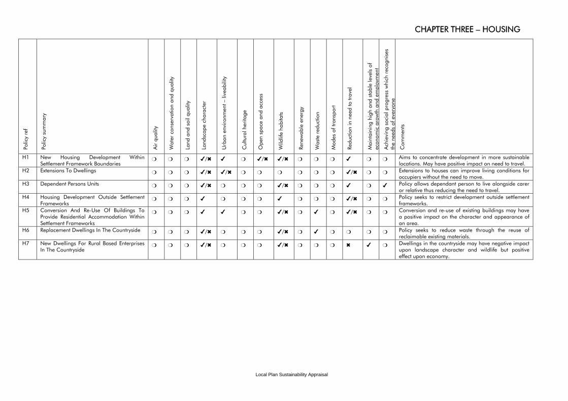
Local Plan Sustainability Appraisal
CHAPTER THREE – HOUSING Po
licy
ref
Polic
y su
mm
ary
Air
qual
ity
Wat
er c
onse
rvat
ion
and
qual
ity
Land
and
soi
l qua
lity
Land
scap
e ch
arac
ter
Urb
an e
nviro
nmen
t – li
veab
ility
Cul
tura
l her
itage
Ope
n sp
ace
and
acce
ss
Wild
life
habi
tats
Re
new
able
ene
rgy
Was
te r
educ
tion
Mod
es o
f tra
nspo
rt
Redu
ctio
n in
nee
d to
trav
el
Mai
ntai
ning
hig
h an
d st
able
leve
ls o
f ec
onom
ic g
row
th a
nd e
mpl
oym
ent
Ach
ievi
ng s
ocia
l pro
gres
s w
hich
rec
ogni
ses
the
need
s of
eve
r yon
e
Com
men
ts
H1 New Housing Development Within Settlement Framework Boundaries
❍ ❍ ❍ ✔/✖ ✔ ❍ ✔/✖ ✔/✖ ❍ ❍ ❍ ✔ ❍ ❍ Aims to concentrate development in more sustainable locations. May have positive impact on need to travel.
H2 Extensions To Dwellings ❍ ❍ ❍ ✔/✖ ✔/✖ ❍ ❍ ❍ ❍ ❍ ❍ ✔/✖ ❍ ❍ Extensions to houses can improve living conditions for occupiers without the need to move.
H3 Dependent Persons Units ❍ ❍ ❍ ✔/✖ ❍ ❍ ❍ ✔/✖ ❍ ❍ ❍ ✔ ❍ ✔ Policy allows dependant person to live alongside carer or relative thus reducing the need to travel.
H4 Housing Development Outside Settlement Frameworks
❍ ❍ ❍ ✔ ❍ ❍ ❍ ✔ ❍ ❍ ❍ ✔/✖ ❍ ❍ Policy seeks to restrict development outside settlement frameworks.
H5 Conversion And Re-Use Of Buildings To Provide Residential Accommodation Within Settlement Frameworks
❍ ❍ ❍ ✔ ✔ ❍ ❍ ✔/✖ ❍ ✔ ❍ ✔/✖ ❍ ❍ Conversion and re-use of existing buildings may have a positive impact on the character and appearance of an area.
H6 Replacement Dwellings In The Countryside ❍ ❍ ❍ ✔/✖ ❍ ❍ ❍ ✔/✖ ❍ ✔ ❍ ❍ ❍ ❍ Policy seeks to reduce waste through the reuse of reclaimable existing materials.
H7 New Dwellings For Rural Based Enterprises In The Countryside
❍ ❍ ❍ ✔/✖ ❍ ❍ ❍ ✔/✖ ❍ ❍ ❍ ✖ ✔ ❍ Dwellings in the countryside may have negative impact upon landscape character and wildlife but positive effect upon economy.

Local Plan Sustainability Appraisal
CHAPTER THREE – HOUSING (cont’d) Po
licy
ref
Polic
y su
mm
ary
Air
qual
ity
Wat
er c
onse
rvat
ion
and
qual
ity
Land
and
soi
l qua
lity
Land
scap
e ch
arac
ter
Urb
an e
nviro
nmen
t – li
veab
ility
Cul
tura
l her
itage
Ope
n sp
ace
and
acce
ss
Wild
life
habi
tats
Re
new
able
ene
rgy
Was
te r
educ
tion
Mod
es o
f tra
nspo
rt
Redu
ctio
n in
nee
d to
trav
el
Mai
ntai
ning
hig
h an
d st
able
leve
ls o
f ec
onom
ic g
row
th a
nd e
mpl
oym
ent
Ach
ievi
ng s
ocia
l pro
gres
s w
hich
rec
ogni
ses
the
need
s of
eve
r yon
e
Com
men
ts
H7 New Dwellings For Agricultural or Forestry Workers Rural Based Enterprises In The Countryside
❍ ❍ ❍ ✔/✖ ❍ ❍ ❍ ✔/✖ ❍ ❍ ❍ ✖ ✔ ❍ Due to countryside location policy may have negative impact on need tot ravel.
H8 Extending Domestic Curtilages Into The Countryside
❍ ❍ ❍ ✔/✖ ❍ ❍ ❍ ✔/✖ ❍ ❍ ❍ ❍ ❍ ❍ Policy seeks to limit impact upon character of the landscape.
H9 Design And Appearance Of New Housing ❍ ❍ ❍ ✔ ✔ ❍ ✔ ❍ ❍ ❍ ✔ ✔/✖ ❍ ❍ Policy seeks to raise densities in areas with good access to public transport.
H10 Affordable Housing Within The Settlement Frameworks Of Market Towns
❍ ❍ ❍ ✔/✖ ✔ ❍ ❍ ✔/✖ ❍ ❍ ✔ ✔ ❍ ✔ Policy seeks to provide housing for everyone.
H11 Affordable Housing Within The Settlement Frameworks Of Other Settlements
❍ ❍ ❍ ✔/✖ ✔ ❍ ❍ ✔/✖ ❍ ❍ ❍ ✔/✖ ❍ ✔ Outside the Market Towns the policy may have an adverse impact upon the need to travel.
H12 Alternative Provision For Affordable Housing Outside Settlement Frameworks
❍ ❍ ❍ ✔ ❍ ❍ ❍ ❍ ❍ ❍ ❍ ❍ ❍ ✔ Policy may have positive impact on landscape character by siting affordable housing in most suitable locations.
H13 Affordable Housing Exceptional Sites in Rural Areas
❍ ❍ ❍ ✔/✖ ❍ ❍ ✔/✖ ✔/✖ ❍ ❍ ❍ ✔/✖ ❍ ✔ Policy may have impact on need to travel as rural areas tend to lack services and facilities.
H14 Housing To Meet The Needs Of The Elderly And People With Disabilities
❍ ❍ ❍ ❍ ❍ ❍ ❍ ❍ ❍ ❍ ✔ ✔ ❍ ✔ Policy seeks to reduce need to travel by siting housing close to shops and services.
H15 Accommodation For Gypsies ❍ ✔ ✔ ✔/✖ ✔ ❍ ❍ ✔/✖ ❍ ❍ ❍ ✔ ❍ ✔ Policy seeks to limit impact upon environment and landscape.
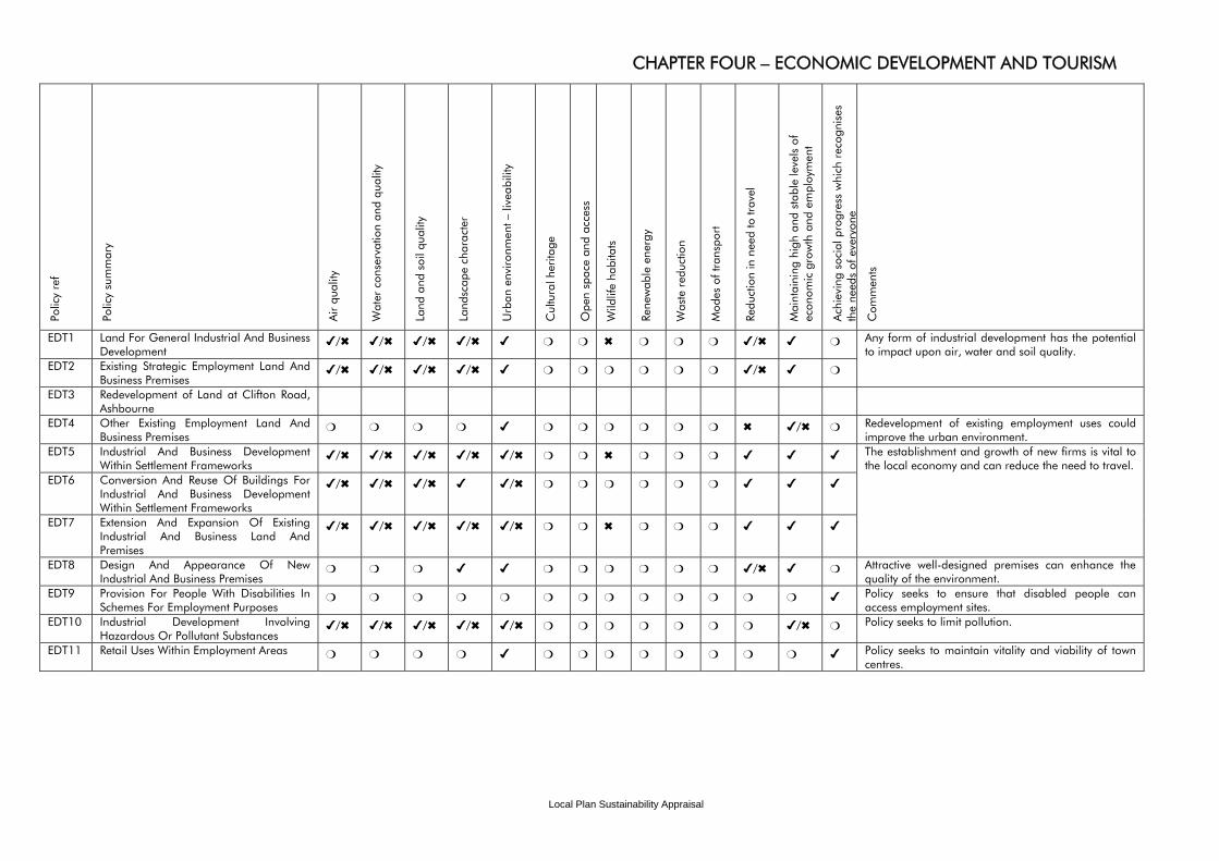
Local Plan Sustainability Appraisal
CHAPTER FOUR – ECONOMIC DEVELOPMENT AND TOURISM Po
licy
ref
Polic
y su
mm
ary
Air
qual
ity
Wat
er c
onse
rvat
ion
and
qual
ity
Land
and
soi
l qua
lity
Land
scap
e ch
arac
ter
Urb
an e
nviro
nmen
t – li
veab
ility
Cul
tura
l her
itage
Ope
n sp
ace
and
acce
ss
Wild
life
habi
tats
Re
new
able
ene
rgy
Was
te r
educ
tion
Mod
es o
f tra
nspo
rt
Redu
ctio
n in
nee
d to
trav
el
Mai
ntai
ning
hig
h an
d st
able
leve
ls o
f ec
onom
ic g
row
th a
nd e
mpl
oym
ent
Ach
ievi
ng s
ocia
l pro
gres
s w
hich
rec
ogni
ses
the
need
s of
eve
r yon
e
Com
men
ts
EDT1 Land For General Industrial And Business Development
✔/✖ ✔/✖ ✔/✖ ✔/✖ ✔ ❍ ❍ ✖ ❍ ❍ ❍ ✔/✖ ✔ ❍
EDT2 Existing Strategic Employment Land And Business Premises
✔/✖ ✔/✖ ✔/✖ ✔/✖ ✔ ❍ ❍ ❍ ❍ ❍ ❍ ✔/✖ ✔ ❍
Any form of industrial development has the potential to impact upon air, water and soil quality.
EDT3 Redevelopment of Land at Clifton Road, Ashbourne
EDT4 Other Existing Employment Land And Business Premises
❍ ❍ ❍ ❍ ✔ ❍ ❍ ❍ ❍ ❍ ❍ ✖ ✔/✖ ❍ Redevelopment of existing employment uses could improve the urban environment.
EDT5 Industrial And Business Development Within Settlement Frameworks
✔/✖ ✔/✖ ✔/✖ ✔/✖ ✔/✖ ❍ ❍ ✖ ❍ ❍ ❍ ✔ ✔ ✔
EDT6 Conversion And Reuse Of Buildings For Industrial And Business Development Within Settlement Frameworks
✔/✖ ✔/✖ ✔/✖ ✔ ✔/✖ ❍ ❍ ❍ ❍ ❍ ❍ ✔ ✔ ✔
EDT7 Extension And Expansion Of Existing Industrial And Business Land And Premises
✔/✖ ✔/✖ ✔/✖ ✔/✖ ✔/✖ ❍ ❍ ✖ ❍ ❍ ❍ ✔ ✔ ✔
The establishment and growth of new firms is vital to the local economy and can reduce the need to travel.
EDT8 Design And Appearance Of New Industrial And Business Premises
❍ ❍ ❍ ✔ ✔ ❍ ❍ ❍ ❍ ❍ ❍ ✔/✖ ✔ ❍ Attractive well-designed premises can enhance the quality of the environment.
EDT9 Provision For People With Disabilities In Schemes For Employment Purposes
❍ ❍ ❍ ❍ ❍ ❍ ❍ ❍ ❍ ❍ ❍ ❍ ❍ ✔ Policy seeks to ensure that disabled people can access employment sites.
EDT10 Industrial Development Involving Hazardous Or Pollutant Substances
✔/✖ ✔/✖ ✔/✖ ✔/✖ ✔/✖ ❍ ❍ ❍ ❍ ❍ ❍ ❍ ✔/✖ ❍ Policy seeks to limit pollution.
EDT11 Retail Uses Within Employment Areas ❍ ❍ ❍ ❍ ✔ ❍ ❍ ❍ ❍ ❍ ❍ ❍ ❍ ✔ Policy seeks to maintain vitality and viability of town centres.
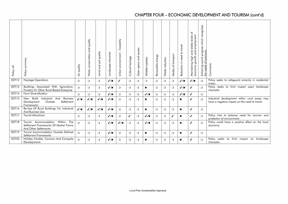
Local Plan Sustainability Appraisal
CHAPTER FOUR – ECONOMIC DEVELOPMENT AND TOURISM (cont’d) Po
licy
ref
Polic
y su
mm
ary
Air
qual
ity
Wat
er c
onse
rvat
ion
and
qual
ity
Land
and
soi
l qua
lity
Land
scap
e ch
arac
ter
Urb
an e
nviro
nmen
t – li
veab
ility
Cul
tura
l her
itage
Ope
n sp
ace
and
acce
ss
Wild
life
habi
tats
Re
new
able
ene
rgy
Was
te r
educ
tion
Mod
es o
f tra
nspo
rt
Redu
ctio
n in
nee
d to
trav
el
Mai
ntai
ning
hig
h an
d st
able
leve
ls o
f ec
onom
ic g
row
th a
nd e
mpl
oym
ent
Ach
ievi
ng s
ocia
l pro
gres
s w
hich
rec
ogni
ses
the
need
s of
eve
r yon
e
Com
men
ts
EDT12 Haulage Operations ❍ ❍ ❍ ✔/✖ ✔ ❍ ❍ ❍ ❍ ❍ ❍ ✔/✖ ✔/✖ ❍ Policy seeks to safeguard amenity in residential areas.
EDT13 Buildings Associated With Agriculture, Forestry Or Other Rural Based Enterprise
❍ ❍ ❍ ✔/✖ ❍ ❍ ❍ ✖ ❍ ❍ ❍ ✔/✖ ✔ ❍
EDT14 Farm Diversification ❍ ❍ ❍ ✔/✖ ❍ ❍ ❍ ✔/✖ ❍ ❍ ❍ ✔/✖ ✔ ❍
Policy seeks to limit impact upon landscape character.
EDT15 New Build Industrial And Business Development Outside Settlement Frameworks
✔/✖ ✔/✖ ✔/✖ ✔/✖ ❍ ❍ ❍ ✖ ❍ ❍ ❍ ✖ ✔ ❍
EDT16 Re-Use Of Rural Buildings For Industrial And Business Use
✔/✖ ✔/✖ ✔/✖ ✔/✖ ❍ ❍ ❍ ✖ ❍ ❍ ❍ ✖ ✔ ❍
Industrial development within rural areas may have a negative impact on the need to travel.
EDT17 Tourist Attractions ❍ ❍ ❍ ✔/✖ ❍ ✔ ❍ ✔/✖ ❍ ❍ ✔ ✖ ✔ ❍ Policy tries to balance need for tourism and protection of environment.
EDT18 Tourist Accommodation Within The Settlement Frameworks Of Market Towns And Other Settlements
❍ ❍ ❍ ✔/✖ ✔/✖ ❍ ❍ ✔/✖ ❍ ❍ ❍ ✖ ✔ ❍ Policy could have a positive effect on the local economy.
EDT19 Tourist Accommodation Outside Defined Settlement Frameworks
❍ ❍ ❍ ✔/✖ ❍ ❍ ❍ ✖ ❍ ❍ ❍ ✖ ✔ ❍
EDT20 Holiday Chalets, Caravan And Campsite Developments
❍ ❍ ❍ ✔/✖ ❍ ❍ ❍ ✖ ❍ ❍ ❍ ✖ ✔ ❍ Policy seeks to limit impact on landscape character.
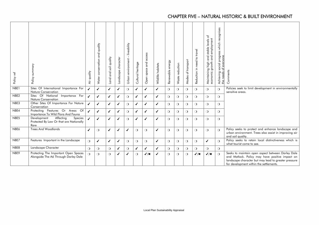
Local Plan Sustainability Appraisal
CHAPTER FIVE – NATURAL HISTORIC & BUILT ENVIRONMENT Po
licy
ref
Polic
y su
mm
ary
Air
qual
ity
Wat
er c
onse
rvat
ion
and
qual
ity
Land
and
soi
l qua
lity
Land
scap
e ch
arac
ter
Urb
an e
nviro
nmen
t – li
veab
ility
Cul
tura
l her
itage
Ope
n sp
ace
and
acce
ss
Wild
life
habi
tats
Re
new
able
ene
rgy
Was
te r
educ
tion
Mod
es o
f tra
nspo
rt
Redu
ctio
n in
nee
d to
trav
el
Mai
ntai
ning
hig
h an
d st
able
leve
ls o
f ec
onom
ic g
row
th a
nd e
mpl
oym
ent
Ach
ievi
ng s
ocia
l pro
gres
s w
hich
rec
ogni
ses
the
need
s of
eve
r yon
e
Com
men
ts
NBE1 Sites Of International Importance For Nature Conservation
✔ ✔ ✔ ✔ ❍ ✔ ✔ ✔ ❍ ❍ ❍ ❍ ❍ ❍
NBE2 Sites Of National Importance For Nature Conservation
✔ ✔ ✔ ✔ ❍ ✔ ✔ ✔ ❍ ❍ ❍ ❍ ❍ ❍
NBE3 Other Sites Of Importance For Nature Conservation
✔ ✔ ✔ ✔ ❍ ✔ ✔ ✔ ❍ ❍ ❍ ❍ ❍ ❍
NBE4 Protecting Features Or Areas Of Importance To Wild Flora And Fauna
✔ ✔ ✔ ✔ ❍ ✔ ✔ ✔ ❍ ❍ ❍ ❍ ❍ ❍
NBE5 Development Affecting Species Protected By Law Or that are Nationally Rare
✔ ✔ ✔ ✔ ❍ ✔ ✔ ✔ ❍ ❍ ❍ ❍ ❍ ❍
Policies seek to limit development in environmentally sensitive areas.
NBE6 Trees And Woodlands ✔ ❍ ✔ ✔ ✔ ❍ ❍ ✔ ❍ ❍ ❍ ❍ ❍ ❍ Policy seeks to protect and enhance landscape and urban environment. Trees also assist in improving air and soil quality.
NBE7 Features Important in the Landscape ❍ ✔ ✔ ✔ ❍ ❍ ❍ ✔ ❍ ❍ ❍ ❍ ✔ ❍ Policy seeks to retain local distinctiveness which is what tourist come to see.
NBE8 Landscape Character ❍ ❍ ❍ ✔ ❍ ✔ ✔ ✔ ❍ ❍ ❍ ❍ ❍ ❍
NBE9 Protecting The Important Open Spaces Alongside The A6 Through Darley Dale
❍ ❍ ❍ ✔ ✔ ❍ ✔/✖ ✔ ❍ ❍ ❍ ✔/✖ ✔/✖ ❍ Seeks to maintain open aspect between Darley Dale and Matlock. Policy may have positive impact on landscape character but may lead to greater pressure for development within the settlements.
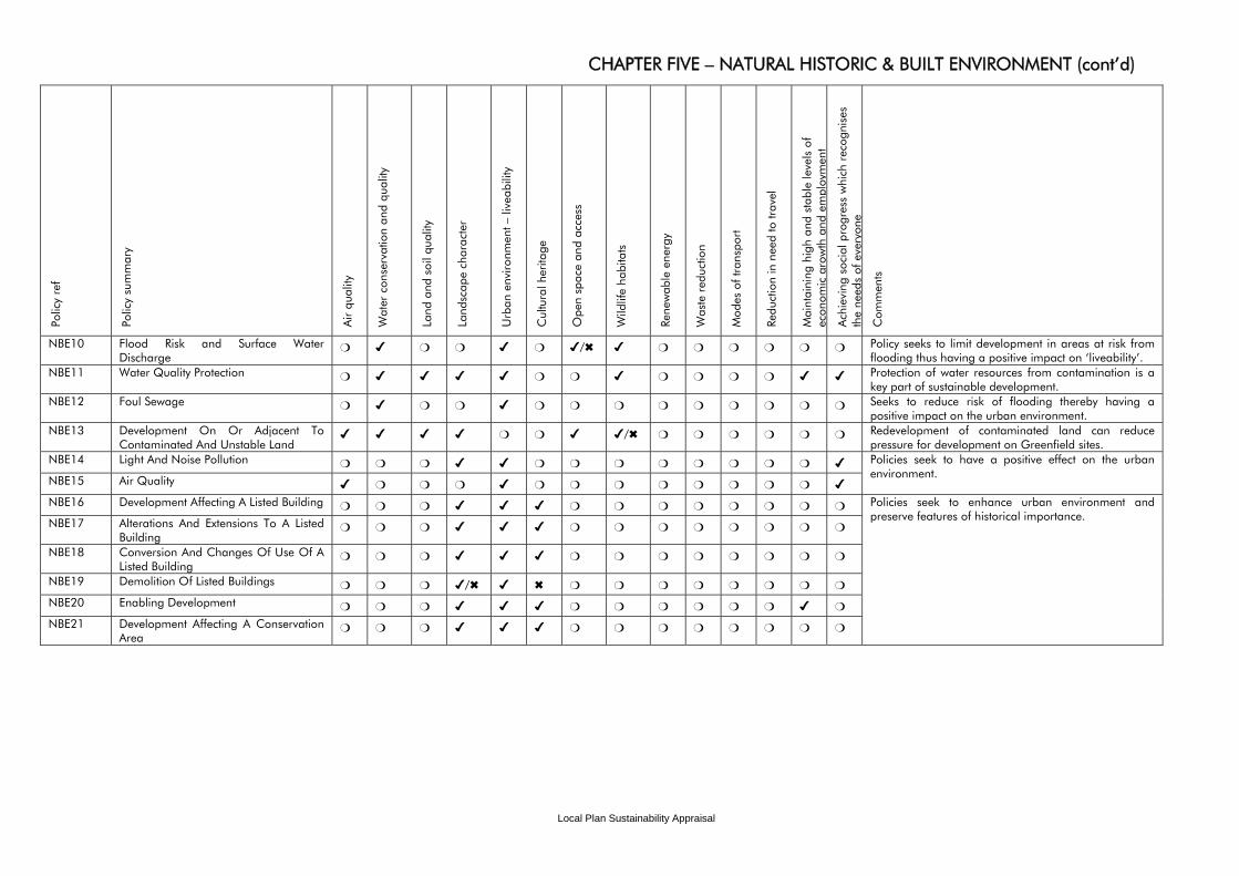
Local Plan Sustainability Appraisal
CHAPTER FIVE – NATURAL HISTORIC & BUILT ENVIRONMENT (cont’d) Po
licy
ref
Polic
y su
mm
ary
Air
qual
ity
Wat
er c
onse
rvat
ion
and
qual
ity
Land
and
soi
l qua
lity
Land
scap
e ch
arac
ter
Urb
an e
nviro
nmen
t – li
veab
ility
Cul
tura
l her
itage
Ope
n sp
ace
and
acce
ss
Wild
life
habi
tats
Re
new
able
ene
rgy
Was
te r
educ
tion
Mod
es o
f tra
nspo
rt
Redu
ctio
n in
nee
d to
trav
el
Mai
ntai
ning
hig
h an
d st
able
leve
ls o
f ec
onom
ic g
row
th a
nd e
mpl
oym
ent
Ach
ievi
ng s
ocia
l pro
gres
s w
hich
rec
ogni
ses
the
need
s of
eve
r yon
e
Com
men
ts
NBE10 Flood Risk and Surface Water Discharge
❍ ✔ ❍ ❍ ✔ ❍ ✔/✖ ✔ ❍ ❍ ❍ ❍ ❍ ❍ Policy seeks to limit development in areas at risk from flooding thus having a positive impact on ‘liveability’.
NBE11 Water Quality Protection ❍ ✔ ✔ ✔ ✔ ❍ ❍ ✔ ❍ ❍ ❍ ❍ ✔ ✔ Protection of water resources from contamination is a key part of sustainable development.
NBE12 Foul Sewage ❍ ✔ ❍ ❍ ✔ ❍ ❍ ❍ ❍ ❍ ❍ ❍ ❍ ❍ Seeks to reduce risk of flooding thereby having a positive impact on the urban environment.
NBE13 Development On Or Adjacent To Contaminated And Unstable Land
✔ ✔ ✔ ✔ ❍ ❍ ✔ ✔/✖ ❍ ❍ ❍ ❍ ❍ ❍ Redevelopment of contaminated land can reduce pressure for development on Greenfield sites.
NBE14 Light And Noise Pollution ❍ ❍ ❍ ✔ ✔ ❍ ❍ ❍ ❍ ❍ ❍ ❍ ❍ ✔
NBE15 Air Quality ✔ ❍ ❍ ❍ ✔ ❍ ❍ ❍ ❍ ❍ ❍ ❍ ❍ ✔
Policies seek to have a positive effect on the urban environment.
NBE16 Development Affecting A Listed Building ❍ ❍ ❍ ✔ ✔ ✔ ❍ ❍ ❍ ❍ ❍ ❍ ❍ ❍ NBE17 Alterations And Extensions To A Listed
Building ❍ ❍ ❍ ✔ ✔ ✔ ❍ ❍ ❍ ❍ ❍ ❍ ❍ ❍
NBE18 Conversion And Changes Of Use Of A Listed Building
❍ ❍ ❍ ✔ ✔ ✔ ❍ ❍ ❍ ❍ ❍ ❍ ❍ ❍
NBE19 Demolition Of Listed Buildings ❍ ❍ ❍ ✔/✖ ✔ ✖ ❍ ❍ ❍ ❍ ❍ ❍ ❍ ❍
NBE20 Enabling Development ❍ ❍ ❍ ✔ ✔ ✔ ❍ ❍ ❍ ❍ ❍ ❍ ✔ ❍
NBE21 Development Affecting A Conservation Area
❍ ❍ ❍ ✔ ✔ ✔ ❍ ❍ ❍ ❍ ❍ ❍ ❍ ❍
Policies seek to enhance urban environment and preserve features of historical importance.
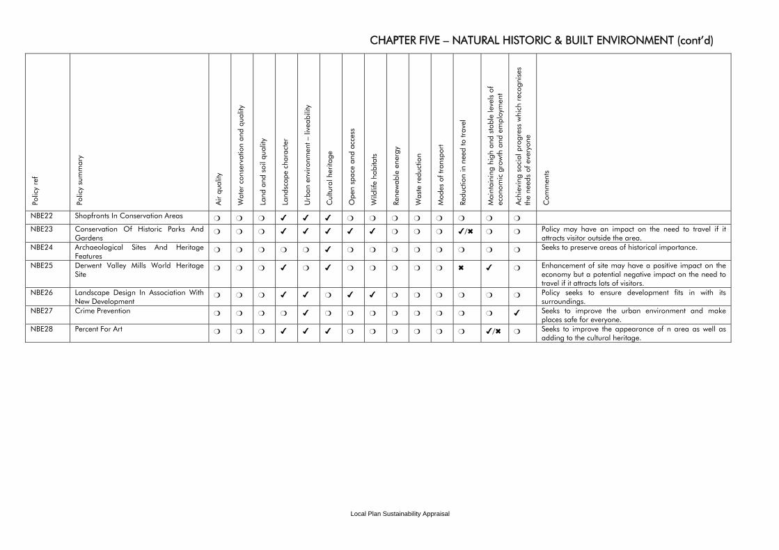
Local Plan Sustainability Appraisal
CHAPTER FIVE – NATURAL HISTORIC & BUILT ENVIRONMENT (cont’d) Po
licy
ref
Polic
y su
mm
ary
Air
qual
ity
Wat
er c
onse
rvat
ion
and
qual
ity
Land
and
soi
l qua
lity
Land
scap
e ch
arac
ter
Urb
an e
nviro
nmen
t – li
veab
ility
Cul
tura
l her
itage
Ope
n sp
ace
and
acce
ss
Wild
life
habi
tats
Re
new
able
ene
rgy
Was
te r
educ
tion
Mod
es o
f tra
nspo
rt
Redu
ctio
n in
nee
d to
trav
el
Mai
ntai
ning
hig
h an
d st
able
leve
ls o
f ec
onom
ic g
row
th a
nd e
mpl
oym
ent
Ach
ievi
ng s
ocia
l pro
gres
s w
hich
rec
ogni
ses
the
need
s of
eve
ryon
e
Com
men
ts
NBE22 Shopfronts In Conservation Areas ❍ ❍ ❍ ✔ ✔ ✔ ❍ ❍ ❍ ❍ ❍ ❍ ❍ ❍
NBE23 Conservation Of Historic Parks And Gardens
❍ ❍ ❍ ✔ ✔ ✔ ✔ ✔ ❍ ❍ ❍ ✔/✖ ❍ ❍ Policy may have an impact on the need to travel if it attracts visitor outside the area.
NBE24 Archaeological Sites And Heritage Features
❍ ❍ ❍ ❍ ❍ ✔ ❍ ❍ ❍ ❍ ❍ ❍ ❍ ❍ Seeks to preserve areas of historical importance.
NBE25 Derwent Valley Mills World Heritage Site
❍ ❍ ❍ ✔ ❍ ✔ ❍ ❍ ❍ ❍ ❍ ✖ ✔ ❍ Enhancement of site may have a positive impact on the economy but a potential negative impact on the need to travel if it attracts lots of visitors.
NBE26 Landscape Design In Association With New Development
❍ ❍ ❍ ✔ ✔ ❍ ✔ ✔ ❍ ❍ ❍ ❍ ❍ ❍ Policy seeks to ensure development fits in with its surroundings.
NBE27 Crime Prevention ❍ ❍ ❍ ❍ ✔ ❍ ❍ ❍ ❍ ❍ ❍ ❍ ❍ ✔ Seeks to improve the urban environment and make places safe for everyone.
NBE28 Percent For Art ❍ ❍ ❍ ✔ ✔ ✔ ❍ ❍ ❍ ❍ ❍ ❍ ✔/✖ ❍ Seeks to improve the appearance of n area as well as adding to the cultural heritage.
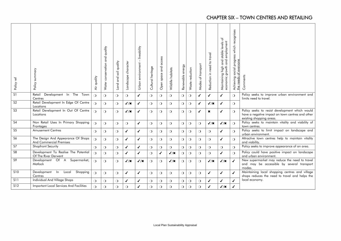
Local Plan Sustainability Appraisal
CHAPTER SIX – TOWN CENTRES AND RETAILING Po
licy
ref
Polic
y su
mm
ary
Air
qual
ity
Wat
er c
onse
rvat
ion
and
qual
ity
Land
and
soi
l qua
lity
Land
scap
e ch
arac
ter
Urb
an e
nviro
nmen
t – li
veab
ility
Cul
tura
l her
itage
Ope
n sp
ace
and
acce
ss
Wild
life
habi
tats
Re
new
able
ene
rgy
Was
te r
educ
tion
Mod
es o
f tra
nspo
rt
Redu
ctio
n in
nee
d to
trav
el
Mai
ntai
ning
hig
h an
d st
able
leve
ls o
f ec
onom
ic g
row
th a
nd e
mpl
oym
ent
Ach
ievi
ng s
ocia
l pro
gres
s w
hich
rec
ogni
ses
the
need
s of
eve
r yon
e
Com
men
ts
S1 Retail Development In The Town Centres
❍ ❍ ❍ ❍ ✔ ❍ ❍ ❍ ❍ ❍ ✔ ✔ ✔ ❍
S2 Retail Development In Edge Of Centre Locations
❍ ❍ ❍ ✔/✖ ✔ ❍ ❍ ❍ ❍ ❍ ✔ ✔/✖ ✔ ❍
Policy seeks to improve urban environment and limits need to travel.
S3 Retail Development In Out Of Centre Locations
❍ ❍ ❍ ✔/✖ ✔ ❍ ❍ ❍ ❍ ❍ ✔ ✖ ✔ ❍ Policy seeks to resist development which would have a negative impact on town centres and other existing shopping areas.
S4 Non Retail Uses In Primary Shopping Frontages
❍ ❍ ❍ ❍ ✔ ❍ ❍ ❍ ❍ ❍ ❍ ✔/✖ ✔/✖ ❍ Policy seeks to maintain vitality and viability of town centres.
S5 Amusement Centres ❍ ❍ ❍ ✔ ✔ ❍ ❍ ❍ ❍ ❍ ❍ ❍ ✔ ❍ Policy seeks to limit impact on landscape and urban environment.
S6 The Design And Appearance Of Shops And Commercial Premises
❍ ❍ ❍ ✔ ✔ ❍ ❍ ❍ ❍ ❍ ❍ ❍ ✔ ❍ Attractive town centres help to maintain vitality and viability.
S7 Shopfront Security ❍ ❍ ❍ ✔ ✔ ❍ ❍ ❍ ❍ ❍ ❍ ❍ ❍ ❍ Policy seeks to improve appearance of an area.
S8 Development To Realise The Potential Of The River Derwent
❍ ❍ ❍ ✔ ✔ ❍ ✔ ✔/✖ ❍ ❍ ❍ ❍ ✔ ❍ Policy could have positive impact on landscape and urban environment.
S9 Development Of A Supermarket, Matlock
❍ ❍ ❍ ✔/✖ ✔/✖ ❍ ❍ ✔/✖ ❍ ❍ ❍ ✔/✖ ✔/✖ ✔ New supermarket may reduce the need to travel and may be accessible by several transport modes.
S10 Development In Local Shopping Centres
❍ ❍ ❍ ✔ ✔ ❍ ❍ ❍ ❍ ❍ ❍ ✔ ✔ ✔
S11 Individual And Village Shops ❍ ❍ ❍ ✔ ✔ ❍ ❍ ❍ ❍ ❍ ❍ ✔ ✔ ✔ S12 Important Local Services And Facilities ❍ ❍ ❍ ❍ ✔ ❍ ❍ ❍ ❍ ❍ ❍ ✔ ✔/✖ ✔
Maintaining local shopping centres and village shops reduces the need to travel and helps the local economy.
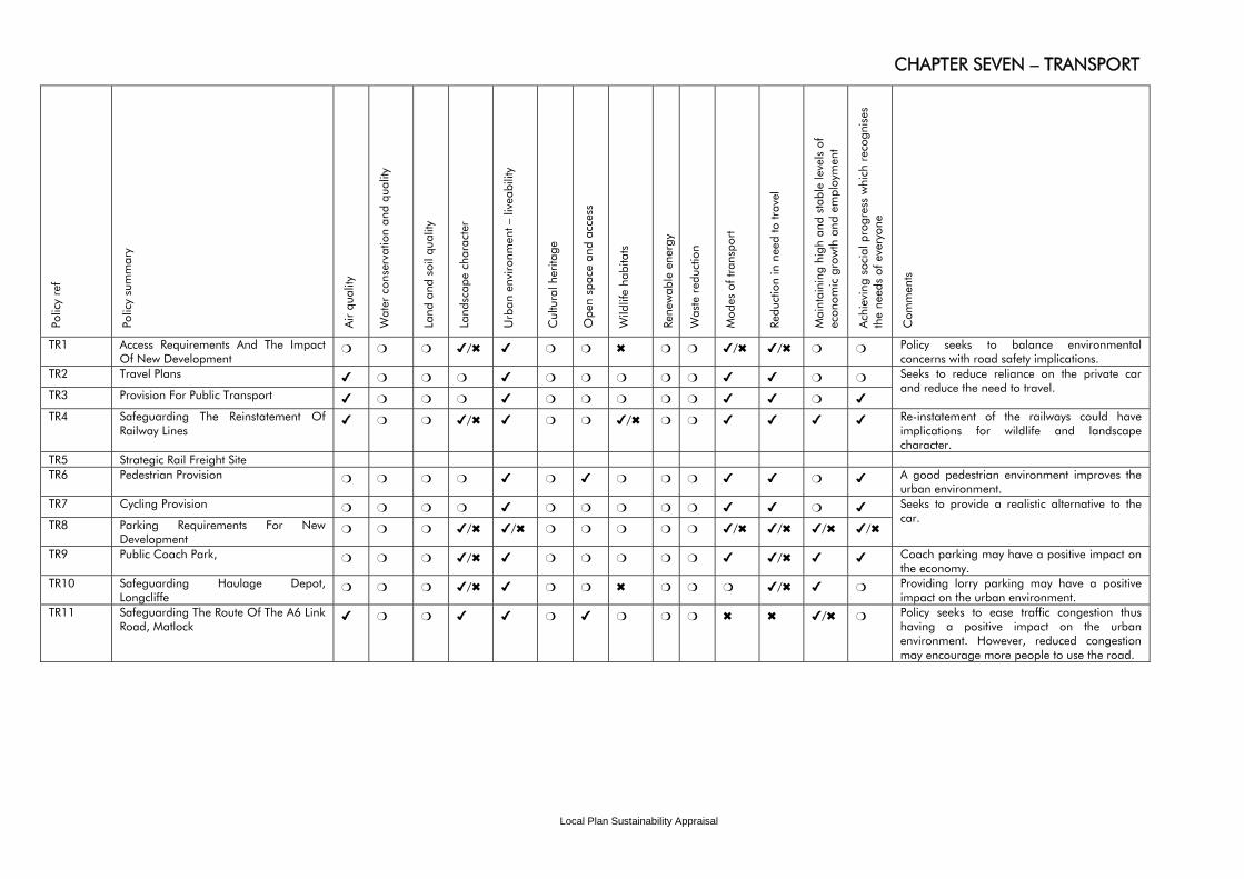
Local Plan Sustainability Appraisal
CHAPTER SEVEN – TRANSPORT Po
licy
ref
Polic
y su
mm
ary
Air
qual
ity
Wat
er c
onse
rvat
ion
and
qual
ity
Land
and
soi
l qua
lity
Land
scap
e ch
arac
ter
Urb
an e
nviro
nmen
t – li
veab
ility
Cul
tura
l her
itage
Ope
n sp
ace
and
acce
ss
Wild
life
habi
tats
Re
new
able
ene
rgy
Was
te r
educ
tion
Mod
es o
f tra
nspo
rt
Redu
ctio
n in
nee
d to
trav
el
Mai
ntai
ning
hig
h an
d st
able
leve
ls o
f ec
onom
ic g
row
th a
nd e
mpl
oym
ent
Ach
ievi
ng s
ocia
l pro
gres
s w
hich
rec
ogni
ses
the
need
s of
eve
ryon
e
Com
men
ts
TR1 Access Requirements And The Impact Of New Development
❍ ❍ ❍ ✔/✖ ✔ ❍ ❍ ✖ ❍ ❍ ✔/✖ ✔/✖ ❍ ❍ Policy seeks to balance environmental concerns with road safety implications.
TR2 Travel Plans ✔ ❍ ❍ ❍ ✔ ❍ ❍ ❍ ❍ ❍ ✔ ✔ ❍ ❍
TR3 Provision For Public Transport ✔ ❍ ❍ ❍ ✔ ❍ ❍ ❍ ❍ ❍ ✔ ✔ ❍ ✔
Seeks to reduce reliance on the private car and reduce the need to travel.
TR4 Safeguarding The Reinstatement Of Railway Lines
✔ ❍ ❍ ✔/✖ ✔ ❍ ❍ ✔/✖ ❍ ❍ ✔ ✔ ✔ ✔ Re-instatement of the railways could have implications for wildlife and landscape character.
TR5 Strategic Rail Freight Site TR6 Pedestrian Provision ❍ ❍ ❍ ❍ ✔ ❍ ✔ ❍ ❍ ❍ ✔ ✔ ❍ ✔ A good pedestrian environment improves the
urban environment. TR7 Cycling Provision ❍ ❍ ❍ ❍ ✔ ❍ ❍ ❍ ❍ ❍ ✔ ✔ ❍ ✔ TR8 Parking Requirements For New
Development ❍ ❍ ❍ ✔/✖ ✔/✖ ❍ ❍ ❍ ❍ ❍ ✔/✖ ✔/✖ ✔/✖ ✔/✖
Seeks to provide a realistic alternative to the car.
TR9 Public Coach Park, ❍ ❍ ❍ ✔/✖ ✔ ❍ ❍ ❍ ❍ ❍ ✔ ✔/✖ ✔ ✔ Coach parking may have a positive impact on the economy.
TR10 Safeguarding Haulage Depot, Longcliffe
❍ ❍ ❍ ✔/✖ ✔ ❍ ❍ ✖ ❍ ❍ ❍ ✔/✖ ✔ ❍ Providing lorry parking may have a positive impact on the urban environment.
TR11 Safeguarding The Route Of The A6 Link Road, Matlock
✔ ❍ ❍ ✔ ✔ ❍ ✔ ❍ ❍ ❍ ✖ ✖ ✔/✖ ❍ Policy seeks to ease traffic congestion thus having a positive impact on the urban environment. However, reduced congestion may encourage more people to use the road.
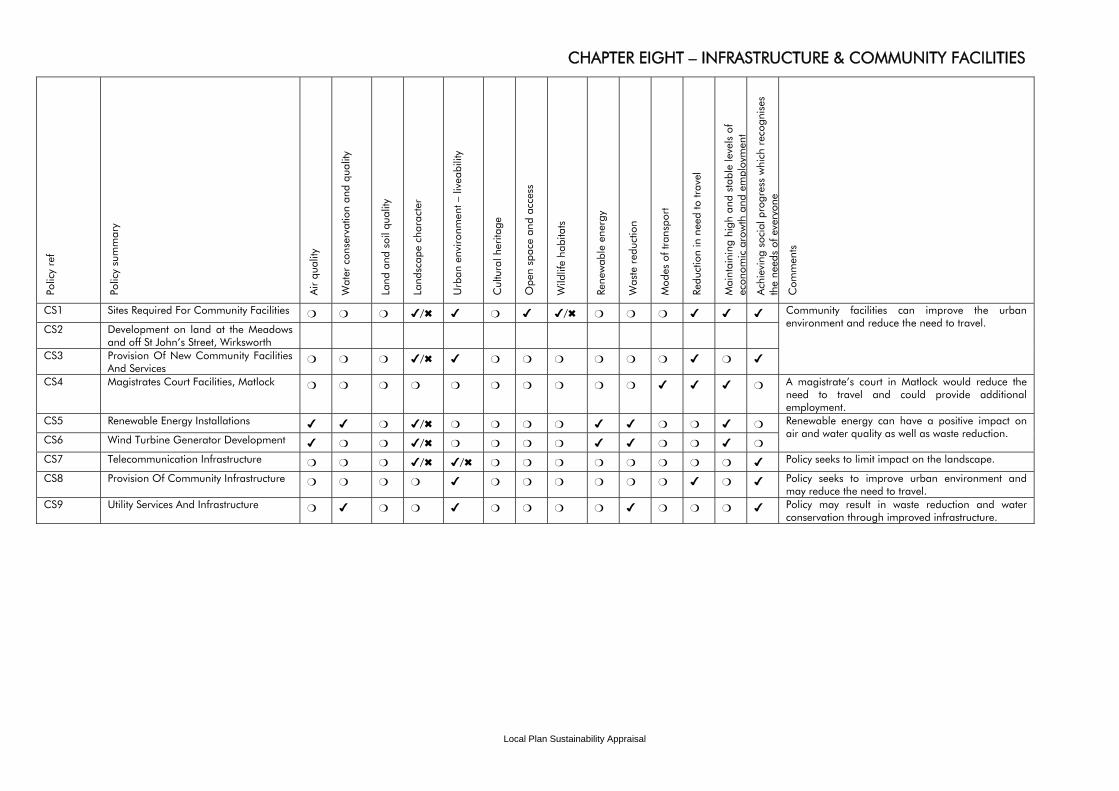
Local Plan Sustainability Appraisal
CHAPTER EIGHT – INFRASTRUCTURE & COMMUNITY FACILITIES Po
licy
ref
Polic
y su
mm
ary
Air
qual
ity
Wat
er c
onse
rvat
ion
and
qual
ity
Land
and
soi
l qua
lity
Land
scap
e ch
arac
ter
Urb
an e
nviro
nmen
t – li
veab
ility
Cul
tura
l her
itage
Ope
n sp
ace
and
acce
ss
Wild
life
habi
tats
Re
new
able
ene
rgy
Was
te r
educ
tion
Mod
es o
f tra
nspo
rt
Redu
ctio
n in
nee
d to
trav
el
Mai
ntai
ning
hig
h an
d st
able
leve
ls o
f ec
onom
ic g
row
th a
nd e
mpl
oym
ent
Ach
ievi
ng s
ocia
l pro
gres
s w
hich
rec
ogni
ses
the
need
s of
eve
r yon
e
Com
men
ts
CS1 Sites Required For Community Facilities ❍ ❍ ❍ ✔/✖ ✔ ❍ ✔ ✔/✖ ❍ ❍ ❍ ✔ ✔ ✔
CS2 Development on land at the Meadows and off St John’s Street, Wirksworth
CS3 Provision Of New Community Facilities And Services
❍ ❍ ❍ ✔/✖ ✔ ❍ ❍ ❍ ❍ ❍ ❍ ✔ ❍ ✔
Community facilities can improve the urban environment and reduce the need to travel.
CS4 Magistrates Court Facilities, Matlock ❍ ❍ ❍ ❍ ❍ ❍ ❍ ❍ ❍ ❍ ✔ ✔ ✔ ❍ A magistrate’s court in Matlock would reduce the need to travel and could provide additional employment.
CS5 Renewable Energy Installations ✔ ✔ ❍ ✔/✖ ❍ ❍ ❍ ❍ ✔ ✔ ❍ ❍ ✔ ❍ CS6 Wind Turbine Generator Development ✔ ❍ ❍ ✔/✖ ❍ ❍ ❍ ❍ ✔ ✔ ❍ ❍ ✔ ❍
Renewable energy can have a positive impact on air and water quality as well as waste reduction.
CS7 Telecommunication Infrastructure ❍ ❍ ❍ ✔/✖ ✔/✖ ❍ ❍ ❍ ❍ ❍ ❍ ❍ ❍ ✔ Policy seeks to limit impact on the landscape.
CS8 Provision Of Community Infrastructure ❍ ❍ ❍ ❍ ✔ ❍ ❍ ❍ ❍ ❍ ❍ ✔ ❍ ✔ Policy seeks to improve urban environment and may reduce the need to travel.
CS9 Utility Services And Infrastructure ❍ ✔ ❍ ❍ ✔ ❍ ❍ ❍ ❍ ✔ ❍ ❍ ❍ ✔ Policy may result in waste reduction and water conservation through improved infrastructure.
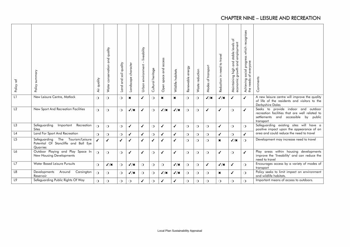
Local Plan Sustainability Appraisal
CHAPTER NINE – LEISURE AND RECREATION Po
licy
ref
Polic
y su
mm
ary
Air
qual
ity
Wat
er c
onse
rvat
ion
and
qual
ity
Land
and
soi
l qua
lity
Land
scap
e ch
arac
ter
Urb
an e
nviro
nmen
t – li
veab
ility
Cul
tura
l her
itage
Ope
n sp
ace
and
acce
ss
Wild
life
habi
tats
Re
new
able
ene
rgy
Was
te r
educ
tion
Mod
es o
f tra
nspo
rt
Redu
ctio
n in
nee
d to
trav
el
Mai
ntai
ning
hig
h an
d st
able
leve
ls o
f ec
onom
ic g
row
th a
nd e
mpl
oym
ent
Ach
ievi
ng s
ocia
l pro
gres
s w
hich
rec
ogni
ses
the
need
s of
eve
ryon
e
Com
men
ts
L1 New Leisure Centre, Matlock ❍ ❍ ❍ ✖ ✔ ❍ ✖ ✖ ❍ ❍ ✔/✖ ✔/✖ ✔ ✔ A new leisure centre will improve the quality of life of the residents and visitors to the Derbyshire Dales
L2 New Sport And Recreation Facilities ❍ ❍ ❍ ✔/✖ ✔ ❍ ✔/✖ ✔/✖ ❍ ❍ ✔ ✔ ❍ ✔ Seeks to provide indoor and outdoor recreation facilities that are well related to settlements and accessible by public transport
L3 Safeguarding Important Recreation Sites
❍ ❍ ❍ ✔ ✔ ❍ ✔ ✔ ❍ ❍ ❍ ✔ ❍ ❍
L4 Land For Sport And Recreation ❍ ❍ ❍ ✔ ✔ ❍ ✔ ✔ ❍ ❍ ❍ ✔ ❍ ✔
Safeguarding existing sites will have a positive impact upon the appearance of an area and could reduce the need to travel
L5 Safeguarding The Tourism/Leisure Potential Of Stancliffe and Ball Eye Quarries
✔ ✔ ✔ ✔ ✔ ✔ ✔ ✔ ❍ ❍ ❍ ✖ ✔/✖ ❍ Development may increase need to travel
L6 Outdoor Playing and Play Space In New Housing Developments
❍ ❍ ❍ ✔ ✔ ❍ ✔ ✔ ❍ ❍ ❍ ✔ ❍ ✔ Play areas within housing developments improve the ‘liveability’ and can reduce the need to travel
L7 Water Based Leisure Pursuits ❍ ✔/✖ ❍ ✔/✖ ❍ ❍ ❍ ✔/✖ ❍ ❍ ✔ ✔/✖ ✔ ❍ Encourages access by a variety of modes of transport
L8 Developments Around Carsington Reservoir
❍ ❍ ❍ ✔/✖ ❍ ❍ ✔/✖ ✔/✖ ❍ ❍ ❍ ✖ ✔ ❍ Policy seeks to limit impact on environment and wildlife habitats.
L9 Safeguarding Public Rights Of Way ❍ ❍ ❍ ❍ ✔ ❍ ✔ ✔ ❍ ❍ ❍ ❍ ❍ ❍ Important means of access to outdoors.
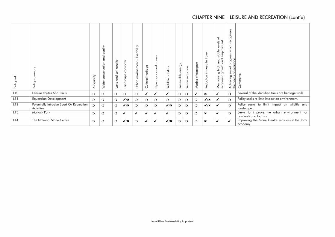
Local Plan Sustainability Appraisal
CHAPTER NINE – LEISURE AND RECREATION (cont’d) Po
licy
ref
Polic
y su
mm
ary
Air
qual
ity
Wat
er c
onse
rvat
ion
and
qual
ity
Land
and
soi
l qua
lity
Land
scap
e ch
arac
ter
Urb
an e
nviro
nmen
t – li
veab
ility
Cul
tura
l her
itage
Ope
n sp
ace
and
acce
ss
Wild
life
habi
tats
Re
new
able
ene
rgy
Was
te r
educ
tion
Mod
es o
f tra
nspo
rt
Redu
ctio
n in
nee
d to
trav
el
Mai
ntai
ning
hig
h an
d st
able
leve
ls o
f ec
onom
ic g
row
th a
nd e
mpl
oym
ent
Ach
ievi
ng s
ocia
l pro
gres
s w
hich
rec
ogni
ses
the
need
s of
eve
r yon
e
Com
men
ts
L10 Leisure Routes And Trails ❍ ❍ ❍ ❍ ❍ ✔ ✔ ✔ ❍ ❍ ✔ ✖ ✔ ❍ Several of the identified trails are heritage trails
L11 Equestrian Development ❍ ❍ ❍ ✔/✖ ❍ ❍ ❍ ❍ ❍ ❍ ❍ ✔/✖ ✔ ❍ Policy seeks to limit impact on environment.
L12 Potentially Intrusive Sport Or Recreation Activities
❍ ❍ ❍ ✔/✖ ❍ ❍ ❍ ✔/✖ ❍ ❍ ❍ ✔/✖ ✔ ❍ Policy seeks to limit impact on wildlife and landscape.
L13 Matlock Park ❍ ❍ ❍ ✔ ✔ ✔ ✔ ✔ ❍ ❍ ❍ ✖ ✔ ❍ Seeks to improve the urban environment for residents and tourists.
L14 The National Stone Centre ❍ ❍ ❍ ✔/✖ ❍ ✔ ✔ ✔/✖ ❍ ❍ ❍ ✖ ✔ ✔ Improving the Stone Centre may assist the local economy.