Embed Size (px)
Citation preview
6-1
Chapter 6: Shadows
A. INTRODUCTION This chapter assesses whether the Proposed Project would result in new shadows that would adversely impact any nearby sun-sensitive resources, including publicly accessible open spaces, historic resources with sunlight-dependent features, or important natural features. The shadows analysis updates changes in background conditions since the 1992 Riverside South Final Environmental Impact Statement (FEIS) (the 1992 FEIS), and assesses whether the differences in program elements between the current Proposed Project and the development scenario assessed in the 1992 FEIS for Parcels L, M, and N would alter the 1992 FEIS conclusions with respect to shadows.
In May 2010, shortly prior to the completion of the Draft SEIS, a substantive update to the 2001 CEQR Technical Manual was released. With respect to shadows, the 2001 CEQR Technical Manual guidelines provided that an incremental shadow is generally not considered significant when its duration is no longer than 10 minutes at any time of year. The 2010 CEQR Technical Manual indicates that a significant adverse shadow impact generally occurs when direct sunlight is eliminated completely from a resource for longer than 10 minutes at any time of year. In considering the significance of such shadows that would completely eliminate sunlight on a sun-sensitive resource, the 2010 Manual (p. 8-27) refers to factors including utilization of the resource and time of year. Proximity of similar sunlit resources is also a consideration to be taken into account.
The shadow assessment has thus been revised to examine two open space areas where incremental shadow would remove all remaining sunlight for longer than 10 minutes on an analysis day: the Parcel O Plaza and the West End Towers open spaces. The shadows assessment has also been revised to reflect the updated 2010 CEQR Technical Manual guidance recommending that Daylight Saving Time is not used in the analysis.
PRINCIPAL CONCLUSIONS
The Proposed Project would cast new shadows on some surrounding publicly accessible open spaces, including Riverside Park South, the Parcel “O” open space at Riverside South, and the Amsterdam Houses playground, West End Towers open space, as well as certain areas of the Hudson River. Incremental shadow from the Proposed Project would also remove all remaining sunlight for longer than 10 minutes on an analysis day at the Parcel O Plaza and the West End Towers open spaces. The Proposed Project would also, in comparison with the wider and shorter buildings that could be constructed under the No Build Scenario, result in less shadow being cast on some areas of Riverside Park South and the Hudson River. The analysis concluded that in no case was the extent and duration of incremental shadow substantial enough to cause a significant adverse impact, taking into account, among other things, utilization and accessibility of the affected resources, time of year that the effect would occur, and availability of similar sunlit resources.
Riverside Center FSEIS
6-2
B. SUMMARY OF 1992 FEIS FINDINGS The shadows analysis in the 1992 FEIS was included as part of the “Urban Design and Visual Character” chapter. The analysis determined that:
• At 9AM on June 21st, project shadows and those cast by the existing Miller Highway would fall westward onto much of the new waterfront park, but would be greatly reduced by 10:30 AM. They would virtually disappear by noon, except under the Miller Highway. Thus, at the time of the year and times of the day when shadows could be most potentially intrusive, the shadows cast by the proposed project would be virtually unnoticeable.
• At 9 AM on March 21st, shadows cast by the proposed buildings and the existing Miller Highway would cover extensive areas of the waterfront park. These shadows would shorten as the day progresses, except under the highway. The remaining shadows cast in the afternoon would be in areas that are already extensively shaded.
• On December 21st at 9 AM, shadows would cover virtually the entire waterfront park and would remain there until 10:30 AM. Most of the waterfront park would be in sunlight by 1:30 PM, and all of it would be in sunlight by 3PM. At 10:30 AM and noon, certian shadows would be cast on the lower waterfront sections of Riverside Park, west of the Henry Hudson Parkway.
No significant adverse impacts with respect to urban design and visual character, including shadows, were identified in the 1992 FEIS.
C. METHODOLOGY Shadows vary according to time of day and season. Morning and evening shadows are long, while midday shadows are shorter. Shadows in winter, when the sun arcs low across the southern sky, are longer throughout the day than at corresponding times in spring and fall, and in summer the high arc of the sun casts shorter shadows than at any other time of year. Early and late shadows in summer fall much further to the south than early and late shadows in winter.
The first step in the assessment of a project’s shadow impacts is to determine whether project shadows would be long enough to reach any sunlight-sensitive open spaces, natural features, or architectural resources at any time of year. If this preliminary or screening analysis indicates they might, then a detailed shadow analysis is warranted. The detailed analysis determines the extent and duration of project-generated incremental shadows on any sun-sensitive uses and vegetation of open spaces, or sunlight-sensitive features of architectural resources, and assesses the effects of new shadows on such resources.
Following the guidelines of the City Environmental Quality Review (CEQR) Technical Manual, the detialed analysis considers shadows on four representative days of the year: March 21 (equivalent to September 21, the equinoxes); June 21, the summer solstice; May 6 (equivalent to August 6, the midpoints between the equinoxes and summer solstice); and December 21, the winter solstice.
The CEQR methodology does not consider shadows and incremental increases in shadows within 1½ hours of sunrise or sunset to be significant. Therefore, the analysis period on each of the four representative days is between 1½ hours after sunrise and 1½ hours before sunset. Additionally, CEQR does not consider shadows on city streets, sidewalks, and other buildings to be significant.
Chapter 6: Shadows
6-3
ANALYSIS FRAMEWORK
The study area for the shadow analysis is defined by the full extent of the area that could be reached by project shadows during each of the analysis days.
The shadow analysis was performed for the expected year of completion of the project, which is 2018. The analysis conservatively compared the Proposed Project to the future baseline condition described as No Build Scenario 2 in Chapter 1, “Project Description”. In this scenario, the 1992 FEIS approved program for Parcels L and M would be completed, but Parcel N would remain in its current parking use. This is the more conservative of the two future baseline options, because without the 1992 FEIS approved structures on Site N, less baseline shadow would be cast, potentially allowing for more incremental shadow from the project.
The analysis compares shadows that would be cast by the proposed project to those that would be cast in the No Build Scenario to determine the shadow increment that would be caused by the proposed project. The analysis also takes into account shadows cast by existing buildings, as well as those cast by additional developments in the study area expected to be completed by the 2018 build year.
The Proposed Project would create approximately 2.75 acres of new privately owned, publicly accessible open space on the project site. According to CEQR methodology, shadows cast on open spaces that are part of a proposed project are not considered impacts of an action because without the action, the open space would not exist. However, a qualitative discussion of shadows on the new open spaces is included in this analysis.
For the detailed analysis, shadows were modeled using the solar rendering capabilities of MicroStation V8i software. A three-dimensional model of existing buildings and topography around the project site was provided by Fugro EarthData Inc. and augmented by AKRF, Inc. A three-dimensional model of the Proposed Project and various contextual elements was provided by the project sponsor and integrated into the baseline conditions model. Other planned development projects in the study area were added as accurately as available information allowed to correctly model the future baseline conditions.
DETERMINATION OF IMPACT SIGNIFICANCE
According to the CEQR Technical Manual, a significant shadow impact may occur when there is substantial reduction in sunlight to a sun-sensitive use or feature, threatening the survival of vegetation or significantly reducing the usability of the open space, or in the case of an architectural feature, obscuring the elements or details that make that resource significant. The determination of impact significance is based on an assessment of how a project’s incremental shadows specifically would affect sun-sensitive features of individual resources.
D. SCREENING ANALYSIS A screening analysis was performed to determine which open spaces, sunlight-sensitive architectural resources, or important natural features could be affected by project shadows at any time of year. The heights of the proposed buildings were multiplied by the shadow length factors provided in the CEQR Technical Manual for each analysis day in order to determine the full extent of the area that could potentially be reached by project-generated shadow. The maximum shadow lengths for each analysis day were delineated on a street map. In coordination with the open space and historic resources analyses provided in other chapters of this SEIS, any publicly-
Riverside Center FSEIS
6-4
accessible open space, important natural resource and historic resources located within the delineated area was identified.
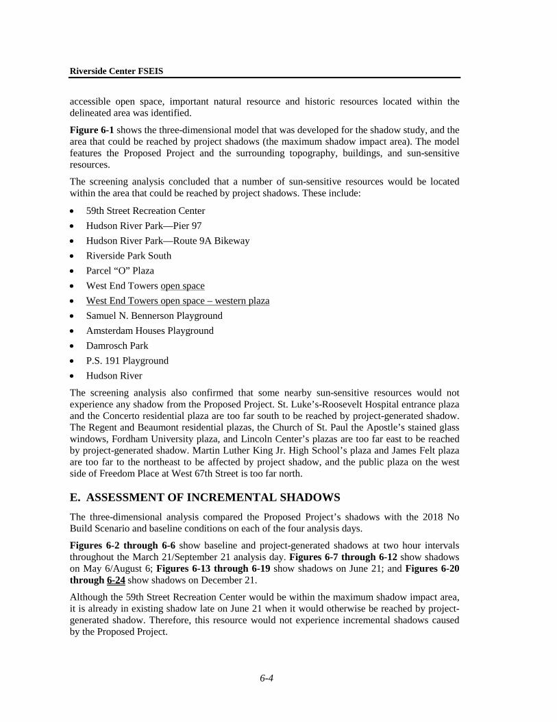
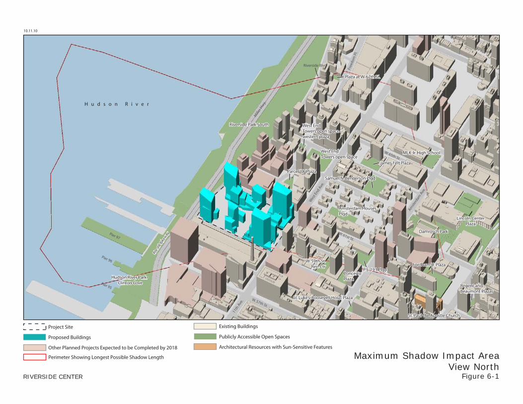
Figure 6-1 shows the three-dimensional model that was developed for the shadow study, and the area that could be reached by project shadows (the maximum shadow impact area). The model features the Proposed Project and the surrounding topography, buildings, and sun-sensitive resources.
The screening analysis concluded that a number of sun-sensitive resources would be located within the area that could be reached by project shadows. These include:
• 59th Street Recreation Center • Hudson River Park—Pier 97 • Hudson River Park—Route 9A Bikeway • Riverside Park South • Parcel “O” Plaza • West End Towers open space • West End Towers open space – western plaza • Samuel N. Bennerson Playground • Amsterdam Houses Playground • Damrosch Park • P.S. 191 Playground • Hudson River
The screening analysis also confirmed that some nearby sun-sensitive resources would not experience any shadow from the Proposed Project. St. Luke’s-Roosevelt Hospital entrance plaza and the Concerto residential plaza are too far south to be reached by project-generated shadow. The Regent and Beaumont residential plazas, the Church of St. Paul the Apostle’s stained glass windows, Fordham University plaza, and Lincoln Center’s plazas are too far east to be reached by project-generated shadow. Martin Luther King Jr. High School’s plaza and James Felt plaza are too far to the northeast to be affected by project shadow, and the public plaza on the west side of Freedom Place at West 67th Street is too far north.
E. ASSESSMENT OF INCREMENTAL SHADOWS The three-dimensional analysis compared the Proposed Project’s shadows with the 2018 No Build Scenario and baseline conditions on each of the four analysis days.
Figures 6-2 through 6-6 show baseline and project-generated shadows at two hour intervals throughout the March 21/September 21 analysis day. Figures 6-7 through 6-12 show shadows on May 6/August 6; Figures 6-13 through 6-19 show shadows on June 21; and Figures 6-20 through 6-24 show shadows on December 21.
Although the 59th Street Recreation Center would be within the maximum shadow impact area, it is already in existing shadow late on June 21 when it would otherwise be reached by project-generated shadow. Therefore, this resource would not experience incremental shadows caused by the Proposed Project.
10.11.10
RIVERSIDE CENTER
Maximum Shadow Impact AreaView North
Figure 6-1
Mill
er H
wy.
Free
dom
Pl.
Riverside Blvd.
Wes
t End A
ve.
Amst
erdam
Ave
.
11th
Ave
. W. 57th St.
W. 65th St.
W. 61st St.
H u d s o n R i v e r
Lincoln CenterPlaza
Damrosch Park
Riverside Park South
Plaza at W. 67th St.
West EndTowers open space
MLK Jr. High School
James Felt Plaza
Amsterdam HousesPlgd
Samuel N. Bennerson Plgd
P.S. 191 Plgd
W. 59th St.Rec. Ctr
ConcertoPlaza
Parcel “O” Plaza
Regent andBeaumont Plazas
St. Luke’s-Roosevelt Hosp. Plaza
Fordham U. Plaza
St. Paul the Apostle Church
Hudson River Park -Clinton Cove
Pier 97
Pier 96
Pier 95
Rte.
9A B
ikew
ay
West EndTowers open space -western plaza
Proposed Buildings
Other Planned Projects Expected to be Completed by 2018
Project Site
Publicly Accessible Open Spaces
Architectural Resources with Sun-Sensitive Features
Existing Buildings
Perimeter Showing Longest Possible Shadow Length
Mill
er H
wy.
Free
dom
Pl. S
outh
Riversi
de Blvd
.
Wes
t End
Ave
.
Amst
erda
m A
ve.
W. 65th St.
W. 61st St.Pier 97
W. 64th St.
W. 60th St.
W. 59th St.
W. 58th St.
H u d s o n R i v e r
Damrosch Park
Riverside Park South
West EndTowers open space
James Felt Plaza
Amsterdam HousesPlgd
Samuel N. BennersonPlgd
P.S. 191 Plgd
W. 59th St.Rec. Ctr
Parcel “O” Plaza
Hudson River Park -Clinton Cove
Building 1
Building 2Building 3
Building 4
Building 5
TotPlay*
ClimbingWall*
Amphi-theater*Lawn*
Lawn*
Wal
kway
s, la
wns
, pla
ntin
gs
* proposed according to Riverside Park South Master Plan
Proposed open space
Rout
e 9A
Bik
eway
West EndTowers open space -western plaza
10.11.10
RIVERSIDE CENTER
ShadowsMarch 21 / Sept. 21 - 8:00 AM EST
Figure 6-2
shadowangle
Publicly Accessible Open Spaces
Incremental ShadowProposed Buildings
Other Planned Projects Expected to be Completed by 2018
Project Site
Existing Buildings
Reduction in Shadow
SCALE
0 200 500 FEET
Mill
er H
wy.
Free
dom
Pl. S
outh
Riversi
de Blvd
.
Wes
t End
Ave
.
Amst
erda
m A
ve.
W. 65th St.
W. 61st St.Pier 97
W. 64th St.
W. 60th St.
W. 59th St.
W. 58th St.
H u d s o n R i v e r
Damrosch Park
Riverside Park South
James Felt Plaza
Amsterdam HousesPlgd
Samuel N. BennersonPlgd
P.S. 191 Plgd
W. 59th St.Rec. Ctr
Hudson River Park -Clinton Cove
Building 1
Building 2Building 3
Building 4
Building 5
TotPlay*
ClimbingWall*
Amphi-theater*Lawn*
Lawn*
Wal
kway
s, la
wns
, pla
ntin
gs
* proposed according to Riverside Park South Master Plan
Proposed open space
Rout
e 9A
Bik
eway
West EndTowers open space
Parcel “O” Plaza
West EndTowers open space -western plaza
10.11.10
RIVERSIDE CENTER
ShadowsMarch 21 / Sept. 21 - 10:00 AM EST
Figure 6-3
shadowangle
Publicly Accessible Open Spaces
Incremental ShadowProposed Buildings
Other Planned Projects Expected to be Completed by 2018
Project Site
Existing Buildings
Reduction in Shadow
SCALE
0 200 500 FEET
Mill
er H
wy.
Free
dom
Pl. S
outh
Riversi
de Blvd
.
Wes
t End
Ave
.
Amst
erda
m A
ve.
W. 65th St.
W. 61st St.Pier 97
W. 64th St.
W. 60th St.
W. 59th St.
W. 58th St.
H u d s o n R i v e r
Damrosch Park
Riverside Park South
James Felt Plaza
Amsterdam HousesPlgd
Samuel N. BennersonPlgd
P.S. 191 Plgd
W. 59th St.Rec. Ctr
Hudson River Park -Clinton Cove
Building 1
Building 2Building 3
Building 4
Building 5
TotPlay*
ClimbingWall*
Amphi-theater*Lawn*
Lawn*
Wal
kway
s, la
wns
, pla
ntin
gs
* proposed according to Riverside Park South Master Plan
Proposed open space
Rout
e 9A
Bik
eway
West EndTowers open space
Parcel “O” Plaza
West EndTowers open space -western plaza
10.11.10
RIVERSIDE CENTER
ShadowsMarch 21 / Sept. 21 - 12:00 PM EST
Figure 6-4
shadowangle
Publicly Accessible Open Spaces
Incremental ShadowProposed Buildings
Other Planned Projects Expected to be Completed by 2018
Project Site
Existing Buildings
Reduction in Shadow
SCALE
0 200 500 FEET
Mill
er H
wy.
Free
dom
Pl. S
outh
Riversi
de Blvd
.
Wes
t End
Ave
.
Amst
erda
m A
ve.
W. 65th St.
W. 61st St.Pier 97
W. 64th St.
W. 60th St.
W. 59th St.
W. 58th St.
H u d s o n R i v e r
Damrosch Park
Riverside Park South
James Felt Plaza
Amsterdam HousesPlgd
Samuel N. BennersonPlgd
P.S. 191 Plgd
W. 59th St.Rec. Ctr
Hudson River Park -Clinton Cove
Building 1
Building 2Building 3
Building 4
Building 5
TotPlay*
ClimbingWall*
Amphi-theater*Lawn*
Lawn*
Wal
kway
s, la
wns
, pla
ntin
gs
* proposed according to Riverside Park South Master Plan
Proposed open space
Rout
e 9A
Bik
eway
West EndTowers open space
Parcel “O” Plaza
West EndTowers open space -western plaza
10.11.10
RIVERSIDE CENTER
ShadowsMarch 21 / Sept. 21 - 2:00 PM EST
Figure 6-5
shadowangle
Publicly Accessible Open Spaces
Proposed Buildings
Other Planned Projects Expected to be Completed by 2018
Project Site
Existing Buildings
Incremental ShadowSCALE
0 200 500 FEET
Mill
er H
wy.
Free
dom
Pl. S
outh
Riversi
de Blvd
.
Wes
t End
Ave
.
Amst
erda
m A
ve.
W. 65th St.
W. 61st St.Pier 97
W. 64th St.
W. 60th St.
W. 59th St.
W. 58th St.
H u d s o n R i v e r
Damrosch Park
Riverside Park South
James Felt Plaza
Amsterdam HousesPlgd
Samuel N. BennersonPlgd
P.S. 191 Plgd
W. 59th St.Rec. Ctr
Hudson River Park -Clinton Cove
Building 1
Building 2Building 3
Building 4
Building 5
TotPlay*
ClimbingWall*
Amphi-theater*Lawn*
Lawn*
Wal
kway
s, la
wns
, pla
ntin
gs
* proposed according to Riverside Park South Master Plan
Proposed open space
Rout
e 9A
Bik
eway
West EndTowers open space
Parcel “O” Plaza
West EndTowers open space -western plaza
10.11.10
RIVERSIDE CENTER
ShadowsMarch 21 / Sept. 21 - 4:00 PM EST
Figure 6-6
shadowangle
Publicly Accessible Open Spaces
Incremental ShadowProposed Buildings
Other Planned Projects Expected to be Completed by 2018
Project Site
Existing Buildings
SCALE
0 200 500 FEET
Mill
er H
wy.
Free
dom
Pl. S
outh
Riversi
de Blvd
.
Wes
t End
Ave
.
Amst
erda
m A
ve.
W. 65th St.
W. 61st St.Pier 97
W. 64th St.
W. 60th St.
W. 59th St.
W. 58th St.
H u d s o n R i v e r
Damrosch Park
Riverside Park South
James Felt Plaza
Amsterdam HousesPlgd
Samuel N. BennersonPlgd
P.S. 191 Plgd
W. 59th St.Rec. Ctr
Hudson River Park -Clinton Cove
Building 1
Building 2Building 3
Building 4
Building 5
TotPlay*
ClimbingWall*
Amphi-theater*Lawn*
Lawn*
Wal
kway
s, la
wns
, pla
ntin
gs
* proposed according to Riverside Park South Master Plan
Proposed open space
Rout
e 9A
Bik
eway
West EndTowers open space
Parcel “O” Plaza
West EndTowers open space -western plaza
10.11.10
RIVERSIDE CENTER
ShadowsMay 6 / August 6 - 7:00 AM EST
Figure 6-7
shadowangle
Publicly Accessible Open Spaces
Proposed Buildings
Other Planned Projects Expected to be Completed by 2018
Project Site
Existing Buildings
Reduction in Shadow
Incremental Shadow SCALE
0 200 500 FEET
Mill
er H
wy.
Free
dom
Pl. S
outh
Riversi
de Blvd
.
Wes
t End
Ave
.
Amst
erda
m A
ve.
W. 65th St.
W. 61st St.Pier 97
W. 64th St.
W. 60th St.
W. 59th St.
W. 58th St.
H u d s o n R i v e r
Damrosch Park
Riverside Park South
James Felt Plaza
Amsterdam HousesPlgd
Samuel N. BennersonPlgd
P.S. 191 Plgd
W. 59th St.Rec. Ctr
Hudson River Park -Clinton Cove
Building 1
Building 2Building 3
Building 4
Building 5
TotPlay*
ClimbingWall*
Amphi-theater*Lawn*
Lawn*
Wal
kway
s, la
wns
, pla
ntin
gs
* proposed according to Riverside Park South Master Plan
Proposed open space
Rout
e 9A
Bik
eway
West EndTowers open space
Parcel “O” Plaza
West EndTowers open space -western plaza
10.11.10
RIVERSIDE CENTER
ShadowsMay 6 / August 6 - 9:00 AM EST
Figure 6-8
shadowangle
Publicly Accessible Open Spaces
Proposed Buildings
Other Planned Projects Expected to be Completed by 2018
Project Site
Existing Buildings
Reduction in Shadow
Incremental Shadow SCALE
0 200 500 FEET
Mill
er H
wy.
Free
dom
Pl. S
outh
Riversi
de Blvd
.
Wes
t End
Ave
.
Amst
erda
m A
ve.
W. 65th St.
W. 61st St.Pier 97
W. 64th St.
W. 60th St.
W. 59th St.
W. 58th St.
H u d s o n R i v e r
Damrosch Park
Riverside Park South
James Felt Plaza
Amsterdam HousesPlgd
Samuel N. BennersonPlgd
P.S. 191 Plgd
W. 59th St.Rec. Ctr
Hudson River Park -Clinton Cove
Building 1
Building 2Building 3
Building 4
Building 5
TotPlay*
ClimbingWall*
Amphi-theater*Lawn*
Lawn*
Wal
kway
s, la
wns
, pla
ntin
gs
* proposed according to Riverside Park South Master Plan
Proposed open space
Rout
e 9A
Bik
eway
West EndTowers open space
Parcel “O” Plaza
West EndTowers open space -western plaza
10.11.10
RIVERSIDE CENTER
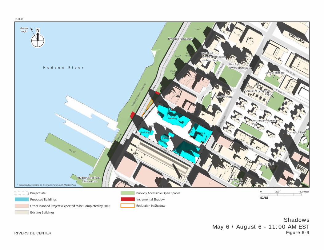
ShadowsMay 6 / August 6 - 11:00 AM EST
Figure 6-9
shadowangle
Publicly Accessible Open Spaces
Proposed Buildings
Other Planned Projects Expected to be Completed by 2018
Project Site
Existing Buildings
Reduction in Shadow
Incremental Shadow SCALE
0 200 500 FEET
Mill
er H
wy.
Free
dom
Pl. S
outh
Riversi
de Blvd
.
Wes
t End
Ave
.
Amst
erda
m A
ve.
W. 65th St.
W. 61st St.Pier 97
W. 64th St.
W. 60th St.
W. 59th St.
W. 58th St.
H u d s o n R i v e r
Damrosch Park
Riverside Park South
James Felt Plaza
Amsterdam HousesPlgd
Samuel N. BennersonPlgd
P.S. 191 Plgd
W. 59th St.Rec. Ctr
Hudson River Park -Clinton Cove
Building 1
Building 2Building 3
Building 4
Building 5
TotPlay*
ClimbingWall*
Amphi-theater*Lawn*
Lawn*
Wal
kway
s, la
wns
, pla
ntin
gs
* proposed according to Riverside Park South Master Plan
Proposed open space
Rout
e 9A
Bik
eway
West EndTowers open space
Parcel “O” Plaza
West EndTowers open space -western plaza
10.11.10
RIVERSIDE CENTER
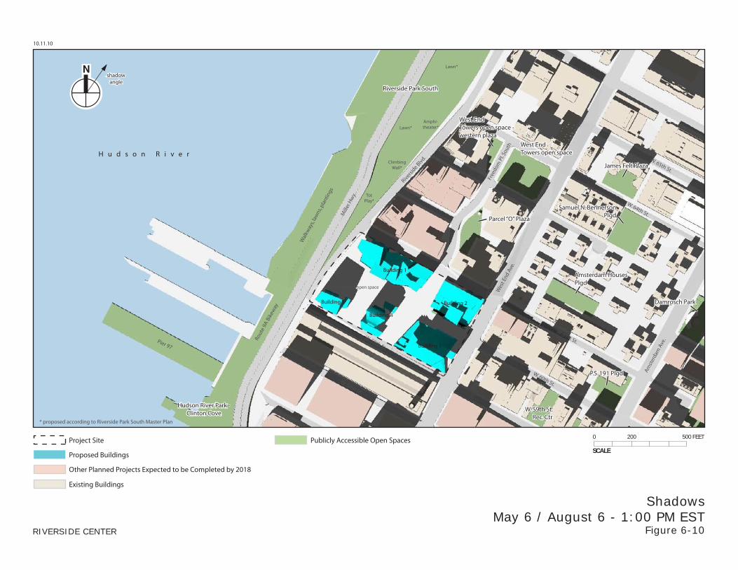
ShadowsMay 6 / August 6 - 1:00 PM EST
Figure 6-10
shadowangle
Publicly Accessible Open Spaces
Proposed Buildings
Other Planned Projects Expected to be Completed by 2018
Project Site
Existing Buildings
SCALE
0 200 500 FEET
Mill
er H
wy.
Free
dom
Pl. S
outh
Riversi
de Blvd
.
Wes
t End
Ave
.
Amst
erda
m A
ve.
W. 65th St.
W. 61st St.Pier 97
W. 64th St.
W. 60th St.
W. 59th St.
W. 58th St.
H u d s o n R i v e r
Damrosch Park
Riverside Park South
James Felt Plaza
Amsterdam HousesPlgd
Samuel N. BennersonPlgd
P.S. 191 Plgd
W. 59th St.Rec. Ctr
Hudson River Park -Clinton Cove
Building 1
Building 2Building 3
Building 4
Building 5
TotPlay*
ClimbingWall*
Amphi-theater*Lawn*
Lawn*
Wal
kway
s, la
wns
, pla
ntin
gs
* proposed according to Riverside Park South Master Plan
Proposed open space
Rout
e 9A
Bik
eway
West EndTowers open space
Parcel “O” Plaza
West EndTowers open space -western plaza
10.11.10
RIVERSIDE CENTER
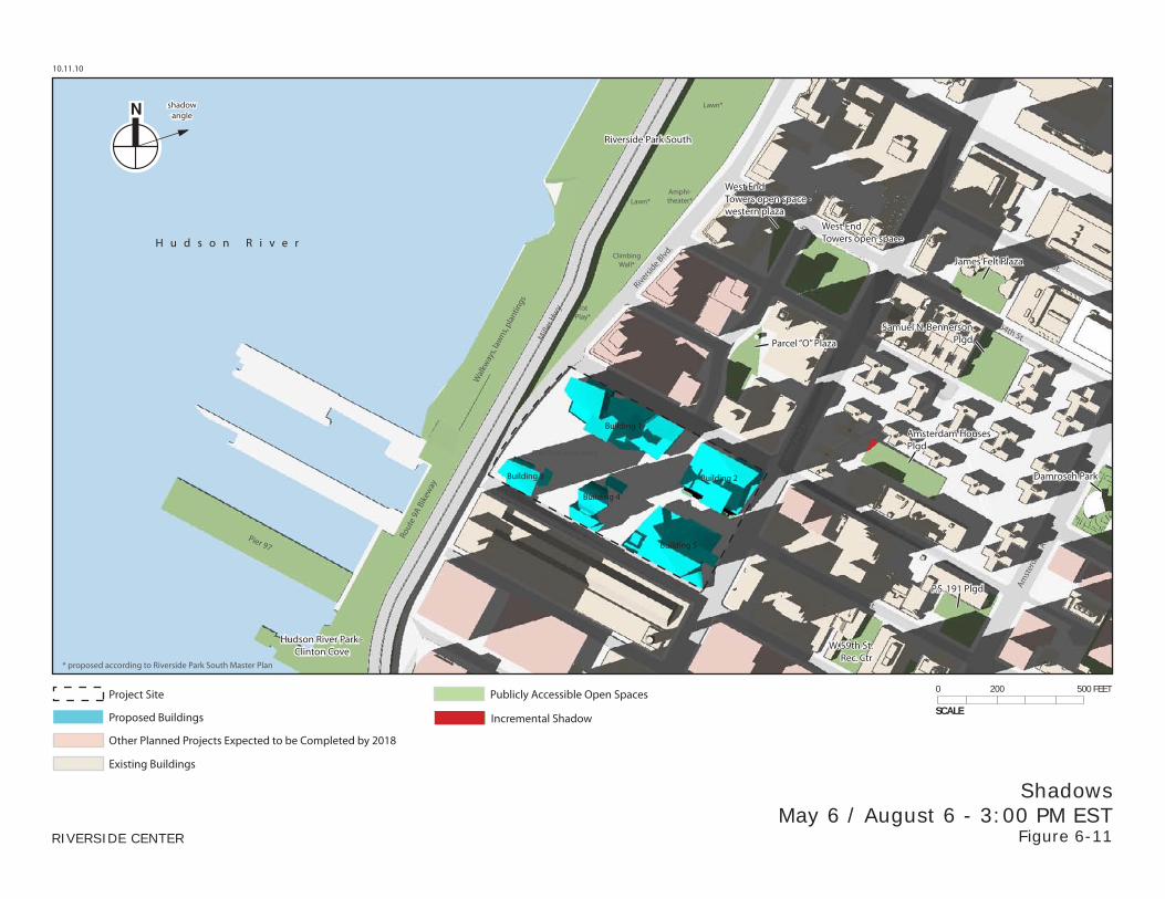
ShadowsMay 6 / August 6 - 3:00 PM EST
Figure 6-11
shadowangle
Publicly Accessible Open Spaces
Proposed Buildings
Other Planned Projects Expected to be Completed by 2018
Project Site
Existing Buildings
Incremental ShadowSCALE
0 200 500 FEET
Mill
er H
wy.
Free
dom
Pl. S
outh
Riversi
de Blvd
.
Wes
t End
Ave
.
Amst
erda
m A
ve.
W. 65th St.
W. 61st St.Pier 97
W. 64th St.
W. 60th St.
W. 59th St.
W. 58th St.
H u d s o n R i v e r
Damrosch Park
Riverside Park South
James Felt Plaza
Amsterdam HousesPlgd
Samuel N. BennersonPlgd
P.S. 191 Plgd
W. 59th St.Rec. Ctr
Hudson River Park -Clinton Cove
Building 1
Building 2Building 3
Building 4
Building 5
TotPlay*
ClimbingWall*
Amphi-theater*Lawn*
Lawn*
Wal
kway
s, la
wns
, pla
ntin
gs
* proposed according to Riverside Park South Master Plan
Proposed open space
Rout
e 9A
Bik
eway
West EndTowers open space
Parcel “O” Plaza
West EndTowers open space -western plaza
10.11.10
RIVERSIDE CENTER
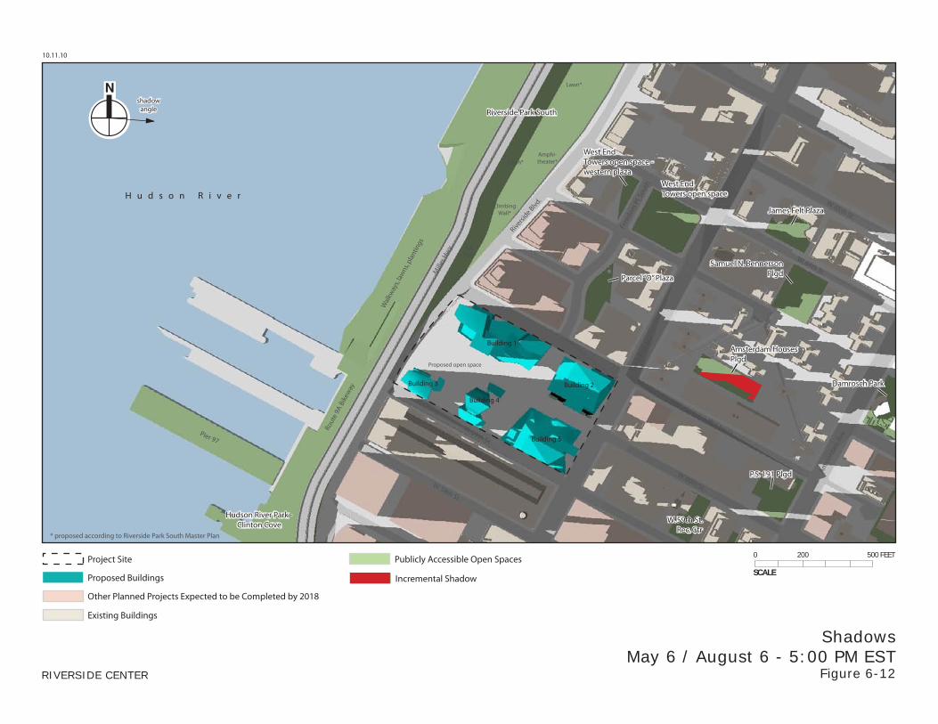
ShadowsMay 6 / August 6 - 5:00 PM EST
Figure 6-12
shadowangle
Publicly Accessible Open Spaces
Proposed Buildings
Other Planned Projects Expected to be Completed by 2018
Project Site
Existing Buildings
Incremental ShadowSCALE
0 200 500 FEET
Mill
er H
wy.
Free
dom
Pl. S
outh
Riversi
de Blvd
.
Wes
t End
Ave
.
Amst
erda
m A
ve.
W. 65th St.
W. 61st St.Pier 97
W. 64th St.
W. 60th St.
W. 59th St.
W. 58th St.
H u d s o n R i v e r
Damrosch Park
Riverside Park South
James Felt Plaza
Amsterdam HousesPlgd
Samuel N. BennersonPlgd
P.S. 191 Plgd
W. 59th St.Rec. Ctr
Hudson River Park -Clinton Cove
Building 1
Building 2Building 3
Building 4
Building 5
TotPlay*
ClimbingWall*
Amphi-theater*Lawn*
Lawn*
Wal
kway
s, la
wns
, pla
ntin
gs
* proposed according to Riverside Park South Master Plan
Proposed open space
Rout
e 9A
Bik
eway
West EndTowers open space
Parcel “O” Plaza
West EndTowers open space -western plaza
10.11.10
RIVERSIDE CENTER
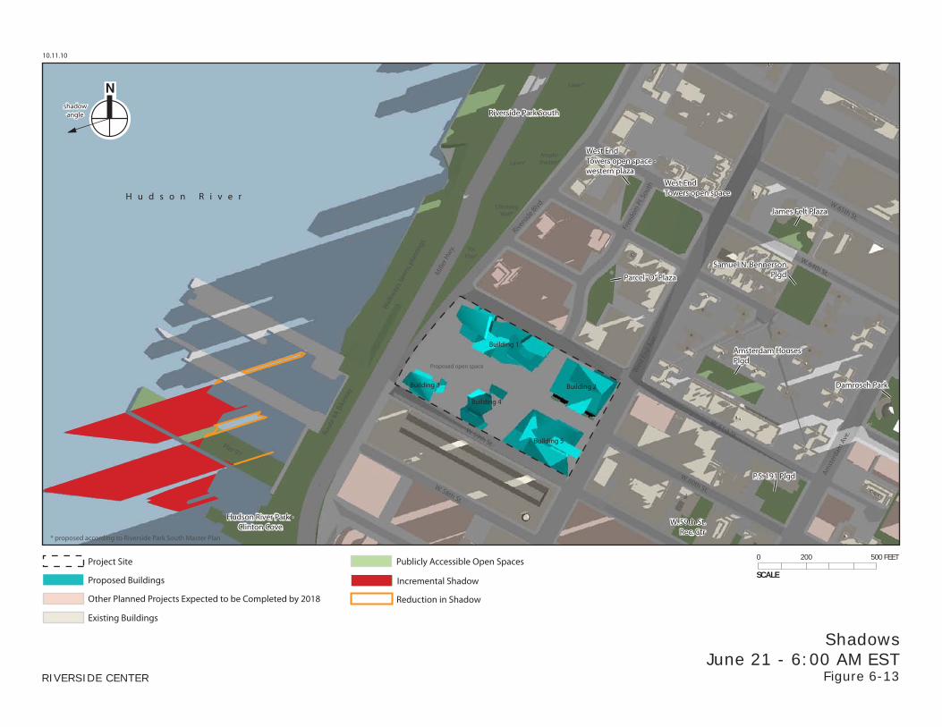
ShadowsJune 21 - 6:00 AM EST
Figure 6-13
shadowangle
Publicly Accessible Open Spaces
Proposed Buildings
Other Planned Projects Expected to be Completed by 2018
Project Site
Existing Buildings
Reduction in Shadow
Incremental ShadowSCALE
0 200 500 FEET
Mill
er H
wy.
Free
dom
Pl. S
outh
Riversi
de Blvd
.
Wes
t End
Ave
.
Amst
erda
m A
ve.
W. 65th St.
W. 61st St.Pier 97
W. 64th St.
W. 60th St.
W. 59th St.
W. 58th St.
H u d s o n R i v e r
Damrosch Park
Riverside Park South
James Felt Plaza
Amsterdam HousesPlgd
Samuel N. BennersonPlgd
P.S. 191 Plgd
W. 59th St.Rec. Ctr
Hudson River Park -Clinton Cove
Building 1
Building 2Building 3
Building 4
Building 5
TotPlay*
ClimbingWall*
Amphi-theater*Lawn*
Lawn*
Wal
kway
s, la
wns
, pla
ntin
gs
* proposed according to Riverside Park South Master Plan
Proposed open space
Rout
e 9A
Bik
eway
West EndTowers open space
Parcel “O” Plaza
West EndTowers open space -western plaza
10.11.10
RIVERSIDE CENTER
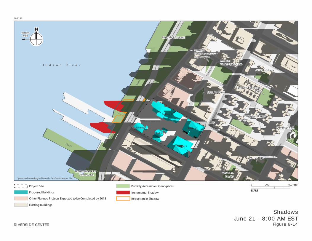
ShadowsJune 21 - 8:00 AM EST
Figure 6-14
shadowangle
Publicly Accessible Open Spaces
Proposed Buildings
Other Planned Projects Expected to be Completed by 2018
Project Site
Existing Buildings
Reduction in Shadow
Incremental ShadowSCALE
0 200 500 FEET
Mill
er H
wy.
Free
dom
Pl. S
outh
Riversi
de Blvd
.
Wes
t End
Ave
.
Amst
erda
m A
ve.
W. 65th St.
W. 61st St.Pier 97
W. 64th St.
W. 60th St.
W. 59th St.
W. 58th St.
H u d s o n R i v e r
Damrosch Park
Riverside Park South
James Felt Plaza
Amsterdam HousesPlgd
Samuel N. BennersonPlgd
P.S. 191 Plgd
W. 59th St.Rec. Ctr
Hudson River Park -Clinton Cove
Building 1
Building 2Building 3
Building 4
Building 5
TotPlay*
ClimbingWall*
Amphi-theater*Lawn*
Lawn*
Wal
kway
s, la
wns
, pla
ntin
gs
* proposed according to Riverside Park South Master Plan
Proposed open space
Rout
e 9A
Bik
eway
West EndTowers open space
Parcel “O” Plaza
West EndTowers open space -western plaza
10.11.10
RIVERSIDE CENTER
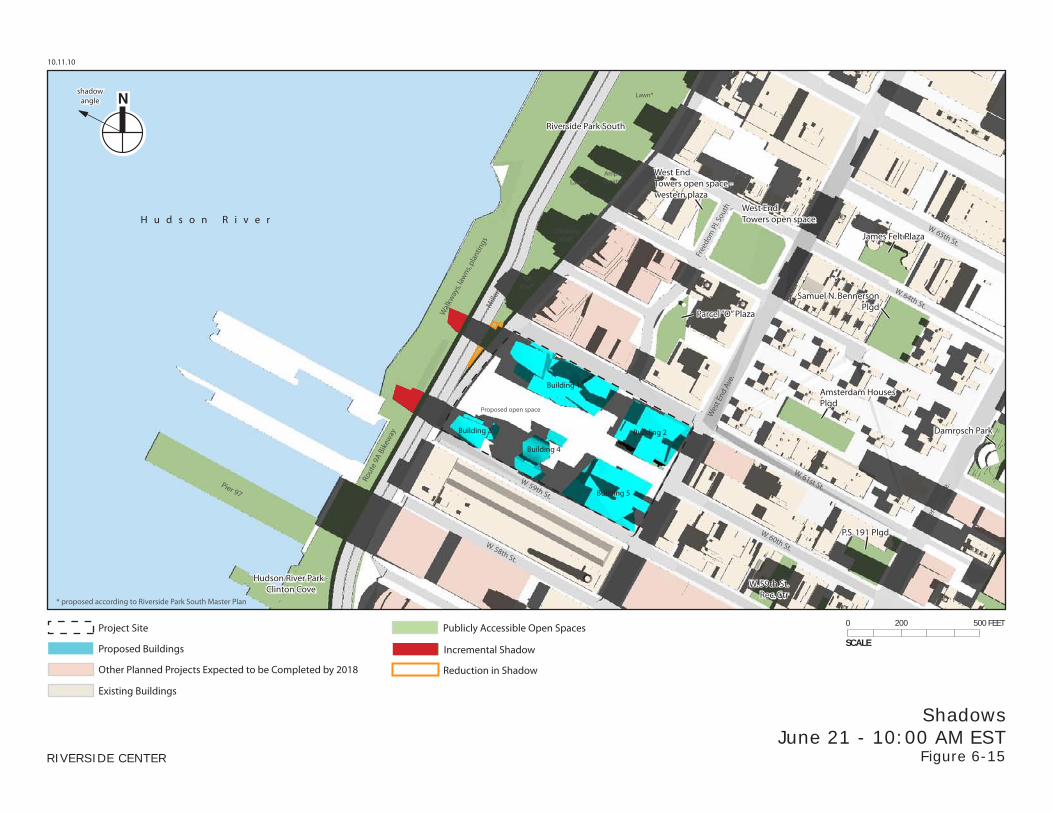
ShadowsJune 21 - 10:00 AM EST
Figure 6-15
shadowangle
Publicly Accessible Open Spaces
Proposed Buildings
Other Planned Projects Expected to be Completed by 2018
Project Site
Existing Buildings
Reduction in Shadow
Incremental ShadowSCALE
0 200 500 FEET
Mill
er H
wy.
Free
dom
Pl. S
outh
Riversi
de Blvd
.
Wes
t End
Ave
.
Amst
erda
m A
ve.
W. 65th St.
W. 61st St.Pier 97
W. 64th St.
W. 60th St.
W. 59th St.
W. 58th St.
H u d s o n R i v e r
Damrosch Park
Riverside Park South
James Felt Plaza
Amsterdam HousesPlgd
Samuel N. BennersonPlgd
P.S. 191 Plgd
W. 59th St.Rec. Ctr
Hudson River Park -Clinton Cove
Building 1
Building 2Building 3
Building 4
Building 5
TotPlay*
ClimbingWall*
Amphi-theater*Lawn*
Lawn*
Wal
kway
s, la
wns
, pla
ntin
gs
* proposed according to Riverside Park South Master Plan
Proposed open space
Rout
e 9A
Bik
eway
West EndTowers open space
Parcel “O” Plaza
West EndTowers open space -western plaza
10.11.10
RIVERSIDE CENTER
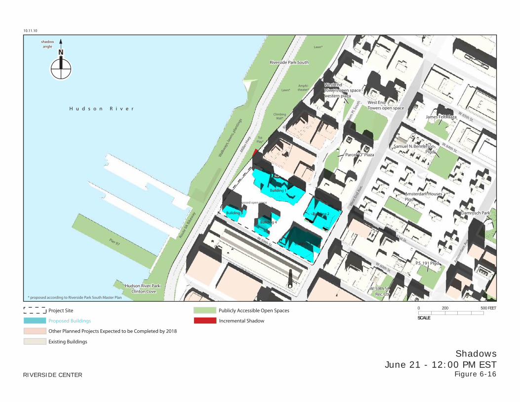
ShadowsJune 21 - 12:00 PM EST
Figure 6-16
shadowangle
Publicly Accessible Open Spaces
Proposed Buildings
Other Planned Projects Expected to be Completed by 2018
Project Site
Existing Buildings
Incremental Shadow SCALE
0 200 500 FEET
Mill
er H
wy.
Free
dom
Pl. S
outh
Riversi
de Blvd
.
Wes
t End
Ave
.
Amst
erda
m A
ve.
W. 65th St.
W. 61st St.Pier 97
W. 64th St.
W. 60th St.
W. 59th St.
W. 58th St.
H u d s o n R i v e r
Damrosch Park
Riverside Park South
James Felt Plaza
Amsterdam HousesPlgd
Samuel N. BennersonPlgd
P.S. 191 Plgd
W. 59th St.Rec. Ctr
Hudson River Park -Clinton Cove
Building 1
Building 2Building 3
Building 4
Building 5
TotPlay*
ClimbingWall*
Amphi-theater*Lawn*
Lawn*
Wal
kway
s, la
wns
, pla
ntin
gs
* proposed according to Riverside Park South Master Plan
Proposed open space
Rout
e 9A
Bik
eway
West EndTowers open space
Parcel “O” Plaza
West EndTowers open space -western plaza
10.11.10
RIVERSIDE CENTER
ShadowsJune 21 - 2:00 PM EST
Figure 6-17
shadowangle
Publicly Accessible Open Spaces
Proposed Buildings
Other Planned Projects Expected to be Completed by 2018
Project Site
Existing Buildings
SCALE
0 200 500 FEET
Mill
er H
wy.
Free
dom
Pl. S
outh
Riversi
de Blvd
.
Wes
t End
Ave
.
Amst
erda
m A
ve.
W. 65th St.
W. 61st St.Pier 97
W. 64th St.
W. 60th St.
W. 59th St.
W. 58th St.
H u d s o n R i v e r
Damrosch Park
Riverside Park South
James Felt Plaza
Amsterdam HousesPlgd
Samuel N. BennersonPlgd
P.S. 191 Plgd
W. 59th St.Rec. Ctr
Hudson River Park -Clinton Cove
Building 1
Building 2Building 3
Building 4
Building 5
TotPlay*
ClimbingWall*
Amphi-theater*Lawn*
Lawn*
Wal
kway
s, la
wns
, pla
ntin
gs
* proposed according to Riverside Park South Master Plan
Proposed open space
Rout
e 9A
Bik
eway
West EndTowers open space
Parcel “O” Plaza
West EndTowers open space -western plaza
10.11.10
RIVERSIDE CENTER
ShadowsJune 21 - 4:00 PM EST
Figure 6-18
shadowangle
Publicly Accessible Open Spaces
Proposed Buildings
Other Planned Projects Expected to be Completed by 2018
Project Site
Existing Buildings
Incremental ShadowSCALE
0 200 500 FEET
Mill
er H
wy.
Free
dom
Pl. S
outh
Riversi
de Blvd
.
Wes
t End
Ave
.
Amst
erda
m A
ve.
W. 65th St.
W. 61st St.Pier 97
W. 64th St.
W. 60th St.
W. 59th St.
W. 58th St.
H u d s o n R i v e r
Damrosch Park
Riverside Park South
James Felt Plaza
Amsterdam HousesPlgd
Samuel N. BennersonPlgd
P.S. 191 Plgd
W. 59th St.Rec. Ctr
Hudson River Park -Clinton Cove
Building 1
Building 2Building 3
Building 4
Building 5
TotPlay*
ClimbingWall*
Amphi-theater*Lawn*
Lawn*
Wal
kway
s, la
wns
, pla
ntin
gs
* proposed according to Riverside Park South Master Plan
Proposed open space
Rout
e 9A
Bik
eway
West EndTowers open space
Parcel “O” Plaza
West EndTowers open space -western plaza
10.11.10
RIVERSIDE CENTER
ShadowsJune 21 - 6:00 PM EST
Figure 6-19
shadowangle
Publicly Accessible Open Spaces
Proposed Buildings
Other Planned Projects Expected to be Completed by 2018
Project Site
Existing Buildings
Incremental ShadowSCALE
0 200 500 FEET
Mill
er H
wy.
Free
dom
Pl. S
outh
Riversi
de Blvd
.
Wes
t End
Ave
.
Amst
erda
m A
ve.
W. 65th St.
W. 61st St.Pier 97
W. 64th St.
W. 60th St.
W. 59th St.
W. 58th St.
H u d s o n R i v e r
Damrosch Park
Riverside Park South
James Felt Plaza
Amsterdam HousesPlgd
Samuel N. BennersonPlgd
P.S. 191 Plgd
W. 59th St.Rec. Ctr
Hudson River Park -Clinton Cove
Building 1
Building 2Building 3
Building 4
Building 5
TotPlay*
ClimbingWall*
Amphi-theater*Lawn*
Lawn*
Wal
kway
s, la
wns
, pla
ntin
gs
* proposed according to Riverside Park South Master Plan
Proposed open space
Rout
e 9A
Bik
eway
West EndTowers open space
Parcel “O” Plaza
West EndTowers open space -western plaza
10.11.10
RIVERSIDE CENTER
ShadowsDecember 21 - 9:00 AM EST
Figure 6-20
shadowangle
Publicly Accessible Open Spaces
Proposed Buildings
Other Planned Projects Expected to be Completed by 2018
Project Site
Existing Buildings
Reduction in Shadow
Incremental ShadowSCALE
0 200 500 FEET
Mill
er H
wy.
Free
dom
Pl. S
outh
Riversi
de Blvd
.
Wes
t End
Ave
.
Amst
erda
m A
ve.
W. 65th St.
W. 61st St.Pier 97
W. 64th St.
W. 60th St.
W. 59th St.
W. 58th St.
H u d s o n R i v e r
Damrosch Park
Riverside Park South
James Felt Plaza
Amsterdam HousesPlgd
Samuel N. BennersonPlgd
P.S. 191 Plgd
W. 59th St.Rec. Ctr
Hudson River Park -Clinton Cove
Building 1
Building 2Building 3
Building 4
Building 5
TotPlay*
ClimbingWall*
Amphi-theater*Lawn*
Lawn*
Wal
kway
s, la
wns
, pla
ntin
gs
* proposed according to Riverside Park South Master Plan
Proposed open space
Rout
e 9A
Bik
eway
West EndTowers open space
Parcel “O” Plaza
West EndTowers open space -western plaza
10.11.10
RIVERSIDE CENTER
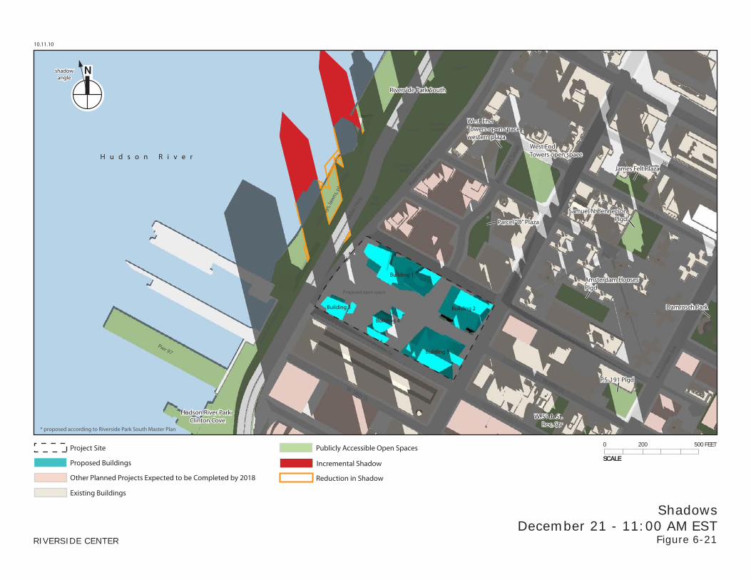
ShadowsDecember 21 - 11:00 AM EST
Figure 6-21
shadowangle
Publicly Accessible Open Spaces
Proposed Buildings
Other Planned Projects Expected to be Completed by 2018
Project Site
Existing Buildings
Reduction in Shadow
Incremental ShadowSCALE
0 200 500 FEET
Mill
er H
wy.
Free
dom
Pl. S
outh
Riversi
de Blvd
.
Wes
t End
Ave
.
Amst
erda
m A
ve.
W. 65th St.
W. 61st St.Pier 97
W. 64th St.
W. 60th St.
W. 59th St.
W. 58th St.
H u d s o n R i v e r
Damrosch Park
Riverside Park South
James Felt Plaza
Amsterdam HousesPlgd
Samuel N. BennersonPlgd
P.S. 191 Plgd
W. 59th St.Rec. Ctr
Hudson River Park -Clinton Cove
Building 1
Building 2Building 3
Building 4
Building 5
TotPlay*
ClimbingWall*
Amphi-theater*Lawn*
Lawn*
Wal
kway
s, la
wns
, pla
ntin
gs
* proposed according to Riverside Park South Master Plan
Proposed open space
Rout
e 9A
Bik
eway
West EndTowers open space
Parcel “O” Plaza
West EndTowers open space -western plaza
10.11.10
RIVERSIDE CENTER
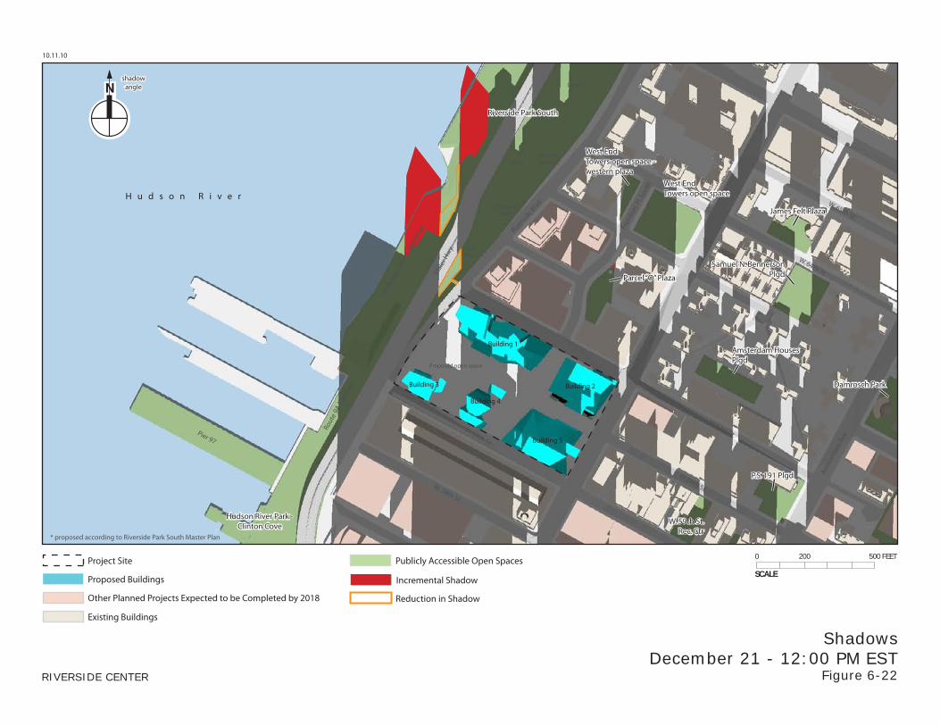
ShadowsDecember 21 - 12:00 PM EST
Figure 6-22
shadowangle
Publicly Accessible Open Spaces
Proposed Buildings
Other Planned Projects Expected to be Completed by 2018
Project Site
Existing Buildings
Reduction in Shadow
Incremental ShadowSCALE
0 200 500 FEET
Mill
er H
wy.
Free
dom
Pl. S
outh
Riversi
de Blvd
.
Wes
t End
Ave
.
Amst
erda
m A
ve.
W. 65th St.
W. 61st St.Pier 97
W. 64th St.
W. 60th St.
W. 59th St.
W. 58th St.
H u d s o n R i v e r
Damrosch Park
Riverside Park South
James Felt Plaza
Amsterdam HousesPlgd
Samuel N. BennersonPlgd
P.S. 191 Plgd
W. 59th St.Rec. Ctr
Hudson River Park -Clinton Cove
Building 1
Building 2Building 3
Building 4
Building 5
TotPlay*
ClimbingWall*
Amphi-theater*Lawn*
Lawn*
Wal
kway
s, la
wns
, pla
ntin
gs
* proposed according to Riverside Park South Master Plan
Proposed open space
Rout
e 9A
Bik
eway
West EndTowers open space
Parcel “O” Plaza
West EndTowers open space -western plaza
10.11.10
RIVERSIDE CENTER
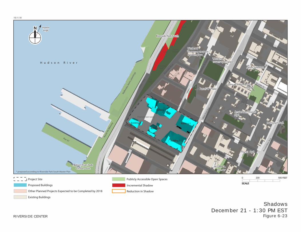
ShadowsDecember 21 - 1:30 PM EST
Figure 6-23
shadowangle
Publicly Accessible Open Spaces
Proposed Buildings
Other Planned Projects Expected to be Completed by 2018
Project Site
Existing Buildings
Reduction in Shadow
Incremental ShadowSCALE
0 200 500 FEET
Mill
er H
wy.
Free
dom
Pl. S
outh
Riversi
de Blvd
.
Wes
t End
Ave
.
Amst
erda
m A
ve.
W. 65th St.
W. 61st St.Pier 97
W. 64th St.
W. 60th St.
W. 59th St.
W. 58th St.
H u d s o n R i v e r
Damrosch Park
Riverside Park South
James Felt Plaza
Amsterdam HousesPlgd
Samuel N. BennersonPlgd
P.S. 191 Plgd
W. 59th St.Rec. Ctr
Hudson River Park -Clinton Cove
Building 1
Building 2Building 3
Building 4
Building 5
TotPlay*
ClimbingWall*
Amphi-theater*Lawn*
Lawn*
Wal
kway
s, la
wns
, pla
ntin
gs
* proposed according to Riverside Park South Master Plan
Proposed open space
Rout
e 9A
Bik
eway
West EndTowers open space
Parcel “O” Plaza
West EndTowers open space -western plaza
10.11.10
RIVERSIDE CENTER
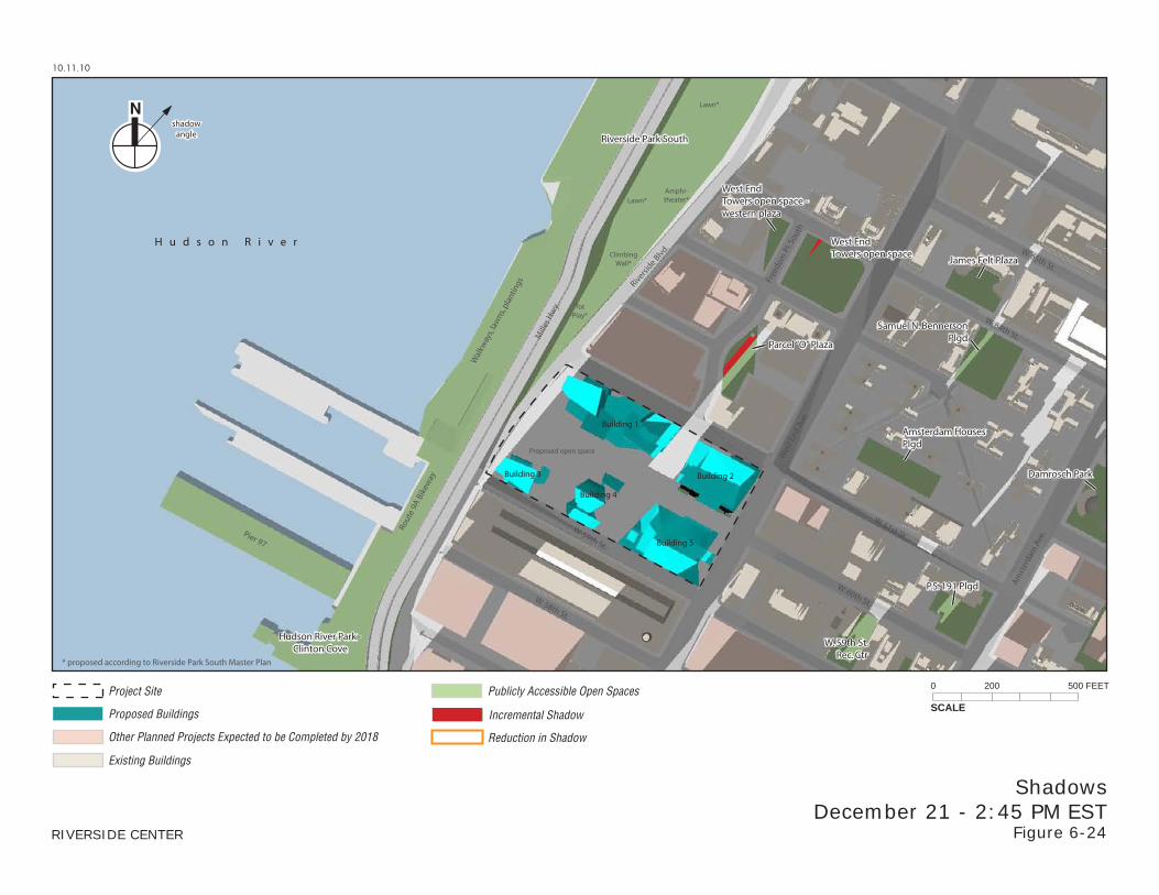
ShadowsDecember 21 - 2:45 PM EST
Figure 6-24
shadowangle
Publicly Accessible Open Spaces
Proposed Buildings
Other Planned Projects Expected to be Completed by 2018
Project Site
Existing Buildings
Reduction in Shadow
Incremental ShadowSCALE
0 200 500 FEET
Chapter 6: Shadows
6-5
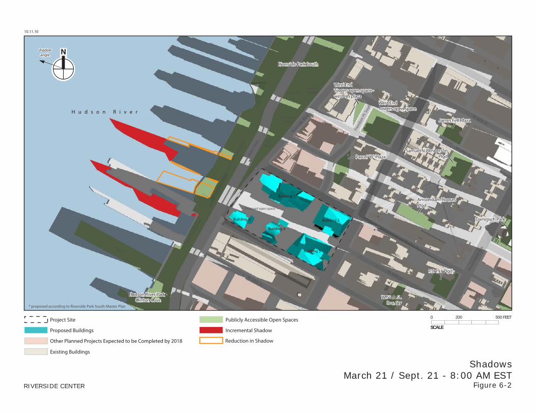
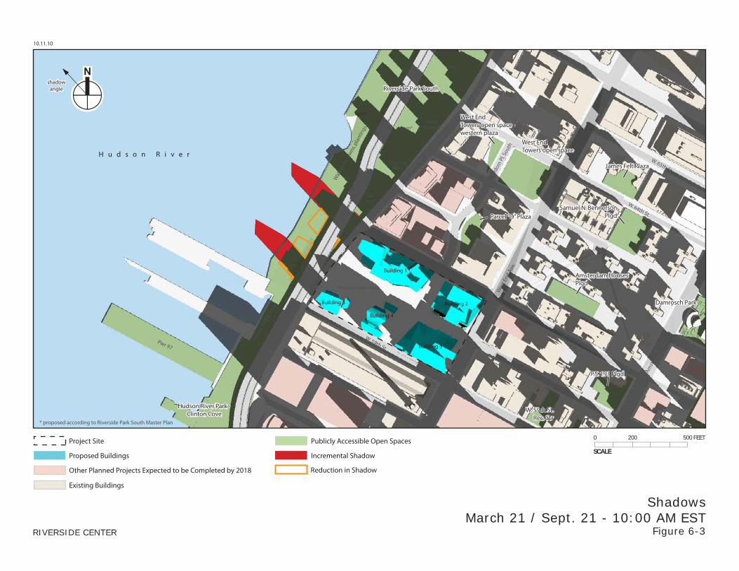
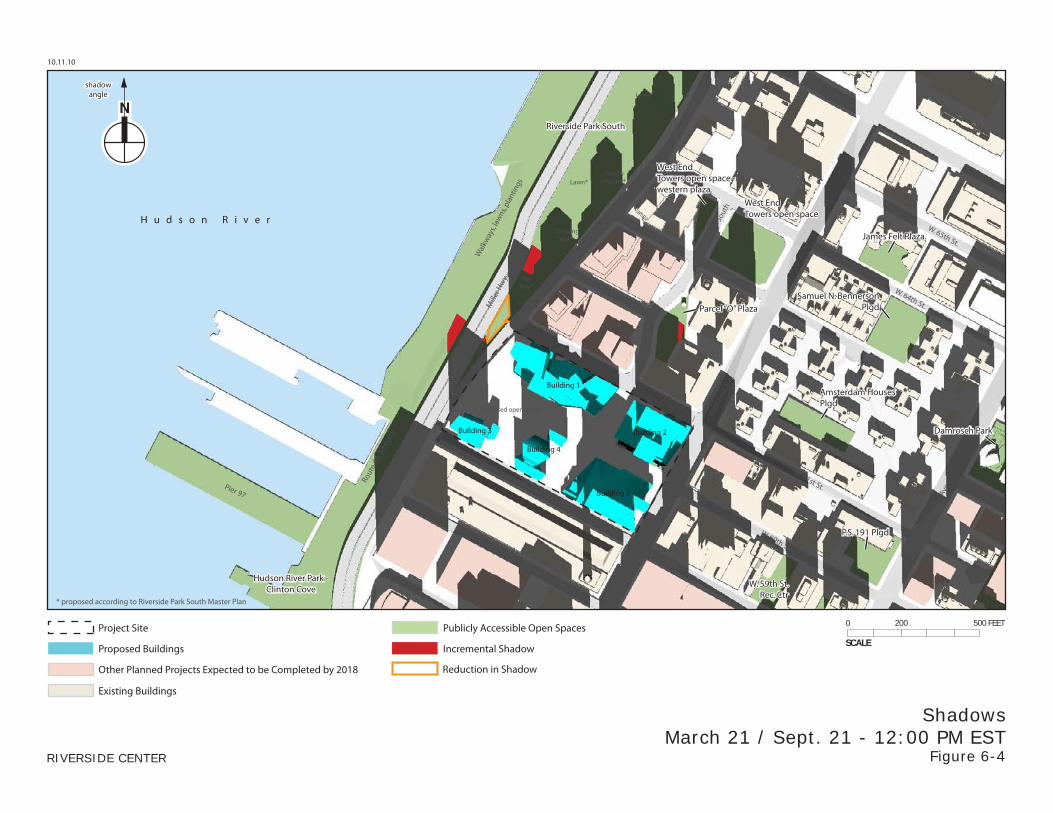
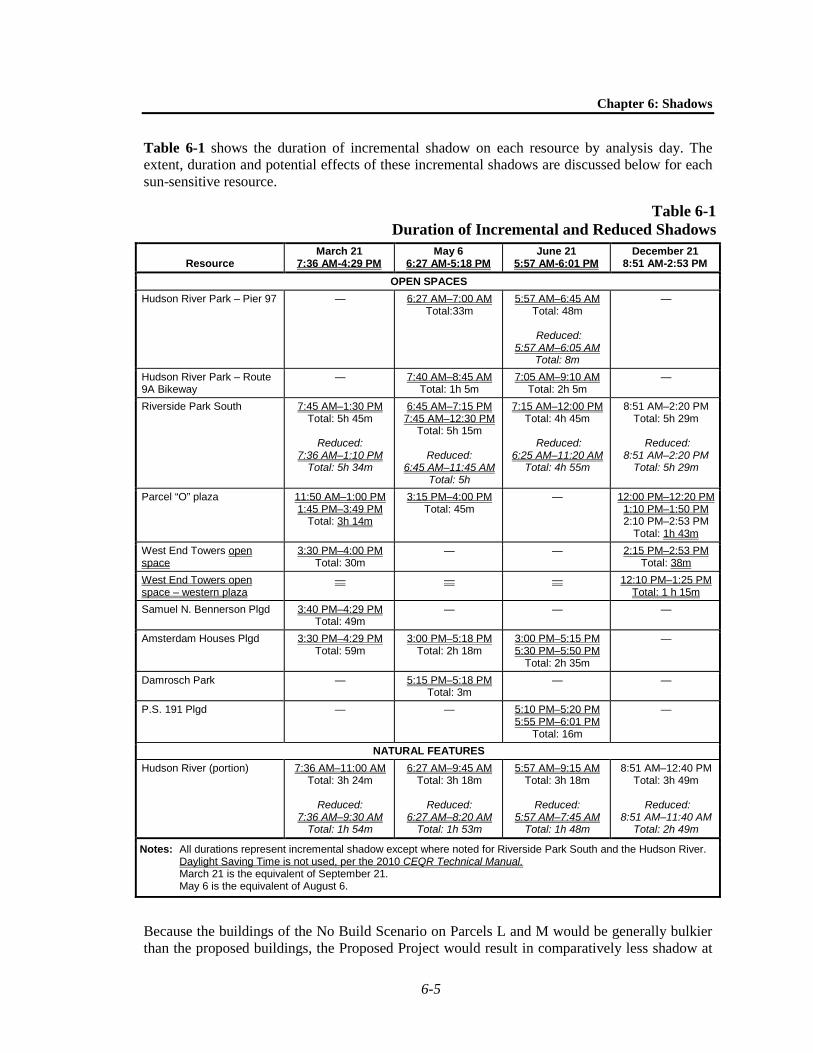
Table 6-1 shows the duration of incremental shadow on each resource by analysis day. The extent, duration and potential effects of these incremental shadows are discussed below for each sun-sensitive resource.
Table 6-1 Duration of Incremental and Reduced Shadows
Resource March 21
7:36 AM-4:29 PM May 6
6:27 AM-5:18 PM June 21
5:57 AM-6:01 PM December 21
8:51 AM-2:53 PM OPEN SPACES
Hudson River Park – Pier 97 — 6:27 AM–7:00 AM Total:33m
5:57 AM–6:45 AM Total: 48m
Reduced:
5:57 AM–6:05 AM Total: 8m
—
Hudson River Park – Route 9A Bikeway
— 7:40 AM–8:45 AM Total: 1h 5m
7:05 AM–9:10 AM Total: 2h 5m
—
Riverside Park South 7:45 AM–1:30 PM Total: 5h 45m
Reduced:
7:36 AM–1:10 PM Total: 5h 34m
6:45 AM–7:15 PM 7:45 AM–12:30 PM
Total: 5h 15m
Reduced: 6:45 AM–11:45 AM
Total: 5h
7:15 AM–12:00 PM Total: 4h 45m
Reduced:
6:25 AM–11:20 AM Total: 4h 55m
8:51 AM–2:20 PM Total: 5h 29m
Reduced:
8:51 AM–2:20 PM Total: 5h 29m
Parcel “O” plaza 11:50 AM–1:00 PM 1:45 PM–3:49 PM
Total: 3h 14m
3:15 PM–4:00 PM Total: 45m
— 12:00 PM–12:20 PM 1:10 PM–1:50 PM 2:10 PM–2:53 PM
Total: 1h 43m West End Towers open space
3:30 PM–4:00 PM Total: 30m
— — 2:15 PM–2:53 PM Total: 38m
West End Towers open space – western plaza
— — — 12:10 PM–1:25 PM Total: 1 h 15m
Samuel N. Bennerson Plgd 3:40 PM–4:29 PM Total: 49m
— — —
Amsterdam Houses Plgd 3:30 PM–4:29 PM Total: 59m
3:00 PM–5:18 PM Total: 2h 18m
3:00 PM–5:15 PM 5:30 PM–5:50 PM
Total: 2h 35m
—
Damrosch Park — 5:15 PM–5:18 PM Total: 3m
— —
P.S. 191 Plgd — — 5:10 PM–5:20 PM 5:55 PM–6:01 PM
Total: 16m
—
NATURAL FEATURES Hudson River (portion) 7:36 AM–11:00 AM
Total: 3h 24m
Reduced: 7:36 AM–9:30 AM
Total: 1h 54m
6:27 AM–9:45 AM Total: 3h 18m
Reduced:
6:27 AM–8:20 AM Total: 1h 53m
5:57 AM–9:15 AM Total: 3h 18m
Reduced:
5:57 AM–7:45 AM Total: 1h 48m
8:51 AM–12:40 PM Total: 3h 49m
Reduced:
8:51 AM–11:40 AM Total: 2h 49m
Notes: All durations represent incremental shadow except where noted for Riverside Park South and the Hudson River. Daylight Saving Time is not used, per the 2010 CEQR Technical Manual.
March 21 is the equivalent of September 21. May 6 is the equivalent of August 6.
Because the buildings of the No Build Scenario on Parcels L and M would be generally bulkier than the proposed buildings, the Proposed Project would result in comparatively less shadow at
Riverside Center FSEIS
6-6
times on adjacent areas of Riverside Park South and the Hudson River. At the same time, the proposed buildings would be taller than the No Build Scenario buildings, resulting in areas of incremental shadow. Table 6-1 shows both incremental and reduced shadow durations on Riverside Park South. While the durations of incremental and reduced shadow on Riverside Park South would be similar, the areas of reduced shadow would be larger than the areas of incremental shadow for most of the total durations. See Figures 6-2 through 6-4, which show March 21 / September 21 mornings. This is due to the fact that the lower portions of the No Build Scenario buildings would be bulkier than those of the Proposed Project buildings. Further away from the project, on the Hudson River, the comparatively taller buildings of the Proposed Project would create larger areas of incremental shadow than reduced shadow. No other resources experienced a reduction in shadow with the Proposed Project.
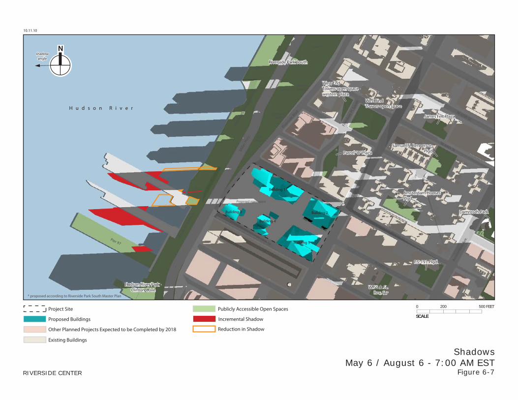
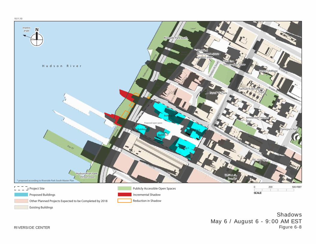
HUDSON RIVER PARK
PIER 97
Pier 97 is currently used for New York City Department of Sanitation (DSNY) truck parking. This agency is in the process of building a new garage for the trucks currently stored on this pier; once it is complete, the trucks will be relocated. According to the Hudson River Park Trust, in the future Pier 97 will be rebuilt as a public pier and incorporated within the Clinton Cove section of the park. Amenities on Pier 97 will include courts for active recreation, a playground and a lawn. Pier 97 will also be used to berth historic ships. It is unknown at this time when the conversion is expected to be completed, so this analysis conservatively includes it as an open space. No other part of Hudson River Park would be affected by project-generated shadow.
Pier 97 would experience between 33 and 48 minutes of incremental shadow early in late spring and summer mornings. Situated as it is on the Hudson River, it would continue to get direct sunlight throughout the late morning and afternoon. No incremental shadow would occur in the fall, winter or early spring. The limited extent and duration of project shadow would therefore not cause a significant adverse impact to this space.
ROUTE 9A BIKEWAY
A portion of the Route 9A Bikeway would receive between one and two hours of incremental shadow on late spring and summer mornings. This portion of the bikeway is solely an active recreation resource, and its users would not be significantly impacted by the new shadows from the Proposed Project. The bikeway would continue to experience a great deal of direct sunlight throughout the early, middle and late afternoons of the spring, summer and fall, due to the open vistas above the river to their west, and therefore there would not be a significant adverse impact on the health of the strip of landscaping along the bikeway.
RIVERSIDE PARK SOUTH
Certain areas of this park are still being developed. The completed park will stretch along the waterfront between West 72nd Street, where it connects to Riverside Park, down to West 59th Street, where it connects to Hudson River Park. It will also include an upland portion on the east side of the raised Miller highway. The esplanade and waterfront portions are complete along the entire length of the park, and include coastal plantings, boardwalks, terraces, a pier extending into the river at West 70th Street, passive seating areas, a continuation of the waterfront bike bath, a restored cove area at shade structures, a river step-down, lawn mounds, a boat landing
Chapter 6: Shadows
6-7
and an antique 95-ton locomotive engine. The upland portion between the Miller highway and Riverside Boulevard is currently under development, with only the children’s play area at West 67th Street completed at this time.
The Proposed Project would cast areas of incremental shadow on the park from morning through early afternoon in all seasons. However, in comparison with the No Build Scenario, the slimmer buildings of the Proposed Project would also cast less shadow on certain areas of the park. Overall, total durations of incremental and reduced shadow on Riverside Park South are nearly the same, and more often than not, the areas of reduced shadow are larger than the areas of incremental shadow, as can be seen in the figures showing morning and early afternoon times on all four analysis days.
In the mornings of the spring, summer and fall, the areas of incremental and reduced shadow would fall primarily on the landscaped walkways and plantings west and northwest of the project site, on the west side of the Miller highway. At mid-day, incremental and reduced shadow would fall mostly on the areas northwest and north of the project site between the Miller highway and Riverside Boulevard, where ball courts, a skateboard park and playground areas will be located. Additional incremental shadow from the tops of the proposed buildings would fall on the west side of the Miller highway at this time (having moved eastward from the Hudson River where it had fallen earlier in the morning), on the area of walkways and plantings (see for example Figure 6-4 showing March 21/September 21 at 12:00 PM or Figure 6-9 showing May 6/August 6 at 11:00 AM).
In general, at any given time the areas that would be affected by incremental shadow and by reduced shadow are adjacent to each other, and are characterized by the same types of uses and features. For example, in the spring, summer and fall mornings when one portion of the walkways and landscaping west of the project site and the Miller highway would experience incremental shadow, adjacent portions of this area would be in reduced shadow with the Proposed Project (see Figures 6-3, 6-8 and 6-14). Similarly, in the late morning or early afternoon when incremental shadow would fall on the active recreation amenities on the east side of the Miller highway such as the ball courts or skateboard area, reduced shadow would also occur there with the Proposed Project (see Figures 6-4 and 6-9).
On the December 21 analysis day, incremental and reduced shadow would fall further to the northwest and north, and the active recreation areas within Riverside Park South adjacent to the project site and the buildings on parcels J1/J2 and K1/K2 would be in existing shadow for virtually the entire day. Areas of reduced shadow from the Proposed Project would fall on the landscaping and walkways on the west side of the Miller highway in the late morning, and areas of incremental shadow would fall on lawns, walkways and landscaping in the middle of the day.
Most of the park would be in sun by early afternoon and all areas of the park would continue to experience direct sun through the middle and late afternoons in the spring, summer and fall. Given the limited net incremental shadow in the mornings, and the ample sun in the afternoons, the Proposed Project would not cause a significant adverse impact to Riverside Park South.
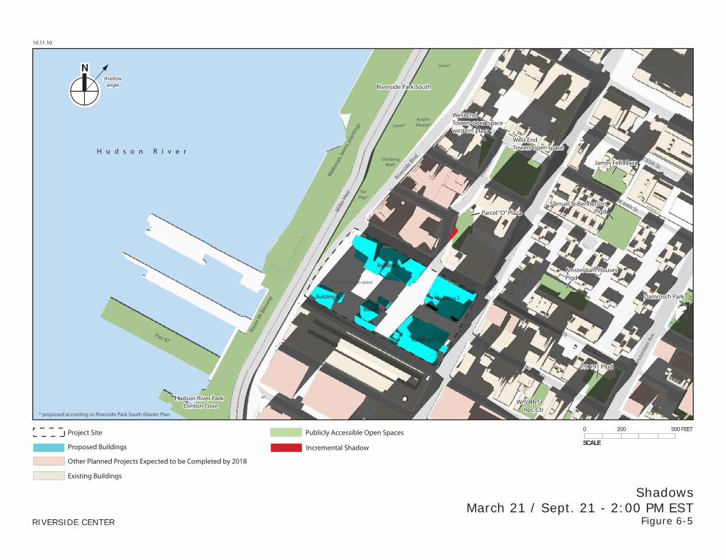
PARCEL “O” PLAZA
This plaza is a newly developed, publicly accessible open space at Freedom Place South and West 62nd Street. Most of the southwestern half of the space is hard-surfaced plaza, with some planted areas, and most of the northeastern half is grass, trees and plantings.
Riverside Center FSEIS
6-8
On March 21 and September 21, Building 2 would cast a small area of incremental shadow on this open space between 11:50 AM and 1:00 PM, primarily on the northeastern section (see Figure 6-4). Later in the afternoon, from 1:45 PM to 3:49 PM, Building 1 would also cast a small shadow on the plaza, mainly on the paved southwestern section (see Figure 6-5). The buildings on Site K2 and Site O would stand directly between the proposed Buildings 1 and 2 and the Parcel O Plaza, and would already cast shadows that would eliminate most of the new shadows from the Proposed Project (see Figures 6-4 and 6-5). However, all remaining direct sunlight would be eliminated by incremental shadows cast by the Proposed Project on the Parcel O Plaza for approximately 17 minutes (3:33 PM to 3:49 PM). The area of remaining sunlight that would be eliminated would be very small, about 2 percent of the total area of the plaza at its greatest extent. The affected area is located in the north corner of the space behind a large ventilation or mechanical structure in a section that is densely landscaped with shrubs and plantings. The affected area is essentially inaccessible to anyone using the open space, and the view of that area from accessible portions of the open space is substantially obstructed. There are no benches or other facilities for passive recreation in the area of incremental effect. In addition, the plant species located in the area that would be affected by the incremental shadow during the relevant analysis period thrive in both sun and shade. Because these species are generally shade tolerant, the incremental shadow would not be expected to adversely affect their growth and/or continued propogation.
On the May 6 and August 6 analysis day, Building 2’s shadow would not be long enough to reach the Parcel O Plaza, and Building 1 would cast a small incremental shadow on the plaza from 3:15 PM to 4:00 PM. No new shadow from the Proposed Project would reach the plaza on June 21.
On December 21, incremental shadow would fall on portions of the open space for a total of about an hour and 45 minutes during the period between noon and the end of the analysis day at 2:53 PM (see Figures 6-22 to 6-24). All remaining direct sunlight would be eliminated on the Parcel O Plaza for approximately 20 minutes (12:00 PM to 12:20 PM). However, the area of sunlight that would be eliminated at this time would be very small, approximately 1 percent of the total area of the plaza at its greatest extent (see Figure 6-22). Further, the affected area would be approximately the same area similarly affected on the December 21 analysis day, in the northern corner behind a large mechanical structure surrounded by dense shrubbery and other plantings which impede accessibility. The rest of the plaza would be in existing shadow at this time. A small area of incremental shadow would also occur on the plaza between 1:10 PM and 1:50 PM (see Figure 6-23) and between 2:10 PM and 2:53 PM (see Figure 6-24). Some sunlight would continue to reach the plaza at these times. The new shadow would not have a material effect on vegetation during the winter. Nor would the extent and duration of incremental shadow be large or long enough to significantly impact users of the park in the winter.
In the spring, summer and fall, the limited extent of project-generated shadow would not cause a significant adverse impact to the plaza. While incremental shadow from the Proposed Project would eliminate all remaining sunlight from the Parcel O Plaza for 20 minutes on the December 21 analysis day and 17 minutes on the March 21/ September 21 analysis day, it would not be considered a significant adverse shadow impact. The area where remaining sunlight would be affected is approximately 2 percent of the total park area at its maximum extent, and on both analysis days the affected area is in the northern corner, behind a mechanical structure surrounded by dense plantings which impedes access and obstructs visibility. In addition, the plant species located in the area that would be affected by the incremental shadow during the
Chapter 6: Shadows
6-9
relevant analysis period thrive in both sun and shade. Because these species are generally shade tolerant, the incremental shadow would not be expected to adversely affect their growth and/or continued propagation.
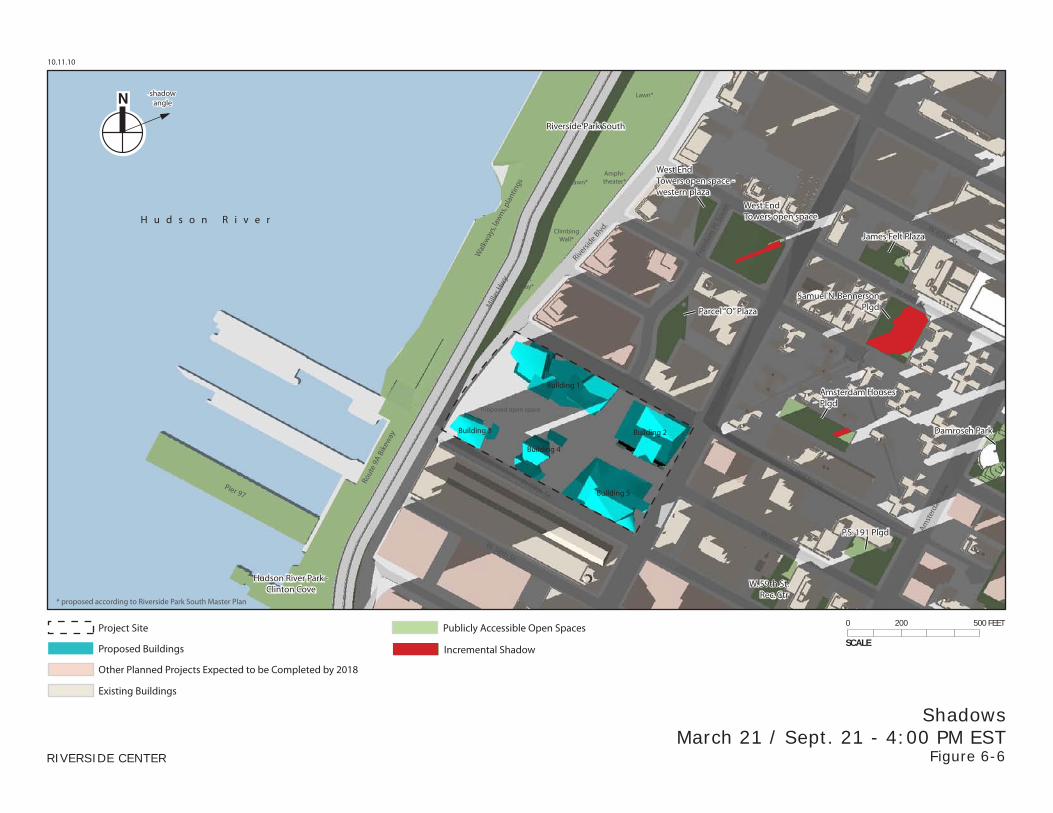
WEST END TOWERS OPEN SPACE
This park is located three blocks north of the project site. It would experience 30 minutes of incremental shadow near the end of the March 21/September 21 analysis day, and 38 minutes of incremental shadow at the end of the December 21 analysis day. For 25 minutes of the December 21 analysis day, between 2:28 PM and the end of the analysis day at 2:53 PM, all remaining direct sunlight would be eliminated by incremental shadow cast by the Proposed Project. During the first 10 minutes of this 25-minute period, approximately 80 percent of the open space would already be in shadow from existing buildings, with approximately 20 percent of the open space in incremental shadow, located along its western border. In the next 10 minutes, the area of incremental shadow would get smaller (10 percent of the open space; see Figure 6-24) and in the final 5 minutes of the 25-minute period, the area of incremental shadow would be even smaller (5 percent).
As mentioned above, the affected area is along the western border of the block. The majority of the area of remaining sunlight that would be affected by the incremental shadow from the Proposed Project includes a portion of a lawn area with pockets of densely planted trees and shrubs, and portions of two paths to the north and south of the lawn area that each contains one or two benches. There are no benches within the landscaped lawn area. With each successive 10 minute segment during the 25-minute period, a smaller portion of the lawn area and these paths would be affected by incremental shadow from the Proposed Project (i.e., the area of remaining sunlight that would be eliminated would get progressively smaller through the first two 10-minute segments and the final 5-minute segment of the 25-minute period in question).
It is unlikely that the West End Towers open space would be well-used for passive recreational activities during the winter due to the cold weather. Although site visits were not conducted during the winter analysis period, a site visit on August 3, 2010 found that the benches along the paths on the western side of the space were not occupied, while the playground area and seating on the eastern side of the space were heavily used. Furthermore, while the remaining sunlight would be eliminated for 25 minutes from the West End Towers open space, other interrelated neighborhood open spaces within two blocks of this open space (forming a functionally interrelated network of public open spaces associated with several large developments including Riverside South, the West End Towers, and the Proposed Project)—in particular, the Parcel O Plaza one block to the south, Riverside Park South to the west, and the Proposed Project’s open space two blocks to the south—would offer comparable seating opportunities in sunlit areas during the period of time when sunlight would be eliminated in the affected area of the West End Towers open space as a result of the Proposed Project (see Figure 6-24). In addition, the seating areas within the West End Towers open space would experience sunlight for most of the analysis day (between 9:15 AM and 1:00 PM). Also, the plant species located in the area that would be affected by the incremental shadow during the relevant analysis period thrive in both sun and shade. Because the plant species are generally shade tolerant, the incremental shadow would not be expected to adversely affect their growth and/or continued propagation. For all these reasons, the elimination of the sunlight from this area of West End Towers open space for the 25-minute period during this December 21 analysis day would not be considered a significant adverse shadows impact.
Riverside Center FSEIS
6-10
The West End Towers open space would not experience any incremental shadow on the late spring and summer analysis days, and the limited duration of project shadow on March 21/September 21 and December 21 would not cause a significant adverse impact.
WEST END TOWERS OPEN SPACE – WESTERN PLAZA
This publicly accessible open space, completed in June 2009, forms part of the rear plaza associated with the apartment building adjacent on its western side (the Rushmore). It is paved and contains large ivy-filled planters with ledges, and no other amenities.
On the December 21 analysis day, incremental shadow would fall on this plaza between 12:10 PM and 1:25 PM, During this period, the incremental shadow would remove the remaining sunlight from this space between 12:10 PM and 1:00 PM.
This space has no benches or other passive recreational amenities. During a site visit on August 17, 2010, no users were present in the plaza. By contrast, the playground area and seating on the eastern side of the main West End Towers open space to the east were heavily utilized. It is likely that in the cold months represented by the December 21 analysis day, the plaza would be similarly unused. In addition, during the period from 12:10 PM to 1:00 PM, other neighborhood open spaces (forming a functionally interrelated network of public open spaces associated with the Riverside South development, the West End Towers development, and the Proposed Project), within three blocks of this open space—the main West End Towers open space to the east, Riverside Park South to the west, and the Proposed Project’s open space three blocks to the south—would offer seating opportunities in sunlit areas during this limited period of time. Additionally, since the incremental shadow would not occur during the growing season, the vegetation would not be adversely affected. Therefore, the incremental shadow occurring on the December 21 analysis day would not be considered a significant adverse shadows impact.
SAMUEL N. BENNERSON PLAYGROUND
This playground is located on the south side of West 64th Street between Amsterdam and West End Avenues. It would experience about 50 minutes of incremental shadow at the end of the March 21/September 21 analysis day, from 3:40 PM to 4:29 PM. On December 21 project shadow would not reach far enough east to fall on the playground, and in the late spring and summer project shadow would not be long enough to reach the playground. The limited duration of incremental shadow would not cause a significant adverse impact.
AMSTERDAM HOUSES PLAYGROUND
The Amsterdam Houses contain a section of playground, located midblock just south of the line of West 62nd Street. This open space contains play equipment flanked by groups of benches on the west and east sides.
The space, located a block east of the project site, would experience incremental shadow in the late afternoons of the spring, summer and fall. An intervening apartment building, part of the New York City Housing Authority (NYCHA)-run complex, already cast some shadow on the space at this time of day and effectively blocks some project-generated shadow. Additionally, a 33-story building projected to be built by 2018 at the southeast corner of West 61st Street and West End Avenue would also block a substantial amount of project shadow on the March 21/September 21 analysis day, though not on the other analysis days. The playground and adjacent benches would experience an hour of project shadow in the fall and early spring, and
Chapter 6: Shadows
6-11
two and a half hours in the late spring and summer. In March and September, the extent of incremental shadow would be small during the one hour period (see Figure 6-6), and the space would continue to get ample sun throughout the morning midday and afternoon (see Figures 6-2 to 6-5). In the late spring and summer, areas of incremental shadow would be more substantial. On May 6 and August 6 project-generated shadow would fall on the space for a total of about two hours and twenty minutes (see Figures 6-11 and 6-12), and would cover half the space or more for over an hour. On June 21 shadows are shorter and project-generated shadow would only momentarily cover half the space, around 4:30 PM, but would cover at least a third of the space for about an hour (3:45 PM to 4:45 PM; see Figure 6-18). However, even during the two and a half hours of incremental shadow in the late spring and summer, portions of the playground and benched areas would continue to be in sun, and through the morning, early and mid-afternoon this open space would be mostly or fully in sun, as can be seen in the corresponding figures. The trees and other vegetation of the space would continue to receive enough sun, and the incremental shadow would not be substantial enough to significantly impact users of the playground and adjacent seating areas.
DAMROSCH PARK
This park on the northeast corner of Amsterdam Avenue and West 62nd Street would experience about three minutes of incremental shadow at the very end of the May 6/August 6 analysis day. Project shadow would not reach it on the other three analysis days, and this limited duration would not cause a significant adverse impact.
P.S. 191 PLAYGROUND
This paved school playground, located on the northwest corner of Amsterdam Avenue and West 60th Street, is generally not open to the public. It would experience about 15 minutes of incremental shadow at the end of the June 21 analysis day. It is located too far south of the project site to be affected by incremental shadow on the other analysis days. The limited duration of new shadow would not cause a significant adverse impact.
HUDSON RIVER
The Proposed Project would cast new shadows on portions of the Hudson River throughout the morning in all seasons, and would also result in less shadows on some areas of the river in comparison with the No-Build Scenario (see Figures 6-2, 6-3, 6-6, 6-7, 6-13, 6-14, 6-20, and 6-21). The areas affected by incremental shadow would primarily be adjacent to the shoreline, often amongst Piers 97, 98, and 99 west of the project site. While the total duration of new shadow ranges between three and three and a half hours for most of the year, most affected areas of the river would receive shorter durations as the shadows move eastward and northward during the morning. The areas that would receive the longest durations of new shadows on summer mornings would continue to receive more than six hours of sunlight in the afternoon, because there are no intervening structures to the west.
The shoreline areas that would be affected by incremental shadow are completely bordered by hard surfaces, including a concrete bulkhead and boat launch, riprap, and large stone armoring. A portion of shoreline within the small cove area west of the hard shoreline is exposed during low tide. The substrate of this intertidal area comprises cobble, brick and stone from historic in-water uses and does not support tidal wetlands plants, macrophytic algae, or submerged aquatic vegetation. In addition, the current flows swiftly in the Hudson River and
Riverside Center FSEIS
6-12
would move phytoplankton and other natural elements quickly through the shaded areas. Therefore, incremental shadows generated by the Proposed Project would not have a significant adverse impact on primary productivity within the Hudson River.
PROPOSED RIVERSIDE CENTER OPEN SPACE
As discussed above, according to CEQR methodology, shadows cast on open spaces that are part of a proposed project are not considered impacts of an action because, without the action, the open space would not exist. However, the following discussion provides a qualitative discussion of shadows on the proposed open space.
The Proposed Project would create a total of 2.75 acres of new privately owned, publicly accessible open space on the project site. It is anticipated that its features would include landscaped and plaza areas. The availability and duration of sunlight that this open space would experience was considered in its design, and will be taken into account in the selection of appropriate plantings. Connections would be made throughout the open space to adjacent streets and to Riverside Park South.
As the figures show, the project’s proposed open spaces would experience a mix of sun and shade throughout the day in the fall, winter and early spring. In the spring and fall, the central area of the main open space would experience sun from the east in the mornings (see Figure 6-2). By late morning most of the open spaces would be shaded by Buildings 3, 4 and 5, though one section of the space (just south of Building 1) would still be in sun (see Figure 6-3). By mid-day sunlight from the south would fall between Buildings 3 and 4 onto an area in the middle of the central open space, while the rest of the spaces would be mostly in shade (see Figure 6-4). Later in the afternoon, the western portion of the open spaces facing the waterfront would be in sunlight coming from the west (see Figures 6-5 and 6-6). On December 21, the open spaces would be completely in shadow in the morning (see Figure 6-20), but in the late morning and afternoon they would experience a small area of sun (see Figures 6-21, 6-22 and 6-23). On the May 6 and August 6 analysis days the space would be in substantial shade in the morning around 7:00 AM (see Figure 6-7) and in the early afternoon from Buildings 3 and 4 (see Figure 6-10) but would experience large areas of sun in the late morning (see Figures 6-8 and 6-9) and late afternoon (see Figures 6-11 and 6-12). On June 21 when shadows are shortest, the open spaces would be in shadow from 6:00 AM to 8:00 AM (see Figures 6-13 and 6-14), but would be mostly in sun from late morning until the end of the day (see Figures 6-15 through 6-19).
F. FUTURE CONDITION WITH THE MILLER HIGHWAY RELOCATION
As described in Chapter 1, “Project Description,” for certain environmental issues—including shadows—the 1992 FEIS analyzed an additional scenario in which the elevated portion of the Miller Highway (also known as Route 9A) between 59th Street and 72nd Street would be relocated to an inboard, below-grade location by 2002, the anticipated completion year for the Riverside South project.
At this time the Miller Highway has not been relocated, and there is no funding allocated toward advancing the project. However, since the highway may, in the future, be relocated, , this section considers an additional future condition in which the highway relocation takes place by the Proposed Project’s Build year of 2018, in a manner similar to that described in the 1992 FEIS,
Chapter 6: Shadows
6-13
and as analyzed in greater detail as part of the Preferred Alternative scenario in the October 2000 Miller Highway Project FEIS.
In this condition, the Miller Highway would be relocated inboard under and next to Riverside Drive, from 72nd Street down to 61st Street, where it would emerge from the tunnel. From 61st to 59th Street it would be uncovered.
In relation to the proposed project and its shadows, the primary effect of the Miller Highway Relocation would be to reduce the area of parkland immediately west of the project site. This would occur because the Miller Highway would emerge from its tunnel and widen as it approaches 59th Street, and also because Riverside Drive would split above the tunnel mouth at West 61st Street into two roadways, running on either side of the emerging Miller Highway. Less parkland and more roadway area would mean smaller areas of both incremental and reduced shadow, in comparison to the condition analyzed above, without the Miller Highway Relocation.
The other effect of the Relocation would be to reduce baseline shadows on Riverside Park South north of West 61st Street, because the shadows that had been cast under and next to the raised highway would be removed. Therefore, in the late mornings when project shadow would fall to the northwest, there would be slightly larger areas of both incremental and reduced shadow, in comparison with the No Build Scenario, than there would in the condition without the Miller Highway Relocation.
These small increases and decreases in incremental and reduced shadow would not affect the shadows analysis for any feature anlayzed above, and therefore would not change the conclusion that the Proposed Project would not cause any significant adverse shadow impacts. (See Appendix B for a comparison of the incremental and reduced shadows due to the relocation of the highway).