Embed Size (px)
Citation preview
Chapter 5: Ecosystems and Hydrology___________________________________________________________________________

Chapter 5: Ecosystems and Hydrology 102
INTRODUCTION
The prioritization model developed for this project utilizes ecological criteria to select keyland areas for conservation. The three goals of the project (conserve areas of high ecologicalimportance, promote spatial integrity of the landscape, and identify and delineate threats toecological systems and processes) relate directly to protecting the mosaic of landscapeecosystems that are found within the study area. The purpose of this section of the report isto provide ecological context by describing the conceptual framework that underlies theproject and by providing basic descriptions of the various ecosystems and hydrology of theproject study area.
CONCEPTUAL FRAMEWORK
Like J.S. Rowe (1961), the project team defines a landscape ecosystem as “…a topographicunit, a volume of land and air plus organic contents extended over a particular part of theEarth’s surface for a certain time.” In other words, the team views ecosystems as holisticchunks of Earth space – topographic features made up of distinct physiography (the surfacefeatures of an area plus the geological parent material below its surface), climate, soils, andbiota. These days, there are nearly as many definitions for the term ecosystem as there areecologists. Many ecologists view ecosystems primarily as the places where organisms live,or as organisms plus their abiotic environment. Definitions of this sort are focused onorganisms; more specifically they focus on their component populations or broadercommunities. By contrast, the definition to which the project team subscribes focuses onlandscape or geographic units with organisms as only one of several integral parts.
A broad landscape, or even the entire planet, can be conceived as a series of ecosystems,large and small, nested within one another in a hierarchy of spatial sizes (Barnes et al., 1998).Therefore, one can identify ecosystems at multiple spatial scales depending on the ecosystemcomponent-scale of interest (ecosystem components being climate, physiography, soils, andbiota). For instance, delineating ecosystems based on differences in macroclimate and largegeologic features will lead to the identification of large, regional ecosystems, perhaps in the1,000 to 100,000 acre range. However, delineating ecosystems based on differences inmicroclimate, soils, vegetative cover, and local landforms (i.e., topographic features such asmountain slopes, hills, and depressions) will lead to the identification of smaller, localecosystems, ranging from roughly 100 to 1,000 acres in size.
Regardless of scale, landscape ecosystems are natural organizing units for land management,preservation, and restoration because they are definable, mappable topographic units. Forexample, in the German state of Baden-Württemberg, ecosystem mapping has been a majorfactor in forest management efforts for over 50 years (Barnes, 1984). Forest managers inBaden-Württemberg developed an ecosystem mapping process consisting of two primarystages. The first stage is regionalization, where ecosystem boundaries are determined basedon differences in physiography, climate, soils, and biota across a given landscape. The
Chapter 5: Ecosystems and Hydrology 103
second stage is classification, where the most similar ecosystems are lumped into variousecosystem types. Similar methods have been used to describe and map ecosystems withinportions of the United States (Tepley, 2001; Syring, 2000; Albert, 1995; Spies, 1985). Thesemapping efforts are multi-scaled in that ecosystems are identified at a variety of spatial scalesand are multi-factored in that the ecosystem components of physiography, climate, soils, andbiota are all used in determining ecosystem boundaries and types. In this project, the teamuses the regional ecosystem map of Michigan originally produced by Albert, Denton, andBarnes in 1986 (and expanded by Albert in 1995 to include Minnesota and Wisconsin) as aprimary ecological organizing tool.
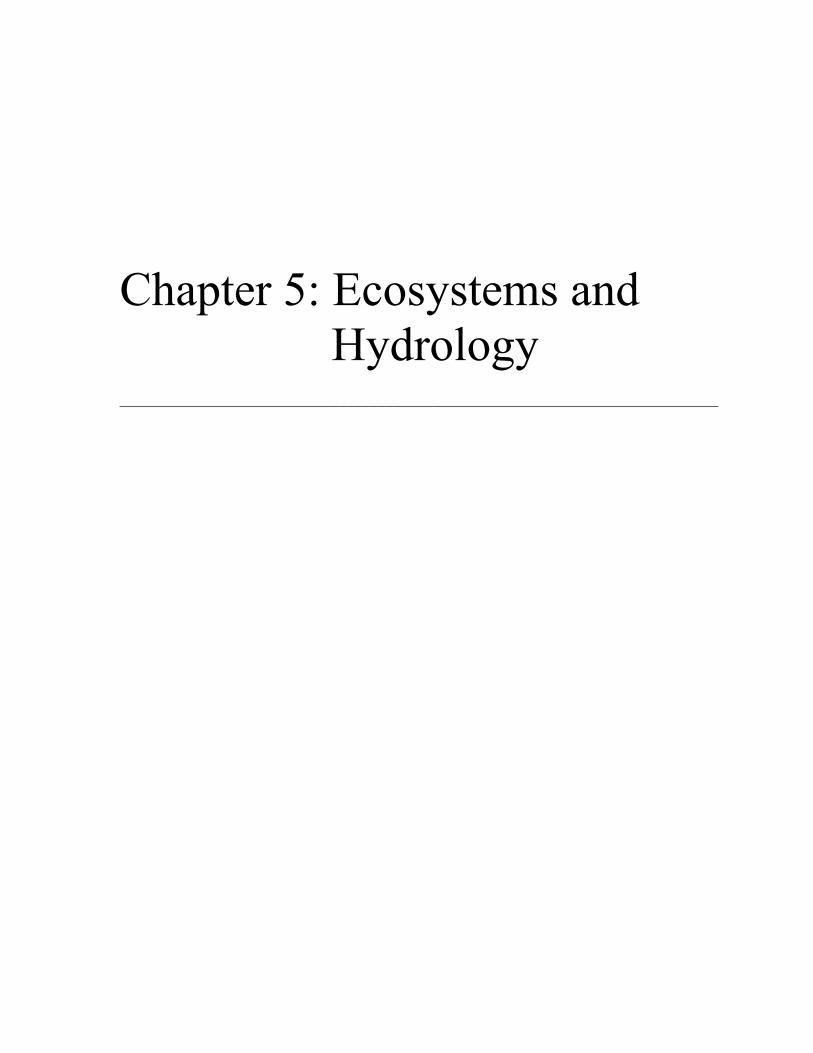
Land managers and researchers can focus on ecosystems at a variety of spatial scales, fromvery large regional units to relatively small local units, depending on their specific interestsand programmatic resources. In this project, the team analyzes ecosystems at a variety ofscales. For example, the rarity of ecosystems in the study area are assessed by examining“landtype associations” as delineated by the Michigan Natural Features Inventory (Corner,1999). The Michigan Natural Features Inventory (MNFI), the United States Forest Service,and others use the term landtype association to describe ecological units that are of anintermediate size, ranging from hundreds to thousands of acres (Table 5.1).
Table 5.1: National hierarchy of ecological units.Planning and
Analysis ScaleEcological Units Purpose, Objectives, and General
UseGeneral Size
Range
ecoregion global continental regional
domaindivisionprovince
� broad applicability formodeling and sampling
� strategic planning andassessment
� international planning
10,000 acres tothousands ofsquare miles
landscape landtypeassociation
� forest or area-wide planning� watershed analysis
hundreds tothousands ofacres
land unit landtypelandtype phase
� project/management areaplanning
� project/ management areaanalysis
less than 10 tohundreds ofacres
Adapted from ECOMAP, USDA Forest Service (1993)
In order to assess the rarity of landtype associations (LTAs), the team looked at LTAs withina broader ecosystem context, specifically looking at all LTAs within the Grayling OutwashPlain sub-subdistrict regional ecosystem (over 2.5 million acres) as delineated by Albert etal., in 1986. The project team also considers smaller scale ecosystems by giving priority towetlands. In the study area, wetland ecosystems range greatly in size from hundreds of acresto less than ten acres.

Chapter 5: Ecosystems and Hydrology 104
WATERSHEDS AND ECOSYSTEMS
As land managers and conservancy groups have increasingly moved toward regional-scaleconservation planning efforts, they have largely relied on watershed boundaries to delineatetheir study areas. In other words, planners are generally using watersheds as their spatialorganizing principle for regional conservation planning efforts. However, ecologists,planners, policy makers, and the general public are gaining a better understanding of theecosystem concept. As a result, planners can increasingly choose ecosystems as their spatialorganizing principle, when appropriate based on their conservation objectives.
Focusing on watersheds in regional conservation planning is both logical and sensible inmany situations. For instance, if an organization is primarily concerned with water qualityissues, water supply, or erosion control, the use of hydrologic boundaries such as watershedsor subwatersheds is more logical than using an ecosystem boundary. Randhir et al., (2001)provide a good example of conservation planning with a watershed focus in “A Watershed-based Land Prioritization Model for Water Supply Protection.” Furthermore, it is oftenadvantageous for land management and conservancy groups to organize their planningefforts according to watersheds because the watershed concept is familiar to both thedecision-makers and respective constituencies of these organizations. It can be particularlysensible for nonprofit conservancy groups to focus on protecting watersheds, funders ofconservancy efforts understand the watershed concept well. However, as ecologists and thegeneral public gain a better understanding of ecosystems, this second rational for focusing onwatersheds loses validity.
Given equal familiarity with watershed and ecosystem concepts, the decision to organizeconservation planning efforts around watersheds versus ecosystems should be based onmanagement objectives. For many regional-scale land management objectives, there areadvantages to organizing planning efforts around ecosystems rather than watersheds.Because ecosystems are whole chunks of interconnected land, water, atmosphere, and biota,an ecosystem focus allows planners and managers to concentrate on whole systems whilealso emphasizing the management of individual components, such as biota. Furthermore, forthe increasing number of organizations specifically interested in ecosystem management andecosystem protection, it may prove useful to conduct planning efforts within large-scalelandscape ecosystems, rather than watersheds.
This project combines the watershed and ecosystem approaches. The study area boundary isbased on subwatersheds, yet the team chose several ecosystem-based conservation drivers.Specifically, the team gave conservation preference to rare landtype associations (local-levelecosystems described later in this chapter), wetland ecosystems, and riparian ecosystems.
A combined ecosystem and watershed approach made sense for this project because the teamis attempting to prioritize lands for conservation in the upper Manistee River watershedbased on ecosystem-focused conservation objectives. The team chose to work in the upperportions of the Manistee River watershed based on the organizational interests of GTRLC.The team chose ecosystem-focused conservation objectives and drivers because of thegrowing belief amongst ecologists and conservationists that in order to protect biodiversity

Chapter 5: Ecosystems and Hydrology 105
and landscape diversity, the diverse set of ecosystems that exists on Earth must be protected(Rowe, 1989; Rowe, 1997).
ECOSYSTEMS OF THE PROJECT STUDY AREA
Depending on their scale, ecosystems can be classified as either regional or local. Albert(1995) identified three hierarchical levels of regional ecosystems (districts, subdistricts, andsub-subdistricts). The team used this regional classification to provide ecological context forthe upper Manistee River watershed project. Local-level landscape ecosystems have alsobeen mapped throughout the study area. Building on Albert’s regional ecosystemclassification, MNFI ecologists mapped the landtype associations of the Highplainssubdistrict (which includes the study area) using field observations and existing data (Corner,1999). Specifically, MNFI delineated the LTAs based on topographic features, soil texture,soil drainage classes, and overstory vegetative cover.
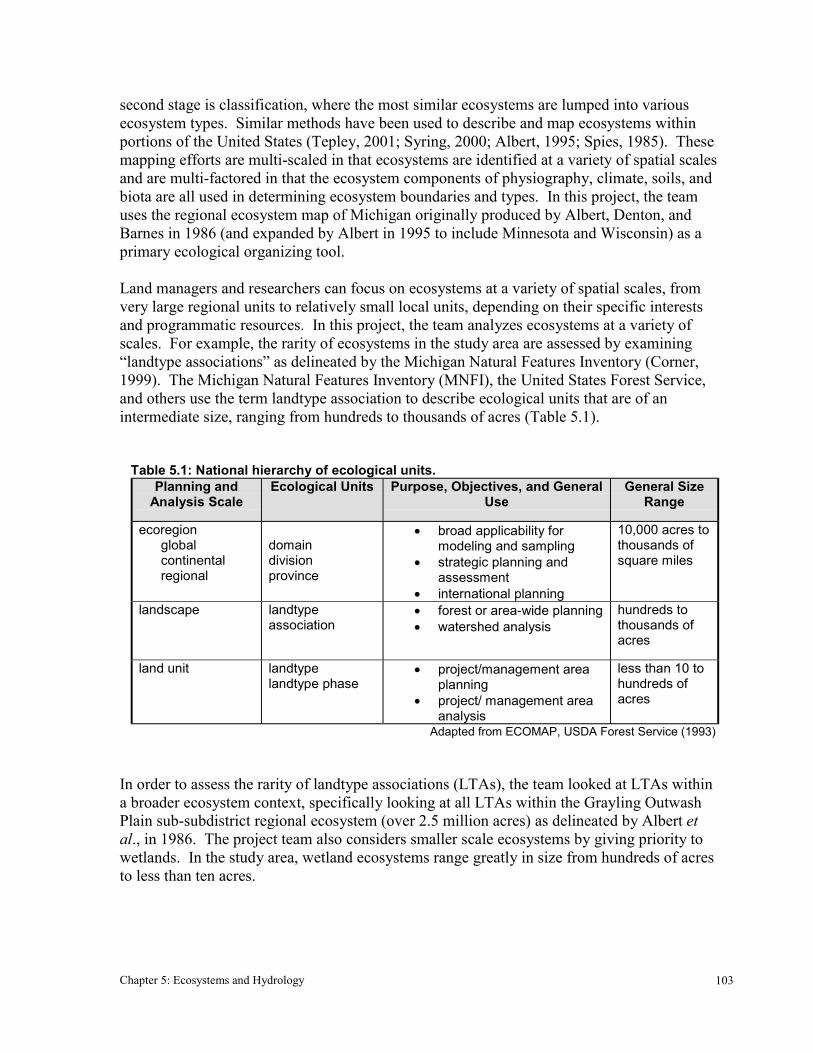
Many ecosystem mapping projects in the United States recognize three general hierarchicallevels of local ecosystems: physiographic systems, landforms, and landscape ecosystemtypes. The LTAs described by MNFI are intermediate in size between physiographicsystems and landforms. A physiographic system is a large topographic feature caused by aunique erosionary, sedimentary, or Earth movement event. A landform, alternatively, is asingle topographic unit, such as a hill or kettle hole depression, situated within a largerphysiographic system. Figure 5.1 depicts the ecosystem hierarchy while Figure 5.2 mapsthem for northern lower Michigan and the study area.
The remainder of this chapter describes three hierarchical regional ecosystems that pertain tothe study area. In addition, the 16 LTAs found in the study area are described based ondescriptions from MNFI (Corner, 1999). MNFI has assigned each LTA a descriptive nameas well as a four-digit numeric code. Although the numeric codes are not emphasized in thisreport, they are included in Table 5.3 for those familiar with the MNFI four-digit system.For convenience, the team assigned simple numeric references (1-17) to the LTAs thatcorrespond with the MNFI four-digit numeric codes. The following descriptions of regionaland local ecosystems are intended to provide the reader with a more detailed picture of thestudy area.
REGIONAL LANDSCAPE ECOSYSTEMS
Much of the detailed information on the following regional ecosystems is summarized inTable 5.2.
District VII: Northern Lacustrine-Influenced Lower Michigan
A large variety of forest cover types flourished in this district before European settlement. Inthe beginning of the 19th Century the forests of northern Lower Michigan were largely
Chapter 5: Ecosystems and Hydrology 106
Figure 5.1: Hierarchy of regional and local ecosystems within the study area, adapted from Albert et al. (1986) and Barnes et al. (1998)
decimated by large-scale deforestation and severe slash burning. Ecosystems hardest hitwere those possessing northern hardwood, white pine, and eastern hemlock cover types.Although the majority of the district is currently forested, because of historical and currentlogging practices, very few sites support late-successional forests. The great majority ofthese forests are second growth areas having formerly experienced deforestation andpotentially cultivation and/or grazing.
District: VIINORTHERN LACUSTRINE-INFLUENCED LOWER MICHIGAN
Subdistrict: VII.2HIGHPLAINS
Sub-subdistrict: VII.2.2GRAYLING OUTWASH PLAIN
Physiographic systems� ice-contact terrain� moraine� outwash plain
Landforms� kame, kettle depression, etc.� end moraine, till plain, etc.� outwash channel, etc.
Landscape ecosystemtypes
MN
FI L
andt
ype
asso
ciat
ions
Reg
iona
l eco
syst
ems
Loca
l eco
syst
ems

Chapter 5: Ecosystems and Hydrology 107
Figure 5.2: Study area and three regional ecosystems: District VII, Subdistrict VII.2, and Sub-subdistrict VII.2.2.
N
0 40 80 120 160 200 Kilometers
Source: Michigan Department of Natural Resources, Michigan Natural Features Inventory
Regional Ecosystem - Section VII
Sub-subsection VII.2.2 - Grayling Outwash Plain
Study area
Subsection VII.2 - Highplains
Subdistrict VII.2: Highplains
The predominant landform in this subdistrict is outwash plain. Before European settlement,these landforms were primarily covered by jack pine/oak barren communities. Thevegetation that dominated these barren systems included various species of grasses, sedges,wildflowers (herbaceous dicots), and two predominant tree species, jack pine (Pinusbanksiana) and northern pin oak (Quercus ellipsoidalis). Today, oak and pine barrens areglobally threatened community types with very little of the original barrens covertyperemaining in the Highplains region. Most of the land that formerly supported barrens hasbeen converted for timber production to red pine (Pinus resinosa), jack pine, or white pine(Pinus strobus) plantations, as well as aspen (Populus tremuloides and P. grandidentata).On the ice-contact and moraine physiographic systems, presettlement forests werepredominantly northern hardwoods dominated by American beech (Fagus grandifolia) andsugar maple (Acer saccharum). Today, these landforms are predominantly covered with acombination of northern hardwood forests, aspen forests, pine plantations, and agriculture.

Chapter 5: Ecosystems and Hydrology 108
Sub-subdistrictVII.2.2: G
raylingO
utwash Plain
Subdistrict VII.2:H
ighplains
District VII:
Northern Lacustrine-
InfluencedLow
er Michigan
Regional
Ecosystem
10,525
21,604
44,323
Area
(km2)
Grow
ing season from 80
-130 days. Severe frostdanger throughoutgrow
ing season. 28 –32” averageprecipitation.Extrem
ely cold minim
umtem
peratures.
Most severe clim
ate inLow
er Michigan.
Grow
ing season from 70
-130 days. 28 -32”average annualprecipitation.G
reat chance of latespring freezes.
Reduced continentality
due to proximity to
Great Lakes. Lake-
effect snows
characteristic within 25
miles of G
reat Lakesshoreline. C
limate
Paleozoic bedrockdeposits includesandstone, coal,shale, andlim
estone.D
epth to bedrock200 -800’.
Paleozoic bedrockdeposits includesandstone, shale,lim
estone, dolomite,
and gypsum. D
epthto bedrock 100-1000’.
Paleozoic bedrockdeposits includesandstone, shale,lim
estone, dolomite,
coal, and gypsum.
Depth to bedrock up
to 1,100’.
Bedrock G
eology
A high outwash plain
where large areas of
sandy outwash
surround severalsandy, ice-contactridges.Elevations range from900 -1580’.
A high plateau, largelycovered by outw
ashplains. O
therlandform
s includeground m
oraines, endm
oraines, and ice-contact ridges.
Entire section coveredduring late W
isconsinG
laciation. Com
mon
physiographic systems
include lake plain,outw
ash plain, andm
oraine.
Physiography
Most soils are of
excessively-drainedsands or sandsm
ixed with gravels.
Deposits of fine-
textured till andlacustrine clays lesscom
mon.
Large outwash
plains areexcessively w
ell-drained sands.M
oraines and ice-contact ridgesprim
arily of sandsalso, w
ith variousdrainage.
Soils range fromsand to clay.M
ost typical soilsare sands, loam
ysands and sandyloam
s of variousSpodosolclassifications.
Soils
Table 5.2: Description of regional ecosystem
hierarchy

Chapter 5: Ecosystems and Hydrology 109
Fire was formerly an important, beneficial disturbance in the drier, upland ecosystems of theHighplains region, particularly in ecosystems with a significant oak component, pine/oakbarrens, and northern prairies. The herbaceous vegetation that is adapted to living in prairiesand barren ecosystems relies on a relatively high frequency of ground fires that serves tolimit the growth of woody vegetation and subsequent shade. Pin oak, an importantcomponent of pine/oak barrens, has bark that is thick enough to resist light fires and can re-sprout after stand-clearing crown fires. Jack pine is entirely dependent on large, stand-clearing fires for regeneration, as its seeds remain tightly enclosed in hardened cones untilreleased by fire.
Foresters have managed for jack pine in the Highplains area for some time, implementingtechniques of clear cutting and replanting. Only recently have foresters in this region begunto consider how to manage for jack pine in ways that promote a more natural character inforest stands. Many of the unique species that are associated with jack pine barrens,including the federally endangered Kirtland’s warbler (Dendroica kirtlandii), have declinedas natural, fire-dependent jack pine forests have been converted into less natural jack pineplantations and other cover types. If managers intend to protect, encourage, or restore oak-dominated ecosystems, northern prairies, and barren ecosystems in the Highplains region, areintroduction of fire will be crucial. Introduction of controlled fires will have to occurgradually because fire has been suppressed in this region for hundreds of years and fuelshave accumulated to dangerous levels.
Sub-subdistrict VII.2.2: Grayling Outwash Plain
Pre-settlement cover types varied greatly in this sub-subdistrict. Major cover types includednorthern hardwoods, jack pine barrens, and swamps dominated by northern white cedar.MNFI has combined knowledge of local ecosystems with an analysis of historical records toestimate the pre-settlement vegetation cover of Michigan (Comer, 1995). Many of the rareplant and animals that are found in this sub-subdistrict are associated with the oak/pinebarrens and northern prairie-savanna complex, and to a lesser extent the northern hardwoodforests. This is likely a reflection of the high conversion rates of these systems to timber andagricultural production. Species associated with these ecosystems that have very specific siterequirements are left with few sites that suit their needs. For a more detailed description ofthe biota found in this sub-subsection, see the following description of study area landtypeassociations.
LOCAL LANDSCAPE ECOSYSTEMS OF THE STUDY AREA
The study area contains 17 different local landscape ecosystems. Table 5.3 providesdescriptions and sizes of each LTA, while Figure 5.3 depicts their locations. See AppendixA for a list of rare plants and animals found in each LTA, and Chapter 7 and Appendix B forthe team’s rarity assessment of each LTA.
LTA 1: Steep, broken moraine ridges; few kettle lakes; excessively-drained sand
There is one area of LTA 1 in the very southern portion of the study area in MissaukeeCounty. It is the eleventh largest LTA in the study area (34.0 square kilometers).

Chapter 5: Ecosystems and Hydrology 110
Table 5.3: Landtype associations of the study area
LTANumber
MNFINumeric
Code
LTA Descriptor Size Rankwithinstudyarea
Areawithin
study area(km2)
Acres withinstudy area
1 1-1-1-1 Moraine ridges; few kettle lakes;excessively-drained sand 11 35.0 8,648
2 1-1-2-1 Moraine ridges; few kettle lakes; well-drained loamy sand 9 56.9 14,066
3 1-2-2-2 Moraine ridges; many kettle lakes; well-drained sandy loam 15 13.9 3,429
4 2-1-1-1 Flat moraine or till plain; excessively-drained sand or loamy sand 13 17.1 4,224
5 2-1-2-1 Flat moraine or till plain; well-drainedsand or loamy sand 14 14.7 3,625
6 2-2-2-1 Broad moraine ridges, few or no lakes;well-drained sand 17 5.6 1,381
7 3-1-1-1 Ice-contact ridges; few kettle lakes;excessively-drained loamy sand 3 150.0 37,073
8 3-1-2-1 Ice-contact ridges; few kettle lakes;well-drained loamy sand 5 125.3 30,967
9 3-1-2-2 Ice-contact ridges; few kettle lakes;well-drained sandy loam 10 48.1 11,888
10 3-2-1-1 Ice-contact ridges; many kettle lakes,excessively-drained sand 12 29.6 7,324
11 5-1-1-1 Broad, flat outwash plain; few lakes;excessively-drained sand 1 245.7 60,720
12 5-1-3-1 Broad, flat outwash plain; few lakes;poorly-drained sand or loamy sand 6 98.5 24,348
13 5-1-4-9 Broad, flat outwash plain; very poorly-drained peat or muck 4 144.8 35,771
14 5-2-1-1 Pitted outwash plain; excessively-drained sand 2 238.6 58,953
15 5-2-2-2 Pitted outwash plain; well-drained tomoderately well-drained sandy loam 8 57.5 14,206
16 5-5-2-1 Narrow outwash channel, well-drainedsand 7 78.8 19,465
17 5-5-4-9 Narrow outwash channel; very poorly-drained peat or muck 16 5.7 1,418
Chapter 5: Ecosystems and Hydrology 111
Although moraine landscapes can take a variety of forms, a unifying characteristic is thepresence of till soils (consists of unsorted sand, silt, and clay particles). However, tills canthemselves vary greatly depending on the relative percentages of sand, silt, and clay presentat a particular site. Morainal soils can be distinguished based on their overall texture as wellas their drainage class, or rate of soil water transfer. The soils of LTA 1 are excessively-drained sands. Moraines can vary greatly in topographic character. LTA type 1 hascharacteristically steep (18-45 percent) slopes along non-continuous or “broken” ridges withrelatively few kettle lakes.
The major, current land covers of LTA 1 are 1) northern hardwoods dominated by Americanbeech and sugar maple, 2) central hardwoods that are similar to northern hardwoods but witha significant red oak (Quercus rubra) component, 3) aspen/white birch (Betula papyrifera),and 4) pine-dominated forests of various compositions.
LTA 2: Steep, broken moraine ridges; few kettle lakes; well-drained loamy sand
LTA 2 is found sporadically along the western portion of the study area, within KalkaskaCounty. It is the ninth largest LTA of the study area (57.0 square kilometers). Thetopography of this LTA is very similar to LTA 1, with steep slopes along broken ridges andfew kettle lakes. A primary difference between LTA 2 and LTA 1 is that the occurrence ofwell-drained loamy sands. These soils are more nutrient rich and hold water better than theexcessively-drained sands of LTA 1. This difference in soil character leads to a higherpercent cover of the mesic northern hardwood forest type and a subsequently higherconversion to agriculture. Primary cover types of this LTA are 1) northern hardwoods, 2)cropland, 3) grass/herb-dominated abandoned fields, 4) pine, and 5) aspen/white birch.
LTA 3: Steep, broken moraine ridges; many kettle lakes; well-drained sandy loam
This LTA type is found scattered along the western portion of the study area in KalkaskaCounty, and is the fifteenth largest (13.9 square kilometers). Topographically, this LTA issimilar to the previous two, however it is dotted with more kettle lakes. Soils are of an evenfiner texture than those of LTA 2, consisting of well-drained sandy loams. Primary covertypes are 1) northern hardwoods, 2) cropland, 3) pine (often plantations), 4) shrub-dominatedabandoned fields, and 5) Christmas tree plantations.
LTA 4: Flat till plain; excessively-drained sand or loamy soil
There is one area of LTA 4 in the study area, occurring in Missaukee County. This is thethirteenth largest LTA of the study area, covering 17.0 square kilometers. Till plains arerelatively flat areas of ice-laid terrain containing unsorted soils. Excessively-drained sandsand loamy sands characterize LTA 4. Although one would expect these excessively-drainedsands to translate into nutrient and water-stressed sites with vegetation adapted to suchstresses, the LTA 4 till plains largely support mesic hardwood forests. This is due to the fact

Chapter 5: Ecosystems and Hydrology 112
Figure 5.3: Landtype associations of the study area
N
0 10 20 30 Kilometers
Source: Michigan Department of Natural Resources, Michigan Natural Features Inventory
LTA Codes:1234567891011121314151617
Study areaLakes and reservoirsRivers and streams

Chapter 5: Ecosystems and Hydrology 113
that till soils, even when predominantly constituted of sand, contain significant proportions ofclay and silt particles that tend to provide available nutrients for plant growth. Furthermore,flat till plain sites occurring at lower elevations and having excessively-drained soils mayhave plenty of available water for plant growth, depending on proximity to the water table.
This LTA type supported 85 percent northern hardwood forests in early to mid-1800’s, ascompared to 45 percent today. Areas that were northern hardwoods in pre-settlement timeshave been converted to pine and Christmas tree plantations and cropland (each of these covertypes now accounts for 13 percent of LTA 4).
LTA 5: Flat till plain: well-drained sand or loamy soil
A single unit of this LTA 5 occurs in the mid-western portion of the study area in KalkaskaCounty. This is the fourteenth largest LTA of the study area, covering 14.7 squarekilometers. LTA 5 is very similar to LTA 4 topographically. The defining differencebetween these two ecosystem types is that LTA 5 has well-drained sands and loamy sandswhere LTA 4 has excessively-drained sand soils. This difference in soil character led to ahigher percent cover of the mesic northern hardwood forest type in presettlement times and asubsequently higher conversion to agriculture. In the early to mid-1800’s, nearly the entireLTA was covered by northern hardwood forest, where as today only 17 percent of the LTA isin this cover type. Cropland currently covers approximately 60 percent of LTA 5, Christmastree plantations nine percent, and other pine plantations eight percent.
LTA 6: Broad moraine ridges: few or no lakes; well-drained sand
LTA 6 occurs in the southwest portion of the study area with one larger unit in KalkaskaCounty and one smaller unit in Missaukee County. This is the smallest of seventeen LTAs,covering 5.6 square kilometers. This LTA is characterized by broad, gently rolling hillscontaining very few scattered lakes and course-textured till soils. The till in LTA 6 isprimarily constituted of sand and is well-drained. The majority of this LTA type wascovered by northern hardwood forest in presettlement times with a significant portion alsocovered by coniferous swamp. Northern hardwood cover has been reduced to 20 percent,with cropland, old field, and pine fores making up the remainder of the LTA.
LTA 7: Irregular ice-contact ridges; few kettle lakes; excessively-drained loamy sand
This LTA occurs throughout the eastern and southern portions of the study area in Kalkaska,Crawford, and Missaukee counties. This is the third largest LTA of the study area, covering150 square kilometers. LTA 7 is characterized by steep, irregular slopes, ranging from six to45 percent slope with excessively-drained gravely sands. In pre-settlement times, a diversemosaic of fire frequencies and plant communities existed in this LTA due to its variable soilsand topography and overall dry conditions. Presettlement cover types of LTA 7 werepredominantly various pine communities, including pine/oak barrens, red pine/white pine,
Chapter 5: Ecosystems and Hydrology 114
and eastern hemlock. Today, pine forests only cover 12 percent, with an additional 30percent of the LTA converted to aspen/birch and 45 percent in northern and centralhardwoods. This LTA supports numerous species of rare plants and animals, most of whichare associated with open, fire dependent ecosystems.
LTA 8: Large, irregular ice-contact ridges; few kettle lakes; well-drained loamy sand
LTA 8 covers several portions of the study area in eastern Kalkaska County. This is the fifthlargest LTA of the study area, covering 125.3 square kilometers. This LTA is very similar intopography to LTA 7, however, the soil is of a slightly finer texture, with less of a gravelcomponent. This difference in soil texture makes LTA 8 less water stressed overall thanLTA 7. This increase in available soil water has led to less fire-prone sites and a largercomponent of mesic northern hardwood forests. Northern hardwoods currently coverapproximately 70 percent of this LTA as they did in the early to mid-1800’s.
LTA 9: Large, irregular ice-contact ridges; few kettle lakes; well-drained sandy loam
There is one large unit of LTA 9 occurring along the eastern border of the study area. This isthe tenth largest LTA of the study area, covering 48.1 square kilometers. This LTA is verysimilar to LTA 8, but with slightly finer textured soil and moister conditions overall. As aresult, the pre-settlement forests of this LTA were almost entirely mesic northern hardwoods.Today only 45 percent northern hardwoods on LTA 9, with over 30 percent having beenconverted to aspen/birch.
LTA 10: Large, irregular ice-contact ridges; many kettle lakes; excessively-drained sand
LTA 10 occurs as one large unit in the center of the study area. This is the twelfth largestLTA of the study area, covering 29.6 square kilometers. This LTA differs from the previousice-contact LTAs in having many kettle lakes, ranging in size from about five to forty acres.This difference in component landforms is a significant factor affecting the diversity of locallandscape ecosystem types. As with the previous ice-contact LTAs, LTA 10 has steep,irregular topography. Soils in this LTA are excessively-drained sands. A diversity of covertypes made up this LTA in presettlement times, including red pine/white pine (almost 50percent), white pine/eastern hemlock, eastern hemlock/American beech, northern hardwoods,and swamps of various composition. The former mixed pine forests have been almostentirely replaced by aspen/birch forests. Other current cover types include northern andcentral hardwoods.
LTA 11: Broad, flat outwash plain; few kettle lakes; excessively-drained sand
This is the largest LTA in the study area, covering 245.7 square kilometers. LTA 11 occursas large units throughout the study area. The topography of LTA 11 is generally flat to
Chapter 5: Ecosystems and Hydrology 115
gently rolling. Excessively-drained sands dominate the LTA. Fire prone conifer forests suchas pine/oak barrens and jack pine forests formerly covered this LTA. Currently, pine forestsare still common, however they are most typically jack or red pine plantations that are muchless biologically and ecologically diverse than the presettlement forests. LTA 11 supportsmany rare plant and animal species that have a diversity of site and habitat requirements,respectively.
LTA 12: Broad, flat outwash plain; poorly-drained sand or loamy sand
This LTA occurs as a large area in Kalkaska and Missaukee counties and straddles themainstem Manistee in the southwestern portion of the study area. This is the sixth largestLTA of the study area, covering 98.5 square kilometers. The topography of this LTA isprimarily flat with areas of undulating and hummocky character as well. Soils vary but areprimarily poorly-drained sands and loamy sands. This was one of the most heterogeneousLTAs in the Highplains subdistrict sampled by MNFI. The topography, soils, and covertypes vary greatly across LTA 12. Historic cover types included mixed conifer swamps,eastern hemlock/white pine, northern hardwoods, and red pine/white pine forests.Aspen/white birch has become a dominant cover type, whereas eastern hemlock forests havevirtually disappeared. Conifer swamp coverage has also reduced significantly in this LTA.
LTA 13: Broad, flat outwash plain; very poorly-drained peat or muck
LTA 13 occurs throughout the study area in Kalkaska, Crawford, and Missaukee counties.This is the fourth largest LTA of the study area, covering 144.8 square kilometers.Topography in this LTA is generally flat and soils are primarily of poorly-drained peat andmuck. In the early to mid-1800’s nearly conifer swamps covered 70 precent of this LTA, andred pine/white pine and eastern hemlock communities covered much of the remainder of theLTA. A shift has occurred on much of the swampland in LTA 13 from lowland conifers tolowland hardwoods. This is due at least in part to the browsing of northern white cedar(Thuja occidentalis) by white-tailed deer. This browsing pressure severely limits northernwhite cedar regeneration. Currently, conifer swamps cover only 22 percent of the LTA andhardwood swamps now cover 16 percent. Other cover types include shrub wetlands,aspen/white birch (increased in coverage from one percent pre-settlement to 21 percenttoday), pine dominated forests, and northern hardwoods. Numerous rare plant and animalspecies occur within LTA 13.
LTA 14: Pitted outwash plain; excessively-drained sand
LTA 14 occurs throughout the study area in Antrim, Otsego, Kalkaska, and Missaukeecounties. This is the second largest LTA of the study area, covering 238.6 square kilometers.Topography in this LTA varies from flat to undulating to pitted, with hills, ice-blockdepressions, and ridges occurring locally. Soils are excessively-drained sands. A diverse setof various pine-dominated forest cover types existed on over 50 percent of LTA 14 in the
Chapter 5: Ecosystems and Hydrology 116
early to mid-1800s; northern hardwood forests occupied over 30 percent. This LTA hasbecome very fragmented with very few large areas of any single cover type. The coverage ofpine-dominated forests has declined from over 50 percent to 19 percent, with much of whatremains occurring as red pine and jack pine plantations. This LTA is very similar to LTA 11but with more topographic variability and more kettle lakes. Rare plant and animals foundhere are similar to those of LTA 11.
LTA 15: Pitted outwash plain; well-drained to moderately well-drained sandy loam
This LTA occurs as one large unit in Kalkaska County. This is the eighth largest LTA of thestudy area, covering 57.5 square kilometers. Topography is undulating with few kettle lakes.Well-drained to moderately well-drained sandy loam soils provide adequate moisture andnutrient to support northern hardwood forests. Pre-settlement land cover was almost entirelynorthern hardwoods in LTA 15. Conversion to agriculture has occurred on 40 percent of thisLTA. Most of the remainder of the land is second growth northern hardwoods.
LTA 16: Narrow outwash channel; well-drained sands
This LTA occurs as one large unit in the east-central portion of the study area and one smallunit along the study area’s eastern border. This is the seventh largest LTA of the study area,covering 78.8 square kilometers. Topography in LTA 15 is mostly level, and soils arepredominately well-drained sands. Presettlement vegetation included white pine/hemlockand American beech/red maple forests, as well as a significant portion of wetlands (primarilyconifer swamps). Current vegetation is predominately aspen/white birch forests. Other landcovers include pine forests, herbaceous rangeland and northern hardwoods.
LTA 17: Narrow outwash channel; very poorly-drained peat or muck
This LTA occurs as one unit in the eastern portion of the study area. This is one of thesmallest LTAs in the study area, covering 5.7 square kilometers. Topography is primarilylevel with steep valley walls occurring along channel edges. Soils are typically poorly-drained peat or muck. Pre-settlement vegetation was primarily conifer swamp occurring inthe poorly-drained channels, with upland pine forest occurring on better drained valley walls.Current land cover is a combination of conifer and hardwood swamp, shrub and emergentmarsh. A variety of rare plant and animal species occur in the vast wetland and localizedxeric areas of LTA 17.
HYDROLOGY OF THEMANISTEE RIVER WATERSHED
In any given area, diverse sets of hydrologic processes strongly influence the successionaldevelopment, function, and structure of the area’s landscape and waterscape ecosystems.
Chapter 5: Ecosystems and Hydrology 117
Hydrologic processes are particularly significant in the study area and therefore warrantspecial attention. The project team felt that hydrology deserved special attention for anumber of reasons, including:
� Hydrologic uniqueness – The hydrology of the Manistee River Basin is extremelyunique when compared to other rivers in Michigan and across the county.
� Hydrologic significance – Many of the biological resources of the study area aredependent on the unique hydrological characteristics of the watershed.
� Hydrologic variability – While hydrology is an important factor in ecosystems, theremay be significant changes in hydrology between subwatersheds that are not reflectedin specific ecosystems described separately in this report.
THE MANISTEE RIVER WATERSHED
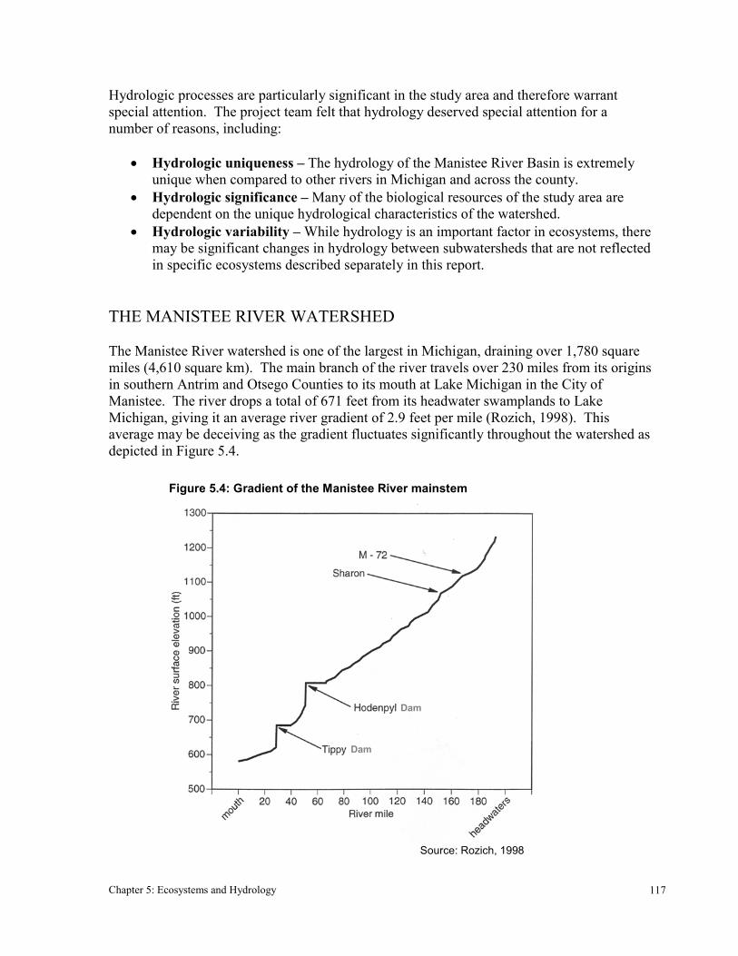
The Manistee River watershed is one of the largest in Michigan, draining over 1,780 squaremiles (4,610 square km). The main branch of the river travels over 230 miles from its originsin southern Antrim and Otsego Counties to its mouth at Lake Michigan in the City ofManistee. The river drops a total of 671 feet from its headwater swamplands to LakeMichigan, giving it an average river gradient of 2.9 feet per mile (Rozich, 1998). Thisaverage may be deceiving as the gradient fluctuates significantly throughout the watershed asdepicted in Figure 5.4.
Figure 5.4: Gradient of the Manistee River mainstem
Source: Rozich, 1998
Dam
Dam
Chapter 5: Ecosystems and Hydrology 118
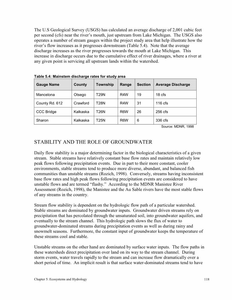
The U.S Geological Survey (USGS) has calculated an average discharge of 2,001 cubic feetper second (cfs) near the river’s mouth, just upstream from Lake Michigan. The USGS alsooperates a number of stream gauges within the project study area that help illustrate how theriver’s flow increases as it progresses downstream (Table 5.4). Note that the averagedischarge increases as the river progresses towards the mouth at Lake Michigan. Thisincrease in discharge occurs due to the cumulative effect of river drainages, where a river atany given point is servicing all upstream lands within the watershed.
Table 5.4: Mainstem discharge rates for study area
Gauge Name County Township Range Section Average Discharge
Mancelona Otsego T29N R4W 19 18 cfs
County Rd. 612 Crawford T28N R4W 31 116 cfs
CCC Bridge Kalkaska T26N R6W 26 256 cfs
Sharon Kalkaska T25N R6W 6 336 cfs Source: MDNR, 1998
STABILITY AND THE ROLE OF GROUNDWATER
Daily flow stability is a major determining factor in the biological characteristics of a givenstream. Stable streams have relatively constant base flow rates and maintain relatively lowpeak flows following precipitation events. Due in part to their more constant, coolerenvironments, stable streams tend to produce more diverse, abundant, and balanced fishcommunities than unstable streams (Rozich, 1998). Conversely, streams having inconsistentbase flow rates and high peak flows following precipitation events are considered to haveunstable flows and are termed “flashy.” According to the MDNR Manistee RiverAssessment (Rozich, 1998), the Manistee and the Au Sable rivers have the most stable flowsof any streams in the country.
Stream flow stability is dependent on the hydrologic flow path of a particular watershed.Stable streams are dominated by groundwater inputs. Groundwater driven streams rely onprecipitation that has percolated through the unsaturated soil, into groundwater aquifers, andeventually to the stream channel. This hydrologic path slows the flux of water togroundwater-dominated streams during precipitation events as well as during rainy andsnowmelt seasons. Furthermore, the constant input of groundwater keeps the temperature ofthese streams cool and stable.
Unstable streams on the other hand are dominated by surface water inputs. The flow paths inthese watersheds direct precipitation over land on its way to the stream channel. Duringstorm events, water travels rapidly to the stream and can increase flow dramatically over ashort period of time. An implicit result is that surface water-dominated streams tend to have

Chapter 5: Ecosystems and Hydrology 119
more severe flooding events than stable groundwater-dominated streams. Surface water-fedstreams also tend to contain warmer water with greater temperature variability.
A stream’s hydrologic flow path is dependent on the soil texture and topography of adjacentuplands. In Michigan, streams flow through glacially derived landforms that vary widely intopography and soil parent material. For most of its course, the Manistee River travelsthrough relatively high elevation landforms consisting of coarse-textured soils such as sandand gravel. These landforms tend to generate groundwater-dominated stream systems.Water drains readily through coarse textured soils because of the large pore spaces that formbetween the relatively large three-dimensional soil particles. Additionally, in areas wheretopography is steeply sloped, soil drainage is further accelerated. Taken together, thesefactors result in a groundwater dependent river system.
In contrast, streams that flow through lower-lying landforms containing fine textured soilssuch as silts and clays tend to be surface water-dominated. Porosity is low in silt and claysoils because the particles are microscopic, flat, and tightly packed together. Additionally,these low elevation landforms tend to be more gently sloping. As a result, water does notdrain well but perches over these heavy soils, flowing primarily above ground on its path tonearby surface water features. Michigan streams are not simply either groundwater orsurface water-fed, but rather they occur along a continuum between these two extremeexamples (Corner 1999). The Manistee falls far to one end of this continuum in that it isvery much groundwater dependent and is extremely stable.
MAIN BRANCH STREAM CHARACTERISTICS
The physical characteristics of the Manistee River fluctuate along the river’s length. Theriver’s upper most reaches (north of M-72) are shallow, meandering, and littered with woodydebris. Further down the river, past highway M-72, the river begins to widen and woodydebris becomes less common. Short and fast riffles are also common through this stretch ofthe river. By the time the river reaches Smithville its average depth, width, and flow haveincreased substantially (MDNR, 1998).
WETLANDS
Wetlands are the interface between aquatic and terrestrial ecosystems. Many wetlands arecovered by water in the spring and fall (aquatic), but dry in the summer and winter months(terrestrial). 12.8% (43,690 acres) of the Manistee River watershed is covered by wetlandecosystems, including lakes. These areas are found where landscape patterns causegroundwater to surface, or prevent water from percolating into the soil profile. There are awide variety of wetlands in the Manistee region. Wetlands can be found on both level andsloped terrain, along the margins of lakes and streams or surrounded by upland. They can becomposed of tree, shrub, graminoid, and bryophyte-dominated communities.

Chapter 5: Ecosystems and Hydrology 120
Wetlands provide a wide range of ecological benefits. The Manistee headwaters originate asgroundwater seeps in a rich cedar swamp in Antrim County (Rozich 1998). These headwaterwetlands start the river off with cool temperatures and stable flows. Wetlands also serve asfilters for streams and lakes, holding up erosionary sediments and nutrient loads that wouldotherwise flow into water bodies. In the Manistee watershed, wetlands are some of the mostbiologically diverse ecosystems. See Chapter 2 for more information on the ecological andhydrological values of wetlands.