Embed Size (px)
Citation preview

Chapter 5–New occurrence of oil-stained rocks–the Middle Jurassic Cynthia Falls Formation, Tuxedni Group 23
CHAPTER 5
A NEW OCCURRENCE OF OIL-STAINED ROCKS WITHIN A SMALL FAULT ZONE INVOLVING THE MIDDLE JURASSIC CYNTHIA FALLS FORMATION, TUXEDNI GROUP, NORTHERN INISKIN PENINSULAMarwan A. Wartes1 and Trystan M. Herriott1
INTRODUCTIONThe Iniskin Peninsula of western Cook Inlet (fig. 5-1) has long been known as a prospective region for hydrocarbons due to surface oil and gas seeps, which were recognized by Russian observers in 1853 and are among the first documented seeps in Alaska (Martin, 1905). Geologic investigations that addressed the seeps and industry exploration continued intermit-tently for the first half of the twentieth century (Martin and Katz, 1912; Moffit, 1927; Detterman and Hartsock, 1966), but subsequent studies have been limited (for example, Blasko, 1976).
The most detailed geologic analysis of the Iniskin Peninsula is provided in the seminal U.S. Geological Survey Professional Paper 512, by Detterman and Hartsock (1966). Their mapping suggested that the seeps are likely controlled by faults or closely-spaced joints. Furthermore, their summary of the hydrocarbon shows from three exploration wells on the Iniskin Peninsula indicated that the presence of oil and gas was associated with steeply dipping joints and fault zones intersected by the wells. The lack of evidence for significant porosity in the unfaulted Jurassic strata also suggested that structures were serving as the main conduit for fluid migration.
Detterman and Hartsock (1966) projected their mapped faults into areas where oil was seeping through Quaternary cover. However, they did not document any oil-stained outcrops associated with a mapped structure. The purpose of this report is to briefly describe a newly discovered outcrop of oil-stained rocks on the Iniskin Peninsula that is preferentially charged within the damage zone of a small fault. We conclude by briefly discussing some of the larger questions surrounding the timing of hydrocarbon maturation, migration, and tectonic deformation that are key to better understanding the petroleum system in the region.
NEW FAULT-RELATED OIL-STAINED LOCALITY2
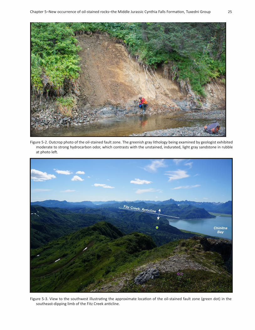
During the course of constructing a detailed geologic map of the Iniskin Peninsula (see project overview [chapter 1, this volume]), a locality exhibiting a moderate to strong petroliferous odor was discovered along Park Creek (fig. 5-1). Outcrops along the northwest bank of the creek are discontinuous and often partially covered; exposure quality at the oil-stained local-ity is enhanced by recent slumping of overlying colluvium and vegetation (fig. 5-2). Our mapping indicates the exposure is in the upper part of the Middle Jurassic Cynthia Falls Sandstone of the Tuxedni Group and lies in the southeast limb of the Fitz Creek anticline (figs. 5-1 and 5-3).
The oil-stained zone occupies the central part of the cutbank exposure and consists of dark greenish-gray, argillaceous sandstone (fig. 5-2). The interval is friable and exhibits evidence of shearing, including phacoid development and probable fault gouge. On either side of the fault, the exposed rock has no detectable hydrocarbon odor and consists of undeformed, light gray- and tan- to brown-weathering, well-indurated, fine-grained feldspathic graywacke. The sandstone also contains coalified wood fragments. The magnitude of offset and orientation of the fault zone are unclear, but the structure is subverti-cal and likely strikes approximately east–west.
Limited exposure hampers mapping of the oil-stained fault beyond the immediate outcrop. However, the inferred orienta-tion is consistent with a number of other faults and fracture swarms on the peninsula that were described as ‘cross faults’ by Detterman and Hartsock (1966). Approximately 2 miles east of Park Creek, two subvertical faults cut across the Tilted Hills, offsetting the Chinitna and Naknek Formations (chapter 2, this volume). These faults are well exposed in the head-waters of Sinking and Covey creeks, yielding apparent north-side-up stratigraphic separations. Detterman and Hartsock (1966) mapped only the more northern fault along upper Sinking Creek (reproduced in fig. 5-1). The fault observed in upper Covey Creek (chapter 2, this volume) strikes approximately 110 degrees and may be the same fault noted at the oil-stained locality. Regardless, these faults are part of a family of structures oriented approximately perpendicular to the major fold axes on the Iniskin Peninsula (Detterman and Hartsock, 1966).
1Alaska Division of Geological & Geophysical Surveys, 3354 College Rd., Fairbanks, Alaska 99709-3707; [email protected]; [email protected]
2Location coordinates: N59.81157°; W153.10051° (NAD27AK)

24 PIR 2014-2: COOK INLET PROGRAM 2013 FIELD STUDIES: OBSERVATIONS AND PRELIMINARY INTERPRETATIONS
Figure 5-1. Location map of southern Alaska (upper left); shaded-relief map of western Cook Inlet (upper right); geologic map of the northern Iniskin Peninsula (bottom), modified from Detterman and Hartsock (1966). Key to map unit ab-breviations and stratigraphic order is shown in the middle left.
Chapter 5–New occurrence of oil-stained rocks–the Middle Jurassic Cynthia Falls Formation, Tuxedni Group 25
Figure 5-2. Outcrop photo of the oil-stained fault zone. The greenish gray lithology being examined by geologist exhibited moderate to strong hydrocarbon odor, which contrasts with the unstained, indurated, light gray sandstone in rubble at photo left.
Figure 5-3. View to the southwest illustrating the approximate location of the oil-stained fault zone (green dot) in the southeast-dipping limb of the Fitz Creek anticline.

26 PIR 2014-2: COOK INLET PROGRAM 2013 FIELD STUDIES: OBSERVATIONS AND PRELIMINARY INTERPRETATIONS
Samples were collected for petrographic assessment of sandstone composition and porosity and permeability measurements. Additional samples were retained for hydrocarbon extraction; the organic geochemistry of the hydrocarbons will be com-pared against existing isotopic and biomarker data from rocks in the lower Tuxedni Group, which are widely regarded as the principal oil-prone source rock in the basin (Magoon and Anders, 1992). The results of these analyses will be published in forthcoming reports.
DISCUSSIONThe discovery of oil-stained rocks on the Iniskin Peninsula builds on the numerous previous indications of an active petro-leum system in the region (for example, Magoon, 1994). The recognition of hydrocarbons concentrated in a fault zone is the first outcrop-based evidence that structural deformation is at least locally responsible for creating pore fluid space. This occurrence, although isolated, offers support for previous conjectures regarding the important role of fractures in control-ling the location of surface seeps elsewhere on the Iniskin Peninsula (Detterman and Hartsock, 1966). Further, despite the generally low porosity and permeability of the Jurassic section (Helmold and others, 2013), the association of hydrocarbons with intensely fractured rock may indicate the potential for unconventional Mesozoic reservoirs in the subsurface (Gillis and others, 2013; LePain and others, 2013).
The fact that undeformed facies bounding the fault zone are not perceptibly hydrocarbon charged implies that they did not possess sufficient reservoir quality during migration, or that the fault zone was a strongly preferred conduit for fluids. This observation may also suggest that diagenetic cementation predated either the faulting or oil migration or both. The cross faults and associated joints on the Iniskin Peninsula are here interpreted as being related to the development of the large, northeast-trending folds. Map relations suggest at least three episodes of deformation affected the western side of Cook Inlet (Detterman and Hartsock, 1966; Magoon and others, 1980), although the timing of faulting on the Iniskin Peninsula remains poorly constrained. Assessing the timing of this deformation is critical to understanding the petroleum system in this area, particularly with respect to when maturation and migration occurred. Unfortunately, the timing of oil generation remains poorly constrained in many parts of the basin (Magoon, 1994; LePain and others, 2013). Nevertheless, two potential scenarios include: (1) early fault/joint development, followed by later burial into the oil window, driving expulsion, or (2) the source rocks could have matured prior to faulting, with migration pathways only developing during later deformation.
In order to address the relative timing of deformation and oil expulsion/migration, an extensive suite of thermochronology samples were collected across the peninsula. These data may shed light on the timing of cooling and exhumation of the Jurassic stratigraphy. Ultimately, integration of this exhumation record with ongoing structural and stratigraphic studies will yield additional insight into the burial, maturation, uplift/deformation, and migration history of the petroleum system in lower Cook Inlet.
ACKNOWLEDGMENTSWe thank Rebekah Tsigonis for field assistance and camp support; Rick Stanley (U.S. Geological Survey) and Ken Helmold (Alaska Division of Oil & Gas) for constructive conversations in the field; Mike Fell (Pathfinder Aviation) for helicopter support; Merril and Marti (Bear Mountain Lodge) for their hospitality; Jack Barber (Alaska Air Taxi); Bald Mountain Air; and David LePain for careful review of this report. The Iniskin Peninsula area mapping project was funded by a substantial contribution from the U.S. Geological Survey STATEMAP Program (award no. G13AC00157).
REFERENCES CITEDBlasko, D.P., 1976, Oil and gas exploration on the Iniskin Peninsula, Alaska: U.S. Bureau of Mines Open-File Report 76-
69, 19 p.
Detterman, R.L., and Hartsock, J.K., 1966, Geology of the Iniskin–Tuxedni Peninsula region, Alaska: U.S. Geological Survey Professional Paper 512, 78 p., 7 plates.
Gillis, R.J., Maley, M.R., Frohman, R.A., and Peterson, C.S., 2013, Fracture studies in Upper Cretaceous and Upper Jurassic strata on the upper Alaska Peninsula and lower Cook Inlet, in Gillis, R.J., ed., Overview of 2012 field studies—Upper Alaska Peninsula and west side of lower Cook Inlet, Alaska: Alaska Division of Geological & Geophysical Surveys Preliminary Interpretive Report 2013-1D, p. 13–17.
Helmold, K.P., LePain, D.L., Wilson, M.D., and Peterson, C.S., 2013, Petrology and reservoir potential of Tertiary and Mesozoic sandstones, Cook Inlet, Alaska—A preliminary analysis of outcrop samples collected during 2007–2010 field seasons: Alaska Division of Geological & Geophysical Surveys Preliminary Interpretive Report 2013-5, 34 p.

Chapter 5–New occurrence of oil-stained rocks–the Middle Jurassic Cynthia Falls Formation, Tuxedni Group 27
LePain, D.L., Stanley, R.G., and Helmold, K.P., 2013, Geologic framework and petroleum systems of Cook Inlet basin, south-central Alaska, in Stone, D.M., and Hite, D.M., eds., Oil and Gas Fields of the Cook Inlet Basin: American As-sociation of Petroleum Geologists Memoir 104, p. 37–116.
Magoon, L.B., 1994, Tuxedni–Hemlock(!) petroleum system in Cook Inlet, Alaska, U.S.A., in Magoon, L.B., and Dow, W.G., eds., The Petroleum System—From Source to Trap: American Association of Petroleum Geologists Memoir 60, p. 359–370.
Magoon, L.B., and Anders, D.E., 1992, Oil-to-source-rock correlation using carbon-isotopic data and biological marker compounds, Cook Inlet—Alaska Peninsula, Alaska, in Moldowan, J.M., Albrecht, Pierre, and Philp, R.P., eds., Biologi-cal markers in sediments and petroleum: Englewood Cliffs, N.J., Prentice-Hall, p. 241–274.
Magoon, L.B., Griesbach, F.B., and Egbert, R.M., 1980, Nonmarine Upper Cretaceous rocks, Cook Inlet, Alaska: American Association of Petroleum Geologists Bulletin, v. 64, p. 1,259–1,266.
Martin, G.C., 1905, Notes on the petroleum fields of Alaska, in U.S. Geological Survey, Report of progress on investigations of mineral resources in Alaska in 1904: U.S. Geological Survey Bulletin 259, p. 128–129.
Martin, G.C., and Katz, F.J., 1912, A geologic reconnaissance of the Iliamna region, Alaska: U.S. Geological Survey Bul-letin 485, 138 p., 2 sheets, scale 1:250,000.
Moffit, F.H., 1927, The Iniskin–Chinitna Peninsula and the Snug Harbor district, Alaska: U.S. Geological Survey Bulletin 789, 71 p., 5 sheets, scale 1:250,000.
![Simultaneous occurrence of chronic myeloid leukemia and ... · May-Grünwald Giemsa stained bone marrow aspira ti on - hypercellular ... Hatt ori et al.[17] 68 F 24 Months CLL following](https://img.pdfslide.us/doc/110x75/5d33f51988c993492e8dcea0/simultaneous-occurrence-of-chronic-myeloid-leukemia-and-may-gruenwald-giemsa.jpg)

![Fluoride Occurrence and Human Health Risk in Drinking ...Fluoride occurs in granitoids, metamorphic rocks, igneous, and sedimentary rocks [15]. In most cases, enrichment of fluoride](https://img.pdfslide.us/doc/110x75/60e0ddab117ab81d190ef9ad/fluoride-occurrence-and-human-health-risk-in-drinking-fluoride-occurs-in-granitoids.jpg)