Embed Size (px)
Citation preview
4.4.12-1
Chapter 4.4.12: Parks and Recreational Resources
4.4.12-1 INTRODUCTION
This chapter evaluates the long-term effects of the Portageville Bridge Project on parks and recreational resources. Specifically, it assesses the potential impacts of the Project under Alternatives 4 and 5 on Letchworth State Park and discusses consistency with relevant federal and state policies, programs, and regulations intended to protect parkland from adverse effects. The impacts of construction activities for the Project on Letchworth State Park’s recreational features are evaluated in Chapter 4.5, “Construction Impacts.” This chapter considers the permanent effects of the Project on the park’s recreational features.
4.4.12-2 METHODOLOGY
This chapter was prepared in accordance with a number of different regulations and programs intended to protect parkland, including the following:
New York State Heritage Area Program: New York State’s Heritage Area System (formerly known as the Urban Cultural Park System) is intended to preserve and develop areas that have special significance to the state, because they reflect the cultural themes of the state's development and provide educational, inspirational, economic, and recreational benefits. There are 18 heritage areas in the state.
National Heritage Areas Program: Congress has designated 49 National Heritage Areas, where the natural, cultural, historic, and scenic resources are considered uniquely representative of the American experience. These areas, including public and private lands, receive funds and assistance through cooperative agreements with the National Park Service.
National Registry of Natural Landmarks: As set forth in 36 CFR Part 62, a National Natural Landmark “is an area designated by the Secretary of the Interior as being of national significance to the United States because it is an outstanding example(s) of major biological and geological features found within the boundaries of the United States or its Territories or on the Outer Continental Shelf.” Properties that are designated as National Natural Landmarks may be in public or private ownership. Such designation does not change the ownership of an area and does not dictate activity, but one of the objectives of the NNL program is that owners and federal, state and local government agencies will take the designation into account when making planning or other future land use decisions.
Section 4(f): Section 4(f) of the U.S. Department of Transportation (USDOT) Act of 1966 (now 49 USC § 303) prohibits the Secretary of Transportation from approving any program or project that requires the use of: (1) any publicly owned land in a public park, recreation area, or wildlife and waterfowl refuge of national state, or local significance, or (2) any land from a historic site of national, state, or local significance (collectively, “Section 4(f) resources”), unless there is no feasible and prudent alternative to the use of such land and all possible planning has been undertaken to minimize harm to the 4(f) resource. The Project is not subject to review by the U.S. Department of Transportation, because the Project budget does not include any federal transportation funds, nor are any permits or
Portageville Bridge DEIS PIN 4935.79.101
4.4.12-2
approvals required from any federal transportation agencies. Therefore, Section 4(f) does not apply to the Portageville Bridge Project.
Section 6(f): Section 6(f) of the Land and Water Conservation Fund Act (LWCFA) of 1965 (now 16 USC § 460i-4) requires that any property acquired and/or developed with LWCFA funds remain forever available for public outdoor recreation use or be replaced by lands of equal market value and recreational usefulness. The U.S. Department of the Interior (DOI), through the National Park Service (NPS), provides funding under the LWCFA for state and local efforts to plan, acquire, or develop land to advance outdoor recreational activities. The New York State Office of Parks, Recreation and Historic Preservation (OPRHP) serves as the New York State agency that administers LWCF funds received from DOI. Using LWCFA funds creates certain limitations on future changes to LWCFA-funded projects. Once LWCFA funds are used for a particular recreation project, conversion of that park facility for any non-recreational purpose (either permanently or on a temporary basis for greater than six months) is conditioned on NPS approving such non-recreational use in accordance with Section 6(f). Prior approval by NPS is required for the conversion and replacement of parkland subject to this regulation, and any NPS approval must be based on a determination that the conversion meets the conditions required under Section 6(f).
Section 1010: The Urban Park and Recreation Recovery Act (UPARRA) of 1978 (16 USC § 2501) was created by Congress to “assist physically and economically distressed urban jurisdictions to revitalize their recreation systems, and to enhance overall recreation opportunities through the use of existing and potential recreation resources.” Under UPARRA, conversion of existing parkland that has received UPARRA funding to a non-park use can be granted by DOI through the National Park Service only if alternatives have been evaluated and steps are taken to identify, evaluate, and supply replacement parkland.
Parkland Alienation Principles: Parkland “alienation” occurs when a municipality wishes to discontinue or convey municipal parkland. This conveyance is done in the form of a “parkland alienation” bill granted by the New York State Legislature and approved by the Governor.
4.4.12-3 EXISTING CONDITIONS
4.4.12-3-1 Parks and Recreational Resources: Letchworth State Park
Park Overview
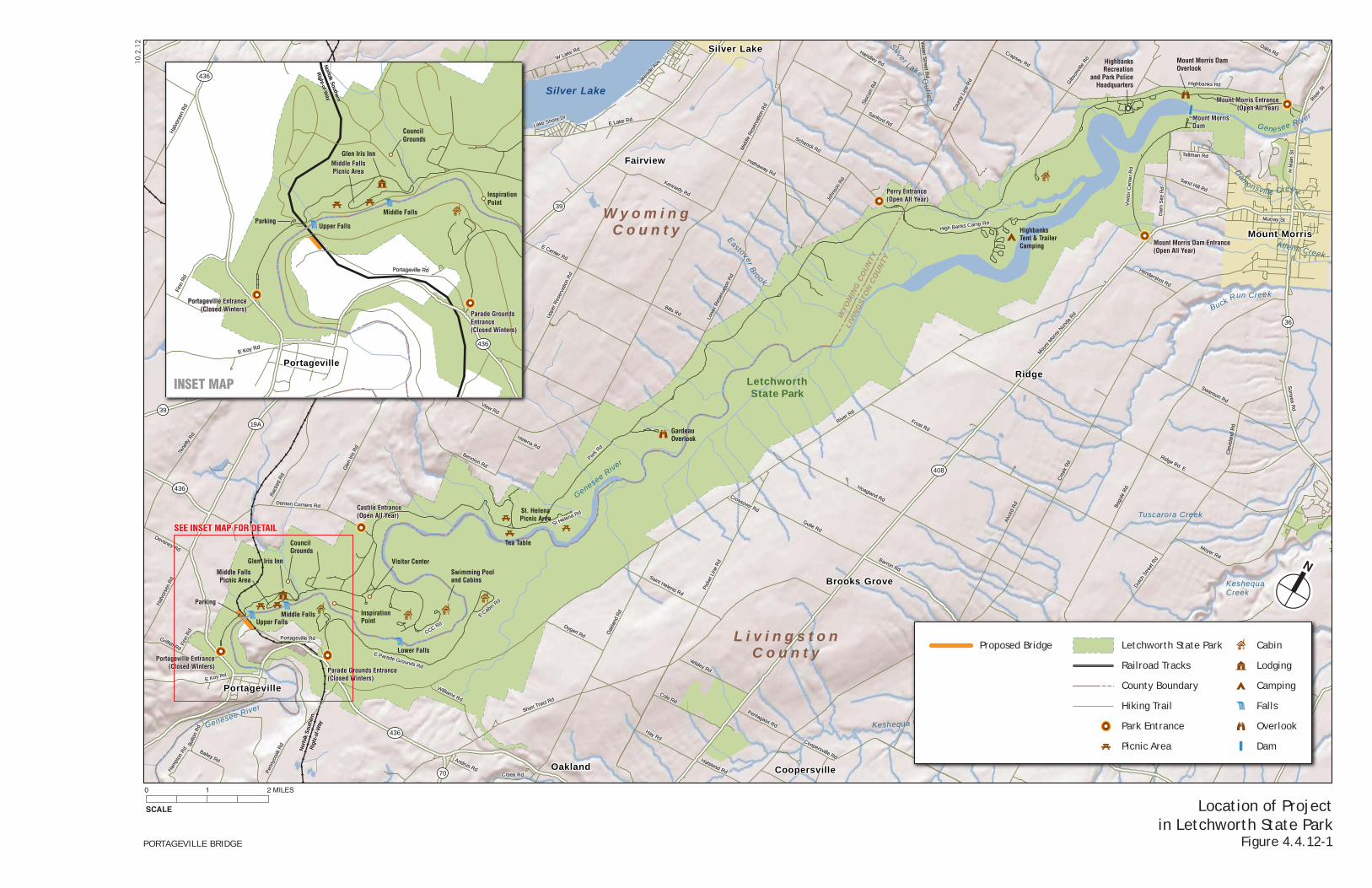
The Project site is located at the southern end of Letchworth State Park, an approximately 14,345-acre park that extends approximately 17 miles along the Genesee River in New York’s Wyoming and Livingston Counties. The park is generally wooded with winding roads and hilly terrain. Within the park, the Genesee River flows from south to north through a deep gorge and over three major waterfalls that are in the southern section of the park: Upper Falls, Middle Falls, and Lower Falls. As a state park that is listed on the State and National Registers of Historic Places, Letchworth State Park is an aesthetic resource of statewide significance. The Genesee River and gorge, waterfalls, and the Portageville Bridge are contributing elements of this aesthetic resource. The park’s scenic features include the forested gorge and river as well as the historic built features in the park—the railroad bridge, the stone walls and staircases along the park’s roads and trails, stone structures (comfort stations, concession stands, etc.) and picnic tables, and a number of historic structures such as the Glen Iris Inn. In recognition of the gorge’s scenic qualities, the Genesee River in Letchworth State Park has been given permanent status by the U.S. Congress as a Study River under the National Wild and Scenic Rivers Act of 1968
4.4: Environmental Conditions Chapter 4.4.12: Parks and Recreational Resources
4.4.12-3
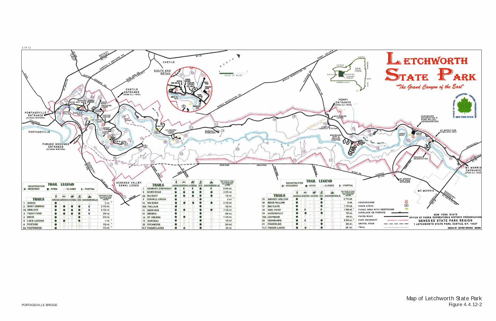
(see Chapter 4.4.3). Figure 4.4.12-1 shows the location of the Project Site in relation to the park, and Figure 4.4.12-2 provides the official park map available from the OPRHP.
The park originated as the estate of William Letchworth, who began purchasing property near the three waterfalls in 1859. This included the house that is now the Glen Iris Inn, as well as surrounding lands. Letchworth continued to purchase and improve the land around his original property until 1907, when he deeded his 1,000-acre estate to New York State and to the stewardship of the American Scenic and Historic Preservation Society (ASHPS) in order to protect the land from future development. The ASHPS ceded the land to the State of New York as part of the state’s new park system in the 1930s. During the 1920s and 30s, the park was expanded through the acquisition of land toward the north and along the east side of the Genesee River and by 1952, most of the land that makes up today’s Letchworth State Park had been purchased or given to the State of New York. The ASHPS made changes to facilitate automobile access, including construction of comfort stations, new parking areas, and expansion of the road system. During the Great Depression, the Civilian Conservation Corps, instituted by President Roosevelt in 1933, also made numerous improvements to the park. Today, Letchworth State Park is under the jurisdiction of the OPRHP.
Letchworth State Park hosts a variety of recreational features and activities, all organized along and around the scenic Genesee River and gorge. These include scenic roads and 66 miles of trails that can be used for hiking, biking, horseback riding, snowmobiling, and cross-country skiing. There are over 270 campsites, 82 cabins, numerous picnic areas, two swimming pools, and the historic Glen Iris Inn, the former home of William Letchworth. Hunting and fishing are allowed, as well as whitewater rafting, kayaking, and hot air ballooning. The park has a number of scenic viewing locations, including the scenic overlooks that are located along the edge of the Genesee River gorge, connected to the park trail system.
The park is characterized by the scenic gorge and by the picturesque stone walls and staircases, stone structures (comfort stations, concession stands, picnic tables), and a number of historic sites and structures such as the Glen Iris Inn and Council Grounds, where historic cabins have been reconstructed.
The main park road, known as Park Road, runs along the western side of the river with turnoffs leading to viewpoints and other park areas. On the eastern side of the river, park roads provide access to the south and north ends of the park, but no continuous park road runs along this side of the river. A number of trails also run along both sides of the river for the length of the park. One pedestrian crossing is available across the Genesee River, via the Footbridge Trail (Trail #6A), which crosses the river on a scenic stone bridge just downstream of the Lower Falls, connecting the Gorge Trail (Trail #1) to the park road on the east side of the southern end of the park (East Park Road).
The south end of the park is notable for the river gorge and three waterfalls, the scenic overlooks, and a concentration of the park’s historic structures and sites. According to OPRHP, it is the most intensely used area of the park and supports the greatest number of visitors. The Portageville Bridge (discussed below) contributes to the scenic character of this end of the park and is depicted on park postcards and memorabilia. The north end of the park has fewer scenic sites of this nature, and is characterized predominantly by the Mt. Morris Dam on the Genesee River. This end of the park also has a large trailer and tent camping area.
South End of Park near Rail Bridge
As shown in Figures 4.4.12-1 and 4.4.12-3, the south end of Letchworth State Park includes a number of park features, including historic sites, trails, and scenic points. On the west side of the river, as noted above, many of the park’s historic sites are clustered in the southern end of the
Ridge
Chace
Oakland
Castile
Fairview
Tuscarora
Silver Lake
Portageville
Mount Morris
Coopersville
Brooks Grove
Silver Springs
39
39
36
70
19A
436
436
408
L i v i n g s t o nC o u n t y
W y o m i n gC o u n t y
WYO
MIN
G C
OUN
TY
LIVI
NGST
ON
COUN
TY
Silver Lake
Buck Run Creek
Silver Lake Outlet
Eastover Brook
Two Mile C
reek
Allens Creek
Damonsville Creek
Genesee River
Keshequa CreekGenesee River
Genesee River
KeshequaCreek
Tuscarora Creek
LetchworthState Park
Silver LakeState Park
Park R
d
Park R
d
River Rd
River Rd
Cre
ek R
d
Cre
ek R
d
Frost Rd
Frost Rd
Beg
ole
Rd
Beg
ole
Rd
Ridge Rd E
Ridge Rd E
Short Tract Rd
Short Tract Rd
E Lake RdE Lake Rd
East Rd
East Rd
Mou
nt M
orris
Nun
da R
d
Mou
nt M
orris
Nun
da R
d
Hoagland Rd
Hoagland Rd
Barron Rd
Barron Rd
Oak
land
Rd
Oak
land
Rd
Mid
dle
Res
erva
tion
Rd
Mid
dle
Res
erva
tion
Rd
W Lake Rd
W Lake Rd
Sonyea R
dS
onyea Rd
Dut
ch S
treet
Rd
Dut
ch S
treet
Rd
Tene
fly R
d
Tene
fly R
d
Swyers Rd
Swyers Rd
Jord
an R
d
Jord
an R
d
Alv
ord
Rd
Alv
ord
Rd
Highbanks RdHighbanks Rd
Sanford Rd
Sanford Rd
Swanson Rd
Swanson Rd
School Rd
School Rd
Hathaway Rd
Hathaway Rd
Guile Rd
Guile Rd
Schenck Rd
Schenck Rd
View Rd
View Rd
Rac
kett
Rd
Rac
kett
Rd
Pic
ket L
ine
Rd
Pic
ket L
ine
Rd
Upp
er R
eser
vatio
n R
d
Upp
er R
eser
vatio
n R
d
Broughton Rd
Broughton Rd
E Center Rd
E Center Rd
Denton Corners RdDenton Corners Rd
Dud
ley
Rd
Dud
ley
Rd
Gib
sonv
ille R
d
Gib
sonv
ille R
d
Gle
n Iri
s R
d
Gle
n Iri
s R
d
Gulley Rd
Gulley Rd
Barber Rd
Barber Rd
Moyer Rd
Moyer Rd
Sci
pio
Rd
Sci
pio
Rd
Low
er R
eser
vatio
n R
d
Low
er R
eser
vatio
n R
d
Cole RdCole Rd
E Koy RdE Koy Rd
Kennedy Rd
Kennedy Rd
Presbyterian RdPresbyterian Rd
Slo
cum
Rd
Slo
cum
Rd
Hay RdHay Rd
Bennion Rd
Bennion Rd
Wea
ver R
d
Wea
ver R
d
Murray StMurray St
Par
k R
d W
Par
k R
d W
Fulle
r Rd
Fulle
r Rd
Pen
nyco
ok R
d
Pen
nyco
ok R
d
Nor
folk
Sou
ther
nR
ight
-of-
Way
Nor
folk
Sou
ther
nR
ight
-of-
Way
Mai
n St
Mai
n St
M C
lark
Rd
M C
lark
Rd
Creveling Rd
Creveling Rd
W Center Rd
W Center Rd
Bol
ton
Rd
Bol
ton
Rd
Bills RdBills Rd
E Parade Grounds Rd
E Parade Grounds RdWildey Rd
Wildey Rd
John
son
Rd
John
son
Rd
S Main StS Main St
Griffith Rd
Griffith Rd
Cle
vela
nd R
dC
leve
land
Rd
Bailey Rd
Bailey Rd
Crapsey Rd
Crapsey Rd
Moffat Rd
Moffat Rd
Hal
vors
en R
d
Hal
vors
en R
d
Wildcat Rd
Wildcat Rd
Vis
itor
Cen
ter
Rd
Vis
itor
Cen
ter
Rd
Saint Helena Rd
Saint Helena Rd
Cou
nty
Line
Rd
Cou
nty
Line
Rd
Dygert Rd
Dygert Rd
Oak
Hill
Rd
Oak
Hill
Rd
Oaks Rd
Oaks Rd
Dam
Site
Rd
Dam
Site
Rd
Williams Rd
Williams Rd
Sand Hill Rd
Sand Hill Rd
Hoe
hand
le R
d
Hoe
hand
le R
d
Portageville RdPortageville Rd
Water S
treet Rd
Water S
treet Rd
River S
t
River S
t
Tallman RdTallman Rd
Pau
line
Rd
Pau
line
RdCoopersville Rd
Coopersville Rd
W Mill St
W Mill St
High Banks Camp RdHigh Banks Camp Rd
N M
ain
St
N M
ain
St
Finn
Rd
Finn
Rd
Lake
side
Ave
Lake
side
Ave
Uni
on C
orne
rs R
d
Uni
on C
orne
rs R
d
Handley Rd
Handley Rd
Devaney Rd
Devaney Rd
Pentagass Rd
Pentagass Rd
Halstead Rd
Halstead Rd
Hendershot Rd
Hendershot Rd
Pin
kney
Rd
Pin
kney
Rd
Lake Shore Dr
Lake Shore Dr
CCC Rd
CCC Rd
Ham
pton
Rd
Ham
pton
Rd
Andrus Rd
Andrus Rd
Liberty StLiberty St
Helena Rd
Helena Rd
Beechw
ood Ave
Beechw
ood Ave
E Cabin R
d
E Cabin R
d
Crossover Rd
Crossover Rd
St Helena Rd
St Helena Rd
Cot
tage
St
Cot
tage
St
Pre
sbyt
eria
n R
d
Pre
sbyt
eria
n R
d
N M
ain
St
N M
ain
St
Creek RdCreek Rd
Sta
te R
oute
19A
Sta
te R
oute
19A
Parking
Castile Entrance(Open All Year)
Perry Entrance(Open All Year)
Mount Morris Dam Entrance(Open All Year)
Mount Morris Entrance(Open All Year)
Portageville Entrance(Closed Winters) Parade Grounds Entrance
(Closed Winters)
GardeauOverlook
HighbanksTent & TrailerCamping
Mount Morris DamOverlook
Mount MorrisDam
HighbanksRecreation
and Park PoliceHeadquarters
St. HelenaPicnic Area
Tea Table
Swimming Pooland Cabins
Lower Falls
Middle FallsUpper Falls
Middle FallsPicnic Area
CouncilGrounds
Glen Iris Inn
InspirationPoint
Visitor Center
PortagevilleE Koy RdE Koy Rd
Hal
vors
en R
d
Hal
vors
en R
d
Portageville RdPortageville Rd
Finn
Rd
Finn
Rd
Portageville Entrance(Closed Winters)
Parade GroundsEntrance(Closed Winters)
Middle Falls
Upper Falls
CouncilGrounds
Glen Iris Inn
Parking
InspirationPoint
436
436
Middle FallsPicnic Area
Norfolk S
outhern
Right-of-W
ayN
orfolk Southern
Right-of-W
ay
10.2
.12
Location of Projectin Letchworth State Park
Figure 4.4.12-1
SCALE
0 1 2 MILES
N
PORTAGEVILLE BRIDGE
SEE INSET MAP FOR DETAILSEE INSET MAP FOR DETAIL
INSET MAP
Letchworth State Park
Railroad Tracks
County Boundary
Hiking Trail
Park Entrance
Picnic Area
Proposed Bridge Cabin
Lodging
Camping
Falls
Overlook
Dam
3.19.12
Map of Letchworth State ParkFigure 4.4.12-2PORTAGEVILLE BRIDGE
3.28
.12
NOT TO SCALENOTE: For Trail Legend See Figure 4.4.12-2
Map of South End ofLetchworth State Park
Figure 4.4.12-3
N
PORTAGEVILLE BRIDGE
Portageville Bridge DEIS PIN 4935.79.101
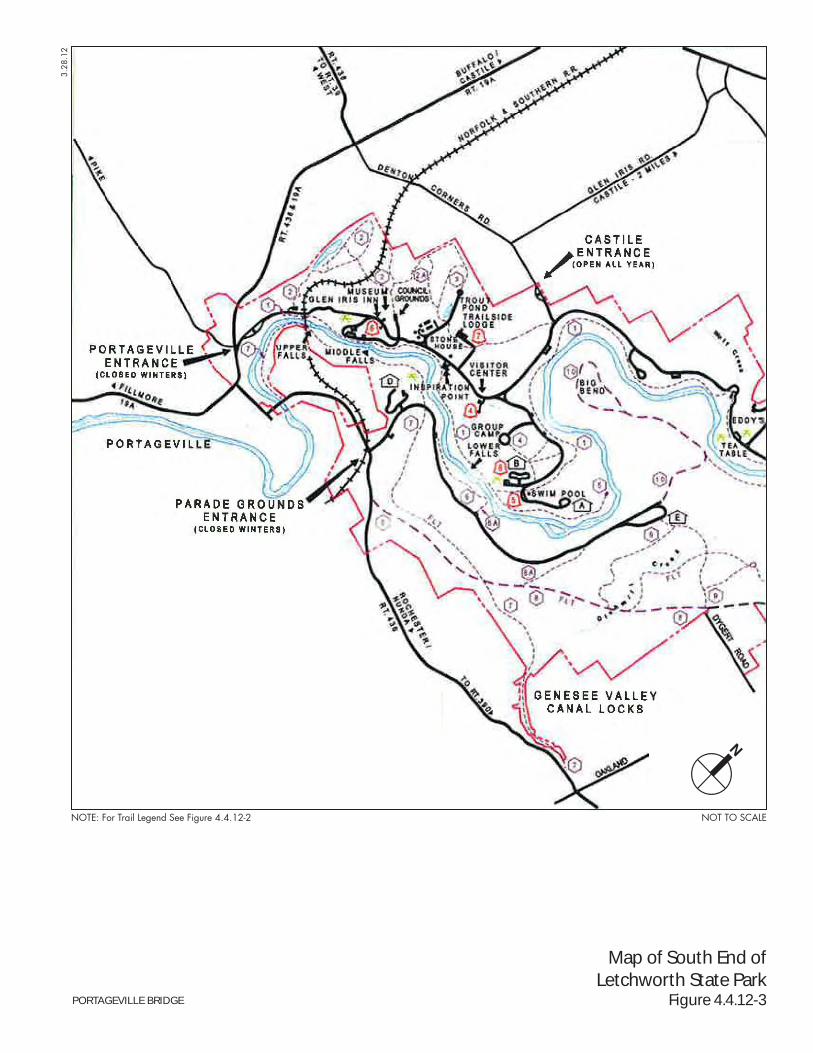
4.4.12-4
park. Park features in the south end of the park near the Portageville Bridge include (but are not limited to) the following features:
Genesee River Gorge and Waterfalls. The Genesee River gorge forms the spine of the park, with park features arranged around the river. In the southern end of the park, the river has three major waterfalls: Upper Falls, located almost beneath the Portageville Bridge; Middle Falls, about ½ mile downstream (to the north); and Lower Falls, about 1¼ mile further downstream from Middle Falls.
Park Road and Park Entrances. Park Road runs north–south along the west side of the Genesee River gorge, for the length of Letchworth State Park, providing access to park features throughout the park. In the south end of the park, Park Road begins at the Portageville Entrance on Route 19A, which is closed in the winter (and is used for part of a snowmobile trail from the Portageville Entrance to the Highbridge Parking Area). The Portageville Entrance is a rustic-style entrance with two lanes for entering traffic and two lanes for exiting traffic. The Castile Entrance from Denton Corners Road provides a year-round entrance to the southern part of the park via Park Road. This entrance is a more utilitarian style wooden booth with one entering lane and one exiting lane. Farther north, Park Road is also accessible via the Perry Entrance and Mt. Morris Entrance.
Highbridge Parking Area. This small parking area is located on the west side of Park Road just south of the Portageville Bridge. It currently serves parkgoers using the southern trailheads for the Mary Jemison Trail and Gorge Trail (discussed below).
Trails. As shown in Figure 4.4.12-2, 28 interconnected trails, totaling some 73 miles, run through the park. All of these trails can be used for hiking, and a number can be used for biking, horseback riding, skiing, and snowmobiling. As noted on Figure 4.4.12-2, sections of these trails along the canyon edge cannot be used in the winter. Three trails are close to the Portageville Bridge:
— Mary Jemison Trail. This trail, Trail #2 on OPRHP’s park map, is a 2.5-mile trail that runs from the Highbridge Parking Area to the Council Grounds site. This trail is used for hiking, biking, horseback riding, skiing, snowmobiling, and archery hunting in the fall as part of the deer management program in the park. For snowmobilers, the Mary Jemison Trail provides a connection from the south (via the Park Road beginning at the Portageville Entrance) to a larger corridor trail (State Corridor Trail 3) to the north. In addition, OPRHP sometimes uses the southern end of the Mary Jemison trail for interpretive programs.
— Gorge Trail (Trail #1). The Gorge Trail extends seven miles along the western edge of the Genesee River gorge from a trailhead near the base of the existing rail bridge to the St. Helena Picnic Area in the middle of the park. Access to this trail is available from a number of points throughout the park. Near the Portageville Bridge, the Gorge Trail begins just south of the bridge across Park Road from the Highbridge Parking Area, and passes beneath the bridge as it heads north along the edge of the gorge.
— Genesee Valley Greenway Trail (Trail #7). On the east side of the river, the Genesee Valley Greenway Trail currently runs 5.75 miles within Letchworth State Park using the abandoned railroad bed of the Pennsylvania Railroad, which had originally been developed as the Genesee Valley Canal. The segment of the Genesee Valley Greenway Trail in Letchworth State Park is part of a longer trail being developed on the canal tow path and rail bed that will extend 90 miles between Rochester and Cuba (at I-86 in the Southern Tier). Most of the Genesee Valley Greenway Trail between Rochester and the hamlet of Portageville, including the segment in Letchworth State Park, is now open. In the park, the trail runs close to the east side of the river and
4.4: Environmental Conditions Chapter 4.4.12: Parks and Recreational Resources
4.4.12-5
passes beneath the Portageville Bridge. However, there is a break in the trail in the park across from Inspiration Point as a result of a slide/slope failure. The detour around this slide area takes trail users out of the park and avoids the portion of the trail that runs along the river gorge beside the Upper and Middle Falls and beneath the Portageville Bridge. The segment of the Genesee Valley Greenway Trail in the park is also part of the Finger Lakes Trail, which extends 26 miles from Mt. Morris at the northern end of the trail to the hamlet of Portageville at the southern end and connects there with the main Finger Lakes Trail system that runs east and west across upstate New York. Outside of the park, other sections of the trail are in the planning or construction stages.1
Upper and Middle Falls Picnic Area. On the west side of the river between the Upper and Middle Falls, a picnic area is located along the west bank of the river, close to the level of the water. It has a large paved parking area, lawns with trees and stone picnic tables, a concession stand and a comfort station. The Gorge Trail runs along the edge of the picnic area close to the river’s edge. At the south end of the picnic area, a path leads to a vista point of the Upper Falls and Portageville Bridge.
Glen Iris Inn and Other Accommodations. The historic Glen Iris Inn is west of and uphill from the Upper and Middle Falls Picnic Area. This mid-19th century structure was originally the home of William Pryor Letchworth and now is a destination in the park that provides lodging and meals. The Glen Iris Inn has a large, grassy lawn lined with trees and a stone terrace overlooking the Genesee River gorge above the Middle Falls. Near the inn, the Pinewood Lodge and three other rental houses also provide accommodations. The inn and lodge are closed during the winter (November through Good Friday).
William Pryor Letchworth Museum. Behind the inn, the William Pryor Letchworth Museum is a museum specializing in the history of the Genesee River Valley. The museum is closed during the winter (November through April).
Council Grounds. West of Park Road and the inn and museum, the Council Grounds site features a Seneca Council House relocated to the site by William Pryor Letchworth, and the burial place of Mary Jemison, an early settler in the area who was captured by and then lived among the Seneca.
Inspiration Point. Continuing north along Park Road from the Glen Iris Inn and Council Grounds, a number of scenic vistas are available. The widest vista is from the park’s Inspiration Point, approximately 1½ miles north of the Portageville Bridge. From this location, the bridge is visible as a small element crossing through the tree canopy above the river gorge.
Scenic Vistas. The park provides a number of scenic overlooks of the gorge and each of the waterfalls. As described in Chapter 4.4.13, “Visual Resources,” the bridge is a scenic feature in views from a number of those locations.
Camping and Cabins. Letchworth State Park includes a number of different overnight accommodations. In addition to the Glen Iris Inn, these include campgrounds and cabins. The closest camping areas and cabins to the Portageville Bridge are approximately 1 mile away near Inspiration Point.
East Side of River. The east side of the river has few developed park features in comparison to the west side. Close to Portageville Bridge, the only developed features are the Genesee Valley Greenway Trail (discussed above) and a cabin area near Inspiration Point. This cabin
1 http://www.fogvg.org, accessed March 2012.
Portageville Bridge DEIS PIN 4935.79.101
4.4.12-6
area is closed during the winter. The cabins are accessible by East Park Road, which runs from the Parade Grounds Entrance off Route 436 (which is also closed during the winter) to the cabin area.
Project Area
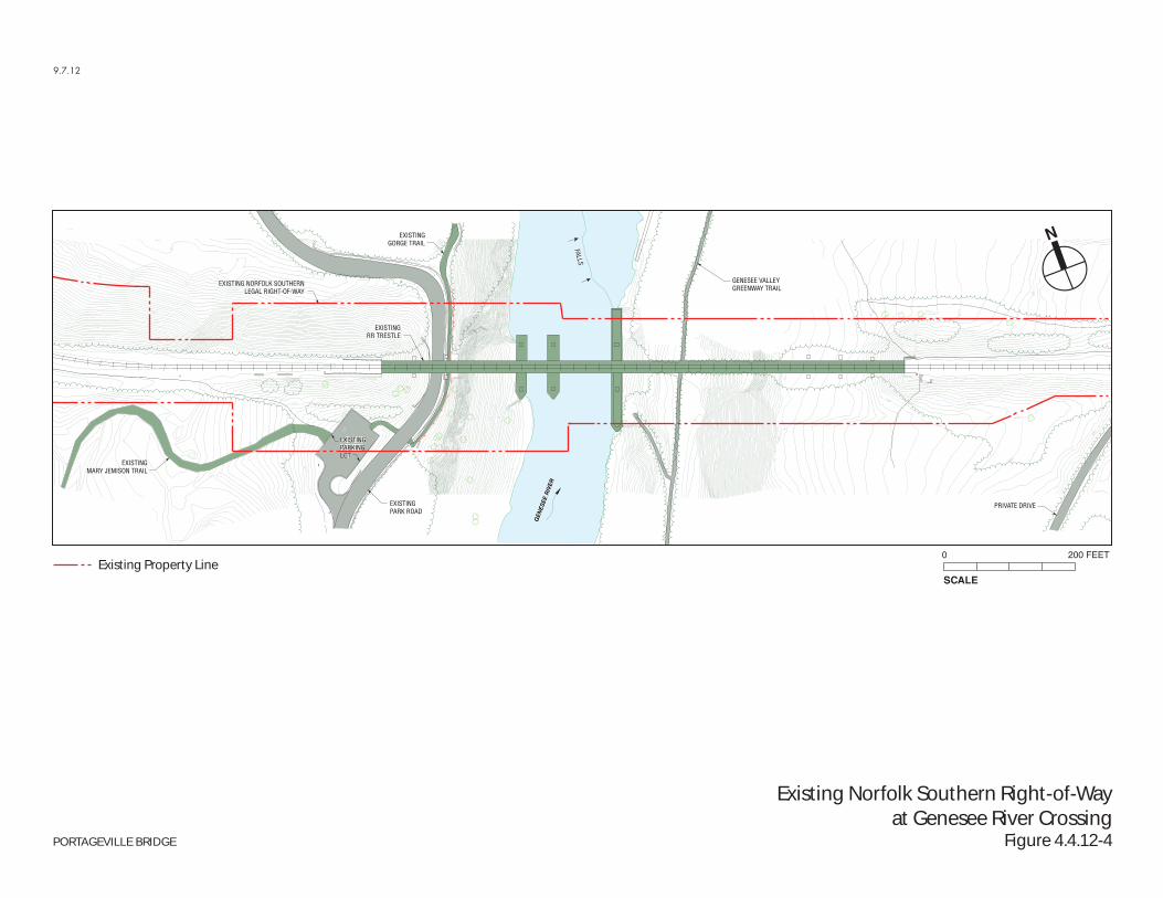
As shown in Figure 4.4.12-1, Norfolk Southern’s Southern Tier rail freight route passes through the southern end of Letchworth State Park. This route is owned by Norfolk Southern and surrounded by the parkland of Letchworth State Park. Norfolk Southern currently operates 12 to 14 trains per day on this route. Norfolk Southern’s right-of-way includes the existing Portageville Bridge over the Genesee River, near the Upper Falls in the southern end of the park (see Figure 4.4.12-4). The railroad right-of-way, including a rail bridge across the Genesee River, has been in the area that is now Letchworth State Park since the early 1850s, well before Letchworth began to purchase the land that later became the park. As discussed in Chapter 4.4.11, “Historic and Cultural Resources,” the original rail bridge was a wooden high bridge. After a fire destroyed the wooden bridge in 1875, the existing iron bridge was constructed in the same location.
The area that would be affected by the Build alternatives (discussed below) includes the bridge and right-of-way to its east and west. The rail right-of-way and bridge are privately owned in fee by the Norfolk Southern Railway Company and are not parkland. The bridge is currently posted with “No Trespassing” signs notifying pedestrians that trespassing on the single-track high bridge is prohibited. However, despite these signs and the obvious hazards, pedestrians trespass on the bridge to gain access to the high vista point it provides over the gorge. As discussed in Chapter 2, “Project Context,” the trespassing is a serious safety consideration for Norfolk Southern operations and requires train operators to cross the bridge at very slow speeds.
On the west side of the river, Norfolk Southern’s existing right-of-way also includes an approximately 250-foot-long segment of Park Road (including the portion that passes beneath the bridge), the southern ends of the Mary Jemison Trail and Gorge Trail (including the portion of the Gorge Trail that passes beneath the bridge), and half of the Highbridge Parking Area that provides access to those two trailheads (see Figure 4.4.12-4). On the east side of the river, Norfolk Southern’s right-of-way includes a portion of the Genesee Valley Greenway Trail (including the segment that passes beneath the bridge).
The Project would also affect a small area of land that is currently parkland but would be acquired by Norfolk Southern to implement the Project. This area includes approximately half of the Highbridge Parking Area, an additional segment of Park Road, and additional segments of the Mary Jemison Trail.
4.4.12-3-2 National and State Heritage Area Programs
The Project site is not identified as a National or State Heritage Area. The closest New York State Heritage Area to the Project site is Rochester's High Falls Heritage Area, a complex of mills, factories, and archaeological sites adjacent to the Genesee River in the City of Rochester. There are three National Heritage Areas in New York State: the Erie Canalway National Heritage Corridor, the Hudson River Valley National Heritage Area, and the Niagara Falls National Heritage Area.
4.4.12-3-3 National Registry of Natural Landmarks
There are no listed nationally significant natural areas within, or adjacent to, the Project area.
EXISTINGMARY JEMISON TRAIL
PRIVATE DRIVE
EXISTINGPARKINGLOT
EXISTINGPARK ROAD
GENESEE VALLEYGREENWAY TRAIL
GEN
ESEE
RIV
ER
EXISTINGRR TRESTLE
EXISTING NORFOLK SOUTHERNLEGAL RIGHT-OF-WAY
EXISTINGGORGE TRAIL
FALLS
9.7.12
Existing Norfolk Southern Right-of-Wayat Genesee River Crossing
Figure 4.4.12-4
SCALE
0 200 FEET
N
PORTAGEVILLE BRIDGE
Existing Property Line
4.4: Environmental Conditions Chapter 4.4.12: Parks and Recreational Resources
4.4.12-7
4.4.12-3-4 Section 6(f) Involvement
The Project would affect a small area of land that is currently parkland but would be acquired by Norfolk Southern to implement the Project. Letchworth State Park has received funding under the LWCFA program. Based on information provided by OPRHP, between 1976 and 2004, 12 grants have been provided to Letchworth State Park through this program (for more information, see Chapter 5, “Section 6(f) Evaluation”). These grants were used for rehabilitation of roads in the park and for general improvements to the park. Because Letchworth State Park has received funding from under the LWCFA program, a Section 6(f) evaluation of the Portageville Bridge Project has been conducted. For more discussion of Section 6(f), see Section 4.4.12-5 below and Chapter 5 of this DEIS.
4.4.12-3-5 Section 1010 Involvement
Letchworth State Park has not received funds under the Urban Park and Recreation Recovery Act. Therefore, the Portageville Bridge Project does not involve the use of land from a park to which Urban Park and Recreation Recovery Program Act funds have been applied and no further evaluation of this program is required.
4.4.12-3-6 Parkland Alienation Principles
The Parkland municipal alienation principles do not apply to this project since Letchworth State Park is under the jurisdiction of OPRHP and the acquisition and management of these lands are governed by the provisions of general applicability in the OPHRP Law §§3.09(1), 3.17, 3.19 and 13.06.
4.4.12-4 EFFECTS ASSESSMENT
4.4.12-4-1 Alternative 1 - No Action Alternative / Maintenance Alternative
With the No Action Alternative, there would be no change to parks and recreational resources compared to existing conditions. The existing bridge would remain; no changes would occur to Park Road or the park trails near the bridge; and the existing Highbridge Parking Area that provides access to the Gorge Trail would be unaffected. However, it is likely that park patrons would continue to trespass on the Portageville Bridge, presenting serious safety concerns.
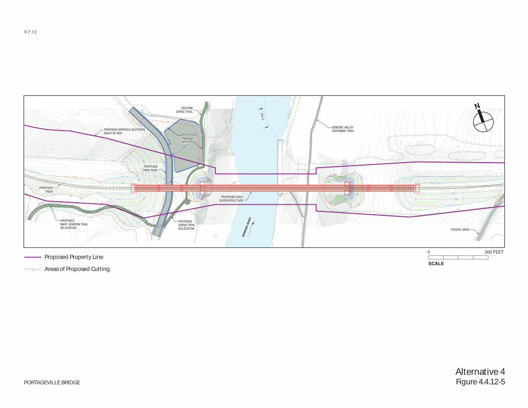
4.4.12-4-2 Alternative 4 - New Bridge on Parallel Alignment / Remove the Existing Bridge
As described in Chapter 3, “Project Alternatives,” Alternative 4 would involve construction of a new bridge parallel, but approximately 75 feet to the south of, the existing bridge and removal of the existing bridge. This would involve shifting the railroad right-of-way southward on either side of the bridge to align with the new bridge. In addition, Park Road within the vicinity of the bridge would be shifted westward to make space for the new bridge structure’s foundations. Alternative 4 would also require relocation of a small parking area from an area south of the existing bridge within Norfolk Southern’s right-of-way to parkland north of the right-of-way.
To accommodate the required shift in the rail alignment under Alternative 4, some parkland would have to be acquired and converted to transportation use, in exchange for an equivalent amount of substitution property. With Alternative 4, Norfolk Southern would acquire approximately 2.8 acres of parkland to be used for the new right-of-way and to provide sufficient area around the bridge for construction, access, and security. The use of this parkland for non-park use represents an adverse impact to the park. Most of this area is wooded land or land in close proximity to the current right-of-way that is not generally accessible to the public or in active use for recreational or park purposes, so its conversion to transportation use would not
Portageville Bridge DEIS PIN 4935.79.101
4.4.12-8
adversely affect the recreational features of Letchworth State Park. To compensate for this loss of parkland, Norfolk Southern would provide land to the park to create replacement parkland. NYSDOT would assign the state’s preferential right to acquire railroad right-of-way that is no longer used for transportation purposes to OPRHP and Norfolk Southern would subsequently transfer land to OPRHP to become part of Letchworth State Park.
On the west side of the river, the Project would alter the park features that encroach within Norfolk Southern’s right-of-way (and also fall within the small area of land to be acquired). As described earlier, Norfolk Southern’s existing right-of-way on the west side of the river includes an approximately 250-foot-long segment of Park Road (including the portion that passes beneath the bridge), the southern ends of the Mary Jemison Trail and Gorge Trail (including the portion of the Gorge Trail that passes beneath the bridge), and half of the Highbridge Parking Area that provides access to those two trailheads. On the east side of the river, no changes would occur to any park features. The specific effects of the Alternative 4 on park features in the southern part of the park would be as follows:
Genesee River Gorge and Waterfalls. With Alternative 4, the Genesee River gorge and the three major falls in the south end of the park would remain unchanged.
Park Road and Park Entrances. The alignment of Park Road near the bridge would be shifted slightly to the west to accommodate the new bridge foundations. With this change, Park Road would continue to pass beneath the Norfolk Southern rail bridge and would continue to run north–south for the length of Letchworth State Park along the west side of the Genesee River. In addition, as part of the Project, the Castile Entrance at Denton Corners Road would be upgraded with a larger, two-lane entrance booth to mitigate for the Project’s effects during construction on park access (for more information on this upgrade, see Chapter 4.5, “Construction Impacts”).
Highbridge Parking Area. Approximately half of the small parking area south of the existing railroad tracks is within property owned by Norfolk Southern, and the other half is on property to be acquired by Norfolk Southern for the Project. To avoid conflicts with the new rail alignment, this parking lot would be relocated to a new site north of the right-of-way, where a larger replacement parking lot would be created as a benefit to park users (see Figure 4.4.12-5). The relocated parking lot would continue to serve parkgoers using the Mary Jemison and Gorge Trails, as it does today.
Trails. With Alternative 4, all park trails would remain. The specific effects on the three trails that are close to the Portageville Bridge would be as follows:
— Mary Jemison Trail. The southern trailhead for the Mary Jemison Trail would be shifted slightly to the south, and would be accessible from the west side of Park Road. With this shift, the trail would retain its existing functionality and recreational usefulness.
— Gorge Trail. The southern trailhead for the Gorge Trail would be shifted slightly to the south and west, to meet the relocated Park Road. The trail would pass beneath the new rail bridge and then return to its original route.
— Genesee Valley Greenway Trail. This trail would continue to pass beneath the rail bridge on the eastern side of the river. No changes to the location of the trail would occur.
Other Park Features. The Project would not change the recreational amenities or overall park experience at other locations in Letchworth State Park, including the Middle and Upper Falls Picnic Area, Glen Iris Inn and other accommodations, William Pryor Letchworth Museum, Council Grounds, Inspiration Point and other scenic vistas, and camping and cabin areas.
PROPOSEDMARY JEMISON TRAILRELOCATION
PROPOSED ARCHSUPERSTRUCTURE
PROPOSEDGORGE TRAILRELOCATION
PROPOSEDTRACK
PRIVATE DRIVE
GENESEE VALLEYGREENWAY TRAIL
GEN
ESEE
RIV
ER
PROPOSEDPARKINGAREA
PROPOSED NORFOLK SOUTHERNRIGHT-OF-WAY
EXISTINGGORGE TRAIL
PROPOSEDPARK ROAD
FALLS
9.7.12
Alternative 4Figure 4.4.12-5
SCALE
0 200 FEET
N
PORTAGEVILLE BRIDGE
Proposed Property Line
Areas of Proposed Cutting
4.4: Environmental Conditions Chapter 4.4.12: Parks and Recreational Resources
4.4.12-9
As discussed in Chapter 4.4.13, “Visual Resources,” removal of the Portageville Bridge would result in an adverse effect in terms of visual resources in the park. The bridge currently contributes to the scenic qualities of the park and is an iconic feature on park memorabilia. The new bridge structure, however, would not interfere with or reduce the public’s enjoyment of the natural features that compose Letchworth State Park, and the removal of the current bridge would enhance views of the natural features of the river and gorge because the existing bridge supports within the river gorge would be removed.
The Project would require that approximately three acres be cleared, to accommodate the new rail alignment and relocated Park Road and parking lot. In areas disturbed by construction and along the former rail right-of-way, new trees and native species would be planted, limiting the disturbance resulting from tree clearing in that area.
Alternative 4 would improve safety conditions for pedestrians in Letchworth State Park by implementing measures to further discourage pedestrians from trespassing on the new rail bridge. As described in Chapter 3, “Project Alternatives,” automatic gates, fencing, or other safety devices would be implemented to enhance trespassing-prevention measures for the railroad right-of-way and new river crossing.
Once the new bridge is in place, freight trains would operate at higher speeds through the park (35 miles per hour rather than 10 miles per hour). This would result in slightly increased noise levels associated with train operations that would be audible in the immediate vicinity of the railroad right-of-way in the park. The area affected would be only a small portion of the park that is immediately adjacent to the proposed new bridge. Consequently, the moderate noise impact would not be considered significant.
Overall, the Project would result in minor changes to park features in the area within the immediate vicinity of the Project site. The small shifts in these park features would not affect their recreational function or adversely affect parkgoers’ experience when using these features. Given the small area affected relative to the total acreage of the 14,350-acre park and the minor changes that are proposed, this change would not affect the overall character or features of the park.
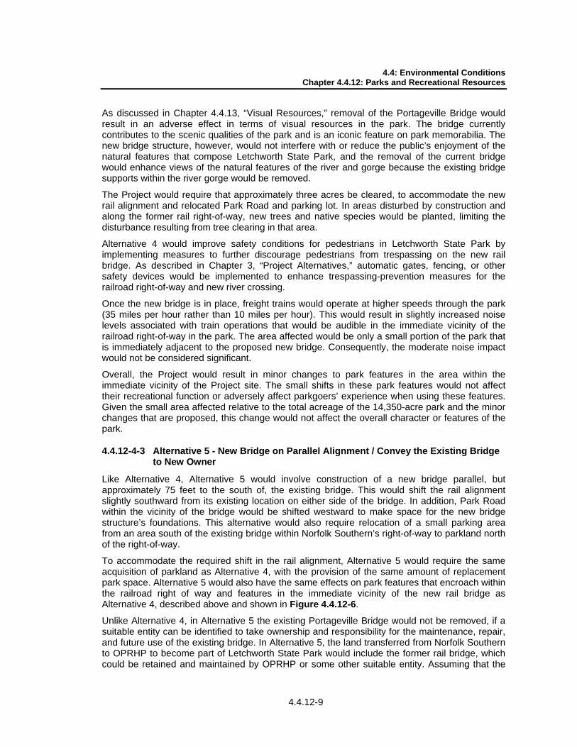
4.4.12-4-3 Alternative 5 - New Bridge on Parallel Alignment / Convey the Existing Bridge to New Owner
Like Alternative 4, Alternative 5 would involve construction of a new bridge parallel, but approximately 75 feet to the south of, the existing bridge. This would shift the rail alignment slightly southward from its existing location on either side of the bridge. In addition, Park Road within the vicinity of the bridge would be shifted westward to make space for the new bridge structure’s foundations. This alternative would also require relocation of a small parking area from an area south of the existing bridge within Norfolk Southern’s right-of-way to parkland north of the right-of-way.
To accommodate the required shift in the rail alignment, Alternative 5 would require the same acquisition of parkland as Alternative 4, with the provision of the same amount of replacement park space. Alternative 5 would also have the same effects on park features that encroach within the railroad right of way and features in the immediate vicinity of the new rail bridge as Alternative 4, described above and shown in Figure 4.4.12-6.
Unlike Alternative 4, in Alternative 5 the existing Portageville Bridge would not be removed, if a suitable entity can be identified to take ownership and responsibility for the maintenance, repair, and future use of the existing bridge. In Alternative 5, the land transferred from Norfolk Southern to OPRHP to become part of Letchworth State Park would include the former rail bridge, which could be retained and maintained by OPRHP or some other suitable entity. Assuming that the
PROPOSEDMARY JEMISON TRAILRELOCATION
PROPOSEDGORGE TRAILRELOCATION
PROPOSEDTRACK
PRIVATE DRIVE
GENESEE VALLEYGREENWAY TRAIL
GEN
ESEE
RIV
ER
PROPOSEDPARKINGAREA
PROPOSED NORFOLK SOUTHERNRIGHT-OF-WAY
EXISTINGGORGE TRAIL
PROPOSEDPARK ROAD
FALLS
9.7.12
Alternative 5Figure 4.4.12-6
SCALE
0 200 FEET
N
PORTAGEVILLE BRIDGE
Proposed Property Line
Areas of Proposed Cutting
Portageville Bridge DEIS PIN 4935.79.101
4.4.12-10
existing bridge and right-of-way would be utilized as recreational resources (such as a pedestrian path), they would change from their present transportation use to a recreational use with Alternative 5. If a suitable new owner could be identified that would maintain the bridge, the addition of a high pedestrian crossing above the gorge would benefit recreational users of Letchworth State Park, by providing safe access to views above the gorge from a new viewpoint.
As described in Chapter 3, “Project Alternatives,” on the west side of the river, the two bridge spans west of the gorge would have to be removed in Alternative 5 to accommodate the required shift to Park Road. Therefore, the new owner would have to modify the bridge on the west side of the river if pedestrian access is to be provided from this side of the river, such as by creating a new staircase at the remaining bridge pier at the top of the gorge.
Because it would retain the existing bridge, Alternative 5 would result in a significant adverse impact on visual resources in the park that would not occur with Alternative 4. In this alternative, the presence of two bridges across the gorge at the top of the Upper Falls—the existing bridge and the new bridge beside it—would result in significant adverse effects to the aesthetic character of Letchworth State Park and the setting of the existing bridge. As described in Chapter 4.4.13, “Visual Resources,” the visual impact assessment concluded that, from each of the viewpoints studied, the view with both bridges present resulted in a greater degree of negative visual impact than the view with one new bridge. The two-bridge views contained the most visual contrast compared to the natural setting of the gorge. Further, as detailed in Chapter 4.1, “Process, Agency Coordination, and Public Participation,” as part of the Project’s public outreach program, NYSDOT formed a Citizens’ Advisory Committee (CAC) consisting of park patrons and local representatives to provide comments and input on the proposed Project. In comments on the alternatives study conducted for the Project, CAC members expressed dissatisfaction with the two-bridge views.
In other respects, the effects of Alternative 5 on Letchworth State Park would be the same as those of Alternative 4, described above. Overall, the Project would result in minor changes to park features in the area within the immediate vicinity of the Project site. The small shifts in these park features would not affect their recreational function or adversely affect parkgoers’ experience when using these features. Given the small area affected relative to the total acreage of the 14,350-acre park and the minor changes that are proposed, this change would not affect the overall character or features of the park.
4.4.12-5 SECTION 6(f) INVOLVEMENT
The Portageville Bridge Project under either Alternative 4 or 5 would permanently convert approximately 2.8 acres of parkland that is currently part of Letchworth State Park into a railroad right-of-way, and would temporarily occupy an additional 0.8 acres of parkland during construction for longer than six months. Since Letchworth State Park has received funding under the LWCFA, the 3.6 acres of land that would be converted either permanently or for more than six months is subject to the requirements of Section 6(f).
Written approval from the National Park Service is required for the conversion of the parkland to railroad use. As required for parks that have received funding under the LWCFA, as discussed above, Norfolk Southern will arrange for land to be conveyed to the park that is of at least equivalent fair market value and at least equivalent recreational usefulness as the land to be converted for the rail right-of-way. NYSDOT will work with OPRHP to confirm that the replacement land is an appropriate replacement under Section 6(f), and OPRHP will review the conversion proposal documentation and submit it to the National Park Service. A discussion of the conversion proposal is included in Chapter 5, “Section 6(f) Evaluation.”
4.4: Environmental Conditions Chapter 4.4.12: Parks and Recreational Resources
4.4.12-11
4.4.12-6 SUMMARY OF AVOIDANCE, MINIMIZATION, AND MITIGATION
As discussed in Chapter 3, “Project Alternatives,” and Appendix B, “Alternatives Screening Analysis,” a range of different alternatives were evaluated to repair or replace Norfolk Southern’s Genesee River crossing on the Southern Tier route. Several of the alternatives analyzed would have removed the freight rail route from Letchworth State Park and therefore would have avoided any need to acquire parkland or to remove the existing Portageville Bridge (assuming that a new entity could be identified to take ownership and responsibility for the bridge). However, these alternatives were found not to meet the Project’s purpose and need or presented engineering, operational, and environmental concerns that made them imprudent, and each was therefore rejected.
The alternatives that were identified in the screening analysis as meeting the Project’s purpose and need and not presenting concerns that made them imprudent are the Project’s Build alternatives, Alternatives 4 and 5. These alternatives have been developed and designed to minimize to the greatest extent practicable the need to acquire parkland. The new bridge would be in the immediate vicinity of the existing bridge, where the rail right-of-way is already located, thereby minimizing the use of parkland for railroad right-of-way. Minor shifts to two park trails, a parking area, and Park Road would be required, but these shifts are not significant and have also been designed to minimize impacts to the extent practicable. The small shifts in these park features would not affect their recreational function or adversely affect parkgoers’ experience when using these features.
As discussed in Chapter 4.5, “Construction Impacts,” to mitigate for impacts during construction related to the use of Park Road, the Project would improve the Castile Entrance to the park by upgrading the entrance booth there.
Under either Alternative 4 or Alternative 5, approximately 2.8 acres of parkland would be converted to railroad use for the Project. Norfolk Southern would transfer an equivalent amount of land located in close proximity to the converted land to OPRHP to become part of Letchworth State Park, subject to the concurrence of the OPRHP and the approval by the National Park Service in accordance with the requirements of Section 6(f). Therefore, there would be no substantial change in the amount of parkland with either alternative.
During Project planning and continuing into final design and construction, Norfolk Southern will continue to coordinate with OPRHP and NPS, as appropriate, regarding impacts to Letchworth State Park and design features to minimize those impacts. More information on agency coordination is provided in Chapter 4.1, “Process, Agency Coordination, and Public Participation.”