Embed Size (px)
Citation preview
Chapter 4The Benue Trough
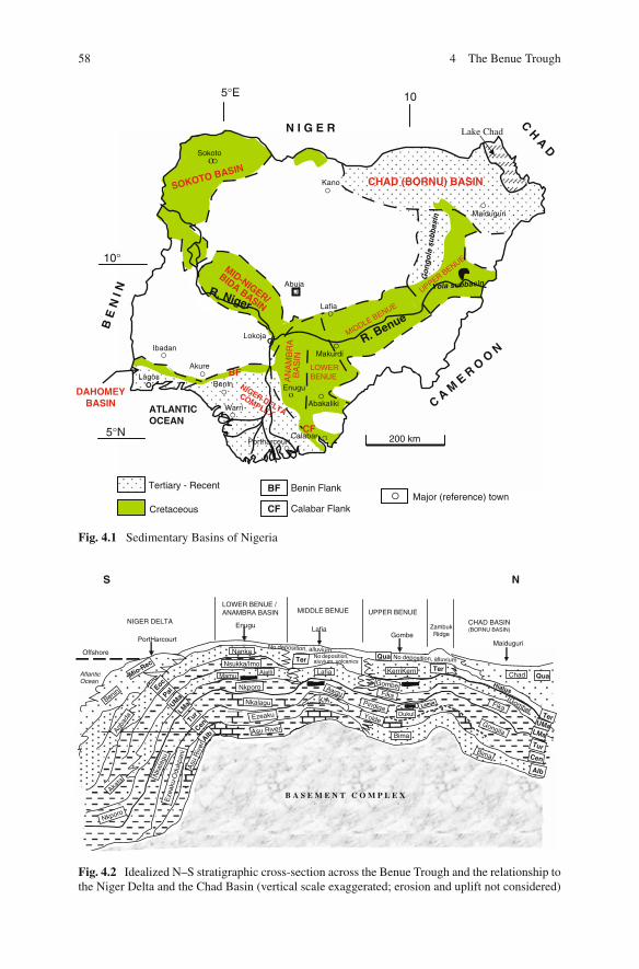
The Benue Trough of Nigeria is a rift basin in central West Africa that extendsNNE–SSW for about 800 km in length and 150 km in width. The southern limit isthe northern boundary of the Niger Delta, while the northern limit is the south-ern boundary of the Chad Basin (Fig. 4.1). The trough contains up to 6,000 mof Cretaceous – Tertiary sediments of which those predating the mid-Santonianhave been compressionally folded, faulted, and uplifted in several places. Com-pressional folding during the mid-Santonian tectonic episode affected the wholeof the Benue Trough and was quite intense, producing over 100 anticlines and syn-clines (Benkhelil, 1989). Major such deformational structures include the Abakalikianticlinorium and the Afikpo syncline in the Lower Benue, the Giza anticline andthe Obi syncline in the Middle Benue, and the Lamurde anticline and the Dadiyasyncline in the Upper Benue Trough.
Following mid-Santonian tectonism and magmatism, depositional axis in theBenue Trough was displaced westward resulting in subsidence of the AnambraBasin. The Anambra Basin, therefore, is a part of the Lower Benue Trough contain-ing post-deformational sediments of Campanian-Maastrichtian to Eocene ages. It islogical to include the Anambra Basin in the Benue Trough, being a related structurethat developed after the compressional stage (Akande and Erdtmann, 1998).
The Benue Trough is arbitrarily subdivided into a lower, middle and upper por-tion (Figs. 4.1, 4.2, 4.3, and 4.4). No concrete line of subdivision can be drawnto demarcate the individual portions, but major localities (towns/settlements) thatconstitute the depocentres of the different portions have been well documented(Petters, 1982; Nwajide, 1990; Idowu and Ekweozor, 1993; Obaje et al., 1999).The depocentres of the Lower Benue Trough comprise mainly the areas aroundNkalagu and Abakaliki, while those of the Anambra Basin centre around Enugu,Awka and Okigwe. The Middle Benue Trough comprises the areas from Makurdithrough Yandev, Lafia, Obi, Jangwa to Wukari. In the Upper Benue Trough, thedepocenters comprise Pindiga, Gombe, Nafada, Ashaka (in the Gongola Arm) andBambam, Tula, Jessu, Lakun, and Numan in the Yola Arm.
N.G. Obaje, Geology and Mineral Resources of Nigeria, Lecture Notesin Earth Sciences 120, DOI 10.1007/978-3-540-92685-6 5,C© Springer-Verlag Berlin Heidelberg 2009
57
58 4 The Benue Trough
Kano
Abuja
Lafia
o
Ibadan
LagosAkure
Benin
Warri
PortharcourtCalabar
Enugu
Abakaliki
Maiduguri
oSokoto
ATLANTICOCEAN
Lake Chad
MID-NIGER/
BIDA BASIN
CHAD (BORNU) BASIN
R. Benue
R. Niger
NIGER DELTA
COMPLEXC A
M E
R O
O N
B E
N I
NN I G E R C H A D
BF
CF200 km
SOKOTO BASIN
LOWERBENUE
MIDDLE BENUE
UPPER BENUE
Makurdi
Go
ng
ola
subb
asin
Yola subbasin
5°N
10°
5°E 10
BF
CF
Tertiary - Recent
Cretaceous
Benin Flank
Calabar FlankMajor (reference) town
DAHOMEYBASIN
Lokoja
AN
AM
BR
A
BA
SIN
Fig. 4.1 Sedimentary Basins of Nigeria
K/A
B A S E M E N T C O M P L E X
Alb
Cen
Tur
LMa
UMa
Ter
QuaTer
Ter
Mio-Rec
EocPal
UMa
LMa
TurCen
Alb
Qua
Asu River
Asu
Riv
er
Ezeaku
Eze
aku-
Odu
kpan
i
Bima
Bima
Yolde
Awgu
LOWER BENUE /ANAMBRA BASIN MIDDLE BENUE UPPER BENUE
ZambukRidge
CHAD BASIN(BORNU BASIN)
NIGER DELTA
Offshore
AtlanticOcean
Pindiga
Gongila
Dukul
Lafia
Fika
Akata
Mamu
Fika
ChadGombe
Gombe
KerriKerri
Nkporo
Nkalagu
Nka
lagu
Nkporo
Nsukka/Imo
Agba
da
Benin
Nanka
S N
No deposition,aluvium, volcanics
Hiatus
No deposition, alluvium
PortHarcourt
Enugu LafiaGombe
Maiduguri
No deposition, alluvium
Lamja
Ajalli
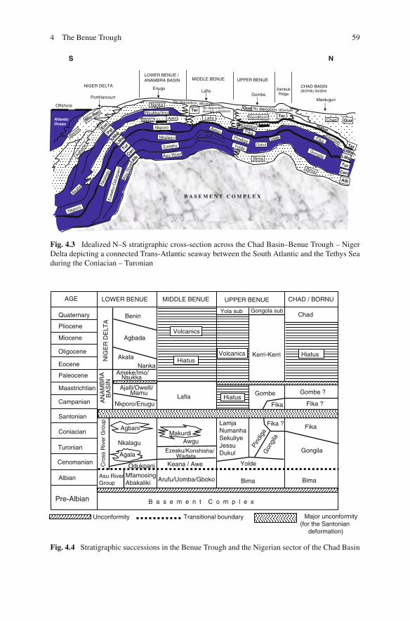
Fig. 4.2 Idealized N–S stratigraphic cross-section across the Benue Trough and the relationship tothe Niger Delta and the Chad Basin (vertical scale exaggerated; erosion and uplift not considered)
4 The Benue Trough 59
K/A
B A S E M E N T C O M P L E X
Alb
Cen
Tur
LMa
UMa
Ter
QuaTer
Ter
Mio-Rec
EocPal
UMa
LMa
TurCen
Alb
Qua
Asu River
Asu
Riv
er
Ezeaku
Eze
aku-
Odu
kpan
i
Bima
Bima
Yolde
Awgu
LOWER BENUE /ANAMBRA BASIN MIDDLE BENUE UPPER BENUE
ZambukRidge
CHAD BASIN(BORNU BASIN)
NIGER DELTA
Offshore
AtlanticOcean
Pindiga
Gongila
Dukul
Lafia
Fika
Akata
Mamu
Fika
ChadGombe
Gombe
KerriKerri
Nkporo
Nkalagu
Nka
lagu
Nkporo
Nsukka/Imo
Agba
da
Benin
Nanka
S N
No deposition,aluvium, volcanics
Hiatus
No deposition, alluvium
PortHarcourt
EnuguLafia
GombeMaiduguri
No deposition, alluvium
Lamja
Ajalli
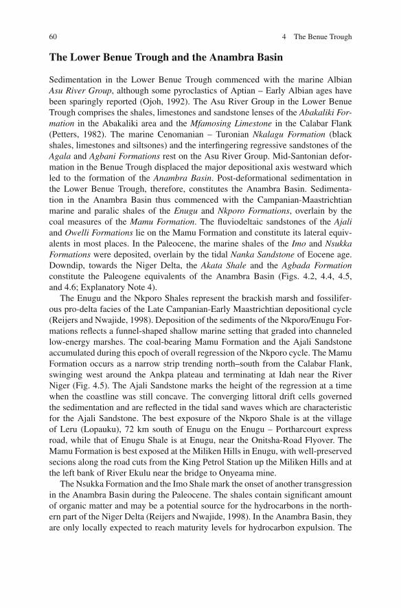
Fig. 4.3 Idealized N–S stratigraphic cross-section across the Chad Basin–Benue Trough – NigerDelta depicting a connected Trans-Atlantic seaway between the South Atlantic and the Tethys Seaduring the Coniacian – Turonian
Pre-Albian
Albian
Cenomanian
Turonian
Coniacian
Santonian
Campanian
Maastrichtian
Paleocene
Eocene
Oligocene
Miocene
Pliocene
Quaternary
Agala
Agbani
Yolde
Gon
gila
Pind
iga
Fika ? Fika
Gombe
Fika
Gongila
Bima Bima
Gombe ?
Fika ?
Chad
HiatusKerri-Kerri
Yola sub Gongola sub
LamjaNumanhaSekuliyeJessuDukul
Hiatus
Volcanics
Arufu/Uomba/Gboko
Keana / Awe
Ezeaku/Konshisha/Wadata
MakurdiAwgu
Lafia
Volcanics
AGE LOWER BENUE MIDDLE BENUE UPPER BENUE CHAD / BORNU
MfamosingAbakaliki
Odukpani
Nkalagu
Asu RiverGroup
Cro
ss R
iver
Gro
upA
NA
MB
RA
BA
SIN
NI G
ER
DE
LTA
Nkporo/Enugu
Ajalli/Owelli/Mamu
Ameke/Imo/Nsukka
AkataNanka
Agbada
Benin
B a s e m e n t C o m p l e x
Unconformity Transitional boundary Major unconformity(for the Santonian
deformation)
HiatusHiatus
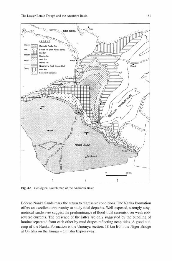
Fig. 4.4 Stratigraphic successions in the Benue Trough and the Nigerian sector of the Chad Basin
60 4 The Benue Trough
The Lower Benue Trough and the Anambra Basin
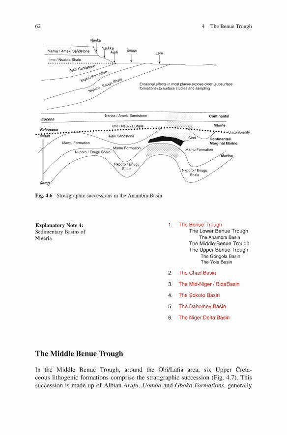
Sedimentation in the Lower Benue Trough commenced with the marine AlbianAsu River Group, although some pyroclastics of Aptian – Early Albian ages havebeen sparingly reported (Ojoh, 1992). The Asu River Group in the Lower BenueTrough comprises the shales, limestones and sandstone lenses of the Abakaliki For-mation in the Abakaliki area and the Mfamosing Limestone in the Calabar Flank(Petters, 1982). The marine Cenomanian – Turonian Nkalagu Formation (blackshales, limestones and siltsones) and the interfingering regressive sandstones of theAgala and Agbani Formations rest on the Asu River Group. Mid-Santonian defor-mation in the Benue Trough displaced the major depositional axis westward whichled to the formation of the Anambra Basin. Post-deformational sedimentation inthe Lower Benue Trough, therefore, constitutes the Anambra Basin. Sedimenta-tion in the Anambra Basin thus commenced with the Campanian-Maastrichtianmarine and paralic shales of the Enugu and Nkporo Formations, overlain by thecoal measures of the Mamu Formation. The fluviodeltaic sandstones of the Ajaliand Owelli Formations lie on the Mamu Formation and constitute its lateral equiv-alents in most places. In the Paleocene, the marine shales of the Imo and NsukkaFormations were deposited, overlain by the tidal Nanka Sandstone of Eocene age.Downdip, towards the Niger Delta, the Akata Shale and the Agbada Formationconstitute the Paleogene equivalents of the Anambra Basin (Figs. 4.2, 4.4, 4.5,and 4.6; Explanatory Note 4).
The Enugu and the Nkporo Shales represent the brackish marsh and fossilifer-ous pro-delta facies of the Late Campanian-Early Maastrichtian depositional cycle(Reijers and Nwajide, 1998). Deposition of the sediments of the Nkporo/Enugu For-mations reflects a funnel-shaped shallow marine setting that graded into channeledlow-energy marshes. The coal-bearing Mamu Formation and the Ajali Sandstoneaccumulated during this epoch of overall regression of the Nkporo cycle. The MamuFormation occurs as a narrow strip trending north–south from the Calabar Flank,swinging west around the Ankpa plateau and terminating at Idah near the RiverNiger (Fig. 4.5). The Ajali Sandstone marks the height of the regression at a timewhen the coastline was still concave. The converging littoral drift cells governedthe sedimentation and are reflected in the tidal sand waves which are characteristicfor the Ajali Sandstone. The best exposure of the Nkporo Shale is at the villageof Leru (Lopauku), 72 km south of Enugu on the Enugu – Portharcourt expressroad, while that of Enugu Shale is at Enugu, near the Onitsha-Road Flyover. TheMamu Formation is best exposed at the Miliken Hills in Enugu, with well-preservedsecions along the road cuts from the King Petrol Station up the Miliken Hills and atthe left bank of River Ekulu near the bridge to Onyeama mine.
The Nsukka Formation and the Imo Shale mark the onset of another transgressionin the Anambra Basin during the Paleocene. The shales contain significant amountof organic matter and may be a potential source for the hydrocarbons in the north-ern part of the Niger Delta (Reijers and Nwajide, 1998). In the Anambra Basin, theyare only locally expected to reach maturity levels for hydrocarbon expulsion. The
The Lower Benue Trough and the Anambra Basin 61
Fig. 4.5 Geological sketch map of the Anambra Basin
Eocene Nanka Sands mark the return to regressive conditions. The Nanka Formationoffers an excellent opportunity to study tidal deposits. Well-exposed, strongly assy-metrical sandwaves suggest the predominance of flood-tidal currents over weak ebb-reverse currents. The presence of the latter are only suggested by the bundling oflamine separated from each other by mud drapes reflecting neap tides. A good out-crop of the Nanka Formation is the Umunya section, 18 km from the Niger Bridgeat Onitsha on the Enugu – Onitsha Expressway.
62 4 The Benue Trough
Nkporo / EnuguShale
Mamu Formation
Mamu FormationNkporo / Enugu Shale
Nkporo / EnuguShale
Ajalli Sandstone
Imo / Nsukka Shale
Nanka / Ameki Sandstone
Mamu Formation
Maast
Camp
Paleocene
Eocene
Nkporo / Enugu ShaleMamu FormationAjalli Sandstone
Nanka / Ameki Sandstone
Imo / Nsukka Shale
Unconformity
Erosional effects in most places expose older (subsurfaceformations) to surface studies and sampling
LeruEnuguAjalli
Nsukka
Nanka
Marine
Marine
Continental
Continental/Marginal Marine
Coal
Fig. 4.6 Stratigraphic successions in the Anambra Basin
1. The Benue TroughThe Lower Benue Trough
The Anambra BasinThe Middle Benue TroughThe Upper Benue Trough
The Gongola BasinThe Yola Basin
2. The Chad Basin
3. The Mid-Niger / BidaBasin
4. The Sokoto Basin
5. The Dahomey Basin
6. The Niger Delta Basin
Explanatory Note 4:Sedimentary Basins ofNigeria
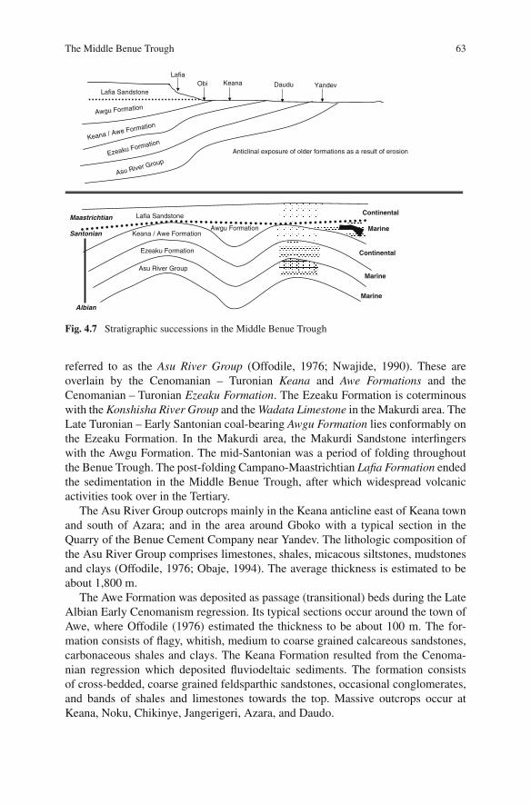
The Middle Benue Trough
In the Middle Benue Trough, around the Obi/Lafia area, six Upper Creta-ceous lithogenic formations comprise the stratigraphic succession (Fig. 4.7). Thissuccession is made up of Albian Arufu, Uomba and Gboko Formations, generally
The Middle Benue Trough 63
Anticlinal exposure of older formations as a result of erosion
Asu River Group
Ezeaku Formation
Keana / Awe FormationAwgu Formation
Lafia Sandstone
Asu River GroupEzeaku Formation
Keana / Awe Formation
Awgu Formation
Lafia Sandstone
Albian
Santonian
Maastrichtian
LafiaObi Keana Daudu Yandev
Marine
Marine
Continental
Marine
Continental
Fig. 4.7 Stratigraphic successions in the Middle Benue Trough
referred to as the Asu River Group (Offodile, 1976; Nwajide, 1990). These areoverlain by the Cenomanian – Turonian Keana and Awe Formations and theCenomanian – Turonian Ezeaku Formation. The Ezeaku Formation is coterminouswith the Konshisha River Group and the Wadata Limestone in the Makurdi area. TheLate Turonian – Early Santonian coal-bearing Awgu Formation lies conformably onthe Ezeaku Formation. In the Makurdi area, the Makurdi Sandstone interfingerswith the Awgu Formation. The mid-Santonian was a period of folding throughoutthe Benue Trough. The post-folding Campano-Maastrichtian Lafia Formation endedthe sedimentation in the Middle Benue Trough, after which widespread volcanicactivities took over in the Tertiary.
The Asu River Group outcrops mainly in the Keana anticline east of Keana townand south of Azara; and in the area around Gboko with a typical section in theQuarry of the Benue Cement Company near Yandev. The lithologic composition ofthe Asu River Group comprises limestones, shales, micacous siltstones, mudstonesand clays (Offodile, 1976; Obaje, 1994). The average thickness is estimated to beabout 1,800 m.
The Awe Formation was deposited as passage (transitional) beds during the LateAlbian Early Cenomanism regression. Its typical sections occur around the town ofAwe, where Offodile (1976) estimated the thickness to be about 100 m. The for-mation consists of flagy, whitish, medium to coarse grained calcareous sandstones,carbonaceous shales and clays. The Keana Formation resulted from the Cenoma-nian regression which deposited fluviodeltaic sediments. The formation consistsof cross-bedded, coarse grained feldsparthic sandstones, occasional conglomerates,and bands of shales and limestones towards the top. Massive outcrops occur atKeana, Noku, Chikinye, Jangerigeri, Azara, and Daudo.
64 4 The Benue Trough
The deposition of the Ezeaku Formation is attributed to the beginning of marinetransgression in the Late Cenomanian. The sediments are made up mainly of cal-careous shales, micaceous fine to medium friable sandstones and beds of limestoneswhich are in places shelly. The deposition took place in a presumably shallowmarine coastal environment. Outcrops of the Ezeaku Formation include those atOrtesh, about 4 km east of the village of Jangerigeri, where the sediments are com-posed mainly of shelly limestones (almost entirely of oystr shell). In the bank ofRiver Tokura, about 20 km east of Keana town, on the Chikinye – Awe road, a typ-ical section of the Ezeaku Formation occurs, consisting mainly of intercalations ofshelly limestones and black shales, with brownish fine to coarse grained feldsparticsandstones at the top.
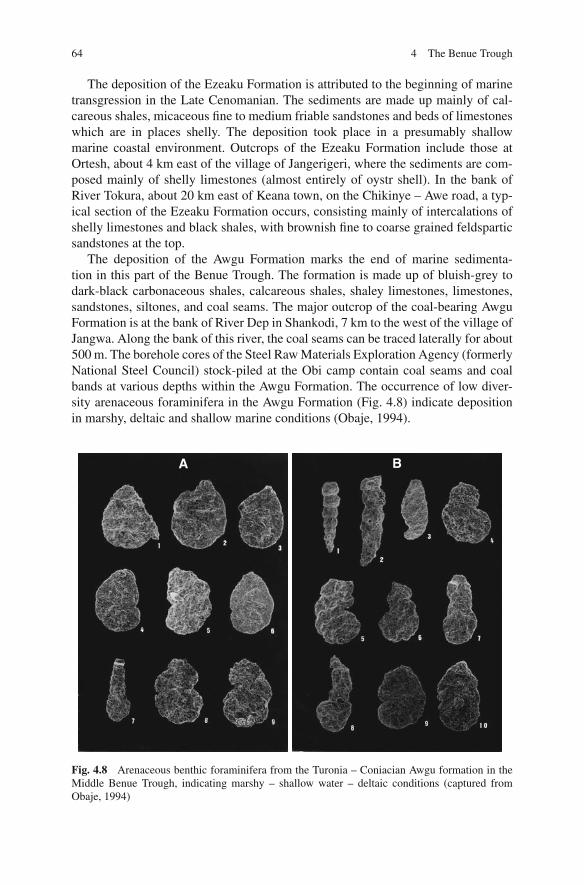
The deposition of the Awgu Formation marks the end of marine sedimenta-tion in this part of the Benue Trough. The formation is made up of bluish-grey todark-black carbonaceous shales, calcareous shales, shaley limestones, limestones,sandstones, siltones, and coal seams. The major outcrop of the coal-bearing AwguFormation is at the bank of River Dep in Shankodi, 7 km to the west of the village ofJangwa. Along the bank of this river, the coal seams can be traced laterally for about500 m. The borehole cores of the Steel Raw Materials Exploration Agency (formerlyNational Steel Council) stock-piled at the Obi camp contain coal seams and coalbands at various depths within the Awgu Formation. The occurrence of low diver-sity arenaceous foraminifera in the Awgu Formation (Fig. 4.8) indicate depositionin marshy, deltaic and shallow marine conditions (Obaje, 1994).
A B
Fig. 4.8 Arenaceous benthic foraminifera from the Turonia – Coniacian Awgu formation in theMiddle Benue Trough, indicating marshy – shallow water – deltaic conditions (captured fromObaje, 1994)
The Upper Benue Trough 65
The Lafia Formation is the youngest formation in this area. The formationwas deposited under continental condition (fluviatile) in the Maastrichtian and liesunconformably on the Awgu Formation. It is lithologically characterized by ferrug-inized sandstones, red, loose sands, flaggy mudstones, clays and claystones. Out-crops and sections of the Lafia Formation occur in and around the town of Lafia,and along the bank of River Amba on the Lafia – Doma road.
The Upper Benue Trough
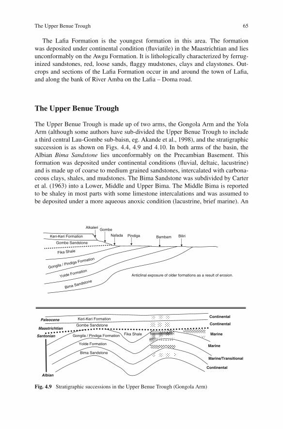
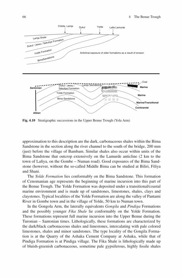
The Upper Benue Trough is made up of two arms, the Gongola Arm and the YolaArm (although some authors have sub-divided the Upper Benue Trough to includea third central Lau-Gombe sub-baisn, eg. Akande et al., 1998), and the stratigraphicsuccession is as shown on Figs. 4.4, 4.9 and 4.10. In both arms of the basin, theAlbian Bima Sandstone lies unconformably on the Precambian Basement. Thisformation was deposited under continental conditions (fluvial, deltaic, lacustrine)and is made up of coarse to medium grained sandstones, intercalated with carbona-ceous clays, shales, and mudstones. The Bima Sandstone was subdivided by Carteret al. (1963) into a Lower, Middle and Upper Bima. The Middle Bima is reportedto be shaley in most parts with some limestone intercalations and was assumed tobe deposited under a more aqueous anoxic condition (lacustrine, brief marine). An
Anticlinal exposure of older formations as a result of erosion.
Bima Sandstone
Yolde Formation
Gongila / Pindiga Formation Fika Shale
Gombe Sandstone
Bima SandstoneYolde Formation
Gongila / Pindiga Formation
Fika Shale
Gombe Sandstone
Albian
Santonian
Maastrichtian
Keri-Keri FormationPaleocene
Keri-Keri Formation BiliriBambamPindigaNafada
GombeAlkaleri
Continental
Marine/Transitional
Marine
Marine
Continental
Continental
Fig. 4.9 Stratigraphic successions in the Upper Benue Trough (Gongola Arm)
66 4 The Benue Trough
Anticlinal exposure of older formations as a result of erosion
Bima Sandstone
Yolde Formation
Dukul / Jessu / Sekuliye Formation
Lamja Samdstone
BimaSandstoneYolde Formation
Dukul / Jessu / Sekuliye FormationLamja Shale
Albian
Santonian
Chikila, Lamja Dukul Yolde Lafia Lamurde
Continental
Marine/Transitional
Marine
Marine
Coal
Fig. 4.10 Stratigraphic successions in the Upper Benue Trough (Yola Arm)
approximation to this description are the dark, carbonaceous shales within the BimaSandstone in the section along the river channel to the south of the bridge, 200 mm(just) before the village of Bambam. Similar shales also occur within units of theBima Sandstone that outcrop extensively on the Lamurde anticline (2 km to thetown of Lafiya, on the Gombe – Numan road). Good exposures of the Bima Sand-stone (however, without the so-called Middle Bima can be studied at Biliri, Filiyaand Shani.
The Yolde Formation lies conformably on the Bima Sandstone. This formationof Cenomanian age represents the beginning of marine incursion into this part ofthe Benue Trough. The Yolde Formation was deposited under a transitional/coastalmarine environment and is made up of sandstones, limestones, shales, clays andclaystones. Typical localities of the Yolde Formation are along the valley of PantamiRiver in Gombe town and in the village of Yolde, 50 km to Numan town.
In the Gongola Arm, the laterally equivalents Gongila and Pindiga Formationsand the possibly younger Fika Shale lie conformably on the Yolde Formation.These formations represent full marine incursion into the Upper Benue during theTuronian – Santonian times. Lithologically, these formations are characterized bythe dark/black carbonaceous shales and limestones, intercalating with pale coloredlimestones, shales and minor sandstones. The type locality of the Gongila Forma-tion is at the Quarry of the Ashaka Cement Company at Ashaka, while that ofPindiga Formation is at Pindiga village. The Fika Shale is lithologically made upof bluish-greenish carbonaceous, sometime pale gypsiferous, highly fissile shales
The Upper Benue Trough 67
1 2 3 4
5 6 7 8
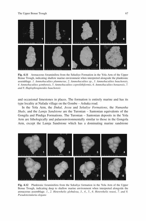
Fig. 4.11 Arenaceous foraminifera from the Sekuliye Formation in the Yola Arm of the UpperBenue Trough, indicating shallow marine environment when interpreted alongside the planktonicassemblage. 1. Ammobaculites plummerae, 2. Ammobaculites sp., 3. Ammobaculites bauchensis,4. Ammobaculites gombensis, 5. Ammobaculites coprolithiformis, 6. Ammobaculites benuensis, 7.and 8. Haplophragmoides bauchensis
and occasional limestones in places. The formation is entirely marine and has itstype locality at Nafada village on the Gombe – Ashaka road.
In the Yola Arm, the Dukul, Jessu and Sekuliye Formations, the NumanhaShale, and the Lamja Sandstone are the Turonian – Santonian equivalents of theGongila and Pindiga Formations. The Turonian – Santonian deposits in the YolaArm are lithologically and palaeoenvironmentally similar to those in the GongolaArm, except the Lamja Sandstone which has a dominating marine sandstone
1 2 3 4
5 6 7 8
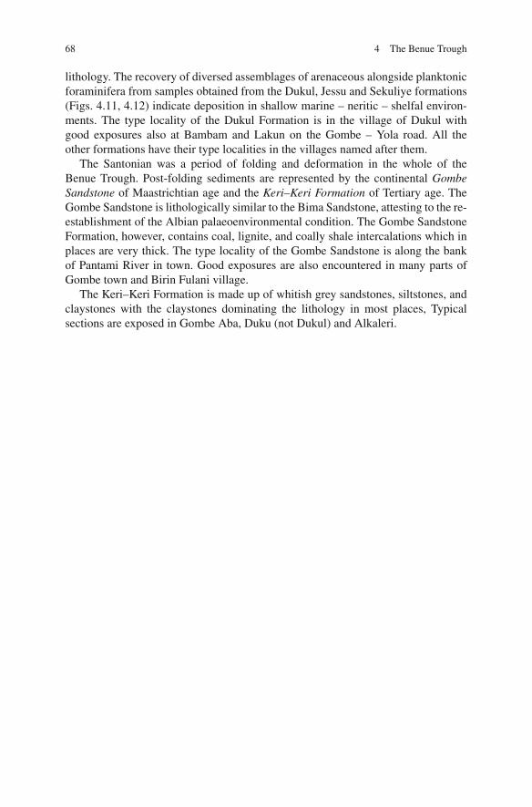
Fig. 4.12 Planktonic foraminifera from the Sekuliye formation in the Yola Arm of the UpperBenue Trough, indicating deep to shallow marine environment when interpreted alongside thearenaceous assemblage. 1., 2. Heterohelix globulosa, 3., 4., 5., 6. Heterohelix reussi, 7. and 8.Pseudotextularia elegans
68 4 The Benue Trough
lithology. The recovery of diversed assemblages of arenaceous alongside planktonicforaminifera from samples obtained from the Dukul, Jessu and Sekuliye formations(Figs. 4.11, 4.12) indicate deposition in shallow marine – neritic – shelfal environ-ments. The type locality of the Dukul Formation is in the village of Dukul withgood exposures also at Bambam and Lakun on the Gombe – Yola road. All theother formations have their type localities in the villages named after them.
The Santonian was a period of folding and deformation in the whole of theBenue Trough. Post-folding sediments are represented by the continental GombeSandstone of Maastrichtian age and the Keri–Keri Formation of Tertiary age. TheGombe Sandstone is lithologically similar to the Bima Sandstone, attesting to the re-establishment of the Albian palaeoenvironmental condition. The Gombe SandstoneFormation, however, contains coal, lignite, and coally shale intercalations which inplaces are very thick. The type locality of the Gombe Sandstone is along the bankof Pantami River in town. Good exposures are also encountered in many parts ofGombe town and Birin Fulani village.
The Keri–Keri Formation is made up of whitish grey sandstones, siltstones, andclaystones with the claystones dominating the lithology in most places, Typicalsections are exposed in Gombe Aba, Duku (not Dukul) and Alkaleri.


![Petroleum Potentials of the Nigerian Benue Trough and ... · the Central Benue Trough[30] perhaps caused by a com- pressional event In the Central Benue Trough, [31,32]. the regressive](https://img.pdfslide.us/doc/110x75/5f08f7a67e708231d42497ec/petroleum-potentials-of-the-nigerian-benue-trough-and-the-central-benue-trough30.jpg)