Embed Size (px)
Citation preview
States and counties are the major legally defined political and administrativeunits of the United States. As such, they serve as the primary geographic units for which the Bureau of the Census reports data. The Census Bureauprovides statistics for these entities in every decennial census of populationand housing, in every census of agriculture and governments, and in all theeconomic censuses. It tabulates data for States and counties in postcensalestimates and sometimes in its various intercensal sample surveys and pro-jections as well. In certain circumstances, it classifies entities as the statis-tical equivalents of States or of counties for data presentation purposes.
Because States, counties, and statistically equivalent entities are an integralpart of many Census Bureau data presentations, they occupy a prominentposition in the hierarchy of the basic geographic entities (see Figure 2-1 inChapter 2). Therefore, a major responsibility of the Census Bureau is tomaintain accurate maps and records of the boundaries and names of theseentities, and to identify their populations and other data items correctlythroughout the various phases of the census process. This chapter describesthe framework of the States, counties, and statistically equivalent entitiesused by the Census Bureau, and explains their function as geographic unitsin the process of data collection, tabulation, and dissemination.
The United States comprises the 50 States and the District of Columbia. Fordata presentation purposes, the Census Bureau treats the District of Colum-bia as the statistical equivalent of a State. Depending upon Federal law andthe scope of a particular census, sample survey, estimate, or projection, theCensus Bureau may apply the same treatment to the territories under U.S.sovereignty or jurisdiction; for the 1990 decennial census, these includedAmerican Samoa, Guam, the Northern Mariana Islands, Palau, Puerto Rico,and the Virgin Islands of the United States. For several other entities underU.S. jurisdiction, the Census Bureau publishes only decennial census popu-lation counts and area measurements; for the 1990 census, these were the
States, Counties, Equivalent Entities 4-1
States, Counties, and Statistically Equivalent Entities
Chapter 4
4-2 States, Counties, Equivalent Entities
Midway Islands; Wake Island; Johnston Atoll; Navassa, Baker, Howlandand Jarvis Islands; Kingman Reef; and Palmyra Atoll. In recent decennialcensuses, the Census Bureau also provided statistics as State equivalentsfor the Canal Zone and the Trust Territory of the Pacific Islands (see Chap-ter 7, “Puerto Rico and the Outlying Areas”). The designation Common-wealth is part of the official name of four States (Kentucky, Massachusetts,Pennsylvania, and Virginia), of Puerto Rico, and of the Northern MarianaIslands. In the interest of uniformity, the Census Bureau does not use theterm for its data presentations.
For most States, counties are the primary administrative divisions. Thereare exceptions, however; Louisiana has parishes, while Alaska has boroughsfor the organized portion of its territory. Because a large part of Alaskais not in any organized borough, the State and the Census Bureau coop-eratively have subdivided the unorganized portion of Alaska into censusareas for the purposes of presenting statistical data. Three States (Mary-land, Missouri, and Nevada) each have one city that is governmentally inde-pendent of county organization; Virginia currently has 41 such cities. Forboth legal and statistical presentation purposes, these independent citiesconstitute primary administrative divisions of their States. Part of Yellow-stone National Park in Montana is not within any county, therefore theCensus Bureau treats it as the statistical equivalent of a county. The Districtof Columbia has no primary administrative divisions; the Census Bureautreats its entire area as the statistical equivalent of both a State and a county.
The various entities that the Census Bureau treats as the statistical equiva-lents of counties in Puerto Rico and the Outlying Areas (see Chapter 7 fordetails) are as follows:
• American Samoa—3 districts and 2 islands; the counties in AmericanSamoa are treated as minor civil divisions
• Guam—the entire island
• The Northern Mariana Islands—4 municipalities
• Palau—16 States
States, Counties, Equivalent Entities 4-3
• Puerto Rico—78 municipios
• The Virgin Islands of the United States—3 islands
Historical BackgroundThe formation of States and counties has been an important theme inthe political and social history of the United States as the Nation acquirednew areas, settled them, and organized territorial, State, and local govern-ments. The present State boundaries evolved as the Nation expandedwestward; at the same time, counties developed and spread as units oflocal government and administration within the States and territories.There were more than 2,000 counties formed in the period from 1790to 1900. The various censuses of the United States have recognizedthese governmental units since the earliest enumerations.
Origin of States and StatehoodThe system of individual States within a Federal union has its roots in theAmerican colonial experience. By the time of the American Revolution,the identity and boundaries of the original 13 States had been evolvingduring 150 years of British colonization and settlement. Under British rule,the colonial legislatures gradually achieved various degrees of autonomyand self-government. The present Federal Union began in 1789 under theConstitution. The original 13 States joined the United States by their actof ratification. Article IV, Section 3, of the Constitution provides for theadmission of additional States. Thereby, both the national and State gov-ernments share the power to admit additional States. In the future, as inthe past, an area could achieve statehood only by an act of Congress thatfollows the broad guidelines of this Constitutional provision.
States, Territories, and the First Decennial CensusIn the colonial period, census-taking was a familiar element of the Amer-ican scene; the colonial authorities undertook 27 enumerations of thevarious colonies between 1624 and 1773. Article I, Section 2, of the Con-stitution calls for a population census as the basis for apportioning theseats in the Congress. The requirement for a census and, implicitly, therecognition of States in the geographic structure of the Census Bureau’s
4-4 States, Counties, Equivalent Entities
data tabulations, became part of the new Federal Government’s powersand duties.
The 1790 census, the first national enumeration of the United States, includedthe original 13 States as well as other areas that later would be formed intoStates. At that time, Virginia included what is now the State of West Virginia.The first national census reported separate counts for the districts of Ken-tucky, Maine, Vermont, and the area that is now Tennessee. The actualenumeration covered only the settled area, or about one-third of the newNation’s land area. It excluded much of northern Maine, upstate New York,and western and central Pennsylvania. West of the Alleghenies, the 1790enumeration covered only a few settlements in present-day Kentucky andTennessee. It included only the eastern third of present-day Georgia, andnone of Alabama and Mississippi. However, it did not encompass any ofthe Northwest Territory, because that area was not under the effectivecontrol of the U.S. Government or any of the States.
Westward Expansion, New States, and the Decennial CensusNew States generally originated as part of the process of western expansionand settlement, with the exceptions of Maine (created from Massachusetts)and West Virginia (created from Virginia). Census coverage followed closelybehind the addition of new territory; as the frontier moved west, successivedecennial enumerations covered the newly settled areas.
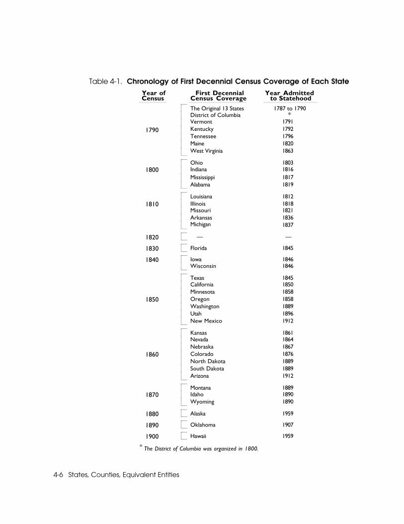
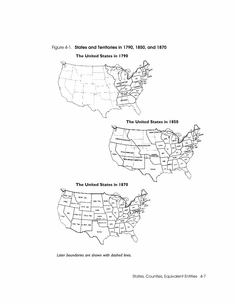
Identifying the many boundary shifts and name changes of the territoriesis beyond the scope of this chapter, as is providing detailed comparisonsbetween the areas enumerated for the first time and the areas of the pres-ent-day States. Nevertheless, it is worthwhile to mention briefly some ofthese developments as they relate to the first coverage of areas in a decen-nial census of the United States. The maps in Figure 4-1 show the bounda-ries of the States and territories recognized for the 1790, 1850, and 1870decennial censuses; the last major rearrangements of territorial bounda-ries and names occurred in the 1850s and 1860s. Table 4-1 shows the firstdecennial census that included the geographic area of each State, togetherwith the date when each State was admitted to the Union. By the time of
States, Counties, Equivalent Entities 4-5
the 1870 census, except for the boundary separating the Dakotas and themerger of the two territories that formed Oklahoma, the States and terri-torial boundaries of the conterminous United States were essentially fixed.For convenience, the list refers to the States in terms of their present areaand boundaries; except for the original 13, usually that area still was a terri-tory or part of a territory at the time of its first Federal census, sometimeswith a different name.
In almost all cases, each State or part of a State (other than the original 13)appeared in at least one decennial enumeration before it achieved state-hood. The exception is Texas, which was an independent republic beforeits admission to the Union in 1845 and first appeared in the 1850 census.The 1880 census marked the first enumeration of Alaska. The 1890 censusadded the Indian Territory and the Oklahoma Territory (combined in1907 to form the State of Oklahoma), and also reported data for Ameri-can Indian reservations in other States and territories. The geographiccoverage of the 1900 census, which added Hawaii, encompassed theentire area of the present United States.
The Development and Spread of CountiesThe county originated as an administrative unit in England; early settlersbrought the concept with them to the colonies. Throughout the colonialperiod, counties evolved as units of local government or administration.However, their importance varied from region to region in response todifferent economic, social, and political conditions. Long before the Rev-olution, three distinct systems had developed:
• In much of New England, the compact pattern of settlement favoredthe town as the local governing body; the county, a geographic group-ing of towns, tended to be a legal entity that existed for judicial ratherthan general governmental purposes.
• In the South, with its dispersed farms and plantations, the countybecame the most important unit of local administration; towns (ortownships) generally did not develop as local, self-governing unitsin the New England tradition.
4-6 States, Counties, Equivalent Entities
Table 4-1. Chronology of First Decennial Census Coverage of Each State Year of Census
First DecennialCensus Coverage
Year Admitted to Statehood
The Original 13 States 1787 to 1790District of Columbia *Vermont 1791
1790 Kentucky 1792Tennessee 1796Maine 1820West Virginia 1863
Ohio 18031800 Indiana 1816
Mississippi 1817Alabama 1819
Louisiana 18121810 Illinois 1818
Missouri 1821Arkansas 1836Michigan 1837
1820 — —
1830 Florida 1845
1840 Iowa 1846Wisconsin 1846
Texas 1845California 1850Minnesota 1858
1850 Oregon 1858Washington 1889Utah 1896New Mexico 1912
Kansas 1861Nevada 1864Nebraska 1867
1860 Colorado 1876North Dakota 1889South Dakota 1889Arizona 1912
Montana 18891870 Idaho 1890
Wyoming 1890
1880 Alaska 1959
1890 Oklahoma 1907
1900 Hawaii 1959
* The District of Columbia was organized in 1800.
States, Counties, Equivalent Entities 4-7
Figure 4-1. States and Territories in 1790, 1850, and 1870
The United States in 1790
The United States in 1850
The United States in 1870
Later boundaries are shown with dashed lines.
4-8 States, Counties, Equivalent Entities
• In the Middle Colonies of New Jersey, New York, and Pennsylvania,counties were important units of government, but they also containedtownships (towns in New York), that had varying degrees of recogni-tion and significance for some local governmental functions.
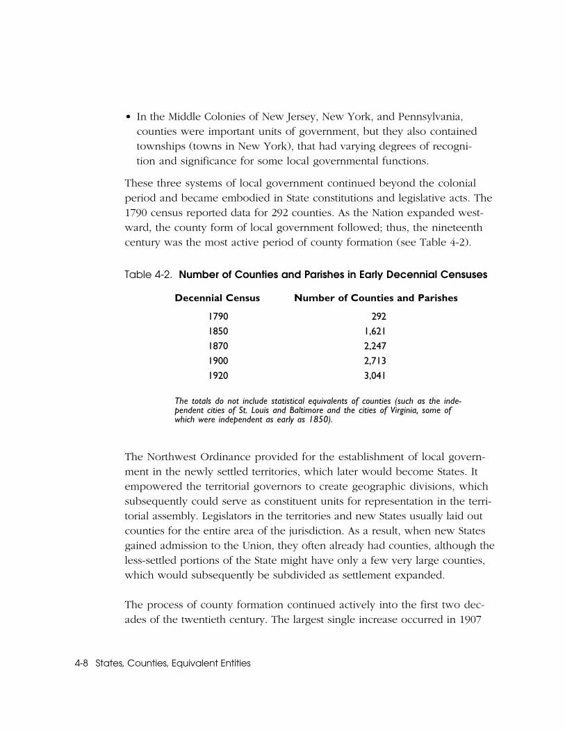
These three systems of local government continued beyond the colonialperiod and became embodied in State constitutions and legislative acts. The1790 census reported data for 292 counties. As the Nation expanded west-ward, the county form of local government followed; thus, the nineteenthcentury was the most active period of county formation (see Table 4-2).
Table 4-2. Number of Counties and Parishes in Early Decennial Censuses
Decennial Census Number of Counties and Parishes
1790 292
1850 1,621
1870 2,247
1900 2,713
1920 3,041
The totals do not include statistical equivalents of counties (such as the inde-pendent cities of St. Louis and Baltimore and the cities of Virginia, some ofwhich were independent as early as 1850).
The Northwest Ordinance provided for the establishment of local govern-ment in the newly settled territories, which later would become States. Itempowered the territorial governors to create geographic divisions, whichsubsequently could serve as constituent units for representation in the terri-torial assembly. Legislators in the territories and new States usually laid outcounties for the entire area of the jurisdiction. As a result, when new Statesgained admission to the Union, they often already had counties, although theless-settled portions of the State might have only a few very large counties,which would subsequently be subdivided as settlement expanded.
The process of county formation continued actively into the first two dec-ades of the twentieth century. The largest single increase occurred in 1907
States, Counties, Equivalent Entities 4-9
when Oklahoma became a State and organized 54 new counties from theIndian Territory. There were other sizable increases in county formationbetween 1910 and 1920, when Montana and Idaho almost doubled theirnumber of existing counties by adding 23 and 21 new counties, respectively.
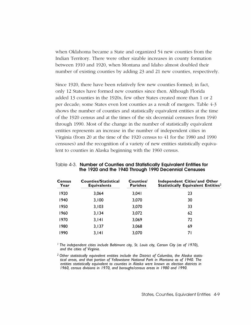
Since 1920, there have been relatively few new counties formed; in fact,only 12 States have formed new counties since then. Although Floridaadded 13 counties in the 1920s, few other States created more than 1 or 2per decade; some States even lost counties as a result of mergers. Table 4-3shows the number of counties and statistically equivalent entities at the timeof the 1920 census and at the times of the six decennial censuses from 1940through 1990. Most of the change in the number of statistically equivalententities represents an increase in the number of independent cities inVirginia (from 20 at the time of the 1920 census to 41 for the 1980 and 1990censuses) and the recognition of a variety of new entities statistically equiva-lent to counties in Alaska beginning with the 1960 census.
Table 4-3. Number of Counties and Statistically Equivalent Entities forthe 1920 and the 1940 Through 1990 Decennial Censuses
Census Year
Counties/StatisticalEquivalents
Counties/ Parishes
Independent Cities1and OtherStatistically Equivalent Entities2
1920 3,064 3,041 23
1940 3,100 3,070 30
1950 3,103 3,070 33
1960 3,134 3,072 62
1970 3,141 3,069 72
1980 3,137 3,068 69
1990 3,141 3,070 71
1 The independent cities include Baltimore city, St. Louis city, Carson City (as of 1970), and the cities of Virginia.2 Other statistically equivalent entities include the District of Columbia, the Alaska statis- tical areas, and that portion of Yellowstone National Park in Montana as of 1940. The entities statistically equivalent to counties in Alaska were known as election districts in 1960, census divisions in 1970, and boroughs/census areas in 1980 and 1990.
4-10 States, Counties, Equivalent Entities
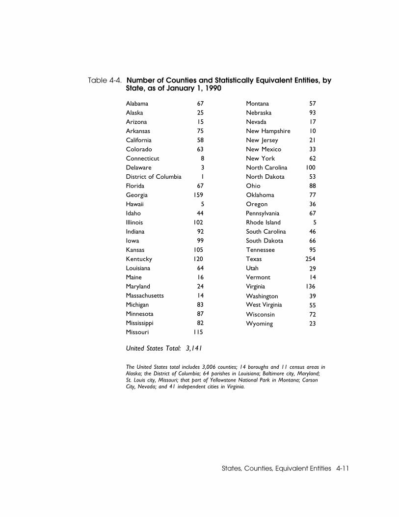
Table 4-4 lists the number of counties and equivalent entities in each Stateand the District of Columbia on January 1, 1990. Between the 1980 and 1990decennial censuses, Arizona and New Mexico each established an additionalcounty, and Alaska established two additional boroughs. One of the bor-oughs established in Alaska (Northwest Arctic) in effect replaced a censusarea (Kobuk), resulting in a net increase of two statistically equivalent enti-ties. Nevada formed the new county of Bullfrog in 1987; however, its crea-tion was nullified by the courts in 1988. The total number of counties andstatistically equivalent entities at the time of the 1990 census was 3,141.In Alaska, two additional entities, Denali borough (established December1990) and Yakutat borough (established 1992), have been formed sincethe 1990 census.
Legal/Statistical Basis for Census Bureau RecognitionStates and the statistically equivalent entities for which the Census Bureautabulates data are legal entities, with boundaries prescribed by laws, treaties,and other governmental actions. Title 13, United States Code, in Chapter 5,“Censuses,” Subchapter II, sections 141 (a) and (b), mandates the countingand tabulating of the population of the individual States and entities. There-fore, the Census Bureau uses the States, the District of Columbia, and theterritories of the United States as a primary level of geography; it retainstheir identity throughout the data collection, tabulation, and disseminationphases of every census.
Counties and Statistically Equivalent Entities of the United StatesMuch the same situation applies to the Nation’s counties and other statis-tically equivalent entities. All but a few of these entities are defined legally;that is, they are created by State law or some other administrative action.State constitutions or other laws generally specify counties (parishes inLouisiana, boroughs in Alaska, independent cities in four States) as thedivisions of each State, and assign responsibilities to them for providingvarious aspects of local government. On this basis, it is logical for theCensus Bureau to use these entities as the major geographic units in itsdata products. In addition, because counties and similar entities generallyencompass the entire land area of each State and statistically equivalent
States, Counties, Equivalent Entities 4-11
Table 4-4. Number of Counties and Statistically Equivalent Entities, byState, as of January 1, 1990
Alabama 67 Montana 57Alaska 25 Nebraska 93Arizona 15 Nevada 17Arkansas 75 New Hampshire 10California 58 New Jersey 21Colorado 63 New Mexico 33Connecticut 8 New York 62Delaware 3 North Carolina 100District of Columbia 1 North Dakota 53Florida 67 Ohio 88Georgia 159 Oklahoma 77Hawaii 5 Oregon 36Idaho 44 Pennsylvania 67Illinois 102 Rhode Island 5Indiana 92 South Carolina 46Iowa 99 South Dakota 66Kansas 105 Tennessee 95Kentucky 120 Texas 254Louisiana 64 Utah 29Maine 16 Vermont 14Maryland 24 Virginia 136Massachusetts 14 Washington 39Michigan 83 West Virginia 55Minnesota 87 Wisconsin 72Mississippi 82 Wyoming 23Missouri 115
United States Total: 3,141
The United States total includes 3,006 counties; 14 boroughs and 11 census areas inAlaska; the District of Columbia; 64 parishes in Louisiana; Baltimore city, Maryland;St. Louis city, Missouri; that part of Yellowstone National Park in Montana; CarsonCity, Nevada; and 41 independent cities in Virginia.
4-12 States, Counties, Equivalent Entities
entity, they constitute a detailed, relatively stable network of geographicunits at a single geographic/governmental level for the entire United Statesand its territories. As such, they provide convenient units for data dissem-ination purposes. Of course, because most of these entities representlocal governmental units, their officials, as well as the officials of State andFederal agencies and other data users, require statistics for the countiesfrom each specific census. Because most censuses and sample surveysuse a single common set of counties and statistically equivalent entities,the identification of individual county units constitutes an important ele-ment in the Census Bureau’s work and in its data products.
Rhode Island’s counties exist only for the purpose of judicial administra-tion and have no associated governmental structure. In 1960, Connecticutabolished its county governments and transferred their functions to theState government; however, the State retained the former counties forelection and judicial purposes. Nevertheless, in both States, the CensusBureau continues to report many types of data for these county-typeentities, in part to retain data comparability with earlier censuses andthe data sets of other government agencies.
The Statistical Equivalents of Counties in Puerto Rico and theOutlying AreasFor Puerto Rico and the Outlying Areas, the Census Bureau uses variousgeographic units as the statistical equivalent of stateside counties. Thisoccurs where the size, geography, or administrative framework makethe units appropriate entities for such use. As in the 50 States, the statis-tical equivalents of counties in the Outlying Areas provide complete geo-graphic coverage for the entire area and population of each jurisdiction(see Chapter 7).
Boundaries and CodesTo effectively collect, process, and tabulate data for States, counties,and their statistically equivalent entities, the Census Bureau must ensurethat it has accurate records of the boundaries of, and names for, theseentities. The Census Bureau also must develop appropriate geographic
States, Counties, Equivalent Entities 4-13
code schemes and geographic relationship files to properly control andpresent the data it collects for these important governmental units.
Stability of State and County BoundariesThe boundaries of the primary governmental divisions of the UnitedStates, States, counties, and their statistical equivalents, generally are staticand change only rarely; however, transfers of territory do occur fromtime to time. By contrast, the boundaries of incorporated places andeven minor civil divisions are far more subject to change in most States.
Changes in State lines may result from legislation, court decisions, andother types of governmental action; changes in county boundaries area matter of State law. Such boundary changes also may stem from moreexact geographic descriptions, better maps, and improved surveyingtechniques. State boundaries may change by mutual agreement of thetwo State legislatures, subject to approval by the Congress.
In recent years, most boundary changes for counties have been minorand have not involved substantial shifts of population or land area. Theindependent cities in Virginia constitute an exception because theyoccasionally annex territory, as do the incorporated places in manyStates. Because the territory annexed by a Virginia city no longer is partof the county in which it had been located, changes in the boundariesof these independent cities also affect the boundaries of the adjacentcounty or counties. In other States, changes to counties occur on apiecemeal basis.
The Boundary and Annexation Survey (BAS)The Census Bureau has established procedures and programs to identifychanges in legal boundaries and to record when and where they occur.The Census Bureau’s Boundary and Annexation Survey (BAS), conductedat periodic intervals immediately before each decennial census, and annu-ally since 1972, determines the location of the boundaries of most majorlegal entities in the United States. The principal function of the BAS is tocollect and maintain information on the inventory, status, boundaries,
4-14 States, Counties, Equivalent Entities
and names of local governments (counties, minor civil divisions, andincorporated places), and to ascertain whether changes have occurred inthese entities. The Census Bureau obtains information about counties bysending questionnaires and maps to an official of each county (parish inLouisiana) in the United States, excluding Alaska, Connecticut, Hawaii, andRhode Island; in these States, because of the unusual status of the counties(boroughs in Alaska), the Census Bureau works with the appropriate Stateauthorities to obtain the required information. However, new counties(and boroughs in Alaska) are such a rare and major event that they usuallycome to the Census Bureau’s attention long before, and separate from, theannual BAS mailout. The Census Bureau obtains official confirmation anddocumentation of new counties, their boundaries, and their names fromappropriate State officials.
Any changes in county boundaries may reflect changes in State bounda-ries as well. The proper location of State and county boundaries on Cen-sus Bureau maps is a vital element of the data collection and tabulationprocess. The BAS enables the Census Bureau to maintain, on a consistentbasis, reasonably current records about changes in county boundariesthat occur through resurveying, legal actions, or other transfers of terri-tory that relocate county lines. In this way, the Census Bureau also accountsfor changes in State lines as reported by the counties on either side of theState boundary.
State and County CodesThe Census Bureau uses a system of numeric codes to identify every geo-graphic entity in its hierarchy. These geographic codes are basic compo-nents of the geographic reference files that the Census Bureau developsand maintains to process the results of its censuses and sample surveys.The codes obviate the need to relate data to the geographic entities byname; that is, the Census Bureau’s processing operations associate datawith the much shorter, fixed-length, unique numeric codes rather thanthe variable-length names of the geographic entities in its reference files.These files provide the basis for the tabulation and dissemination of thecollected data in their proper geographic units.
States, Counties, Equivalent Entities 4-15
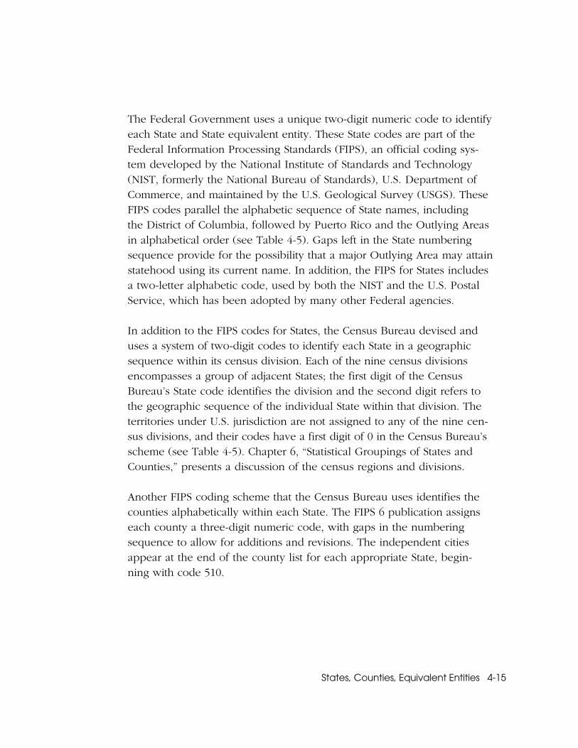
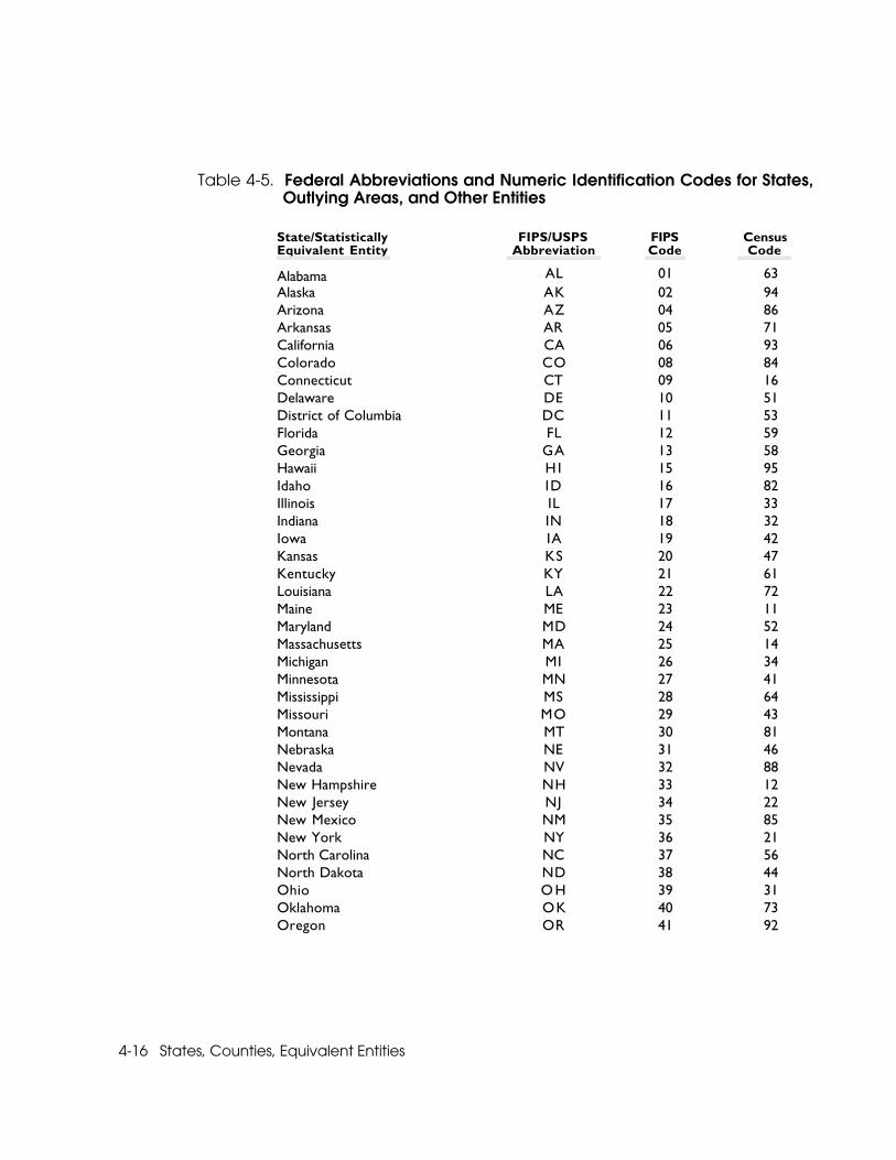
The Federal Government uses a unique two-digit numeric code to identifyeach State and State equivalent entity. These State codes are part of theFederal Information Processing Standards (FIPS), an official coding sys-tem developed by the National Institute of Standards and Technology(NIST, formerly the National Bureau of Standards), U.S. Department ofCommerce, and maintained by the U.S. Geological Survey (USGS). TheseFIPS codes parallel the alphabetic sequence of State names, includingthe District of Columbia, followed by Puerto Rico and the Outlying Areasin alphabetical order (see Table 4-5). Gaps left in the State numberingsequence provide for the possibility that a major Outlying Area may attainstatehood using its current name. In addition, the FIPS for States includesa two-letter alphabetic code, used by both the NIST and the U.S. PostalService, which has been adopted by many other Federal agencies.
In addition to the FIPS codes for States, the Census Bureau devised anduses a system of two-digit codes to identify each State in a geographicsequence within its census division. Each of the nine census divisionsencompasses a group of adjacent States; the first digit of the CensusBureau’s State code identifies the division and the second digit refers tothe geographic sequence of the individual State within that division. Theterritories under U.S. jurisdiction are not assigned to any of the nine cen-sus divisions, and their codes have a first digit of 0 in the Census Bureau’sscheme (see Table 4-5). Chapter 6, “Statistical Groupings of States andCounties,” presents a discussion of the census regions and divisions.
Another FIPS coding scheme that the Census Bureau uses identifies thecounties alphabetically within each State. The FIPS 6 publication assignseach county a three-digit numeric code, with gaps in the numberingsequence to allow for additions and revisions. The independent citiesappear at the end of the county list for each appropriate State, begin-ning with code 510.
4-16 States, Counties, Equivalent Entities
Table 4-5. Federal Abbreviations and Numeric Identification Codes for States,Outlying Areas, and Other Entities
State/Statistically FIPS/USPS FIPS CensusEquivalent Entity Abbreviation Code Code
Alabama AL 01 63Alaska AK 02 94Arizona AZ 04 86Arkansas AR 05 71California CA 06 93Colorado CO 08 84Connecticut CT 09 16Delaware DE 10 51District of Columbia DC 11 53Florida FL 12 59Georgia GA 13 58Hawaii H I 15 95Idaho ID 16 82Illinois IL 17 33Indiana IN 18 32Iowa IA 19 42Kansas KS 20 47Kentucky KY 21 61Louisiana LA 22 72Maine ME 23 11Maryland MD 24 52Massachusetts MA 25 14Michigan MI 26 34Minnesota MN 27 41Mississippi MS 28 64Missouri MO 29 43Montana MT 30 81Nebraska NE 31 46Nevada NV 32 88New Hampshire NH 33 12New Jersey NJ 34 22New Mexico NM 35 85New York NY 36 21North Carolina NC 37 56North Dakota ND 38 44Ohio O H 39 31Oklahoma OK 40 73Oregon OR 41 92
States, Counties, Equivalent Entities 4-17
Table 4-5. (cont.)
State/Statistically FIPS/USPS FIPS CensusEquivalent Entity Abbreviation Code Code
Pennsylvania PA 42 23Rhode Island RI 44 15South Carolina SC 45 57South Dakota SD 46 45Tennessee TN 47 62Texas TX 48 74Utah UT 49 87Vermont VT 50 13Virginia VA 51 54Washington WA 53 91West Virginia WV 54 55Wisconsin WI 55 35Wyoming WY 56 83American Samoa AS 60 03Guam GU 66 04Northern Mariana Islands MP 69 01Palau PW 70 02Puerto Rico PR 72 06U.S. Virgin Islands VI 78 07Foreign Areas and International Waters1 _ 99 _
U.S. Minor Outlying Islands2 OM 74 08Baker Island _ 81 08Howland Island _ 84 08Jarvis Island _ 86 08Johnston Atoll _ 67 08Kingman Reef _ 89 08Midway Islands _ 71 08Navassa Island _ 76 08Palmyra Atoll _ 95 08Wake Island _ 79 08
1 Foreign Areas and International Waters are areas bordering the United States and the OutlyingAreas. They have no official NIST/USPS abbreviation and require no State-level code.
2 The individual islands of the U.S. Minor Outlying Islands have no official NIST/USPS abbreviation.
4-18 States, Counties, Equivalent Entities
Relationships to Other Geographic EntitiesBoth States and counties provide complete coverage of all land area andpopulation in the United States at their geographic levels. Almost all othergeographic entities included in the Census Bureau’s data tabulations respectthe boundaries of States. American Indian reservations, however, may crossState boundaries. Also, some U.S. Postal Service five-digit ZIP Codes extendinto a second State. By design, statistical areas respect State lines, with twoexceptions: both metropolitan areas (defined by the Office of Managementand Budget) and urbanized areas may cross State boundaries.
Combinations of States and CountiesTwo types of statistical entities, the census region and the census division,encompass combinations of adjacent States. Both regions and divisions areconvenient geographic units for summarizing census and sample surveydata. For instance, the six New England States compose a single division;together with the Middle Atlantic Division, they form the Northeast Region(see Chapter 6, “Statistical Groupings of States and Counties”).
The nationwide geographic framework provided by the county makes itpossible to combine counties and statistically equivalent entities into largerstatistical units, which may encompass an entire State or selected parts ofseveral States. One of the best known examples of county combinationsare metropolitan areas (see Chapter 13, “Metropolitan Areas”).
Relationships in the Census Bureau’s Geographic HierarchyAt lower levels of the geographic hierarchy, most geographic areas respectthe boundaries of counties and county equivalents. The county subdivisions,census county divisions, minor civil divisions, and unorganized territories,provide complete coverage of all land area and population within eachcounty and statistically equivalent entity. On the other hand, in most States,incorporated places may cross county lines; census designated places maydo so in all States. Some incorporated places, such as Philadelphia andSan Francisco, comprise the entire area of a county (the city of New Yorkencompasses five entire counties); for such entities, the city and countyusually have a single government. In five instances at the time of the 1990
States, Counties, Equivalent Entities 4-19
census, a county and city consolidated their governments, and yet otherincorporated places continued to function within the county; the CensusBureau treats these entities as both counties and consolidated cities (seeChapter 9, “Places”). The small-area components of decennial censusgeography, census tracts/block numbering areas and their subdivisions(block groups and census blocks, and enumeration districts prior to the1990 census), always observe county boundaries.