Embed Size (px)
Citation preview
I-5 Corridor Reinforcement Project Draft EIS 4-1 November 2012
Words in bold and acronyms are defined in Chapter 32, Glossary and Acronyms.
Chapter 4 Proposed Action and Alternatives
This chapter describes the Proposed Action (the action alternatives), the No Action Alternative, and alternatives that were considered but eliminated from detailed study.
4.1 Proposed Action Alternatives
BPA considered a variety of environmental, technical, social and economic siting factors (see Section 2.1, Facility Siting), as well as comments from the public (see Section 1.6, Public Involvement and Major Issues), to develop a reasonable range of alternatives to evaluate in this EIS. For each potential alternative, BPA assessed whether the alternative would meet the identified need for the project and achieve the project’s purposes (see Section 1.3, Purposes). BPA developed four action alternatives from combinations of the route segments and substation sites (see Chapter 2, Facility Siting, Route Segments and Action Alternatives).
Each alternative includes a new substation near Castle Rock, Washington, a new 500-kV transmission line, a new Sundial Substation near Troutdale, Oregon, and new and improved access roads to these facilities. Also common to the action alternatives are the following: fiber optic cable installation on the transmission line for communications and equipment changes inside control houses at various BPA substations. All action alternatives cross the Columbia River in the same location.
Each action alternative includes three options that use different route segments and substation sites to complete the transmission line route. In this chapter, options and substation sites are described under each action alternative. Tower configurations also differ among the action alternatives. For some alternatives, existing transmission lines in certain locations would be removed and replaced. In some cases, new towers would be built in the same location as the removed towers; in other cases the new towers would be in different locations.
The project elements being considered are as follows (preferred project elements are noted with an *; common elements are noted in the description):
Transmission Line Routes:
o West Alternative and Options o Central Alternative and Options* o East Alternative and Options o Crossover Alternative and Options
Substations:
o New substation near Castle Rock at one of the following sites:
Monahan Creek site Baxter Road site Casey Road site*
Chapter 4 Proposed Action and Alternatives
4-2 I-5 Corridor Reinforcement Project Draft EIS November 2012
Maps and Figures
Maps of the alternatives referred to in this chapter can be found in Chapter 2. A table describing each action alternative, the actions that would occur within each alternative and option, and the resulting right-of-way configuration (the location of towers and lines on existing and proposed rights-of-way) for the different alternatives and options is included in Appendix B. Figures depicting the existing and proposed right-of-way configurations for the different alternatives and options are also referenced in the table and included in Appendix B. Figures of the designs proposed for different substation sites are included in this chapter. In addition, photomaps of all segments (that form the alternatives and options) and substations are included in Appendix C.
Tower Numbering
Tower numbers are based on the segment numbers. The first number of a specific tower is the segment number. For example, Tower 25/1 is the first tower in Segment 25. The first and last tower of each segment may have more than one number where segments intersect. For example, towers 1/18, 2/28 and 4/1 are the same tower, but have three designations because the tower is part of segments 1, 2, and 4.
Existing and New Right-of-Way
For portions of an action alternative where existing BPA right-of-way would be used, no new right-of-way would be needed unless noted in the text, tables, and figures. New right-of-way is typically 150-feet wide. There may be some areas where new right-of-way may be wider because of terrain, conductor swing, or other factors (see Appendix B).
o New Sundial Substation near Troutdale (common to all action alternatives, this includes tower removal and relocation of other utilities’ lines)
Access Roads (common to all action alternatives, this includes using existing access roads, improving existing roads, and constructing new roads)
Communications and Control Equipment (common to all action alternatives):
o Installation of fiber optic cable o Equipment changes inside existing control houses at various BPA substations
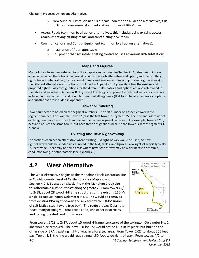
4.2 West Alternative
The West Alternative begins at the Monahan Creek substation site in Cowlitz County, west of Castle Rock (see Map 2-3 and Section 4.2.4, Substation Sites). From the Monahan Creek site this alternative runs southeast along Segment 2. From towers 2/1 to 2/18, about 28 wood H-Frame structures of the existing 115-kV single-circuit Lexington‐Delameter No. 1 line would be removed from existing BPA right-of-way and replaced with 500-kV single-circuit lattice-steel towers (see box). The route crosses Delameter Road, many drainages, Trout Lakes Road, and other local roads, and rolling forested land in this area.
From towers 2/18 to 2/27, about 15 wood H-frame structures of the Lexington-Delameter No. 1 line would be removed. The new 500-kV line would not be built in its place, but built on the other side of BPA’s existing right-of-way in a forested area. From Tower 2/27 to about 265 feet past Tower 4/1, the line would require new 150-foot-wide right-of-way. From towers 4/2 to
Chapter 4 Proposed Action and Alternatives
I-5 Corridor Reinforcement Project Draft EIS 4-3 November 2012
BPA’s Lexington-Delameter No. 1 115-kV Line
Cowlitz County PUD’s Lexington-Corduroy 115-kV Line
BPA’s Lexington-Delameter No. 1 115-kV line is on Segment 2 and would be removed in the West Alternative. The Lexington-Delameter No. 1 115-kV line is currently leased by Cowlitz County PUD. Cowlitz County PUD is upgrading its system. When the upgrades are completed, the PUD will no longer need this line and will terminate its lease with BPA. BPA has no other use for this line.
On Segment 9, Cowlitz County PUD leases BPA’s right-of-way for the PUD's Lexington-Corduroy 115-kV line. This lease can be revoked by BPA with 2 years notice. The West Alternative would remove this line to make room for the 500-kV line. BPA has met with Cowlitz County PUD and the PUD is aware that removing this line is part of the West Alternative. BPA would give Cowlitz County PUD notice if a decision is made to build a new line, and if the West Alternative is chosen route. In that case, because this 115-kV line is an integral part of Cowlitz County PUD’s system, Cowlitz County PUD would need to replace the line in a new location.
4/3, the route crosses existing BPA property around BPA’s Lexington Substation. Residential development surrounds the northeast side of Lexington Substation. From towers 4/3 to 4/5, the route parallels BPA’s Ross-Lexington No. 1 230-kV line on existing right-of-way, and crosses the Cowlitz River.
From towers 9/1 to 9/11, about 11 structures of the existing Cowlitz PUD 115-kV line would be removed so the 500-kV line could be built in existing right-of-way (see inset box). From towers 9/1 to 9/20, the route crosses the I-5 freeway and local roads, and continues on vacant, mostly forested, BPA right-of-way next to rural residential land and crosses the Coweeman River. Between towers 9/20 and 9/21, about 22.5 feet of new right-of-way would be required. From towers 9/21 to 9/82, the route continues through rural residential and forested land and some forested existing right-of-way, and parallels BPA's Ross-Lexington No. 1 230-kV line. The Washington Department of Natural Resources (WDNR) holds a forest riparian conservation easement near Tower 9/26. The route crosses the Kalama River, other smaller drainages, and many local roads.
From towers 25/1 to 25/18 the route continues to parallel the Ross-Lexington No. 1 230-kV line on existing right-of-way through forested, rural residential and agricultural land, crosses the Lewis River and State Route (SR) 503 near the city of Woodland, then turns due south. Between towers 25/18 and 25/19, about 12.5 feet of new right-of-way would be required as the route continues to parallel the Ross-Lexington line. At Tower 25/19 the transmission line route continues south paralleling the Ross-Lexington line in existing right-of-way through a mix of residential, agricultural, and forested land. It crosses the East Fork Lewis River, Salmon Creek, and other smaller drainages, SR 502, and many local roads, moves through a primarily residential area in Vancouver, crosses I-205, and turns west just north of Minnehaha.
Near BPA’s Ross Substation in Vancouver at about Tower 25/106, the West Alternative transmission line route turns east on existing right-of-way and parallels the Sifton-Ross No. 1/Bonneville PH1-Alcoa No. 2 115-kV double-circuit line. Between towers 25/110 and 25/141, the existing McNary-Ross No. 1 345-kV line would be removed (about 32 towers) and rebuilt in the same location, but using narrower towers so the new line could be built on existing right-of-way. This portion of Segment 25 crosses I-205, and runs through industrial, commercial and residential development next to the existing right-of-way. Between towers 25/141 and 25/151, an additional 30 feet of new right-of-way on the north side would be needed for the 500-kV towers. The route runs through agricultural land and near residential areas. Between
Chapter 4 Proposed Action and Alternatives
4-4 I-5 Corridor Reinforcement Project Draft EIS November 2012
towers 25/151 and 25/152, on the south side of the right-of-way, the Sifton‐Ross No. 1/Bonneville PH1‐Alcoa No. 2 double-circuit line becomes the Bonneville PH1‐Alcoa No. 2/North Camas‐Sifton double-circuit line after the line enters and exits Sifton Substation.
Between towers 36B/1 and 36B/2, the route crosses existing right-of-way over agricultural land and 155 feet of new right-of-way would be required for the new line. Between towers 36B/2 and 36B/7, the route continues east in new 155-foot-wide right-of-way paralleling the North Camas-Sifton No. 1/Bonneville PH1-Alcoa No. 2 double-circuit 115-kV line. From towers 36B/7 to 36B/8 the new 500-kV line would parallel the existing double-circuit line for one span through forested area, then replaces the double-circuit line at Tower 36B/8 (also referred to as 41/1) with a triple-circuit tower.
Between towers 41/1 and 41/8, about 10 towers of the North Camas-Sifton No. 1/Bonneville PH1-Alcoa No. 2 double-circuit 115-kV line would be removed and replaced with triple-circuit towers that would carry the two 115-kV lines on one side and the new 500-kV line on the other. In this area, the route turns southeast and 50 feet of new right-of-way would be needed (25 feet on either side) for the new line. This area is forested, rural residential, and recreation land (golf course). From towers 45/1 to 45/3, 50 feet of new right-of-way would be needed (25 feet on either side) to accommodate new triple-circuit towers. About three towers would be removed.
Between towers 45/3 and 45/6, the route turns south and requires 150 feet of new right-of-way. The transmission line route crosses over two existing lines and through forested land near rural residential development. From towers 50/1 to 50/3, the route continues south, then turns east to Tower 50/5, and requires 150 feet of new right-of-way. At Tower 50/5, the route turns southeast and parallels the North Camas-Sifton No. 1/Bonneville PH1-Alcoa No. 2 double-circuit 115-kV line until Tower 50/13, and would require 130 feet of new right-of-way through agricultural and rural residential land.
From towers 50/13 to 50/21 about eight towers of the North Camas-Sifton No. 1/Bonneville PH1-Alcoa No. 2 double-circuit line would be removed and replaced with nine triple-circuit towers. Fifty feet of new right-of-way would be needed, 25 feet on either side of the existing right-of-way, to accommodate the new towers. From towers 50/21 to 50/26, the route parallels the North Camas-Sifton No. 1/Bonneville PH1-Alcoa No. 2 double-circuit line in 130 feet of new right-of-way. The route runs through rural residential and agricultural land.
The route turns south on Segment 52. From towers 52/1 to 52/17, about 34 towers of the North Bonneville-Troutdale Nos. 1 and 2 230-kV lines would be removed and replaced with about 17 double-circuit 230-kV towers to make room for the new 500-kV line. The existing two 230-kV lines would be carried on the new double-circuit 230-kV towers on the east side of the existing right-of-way. The new 500-kV line would be built in existing right-of-way on the west side of the right-of-way through agricultural land, across the Washougal River, and west onto Lady Island in the Columbia River close to industrial, commercial, and residential areas. From towers 52/17 to 52/24 on Lady Island, 150 feet of new right-of-way would be required for the line. The route crosses the Columbia River between existing utility lines. South of the Columbia River, the route turns and runs through an industrial area to the Sundial substation site. Larger towers would be needed to cross the river (towers 52/20 to 52/22). These towers and the new towers built to carry the line into Sundial and Troutdale substations would be marked according to FAA requirements to minimize risk to air traffic (see Sections 3.2.1, Tower Types and 3.7, Obstruction Lighting and Marking).
Chapter 4 Proposed Action and Alternatives
I-5 Corridor Reinforcement Project Draft EIS 4-5 November 2012
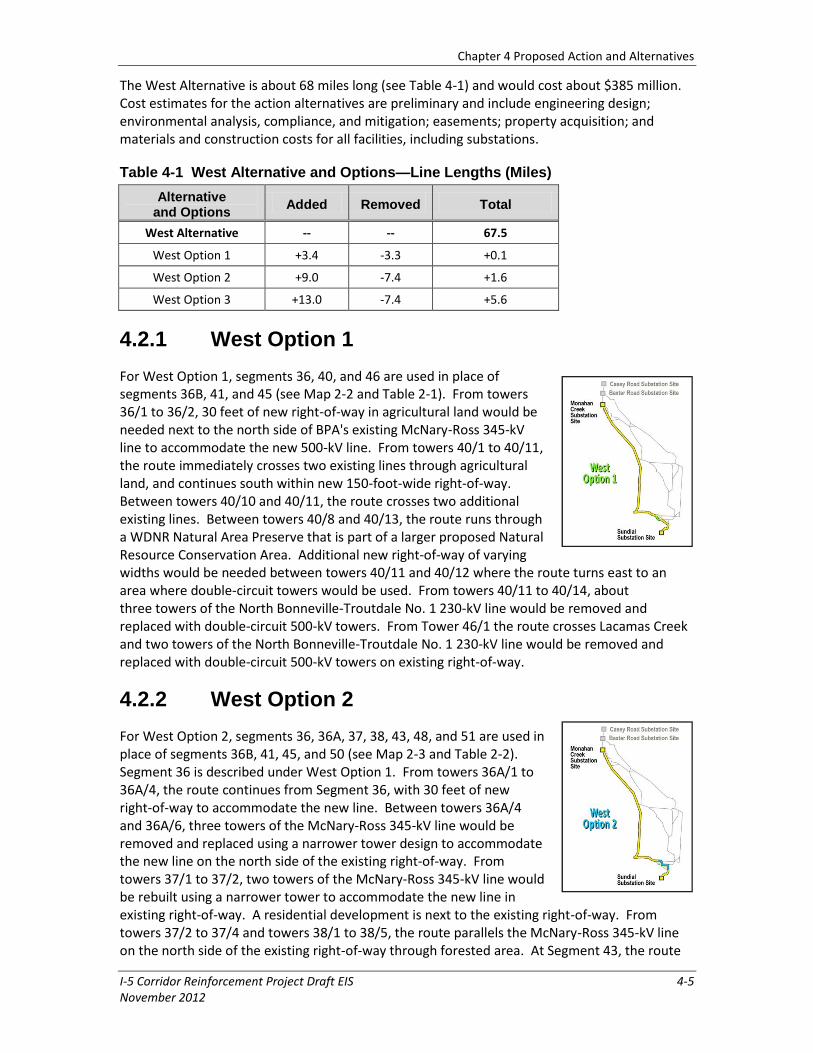
The West Alternative is about 68 miles long (see Table 4-1) and would cost about $385 million. Cost estimates for the action alternatives are preliminary and include engineering design; environmental analysis, compliance, and mitigation; easements; property acquisition; and materials and construction costs for all facilities, including substations.
Table 4-1 West Alternative and Options—Line Lengths (Miles)
Alternative and Options
Added Removed Total
West Alternative -- -- 67.5
West Option 1 +3.4 -3.3 +0.1
West Option 2 +9.0 -7.4 +1.6
West Option 3 +13.0 -7.4 +5.6
4.2.1 West Option 1
For West Option 1, segments 36, 40, and 46 are used in place of segments 36B, 41, and 45 (see Map 2-2 and Table 2-1). From towers 36/1 to 36/2, 30 feet of new right-of-way in agricultural land would be needed next to the north side of BPA's existing McNary-Ross 345-kV line to accommodate the new 500-kV line. From towers 40/1 to 40/11, the route immediately crosses two existing lines through agricultural land, and continues south within new 150-foot-wide right-of-way. Between towers 40/10 and 40/11, the route crosses two additional existing lines. Between towers 40/8 and 40/13, the route runs through a WDNR Natural Area Preserve that is part of a larger proposed Natural Resource Conservation Area. Additional new right-of-way of varying widths would be needed between towers 40/11 and 40/12 where the route turns east to an area where double-circuit towers would be used. From towers 40/11 to 40/14, about three towers of the North Bonneville-Troutdale No. 1 230-kV line would be removed and replaced with double-circuit 500-kV towers. From Tower 46/1 the route crosses Lacamas Creek and two towers of the North Bonneville-Troutdale No. 1 230-kV line would be removed and replaced with double-circuit 500-kV towers on existing right-of-way.
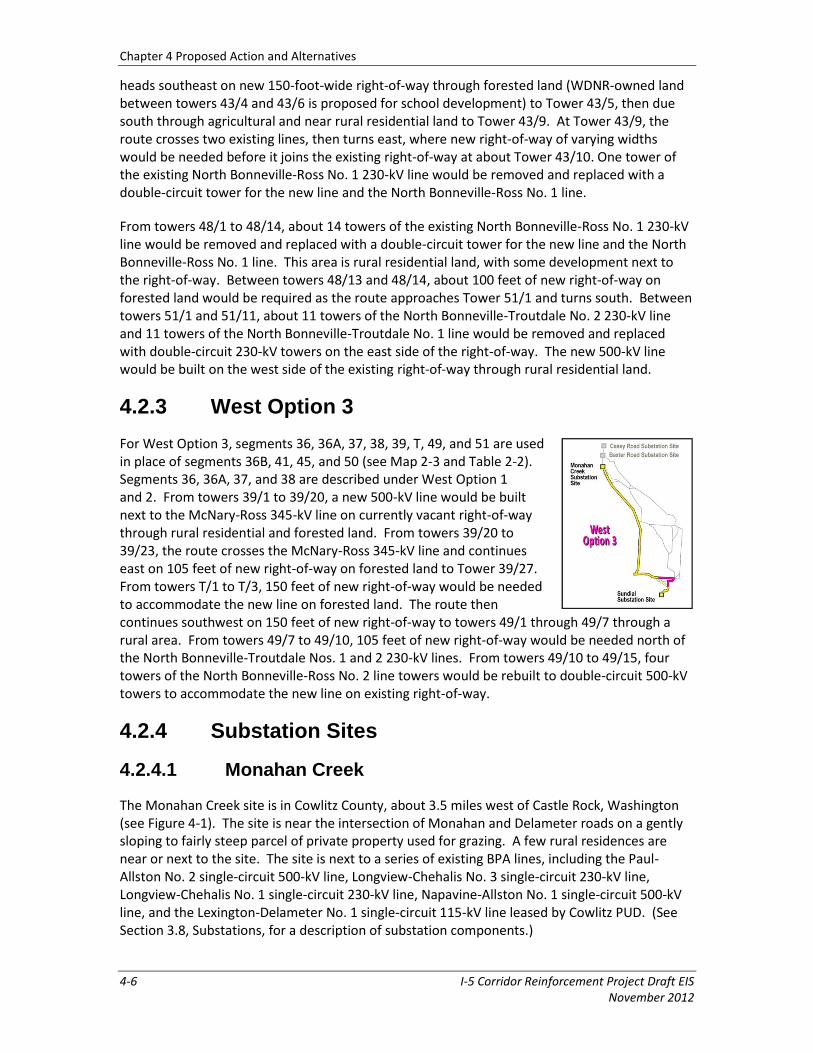
4.2.2 West Option 2
For West Option 2, segments 36, 36A, 37, 38, 43, 48, and 51 are used in place of segments 36B, 41, 45, and 50 (see Map 2-3 and Table 2-2). Segment 36 is described under West Option 1. From towers 36A/1 to 36A/4, the route continues from Segment 36, with 30 feet of new right-of-way to accommodate the new line. Between towers 36A/4 and 36A/6, three towers of the McNary-Ross 345-kV line would be removed and replaced using a narrower tower design to accommodate the new line on the north side of the existing right-of-way. From towers 37/1 to 37/2, two towers of the McNary-Ross 345-kV line would be rebuilt using a narrower tower to accommodate the new line in existing right-of-way. A residential development is next to the existing right-of-way. From towers 37/2 to 37/4 and towers 38/1 to 38/5, the route parallels the McNary-Ross 345-kV line on the north side of the existing right-of-way through forested area. At Segment 43, the route
Chapter 4 Proposed Action and Alternatives
4-6 I-5 Corridor Reinforcement Project Draft EIS November 2012
heads southeast on new 150-foot-wide right-of-way through forested land (WDNR-owned land between towers 43/4 and 43/6 is proposed for school development) to Tower 43/5, then due south through agricultural and near rural residential land to Tower 43/9. At Tower 43/9, the route crosses two existing lines, then turns east, where new right-of-way of varying widths would be needed before it joins the existing right-of-way at about Tower 43/10. One tower of the existing North Bonneville-Ross No. 1 230-kV line would be removed and replaced with a double-circuit tower for the new line and the North Bonneville-Ross No. 1 line.
From towers 48/1 to 48/14, about 14 towers of the existing North Bonneville-Ross No. 1 230-kV line would be removed and replaced with a double-circuit tower for the new line and the North Bonneville-Ross No. 1 line. This area is rural residential land, with some development next to the right-of-way. Between towers 48/13 and 48/14, about 100 feet of new right-of-way on forested land would be required as the route approaches Tower 51/1 and turns south. Between towers 51/1 and 51/11, about 11 towers of the North Bonneville-Troutdale No. 2 230-kV line and 11 towers of the North Bonneville-Troutdale No. 1 line would be removed and replaced with double-circuit 230-kV towers on the east side of the right-of-way. The new 500-kV line would be built on the west side of the existing right-of-way through rural residential land.
4.2.3 West Option 3
For West Option 3, segments 36, 36A, 37, 38, 39, T, 49, and 51 are used in place of segments 36B, 41, 45, and 50 (see Map 2-3 and Table 2-2). Segments 36, 36A, 37, and 38 are described under West Option 1 and 2. From towers 39/1 to 39/20, a new 500-kV line would be built next to the McNary-Ross 345-kV line on currently vacant right-of-way through rural residential and forested land. From towers 39/20 to 39/23, the route crosses the McNary-Ross 345-kV line and continues east on 105 feet of new right-of-way on forested land to Tower 39/27. From towers T/1 to T/3, 150 feet of new right-of-way would be needed to accommodate the new line on forested land. The route then continues southwest on 150 feet of new right-of-way to towers 49/1 through 49/7 through a rural area. From towers 49/7 to 49/10, 105 feet of new right-of-way would be needed north of the North Bonneville-Troutdale Nos. 1 and 2 230-kV lines. From towers 49/10 to 49/15, four towers of the North Bonneville-Ross No. 2 line towers would be rebuilt to double-circuit 500-kV towers to accommodate the new line on existing right-of-way.
4.2.4 Substation Sites
4.2.4.1 Monahan Creek
The Monahan Creek site is in Cowlitz County, about 3.5 miles west of Castle Rock, Washington (see Figure 4-1). The site is near the intersection of Monahan and Delameter roads on a gently sloping to fairly steep parcel of private property used for grazing. A few rural residences are near or next to the site. The site is next to a series of existing BPA lines, including the Paul-Allston No. 2 single-circuit 500-kV line, Longview-Chehalis No. 3 single-circuit 230-kV line, Longview-Chehalis No. 1 single-circuit 230-kV line, Napavine-Allston No. 1 single-circuit 500-kV line, and the Lexington-Delameter No. 1 single-circuit 115-kV line leased by Cowlitz PUD. (See Section 3.8, Substations, for a description of substation components.)

Chapter 4 Proposed Action and Alternatives
I-5 Corridor Reinforcement Project Draft EIS 4-7 November 2012
Figure 4-1 Monahan Creek Substation
The Monahan Creek substation site is about 806 feet by 780 feet, or about 14.4 acres. A 2.25-acre detention pond would be constructed at the intersection of Delameter, Garlock, and Otter roads to collect and filter substation water runoff. About 0.1 mile of new road would be constructed to access the substation from Delameter Road. No existing roads would be improved for the substation access road. Typically, when a new 500-kV substation is built and there are existing 500-kV lines in the vicinity, the lines are redirected into the new substation to further divide (or sectionalize) the system and ensure greater reliability so that in the event of an emergency or scheduled outage, different lines can be isolated. At this substation site, the Paul-Allston No. 2 and Napavine-Allston No. 1 500-kV lines would be redirected into and out of the new substation, which requires relocating these and other existing lines. The reconfiguration requires removing about 5 existing towers, rebuilding one tower, and constructing about 10 new towers. New spur roads would be needed and some existing access roads would need to be improved for the reconfiguration. The new 500-kV line would exit south of the new substation and continue to segments 1, 2, or 3, depending on the action alternative. If the project moves forward, redirecting the Paul-Allston No. 2 500-kV line could be done at a later time.
4.2.4.2 Sundial
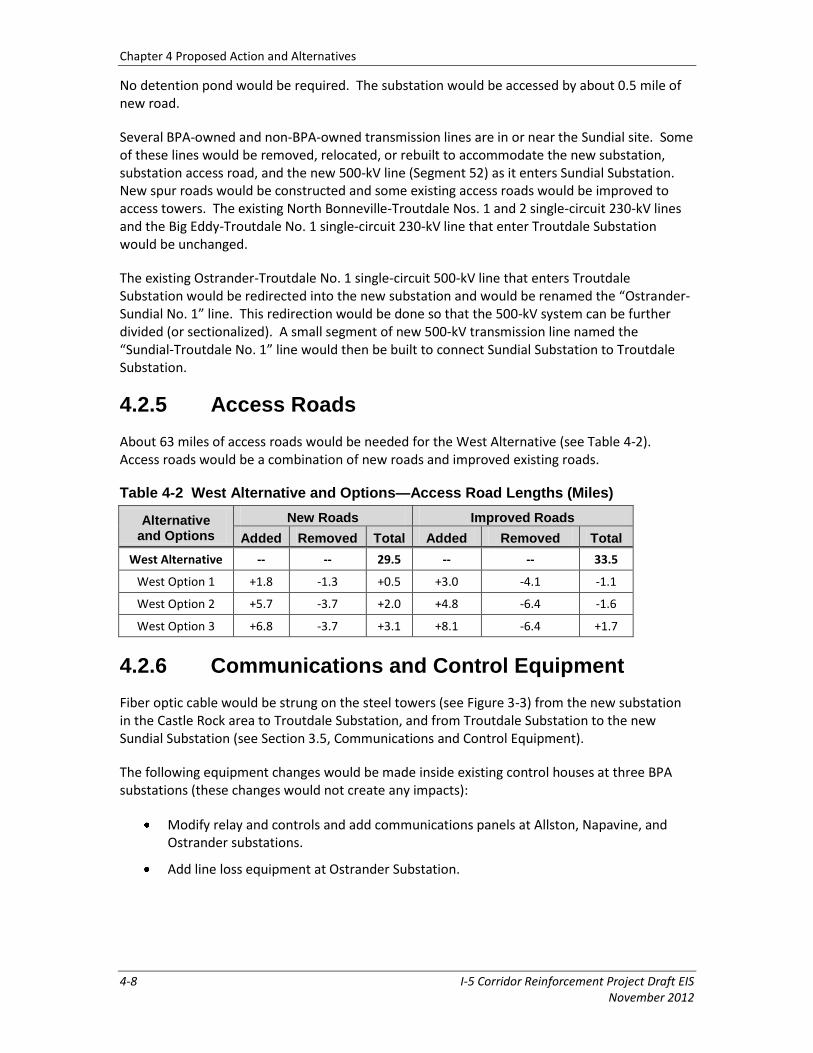
The Sundial substation site is about 1 mile north of I-84 and just south of the Columbia River in Troutdale, Oregon (see Figure 4-2). The site is part of a light industrial complex owned by the Port of Portland. BPA’s existing Troutdale Substation and non-BPA-owned substations are east of the site. The substation site is about 652 feet by 1,155 feet, or about 17.3 acres.
Chapter 4 Proposed Action and Alternatives
4-8 I-5 Corridor Reinforcement Project Draft EIS November 2012
No detention pond would be required. The substation would be accessed by about 0.5 mile of new road.
Several BPA-owned and non-BPA-owned transmission lines are in or near the Sundial site. Some of these lines would be removed, relocated, or rebuilt to accommodate the new substation, substation access road, and the new 500-kV line (Segment 52) as it enters Sundial Substation. New spur roads would be constructed and some existing access roads would be improved to access towers. The existing North Bonneville-Troutdale Nos. 1 and 2 single-circuit 230-kV lines and the Big Eddy-Troutdale No. 1 single-circuit 230-kV line that enter Troutdale Substation would be unchanged.
The existing Ostrander-Troutdale No. 1 single-circuit 500-kV line that enters Troutdale Substation would be redirected into the new substation and would be renamed the “Ostrander-Sundial No. 1” line. This redirection would be done so that the 500-kV system can be further divided (or sectionalized). A small segment of new 500-kV transmission line named the “Sundial-Troutdale No. 1” line would then be built to connect Sundial Substation to Troutdale Substation.
4.2.5 Access Roads
About 63 miles of access roads would be needed for the West Alternative (see Table 4-2). Access roads would be a combination of new roads and improved existing roads.
Table 4-2 West Alternative and Options—Access Road Lengths (Miles)
Alternative and Options
New Roads Improved Roads
Added Removed Total Added Removed Total
West Alternative -- -- 29.5 -- -- 33.5
West Option 1 +1.8 -1.3 +0.5 +3.0 -4.1 -1.1
West Option 2 +5.7 -3.7 +2.0 +4.8 -6.4 -1.6
West Option 3 +6.8 -3.7 +3.1 +8.1 -6.4 +1.7
4.2.6 Communications and Control Equipment
Fiber optic cable would be strung on the steel towers (see Figure 3-3) from the new substation in the Castle Rock area to Troutdale Substation, and from Troutdale Substation to the new Sundial Substation (see Section 3.5, Communications and Control Equipment).
The following equipment changes would be made inside existing control houses at three BPA substations (these changes would not create any impacts):
Modify relay and controls and add communications panels at Allston, Napavine, and Ostrander substations.
Add line loss equipment at Ostrander Substation.
Chapter 4 Proposed Action and Alternatives
I-5 Corridor Reinforcement Project Draft EIS 4-9 November 2012
Figure 4-2 Sundial Substation
Chapter 4 Proposed Action and Alternatives
4-10 I-5 Corridor Reinforcement Project Draft EIS November 2012
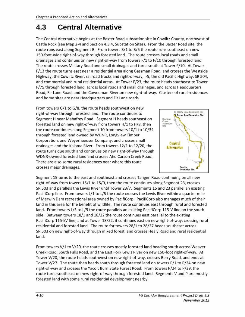
4.3 Central Alternative
The Central Alternative begins at the Baxter Road substation site in Cowlitz County, northwest of Castle Rock (see Map 2-4 and Section 4.3.4, Substation Sites). From the Baxter Road site, the route runs east along Segment B. From towers B/1 to B/5 the route runs southeast on new 150-foot-wide right-of-way through forested land. The route crosses local roads and small drainages and continues on new right-of-way from towers F/1 to F/10 through forested land. The route crosses Military Road and small drainages and turns south at Tower F/10. At Tower F/13 the route turns east near a residential area along Gassman Road, and crosses the Westside Highway, the Cowlitz River, railroad tracks and right-of-way, I-5, the old Pacific Highway, SR 504, and commercial and rural residential areas. At Tower F/23, the route heads southeast to Tower F/75 through forested land, across local roads and small drainages, and across Headquarters Road, Fir Lane Road, and the Coweeman River on new right-of-way. Clusters of rural residences and home sites are near Headquarters and Fir Lane roads.
From towers G/1 to G/8, the route heads southwest on new right-of-way through forested land. The route continues to Segment H near Mahafrey Road. Segment H heads southeast on forested land on new right-of-way from towers H/1 to H/8, then the route continues along Segment 10 from towers 10/1 to 10/34 through forested land owned by WDNR, Longview Timber Corporation, and Weyerhaeuser Company, and crosses small drainages and the Kalama River. From towers 12/1 to 12/20, the route turns due south and continues on new right-of-way through WDNR-owned forested land and crosses Aho Carson Creek Road. There are also some rural residences near where this route crosses major drainages.
Segment 15 turns to the east and southeast and crosses Tangen Road continuing on all new right-of-way from towers 15/1 to 15/9, then the route continues along Segment 23, crosses SR 503 and parallels the Lewis River until Tower 23/7. Segments 15 and 23 parallel an existing PacifiCorp line. From towers L/1 to L/5 the route crosses the Lewis River within a quarter mile of Merwin Dam recreational area owned by PacifiCorp. PacifiCorp also manages much of their land in this area for the benefit of wildlife. The route continues east through rural and forested land. From towers L/5 to L/9 the route parallels an existing PacifiCorp 115-V line on the south side. Between towers 18/1 and 18/22 the route continues east parallel to the existing PacifiCorp 115-kV line, and at Tower 18/22, it continues east on new right-of-way, crossing rural residential and forested land. The route for towers 28/1 to 28/27 heads southeast across SR 503 on new right-of-way through mixed forest, and crosses Healy Road and rural residential land.
From towers V/1 to V/20, the route crosses mostly forested land heading south across Weaver Creek Road, South Falls Road, and the East Fork Lewis River on new 150-foot right-of-way. At Tower V/20, the route heads southwest on new right-of-way, crosses Berry Road, and ends at Tower V/27. The route then heads south through forested land on towers P/1 to P/24 on new right-of-way and crosses the Yacolt Burn State Forest Road. From towers P/24 to P/39, the route turns southeast on new right-of-way through forested land. Segments V and P are mostly forested land with some rural residential development nearby.
Chapter 4 Proposed Action and Alternatives
I-5 Corridor Reinforcement Project Draft EIS 4-11 November 2012
At Segment 35, the route continues south on new right-of-way through forested land and along the edge of the City of Camas watershed, as well as scattered rural residential development, until it meets up with existing right-of-way and crosses over the McNary-Ross and North Bonneville-Ross No. 2 lines between towers 35/14 and 35/15. The route continues along Segments T, 49, 51, and 52 previously described under the West Alternative and West Option 3.
The Central Alternative is about 77 miles long (see Table 4-3) and would cost about $459 million.
Table 4-3 Central Alternative and Options—Lengths (Miles)
Alternative and Options
Added Removed Total
Central Alternative -- -- 77.3
Central Option 1 +2.5 -- +2.5
Central Option 2 +15.7 -18.0 -2.3
Central Option 3 +14.9 -20.8 -5.8
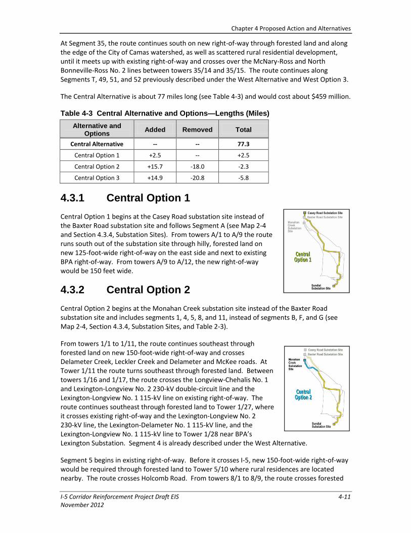
4.3.1 Central Option 1
Central Option 1 begins at the Casey Road substation site instead of the Baxter Road substation site and follows Segment A (see Map 2-4 and Section 4.3.4, Substation Sites). From towers A/1 to A/9 the route runs south out of the substation site through hilly, forested land on new 125-foot-wide right-of-way on the east side and next to existing BPA right-of-way. From towers A/9 to A/12, the new right-of-way would be 150 feet wide.
4.3.2 Central Option 2
Central Option 2 begins at the Monahan Creek substation site instead of the Baxter Road substation site and includes segments 1, 4, 5, 8, and 11, instead of segments B, F, and G (see Map 2-4, Section 4.3.4, Substation Sites, and Table 2-3).
From towers 1/1 to 1/11, the route continues southeast through forested land on new 150-foot-wide right-of-way and crosses Delameter Creek, Leckler Creek and Delameter and McKee roads. At Tower 1/11 the route turns southeast through forested land. Between towers 1/16 and 1/17, the route crosses the Longview-Chehalis No. 1 and Lexington-Longview No. 2 230-kV double-circuit line and the Lexington-Longview No. 1 115-kV line on existing right-of-way. The route continues southeast through forested land to Tower 1/27, where it crosses existing right-of-way and the Lexington-Longview No. 2 230-kV line, the Lexington-Delameter No. 1 115-kV line, and the Lexington-Longview No. 1 115-kV line to Tower 1/28 near BPA’s Lexington Substation. Segment 4 is already described under the West Alternative.
Segment 5 begins in existing right-of-way. Before it crosses I-5, new 150-foot-wide right-of-way would be required through forested land to Tower 5/10 where rural residences are located nearby. The route crosses Holcomb Road. From towers 8/1 to 8/9, the route crosses forested
Chapter 4 Proposed Action and Alternatives
4-12 I-5 Corridor Reinforcement Project Draft EIS November 2012
land on new 150-foot-wide right-of-way running northeast. Segment 11 heads southeast through forested land, with some scattered rural residences nearby, and crosses the South Fork of Ostrander Creek on new right-of-way. The route crosses the Coweeman River and Rose Valley Road between towers 11/14 and 11/15 and continues to Tower 11/21.
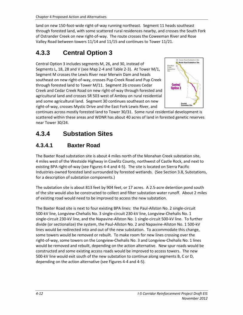
4.3.3 Central Option 3
Central Option 3 includes segments M, 26, and 30, instead of Segments L, 18, 28 and V (see Map 2-4 and Table 2-3). At Tower M/1, Segment M crosses the Lewis River near Merwin Dam and heads southeast on new right-of-way, crosses Pup Creek Road and Pup Creek through forested land to Tower M/11. Segment 26 crosses Cedar Creek and Cedar Creek Road on new right-of-way through forested and agricultural land and crosses SR 503 west of Amboy on rural residential and some agricultural land. Segment 30 continues southeast on new right-of-way, crosses Mystic Drive and the East Fork Lewis River, and continues across mostly forested land to Tower 30/31. Some rural residential development is scattered within these areas and WDNR has about 40 acres of land in forested genetic reserves near Tower 30/24.
4.3.4 Substation Sites
4.3.4.1 Baxter Road
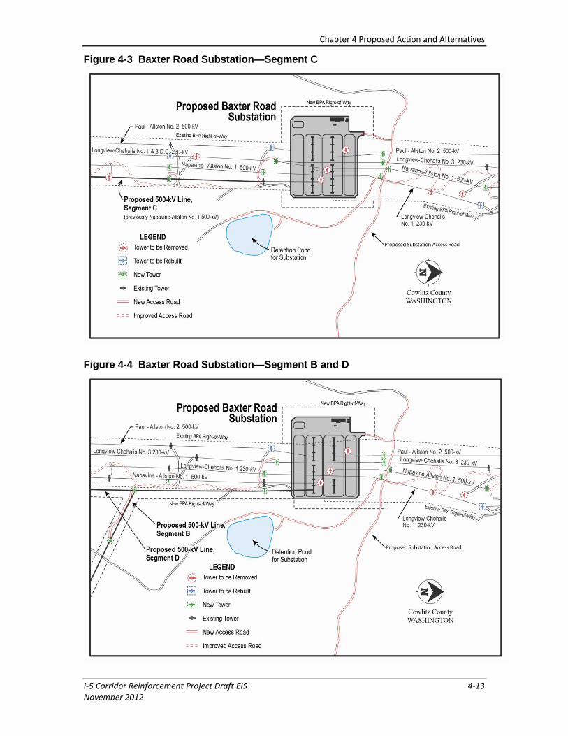
The Baxter Road substation site is about 4 miles north of the Monahan Creek substation site, 4 miles west of the Westside Highway in Cowlitz County, northwest of Castle Rock, and next to existing BPA right-of-way (see Figures 4-4 and 4-5). The site is located on Sierra Pacific Industries-owned forested land surrounded by forested wetlands. (See Section 3.8, Substations, for a description of substation components.)
The substation site is about 813 feet by 904 feet, or 17 acres. A 2.5-acre detention pond south of the site would also be constructed to collect and filter substation water runoff. About 2 miles of existing road would need to be improved to access the new substation.
The Baxter Road site is next to four existing BPA lines: the Paul-Allston No. 2 single-circuit 500-kV line, Longview-Chehalis No. 3 single-circuit 230-kV line, Longview-Chehalis No. 1 single-circuit 230-kV line, and the Napavine-Allston No. 1 single-circuit 500-kV line. To further divide (or sectionalize) the system, the Paul-Allston No. 2 and Napavine-Allston No. 1 500-kV lines would be redirected into and out of the new substation. To accommodate this change, some towers would be removed or rebuilt. To make room for new lines crossing over the right-of-way, some towers on the Longview-Chehalis No. 3 and Longview-Chehalis No. 1 lines would be removed and rebuilt, depending on the action alternative. New spur roads would be constructed and some existing access roads would be improved to access towers. The new 500-kV line would exit south of the new substation to continue along segments B, C or D, depending on the action alternative (see Figures 4-4 and 4-5).
Chapter 4 Proposed Action and Alternatives
I-5 Corridor Reinforcement Project Draft EIS 4-13 November 2012
Figure 4-3 Baxter Road Substation—Segment C
Figure 4-4 Baxter Road Substation—Segment B and D
Chapter 4 Proposed Action and Alternatives
4-14 I-5 Corridor Reinforcement Project Draft EIS November 2012
4.3.4.2 Casey Road
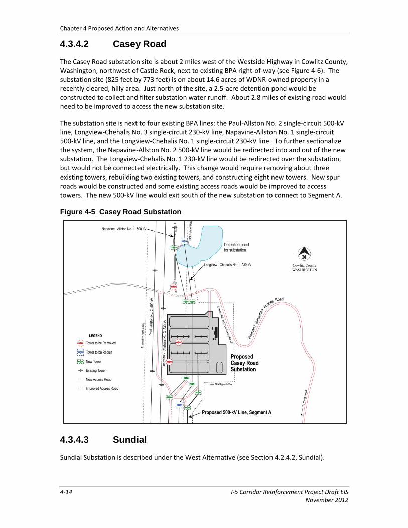
The Casey Road substation site is about 2 miles west of the Westside Highway in Cowlitz County, Washington, northwest of Castle Rock, next to existing BPA right-of-way (see Figure 4-6). The substation site (825 feet by 773 feet) is on about 14.6 acres of WDNR-owned property in a recently cleared, hilly area. Just north of the site, a 2.5-acre detention pond would be constructed to collect and filter substation water runoff. About 2.8 miles of existing road would need to be improved to access the new substation site.
The substation site is next to four existing BPA lines: the Paul-Allston No. 2 single-circuit 500-kV line, Longview-Chehalis No. 3 single-circuit 230-kV line, Napavine-Allston No. 1 single-circuit 500-kV line, and the Longview-Chehalis No. 1 single-circuit 230-kV line. To further sectionalize the system, the Napavine-Allston No. 2 500-kV line would be redirected into and out of the new substation. The Longview-Chehalis No. 1 230-kV line would be redirected over the substation, but would not be connected electrically. This change would require removing about three existing towers, rebuilding two existing towers, and constructing eight new towers. New spur roads would be constructed and some existing access roads would be improved to access towers. The new 500-kV line would exit south of the new substation to connect to Segment A.
Figure 4-5 Casey Road Substation
4.3.4.3 Sundial
Sundial Substation is described under the West Alternative (see Section 4.2.4.2, Sundial).
Chapter 4 Proposed Action and Alternatives
I-5 Corridor Reinforcement Project Draft EIS 4-15 November 2012
4.3.5 Access Roads
About 160 miles of access roads would be needed for the Central Alternative (see Table 4-4). Access roads would be a combination of new roads and improved existing roads.
Table 4-4 Central Alternative and Options—Access Road Lengths (Miles)
Alternative and Options
New Roads Improved Roads
Added Removed Total Added Removed Total
Central Alternative -- -- 41.4 -- -- 117.9
Central Option 1 +1.4 -0.4 +1.0 +13.3 -5.3 +8.0
Central Option 2 +10.3 -6.5 +3.8 +27.8 -37.4 -9.6
Central Option 3 +8.9 -9.5 -0.5 +11.8 -20.0 -8.2
4.3.6 Communications and Control Equipment
The installation of fiber optic cable on the transmission line for communications and the equipment changes inside control houses at various BPA substations described for the West Alternative (see Section 4.2.6, Communications and Control Equipment) also would occur under this alternative.
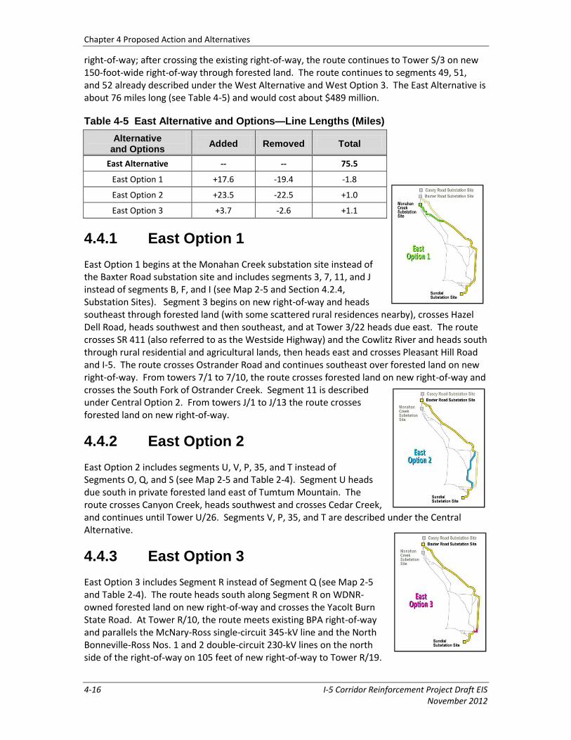
4.4 East Alternative
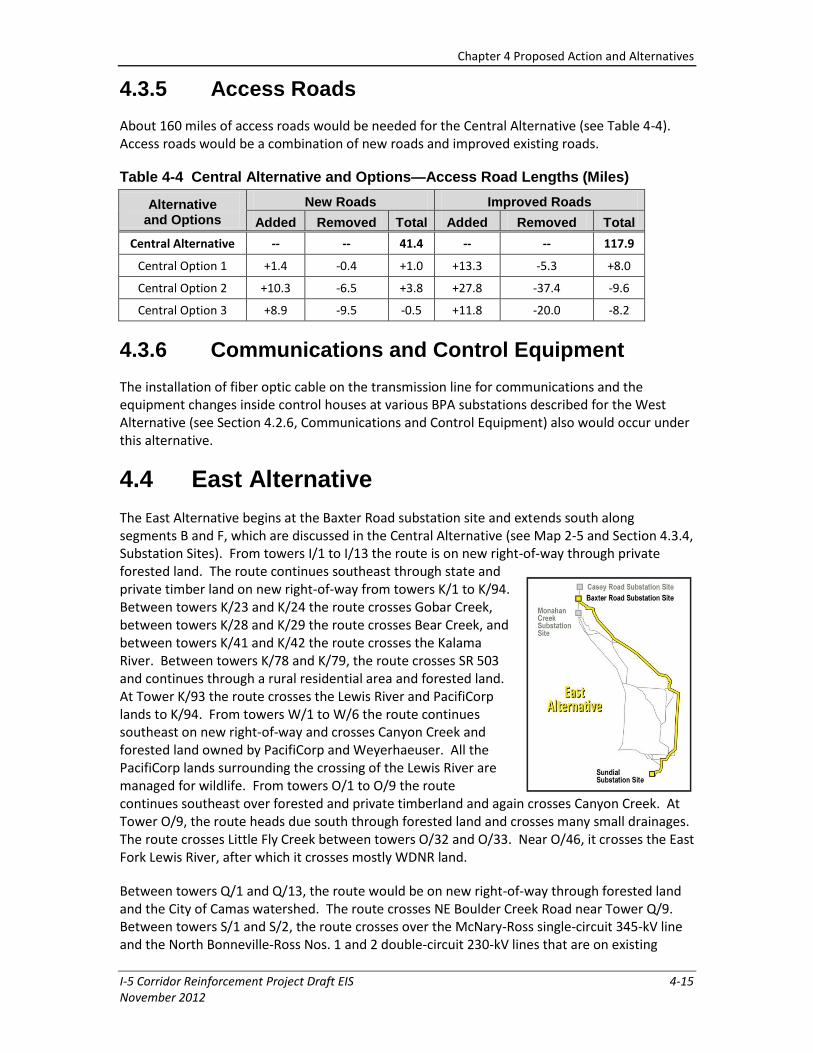
The East Alternative begins at the Baxter Road substation site and extends south along segments B and F, which are discussed in the Central Alternative (see Map 2-5 and Section 4.3.4, Substation Sites). From towers I/1 to I/13 the route is on new right-of-way through private forested land. The route continues southeast through state and private timber land on new right-of-way from towers K/1 to K/94. Between towers K/23 and K/24 the route crosses Gobar Creek, between towers K/28 and K/29 the route crosses Bear Creek, and between towers K/41 and K/42 the route crosses the Kalama River. Between towers K/78 and K/79, the route crosses SR 503 and continues through a rural residential area and forested land. At Tower K/93 the route crosses the Lewis River and PacifiCorp lands to K/94. From towers W/1 to W/6 the route continues southeast on new right-of-way and crosses Canyon Creek and forested land owned by PacifiCorp and Weyerhaeuser. All the PacifiCorp lands surrounding the crossing of the Lewis River are managed for wildlife. From towers O/1 to O/9 the route continues southeast over forested and private timberland and again crosses Canyon Creek. At Tower O/9, the route heads due south through forested land and crosses many small drainages. The route crosses Little Fly Creek between towers O/32 and O/33. Near O/46, it crosses the East Fork Lewis River, after which it crosses mostly WDNR land.
Between towers Q/1 and Q/13, the route would be on new right-of-way through forested land and the City of Camas watershed. The route crosses NE Boulder Creek Road near Tower Q/9. Between towers S/1 and S/2, the route crosses over the McNary-Ross single-circuit 345-kV line and the North Bonneville-Ross Nos. 1 and 2 double-circuit 230-kV lines that are on existing
Chapter 4 Proposed Action and Alternatives
4-16 I-5 Corridor Reinforcement Project Draft EIS November 2012
right-of-way; after crossing the existing right-of-way, the route continues to Tower S/3 on new 150-foot-wide right-of-way through forested land. The route continues to segments 49, 51, and 52 already described under the West Alternative and West Option 3. The East Alternative is about 76 miles long (see Table 4-5) and would cost about $489 million.
Table 4-5 East Alternative and Options—Line Lengths (Miles)
Alternative and Options
Added Removed Total
East Alternative -- -- 75.5
East Option 1 +17.6 -19.4 -1.8
East Option 2 +23.5 -22.5 +1.0
East Option 3 +3.7 -2.6 +1.1
4.4.1 East Option 1
East Option 1 begins at the Monahan Creek substation site instead of the Baxter Road substation site and includes segments 3, 7, 11, and J instead of segments B, F, and I (see Map 2-5 and Section 4.2.4, Substation Sites). Segment 3 begins on new right-of-way and heads southeast through forested land (with some scattered rural residences nearby), crosses Hazel Dell Road, heads southwest and then southeast, and at Tower 3/22 heads due east. The route crosses SR 411 (also referred to as the Westside Highway) and the Cowlitz River and heads south through rural residential and agricultural lands, then heads east and crosses Pleasant Hill Road and I-5. The route crosses Ostrander Road and continues southeast over forested land on new right-of-way. From towers 7/1 to 7/10, the route crosses forested land on new right-of-way and crosses the South Fork of Ostrander Creek. Segment 11 is described under Central Option 2. From towers J/1 to J/13 the route crosses forested land on new right-of-way.
4.4.2 East Option 2
East Option 2 includes segments U, V, P, 35, and T instead of Segments O, Q, and S (see Map 2-5 and Table 2-4). Segment U heads due south in private forested land east of Tumtum Mountain. The route crosses Canyon Creek, heads southwest and crosses Cedar Creek, and continues until Tower U/26. Segments V, P, 35, and T are described under the Central Alternative.
4.4.3 East Option 3
East Option 3 includes Segment R instead of Segment Q (see Map 2-5 and Table 2-4). The route heads south along Segment R on WDNR-owned forested land on new right-of-way and crosses the Yacolt Burn State Road. At Tower R/10, the route meets existing BPA right-of-way and parallels the McNary-Ross single-circuit 345-kV line and the North Bonneville-Ross Nos. 1 and 2 double-circuit 230-kV lines on the north side of the right-of-way on 105 feet of new right-of-way to Tower R/19.
Chapter 4 Proposed Action and Alternatives
I-5 Corridor Reinforcement Project Draft EIS 4-17 November 2012
4.4.4 Substation Sites
The Monahan Creek and Sundial sites are described under the West Alternative (see Sections 4.2.4.1, Monahan Creek and 4.2.4.2, Sundial). Baxter Road is described under the Central Alternative (see Section 4.3.4.1, Baxter Road).
4.4.5 Access Roads
About 207 miles of access roads would be needed for the East Alternative (see Table 4-6). Access roads would be a combination of new roads and improved existing roads.
Table 4-6 East Alternative and Options—Access Road Lengths (Miles)
Alternative and Options
New Roads Improved Roads
Added Removed Total Added Removed Total
East Alternative -- -- 34.2 -- -- 173.2
East Option 1 +8.8 -6.3 +2.6 +31.0 -41.6 -10.6
East Option 2 +12.7 -13.9 -1.2 +25.2 -52.0 -26.8
East Option 3 +1.1 -2.0 -0.8 +2.7 -2.4 +0.3
4.4.6 Communications and Control Equipment
The installation of fiber optic cable on the transmission line for communications and the equipment changes inside control houses at various BPA substations described for the West Alternative (see Section 4.2.6, Communications and Control Equipment) also would occur under this alternative.
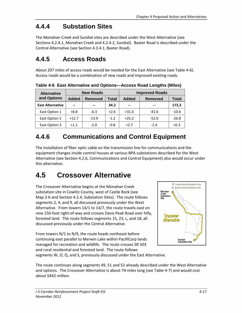
4.5 Crossover Alternative
The Crossover Alternative begins at the Monahan Creek substation site in Cowlitz County, west of Castle Rock (see Map 2-6 and Section 4.2.4, Substation Sites). The route follows segments 2, 4, and 9, all discussed previously under the West Alternative. From towers 14/1 to 14/7, the route travels east on new 150-foot right-of-way and crosses Davis Peak Road over hilly, forested land. The route follows segments 15, 23, L, and 18, all discussed previously under the Central Alternative.
From towers N/1 to N/9, the route heads northeast before continuing east parallel to Merwin Lake within PacifiCorp lands managed for recreation and wildlife. The route crosses SR 503 and rural residential and forested land. The route follows segments W, O, Q, and S, previously discussed under the East Alternative.
The route continues along segments 49, 51 and 52 already described under the West Alternative and options. The Crossover Alternative is about 74 miles long (see Table 4-7) and would cost about $442 million.
Chapter 4 Proposed Action and Alternatives
4-18 I-5 Corridor Reinforcement Project Draft EIS November 2012
Table 4-7 Crossover Alternative and Options—Line Lengths (Miles)
Alternative and Options Added Removed Total
Crossover Alternative -- -- 74.0
Crossover Option 1 +7.3 -2.1 +5.2
Crossover Option 2 +4.3 -- +4.3
Crossover Option 3 +4.2 -- +4.2
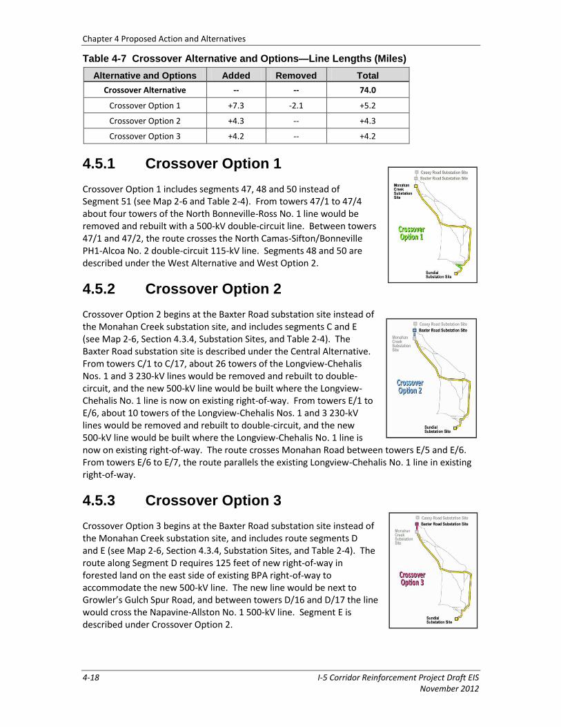
4.5.1 Crossover Option 1
Crossover Option 1 includes segments 47, 48 and 50 instead of Segment 51 (see Map 2-6 and Table 2-4). From towers 47/1 to 47/4 about four towers of the North Bonneville-Ross No. 1 line would be removed and rebuilt with a 500-kV double-circuit line. Between towers 47/1 and 47/2, the route crosses the North Camas-Sifton/Bonneville PH1-Alcoa No. 2 double-circuit 115-kV line. Segments 48 and 50 are described under the West Alternative and West Option 2.
4.5.2 Crossover Option 2
Crossover Option 2 begins at the Baxter Road substation site instead of the Monahan Creek substation site, and includes segments C and E (see Map 2-6, Section 4.3.4, Substation Sites, and Table 2-4). The Baxter Road substation site is described under the Central Alternative. From towers C/1 to C/17, about 26 towers of the Longview-Chehalis Nos. 1 and 3 230-kV lines would be removed and rebuilt to double-circuit, and the new 500-kV line would be built where the Longview-Chehalis No. 1 line is now on existing right-of-way. From towers E/1 to E/6, about 10 towers of the Longview-Chehalis Nos. 1 and 3 230-kV lines would be removed and rebuilt to double-circuit, and the new 500-kV line would be built where the Longview-Chehalis No. 1 line is now on existing right-of-way. The route crosses Monahan Road between towers E/5 and E/6. From towers E/6 to E/7, the route parallels the existing Longview-Chehalis No. 1 line in existing right-of-way.
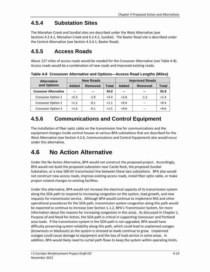
4.5.3 Crossover Option 3
Crossover Option 3 begins at the Baxter Road substation site instead of the Monahan Creek substation site, and includes route segments D and E (see Map 2-6, Section 4.3.4, Substation Sites, and Table 2-4). The route along Segment D requires 125 feet of new right-of-way in forested land on the east side of existing BPA right-of-way to accommodate the new 500-kV line. The new line would be next to Growler’s Gulch Spur Road, and between towers D/16 and D/17 the line would cross the Napavine-Allston No. 1 500-kV line. Segment E is described under Crossover Option 2.
Chapter 4 Proposed Action and Alternatives
I-5 Corridor Reinforcement Project Draft EIS 4-19 November 2012
4.5.4 Substation Sites
The Monahan Creek and Sundial sites are described under the West Alternative (see Sections 4.2.4.1, Monahan Creek and 4.2.4.2, Sundial). The Baxter Road site is described under the Central Alternative (see Section 4.3.4.1, Baxter Road).
4.5.5 Access Roads
About 127 miles of access roads would be needed for the Crossover Alternative (see Table 4-8). Access roads would be a combination of new roads and improved existing roads.
Table 4-8 Crossover Alternative and Options—Access Road Lengths (Miles)
Alternative and Options
New Roads Improved Roads
Added Removed Total Added Removed Total
Crossover Alternative -- -- 34.0 -- -- 92.8
Crossover Option 1 +5.3 -1.9 +3.4 +2.6 -1.2 +1.4
Crossover Option 2 +1.2 -0.1 +1.1 +9.4 -- +9.4
Crossover Option 3 +1.6 -0.1 +1.5 +9.6 -- +9.6
4.5.6 Communications and Control Equipment
The installation of fiber optic cable on the transmission line for communications and the equipment changes inside control houses at various BPA substations that are described for the West Alternative (see Section 4.2.6, Communications and Control Equipment) also would occur under this alternative.
4.6 No Action Alternative
Under the No Action Alternative, BPA would not construct the proposed project. Accordingly, BPA would not build the proposed substation near Castle Rock, the proposed Sundial Substation, or a new 500-kV transmission line between these two substations. BPA also would not construct new access roads, improve existing access roads, install fiber optic cable, or make project-related changes to existing facilities.
Under this alternative, BPA would not increase the electrical capacity of its transmission system along the SOA path to respond to increasing congestion on the system, load growth, and new requests for transmission service. Although BPA would continue to implement RAS and other operational procedures for the SOA path, transmission system congestion along this path would be expected to continue to increase (see Section 1.1.2, BPA’s Transmission System, for more information about the reasons for increasing congestion in this area). As discussed in Chapter 1, Purpose of and Need for Action, the SOA path is critical in supporting Vancouver and Portland area loads. If the transmission system in the SOA path is not upgraded, BPA would have difficulty preserving system reliability along this path, which could lead to unplanned outages (brownouts or blackouts) as the system is stressed as loads continue to grow. Unplanned outages could cause damage to equipment and the loss of load service in some areas. In addition, BPA would likely need to curtail path flows to keep the system within operating limits,
Chapter 4 Proposed Action and Alternatives
4-20 I-5 Corridor Reinforcement Project Draft EIS November 2012
which would make it difficult for local utilities to schedule power to their customers. This could lead to the curtailment of load.
4.7 Alternatives Considered but Eliminated from Detailed Study
This section describes alternatives that were considered by BPA but eliminated from detailed study in this EIS. In developing this EIS, BPA has considered a number of potential alternatives to the action alternatives. These include alternatives developed by BPA and alternatives that either were suggested or responded to concerns raised during and after the scoping process for this EIS. For each potential alternative, BPA assessed whether the alternative was reasonable under NEPA and warranted further detailed evaluation in this EIS, or was unreasonable and should be eliminated from detailed study.
In determining which alternatives to evaluate further and which should be eliminated from detailed study, BPA considered whether the potential alternative would meet the identified need for the project and achieve the project’s purposes (see Section 1.3, Purposes). BPA also considered whether an alternative would have obvious, potentially greater adverse environmental effects than other alternatives. Because an almost unlimited number of alternatives could be created, BPA cannot consider in depth every conceivable alternative suggested. Consistent with CEQ guidance, BPA focused on evaluating a reasonable range of alternatives considering the purpose and need for the project, and environmental, technical, social, and economic factors. In so doing, BPA has sought to ensure that the EIS contains a reasonable range of alternatives to permit a reasoned choice.
4.7.1 Non-Wires Alternative
BPA considered whether there could be a solution to the project need that would not require the construction of a transmission line, otherwise referred to as a “non-wires” alternative. As described in Section 1.1.2.2, Reliability and Non-Wires Measures, BPA has historically used a non-wires measure called RAS to maintain reliability in emergency situations and maximize use of existing SOA path facilities. However, continuing to use RAS for this path is becoming more difficult and less effective as the local economy and population grow.
BPA contracted with Energy and Environmental Economics, Inc. (E3), to conduct a screening study of possible non-wires measures for the I-5 project (see Section 1.1.2.2, Reliability and Non-Wires Measures). The possible non-wires measures identified in E3’s studies for consideration included the following:
Energy efficiency—increasing efficiency of existing buildings or appliances to reduce electricity use
Demand response—managing when power is used at its source
Distributed generation—using small diesel generators or solar power at or close to the source of load
Generation redispatch—changing which large generation source(s) serves the load
Chapter 4 Proposed Action and Alternatives
I-5 Corridor Reinforcement Project Draft EIS 4-21 November 2012
E3’s studies determined that these non-wires measures potentially could defer the need for the proposed new line for up to a few years. However, these measures could not eliminate the need for this new line. The following discussion summarizes the key findings of the E3 studies related to each of the potential non-wires measures. E3’s studies are available on the project website: http://www.bpa.gov/corporate/I-5-EIS/documents.cfm.
The energy efficiency measures considered in E3’s studies would increase the efficiency of existing buildings and electrical appliances, and reduce electricity use in the metro area during summer peak periods. The Northwest Power and Conservation Council’s (NWPCC) Sixth Power Plan identifies energy efficiency targets and measures (such as the recent partnership with North Pacific Paper Corporation), which are then evaluated and verified through the NWPCC’s Regional Technical Forum. Examples of measures include the installation of more efficient cooling systems, insulation, electronic equipment power save modes, and lighting controls. BPA considered working with local utilities to accelerate the installation of measures that would most directly reduce summer peak power demand. The measures would have been installed in residential, commercial, and industrial facilities in the metro area and service territories of Clark Public Utilities, PGE, and PacifiCorp, and would have required agreements and cooperation from these utilities.
Demand response is a way to manage the amount of power that is being used at its source. E3 studied demand response through direct local control — where devices would be placed on water heaters or air conditioners in the metro area so they automatically turn off or are turned down during high peak times to lessen the need for power. E3’s studies also considered demand response through adjusting electrical rates to make them more expensive during peak times (summer daytime during the week), so users are motivated to postpone electrical use for non-peak hours (e.g., doing laundry in the evenings or on weekends).
For distributed generation, small generators are used at the source of need or load, such as solar panels on a house or business, or diesel generators at buildings, grocery stores, or local utility substations (these diesel generators are often used as back-up emergency generators). These generators could be switched on by a central system operator during summer peak load to help serve local power needs, reducing the amount of power that would need to flow over the SOA path from the north. Distributed generation would be required 5 to 20 days per year, depending on the weather. Local utilities in the Portland area have a number of distributed generators installed. However, BPA would likely be unable to use these existing generators because the number of hours and days they can be used are highly regulated, and these generators are used by local utilities, often for the same reasons and during the same time frames that BPA would need them. The installation of new generators, which would be used on hot summer days when air quality concerns are greatest, may be inconsistent with BPA’s overall environmental objectives because of air quality impacts.
Based on the numbers from E3’s report, the combined impact from these non-wires measures (energy efficiency, distributed generation, and demand response) is relatively small. By 2016 (when the existing transmission system’s capacity is likely to be reached), the cumulative effect of these measures is estimated to be only about 5 percent of the forecasted total load for the metro area. This amount is insufficient for long-term congestion relief on the SOA path.
Generation redispatch would require turning off large generators located north of the metro area, while turning on generators located south of the metro area to reduce the power flow on SOA. Generally, this would allow loads in the metro area to be served from the south or east,
Chapter 4 Proposed Action and Alternatives
4-22 I-5 Corridor Reinforcement Project Draft EIS November 2012
and power serving loads in California would not have to flow through the area. E3’s studies showed that generation redispatch could offer the greatest relief to the SOA path and would only need to be implemented 5 to 20 days per year. However, generation redispatch could only potentially help defer the I-5 Project’s energization date for 2 to 6 years.
Overall, the non-wires studies revealed that even with aggressive implementation of all four non-wires measures, the amount of power reduced on the SOA path would not be enough to meet the need after 2020. Also, as described in Section 1.1.2.2, Reliability and Non-Wires Measures, the studies did not address the commercial requests for new transmission service on the SOA path. Because the Non-Wires Alternative would not meet the need for the project, it was eliminated from further study as a long-term solution. However, since generation redispatch may help delay a new line energization date by 2 to 6 years, BPA is continuing to separately analyze the operational and commercial feasibility of generation redispatch to help maintain short-term system reliability (see Section 1.1.2.2, Reliability and Non-Wires Measures).
4.7.2 Transmission Line Routing Alternatives
4.7.2.1 Alternate Routes from Castle Rock, Washington to near Wilsonville, Oregon (Pearl Routes)
Early in the project planning process, BPA considered a number of potential transmission line routes that extended from the Castle Rock area generally south to BPA’s existing Pearl Substation near Wilsonville, Oregon (Pearl Routes). These routes were divided into over 40 route segments. BPA reviewed these routes and found they had several constraints that affected the reasonableness of using these segments for a new transmission line route.
No existing BPA right-of-way was vacant and available for any of the segments in the proposed Pearl Routes. All Pearl Route segments would require new rights-of-way through rural and heavily populated areas in Washington and Oregon, and would likely require removing private homes, significantly increasing projects costs and social impacts.
The Pearl Routes also would require a new Columbia River crossing near Longview, Washington with much different conditions than the proposed crossing into Troutdale, Oregon. For example, it would require a new crossing with new marine and air transportation safety issues as compared with alternatives that use the existing Columbia River crossing. At the location needed for the Pearl Routes, the river is wide and new towers would need to be much higher, possibly over 400 feet tall—more than twice the height of standard 500-kV towers. In addition, towers would be located on islands currently managed for wildlife habitat. Environmental impact to wildlife species, habitat, and visual resources could be high at this crossing.
Pearl Substation is surrounded by mostly industrial buildings. Though there would be space to bring in a new 500-kV line, there is no space available for future expansions. BPA typically purchases additional space around substations for such expansions to prepare for potential future activities and development.
Although the Pearl Routes could address the transmission capacity issue, the inability of these routes to use any existing vacant transmission rights-of-way, the high social impacts of housing removal, the technical issues with a new Columbia River crossing, the likely higher environmental impacts, and the limitations at the Pearl Substation combined to make these
Chapter 4 Proposed Action and Alternatives
I-5 Corridor Reinforcement Project Draft EIS 4-23 November 2012
routes not reasonable alternatives. These routes, therefore, were considered but eliminated from detailed study in this EIS.
4.7.2.2 Castle Rock to Troutdale Route Segments
In December 2009, 52 route segments were proposed for the transmission line (see Chapter 2 and Map 2-1). In response to public input and further BPA study, the following segments were partially or wholly eliminated from consideration for the following reasons.
Segments 10 and 6: The northern half of Segment 10 was eliminated from consideration due to prohibitively steep terrain and proximity to homes (compared to northern portion of Segment 11). Segment 6 was originally selected to connect to the northern half of Segment 10. Because that portion of Segment 10 was eliminated from consideration, Segment 6 was no longer needed and was also eliminated from consideration.
Segment 11: The southern half of Segment 11 crossed steep terrain, went through two parks/recreation areas at Merwin Lake including campgrounds, proceeded through a large old growth timber stand important to bald eagles, went through spotted owl habitat and would be visible to the recreation areas and many homes. The lower portion of Segment 11 was replaced with Segment K.
Segment 13: This segment was originally located as a more direct route to Segment 17. Segment 13 is on WDNR and Weyerhaeuser land, and crosses very steep terrain with no homes nearby. Segment 13 crossed near Davis Mountain on WDNR property where a cluster of communication towers could be affected by high-voltage interference. Segment 13 has steep terrain and slopes greater than 35 percent that would increase construction costs and negatively impact WDNR’s timber harvest practices by blocking access to large areas down slope outside of the potential right-of-way locations. BPA determined Segment 12 could instead be used to reach middle and far eastern routes, because it crosses gentler terrain and would create fewer impacts to logging practices than Segment 13. Segment 13 was eliminated from consideration.
Segment 17: This segment is almost entirely located on PacifiCorp land and crosses the Lewis River just above and upstream of Merwin Dam. It was originally included to provide a direct route to Segment 26 and to take advantage of Segment 13’s more direct path. Segment 17 is in direct view of the popular Merwin Dam recreation area and crosses critical wildlife habitat on the south side of the reservoir where old-growth trees provide bald eagle habitat and structure for a known osprey nest. With Segment 13 removed from analysis, and because of potential impacts to wildlife and recreation, Segment 17 was eliminated from further consideration.
Segment 16: Segment 16 runs parallel to an existing PacifiCorp transmission line. It was originally located to connect segments 12 and 15 to Segment 17. Because Segment 17 was dropped from consideration, Segment 16 was no longer needed and was eliminated from further consideration.
Segment 24: This Segment was initially proposed as a means of connecting Segment 17 to Segment 26. Because Segment 17 was eliminated from consideration, Segment 24 was also eliminated from further consideration.
Segments 19, 20, 21, and 22: These four segments were modified into Segment N.
Chapter 4 Proposed Action and Alternatives
4-24 I-5 Corridor Reinforcement Project Draft EIS November 2012
Segments 29, 32, 33, and 34: In response to public input, Segment 29 was eliminated from further consideration as the easternmost segment, and Segment O was developed farther east away from homes. Segments 32, 33, and 34 were eliminated from further consideration because new segments O and P were developed. Segments O and P were located to mostly follow property and section lines to minimize potential impacts to logging practices, affect fewer recreation resources, and avoid a potential wind generation area.
Segments 28, 30 and 35: Portions of segments 28, 30, and 35 were eliminated from consideration because the segments to which they were connected had changed and those portions were no longer needed. The newer segments Q, R, S, and T allowed new segments P and O to connect back to the Sundial substation site.
Segments 27, 31, 42, and 44: These four segments used an existing PacifiCorp right-of-way that was suggested to BPA early in the process. Upon investigation, however, BPA discovered that this existing right-of-way is only 100 feet wide along these segments. These segments also cross a developed community, and many homes have been built up to the edge of the existing right-of-way and some homes are within the existing right-of-way at many locations. Because a 150-foot-wide right-of-way is required for the project, BPA would have needed to buy an additional 50 feet of right-of-way to use those segments, which would have required removing many homes. For this reason, those segments were eliminated from further consideration.
4.7.2.3 Reconfigure Existing 500-kV lines near Longview, Washington
BPA received a suggestion to separate existing 500-kV lines that are now parallel to each other in the Longview, Washington area and across the Columbia River. Under this alternative, BPA would increase the separation between the existing parallel 500-kV lines in the Longview area and at the existing Columbia River multi-line crossing at Longview so that they could be allowed to operate at full capacity (which varies by season and operating patterns). The suggestion stated that this realignment could help relieve congestion in the Longview vicinity, eliminate the need for a new substation at Castle Rock, and allow BPA to move the northern end of the transmission line to BPA’s existing Allston Substation in Oregon and reconsider the route to Pearl Substation (see Section 4.7.2.1, Alternate Routes from Castle Rock, Washington to near Wilsonville, Oregon [Pearl Routes]).
Separating the existing 500-kV lines would require extensive reconfiguration, including tearing down a set of existing towers, foundations, and conductors for about 12 miles from Castle Rock to the Columbia River, and building a new set of 500-kV towers, foundations and conductors with added line crossings, transition towers, and line swapping. This alternative also would require extensive work at the Columbia River crossing at Longview, Washington. To create adequate separation distance between the 500-kV transmission lines, a new river crossing about 3,000 feet downstream would be needed. This crossing would have similar impacts as the river crossing described for the Pearl Routes (see Section 4.7.2.1, Alternate Routes from Castle Rock, Washington to near Wilsonville, Oregon [Pearl Routes]). This reconfiguration would require six special towers and two new unique river crossing towers over 450 feet tall. BPA would need to design these non-standard towers for the specific location and height. This would require extensive design work, and unique towers for which no backup tower or replacement tower
Chapter 4 Proposed Action and Alternatives
I-5 Corridor Reinforcement Project Draft EIS 4-25 November 2012
would be available. The environmental and visual impacts of this option would be greater than under the action alternatives.
The operating limit of this alternate path would be lower when compared to the direct routes proposed from Castle Rock to Troutdale. The only way to achieve a comparable operating limit would be to reconfigure the existing 230-kV lines in the Longview vicinity and build a new 230-kV line into Longview Substation, in addition to the extensive work already described.
Although this alternative could eliminate the need for a new Castle Rock substation, Allston Substation would still need to be expanded to accommodate a new 500-kV line to Pearl Substation. The expansion would require new right-of-way in an area that does not have vacant right-of-way available. Any route originating at Allston Substation would need to connect to Pearl Substation. However, the routes to Pearl Substation were determined not to be reasonable alternatives and were eliminated from further consideration (see Section 4.7.2.1, Alternate Routes from Castle Rock, Washington to near Wilsonville, Oregon [Pearl Routes]). For these reasons, this alternative was eliminated from further consideration.
4.7.2.4 Northeastern Alternative, North of Silver Lake, Washington
Several comments suggested using a transmission line route heading east from the proposed Casey Road substation site north of Silver Lake, Washington, then heading south to Troutdale, Oregon. Comments suggested that this alternative would reduce impacts to private landowners and homes. BPA conducted an initial evaluation of this suggestion in late 2010 and provided this analysis in a project update newsletter in February 2011 (available at the project website: www.bpa.gov/corporate/i-5-EIS/documents.cfm). Subsequently, BPA received additional, more specific comments and suggestions about developing this route and decided to study the suggestion in more detail.
Over several months, BPA studied this route using public input, aerial photography, helicopter reconnaissance, field trips, and meetings with public and private owners of large timberland parcels and affected utilities. After careful study, BPA concluded that although this route may relieve one set of landowners from impacts, it would affect a new population of landowners instead, particularly just east of Cougar, and to some degree north of Castle Rock along the Cowlitz River. In addition, this route would be longer (10 to 15 miles), cross very steep terrain, require more miles of new access roads, and constrain timber management/harvests. It could also impact critical habitat for endangered species and wetlands.
Impact tradeoffs between the suggested route and already proposed routes tend to generally be the same, and for some project components such as cost, constructability, and the environment, this suggested route would likely have greater impacts than the action alternatives because of its length and the terrain it would cross. For these reasons, this alternative was eliminated from further consideration (see Evaluation of Northeastern I-5 Route at: www.bpa.gov/corporate/I-5-EIS/documents/Decision-northeastern-route-Jan2012.pdf).
4.7.2.5 Interstate 5 Highway Median Alternative
Several comments suggested that the I-5 freeway median be used to accommodate the new line. BPA engineers considered this suggestion. The median is extremely narrow in most areas, with little or no room to accommodate 500-kV towers or a 150-foot right-of-way. Due to
Chapter 4 Proposed Action and Alternatives
4-26 I-5 Corridor Reinforcement Project Draft EIS November 2012
extensive development along much of the freeway, there is no path available from the freeway to connect to any other existing transmission line corridor or segment. To build a 500-kV transmission line in the median, BPA would have to obtain rights from the Federal Highway Administration (FWHA) to use the land, and also schedule traffic closures to build and maintain the line. In general, FHWA seeks to accommodate utility facilities within the rights-of-way of federal highways such as I-5, when such use and occupancy of the highway right-of-way do not adversely affect highway or traffic safety, or otherwise impair the highway or its aesthetic quality, and do not conflict with the provisions of federal, state or local laws or regulations (see 23 CFR 645 subpart B). The new transmission towers would create a new safety hazard for motorists and potentially aircraft, and interfere with future highway expansion. For these reasons, BPA eliminated this alternative from consideration.
4.7.2.6 Trojan Nuclear Plant Facilities
During the scoping period, BPA received comments that suggested using existing facilities including transmission lines that were constructed for PGE’s Trojan Nuclear Plant in Rainier, Oregon.
Though PGE decommissioned and removed the Trojan Nuclear Plant, PGE essentially replaced the resource with an equivalent amount of thermal generating plants owned and operated by PGE to serve their local load. PGE added a gas-fired generation plant (Port Westward) in 2007, and has an existing gas-fired generator (Beaver), both interconnected at Trojan. Together, both facilities have a combined output of about 900 MW of generation. The facilities in this area are still used to transport power to loads. PGE’s generation near Trojan Substation reaches loads in Longview, Washington through two of PGE’s 230-kV lines that are connected to BPA’s Allston Substation. The PGE 230-kV lines are critical transmission lines, serving loads in the Portland/Vancouver metro area. Because the lines that connect to Trojan Substation are owned by PGE, and because they are already being used, this alternative was eliminated from further consideration.
4.7.2.7 Transmission Line Routes Bordering U.S. Forest Service and WDNR Land East of the Project Area
BPA considered line routes bordering U. S. Forest Service (USFS) Gifford Pinchot National Forest and WDNR land east of Segment O, which was added in August 2010 in response to requests to develop a route farther east. These routes are less reasonable when compared to Segment O. Segment O was proposed after discussions with large landowners such as Weyerhaeuser, Longview Timber, USFS, and WDNR. Routing options farther east than Segment O would cross the Silver Star Scenic Area (Gifford Pinchot National Forest), a popular recreation area near Silver Star Mountain; be longer; cross prohibitively steep terrain; require more turns and dead-end towers to stay close to the WDNR/USFS border; and require longer access roads in an area with limited accessibility and poor road conditions during winter. These routing options would also cross land designated or proposed for roadless areas. These lands could also be designated as wilderness areas in the future. For these reasons, BPA eliminated this alternative from consideration.
4.7.2.8 Transmission Line Route East to Bonneville Dam
During the scoping process, several comments suggested routing a line farther east from Castle Rock to a location near Bonneville Dam in the Columbia River Gorge. A route that could
Chapter 4 Proposed Action and Alternatives
I-5 Corridor Reinforcement Project Draft EIS 4-27 November 2012
adequately reinforce the project area from a Castle Rock substation site to Bonneville Dam would be at least 99 miles long, much longer than any route currently under consideration. Because the load center is not in the Bonneville Dam area, BPA would still have to build a new line back to either Troutdale or Ostrander substations, which would add another 24 to 32 miles of line. The additional line length would increase construction and operation costs, and would reduce technical performance. With a Bonneville Dam route, a loss of about 350 MW of capacity could be expected because of the longer route. Series compensation could recover some of the lost capacity (at additional cost), but this alternative would shorten the time before the next major reinforcement was needed in the area.
A route from Bonneville Dam to the Troutdale area would also require building a portion of the line through the Columbia River Gorge National Scenic Area (NSA), an area of federally protected land managed by the USFS. The area is valued for its scenery and recreational opportunities. This alternative was eliminated due to the added cost needed for additional transmission line length, and reduced capacity and diminished technical performance.
4.7.3 Lower Voltage Line Upgrades
BPA considered upgrading lower voltage lines to meet the need for the project. The cumulative amount of required line upgrades needed to adequately reinforce the system exceeds 200 miles and would require upgrades to lines beyond BPA’s jurisdiction that are owned by other utilities. Some of the lines that would need upgrades are already high-capacity lines and would require bundled conductors (more than one conductor per phase of the line) to increase the capacity further. Because adding more wires per phase would make the line heavier, it would likely require completely rebuilding the line with stronger towers to support the bundled conductors. Ultimately, upgrading existing lines would not provide the voltage support that the current proposal provides and could result in much higher costs because of the miles of line that would need to be upgraded. For these reasons, upgrading lower voltage transmission lines was eliminated from further consideration.
4.7.4 Reynolds Aluminum Plant Facilities
During the scoping period, BPA received comments that suggested using existing transmission facilities that served the Reynolds Aluminum plant in Longview, Washington. The Reynolds Aluminum plant closed several years ago and equipment has been removed from the site. The plant’s closure provided some relief for the need to reinforce the transmission system in the Longview/Vancouver/Portland area. However, load growth (more people moving into the area and increased installation and use of air conditioning) is expected to use up the available capacity by 2016 (see Chapter 1, Purpose of and Need for Action). Because this available capacity could not meet the need for the project, this suggestion was eliminated from further consideration.
4.7.5 High Voltage Direct Current (HVDC) Technology
Some commentors suggested using HVDC technology for the entire line instead of the High Voltage Alternating Current (HVAC) 500-kV line proposed. HVDC is generally used to move large amounts of power over long distances. HVAC lines used over long distances need to be heavily compensated, that is, have devices such as capacitors or voltage regulators to improve
Chapter 4 Proposed Action and Alternatives
4-28 I-5 Corridor Reinforcement Project Draft EIS November 2012
performance of the system, and that could be more expensive. However, HVDC is also expensive because it would require DC terminals at each end of a line, which are also expensive. Because of these competing costs, HVDC is generally used when the length of the line (in kilometers) exceeds the voltage of the line (in kilovolts), which is a general guideline that accounts for these costs. In our case, the line length (about 120 kilometers) is much less than the 500 kilovolts needed for the line and so this project does not meet this general guideline.
HVDC is a reliable tool for transmitting power over long distances, but because of its prohibitively high cost for the length of the proposed project, and because BPA would still need to build a transmission line with similar impacts as the proposed project, it is not considered a reasonable alternative and was eliminated from further consideration.
4.7.6 Columbia River Underwater Alternative
Some comments suggested using underwater cables for the whole length of the line from Longview, Washington to Troutdale, Oregon or just across the Columbia River where the proposed project crosses from Washington into Oregon. Underwater cables are often considered where an overhead route is impossible, such as for long water crossings. For example, BPA’s uses 2- and 5-mile sections of 115-kV alternating current underwater transmission cables in the San Juan Islands. Underwater cables are required because there is no ability to string overhead lines across the water.
For this project, we have several overhead route options, including one on mostly existing BPA right-of-way. For the Columbia River crossing, we have the opportunity to locate the new line among existing overhead transmission lines in an existing utility corridor, with an island in the middle that makes the span lengths between towers reasonable and relatively short.
Manufacturing and installing underwater cable in the Columbia River would cost several times more than going overhead. In addition, if damage or failure occurs, since the line is buried underwater and cannot be inspected directly, it can be difficult and time consuming to determine where the problem has occurred and the length of damaged cable. Uncovering and replacing the buried submarine cable is a specialized process and takes much longer than repairing an overhead line. For these reasons, outages on buried submarine cables tend to be much longer and can compromise the reliability of the system.
There are environmental tradeoffs also. With overhead lines, towers can typically be placed 1,000 to 1,500 feet apart and can span sensitive natural or manmade areas. Burying submarine cables requires continuous trenching and continuous access, resulting in potentially more impacts to the environment. The line would be located in parts of the river where large ships can disturb the river bottom with their propellers and prop wash, and in areas where dredging is done on a regular basis to accommodate ship traffic. Both issues make it risky and difficult to locate and bury a cable deep enough to avoid damage from ships or dredging, and yet not so deep that it cannot be removed and replaced in the future should a problem occur. Locating outside the ship traffic and dredging area involves disturbing sensitive riparian and wildlife habitat along the shore.
Placing one or more portions of the 70-mile new line under water would have the same reliability and environmental issues, plus higher per mile cost due to the initial design and set-up requirements for manufacturing a shorter length of cable. In addition, expensive transition facilities would be required at each end of any section of submarine cable. For these cost,
Chapter 4 Proposed Action and Alternatives
I-5 Corridor Reinforcement Project Draft EIS 4-29 November 2012
reliability and environmental reasons, placing the transmission line underwater has been considered but eliminated from detailed study in this EIS.
4.7.7 Undergrounding the Transmission Line
During the scoping process, comments suggested burying the new transmission line underground either for its entire length or for certain lengthy portions such as through the Camas and Washougal areas. In response to scoping comments, BPA updated its information about the technical requirements and feasibility, and potential environmental impacts of using an underground cable system for its high-voltage transmission line projects (see Appendix D). This section summarizes the information contained in Appendix D.
Underground distribution cables of lower voltage are fairly common, but underground transmission cables of higher voltage such as that needed for the proposed project are not. In addition, underground high-voltage transmission cables typically are used only for relatively short distances in areas where it is physically impossible to install towers for overhead transmission lines. BPA is not aware of any instances where a utility has placed a transmission line of the proposed project’s length and voltage (i.e., 70 miles of 500-kV line) underground.
There are several reasons why underground transmission lines of this length and voltage have not been built. The cost of underground is typically 10 to 20 times more expensive than overhead lines. It is also difficult to keep high voltage underground transmission cables from overheating. When they get overloaded and overheat, the insulation material used can breakdown quickly and cause a failure at the time of overheating, or later from damage caused by overheating. Since the line is buried and cannot be inspected directly, it can be difficult and time consuming to determine where the damage has occurred and the length of damaged cable. Uncovering and replacing the buried cable is a specialized process and can take much longer than repairing an overhead line. For these reasons, outages on underground cables tend to be much longer and can compromise the reliability of the system.
There are environmental tradeoffs also. With overhead lines, towers can typically be placed 1,000 to 1,500 feet apart and can span sensitive natural or manmade areas. Placing lines underground requires continuous trenching and a continuous access road system, resulting in potentially more impacts to the environment.
Placing portions of the 70-mile new line underground would have the same reliability and environmental issues, plus higher per mile cost due to the initial design and set-up requirements for manufacturing a shorter length of cable. In addition, expensive transition facilities would be required at each end of any section of underground. For these cost, reliability and environmental reasons undergrounding the transmission line has been considered but eliminated from detailed study in this EIS.
4.8 Comparison of Alternatives
BPA has evaluated the action alternatives and the No Action Alternative, and has compared the alternatives based on the information found in the chapters and appendices in this EIS. The results of the comparison are summarized in Tables 4-9, 4-10, and 4-11.
All action alternatives (West, Central, East, and Crossover and their options) would meet the need for the project; the No Action Alternative would not.
Chapter 4 Proposed Action and Alternatives
4-30 I-5 Corridor Reinforcement Project Draft EIS November 2012
4.9 Preferred Alternative
BPA has evaluated the alternatives and options, considered the purpose of and need for the proposed project, the affected environment, and environmental consequences, and based on these factors, BPA’s preferred alternative at this time is the Central Alternative, using Central Option 1.
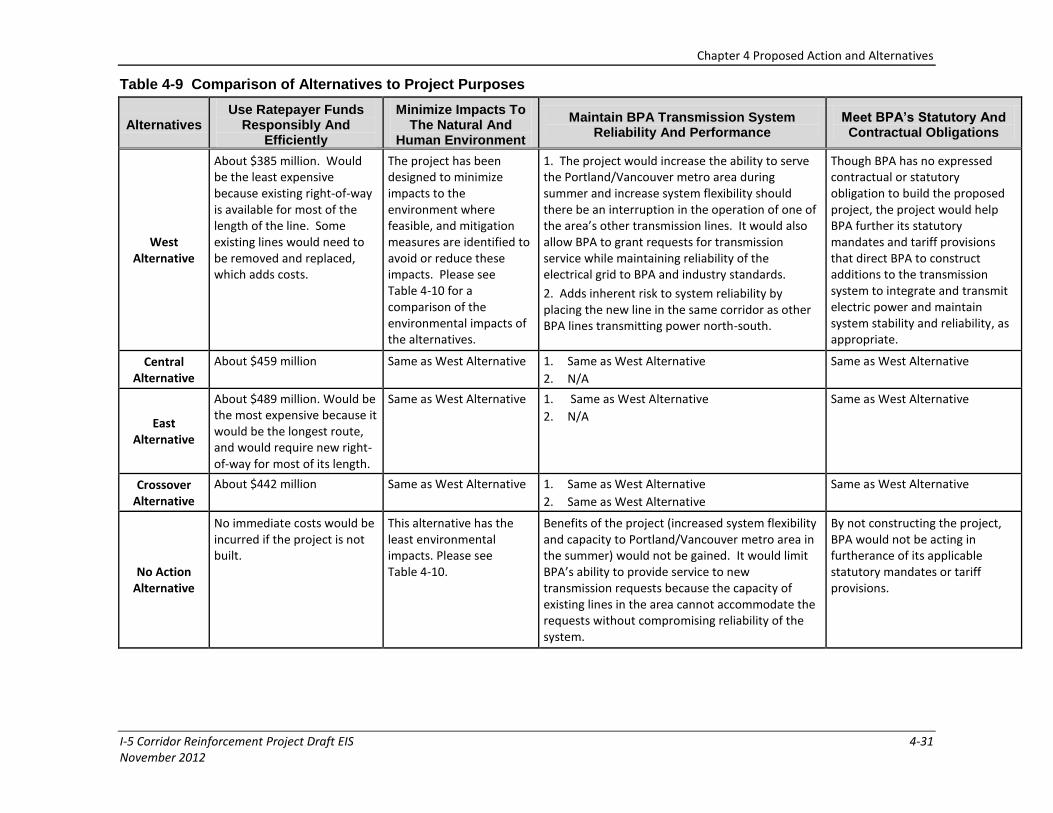
Chapter 4 Proposed Action and Alternatives
I-5 Corridor Reinforcement Project Draft EIS 4-31 November 2012
Table 4-9 Comparison of Alternatives to Project Purposes
Alternatives Use Ratepayer Funds
Responsibly And Efficiently
Minimize Impacts To The Natural And
Human Environment
Maintain BPA Transmission System Reliability And Performance
Meet BPA’s Statutory And Contractual Obligations
West Alternative
About $385 million. Would be the least expensive because existing right-of-way is available for most of the length of the line. Some existing lines would need to be removed and replaced, which adds costs.
The project has been designed to minimize impacts to the environment where feasible, and mitigation measures are identified to avoid or reduce these impacts. Please see Table 4-10 for a comparison of the environmental impacts of the alternatives.
1. The project would increase the ability to serve the Portland/Vancouver metro area during summer and increase system flexibility should there be an interruption in the operation of one of the area’s other transmission lines. It would also allow BPA to grant requests for transmission service while maintaining reliability of the electrical grid to BPA and industry standards.
2. Adds inherent risk to system reliability by placing the new line in the same corridor as other BPA lines transmitting power north-south.
Though BPA has no expressed contractual or statutory obligation to build the proposed project, the project would help BPA further its statutory mandates and tariff provisions that direct BPA to construct additions to the transmission system to integrate and transmit electric power and maintain system stability and reliability, as appropriate.
Central Alternative
About $459 million Same as West Alternative 1. Same as West Alternative
2. N/A
Same as West Alternative
East Alternative
About $489 million. Would be the most expensive because it would be the longest route, and would require new right-of-way for most of its length.
Same as West Alternative 1. Same as West Alternative
2. N/A
Same as West Alternative
Crossover Alternative
About $442 million Same as West Alternative 1. Same as West Alternative
2. Same as West Alternative
Same as West Alternative
No Action Alternative
No immediate costs would be incurred if the project is not built.
This alternative has the least environmental impacts. Please see Table 4-10.
Benefits of the project (increased system flexibility and capacity to Portland/Vancouver metro area in the summer) would not be gained. It would limit BPA’s ability to provide service to new transmission requests because the capacity of existing lines in the area cannot accommodate the requests without compromising reliability of the system.
By not constructing the project, BPA would not be acting in furtherance of its applicable statutory mandates or tariff provisions.
Chapter 4 Proposed Action and Alternatives
4-32 I-5 Corridor Reinforcement Project Draft EIS November 2012
Page intentionally left blank
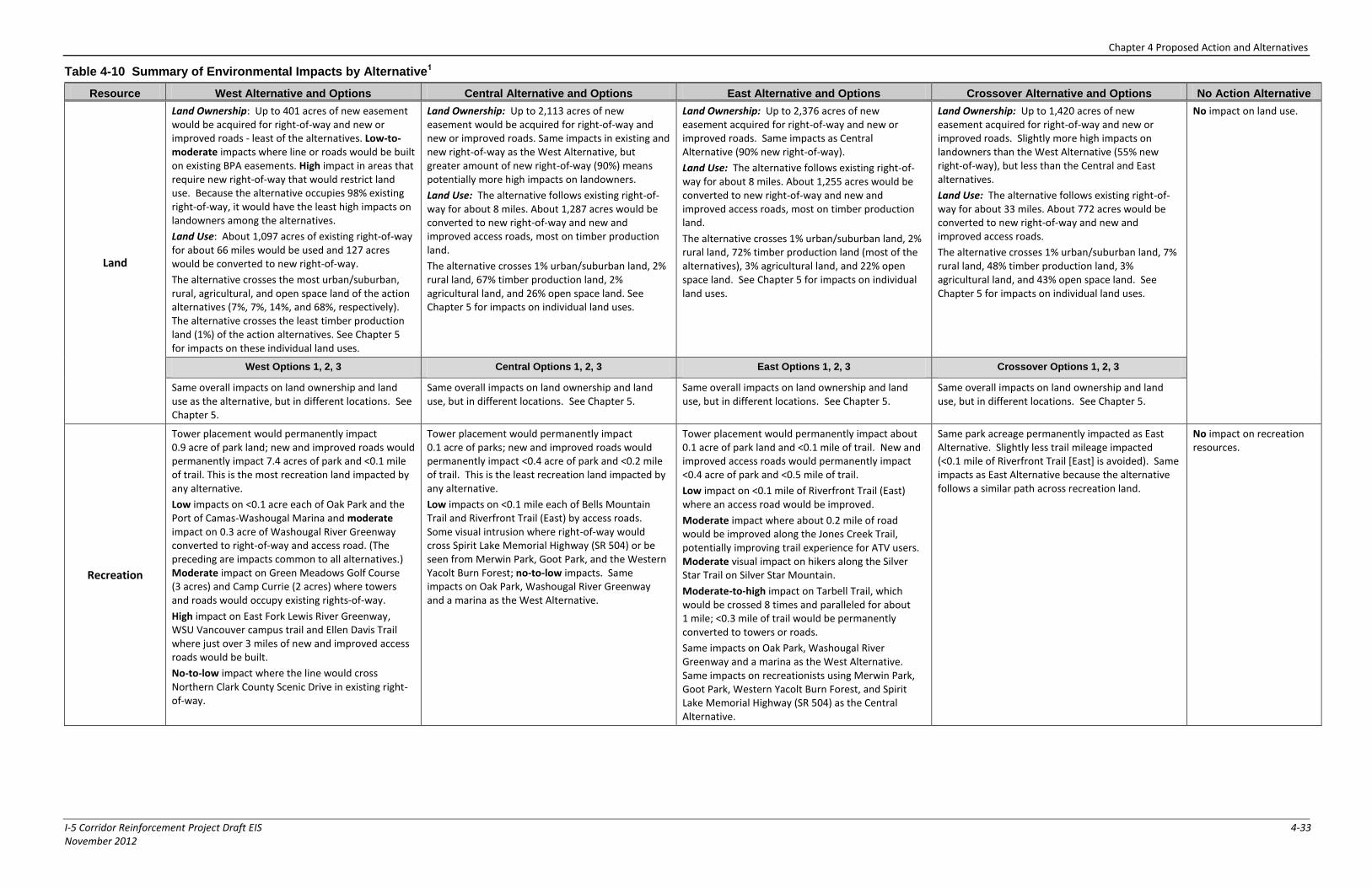
Chapter 4 Proposed Action and Alternatives
I-5 Corridor Reinforcement Project Draft EIS 4-33 November 2012
Table 4-10 Summary of Environmental Impacts by Alternative1
Resource West Alternative and Options Central Alternative and Options East Alternative and Options Crossover Alternative and Options No Action Alternative
Land
Land Ownership: Up to 401 acres of new easement would be acquired for right-of-way and new or improved roads - least of the alternatives. Low-to-moderate impacts where line or roads would be built on existing BPA easements. High impact in areas that require new right-of-way that would restrict land use. Because the alternative occupies 98% existing right-of-way, it would have the least high impacts on landowners among the alternatives.
Land Use: About 1,097 acres of existing right-of-way for about 66 miles would be used and 127 acres would be converted to new right-of-way.
The alternative crosses the most urban/suburban, rural, agricultural, and open space land of the action alternatives (7%, 7%, 14%, and 68%, respectively). The alternative crosses the least timber production land (1%) of the action alternatives. See Chapter 5 for impacts on these individual land uses.
Land Ownership: Up to 2,113 acres of new easement would be acquired for right-of-way and new or improved roads. Same impacts in existing and new right-of-way as the West Alternative, but greater amount of new right-of-way (90%) means potentially more high impacts on landowners.
Land Use: The alternative follows existing right-of-way for about 8 miles. About 1,287 acres would be converted to new right-of-way and new and improved access roads, most on timber production land.
The alternative crosses 1% urban/suburban land, 2% rural land, 67% timber production land, 2% agricultural land, and 26% open space land. See Chapter 5 for impacts on individual land uses.
Land Ownership: Up to 2,376 acres of new easement acquired for right-of-way and new or improved roads. Same impacts as Central Alternative (90% new right-of-way).
Land Use: The alternative follows existing right-of-way for about 8 miles. About 1,255 acres would be converted to new right-of-way and new and improved access roads, most on timber production land.
The alternative crosses 1% urban/suburban land, 2% rural land, 72% timber production land (most of the alternatives), 3% agricultural land, and 22% open space land. See Chapter 5 for impacts on individual land uses.
Land Ownership: Up to 1,420 acres of new easement acquired for right-of-way and new or improved roads. Slightly more high impacts on landowners than the West Alternative (55% new right-of-way), but less than the Central and East alternatives.
Land Use: The alternative follows existing right-of-way for about 33 miles. About 772 acres would be converted to new right-of-way and new and improved access roads.
The alternative crosses 1% urban/suburban land, 7% rural land, 48% timber production land, 3% agricultural land, and 43% open space land. See Chapter 5 for impacts on individual land uses.
No impact on land use.
West Options 1, 2, 3 Central Options 1, 2, 3 East Options 1, 2, 3 Crossover Options 1, 2, 3
Same overall impacts on land ownership and land use as the alternative, but in different locations. See Chapter 5.
Same overall impacts on land ownership and land use, but in different locations. See Chapter 5.
Same overall impacts on land ownership and land use, but in different locations. See Chapter 5.
Same overall impacts on land ownership and land use, but in different locations. See Chapter 5.
Recreation
Tower placement would permanently impact 0.9 acre of park land; new and improved roads would permanently impact 7.4 acres of park and <0.1 mile of trail. This is the most recreation land impacted by any alternative.
Low impacts on <0.1 acre each of Oak Park and the Port of Camas-Washougal Marina and moderate impact on 0.3 acre of Washougal River Greenway converted to right-of-way and access road. (The preceding are impacts common to all alternatives.) Moderate impact on Green Meadows Golf Course (3 acres) and Camp Currie (2 acres) where towers and roads would occupy existing rights-of-way.
High impact on East Fork Lewis River Greenway, WSU Vancouver campus trail and Ellen Davis Trail where just over 3 miles of new and improved access roads would be built.
No-to-low impact where the line would cross Northern Clark County Scenic Drive in existing right-of-way.
Tower placement would permanently impact 0.1 acre of parks; new and improved roads would permanently impact <0.4 acre of park and <0.2 mile of trail. This is the least recreation land impacted by any alternative.
Low impacts on <0.1 mile each of Bells Mountain Trail and Riverfront Trail (East) by access roads. Some visual intrusion where right-of-way would cross Spirit Lake Memorial Highway (SR 504) or be seen from Merwin Park, Goot Park, and the Western Yacolt Burn Forest; no-to-low impacts. Same impacts on Oak Park, Washougal River Greenway and a marina as the West Alternative.
Tower placement would permanently impact about 0.1 acre of park land and <0.1 mile of trail. New and improved access roads would permanently impact <0.4 acre of park and <0.5 mile of trail.
Low impact on <0.1 mile of Riverfront Trail (East) where an access road would be improved.
Moderate impact where about 0.2 mile of road would be improved along the Jones Creek Trail, potentially improving trail experience for ATV users. Moderate visual impact on hikers along the Silver Star Trail on Silver Star Mountain.
Moderate-to-high impact on Tarbell Trail, which would be crossed 8 times and paralleled for about 1 mile; <0.3 mile of trail would be permanently converted to towers or roads.
Same impacts on Oak Park, Washougal River Greenway and a marina as the West Alternative. Same impacts on recreationists using Merwin Park, Goot Park, Western Yacolt Burn Forest, and Spirit Lake Memorial Highway (SR 504) as the Central Alternative.
Same park acreage permanently impacted as East Alternative. Slightly less trail mileage impacted (<0.1 mile of Riverfront Trail [East] is avoided). Same impacts as East Alternative because the alternative follows a similar path across recreation land.
No impact on recreation resources.
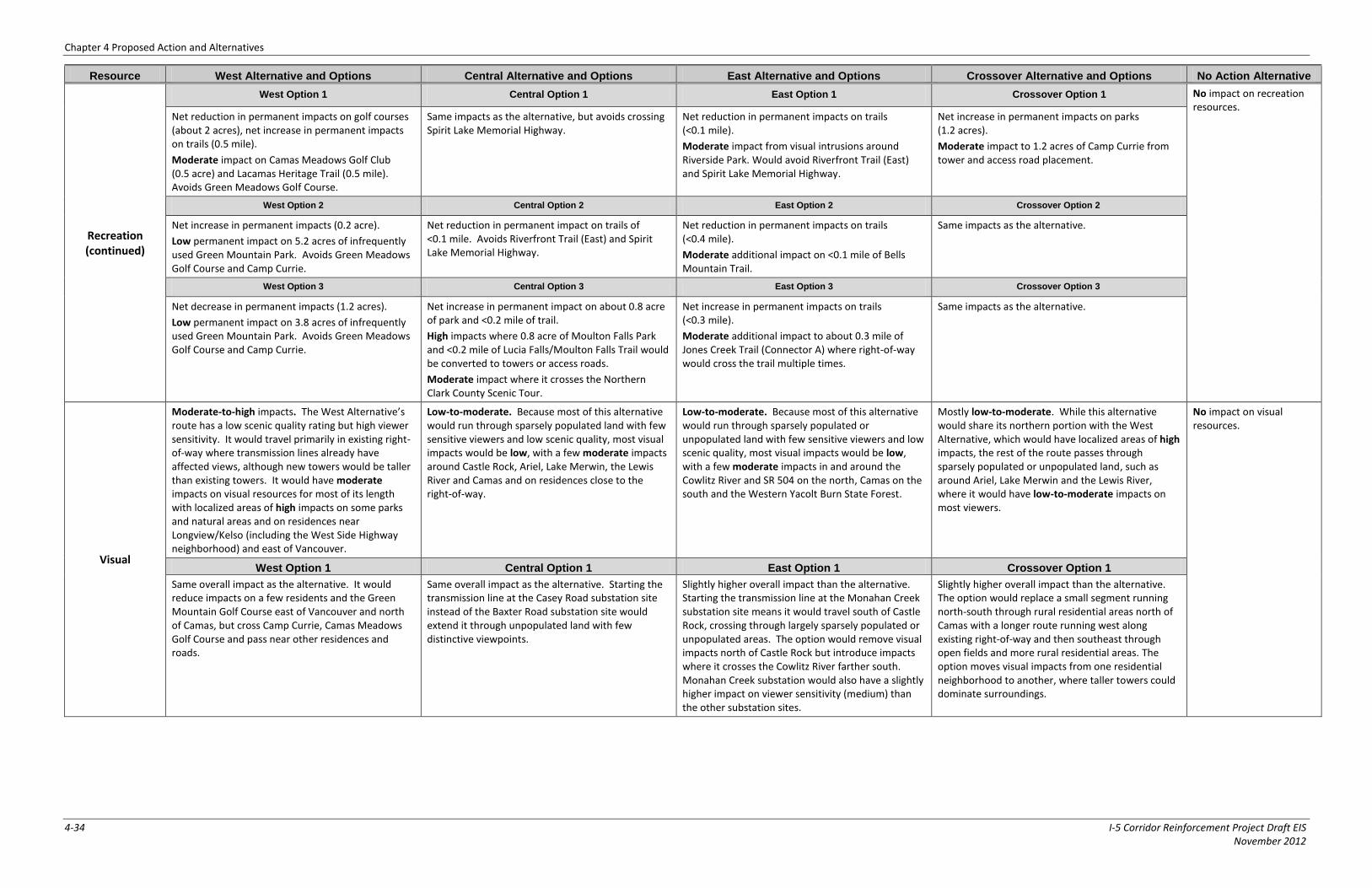
Chapter 4 Proposed Action and Alternatives
4-34 I-5 Corridor Reinforcement Project Draft EIS November 2012
Resource West Alternative and Options Central Alternative and Options East Alternative and Options Crossover Alternative and Options No Action Alternative
Recreation (continued)
West Option 1 Central Option 1 East Option 1 Crossover Option 1 No impact on recreation resources.
Net reduction in permanent impacts on golf courses (about 2 acres), net increase in permanent impacts on trails (0.5 mile).
Moderate impact on Camas Meadows Golf Club (0.5 acre) and Lacamas Heritage Trail (0.5 mile). Avoids Green Meadows Golf Course.
Same impacts as the alternative, but avoids crossing Spirit Lake Memorial Highway.
Net reduction in permanent impacts on trails (<0.1 mile).
Moderate impact from visual intrusions around Riverside Park. Would avoid Riverfront Trail (East) and Spirit Lake Memorial Highway.
Net increase in permanent impacts on parks (1.2 acres).
Moderate impact to 1.2 acres of Camp Currie from tower and access road placement.
West Option 2 Central Option 2 East Option 2 Crossover Option 2
Net increase in permanent impacts (0.2 acre).
Low permanent impact on 5.2 acres of infrequently used Green Mountain Park. Avoids Green Meadows Golf Course and Camp Currie.
Net reduction in permanent impact on trails of <0.1 mile. Avoids Riverfront Trail (East) and Spirit Lake Memorial Highway.
Net reduction in permanent impacts on trails (<0.4 mile).
Moderate additional impact on <0.1 mile of Bells Mountain Trail.
Same impacts as the alternative.
West Option 3 Central Option 3 East Option 3 Crossover Option 3
Net decrease in permanent impacts (1.2 acres).
Low permanent impact on 3.8 acres of infrequently used Green Mountain Park. Avoids Green Meadows Golf Course and Camp Currie.
Net increase in permanent impact on about 0.8 acre of park and <0.2 mile of trail.
High impacts where 0.8 acre of Moulton Falls Park and <0.2 mile of Lucia Falls/Moulton Falls Trail would be converted to towers or access roads.
Moderate impact where it crosses the Northern Clark County Scenic Tour.
Net increase in permanent impacts on trails (<0.3 mile).
Moderate additional impact to about 0.3 mile of Jones Creek Trail (Connector A) where right-of-way would cross the trail multiple times.
Same impacts as the alternative.
Visual
Moderate-to-high impacts. The West Alternative’s route has a low scenic quality rating but high viewer sensitivity. It would travel primarily in existing right-of-way where transmission lines already have affected views, although new towers would be taller than existing towers. It would have moderate impacts on visual resources for most of its length with localized areas of high impacts on some parks and natural areas and on residences near Longview/Kelso (including the West Side Highway neighborhood) and east of Vancouver.
Low-to-moderate. Because most of this alternative would run through sparsely populated land with few sensitive viewers and low scenic quality, most visual impacts would be low, with a few moderate impacts around Castle Rock, Ariel, Lake Merwin, the Lewis River and Camas and on residences close to the right-of-way.
Low-to-moderate. Because most of this alternative would run through sparsely populated or unpopulated land with few sensitive viewers and low scenic quality, most visual impacts would be low, with a few moderate impacts in and around the Cowlitz River and SR 504 on the north, Camas on the south and the Western Yacolt Burn State Forest.
Mostly low-to-moderate. While this alternative would share its northern portion with the West Alternative, which would have localized areas of high impacts, the rest of the route passes through sparsely populated or unpopulated land, such as around Ariel, Lake Merwin and the Lewis River, where it would have low-to-moderate impacts on most viewers.
No impact on visual resources.
West Option 1 Central Option 1 East Option 1 Crossover Option 1
Same overall impact as the alternative. It would reduce impacts on a few residents and the Green Mountain Golf Course east of Vancouver and north of Camas, but cross Camp Currie, Camas Meadows Golf Course and pass near other residences and roads.
Same overall impact as the alternative. Starting the transmission line at the Casey Road substation site instead of the Baxter Road substation site would extend it through unpopulated land with few distinctive viewpoints.
Slightly higher overall impact than the alternative. Starting the transmission line at the Monahan Creek substation site means it would travel south of Castle Rock, crossing through largely sparsely populated or unpopulated areas. The option would remove visual impacts north of Castle Rock but introduce impacts where it crosses the Cowlitz River farther south. Monahan Creek substation would also have a slightly higher impact on viewer sensitivity (medium) than the other substation sites.
Slightly higher overall impact than the alternative. The option would replace a small segment running north-south through rural residential areas north of Camas with a longer route running west along existing right-of-way and then southeast through open fields and more rural residential areas. The option moves visual impacts from one residential neighborhood to another, where taller towers could dominate surroundings.
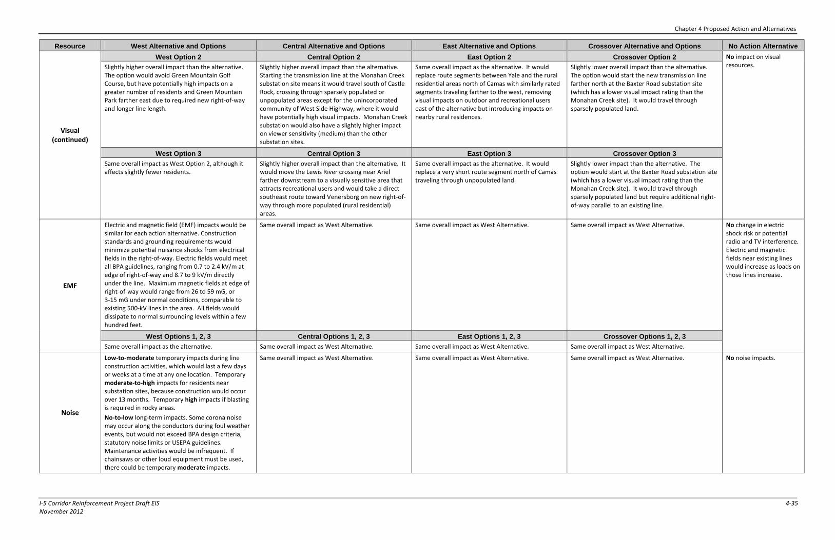
Chapter 4 Proposed Action and Alternatives
I-5 Corridor Reinforcement Project Draft EIS 4-35 November 2012
Resource West Alternative and Options Central Alternative and Options East Alternative and Options Crossover Alternative and Options No Action Alternative
Visual (continued)
West Option 2 Central Option 2 East Option 2 Crossover Option 2 No impact on visual resources. Slightly higher overall impact than the alternative.
The option would avoid Green Mountain Golf Course, but have potentially high impacts on a greater number of residents and Green Mountain Park farther east due to required new right-of-way and longer line length.
Slightly higher overall impact than the alternative. Starting the transmission line at the Monahan Creek substation site means it would travel south of Castle Rock, crossing through sparsely populated or unpopulated areas except for the unincorporated community of West Side Highway, where it would have potentially high visual impacts. Monahan Creek substation would also have a slightly higher impact on viewer sensitivity (medium) than the other substation sites.
Same overall impact as the alternative. It would replace route segments between Yale and the rural residential areas north of Camas with similarly rated segments traveling farther to the west, removing visual impacts on outdoor and recreational users east of the alternative but introducing impacts on nearby rural residences.
Slightly lower overall impact than the alternative. The option would start the new transmission line farther north at the Baxter Road substation site (which has a lower visual impact rating than the Monahan Creek site). It would travel through sparsely populated land.
West Option 3 Central Option 3 East Option 3 Crossover Option 3
Same overall impact as West Option 2, although it affects slightly fewer residents.
Slightly higher overall impact than the alternative. It would move the Lewis River crossing near Ariel farther downstream to a visually sensitive area that attracts recreational users and would take a direct southeast route toward Venersborg on new right-of-way through more populated (rural residential) areas.
Same overall impact as the alternative. It would replace a very short route segment north of Camas traveling through unpopulated land.
Slightly lower impact than the alternative. The option would start at the Baxter Road substation site (which has a lower visual impact rating than the Monahan Creek site). It would travel through sparsely populated land but require additional right-of-way parallel to an existing line.
EMF
Electric and magnetic field (EMF) impacts would be similar for each action alternative. Construction standards and grounding requirements would minimize potential nuisance shocks from electrical fields in the right-of-way. Electric fields would meet all BPA guidelines, ranging from 0.7 to 2.4 kV/m at edge of right-of-way and 8.7 to 9 kV/m directly under the line. Maximum magnetic fields at edge of right-of-way would range from 26 to 59 mG, or 3-15 mG under normal conditions, comparable to existing 500-kV lines in the area. All fields would dissipate to normal surrounding levels within a few hundred feet.
Same overall impact as West Alternative. Same overall impact as West Alternative. Same overall impact as West Alternative. No change in electric shock risk or potential radio and TV interference. Electric and magnetic fields near existing lines would increase as loads on those lines increase.
West Options 1, 2, 3 Central Options 1, 2, 3 East Options 1, 2, 3 Crossover Options 1, 2, 3
Same overall impact as the alternative. Same overall impact as West Alternative. Same overall impact as West Alternative. Same overall impact as West Alternative.
Noise
Low-to-moderate temporary impacts during line construction activities, which would last a few days or weeks at a time at any one location. Temporary moderate-to-high impacts for residents near substation sites, because construction would occur over 13 months. Temporary high impacts if blasting is required in rocky areas.
No-to-low long-term impacts. Some corona noise may occur along the conductors during foul weather events, but would not exceed BPA design criteria, statutory noise limits or USEPA guidelines. Maintenance activities would be infrequent. If chainsaws or other loud equipment must be used, there could be temporary moderate impacts.
Same overall impact as West Alternative. Same overall impact as West Alternative. Same overall impact as West Alternative. No noise impacts.
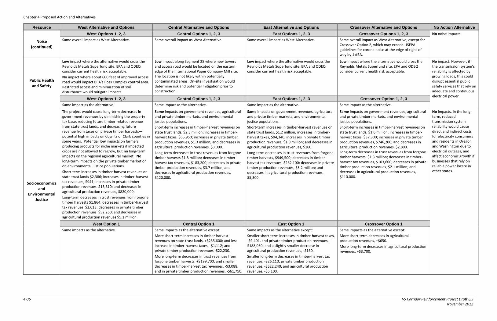
Chapter 4 Proposed Action and Alternatives
4-36 I-5 Corridor Reinforcement Project Draft EIS November 2012
Resource West Alternative and Options Central Alternative and Options East Alternative and Options Crossover Alternative and Options No Action Alternative
Noise (continued)
West Options 1, 2, 3 Central Options 1, 2, 3 East Options 1, 2, 3 Crossover Options 1, 2, 3 No noise impacts
Same overall impact as West Alternative. Same overall impact as West Alternative. Same overall impact as West Alternative. Same overall impact as West Alternative, except for Crossover Option 2, which may exceed USEPA guidelines for corona noise at the edge of right-of-way by 1 dBA.
Public Health and Safety
Low impact where the alternative would cross the Reynolds Metals Superfund site. EPA and ODEQ consider current health risk acceptable.
No impact where about 600 feet of improved access road would impact BPA’s Ross Complex control area. Restricted access and minimization of soil disturbance would mitigate impacts.
Low impact along Segment 28 where new towers and access road would be located on the eastern edge of the International Paper Company Mill site. The location is not likely within potentially contaminated areas. On-site investigation would determine risk and potential mitigation prior to construction.
Low impact where the alternative would cross the Reynolds Metals Superfund site. EPA and ODEQ consider current health risk acceptable.
Low impact where the alternative would cross the Reynolds Metals Superfund site. EPA and ODEQ consider current health risk acceptable.
No impact. However, if the transmission system’s reliability is affected by growing loads, this could disrupt essential public safety services that rely on adequate and continuous electrical power.
West Options 1, 2, 3 Central Options 1, 2, 3 East Options 1, 2, 3 Crossover Option 1, 2, 3
Same impact as the alternative. Same impact as the alternative. Same impact as the alternative. Same impact as the alternative.
Socioeconomics and
Environmental Justice
The project would cause long-term decreases in government revenues by diminishing the property tax base, reducing future timber-related revenue from state trust lands, and decreasing future revenue from taxes on private timber harvests—potential high impacts on Cowlitz or Clark counties in some years. Potential low impacts on farmers producing products for niche markets if impacted crops are not allowed to regrow, but no long-term impacts on the regional agricultural market. No long-term impacts on the private timber market or on environmental justice populations.
Short-term increases in timber-harvest revenues on state trust lands $2,386; increases in timber-harvest tax revenues, $941; increases in private timber production revenues $18,810; and decreases in agricultural production revenues, $820,000;
Long-term decreases in trust revenues from forgone timber harvests $1,864; decreases in timber-harvest tax revenues $2,613; decreases in private timber production revenues $52,260; and decreases in agricultural production revenues $5.1 million.
Same impacts on government revenues, agricultural and private timber markets, and environmental justice populations.
Short-term increases in timber-harvest revenues on state trust lands, $2.3 million; increases in timber-harvest taxes, $65,950; increases in private timber production revenues, $1.3 million; and decreases in agricultural production revenues, $3,000.
Long-term decreases in trust revenues from forgone timber harvests $1.8 million; decreases in timber-harvest tax revenues, $183,200; decreases in private timber production revenues, $3.7 million; and decreases in agricultural production revenues, $120,000.
Same impacts on government revenues, agricultural and private timber markets, and environmental justice populations.
Short-term increases in timber-harvest revenues on state trust lands, $1.2 million; increases in timber-harvest taxes, $94,340; increases in private timber production revenues, $1.9 million; and decreases in agricultural production revenues, $160.
Long-term decreases in trust revenues from forgone timber harvests, $949,500; decreases in timber-harvest tax revenues, $262,100; decreases in private timber production revenues, $5.2 million; and decreases in agricultural production revenues, $5,300.
Same impacts on government revenues, agricultural and private timber markets, and environmental justice populations.
Short-term increases in timber-harvest revenues on state trust lands, $1.6 million; increases in timber-harvest taxes, $37,300; increases in private timber production revenues, $746,200; and decreases in agricultural production revenues, $2,800. Long-term decreases in trust revenues from forgone timber harvests, $1.3 million; decreases in timber-harvest tax revenues, $103,600; decreases in private timber production revenues, $2.1 million; and decreases in agricultural production revenues, $110,000.
No impacts. In the long-term, reduced transmission system reliability would cause direct and indirect costs for electricity consumers and residents in Oregon and Washington due to electrical outages, and affect economic growth if businesses that rely on reliable power locate in other states.
West Option 1 Central Option 1 East Option 1 Crossover Option 1
Same impacts as the alternative. Same impacts as the alternative except:
More short-term increases in timber-harvest revenues on state trust lands, +$255,600; and less increase in timber-harvest taxes, -$1,112; and private timber production revenues -$22,230.
More long-term decreases in trust revenues from forgone timber harvests, +$199,700; and smaller decreases in timber-harvest tax revenues, -$3,088, and in private timber production revenues, -$61,750.
Same impacts as the alternative except:
Smaller short-term increases in timber-harvest taxes, -$9,401, and private timber production revenues, -$188,030; and a slightly smaller decrease in agricultural production revenues, -$160.
Smaller long-term decreases in timber-harvest tax revenues, -$26,110; private timber production revenues, -$522,240; and agricultural production revenues, -$5,100.
Same impacts as the alternative except:
More short-term decreases in agricultural production revenues, +$650.
More long-term decreases in agricultural production revenues, +$3,700.
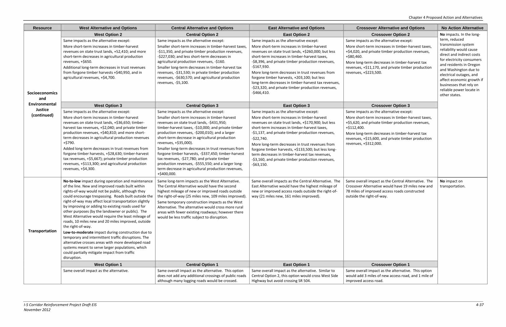
Chapter 4 Proposed Action and Alternatives
I-5 Corridor Reinforcement Project Draft EIS 4-37 November 2012
Resource West Alternative and Options Central Alternative and Options East Alternative and Options Crossover Alternative and Options No Action Alternative
Socioeconomics and
Environmental Justice
(continued)
West Option 2 Central Option 2 East Option 2 Crossover Option 2 No impacts. In the long-term, reduced transmission system reliability would cause direct and indirect costs for electricity consumers and residents in Oregon and Washington due to electrical outages, and affect economic growth if businesses that rely on reliable power locate in other states.
Same impacts as the alternative except:
More short-term increases in timber-harvest revenues on state trust lands, +52,410; and more short-term decreases in agricultural production revenues, +$650.
Additional long-term decreases in trust revenues from forgone timber harvests +$40,950, and in agricultural revenues, +$4,700.
Same impacts as the alternative except:
Smaller short-term increases in timber-harvest taxes, -$11,350, and private timber production revenues, -$227,030; and less short-term decreases in agricultural production revenues, -$160.
Smaller long-term decreases in timber-harvest tax revenues, -$31,530; in private timber production revenues, -$630,570; and agricultural production revenues, -$5,100.
Same impacts as the alternative except:
More short-term increases in timber-harvest revenues on state trust lands, +$260,000; but less short-term increases in timber-harvest taxes, -$8,396, and private timber production revenues, -$167,930.
More long-term decreases in trust revenues from forgone timber harvests, +203,100; but less long-term decreases in timber-harvest tax revenues, -$23,320, and private timber production revenues, -$466,410.
Same impacts as the alternative except:
More short-term increases in timber-harvest taxes, +$4,020, and private timber production revenues, +$80,460.
More long-term decreases in timber-harvest tax revenues, +$11,170, and private timber production revenues, +$223,500.
West Option 3 Central Option 3 East Option 3 Crossover Option 3
Same impacts as the alternative except:
More short-term increases in timber-harvest revenues on state trust lands, +$36,650; timber-harvest tax revenues, +$2,040; and private timber production revenues, +$40,810; and more short-term decreases in agricultural production revenues +$790.
Added long-term decreases in trust revenues from forgone timber harvests, +$28,630; timber-harvest tax revenues, +$5,667); private timber production revenues, +$113,300; and agricultural production revenues, +$4,300.
Same impacts as the alternative except:
Smaller short-term increases in timber-harvest revenues on state trust lands, -$431,950; timber-harvest taxes, -$10,000; and private timber production revenues, -$200,010); and a larger short-term decrease in agricultural production revenues, +$35,000).
Smaller long-term decreases in trust revenues from forgone timber harvests, -$337,450; timber-harvest tax revenues, -$27,780; and private timber production revenues, -$555,550; and a larger long-term decrease in agricultural production revenues, +$400,000.
Same impacts as the alternative except:
More short-term increases in timber-harvest revenues on state trust lands, +$170,900; but less short-term increases in timber-harvest taxes, -$1,137, and private timber production revenues,
-$22,740.
More long-term decreases in trust revenues from forgone timber harvests, +$133,500; but less long-term decreases in timber-harvest tax revenues, -$3,160, and private timber production revenues, -$63,150.
Same impacts as the alternative except:
More short-term increases in timber-harvest taxes, +$5,620, and private timber production revenues, +$112,400.
More long-term decreases in timber-harvest tax revenues, +$15,600, and private timber production revenues, +$312,000.
Transportation
No-to-low impact during operation and maintenance of the line. New and improved roads built within rights-of-way would not be public, although they could encourage trespassing. Roads built outside the right-of-way may affect local transportation slightly by improving or adding to existing roads used for other purposes (by the landowner or public). The West Alternative would require the least mileage of roads, 10 miles new and 20 miles improved, outside the right-of-way.
Low-to-moderate impact during construction due to temporary and intermittent traffic disruptions. The alternative crosses areas with more developed road systems meant to serve larger populations, which could partially mitigate impact from traffic disruption.
Same long-term impacts as the West Alternative. The Central Alternative would have the second highest mileage of new or improved roads outside the right-of-way (25 miles new, 109 miles improved).
Same temporary construction impacts as the West Alternative. The alternative would cross more rural areas with fewer existing roadways; however there would be less traffic subject to disruption.
Same overall impacts as the Central Alternative. The East Alternative would have the highest mileage of new or improved access roads outside the right-of-way (21 miles new, 161 miles improved).
Same overall impact as the Central Alternative. The Crossover Alternative would have 19 miles new and 78 miles of improved access roads constructed outside the right-of-way.
No impact on transportation.
West Option 1 Central Option 1 East Option 1 Crossover Option 1
Same overall impact as the alternative. Same overall impact as the alternative. This option does not add any additional crossings of public roads although many logging roads would be crossed.
Same overall impact as the alternative. Similar to Central Option 2, this option would cross West Side Highway but avoid crossing SR 504.
Same overall impact as the alternative. This option would add 3 miles of new access road, and 1 mile of improved access road.
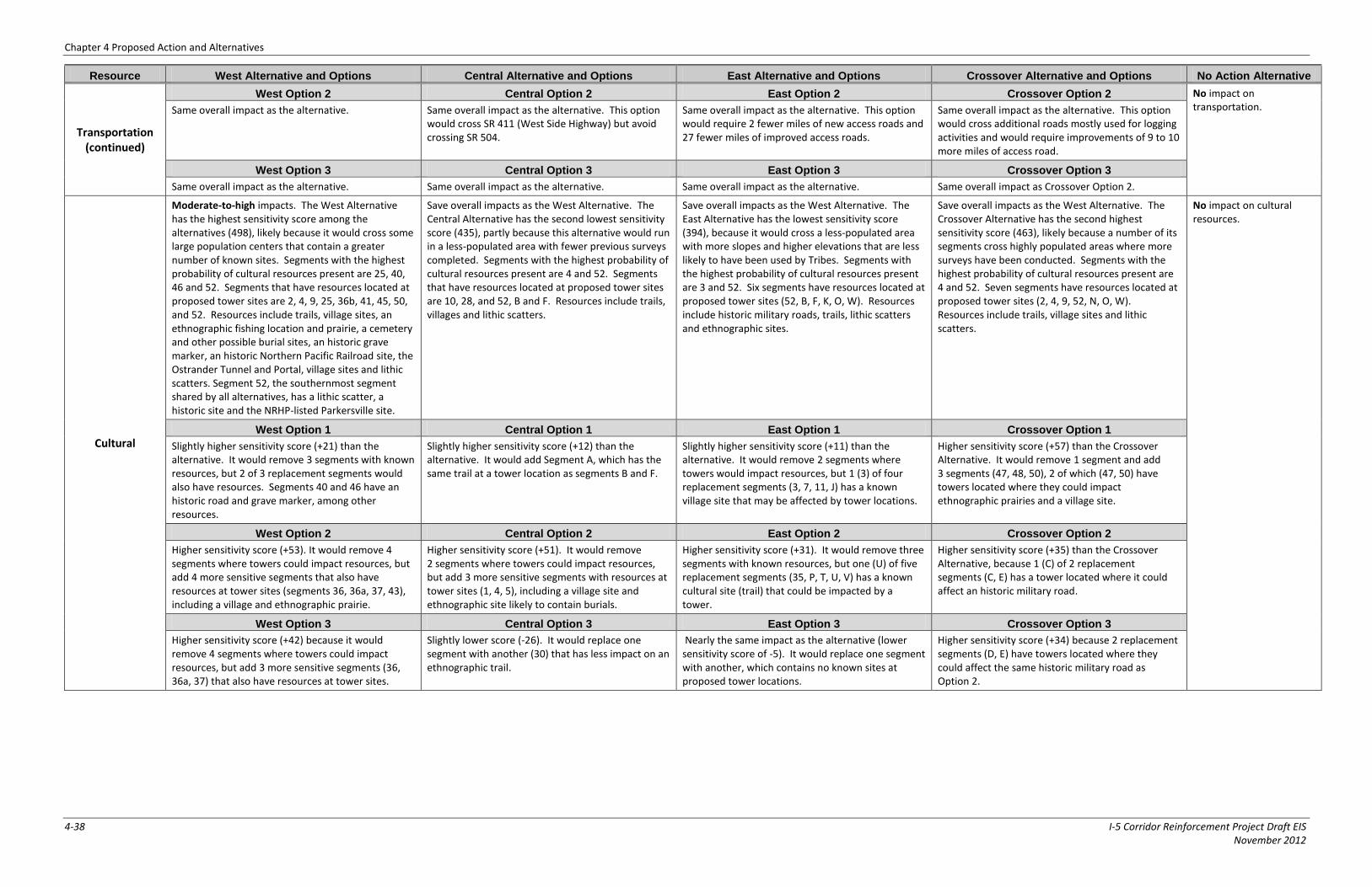
Chapter 4 Proposed Action and Alternatives
4-38 I-5 Corridor Reinforcement Project Draft EIS November 2012
Resource West Alternative and Options Central Alternative and Options East Alternative and Options Crossover Alternative and Options No Action Alternative
Transportation (continued)
West Option 2 Central Option 2 East Option 2 Crossover Option 2 No impact on transportation. Same overall impact as the alternative. Same overall impact as the alternative. This option
would cross SR 411 (West Side Highway) but avoid crossing SR 504.
Same overall impact as the alternative. This option would require 2 fewer miles of new access roads and 27 fewer miles of improved access roads.
Same overall impact as the alternative. This option would cross additional roads mostly used for logging activities and would require improvements of 9 to 10 more miles of access road.
West Option 3 Central Option 3 East Option 3 Crossover Option 3
Same overall impact as the alternative. Same overall impact as the alternative. Same overall impact as the alternative. Same overall impact as Crossover Option 2.
Cultural
Moderate-to-high impacts. The West Alternative has the highest sensitivity score among the alternatives (498), likely because it would cross some large population centers that contain a greater number of known sites. Segments with the highest probability of cultural resources present are 25, 40, 46 and 52. Segments that have resources located at proposed tower sites are 2, 4, 9, 25, 36b, 41, 45, 50, and 52. Resources include trails, village sites, an ethnographic fishing location and prairie, a cemetery and other possible burial sites, an historic grave marker, an historic Northern Pacific Railroad site, the Ostrander Tunnel and Portal, village sites and lithic scatters. Segment 52, the southernmost segment shared by all alternatives, has a lithic scatter, a historic site and the NRHP-listed Parkersville site.
Save overall impacts as the West Alternative. The Central Alternative has the second lowest sensitivity score (435), partly because this alternative would run in a less-populated area with fewer previous surveys completed. Segments with the highest probability of cultural resources present are 4 and 52. Segments that have resources located at proposed tower sites are 10, 28, and 52, B and F. Resources include trails, villages and lithic scatters.
Save overall impacts as the West Alternative. The East Alternative has the lowest sensitivity score (394), because it would cross a less-populated area with more slopes and higher elevations that are less likely to have been used by Tribes. Segments with the highest probability of cultural resources present are 3 and 52. Six segments have resources located at proposed tower sites (52, B, F, K, O, W). Resources include historic military roads, trails, lithic scatters and ethnographic sites.
Save overall impacts as the West Alternative. The Crossover Alternative has the second highest sensitivity score (463), likely because a number of its segments cross highly populated areas where more surveys have been conducted. Segments with the highest probability of cultural resources present are 4 and 52. Seven segments have resources located at proposed tower sites (2, 4, 9, 52, N, O, W). Resources include trails, village sites and lithic scatters.
No impact on cultural resources.
West Option 1 Central Option 1 East Option 1 Crossover Option 1
Slightly higher sensitivity score (+21) than the alternative. It would remove 3 segments with known resources, but 2 of 3 replacement segments would also have resources. Segments 40 and 46 have an historic road and grave marker, among other resources.
Slightly higher sensitivity score (+12) than the alternative. It would add Segment A, which has the same trail at a tower location as segments B and F.
Slightly higher sensitivity score (+11) than the alternative. It would remove 2 segments where towers would impact resources, but 1 (3) of four replacement segments (3, 7, 11, J) has a known village site that may be affected by tower locations.
Higher sensitivity score (+57) than the Crossover Alternative. It would remove 1 segment and add 3 segments (47, 48, 50), 2 of which (47, 50) have towers located where they could impact ethnographic prairies and a village site.
West Option 2 Central Option 2 East Option 2 Crossover Option 2
Higher sensitivity score (+53). It would remove 4 segments where towers could impact resources, but add 4 more sensitive segments that also have resources at tower sites (segments 36, 36a, 37, 43), including a village and ethnographic prairie.
Higher sensitivity score (+51). It would remove 2 segments where towers could impact resources, but add 3 more sensitive segments with resources at tower sites (1, 4, 5), including a village site and ethnographic site likely to contain burials.
Higher sensitivity score (+31). It would remove three segments with known resources, but one (U) of five replacement segments (35, P, T, U, V) has a known cultural site (trail) that could be impacted by a tower.
Higher sensitivity score (+35) than the Crossover Alternative, because 1 (C) of 2 replacement segments (C, E) has a tower located where it could affect an historic military road.
West Option 3 Central Option 3 East Option 3 Crossover Option 3
Higher sensitivity score (+42) because it would remove 4 segments where towers could impact resources, but add 3 more sensitive segments (36, 36a, 37) that also have resources at tower sites.
Slightly lower score (-26). It would replace one segment with another (30) that has less impact on an ethnographic trail.
Nearly the same impact as the alternative (lower sensitivity score of -5). It would replace one segment with another, which contains no known sites at proposed tower locations.
Higher sensitivity score (+34) because 2 replacement segments (D, E) have towers located where they could affect the same historic military road as Option 2.
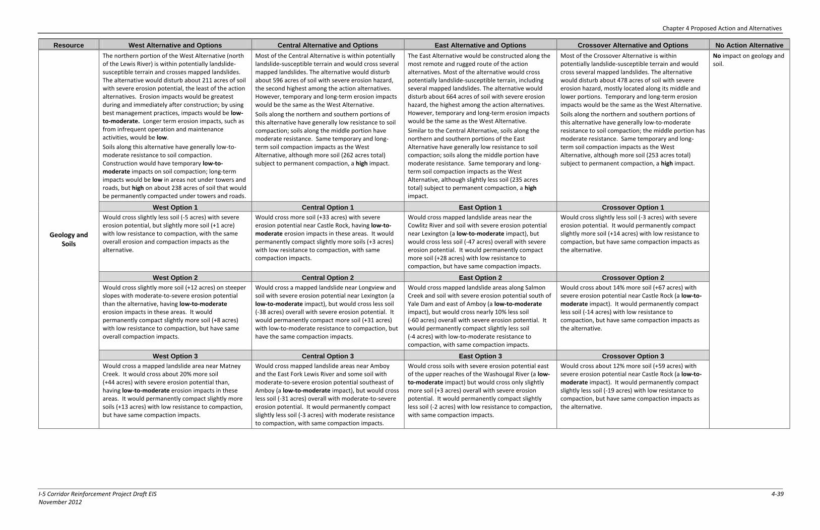
Chapter 4 Proposed Action and Alternatives
I-5 Corridor Reinforcement Project Draft EIS 4-39 November 2012
Resource West Alternative and Options Central Alternative and Options East Alternative and Options Crossover Alternative and Options No Action Alternative
Geology and Soils
The northern portion of the West Alternative (north of the Lewis River) is within potentially landslide-susceptible terrain and crosses mapped landslides. The alternative would disturb about 211 acres of soil with severe erosion potential, the least of the action alternatives. Erosion impacts would be greatest during and immediately after construction; by using best management practices, impacts would be low-to-moderate. Longer term erosion impacts, such as from infrequent operation and maintenance activities, would be low.
Soils along this alternative have generally low-to-moderate resistance to soil compaction. Construction would have temporary low-to-moderate impacts on soil compaction; long-term impacts would be low in areas not under towers and roads, but high on about 238 acres of soil that would be permanently compacted under towers and roads.
Most of the Central Alternative is within potentially landslide-susceptible terrain and would cross several mapped landslides. The alternative would disturb about 596 acres of soil with severe erosion hazard, the second highest among the action alternatives. However, temporary and long-term erosion impacts would be the same as the West Alternative.
Soils along the northern and southern portions of this alternative have generally low resistance to soil compaction; soils along the middle portion have moderate resistance. Same temporary and long-term soil compaction impacts as the West Alternative, although more soil (262 acres total) subject to permanent compaction, a high impact.
The East Alternative would be constructed along the most remote and rugged route of the action alternatives. Most of the alternative would cross potentially landslide-susceptible terrain, including several mapped landslides. The alternative would disturb about 664 acres of soil with severe erosion hazard, the highest among the action alternatives. However, temporary and long-term erosion impacts would be the same as the West Alternative.
Similar to the Central Alternative, soils along the northern and southern portions of the East Alternative have generally low resistance to soil compaction; soils along the middle portion have moderate resistance. Same temporary and long-term soil compaction impacts as the West Alternative, although slightly less soil (235 acres total) subject to permanent compaction, a high impact.
Most of the Crossover Alternative is within potentially landslide-susceptible terrain and would cross several mapped landslides. The alternative would disturb about 478 acres of soil with severe erosion hazard, mostly located along its middle and lower portions. Temporary and long-term erosion impacts would be the same as the West Alternative.
Soils along the northern and southern portions of this alternative have generally low-to-moderate resistance to soil compaction; the middle portion has moderate resistance. Same temporary and long-term soil compaction impacts as the West Alternative, although more soil (253 acres total) subject to permanent compaction, a high impact.
No impact on geology and soil.
West Option 1 Central Option 1 East Option 1 Crossover Option 1
Would cross slightly less soil (-5 acres) with severe erosion potential, but slightly more soil (+1 acre) with low resistance to compaction, with the same overall erosion and compaction impacts as the alternative.
Would cross more soil (+33 acres) with severe erosion potential near Castle Rock, having low-to-moderate erosion impacts in these areas. It would permanently compact slightly more soils (+3 acres) with low resistance to compaction, with same compaction impacts.
Would cross mapped landslide areas near the Cowlitz River and soil with severe erosion potential near Lexington (a low-to-moderate impact), but would cross less soil (-47 acres) overall with severe erosion potential. It would permanently compact more soil (+28 acres) with low resistance to compaction, but have same compaction impacts.
Would cross slightly less soil (-3 acres) with severe erosion potential. It would permanently compact slightly more soil (+14 acres) with low resistance to compaction, but have same compaction impacts as the alternative.
West Option 2 Central Option 2 East Option 2 Crossover Option 2
Would cross slightly more soil (+12 acres) on steeper slopes with moderate-to-severe erosion potential than the alternative, having low-to-moderate erosion impacts in these areas. It would permanently compact slightly more soil (+8 acres) with low resistance to compaction, but have same overall compaction impacts.
Would cross a mapped landslide near Longview and soil with severe erosion potential near Lexington (a low-to-moderate impact), but would cross less soil (-38 acres) overall with severe erosion potential. It would permanently compact more soil (+31 acres) with low-to-moderate resistance to compaction, but have the same compaction impacts.
Would cross mapped landslide areas along Salmon Creek and soil with severe erosion potential south of Yale Dam and east of Amboy (a low-to-moderate impact), but would cross nearly 10% less soil (-60 acres) overall with severe erosion potential. It would permanently compact slightly less soil (-4 acres) with low-to-moderate resistance to compaction, with same compaction impacts.
Would cross about 14% more soil (+67 acres) with severe erosion potential near Castle Rock (a low-to-moderate impact). It would permanently compact less soil (-14 acres) with low resistance to compaction, but have same compaction impacts as the alternative.
West Option 3 Central Option 3 East Option 3 Crossover Option 3
Would cross a mapped landslide area near Matney Creek. It would cross about 20% more soil (+44 acres) with severe erosion potential than, having low-to-moderate erosion impacts in these areas. It would permanently compact slightly more soils (+13 acres) with low resistance to compaction, but have same compaction impacts.
Would cross mapped landslide areas near Amboy and the East Fork Lewis River and some soil with moderate-to-severe erosion potential southeast of Amboy (a low-to-moderate impact), but would cross less soil (-31 acres) overall with moderate-to-severe erosion potential. It would permanently compact slightly less soil (-3 acres) with moderate resistance to compaction, with same compaction impacts.
Would cross soils with severe erosion potential east of the upper reaches of the Washougal River (a low-to-moderate impact) but would cross only slightly more soil (+3 acres) overall with severe erosion potential. It would permanently compact slightly less soil (-2 acres) with low resistance to compaction, with same compaction impacts.
Would cross about 12% more soil (+59 acres) with severe erosion potential near Castle Rock (a low-to-moderate impact). It would permanently compact slightly less soil (-19 acres) with low resistance to compaction, but have same compaction impacts as the alternative.
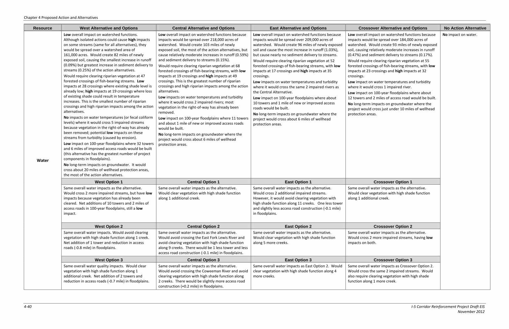
Chapter 4 Proposed Action and Alternatives
4-40 I-5 Corridor Reinforcement Project Draft EIS November 2012
Resource West Alternative and Options Central Alternative and Options East Alternative and Options Crossover Alternative and Options No Action Alternative
Water
Low overall impact on watershed functions. Although isolated actions could cause high impacts on some streams (same for all alternatives), they would be spread over a watershed area of 161,000 acres. Would create 82 miles of newly exposed soil, causing the smallest increase in runoff (0.09%) but greatest increase in sediment delivery to streams (0.25%) of the action alternatives.
Would require clearing riparian vegetation at 47 forested crossings of fish-bearing streams. Low impacts at 28 crossings where existing shade level is already low; high impacts at 19 crossings where loss of existing shade could result in temperature increases. This is the smallest number of riparian crossings and high riparian impacts among the action alternatives.
No impacts on water temperatures (or fecal coliform levels) where it would cross 5 impaired streams because vegetation in the right-of-way has already been removed; potential low impacts on these streams from turbidity (caused by erosion).
Low impact on 100-year floodplains where 32 towers and 6 miles of improved access roads would be built (this alternative has the greatest number of project components in floodplains).
No long-term impacts on groundwater. It would cross about 20 miles of wellhead protection areas, the most of the action alternatives.
Low overall impact on watershed functions because impacts would be spread over 218,000 acres of watershed. Would create 103 miles of newly exposed soil, the most of the action alternatives, but cause relatively moderate increases in runoff (0.59%) and sediment delivery to streams (0.15%).
Would require clearing riparian vegetation at 68 forested crossings of fish-bearing streams, with low impacts at 19 crossings and high impacts at 49 crossings. This is the greatest number of riparian crossings and high riparian impacts among the action alternatives.
Low impacts on water temperatures and turbidity where it would cross 2 impaired rivers; most vegetation in the right-of-way has already been removed.
Low impact on 100-year floodplains where 11 towers and about 1 mile of new or improved access roads would be built.
No long-term impacts on groundwater where the project would cross about 6 miles of wellhead protection areas.
Low overall impact on watershed functions because impacts would be spread over 209,000 acres of watershed. Would create 96 miles of newly exposed soil and cause the most increase in runoff (1.03%), but cause nearly no sediment delivery to streams.
Would require clearing riparian vegetation at 52 forested crossings of fish-bearing streams, with low impacts at 17 crossings and high impacts at 35 crossings.
Low impacts on water temperatures and turbidity where it would cross the same 2 impaired rivers as the Central Alternative.
Low impact on 100-year floodplains where about 10 towers and 1 mile of new or improved access roads would be built.
No long-term impacts on groundwater where the project would cross about 6 miles of wellhead protection areas.
Low overall impact on watershed functions because impacts would be spread over 184,000 acres of watershed. Would create 93 miles of newly exposed soil, causing relatively moderate increases in runoff (0.47%) and sediment delivery to streams (0.17%).
Would require clearing riparian vegetation at 55 forested crossings of fish-bearing streams, with low impacts at 23 crossings and high impacts at 32 crossings.
Low impact on water temperatures and turbidity where it would cross 1 impaired river.
Low impact on 100-year floodplains where about 12 towers and 2 miles of access road would be built.
No long-term impacts on groundwater where the project would cross just under 10 miles of wellhead protection areas.
No impact on water.
West Option 1 Central Option 1 East Option 1 Crossover Option 1
Same overall water impacts as the alternative. Would cross 2 more impaired streams, but have low impacts because vegetation has already been cleared. Net additions of 10 towers and 2 miles of access roads in 100-year floodplains, still a low impact.
Same overall water impacts as the alternative. Would clear vegetation with high shade function along 1 additional creek.
Same overall water impacts as the alternative. Would cross 2 additional impaired streams. However, it would avoid clearing vegetation with high shade function along 11 creeks. One less tower and slightly less access road construction (-0.1 mile) in floodplains.
Same overall water impacts as the alternative. Would clear vegetation with high shade function along 1 additional creek.
West Option 2 Central Option 2 East Option 2 Crossover Option 2
Same overall water impacts. Would avoid clearing vegetation with high shade function along 1 creek. Net addition of 1 tower and reduction in access roads (-0.8 mile) in floodplains.
Same overall water impacts as the alternative. Would avoid crossing the East Fork Lewis River and avoid clearing vegetation with high shade function along 9 creeks. There would be 1 less tower and less access road construction (-0.1 mile) in floodplains.
Same overall water impacts as the alternative. Would clear vegetation with high shade function along 5 more creeks.
Same overall water impacts as the alternative. Would cross 2 more impaired streams, having low impacts on both.
West Option 3 Central Option 3 East Option 3 Crossover Option 3
Same overall water quality impacts. Would clear vegetation with high shade function along 1 additional creek. Net addition of 2 towers and reduction in access roads (-0.7 mile) in floodplains.
Same overall water impacts as the alternative. Would avoid crossing the Coweeman River and avoid clearing vegetation with high shade function along 2 creeks. There would be slightly more access road construction (+0.2 mile) in floodplains.
Same overall water impacts as East Option 2. Would clear vegetation with high shade function along 4 more creeks.
Same overall water impacts as Crossover Option 2. Would cross the same 2 impaired streams. Would also require clearing vegetation with high shade function along 1 more creek.
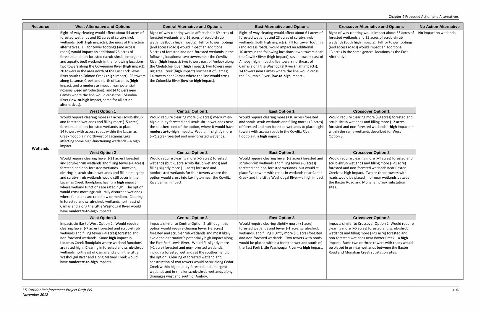
Chapter 4 Proposed Action and Alternatives
I-5 Corridor Reinforcement Project Draft EIS 4-41 November 2012
Resource West Alternative and Options Central Alternative and Options East Alternative and Options Crossover Alternative and Options No Action Alternative
Wetlands
Right-of-way clearing would affect about 54 acres of forested wetlands and 62 acres of scrub-shrub wetlands (both high impacts), the most of the action alternatives. Fill for tower footings (and access roads) would impact an additional 25 acres of forested and non-forested (scrub-shrub, emergent and aquatic bed) wetlands in the following locations: two towers along the Coweeman River (high impact); 20 towers in the area north of the East Fork Lewis River south to Salmon Creek (high impact); 26 towers along Lacamas Creek and north of Lacamas (high impact, and a moderate impact from potential noxious weed introduction); and14 towers near Camas where the line would cross the Columbia River (low-to-high impact, same for all action alternatives).
Right-of-way clearing would affect about 69 acres of forested wetlands and 16 acres of scrub-shrub wetlands (both high impacts). Fill for tower footings (and access roads) would impact an additional 8 acres of forested and non-forested wetlands in the following locations: two towers near the Cowlitz River (high impact); two towers east of Amboy along the Chelatchie River (high impact); two towers near Big Tree Creek (high impact) northeast of Camas; 14 towers near Camas where the line would cross the Columbia River (low-to-high impact).
Right-of-way clearing would affect about 61 acres of forested wetlands and 23 acres of scrub-shrub wetlands (both high impacts). Fill for tower footings (and access roads) would impact an additional 10 acres in the following locations: two towers near the Cowlitz River (high impact); seven towers east of Amboy (high impact); five towers northeast of Camas along the Washougal River (high impacts); 14 towers near Camas where the line would cross the Columbia River (low-to-high impact).
Right-of-way clearing would impact about 53 acres of forested wetlands and 35 acres of scrub-shrub wetlands (both high impacts). Fill for tower footings (and access roads) would impact an additional 13 acres in the same general locations as the East Alternative.
No impact on wetlands.
West Option 1 Central Option 1 East Option 1 Crossover Option 1
Would require clearing more (+7 acres) scrub-shrub and forested wetlands and filling more (+5 acres) forested and non-forested wetlands to place 14 towers with access roads within the Lacamas Creek floodplain northwest of Lacamas Lake, affecting some high-functioning wetlands—a high impact.
Would require clearing more (+2 acres) medium-to-high quality forested and scrub-shrub wetlands near the southern end of the option, where it would have moderate-to-high impacts. Would fill slightly more (+<1 acre) forested and non-forested wetlands.
Would require clearing more (+10 acres) forested and shrub-scrub wetlands and filling more (+3 acres) of forested and non-forested wetlands to place eight towers with access roads in the Cowlitz River floodplain, a high impact.
Would require clearing more (+9 acres) forested and scrub-shrub wetlands and filling more (+2 acres) forested and non-forested wetlands—high impacts—within the same wetlands described for West Option 3.
West Option 2 Central Option 2 East Option 2 Crossover Option 2
Would require clearing fewer (-11 acres) forested and scrub-shrub wetlands and filling fewer (-4 acres) forested and non-forested wetlands. However, clearing in scrub-shrub wetlands and fill in emergent and scrub-shrub wetlands would still occur in the Lacamas Creek floodplain, having a high impact where wetland functions are rated high. The option would cross more agriculturally disturbed wetlands where functions are rated low or medium. Clearing in forested and scrub-shrub wetlands northeast of Camas and along the Little Washougal River would have moderate-to-high impacts.
Would require clearing more (+5 acres) forested wetlands (but -1 acre scrub-shrub wetlands) and filling slightly more (+1 acre) forested and nonforested wetlands for four towers where the option would cross into Lexington near the Cowlitz River, a high impact.
Would require clearing fewer (-3 acres) forested and scrub-shrub wetlands and filling fewer (-3 acres) forested and non-forested wetlands, but would still place five towers with roads in wetlands near Cedar Creek and the Little Washougal River—a high impact.
Would require clearing more (+4 acres) forested and scrub-shrub wetlands and filling more (+<1 acre) forested and non-forested wetlands near Baxter Creek—a high impact. Two or three towers with roads would be placed in or near wetlands between the Baxter Road and Monahan Creek substation sites.
West Option 3 Central Option 3 East Option 3 Crossover Option 3
Impacts similar to West Option 2. Would require clearing fewer (-7 acres) forested and scrub-shrub wetlands and filling fewer (-4 acres) forested and non-forested wetlands. Same high impact in Lacamas Creek floodplain where wetland functions are rated high. Clearing in forested and scrub-shrub wetlands northeast of Camas and along the Little Washougal River and along Matney Creek would have moderate-to-high impacts.
Impacts similar to Central Option 2, although this option would require clearing fewer (-3 acres) forested and scrub-shrub wetlands and most likely avoid the alternative’s potentially high impact along the East Fork Lewis River. Would fill slightly more (+1 acre) forested and non-forested wetlands, including forested wetlands at the southern end of the option. Clearing of forested wetland and construction of two towers would occur along Cedar Creek within high quality forested and emergent wetlands and in smaller scrub-shrub wetlands along drainages west and south of Amboy.
Would require clearing slightly more (+1 acre) forested wetlands and fewer (-1 acre) scrub-shrub wetlands, and filling slightly more (+1 acre) forested and non-forested wetlands. Two towers with roads would be placed within a forested wetland south of the East Fork Little Washougal River—a high impact.
Impacts similar to Crossover Option 2. Would require clearing more (+5 acres) forested and scrub-shrub wetlands and filling more (+<1 acre) forested and non-forested wetlands near Baxter Creek—a high impact. Same two or three towers with roads would be placed in or near wetlands between the Baxter Road and Monahan Creek substation sites.
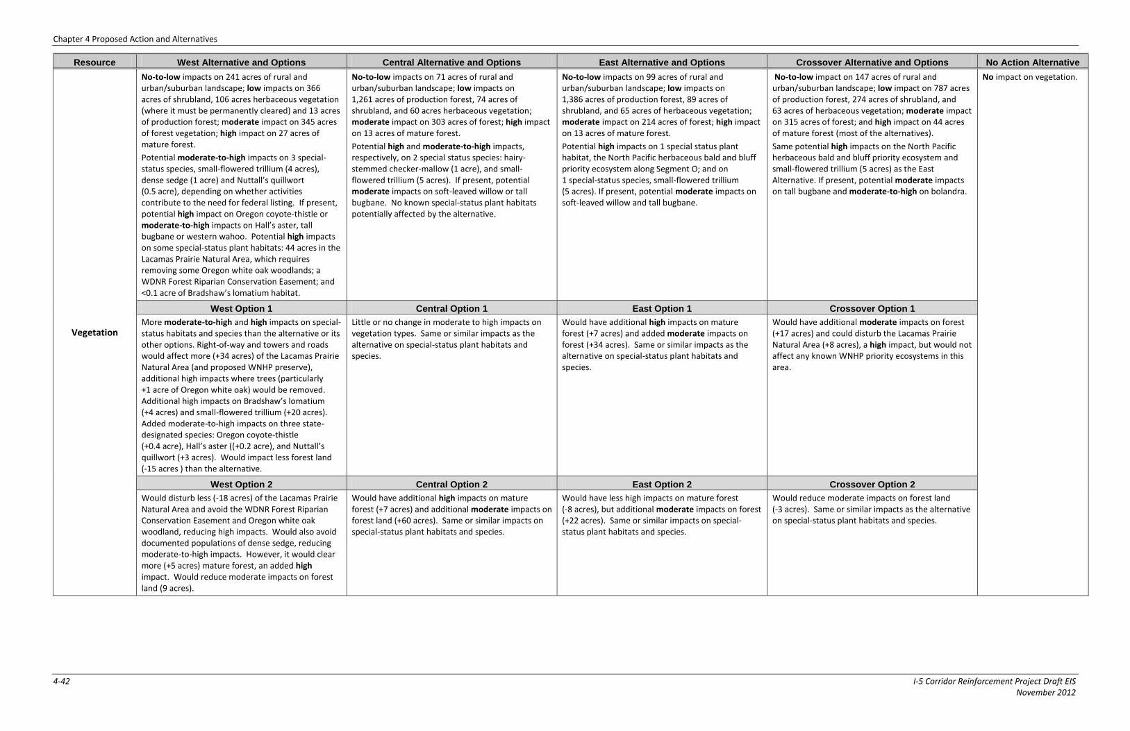
Chapter 4 Proposed Action and Alternatives
4-42 I-5 Corridor Reinforcement Project Draft EIS November 2012
Resource West Alternative and Options Central Alternative and Options East Alternative and Options Crossover Alternative and Options No Action Alternative
Vegetation
No-to-low impacts on 241 acres of rural and urban/suburban landscape; low impacts on 366 acres of shrubland, 106 acres herbaceous vegetation (where it must be permanently cleared) and 13 acres of production forest; moderate impact on 345 acres of forest vegetation; high impact on 27 acres of mature forest.
Potential moderate-to-high impacts on 3 special-status species, small-flowered trillium (4 acres), dense sedge (1 acre) and Nuttall’s quillwort (0.5 acre), depending on whether activities contribute to the need for federal listing. If present, potential high impact on Oregon coyote-thistle or moderate-to-high impacts on Hall’s aster, tall bugbane or western wahoo. Potential high impacts on some special-status plant habitats: 44 acres in the Lacamas Prairie Natural Area, which requires removing some Oregon white oak woodlands; a WDNR Forest Riparian Conservation Easement; and <0.1 acre of Bradshaw’s lomatium habitat.
No-to-low impacts on 71 acres of rural and urban/suburban landscape; low impacts on 1,261 acres of production forest, 74 acres of shrubland, and 60 acres herbaceous vegetation; moderate impact on 303 acres of forest; high impact on 13 acres of mature forest.
Potential high and moderate-to-high impacts, respectively, on 2 special status species: hairy-stemmed checker-mallow (1 acre), and small-flowered trillium (5 acres). If present, potential moderate impacts on soft-leaved willow or tall bugbane. No known special-status plant habitats potentially affected by the alternative.
No-to-low impacts on 99 acres of rural and urban/suburban landscape; low impacts on 1,386 acres of production forest, 89 acres of shrubland, and 65 acres of herbaceous vegetation; moderate impact on 214 acres of forest; high impact on 13 acres of mature forest.
Potential high impacts on 1 special status plant habitat, the North Pacific herbaceous bald and bluff priority ecosystem along Segment O; and on 1 special-status species, small-flowered trillium (5 acres). If present, potential moderate impacts on soft-leaved willow and tall bugbane.
No-to-low impact on 147 acres of rural and urban/suburban landscape; low impact on 787 acres of production forest, 274 acres of shrubland, and 63 acres of herbaceous vegetation; moderate impact on 315 acres of forest; and high impact on 44 acres of mature forest (most of the alternatives).
Same potential high impacts on the North Pacific herbaceous bald and bluff priority ecosystem and small-flowered trillium (5 acres) as the East Alternative. If present, potential moderate impacts on tall bugbane and moderate-to-high on bolandra.
No impact on vegetation.
West Option 1 Central Option 1 East Option 1 Crossover Option 1
More moderate-to-high and high impacts on special-status habitats and species than the alternative or its other options. Right-of-way and towers and roads would affect more (+34 acres) of the Lacamas Prairie Natural Area (and proposed WNHP preserve), additional high impacts where trees (particularly +1 acre of Oregon white oak) would be removed. Additional high impacts on Bradshaw’s lomatium (+4 acres) and small-flowered trillium (+20 acres). Added moderate-to-high impacts on three state-designated species: Oregon coyote-thistle (+0.4 acre), Hall’s aster ((+0.2 acre), and Nuttall’s quillwort (+3 acres). Would impact less forest land (-15 acres ) than the alternative.
Little or no change in moderate to high impacts on vegetation types. Same or similar impacts as the alternative on special-status plant habitats and species.
Would have additional high impacts on mature forest (+7 acres) and added moderate impacts on forest (+34 acres). Same or similar impacts as the alternative on special-status plant habitats and species.
Would have additional moderate impacts on forest (+17 acres) and could disturb the Lacamas Prairie Natural Area (+8 acres), a high impact, but would not affect any known WNHP priority ecosystems in this area.
West Option 2 Central Option 2 East Option 2 Crossover Option 2
Would disturb less (-18 acres) of the Lacamas Prairie Natural Area and avoid the WDNR Forest Riparian Conservation Easement and Oregon white oak woodland, reducing high impacts. Would also avoid documented populations of dense sedge, reducing moderate-to-high impacts. However, it would clear more (+5 acres) mature forest, an added high impact. Would reduce moderate impacts on forest land (9 acres).
Would have additional high impacts on mature forest (+7 acres) and additional moderate impacts on forest land (+60 acres). Same or similar impacts on special-status plant habitats and species.
Would have less high impacts on mature forest (-8 acres), but additional moderate impacts on forest (+22 acres). Same or similar impacts on special-status plant habitats and species.
Would reduce moderate impacts on forest land (-3 acres). Same or similar impacts as the alternative on special-status plant habitats and species.
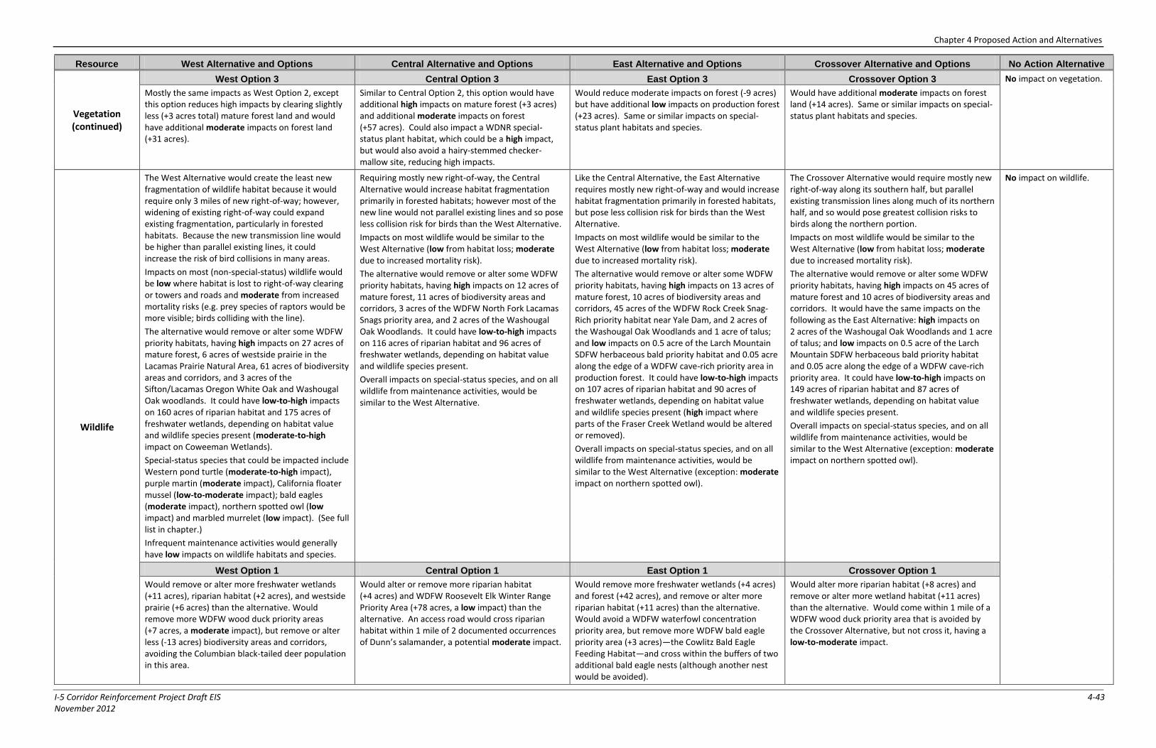
Chapter 4 Proposed Action and Alternatives
I-5 Corridor Reinforcement Project Draft EIS 4-43 November 2012
Resource West Alternative and Options Central Alternative and Options East Alternative and Options Crossover Alternative and Options No Action Alternative
Vegetation (continued)
West Option 3 Central Option 3 East Option 3 Crossover Option 3 No impact on vegetation.
Mostly the same impacts as West Option 2, except this option reduces high impacts by clearing slightly less (+3 acres total) mature forest land and would have additional moderate impacts on forest land (+31 acres).
Similar to Central Option 2, this option would have additional high impacts on mature forest (+3 acres) and additional moderate impacts on forest (+57 acres). Could also impact a WDNR special-status plant habitat, which could be a high impact, but would also avoid a hairy-stemmed checker-mallow site, reducing high impacts.
Would reduce moderate impacts on forest (-9 acres) but have additional low impacts on production forest (+23 acres). Same or similar impacts on special-status plant habitats and species.
Would have additional moderate impacts on forest land (+14 acres). Same or similar impacts on special-status plant habitats and species.
Wildlife
The West Alternative would create the least new fragmentation of wildlife habitat because it would require only 3 miles of new right-of-way; however, widening of existing right-of-way could expand existing fragmentation, particularly in forested habitats. Because the new transmission line would be higher than parallel existing lines, it could increase the risk of bird collisions in many areas.
Impacts on most (non-special-status) wildlife would be low where habitat is lost to right-of-way clearing or towers and roads and moderate from increased mortality risks (e.g. prey species of raptors would be more visible; birds colliding with the line).
The alternative would remove or alter some WDFW priority habitats, having high impacts on 27 acres of mature forest, 6 acres of westside prairie in the Lacamas Prairie Natural Area, 61 acres of biodiversity areas and corridors, and 3 acres of the Sifton/Lacamas Oregon White Oak and Washougal Oak woodlands. It could have low-to-high impacts on 160 acres of riparian habitat and 175 acres of freshwater wetlands, depending on habitat value and wildlife species present (moderate-to-high impact on Coweeman Wetlands).
Special-status species that could be impacted include Western pond turtle (moderate-to-high impact), purple martin (moderate impact), California floater mussel (low-to-moderate impact); bald eagles (moderate impact), northern spotted owl (low impact) and marbled murrelet (low impact). (See full list in chapter.)
Infrequent maintenance activities would generally have low impacts on wildlife habitats and species.
Requiring mostly new right-of-way, the Central Alternative would increase habitat fragmentation primarily in forested habitats; however most of the new line would not parallel existing lines and so pose less collision risk for birds than the West Alternative.
Impacts on most wildlife would be similar to the West Alternative (low from habitat loss; moderate due to increased mortality risk).
The alternative would remove or alter some WDFW priority habitats, having high impacts on 12 acres of mature forest, 11 acres of biodiversity areas and corridors, 3 acres of the WDFW North Fork Lacamas Snags priority area, and 2 acres of the Washougal Oak Woodlands. It could have low-to-high impacts on 116 acres of riparian habitat and 96 acres of freshwater wetlands, depending on habitat value and wildlife species present.
Overall impacts on special-status species, and on all wildlife from maintenance activities, would be similar to the West Alternative.
Like the Central Alternative, the East Alternative requires mostly new right-of-way and would increase habitat fragmentation primarily in forested habitats, but pose less collision risk for birds than the West Alternative.
Impacts on most wildlife would be similar to the West Alternative (low from habitat loss; moderate due to increased mortality risk).
The alternative would remove or alter some WDFW priority habitats, having high impacts on 13 acres of mature forest, 10 acres of biodiversity areas and corridors, 45 acres of the WDFW Rock Creek Snag-Rich priority habitat near Yale Dam, and 2 acres of the Washougal Oak Woodlands and 1 acre of talus; and low impacts on 0.5 acre of the Larch Mountain SDFW herbaceous bald priority habitat and 0.05 acre along the edge of a WDFW cave-rich priority area in production forest. It could have low-to-high impacts on 107 acres of riparian habitat and 90 acres of freshwater wetlands, depending on habitat value and wildlife species present (high impact where parts of the Fraser Creek Wetland would be altered or removed).
Overall impacts on special-status species, and on all wildlife from maintenance activities, would be similar to the West Alternative (exception: moderate impact on northern spotted owl).
The Crossover Alternative would require mostly new right-of-way along its southern half, but parallel existing transmission lines along much of its northern half, and so would pose greatest collision risks to birds along the northern portion.
Impacts on most wildlife would be similar to the West Alternative (low from habitat loss; moderate due to increased mortality risk).
The alternative would remove or alter some WDFW priority habitats, having high impacts on 45 acres of mature forest and 10 acres of biodiversity areas and corridors. It would have the same impacts on the following as the East Alternative: high impacts on 2 acres of the Washougal Oak Woodlands and 1 acre of talus; and low impacts on 0.5 acre of the Larch Mountain SDFW herbaceous bald priority habitat and 0.05 acre along the edge of a WDFW cave-rich priority area. It could have low-to-high impacts on 149 acres of riparian habitat and 87 acres of freshwater wetlands, depending on habitat value and wildlife species present.
Overall impacts on special-status species, and on all wildlife from maintenance activities, would be similar to the West Alternative (exception: moderate impact on northern spotted owl).
No impact on wildlife.
West Option 1 Central Option 1 East Option 1 Crossover Option 1
Would remove or alter more freshwater wetlands (+11 acres), riparian habitat (+2 acres), and westside prairie (+6 acres) than the alternative. Would remove more WDFW wood duck priority areas (+7 acres, a moderate impact), but remove or alter less (-13 acres) biodiversity areas and corridors, avoiding the Columbian black-tailed deer population in this area.
Would alter or remove more riparian habitat (+4 acres) and WDFW Roosevelt Elk Winter Range Priority Area (+78 acres, a low impact) than the alternative. An access road would cross riparian habitat within 1 mile of 2 documented occurrences of Dunn’s salamander, a potential moderate impact.
Would remove more freshwater wetlands (+4 acres) and forest (+42 acres), and remove or alter more riparian habitat (+11 acres) than the alternative. Would avoid a WDFW waterfowl concentration priority area, but remove more WDFW bald eagle priority area (+3 acres)—the Cowlitz Bald Eagle Feeding Habitat—and cross within the buffers of two additional bald eagle nests (although another nest would be avoided).
Would alter more riparian habitat (+8 acres) and remove or alter more wetland habitat (+11 acres) than the alternative. Would come within 1 mile of a WDFW wood duck priority area that is avoided by the Crossover Alternative, but not cross it, having a low-to-moderate impact.
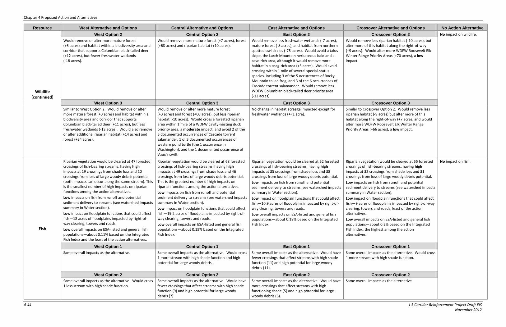
Chapter 4 Proposed Action and Alternatives
4-44 I-5 Corridor Reinforcement Project Draft EIS November 2012
Resource West Alternative and Options Central Alternative and Options East Alternative and Options Crossover Alternative and Options No Action Alternative
Wildlife (continued)
West Option 2 Central Option 2 East Option 2 Crossover Option 2 No impact on wildlife.
Would remove or alter more mature forest (+5 acres) and habitat within a biodiversity area and corridor that supports Columbian black-tailed deer (+12 acres), but fewer freshwater wetlands (-18 acres).
Would remove more mature forest (+7 acres), forest (+68 acres) and riparian habitat (+10 acres).
Would remove less freshwater wetlands (-7 acres), mature forest (-8 acres), and habitat from northern spotted owl circles (-75 acres). Would avoid a talus slope, the Larch Mountain herbaceous bald and a cave-rich area, although it would remove more habitat in a snag-rich area (+3 acres). Would avoid crossing within 1 mile of several special-status species, including 3 of the 5 occurrences of Rocky Mountain tailed frog, and 3 of the 6 occurrences of Cascade torrent salamander. Would remove less WDFW Columbian black-tailed deer priority area (-12 acres).
Would remove less riparian habitat (-10 acres), but alter more of this habitat along the right-of-way (+9 acres). Would alter more WDFW Roosevelt Elk Winter Range Priority Areas (+70 acres), a low impact.
West Option 3 Central Option 3 East Option 3 Crossover Option 3
Similar to West Option 2. Would remove or alter more mature forest (+3 acres) and habitat within a biodiversity area and corridor that supports Columbian black-tailed deer (+11 acres), but less freshwater wetlands (-13 acres). Would also remove or alter additional riparian habitat (+14 acres) and forest (+34 acres).
Would remove or alter more mature forest (+3 acres) and forest (+60 acres), but less riparian habitat (-10 acres). Would cross a forested riparian area within 1 mile of a WDFW cavity-nesting duck priority area, a moderate impact, and avoid 2 of the 5 documented occurrences of Cascade torrent salamander, 1 of 3 documented occurrences of western pond turtle (the 1 occurrence in Washington), and the 1 documented occurrence of Vaux’s swift.
No change in habitat acreage impacted except for freshwater wetlands (+<1 acre).
Similar to Crossover Option 2. Would remove less riparian habitat (-9 acres) but alter more of this habitat along the right-of-way (+7 acres, and would alter more WDFW Roosevelt Elk Winter Range Priority Areas (+66 acres), a low impact.
Fish
Riparian vegetation would be cleared at 47 forested crossings of fish-bearing streams, having high impacts at 19 crossings from shade loss and 10 crossings from loss of large woody debris potential (both impacts can occur along the same stream). This is the smallest number of high impacts on riparian functions among the action alternatives.
Low impacts on fish from runoff and potential sediment delivery to streams (see watershed impacts summary in Water section).
Low impact on floodplain functions that could affect fish—18 acres of floodplains impacted by right-of-way clearing, towers and roads.
Low overall impacts on ESA-listed and general fish populations—about 0.11% based on the Integrated Fish Index and the least of the action alternatives.
Riparian vegetation would be cleared at 68 forested crossings of fish-bearing streams, having high impacts at 49 crossings from shade loss and 46 crossings from loss of large woody debris potential. This is the greatest number of high impacts on riparian functions among the action alternatives.
Low impacts on fish from runoff and potential sediment delivery to streams (see watershed impacts summary in Water section).
Low impact on floodplain functions that could affect fish—19.2 acres of floodplains impacted by right-of-way clearing, towers and roads.
Low overall impacts on ESA-listed and general fish populations—about 0.15% based on the Integrated Fish Index.
Riparian vegetation would be cleared at 52 forested crossings of fish-bearing streams, having high impacts at 35 crossings from shade loss and 38 crossings from loss of large woody debris potential.
Low impacts on fish from runoff and potential sediment delivery to streams (see watershed impacts summary in Water section).
Low impact on floodplain functions that could affect fish—10.9 acres of floodplains impacted by right-of-way clearing, towers and roads.
Low overall impacts on ESA-listed and general fish populations—about 0.19% based on the Integrated Fish Index.
Riparian vegetation would be cleared at 55 forested crossings of fish-bearing streams, having high impacts at 32 crossings from shade loss and 31 crossings from loss of large woody debris potential.
Low impacts on fish from runoff and potential sediment delivery to streams (see watershed impacts summary in Water section).
Low impact on floodplain functions that could affect fish—9 acres of floodplains impacted by right-of-way clearing, towers and roads, least of the action alternatives.
Low overall impacts on ESA-listed and general fish populations—about 0.2% based on the Integrated Fish Index, the highest among the action alternatives.
No impact on fish.
West Option 1 Central Option 1 East Option 1 Crossover Option 1
Same overall impacts as the alternative. Same overall impacts as the alternative. Would cross 1 more stream with high shade function and high potential for large woody debris.
Same overall impacts as the alternative. Would have fewer crossings that affect streams with high shade function (11) and high potential for large woody debris (11).
Same overall impacts as the alternative. Would cross 1 more stream with high shade function.
West Option 2 Central Option 2 East Option 2 Crossover Option 2
Same overall impacts as the alternative. Would cross 1 less stream with high shade function.
Same overall impacts as the alternative. Would have fewer crossings that affect streams with high shade function (9) and high potential for large woody debris (7).
Same overall impacts as the alternative. Would have more crossings that affect streams with high-functioning shade (5) and high potential for large woody debris (6).
Same overall impacts as the alternative.

Chapter 4 Proposed Action and Alternatives
I-5 Corridor Reinforcement Project Draft EIS 4-45 November 2012
Resource West Alternative and Options Central Alternative and Options East Alternative and Options Crossover Alternative and Options No Action Alternative
Fish (continued)
West Option 3 Central Option 3 East Option 3 Crossover Option 3 No impact on fish.
Same overall impacts as the alternative. Would have more crossings that affect streams with high shade function (1) and high potential for large woody debris (2).
Same overall impacts as the alternative. Would have fewer crossings that affect streams with high shade function (2) and high potential for large woody debris (3).
Same overall impacts as the alternative. Would have more crossings that affect streams with high shade function (4) and high potential for large woody debris (4).
Same overall impacts as the alternative. Would have more crossings that affect streams with high shade function (1) and high potential for large woody debris (1).
Climate
No impact on climate. No impact on climate. No impact on climate. No impact on climate. No impact on climate.
West Options 1, 2, 3 Central Options 1, 2, 3 East Options 1, 2, 3 Crossover Options 1, 2, 3
Same impact as the West Alternative. Same impact as the West Alternative. Same impact as the West Alternative. Same impact as the West Alternative.
Air Quality
Low impact during construction and maintenance activities from exhaust emissions and airborne dust; no impacts from corona during operation because pollutants emitted would be very small, temporary, and not detectable above background levels.
Same impact as the West Alternative. Same impact as the West Alternative. Same impact as the West Alternative. No-to-low impact. If emergency generators must be run in the region because the power transmission system is congested, this would contribute added diesel particulate emissions.
West Options 1, 2, 3 Central Options 1, 2, 3 East Options 1, 2, 3 Crossover Options 1, 2, 3
Same impact as the West Alternative. Same impact as the West Alternative. Same impact as the West Alternative. Same impact as the West Alternative.
Greenhouse Gas
Low impact. Construction and maintenance activities would result in annualized emissions of about 4400 metric tons of CO2 equivalent.
Same impact as the West Alternative. Same impact as the West Alternative. Same impact as the West Alternative. No-to-low impact. If emergency generators must be run in the region, this would contribute to GHG emissions.
West Options 1, 2, 3 Central Options 1, 2, 3 East Options 1, 2, 3 Crossover Options 1, 2, 3
Same impact as the West Alternative. Same impact as the West Alternative. Same impact as the West Alternative. Same impact as the West Alternative.
Notes:
1. Permanent impacts, unless noted. Construction and maintenance impacts are temporary and only discussed in this summary table where relevant for some resources.

Chapter 4 Proposed Action and Alternatives
4-46 I-5 Corridor Reinforcement Project Draft EIS November 2012
Page intentionally left blank
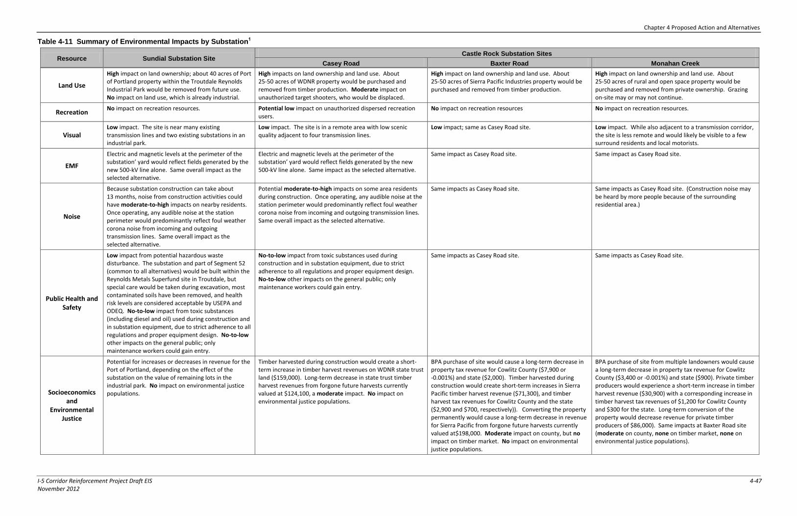
Chapter 4 Proposed Action and Alternatives
I-5 Corridor Reinforcement Project Draft EIS 4-47 November 2012
Table 4-11 Summary of Environmental Impacts by Substation1
Resource Sundial Substation Site Castle Rock Substation Sites
Casey Road Baxter Road Monahan Creek
Land Use
High impact on land ownership; about 40 acres of Port of Portland property within the Troutdale Reynolds Industrial Park would be removed from future use. No impact on land use, which is already industrial.
High impacts on land ownership and land use. About 25-50 acres of WDNR property would be purchased and removed from timber production. Moderate impact on unauthorized target shooters, who would be displaced.
High impact on land ownership and land use. About 25-50 acres of Sierra Pacific Industries property would be purchased and removed from timber production.
High impact on land ownership and land use. About 25-50 acres of rural and open space property would be purchased and removed from private ownership. Grazing on-site may or may not continue.
Recreation No impact on recreation resources. Potential low impact on unauthorized dispersed recreation
users. No impact on recreation resources No impact on recreation resources.
Visual Low impact. The site is near many existing transmission lines and two existing substations in an industrial park.
Low impact. The site is in a remote area with low scenic quality adjacent to four transmission lines.
Low impact; same as Casey Road site. Low impact. While also adjacent to a transmission corridor, the site is less remote and would likely be visible to a few surround residents and local motorists.
EMF
Electric and magnetic levels at the perimeter of the substation’ yard would reflect fields generated by the new 500-kV line alone. Same overall impact as the selected alternative.
Electric and magnetic levels at the perimeter of the substation’ yard would reflect fields generated by the new 500-kV line alone. Same impact as the selected alternative.
Same impact as Casey Road site. Same impact as Casey Road site.
Noise
Because substation construction can take about 13 months, noise from construction activities could have moderate-to-high impacts on nearby residents. Once operating, any audible noise at the station perimeter would predominantly reflect foul weather corona noise from incoming and outgoing transmission lines. Same overall impact as the selected alternative.
Potential moderate-to-high impacts on some area residents during construction. Once operating, any audible noise at the station perimeter would predominantly reflect foul weather corona noise from incoming and outgoing transmission lines. Same overall impact as the selected alternative.
Same impacts as Casey Road site. Same impacts as Casey Road site. (Construction noise may be heard by more people because of the surrounding residential area.)
Public Health and Safety
Low impact from potential hazardous waste disturbance. The substation and part of Segment 52 (common to all alternatives) would be built within the Reynolds Metals Superfund site in Troutdale, but special care would be taken during excavation, most contaminated soils have been removed, and health risk levels are considered acceptable by USEPA and ODEQ. No-to-low impact from toxic substances (including diesel and oil) used during construction and in substation equipment, due to strict adherence to all regulations and proper equipment design. No-to-low other impacts on the general public; only maintenance workers could gain entry.
No-to-low impact from toxic substances used during construction and in substation equipment, due to strict adherence to all regulations and proper equipment design. No-to-low other impacts on the general public; only maintenance workers could gain entry.
Same impacts as Casey Road site. Same impacts as Casey Road site.
Socioeconomics and
Environmental Justice
Potential for increases or decreases in revenue for the Port of Portland, depending on the effect of the substation on the value of remaining lots in the industrial park. No impact on environmental justice populations.
Timber harvested during construction would create a short-term increase in timber harvest revenues on WDNR state trust land ($159,000). Long-term decrease in state trust timber harvest revenues from forgone future harvests currently valued at $124,100, a moderate impact. No impact on environmental justice populations.
BPA purchase of site would cause a long-term decrease in property tax revenue for Cowlitz County ($7,900 or -0.001%) and state ($2,000). Timber harvested during construction would create short-term increases in Sierra Pacific timber harvest revenue ($71,300), and timber harvest tax revenues for Cowlitz County and the state ($2,900 and $700, respectively)). Converting the property permanently would cause a long-term decrease in revenue for Sierra Pacific from forgone future harvests currently valued at$198,000. Moderate impact on county, but no impact on timber market. No impact on environmental justice populations.
BPA purchase of site from multiple landowners would cause a long-term decrease in property tax revenue for Cowlitz County ($3,400 or -0.001%) and state ($900). Private timber producers would experience a short-term increase in timber harvest revenue ($30,900) with a corresponding increase in timber harvest tax revenues of $1,200 for Cowlitz County and $300 for the state. Long-term conversion of the property would decrease revenue for private timber producers of $86,000). Same impacts at Baxter Road site (moderate on county, none on timber market, none on environmental justice populations).
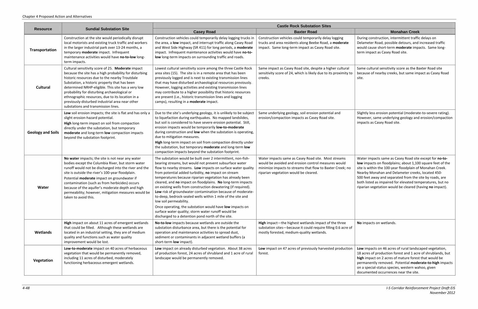
Chapter 4 Proposed Action and Alternatives
4-48 I-5 Corridor Reinforcement Project Draft EIS November 2012
Resource Sundial Substation Site Castle Rock Substation Sites
Casey Road Baxter Road Monahan Creek
Transportation
Construction at the site would periodically disrupt local motorists and existing truck traffic and workers in the larger industrial park over 13-24 months, a temporary moderate impact. Infrequent maintenance activities would have no-to-low long-term impacts.
Construction vehicles could temporarily delay logging trucks in the area, a low impact, and interrupt traffic along Casey Road and West Side Highway (SR 411) for long periods, a moderate impact. Infrequent maintenance activities would have no-to-low long-term impacts on surrounding traffic and roads.
Construction vehicles could temporarily delay logging trucks and area residents along Beebe Road, a moderate impact. Same long-term impact as Casey Road site.
During construction, intermittent traffic delays on Delameter Road, possible detours, and increased traffic would cause short-term moderate impacts. Same long-term impact as Casey Road site.
Cultural
Cultural sensitivity score of 25. Moderate impact because the site has a high probability for disturbing historic resources due to the nearby Troutdale Substation, a historic property that has been determined NRHP-eligible. This site has a very low probability for disturbing archaeological or ethnographic resources, due to its location in a previously-disturbed industrial area near other substations and transmission lines.
Lowest cultural sensitivity score among the three Castle Rock area sites (15). The site is in a remote area that has been previously logged and is next to existing transmission lines that may have disturbed archaeological resources previously. However, logging activities and existing transmission lines may contribute to a higher possibility that historic resources are present (i.e., historic transmission lines and logging camps), resulting in a moderate impact.
Same impact as Casey Road site, despite a higher cultural sensitivity score of 24, which is likely due to its proximity to creeks.
Same cultural sensitivity score as the Baxter Road site because of nearby creeks, but same impact as Casey Road site.
Geology and Soils
Low soil erosion impacts; the site is flat and has only a slight erosion-hazard potential.
High long-term impact on soil from compaction directly under the substation, but temporary moderate and long-term low compaction impacts beyond the substation footprint.
Due to the site’s underlying geology, it is unlikely to be subject to liquefaction during earthquakes. No mapped landslides, but soil is considered to have severe erosion potential. Still, erosion impacts would be temporarily low-to-moderate during construction and low when the substation is operating, due to mitigation measures.
High long-term impact on soil from compaction directly under the substation, but temporary moderate and long-term low compaction impacts beyond the substation footprint.
Same underlying geology, soil erosion potential and erosion/compaction impacts as Casey Road site.
Slightly less erosion potential (moderate-to-severe rating). However, same underlying geology and erosion/compaction impacts as Casey Road site.
Water
No water impacts; the site is not near any water bodies except the Columbia River, but storm water runoff would not be discharged into the river and the site is outside the river’s 100-year floodplain.
Potential moderate impact on groundwater if contamination (such as from herbicides) occurs because of the aquifer’s moderate depth and high permeability; however, mitigation measures would be taken to avoid this.
The substation would be built over 2 intermittent, non-fish-bearing streams, but would not prevent subsurface water flow to nearby streams. Low impacts on surface water quality from potential added turbidity, no impact on stream temperatures because riparian vegetation has already been cleared, and no impact on floodplains. No long-term impacts on existing wells from construction dewatering (if required). Low risk of groundwater contamination because of moderate-to-deep, bedrock-sealed wells within 1 mile of the site and low soil permeability.
Once operating, the substation would have low impacts on surface water quality; storm water runoff would be discharged to a detention pond north of the site.
Water impacts same as Casey Road site. Most streams would be avoided and erosion control measures would minimize impacts to streams that flow to Baxter Creek; no riparian vegetation would be cleared.
Water impacts same as Casey Road site except for no-to-low impacts on floodplains; about 1,100 square feet of the site is within the 100-year floodplain of Monahan Creek. Nearby Monahan and Delameter creeks, located 450-500 feet away and separated from the site by roads, are both listed as impaired for elevated temperatures, but no riparian vegetation would be cleared (having no impact).
Wetlands
High impact on about 11 acres of emergent wetlands that could be filled. Although these wetlands are located in an industrial setting, they are of medium quality and functions such as water quality improvement would be lost.
No-to-low impacts because wetlands are outside the substation disturbance area, but there is the potential for operation and maintenance activities to spread dust, sediment or contaminants in adjacent wetland buffers (a short-term low impact).
High impact—the highest wetlands impact of the three substation sites—because it could require filling 0.6 acre of mostly forested, medium-quality wetlands.
No impacts on wetlands.
Vegetation
Low-to-moderate impact on 40 acres of herbaceous vegetation that would be permanently removed, including 11 acres of disturbed, moderately functioning herbaceous emergent wetlands.
Low impact on already disturbed vegetation. About 38 acres of production forest, 24 acres of shrubland and 1 acre of rural landscape would be permanently removed.
Low impact on 47 acres of previously harvested production forest.
Low impacts on 46 acres of rural landscaped vegetation, 18 acres of production forest and 1 acre of shrublands, but high impact on 2 acres of mature forest that would be permanently removed. Potential moderate-to-high impacts on a special-status species, western wahoo, given documented occurrences near the site.
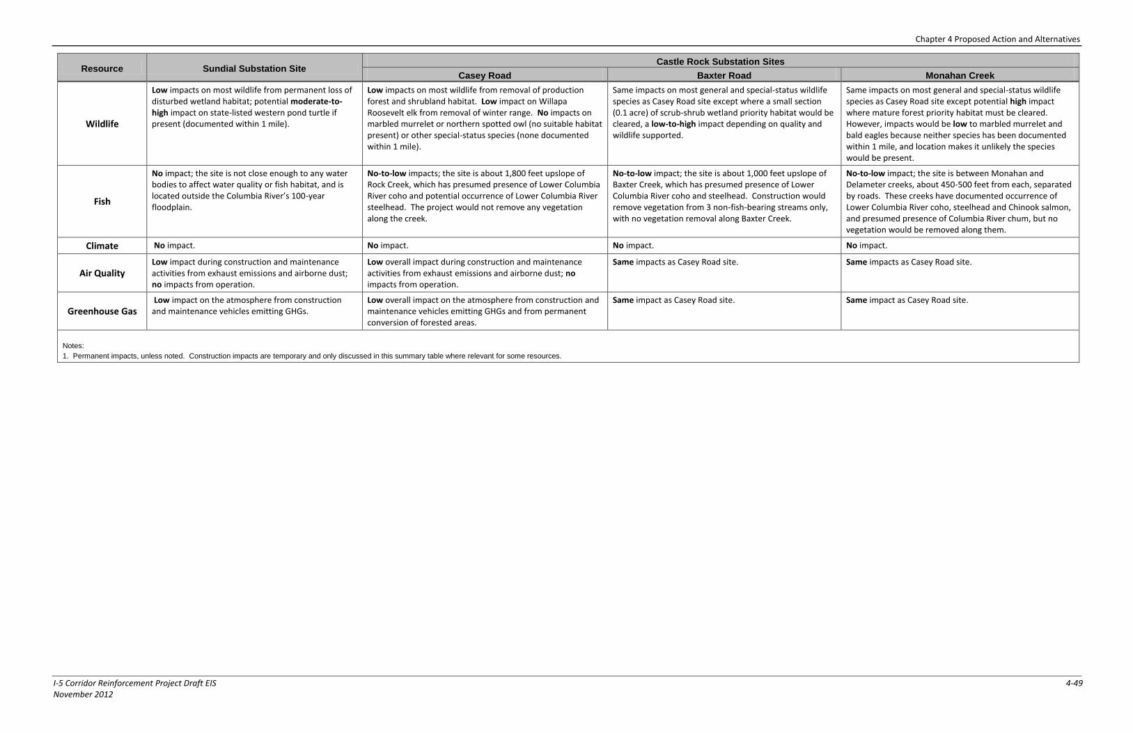
Chapter 4 Proposed Action and Alternatives
I-5 Corridor Reinforcement Project Draft EIS 4-49 November 2012
Resource Sundial Substation Site Castle Rock Substation Sites
Casey Road Baxter Road Monahan Creek
Wildlife
Low impacts on most wildlife from permanent loss of disturbed wetland habitat; potential moderate-to-high impact on state-listed western pond turtle if present (documented within 1 mile).
Low impacts on most wildlife from removal of production forest and shrubland habitat. Low impact on Willapa Roosevelt elk from removal of winter range. No impacts on marbled murrelet or northern spotted owl (no suitable habitat present) or other special-status species (none documented within 1 mile).
Same impacts on most general and special-status wildlife species as Casey Road site except where a small section (0.1 acre) of scrub-shrub wetland priority habitat would be cleared, a low-to-high impact depending on quality and wildlife supported.
Same impacts on most general and special-status wildlife species as Casey Road site except potential high impact where mature forest priority habitat must be cleared. However, impacts would be low to marbled murrelet and bald eagles because neither species has been documented within 1 mile, and location makes it unlikely the species would be present.
Fish
No impact; the site is not close enough to any water bodies to affect water quality or fish habitat, and is located outside the Columbia River’s 100-year floodplain.
No-to-low impacts; the site is about 1,800 feet upslope of Rock Creek, which has presumed presence of Lower Columbia River coho and potential occurrence of Lower Columbia River steelhead. The project would not remove any vegetation along the creek.
No-to-low impact; the site is about 1,000 feet upslope of Baxter Creek, which has presumed presence of Lower Columbia River coho and steelhead. Construction would remove vegetation from 3 non-fish-bearing streams only, with no vegetation removal along Baxter Creek.
No-to-low impact; the site is between Monahan and Delameter creeks, about 450-500 feet from each, separated by roads. These creeks have documented occurrence of Lower Columbia River coho, steelhead and Chinook salmon, and presumed presence of Columbia River chum, but no vegetation would be removed along them.
Climate No impact. No impact. No impact. No impact.
Air Quality Low impact during construction and maintenance activities from exhaust emissions and airborne dust; no impacts from operation.
Low overall impact during construction and maintenance activities from exhaust emissions and airborne dust; no impacts from operation.
Same impacts as Casey Road site. Same impacts as Casey Road site.
Greenhouse Gas Low impact on the atmosphere from construction and maintenance vehicles emitting GHGs.
Low overall impact on the atmosphere from construction and maintenance vehicles emitting GHGs and from permanent conversion of forested areas.
Same impact as Casey Road site. Same impact as Casey Road site.
Notes:
1. Permanent impacts, unless noted. Construction impacts are temporary and only discussed in this summary table where relevant for some resources.
Chapter 4 Proposed Action and Alternatives
4-50 I-5 Corridor Reinforcement Project Draft EIS November 2012
Page intentionally left blank