Embed Size (px)
Citation preview
Chapter 4 – Inventory & System Evaluation Page 1 of 68
Chapter 4: Inventory & System Evaluation 4.0 Introduction
While Chapter 2 outlined the overall airport classifications, Level 1 and Level 2 criteria, minimum service
level recommendations, IAP recommendations, and inclusion criteria for this 2012 system plan update, this Chapter is focused on defining how each airport in the system is meeting each of those criteria. An
inventory was conducted for each of the 69 airports to evaluate the system’s performance as a whole, and to create recommendations for future development within the system (Chapter 6). The inventory and analysis provided is divided into the following three groups:
• INDOT Level 1 Service Requirements,
• INDOT Minimum Service Level Recommendations, and
• INDOT Minimum Vertically Guided IAP Recommendations for Primary Runways.
Appendix G includes a facility evaluation sheet for each system airport, which provides an airport-specific
snapshot of how the requirements/recommendations are being met at the time of publication.
4.1 INDOT Level 1 Service Requirements
In addition to the criteria established by the FAA for inclusion in the ASSET categories, INDOT has
included seven additional criteria for each category. As detailed in Chapter 2, these criteria are not the same for each category, rather they are reflective of the services and facilities that airports should have in
each respective role:
• Airport Minimum Standards
• Pavement Maintenance Management Program
• Weather Reporting
• Runway Lights
• Full Parallel Taxiway or Comparable
• 24-Hour Fuel Availability
• Taxiway Lights

Chapter 4 – Inventory & System Evaluation Page 2 of 68
If an airport meets the criteria for its category, it is considered to be a “Level 1” airport. Any airport within a category that does not meet the criteria is considered to be a “Level 2” airport. Table 4-1
outlines the specific criteria requirements for each category.
Table 4-1 – INDOT Level 1 Airport Requirements
INDOT LEVEL 1 SERVICE REQUIREMENTS PRIMARY NATIONAL REGIONAL LOCAL BASIC
Minimum Standards Required Required Required Required Required
Pavement Maintenance Management Program Required Required Required Required Required
Weather Reporting Required Required Required Required Required
Runway Lights HIRL MIRL MIRL MIRL LIRL
Full Parallel Taxiway or Comparable Required Required Required Required
24-Hour Fuel Availability Required Required Required Required
Taxiway Lights Required Required Required Required
The following subsections provide a system-wide analysis for each of these requirements.
4.1.1 Minimum Standards
Minimum standards and operating procedures help protect the public and an airport from irresponsible and unsafe actions. The establishment of these standards can help encourage and promote activities that
contribute to quality of services provided to users of an airport.
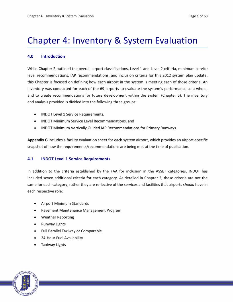
Minimum standards are required for all airport categories to be considered a Level 1 airport. While all airports in the Primary and National categories are meeting this criterion, airports in the other three
categories are not, as shown in Figure 4-1. The majority of Local and Basic airports do not have minimum standards. Overall, 36 airports in the system (or 52% of the system) are not meeting this requirement.
Table 4-2 includes a listing of all system airports. Those airports in bold text are not meeting the requirement.

Chapter 4 – Inventory & System Evaluation Page 3 of 68
Table 4-2 – INDOT Level 1 Requirement: Minimum Standards
Aviation Facility Associated City Category FAA ID Minimum Standards
Evansville Regional Evansville Primary EVV Y Ft. Wayne International Fort Wayne Primary FWA Y Indianapolis International Indianapolis Primary IND Y South Bend Regional South Bend Primary SBN Y Gary/Chicago Gary National GYY Y DeKalb County Auburn Regional GWB Y Monroe County Bloomington Regional BMG Y Columbus Municipal Columbus Regional BAK Y Elkhart Municipal Elkhart Regional EKM Y Goshen Municipal Goshen Regional GSH N Huntingburg Airport Huntingburg Regional HNB Y Eagle Creek Airpark Indianapolis Regional EYE Y Indianapolis Executive Indianapolis Regional TYQ Y Indianapolis Metropolitan Indianapolis Regional UMP Y Indianapolis Regional Indianapolis Regional MQJ Y Clark County Jeffersonville Regional JVY Y Purdue University Lafayette Regional LAF Y Marion Municipal Marion Regional MZZ Y Delaware County Muncie Regional MIE Y Porter County Regional Valparaiso Regional VPZ Y Warsaw Municipal Warsaw Regional ASW Y Anderson Municipal Anderson Local AID N Steuben Co.-Tri State Angola Local ANQ N Virgil I. Grissom Bedford Local BFR N Brazil-Clay County Brazil Local 0I2 N Crawfordsville Municipal Crawfordsville Local CFJ Y Smith Field Fort Wayne Local SMD Y Putnam County Greencastle Local 4I7 N
6%
69%
85%
0%10%20%30%40%50%60%70%80%90%
100%
Primary (4) National (1) Regional (16) Local (35) Basic (13)
Figure 4-1 - INDOT Level 1 Requirement: Minimum Standards
% Airports Meeting Target
% Airports Not Meeting Target
Chapter 4 – Inventory & System Evaluation Page 4 of 68
Table 4-2 – INDOT Level 1 Requirement: Minimum Standards
Aviation Facility Associated City Category FAA ID Minimum Standards
Greensburg-Decatur County Greensburg Local I34 N Griffith-Merrillville Griffith Local 05C N Huntington Municipal Huntington Local HHG N Greenwood Municipal Indianapolis Local HFY Y Hendricks County Indianapolis Local 2R2 Y Kendallville Municipal Kendallville Local C62 N Starke County Knox Local OXI N Kokomo Municipal Kokomo Local OKK Y LaPorte Municipal LaPorte Local PPO Y Madison Municipal Madison Local IMS N Michigan City Municipal Michigan City Local MGC N White County Monticello Local MCX N New Castle-Henry Co. New Castle Local UWL N North Vernon Municipal North Vernon Local OVO Y Paoli Municipal Paoli Local I42 N Peru Municipal Peru Local I76 N Plymouth Municipal Plymouth Local C65 N Portland Municipal Portland Local PLD N Jasper County Rensselaer Local RZL N Richmond Municipal Richmond Local RID N Salem Municipal Salem Local I83 N Freeman Municipal Seymour Local SER Y Shelbyville Municipal Shelbyville Local GEZ Y Sheridan Sheridan Local 5I4 N Sullivan County Sullivan Local SIV Y Terre Haute International Terre Haute Local HUF Y Wabash Municipal Wabash Local IWH N Daviess County Washington Local DCY N Clinton Clinton Basic 1I7 N Mettel Field Connersville Basic CEV N Delphi Municipal Delphi Basic 1I9 N Frankfort Municipal Frankfort Basic FKR Y French Lick Municipal French Lick Basic FRH N Ind. Downtown Heliport Indianapolis Basic 8A4 Y Kentland Municipal Kentland Basic 50I N Boone County Lebanon Basic 6I4 N Logansport Municipal Logansport Basic GGP N Fulton County Rochester Basic RCR N Perry County Municipal Tell City Basic TEL N Arens Field Winamac Basic RWN N Randolph County Winchester Basic I22 N
Note: Airports in BOLD text are not meeting the criteria.
Chapter 4 – Inventory & System Evaluation Page 5 of 68
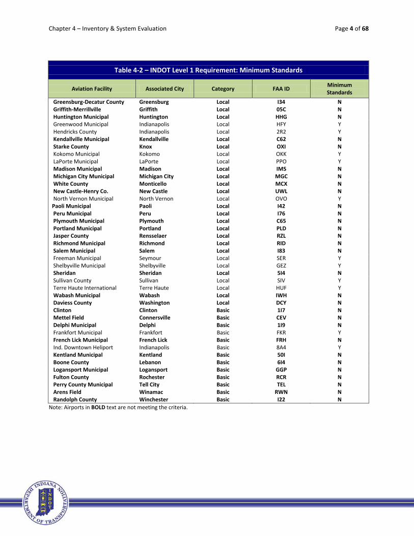
4.1.2 Pavement Maintenance Management Program
All airports should have a pavement maintenance management program in order to preserve their
existing pavements and plan for future maintenance that will be needed. Figure 4-2 shows the system is meeting this requirement very well with only 3% of Local airport category (one airport) and 8% of Basic airport category (one airport) not meeting it. Table 4-3 includes a listing of all system airports. Those
airports in bold text are not meeting this requirement.
Table 4-3 – INDOT Level 1 Requirement: Pavement Maintenance Management Program
Aviation Facility Associated City Category FAA ID Pavement Management Plan
Evansville Regional Evansville Primary EVV Y Ft. Wayne International Fort Wayne Primary FWA Y Indianapolis International Indianapolis Primary IND Y South Bend Regional South Bend Primary SBN Y Gary/Chicago Gary National GYY Y DeKalb County Auburn Regional GWB Y Monroe County Bloomington Regional BMG Y Columbus Municipal Columbus Regional BAK Y Elkhart Municipal Elkhart Regional EKM Y Goshen Municipal Goshen Regional GSH Y Huntingburg Airport Huntingburg Regional HNB Y Eagle Creek Airpark Indianapolis Regional EYE Y Indianapolis Executive Indianapolis Regional TYQ Y Indianapolis Metropolitan Indianapolis Regional UMP Y Indianapolis Regional Indianapolis Regional MQJ Y Clark County Jeffersonville Regional JVY Y
3% 8%
0%10%20%30%40%50%60%70%80%90%
100%
Primary (4) National (1) Regional (16) Local (35) Basic (13)
Figure 4-2 - INDOT Level 1 Requirement: Pavement Maintenance Management Program
% Airports Meeting Target
% Airports Not Meeting Target

Chapter 4 – Inventory & System Evaluation Page 6 of 68
Table 4-3 – INDOT Level 1 Requirement: Pavement Maintenance Management Program
Aviation Facility Associated City Category FAA ID Pavement Management Plan
Purdue University Lafayette Regional LAF Y Marion Municipal Marion Regional MZZ Y Delaware County Muncie Regional MIE Y Porter County Regional Valparaiso Regional VPZ Y Warsaw Municipal Warsaw Regional ASW Y Anderson Municipal Anderson Local AID Y Steuben Co.-Tri State Angola Local ANQ Y Virgil I. Grissom Bedford Local BFR Y Brazil-Clay County Brazil Local 0I2 Y Crawfordsville Municipal Crawfordsville Local CFJ Y Smith Field Fort Wayne Local SMD Y Putnam County Greencastle Local 4I7 Y Greensburg-Decatur County Greensburg Local I34 Y Griffith-Merrillville Griffith Local 05C Y Huntington Municipal Huntington Local HHG Y Greenwood Municipal Indianapolis Local HFY Y Hendricks County Indianapolis Local 2R2 Y Kendallville Municipal Kendallville Local C62 Y Starke County Knox Local OXI Y Kokomo Municipal Kokomo Local OKK Y LaPorte Municipal LaPorte Local PPO Y Madison Municipal Madison Local IMS Y Michigan City Municipal Michigan City Local MGC Y White County Monticello Local MCX Y New Castle-Henry Co. New Castle Local UWL Y North Vernon Municipal North Vernon Local OVO Y Paoli Municipal Paoli Local I42 Y Peru Municipal Peru Local I76 Y Plymouth Municipal Plymouth Local C65 Y Portland Municipal Portland Local PLD Y Jasper County Rensselaer Local RZL Y Richmond Municipal Richmond Local RID Y Salem Municipal Salem Local I83 Y Freeman Municipal Seymour Local SER Y Shelbyville Municipal Shelbyville Local GEZ Y Sheridan Sheridan Local 5I4 N Sullivan County Sullivan Local SIV Y Terre Haute International Terre Haute Local HUF Y Wabash Municipal Wabash Local IWH Y Daviess County Washington Local DCY Y Clinton Clinton Basic 1I7 Y Mettel Field Connersville Basic CEV Y Delphi Municipal Delphi Basic 1I9 Y Frankfort Municipal Frankfort Basic FKR Y French Lick Municipal French Lick Basic FRH Y Ind. Downtown Heliport Indianapolis Basic 8A4 Y Kentland Municipal Kentland Basic 50I Y Boone County Lebanon Basic 6I4 N Logansport Municipal Logansport Basic GGP Y
Chapter 4 – Inventory & System Evaluation Page 7 of 68
Table 4-3 – INDOT Level 1 Requirement: Pavement Maintenance Management Program
Aviation Facility Associated City Category FAA ID Pavement Management Plan
Fulton County Rochester Basic RCR Y Perry County Municipal Tell City Basic TEL Y Arens Field Winamac Basic RWN Y Randolph County Winchester Basic I22 Y
Note: Airports in BOLD text are not meeting the criteria.
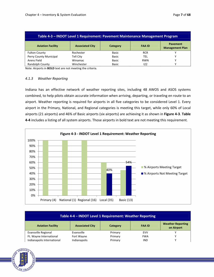
4.1.3 Weather Reporting
Indiana has an effective network of weather reporting sites, including 48 AWOS and ASOS systems combined, to help pilots obtain accurate information when arriving, departing, or traveling en route to an
airport. Weather reporting is required for airports in all five categories to be considered Level 1. Every airport in the Primary, National, and Regional categories is meeting this target, while only 60% of Local
airports (21 airports) and 46% of Basic airports (six airports) are achieving it as shown in Figure 4-3. Table 4-4 includes a listing of all system airports. Those airports in bold text are not meeting this requirement.
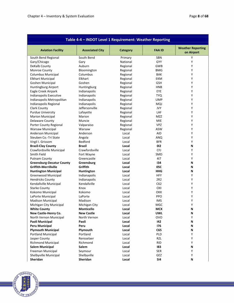
Table 4-4 – INDOT Level 1 Requirement: Weather Reporting
Aviation Facility Associated City Category FAA ID Weather Reporting on Airport
Evansville Regional Evansville Primary EVV Y Ft. Wayne International Fort Wayne Primary FWA Y Indianapolis International Indianapolis Primary IND Y
40%
54%
0%10%20%30%40%50%60%70%80%90%
100%
Primary (4) National (1) Regional (16) Local (35) Basic (13)
Figure 4-3 - INDOT Level 1 Requirement: Weather Reporting
% Airports Meeting Target
% Airports Not Meeting Target
Chapter 4 – Inventory & System Evaluation Page 8 of 68
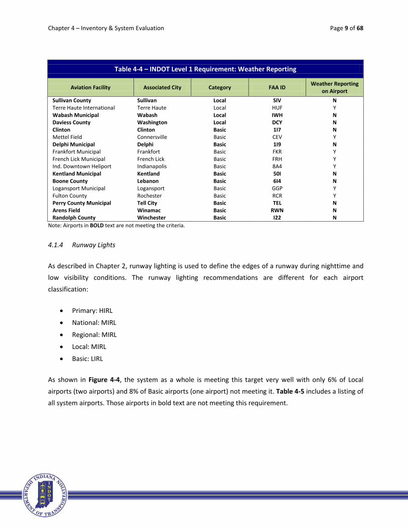
Table 4-4 – INDOT Level 1 Requirement: Weather Reporting
Aviation Facility Associated City Category FAA ID Weather Reporting on Airport
South Bend Regional South Bend Primary SBN Y Gary/Chicago Gary National GYY Y DeKalb County Auburn Regional GWB Y Monroe County Bloomington Regional BMG Y Columbus Municipal Columbus Regional BAK Y Elkhart Municipal Elkhart Regional EKM Y Goshen Municipal Goshen Regional GSH Y Huntingburg Airport Huntingburg Regional HNB Y Eagle Creek Airpark Indianapolis Regional EYE Y Indianapolis Executive Indianapolis Regional TYQ Y Indianapolis Metropolitan Indianapolis Regional UMP Y Indianapolis Regional Indianapolis Regional MQJ Y Clark County Jeffersonville Regional JVY Y Purdue University Lafayette Regional LAF Y Marion Municipal Marion Regional MZZ Y Delaware County Muncie Regional MIE Y Porter County Regional Valparaiso Regional VPZ Y Warsaw Municipal Warsaw Regional ASW Y Anderson Municipal Anderson Local AID Y Steuben Co.-Tri State Angola Local ANQ Y Virgil I. Grissom Bedford Local BFR Y Brazil-Clay County Brazil Local 0I2 N Crawfordsville Municipal Crawfordsville Local CFJ Y Smith Field Fort Wayne Local SMD Y Putnam County Greencastle Local 4I7 Y Greensburg-Decatur County Greensburg Local I34 N Griffith-Merrillville Griffith Local 05C N Huntington Municipal Huntington Local HHG N Greenwood Municipal Indianapolis Local HFY Y Hendricks County Indianapolis Local 2R2 Y Kendallville Municipal Kendallville Local C62 Y Starke County Knox Local OXI Y Kokomo Municipal Kokomo Local OKK Y LaPorte Municipal LaPorte Local PPO Y Madison Municipal Madison Local IMS Y Michigan City Municipal Michigan City Local MGC Y White County Monticello Local MCX N New Castle-Henry Co. New Castle Local UWL N North Vernon Municipal North Vernon Local OVO Y Paoli Municipal Paoli Local I42 N Peru Municipal Peru Local I76 N Plymouth Municipal Plymouth Local C65 N Portland Municipal Portland Local PLD Y Jasper County Rensselaer Local RZL Y Richmond Municipal Richmond Local RID Y Salem Municipal Salem Local I83 N Freeman Municipal Seymour Local SER Y Shelbyville Municipal Shelbyville Local GEZ Y Sheridan Sheridan Local 5I4 N
Chapter 4 – Inventory & System Evaluation Page 9 of 68
Table 4-4 – INDOT Level 1 Requirement: Weather Reporting
Aviation Facility Associated City Category FAA ID Weather Reporting on Airport
Sullivan County Sullivan Local SIV N Terre Haute International Terre Haute Local HUF Y Wabash Municipal Wabash Local IWH N Daviess County Washington Local DCY N Clinton Clinton Basic 1I7 N Mettel Field Connersville Basic CEV Y Delphi Municipal Delphi Basic 1I9 N Frankfort Municipal Frankfort Basic FKR Y French Lick Municipal French Lick Basic FRH Y Ind. Downtown Heliport Indianapolis Basic 8A4 Y Kentland Municipal Kentland Basic 50I N Boone County Lebanon Basic 6I4 N Logansport Municipal Logansport Basic GGP Y Fulton County Rochester Basic RCR Y Perry County Municipal Tell City Basic TEL N Arens Field Winamac Basic RWN N Randolph County Winchester Basic I22 N
Note: Airports in BOLD text are not meeting the criteria.
4.1.4 Runway Lights
As described in Chapter 2, runway lighting is used to define the edges of a runway during nighttime and low visibility conditions. The runway lighting recommendations are different for each airport
classification:
• Primary: HIRL
• National: MIRL
• Regional: MIRL
• Local: MIRL
• Basic: LIRL
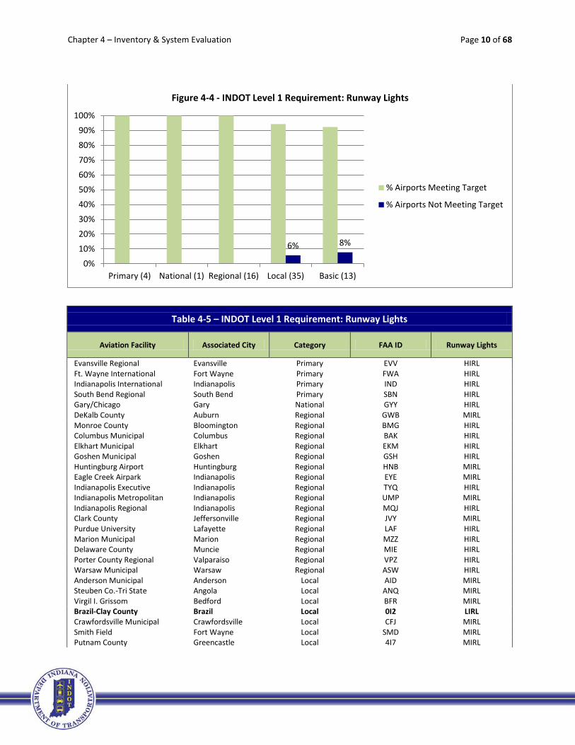
As shown in Figure 4-4, the system as a whole is meeting this target very well with only 6% of Local
airports (two airports) and 8% of Basic airports (one airport) not meeting it. Table 4-5 includes a listing of all system airports. Those airports in bold text are not meeting this requirement.
Chapter 4 – Inventory & System Evaluation Page 10 of 68
Table 4-5 – INDOT Level 1 Requirement: Runway Lights
Aviation Facility Associated City Category FAA ID Runway Lights
Evansville Regional Evansville Primary EVV HIRL Ft. Wayne International Fort Wayne Primary FWA HIRL Indianapolis International Indianapolis Primary IND HIRL South Bend Regional South Bend Primary SBN HIRL Gary/Chicago Gary National GYY HIRL DeKalb County Auburn Regional GWB MIRL Monroe County Bloomington Regional BMG HIRL Columbus Municipal Columbus Regional BAK HIRL Elkhart Municipal Elkhart Regional EKM HIRL Goshen Municipal Goshen Regional GSH HIRL Huntingburg Airport Huntingburg Regional HNB MIRL Eagle Creek Airpark Indianapolis Regional EYE MIRL Indianapolis Executive Indianapolis Regional TYQ HIRL Indianapolis Metropolitan Indianapolis Regional UMP MIRL Indianapolis Regional Indianapolis Regional MQJ HIRL Clark County Jeffersonville Regional JVY MIRL Purdue University Lafayette Regional LAF HIRL Marion Municipal Marion Regional MZZ HIRL Delaware County Muncie Regional MIE HIRL Porter County Regional Valparaiso Regional VPZ HIRL Warsaw Municipal Warsaw Regional ASW HIRL Anderson Municipal Anderson Local AID MIRL Steuben Co.-Tri State Angola Local ANQ MIRL Virgil I. Grissom Bedford Local BFR MIRL Brazil-Clay County Brazil Local 0I2 LIRL Crawfordsville Municipal Crawfordsville Local CFJ MIRL Smith Field Fort Wayne Local SMD MIRL Putnam County Greencastle Local 4I7 MIRL
6% 8%
0%10%20%30%40%50%60%70%80%90%
100%
Primary (4) National (1) Regional (16) Local (35) Basic (13)
Figure 4-4 - INDOT Level 1 Requirement: Runway Lights
% Airports Meeting Target
% Airports Not Meeting Target

Chapter 4 – Inventory & System Evaluation Page 11 of 68
Table 4-5 – INDOT Level 1 Requirement: Runway Lights
Aviation Facility Associated City Category FAA ID Runway Lights
Greensburg-Decatur County Greensburg Local I34 MIRL Griffith-Merrillville Griffith Local 05C MIRL Huntington Municipal Huntington Local HHG MIRL Greenwood Municipal Indianapolis Local HFY HIRL Hendricks County Indianapolis Local 2R2 MIRL Kendallville Municipal Kendallville Local C62 MIRL Starke County Knox Local OXI MIRL Kokomo Municipal Kokomo Local OKK HIRL LaPorte Municipal LaPorte Local PPO MIRL Madison Municipal Madison Local IMS HIRL Michigan City Municipal Michigan City Local MGC MIRL White County Monticello Local MCX MIRL New Castle-Henry Co. New Castle Local UWL MIRL North Vernon Municipal North Vernon Local OVO MIRL Paoli Municipal Paoli Local I42 MIRL Peru Municipal Peru Local I76 MIRL Plymouth Municipal Plymouth Local C65 MIRL Portland Municipal Portland Local PLD MIRL Jasper County Rensselaer Local RZL MIRL Richmond Municipal Richmond Local RID MIRL Salem Municipal Salem Local I83 MIRL Freeman Municipal Seymour Local SER MIRL Shelbyville Municipal Shelbyville Local GEZ MIRL Sheridan Sheridan Local 5I4 NON-STND Sullivan County Sullivan Local SIV MIRL Terre Haute International Terre Haute Local HUF HIRL Wabash Municipal Wabash Local IWH MIRL Daviess County Washington Local DCY MIRL Clinton Clinton Basic 1I7 NO Mettel Field Connersville Basic CEV MIRL Delphi Municipal Delphi Basic 1I9 MIRL Frankfort Municipal Frankfort Basic FKR MIRL French Lick Municipal French Lick Basic FRH MIRL Ind. Downtown Heliport Indianapolis Basic 8A4 Yes Kentland Municipal Kentland Basic 50I HIRL Boone County Lebanon Basic 6I4 LIRL NSTD Logansport Municipal Logansport Basic GGP MIRL Fulton County Rochester Basic RCR MIRL Perry County Municipal Tell City Basic TEL MIRL Arens Field Winamac Basic RWN LIRL Randolph County Winchester Basic I22 MIRL
Note: Airports in BOLD text are not meeting the criteria.
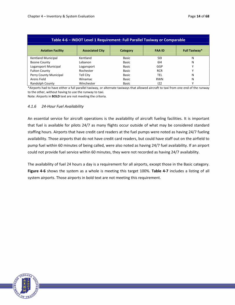
4.1.5 Full Parallel Taxiway or Comparable
Parallel taxiways are aligned parallel to a runway and are designed to increase safety and capacity by
minimizing the time an aircraft occupies the runway when maneuvering before takeoff or after landing.

Chapter 4 – Inventory & System Evaluation Page 12 of 68
Full parallel taxiways extend the entire length of a runway,y providing access to each runway end. While some airports did not have a standard parallel taxiway at the time of the inventory, they did have
alternate taxiways that allowed aircraft to taxi from one end of the runway to the other, without having to use the runway to taxi. Airports with this sort of configuration were considered to have a comparable
taxiway.
A full parallel taxiway (or comparable) is required for each airport classification, except Basic airports. Figure 4-5 shows 11 airports (31%) in the Local category are not meeting this target. Table 4-6 includes a
listing of all system airports. Those airports in bold text are not meeting this requirement.
Table 4-6 – INDOT Level 1 Requirement: Full Parallel Taxiway or Comparable
Aviation Facility Associated City Category FAA ID Full Taxiway*
Evansville Regional Evansville Primary EVV Y Ft. Wayne International Fort Wayne Primary FWA Y Indianapolis International Indianapolis Primary IND Y South Bend Regional South Bend Primary SBN Y Gary/Chicago Gary National GYY Y DeKalb County Auburn Regional GWB Y Monroe County Bloomington Regional BMG Y Columbus Municipal Columbus Regional BAK Y Elkhart Municipal Elkhart Regional EKM Y Goshen Municipal Goshen Regional GSH Y Huntingburg Airport Huntingburg Regional HNB Y Eagle Creek Airpark Indianapolis Regional EYE Y Indianapolis Executive Indianapolis Regional TYQ Y
31%
0%10%20%30%40%50%60%70%80%90%
100%
Primary (4) National (1) Regional (16) Local (35)
Figure 4-5 - INDOT Level 1 Requirement: Full Parallel Taxiway or Comparable
% Airports Meeting Target
% Airports Not Meeting Target

Chapter 4 – Inventory & System Evaluation Page 13 of 68
Table 4-6 – INDOT Level 1 Requirement: Full Parallel Taxiway or Comparable
Aviation Facility Associated City Category FAA ID Full Taxiway*
Indianapolis Metropolitan Indianapolis Regional UMP Y Indianapolis Regional Indianapolis Regional MQJ Y Clark County Jeffersonville Regional JVY Y Purdue University Lafayette Regional LAF Y Marion Municipal Marion Regional MZZ Y Delaware County Muncie Regional MIE Y Porter County Regional Valparaiso Regional VPZ Y Warsaw Municipal Warsaw Regional ASW Y Anderson Municipal Anderson Local AID Y Steuben Co.-Tri State Angola Local ANQ Y Virgil I. Grissom Bedford Local BFR N Brazil-Clay County Brazil Local 0I2 N Crawfordsville Municipal Crawfordsville Local CFJ Y Smith Field Fort Wayne Local SMD N Putnam County Greencastle Local 4I7 Y Greensburg-Decatur County Greensburg Local I34 N Griffith-Merrillville Griffith Local 05C N Huntington Municipal Huntington Local HHG Y Greenwood Municipal Indianapolis Local HFY Y Hendricks County Indianapolis Local 2R2 Y Kendallville Municipal Kendallville Local C62 Y Starke County Knox Local OXI Y Kokomo Municipal Kokomo Local OKK Y LaPorte Municipal LaPorte Local PPO Y Madison Municipal Madison Local IMS Y Michigan City Municipal Michigan City Local MGC Y White County Monticello Local MCX Y New Castle-Henry Co. New Castle Local UWL N North Vernon Municipal North Vernon Local OVO Y Paoli Municipal Paoli Local I42 N Peru Municipal Peru Local I76 Y Plymouth Municipal Plymouth Local C65 N Portland Municipal Portland Local PLD Y Jasper County Rensselaer Local RZL Y Richmond Municipal Richmond Local RID Y Salem Municipal Salem Local I83 N Freeman Municipal Seymour Local SER Y Shelbyville Municipal Shelbyville Local GEZ Y Sheridan Sheridan Local 5I4 N Sullivan County Sullivan Local SIV Y Terre Haute International Terre Haute Local HUF Y Wabash Municipal Wabash Local IWH Y Daviess County Washington Local DCY N Clinton Clinton Basic 1I7 N Mettel Field Connersville Basic CEV Y Delphi Municipal Delphi Basic 1I9 N Frankfort Municipal Frankfort Basic FKR N French Lick Municipal French Lick Basic FRH N Ind. Downtown Heliport Indianapolis Basic 8A4 NA
Chapter 4 – Inventory & System Evaluation Page 14 of 68
Table 4-6 – INDOT Level 1 Requirement: Full Parallel Taxiway or Comparable
Aviation Facility Associated City Category FAA ID Full Taxiway*
Kentland Municipal Kentland Basic 50I N Boone County Lebanon Basic 6I4 N Logansport Municipal Logansport Basic GGP Y Fulton County Rochester Basic RCR Y Perry County Municipal Tell City Basic TEL N Arens Field Winamac Basic RWN N Randolph County Winchester Basic I22 Y
*Airports had to have either a full parallel taxiway, or alternate taxiways that allowed aircraft to taxi from one end of the runway to the other, without having to use the runway to taxi. Note: Airports in BOLD text are not meeting the criteria.
4.1.6 24-Hour Fuel Availability
An essential service for aircraft operations is the availability of aircraft fueling facilities. It is important that fuel is available for pilots 24/7 as many flights occur outside of what may be considered standard
staffing hours. Airports that have credit card readers at the fuel pumps were noted as having 24/7 fueling availability. Those airports that do not have credit card readers, but could have staff out on the airfield to
pump fuel within 60 minutes of being called, were also noted as having 24/7 fuel availability. If an airport could not provide fuel service within 60 minutes, they were not recorded as having 24/7 availability.
The availability of fuel 24 hours a day is a requirement for all airports, except those in the Basic category.
Figure 4-6 shows the system as a whole is meeting this target 100%. Table 4-7 includes a listing of all system airports. Those airports in bold text are not meeting this requirement.

Chapter 4 – Inventory & System Evaluation Page 15 of 68
Table 4-7 – INDOT Level 1 Requirement: 24 Hour Fuel Availability
Aviation Facility Associated City Category FAA ID 24-Hour Fuel Service
Evansville Regional Evansville Primary EVV Y Ft. Wayne International Fort Wayne Primary FWA Y Indianapolis International Indianapolis Primary IND Y South Bend Regional South Bend Primary SBN Y Gary/Chicago Gary National GYY Y DeKalb County Auburn Regional GWB Y Monroe County Bloomington Regional BMG Y Columbus Municipal Columbus Regional BAK Y Elkhart Municipal Elkhart Regional EKM Y Goshen Municipal Goshen Regional GSH Y Huntingburg Airport Huntingburg Regional HNB Y Eagle Creek Airpark Indianapolis Regional EYE Y Indianapolis Executive Indianapolis Regional TYQ Y Indianapolis Metropolitan Indianapolis Regional UMP Y Indianapolis Regional Indianapolis Regional MQJ Y Clark County Jeffersonville Regional JVY Y Purdue University Lafayette Regional LAF Y Marion Municipal Marion Regional MZZ Y Delaware County Muncie Regional MIE Y Porter County Regional Valparaiso Regional VPZ Y Warsaw Municipal Warsaw Regional ASW Y Anderson Municipal Anderson Local AID Y Steuben Co.-Tri State Angola Local ANQ Y Virgil I. Grissom Bedford Local BFR Y Brazil-Clay County Brazil Local 0I2 Y Crawfordsville Municipal Crawfordsville Local CFJ Y Smith Field Fort Wayne Local SMD Y Putnam County Greencastle Local 4I7 Y
0%10%20%30%40%50%60%70%80%90%
100%
Primary (4) National (1) Regional (16) Local (35)
Figure 4-6 - INDOT Level 1 Requirement: 24-Hour Fuel Availability
% Airports Meeting Target
% Airports Not Meeting Target

Chapter 4 – Inventory & System Evaluation Page 16 of 68
Table 4-7 – INDOT Level 1 Requirement: 24 Hour Fuel Availability
Aviation Facility Associated City Category FAA ID 24-Hour Fuel Service
Greensburg-Decatur County Greensburg Local I34 Y Griffith-Merrillville Griffith Local 05C Y Huntington Municipal Huntington Local HHG Y Greenwood Municipal Indianapolis Local HFY Y Hendricks County Indianapolis Local 2R2 Y Kendallville Municipal Kendallville Local C62 Y Starke County Knox Local OXI Y Kokomo Municipal Kokomo Local OKK Y LaPorte Municipal LaPorte Local PPO Y Madison Municipal Madison Local IMS Y Michigan City Municipal Michigan City Local MGC Y White County Monticello Local MCX Y New Castle-Henry Co. New Castle Local UWL Y North Vernon Municipal North Vernon Local OVO Y Paoli Municipal Paoli Local I42 Y Peru Municipal Peru Local I76 Y Plymouth Municipal Plymouth Local C65 Y Portland Municipal Portland Local PLD Y Jasper County Rensselaer Local RZL Y Richmond Municipal Richmond Local RID Y Salem Municipal Salem Local I83 Y Freeman Municipal Seymour Local SER Y Shelbyville Municipal Shelbyville Local GEZ Y Sheridan Sheridan Local 5I4 Y Sullivan County Sullivan Local SIV Y Terre Haute International Terre Haute Local HUF Y Wabash Municipal Wabash Local IWH Y Daviess County Washington Local DCY Y Clinton Clinton Basic 1I7 N Mettel Field Connersville Basic CEV Y Delphi Municipal Delphi Basic 1I9 Y Frankfort Municipal Frankfort Basic FKR Y French Lick Municipal French Lick Basic FRH Y Ind. Downtown Heliport Indianapolis Basic 8A4 Y Kentland Municipal Kentland Basic 50I Y Boone County Lebanon Basic 6I4 N Logansport Municipal Logansport Basic GGP Y Fulton County Rochester Basic RCR Y Perry County Municipal Tell City Basic TEL Y Arens Field Winamac Basic RWN Y Randolph County Winchester Basic I22 Y
Note: Airports in BOLD text are not meeting the criteria.

Chapter 4 – Inventory & System Evaluation Page 17 of 68
4.1.7 Taxiway Lights
As detailed in Chapter 2, taxiway lighting is utilized to illuminate the edge of taxiways in nighttime and
low-visibility conditions. Taxiway lighting is required for all airports to be considered Level 1, except for those classified as Basic. Figure 4-7 shows there are a significant number of Local airports that are not meeting this target; 25 of the 35 airports in this category (71%) do not have taxiway lighting. Primary and
National airports are meeting this target 100%. Table 4-8 includes a listing of all system airports. Those airports in bold text are not meeting this requirement.
Table 4-8 - INDOT Level 1 Requirement: Taxiway Lights
Aviation Facility Associated City Category FAA ID Taxiway Lights
Evansville Regional Evansville Primary EVV Y Ft. Wayne International Fort Wayne Primary FWA Y Indianapolis International Indianapolis Primary IND Y South Bend Regional South Bend Primary SBN Y Gary/Chicago Gary National GYY Y DeKalb County Auburn Regional GWB Y Monroe County Bloomington Regional BMG Y Columbus Municipal Columbus Regional BAK Y Elkhart Municipal Elkhart Regional EKM Y Goshen Municipal Goshen Regional GSH N Huntingburg Airport Huntingburg Regional HNB Y Eagle Creek Airpark Indianapolis Regional EYE Y Indianapolis Executive Indianapolis Regional TYQ Y Indianapolis Metropolitan Indianapolis Regional UMP Y
13%
71%
0%10%20%30%40%50%60%70%80%90%
100%
Primary (4) National (1) Regional (16) Local (35)
Figure 4-7 - INDOT Level 1 Requirement: Taxiway Lights
% Airports Meeting Target
% Airports Not Meeting Target

Chapter 4 – Inventory & System Evaluation Page 18 of 68
Table 4-8 - INDOT Level 1 Requirement: Taxiway Lights
Aviation Facility Associated City Category FAA ID Taxiway Lights
Indianapolis Regional Indianapolis Regional MQJ Y Clark County Jeffersonville Regional JVY Y Purdue University Lafayette Regional LAF Y Marion Municipal Marion Regional MZZ Y Delaware County Muncie Regional MIE Y Porter County Regional Valparaiso Regional VPZ Y Warsaw Municipal Warsaw Regional ASW N Anderson Municipal Anderson Local AID Y Steuben Co.-Tri State Angola Local ANQ N Virgil I. Grissom Bedford Local BFR NA Brazil-Clay County Brazil Local 0I2 NA Crawfordsville Municipal Crawfordsville Local CFJ N Smith Field Fort Wayne Local SMD NA Putnam County Greencastle Local 4I7 Y Greensburg-Decatur County Greensburg Local I34 NA Griffith-Merrillville Griffith Local 05C N Huntington Municipal Huntington Local HHG N Greenwood Municipal Indianapolis Local HFY Y Hendricks County Indianapolis Local 2R2 Y Kendallville Municipal Kendallville Local C62 N Starke County Knox Local OXI Y Kokomo Municipal Kokomo Local OKK Y LaPorte Municipal LaPorte Local PPO N Madison Municipal Madison Local IMS N Michigan City Municipal Michigan City Local MGC N White County Monticello Local MCX N New Castle-Henry Co. New Castle Local UWL N North Vernon Municipal North Vernon Local OVO Y Paoli Municipal Paoli Local I42 NA Peru Municipal Peru Local I76 Y Plymouth Municipal Plymouth Local C65 NA Portland Municipal Portland Local PLD N Jasper County Rensselaer Local RZL Y Richmond Municipal Richmond Local RID N Salem Municipal Salem Local I83 N Freeman Municipal Seymour Local SER N Shelbyville Municipal Shelbyville Local GEZ N Sheridan Sheridan Local 5I4 NA Sullivan County Sullivan Local SIV Y Terre Haute International Terre Haute Local HUF Y Wabash Municipal Wabash Local IWH N Daviess County Washington Local DCY N Clinton Clinton Basic 1I7 NA Mettel Field Connersville Basic CEV N Delphi Municipal Delphi Basic 1I9 NA Frankfort Municipal Frankfort Basic FKR NA French Lick Municipal French Lick Basic FRH Y Ind. Downtown Heliport Indianapolis Basic 8A4 NA Kentland Municipal Kentland Basic 50I NA

Chapter 4 – Inventory & System Evaluation Page 19 of 68
Table 4-8 - INDOT Level 1 Requirement: Taxiway Lights
Aviation Facility Associated City Category FAA ID Taxiway Lights
Boone County Lebanon Basic 6I4 N Logansport Municipal Logansport Basic GGP N Fulton County Rochester Basic RCR N Perry County Municipal Tell City Basic TEL N Arens Field Winamac Basic RWN N Randolph County Winchester Basic I22 N
Note: Airports in BOLD text are not meeting the criteria.
Chapter 4 – Inventory & System Evaluation Page 20 of 68
4.2 INDOT Minimum Service Level Recommendations
This section of the system inventory includes the second group of airport criteria – the INDOT Minimum
Service Level Recommendations. These have been developed to enhance the service level provided in each category. Please note that these are minimum recommendations and not requirements. Not
meeting or exceeding these recommendations may be justified based on local conditions. Table 4-9 identifies the minimum service level recommendations for each airport category. Each of these are
inventoried and evaluated in the following subsections.
Table 4-9 – INDOT Recommended Minimum Service Level Goals
INDOT MINIMUM SERVICE LEVEL RECOMMENDATIONS1 PRIMARY NATIONAL REGIONAL LOCAL BASIC
Primary Runway Length (ft.) 7,000 7,000 5,000 - 7,000 3,400 - 5,000 3,400 Primary Runway Strength (SW2 or DW3)
100,000 SW 175,000 DW 100,000 60,000 30,000 12,500
Primary Runway Grooving4 Grooving Grooving Grooving Grooving Primary Runway End Identifier Lights5* REILs (If no AL) REILs (If no AL) REILs (If no AL) REILs
Primary Runway Visual Slope Indicators6 * or Approach Lights7 *
AL AL VSI or
AL (Recommended)
VSI
Perimeter Fencing Fencing Fencing Fencing Fencing Fencing
Zoning or Land Use Coordination Zoning/Coord. Zoning/Coord. Zoning/Coord. Zoning/Coord. Zoning/Coord.
NOTES, ACRONYMS, AND GLOSSARY 1 The following recommendations represent the minimum goal for at least one end of the primary runway.
Attaining greater may be justified. 2 SW – Single wheel gear. 3 DW – Dual wheel gear. 4 Grooving – Runway grooves are small linear cuts on a runway pavement surface which provide a way for water
to escape under aircraft tires traveling at high speed, reducing the hydroplaning effect when water is present on a runway. These grooves allow aircraft to maintain a higher degree of contact with the pavement surface when standing water is present to provide sufficient directional and braking control.
5 REILs – Runway end identifier lights generally provide rapid and positive identification of the end of the runway to the pilot.
6 VSI – Visual slope indicators – generally provide visual glide slope guidance to pilots in non-precision approaches environment.
7 AL – Approach lights generally provide the basic means for the pilot to transition from instrument flight to visual flight for landing. They can provide the pilot with visual information on runway alignment, height perception, role guidance, and horizontal references during these times.
* Recommendation for minimum of one (1) runway end.

Chapter 4 – Inventory & System Evaluation Page 21 of 68
4.2.1 Primary Runway Length
The recommended length of a runway is based upon the performance characteristics of the most
demanding aircraft type intended to use an airport. Information provided by aircraft manufacturers and FAA AC 150/5325-4, Runway Length Requirements for Airport Design, provide guidance and
recommendations to determine the preferred length of a runway. The primary runway is typically the longest runway capable of meeting the landing and takeoff distance requirements of the most
demanding aircraft operating at an airport. While each airport’s local conditions and most demanding aircraft are different, general length targets for the primary runway for each category have been
established as part of this ISASP update:
• Primary: 7,000 feet
• National: 7,000 feet
• Regional: 5,000-7,000 feet
• Local: 3,400-5,000 feet
• Basic: 3,400 feet
Figure 4-8 indicates the percentage of airports, per category, meeting their individual primary runway
length target. As the data shows, the majority of airports within each category are meeting their runway length target. Regional, Local, and Basic airports are those that require improvements. Thirteen percent
of Regional airports (two airports), 11% of Local airports (four airports), and 8% of Basic airports (one airport) are not meeting this recommendation. Table 4-8 includes a listing of all system airports, and the length of their primary runway. Those airports in bold text are not meeting this recommendation.

Chapter 4 – Inventory & System Evaluation Page 22 of 68
Table 4-9 – INDOT Minimum Service Level Recommendation: Primary Runway Length
Aviation Facility Associated City Category FAA ID Runway Length
Evansville Regional Evansville Primary EVV 8,020 Ft. Wayne International Fort Wayne Primary FWA 11,981 Indianapolis International Indianapolis Primary IND 11,200 South Bend Regional South Bend Primary SBN 8,414 Gary/Chicago Gary National GYY 7,003 DeKalb County Auburn Regional GWB 5,000 Monroe County Bloomington Regional BMG 6,500 Columbus Municipal Columbus Regional BAK 6,400 Elkhart Municipal Elkhart Regional EKM 6,500 Goshen Municipal Goshen Regional GSH 6,050 Huntingburg Airport Huntingburg Regional HNB 5,000 Eagle Creek Airpark Indianapolis Regional EYE 4,200 Indianapolis Executive Indianapolis Regional TYQ 5,500 Indianapolis Metropolitan Indianapolis Regional UMP 3,850 Indianapolis Regional Indianapolis Regional MQJ 5,500 Clark County Jeffersonville Regional JVY 5,500 Purdue University Lafayette Regional LAF 6,600 Marion Municipal Marion Regional MZZ 6,000 Delaware County Muncie Regional MIE 6,500 Porter County Regional Valparaiso Regional VPZ 7,001 Warsaw Municipal Warsaw Regional ASW 6,002 Anderson Municipal Anderson Local AID 5,400 Steuben Co.-Tri State Angola Local ANQ 4,540 Virgil I. Grissom Bedford Local BFR 4,501 Brazil-Clay County Brazil Local 0I2 2,941 Crawfordsville Municipal Crawfordsville Local CFJ 4,500 Smith Field Fort Wayne Local SMD 3,124 Putnam County Greencastle Local 4I7 4,987
13% 11% 8%
0%10%20%30%40%50%60%70%80%90%
100%
Primary (4) National (1) Regional (16) Local (35) Basic (13)
Figure 4-8 - INDOT Minimum Service Level Recommendation: Primary Runway Length
% Airports Meeting Target
% Airports Not Meeting Target

Chapter 4 – Inventory & System Evaluation Page 23 of 68
Table 4-9 – INDOT Minimum Service Level Recommendation: Primary Runway Length
Aviation Facility Associated City Category FAA ID Runway Length
Greensburg-Decatur County Greensburg Local I34 3,433 Griffith-Merrillville Griffith Local 05C 4,900 Huntington Municipal Huntington Local HHG 5,003 Greenwood Municipal Indianapolis Local HFY 4,901 Hendricks County Indianapolis Local 2R2 4,400 Kendallville Municipal Kendallville Local C62 4,400 Starke County Knox Local OXI 4,401 Kokomo Municipal Kokomo Local OKK 5,201 LaPorte Municipal LaPorte Local PPO 5,000 Madison Municipal Madison Local IMS 5,000 Michigan City Municipal Michigan City Local MGC 4,100 White County Monticello Local MCX 4,002 New Castle-Henry Co. New Castle Local UWL 4,002 North Vernon Municipal North Vernon Local OVO 5,002 Paoli Municipal Paoli Local I42 2,793 Peru Municipal Peru Local I76 4,400 Plymouth Municipal Plymouth Local C65 4,400 Portland Municipal Portland Local PLD 4,002 Jasper County Rensselaer Local RZL 4,001 Richmond Municipal Richmond Local RID 5,500 Salem Municipal Salem Local I83 2,738 Freeman Municipal Seymour Local SER 5,500 Shelbyville Municipal Shelbyville Local GEZ 5,000 Sheridan Sheridan Local 5I4 3,760 Sullivan County Sullivan Local SIV 4,360 Terre Haute International Terre Haute Local HUF 9,020 Wabash Municipal Wabash Local IWH 4,401 Daviess County Washington Local DCY 4,621 Clinton Clinton Basic 1I7 3,750 Mettel Field Connersville Basic CEV 6,503 Delphi Municipal Delphi Basic 1I9 2,898 Frankfort Municipal Frankfort Basic FKR 5,000 French Lick Municipal French Lick Basic FRH 5,500 Ind. Downtown Heliport* Indianapolis Basic 8A4 60 Kentland Municipal Kentland Basic 50I 3,504 Boone County Lebanon Basic 6I4 3,600 Logansport Municipal Logansport Basic GGP 5,001 Fulton County Rochester Basic RCR 5,001 Perry County Municipal Tell City Basic TEL 4,400 Arens Field Winamac Basic RWN 4,200 Randolph County Winchester Basic I22 4,300
Note: Airports in BOLD text are not meeting the recommendation. *The heliport is not included in this evaluation.

Chapter 4 – Inventory & System Evaluation Page 24 of 68
4.2.2 Primary Runway Strength
The strength of a runway is calculated for two scenarios – single wheel (SW) strength and double wheel
(DW) strength, since an aircraft can have either SW or DW landing gear. A runway strength target has been established for each airport in the system, depending on their classification (and therefore the types of aircraft they serve):
• Primary: 100,000 pounds (SW) and 175,000 pounds (DW)
• National: 100,000 pounds (SW or DW)
• Regional: 60,000 pounds (SW or DW)
• Local: 30,000 pounds (SW or DW)
• Basic: 12,500 pounds (SW or DW)
While 100% of the Primary and National airports are meeting this recommended target, there are several airports in the Regional, Local and Basic categories that are not, as shown in Figure 4-9. A total of 26
airports (38% of the system) do not meet the recommended strength for their primary runway. Table 4-11 includes a listing of all system airports. Those airports in bold text are not meeting this
recommendation.
19%
54%
31%
0%10%20%30%40%50%60%70%80%90%
100%
Primary (4) National (1) Regional (16) Local (35) Basic (13)
Figure 4-9 - INDOT Minimum Service Level Recommendation: Primary Runway Strength
% Airports Meeting Target
% Airports Not Meeting Target

Chapter 4 – Inventory & System Evaluation Page 25 of 68
Table 4-11 – INDOT Minimum Service Level Recommendation: Primary Runway Strength
Aviation Facility Associated City Category FAA ID Strength SW (1000s)
Strength DW (1000s)
Evansville Regional Evansville Primary EVV 100 175 Ft. Wayne International Fort Wayne Primary FWA 100 190 Indianapolis International Indianapolis Primary IND 145 300 South Bend Regional South Bend Primary SBN 100 175 Gary/Chicago Gary National GYY 75 157 DeKalb County Auburn Regional GWB 30 60 Monroe County Bloomington Regional BMG 68 121 Columbus Municipal Columbus Regional BAK 43.5 125 Elkhart Municipal Elkhart Regional EKM 40 60 Goshen Municipal Goshen Regional GSH 45 60 Huntingburg Airport Huntingburg Regional HNB 28 33 Eagle Creek Airpark Indianapolis Regional EYE 12.5 NA Indianapolis Executive Indianapolis Regional TYQ 45 90 Indianapolis Metropolitan Indianapolis Regional UMP 17 NA Indianapolis Regional Indianapolis Regional MQJ 30 65 Clark County Jeffersonville Regional JVY 45 60 Purdue University Lafayette Regional LAF 90 110 Marion Municipal Marion Regional MZZ 60 90 Delaware County Muncie Regional MIE 80 100 Porter County Regional Valparaiso Regional VPZ NA 250 Warsaw Municipal Warsaw Regional ASW 46 60 Anderson Municipal Anderson Local AID 45 55 Steuben Co.-Tri State Angola Local ANQ 22 NA Virgil I. Grissom Bedford Local BFR 25 30 Brazil-Clay County Brazil Local 0I2 8 NA Crawfordsville Municipal Crawfordsville Local CFJ 16 25 Smith Field Fort Wayne Local SMD 12.5 40 Putnam County Greencastle Local 4I7 30 60 Greensburg-Decatur County Greensburg Local I34 8 10 Griffith-Merrillville Griffith Local 05C 38 50 Huntington Municipal Huntington Local HHG 38 50 Greenwood Municipal Indianapolis Local HFY 12.5 NA Hendricks County Indianapolis Local 2R2 12.5 NA Kendallville Municipal Kendallville Local C62 12.5 NA Starke County Knox Local OXI 30 NA Kokomo Municipal Kokomo Local OKK 56 75 LaPorte Municipal LaPorte Local PPO 18 NA Madison Municipal Madison Local IMS 30 NA Michigan City Municipal Michigan City Local MGC 12.5 NA White County Monticello Local MCX 22 NA New Castle-Henry Co. New Castle Local UWL 6 NA North Vernon Municipal North Vernon Local OVO 20 50 Paoli Municipal Paoli Local I42 7 NA Peru Municipal Peru Local I76 10 NA Plymouth Municipal Plymouth Local C65 25 40 Portland Municipal Portland Local PLD 12.5 29 Jasper County Rensselaer Local RZL 12.5 NA Richmond Municipal Richmond Local RID 50 90 Salem Municipal Salem Local I83 12.5 NA

Chapter 4 – Inventory & System Evaluation Page 26 of 68
Table 4-11 – INDOT Minimum Service Level Recommendation: Primary Runway Strength
Aviation Facility Associated City Category FAA ID Strength SW (1000s)
Strength DW (1000s)
Freeman Municipal Seymour Local SER 20 35 Shelbyville Municipal Shelbyville Local GEZ 30 40 Sheridan Sheridan Local 5I4 NA NA Sullivan County Sullivan Local SIV 12.5 NA Terre Haute International Terre Haute Local HUF 75 200 Wabash Municipal Wabash Local IWH 27 NA Daviess County Washington Local DCY 10 44 Clinton Clinton Basic 1I7 NA NA Mettel Field Connersville Basic CEV 50 84 Delphi Municipal Delphi Basic 1I9 12.5 NA Frankfort Municipal Frankfort Basic FKR 30 60 French Lick Municipal French Lick Basic FRH 50 60 Ind. Downtown Heliport Indianapolis Basic 8A4 29 42.5 Kentland Municipal Kentland Basic 50I 12.5 NA Boone County Lebanon Basic 6I4 10.5 NA Logansport Municipal Logansport Basic GGP 20 NA Fulton County Rochester Basic RCR 30 40 Perry County Municipal Tell City Basic TEL 12 NA Arens Field Winamac Basic RWN 12 NA Randolph County Winchester Basic I22 25 30
Note: Airports in BOLD text are not meeting the recommendation.
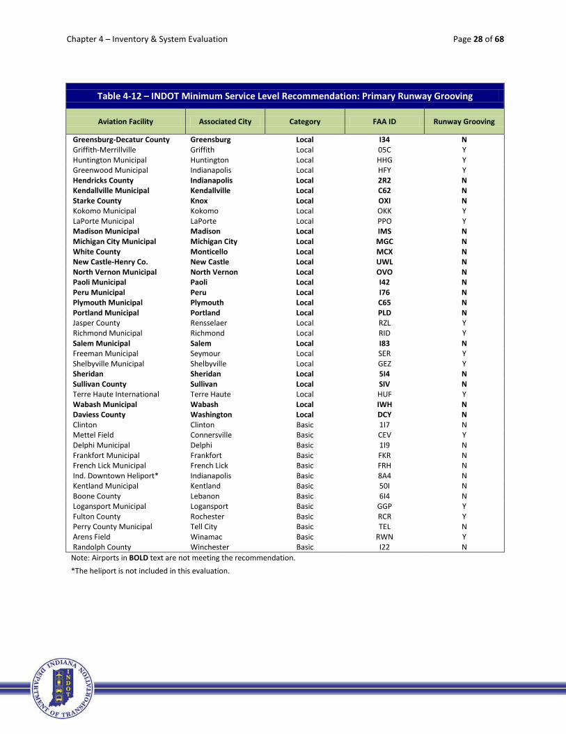
4.2.3 Primary Runway Grooving
As explained in Chapter 2, runway grooving allows aircraft to maintain a higher degree of contact with
the pavement surface when standing water is present to provide sufficient directional and braking control. Runway grooving is a recommendation for all airport classifications, except for those in the Basic
category.
Figure 4-10 indicates 66% of airports (23 airports) in the Local category are not meeting this recommended target, while all airports in the Primary and National classifications are. Table 4-12
includes a listing of all system airports. Those airports in bold text are not meeting this recommendation.

Chapter 4 – Inventory & System Evaluation Page 27 of 68
Table 4-12 – INDOT Minimum Service Level Recommendation: Primary Runway Grooving
Aviation Facility Associated City Category FAA ID Runway Grooving
Evansville Regional Evansville Primary EVV Y Ft. Wayne International Fort Wayne Primary FWA Y Indianapolis International Indianapolis Primary IND Y South Bend Regional South Bend Primary SBN Y Gary/Chicago Gary National GYY Y DeKalb County Auburn Regional GWB Y Monroe County Bloomington Regional BMG Y Columbus Municipal Columbus Regional BAK N Elkhart Municipal Elkhart Regional EKM Y Goshen Municipal Goshen Regional GSH Y Huntingburg Airport Huntingburg Regional HNB Y Eagle Creek Airpark Indianapolis Regional EYE Y Indianapolis Executive Indianapolis Regional TYQ Y Indianapolis Metropolitan Indianapolis Regional UMP N Indianapolis Regional Indianapolis Regional MQJ Y Clark County Jeffersonville Regional JVY Y Purdue University Lafayette Regional LAF Y Marion Municipal Marion Regional MZZ Y Delaware County Muncie Regional MIE Y Porter County Regional Valparaiso Regional VPZ Y Warsaw Municipal Warsaw Regional ASW Y Anderson Municipal Anderson Local AID Y Steuben Co.-Tri State Angola Local ANQ N Virgil I. Grissom Bedford Local BFR N Brazil-Clay County Brazil Local 0I2 N Crawfordsville Municipal Crawfordsville Local CFJ Y Smith Field Fort Wayne Local SMD N Putnam County Greencastle Local 4I7 N
13%
66%
0%10%20%30%40%50%60%70%80%90%
100%
Primary (4) National (1) Regional (16) Local (35)
Figure 4-10 - INDOT Minimum Service Level Recommendation: Primary Runway Grooving
% Airports Meeting Target
% Airports Not Meeting Target
Chapter 4 – Inventory & System Evaluation Page 28 of 68
Table 4-12 – INDOT Minimum Service Level Recommendation: Primary Runway Grooving
Aviation Facility Associated City Category FAA ID Runway Grooving
Greensburg-Decatur County Greensburg Local I34 N Griffith-Merrillville Griffith Local 05C Y Huntington Municipal Huntington Local HHG Y Greenwood Municipal Indianapolis Local HFY Y Hendricks County Indianapolis Local 2R2 N Kendallville Municipal Kendallville Local C62 N Starke County Knox Local OXI N Kokomo Municipal Kokomo Local OKK Y LaPorte Municipal LaPorte Local PPO Y Madison Municipal Madison Local IMS N Michigan City Municipal Michigan City Local MGC N White County Monticello Local MCX N New Castle-Henry Co. New Castle Local UWL N North Vernon Municipal North Vernon Local OVO N Paoli Municipal Paoli Local I42 N Peru Municipal Peru Local I76 N Plymouth Municipal Plymouth Local C65 N Portland Municipal Portland Local PLD N Jasper County Rensselaer Local RZL Y Richmond Municipal Richmond Local RID Y Salem Municipal Salem Local I83 N Freeman Municipal Seymour Local SER Y Shelbyville Municipal Shelbyville Local GEZ Y Sheridan Sheridan Local 5I4 N Sullivan County Sullivan Local SIV N Terre Haute International Terre Haute Local HUF Y Wabash Municipal Wabash Local IWH N Daviess County Washington Local DCY N Clinton Clinton Basic 1I7 N Mettel Field Connersville Basic CEV Y Delphi Municipal Delphi Basic 1I9 N Frankfort Municipal Frankfort Basic FKR N French Lick Municipal French Lick Basic FRH N Ind. Downtown Heliport* Indianapolis Basic 8A4 N Kentland Municipal Kentland Basic 50I N Boone County Lebanon Basic 6I4 N Logansport Municipal Logansport Basic GGP Y Fulton County Rochester Basic RCR Y Perry County Municipal Tell City Basic TEL N Arens Field Winamac Basic RWN Y Randolph County Winchester Basic I22 N Note: Airports in BOLD text are not meeting the recommendation. *The heliport is not included in this evaluation.

Chapter 4 – Inventory & System Evaluation Page 29 of 68
4.2.4 Primary Runway End Identifier Lights
Runway End Identifier Lights (REILs) are high intensity, synchronized flashing lights located on either side
of a runway threshold to provide positive visual identification of the end of a runway. This navigational aid is helpful for pilots in adverse conditions such as limited visibility, low cloud ceiling heights, or in urban environments where an airport may be surrounded by additional lighting.
Having REILs and/or approach lighting is a recommendation for all airport classifications, except Basic:
• Primary: Approach Lighting
• National: REILs if no Approach Lighting
• Regional: REILs if no Approach Lighting
• Local: REILs
The system as a whole is meeting this recommendation for the most part, with the exception of 17% of Local airports (six airports). Table 4-13 includes a listing of all system airports. Those airports in bold text
are not meeting this recommendation.
17%
0%10%20%30%40%50%60%70%80%90%
100%
Primary (4) National (1) Regional (16) Local (35)
Figure 4-11 - INDOT Minimum Service Level Recommendation: Primary Runway End Identifier Lights (REILs)
% Airports Meeting Target
% Airports Not Meeting Target

Chapter 4 – Inventory & System Evaluation Page 30 of 68
Table 4-13 – INDOT Minimum Service Level Recommendation: Primary Runway End Identifier Lights (REILs)
Aviation Facility Associated City Category FAA ID REILs Approach Lights
Evansville Regional Evansville Primary EVV Y MALSR Ft. Wayne International Fort Wayne Primary FWA Y ALSF2 Indianapolis International Indianapolis Primary IND N ALSF2 South Bend Regional South Bend Primary SBN N MALSR Gary/Chicago Gary National GYY Y MALSR DeKalb County Auburn Regional GWB Y MALSR Monroe County Bloomington Regional BMG N MALSR Columbus Municipal Columbus Regional BAK N MALSR Elkhart Municipal Elkhart Regional EKM N MALSR Goshen Municipal Goshen Regional GSH Y N Huntingburg Airport Huntingburg Regional HNB Y N Eagle Creek Airpark Indianapolis Regional EYE N MALS Indianapolis Executive Indianapolis Regional TYQ Y N Indianapolis Metropolitan Indianapolis Regional UMP Y N Indianapolis Regional Indianapolis Regional MQJ Y MALSR Clark County Jeffersonville Regional JVY Y MALSR Purdue University Lafayette Regional LAF Y MALSR Marion Municipal Marion Regional MZZ Y MALSR Delaware County Muncie Regional MIE Y MALSR Porter County Regional Valparaiso Regional VPZ Y MALSR Warsaw Municipal Warsaw Regional ASW Y N Anderson Municipal Anderson Local AID Y MALSF Steuben Co.-Tri State Angola Local ANQ Y N Virgil I. Grissom Bedford Local BFR Y N Brazil-Clay County Brazil Local 0I2 N N Crawfordsville Municipal Crawfordsville Local CFJ Y N Smith Field Fort Wayne Local SMD N N Putnam County Greencastle Local 4I7 Y N Greensburg-Decatur County Greensburg Local I34 N N Griffith-Merrillville Griffith Local 05C Y N Huntington Municipal Huntington Local HHG Y N Greenwood Municipal Indianapolis Local HFY Y N Hendricks County Indianapolis Local 2R2 Y N Kendallville Municipal Kendallville Local C62 Y N Starke County Knox Local OXI Y N Kokomo Municipal Kokomo Local OKK Y MALSR LaPorte Municipal LaPorte Local PPO Y N Madison Municipal Madison Local IMS N MALSF Michigan City Municipal Michigan City Local MGC Y N White County Monticello Local MCX Y N New Castle-Henry Co. New Castle Local UWL Y N North Vernon Municipal North Vernon Local OVO N N Paoli Municipal Paoli Local I42 N N Peru Municipal Peru Local I76 Y N Plymouth Municipal Plymouth Local C65 Y N Portland Municipal Portland Local PLD Y N Jasper County Rensselaer Local RZL N N Richmond Municipal Richmond Local RID Y LDIN Salem Municipal Salem Local I83 Y N

Chapter 4 – Inventory & System Evaluation Page 31 of 68
Table 4-13 – INDOT Minimum Service Level Recommendation: Primary Runway End Identifier Lights (REILs)
Aviation Facility Associated City Category FAA ID REILs Approach Lights
Freeman Municipal Seymour Local SER Y ODALS Shelbyville Municipal Shelbyville Local GEZ Y N Sheridan Sheridan Local 5I4 N N Sullivan County Sullivan Local SIV Y N Terre Haute International Terre Haute Local HUF Y MALSR Wabash Municipal Wabash Local IWH Y N Daviess County Washington Local DCY Y N Clinton Clinton Basic 1I7 N N Mettel Field Connersville Basic CEV Y MALSR Delphi Municipal Delphi Basic 1I9 N N Frankfort Municipal Frankfort Basic FKR Y N French Lick Municipal French Lick Basic FRH Y N Ind. Downtown Heliport Indianapolis Basic 8A4 PLASI ODALS Kentland Municipal Kentland Basic 50I Y N Boone County Lebanon Basic 6I4 N N Logansport Municipal Logansport Basic GGP Y N Fulton County Rochester Basic RCR Y N Perry County Municipal Tell City Basic TEL Y N Arens Field Winamac Basic RWN Y N Randolph County Winchester Basic I22 Y N
Note: Airports in BOLD text are not meeting the recommendation.
4.2.5 Primary Runway Visual Slope Indicators or Approach Lights
As described in Chapter 2, visual slope indicators (VSI) and approach lights (AL) help the pilot to see the
runway end. The following list indicates what is recommended for each airport classification:
• Primary: Approach Lighting
• National: Approach Lighting
• Regional: VSI (Approach Lighting Recommended)
• Local: VSI
• Basic: There is no minimum service level recommendation for Basic Airports
To meet this recommendation, an airport had to have either a VSI or AL on their primary runway
(depending on their airport classification). Approach lights can be in the form of MALSR: (medium intensity approach lighting system with runway alignment indicator lights) SSALR (short simplified
approach light system with runway alignment indicator lights) or ALSF: (approach lighting system with sequenced flashers). The VSI can be in the form of a Visual Approach Slope Indicators (VASIs) or Precision
Approach Path Indicators (PAPIs). Table 4-14 summarizes the types of VSI lighting systems and/or

Chapter 4 – Inventory & System Evaluation Page 32 of 68
approach lighting found at each system airport. Those airports in bold text are not meeting the recommendation. Only 9% of Local airports (three airports) are not meeting this target as a whole.
Table 4-14 – INDOT Minimum Service Level Recommendation: Primary Runway Visual Slope Indicators (VSI) or Approach Lights
Aviation Facility Associated City Category FAA ID VSI Approach Lights
Evansville Regional Evansville Primary EVV NO MALSR Ft. Wayne International Fort Wayne Primary FWA PAPI ALSF2 Indianapolis International Indianapolis Primary IND PAPI ALSF2 South Bend Regional South Bend Primary SBN PAPI MALSR Gary/Chicago Gary National GYY PAPI MALSR DeKalb County Auburn Regional GWB PAPI MALSR Monroe County Bloomington Regional BMG NO MALSR Columbus Municipal Columbus Regional BAK PAPI MALSR Elkhart Municipal Elkhart Regional EKM PAPI MALSR Goshen Municipal Goshen Regional GSH PAPI N* Huntingburg Airport Huntingburg Regional HNB VASI N* Eagle Creek Airpark Indianapolis Regional EYE PAPI MALS Indianapolis Executive Indianapolis Regional TYQ PAPI N* Indianapolis Metropolitan Indianapolis Regional UMP PAPI N* Indianapolis Regional Indianapolis Regional MQJ PAPI MALSR Clark County Jeffersonville Regional JVY VASI MALSR Purdue University Lafayette Regional LAF PAPI MALSR Marion Municipal Marion Regional MZZ VASI MALSR Delaware County Muncie Regional MIE VASI MALSR Porter County Regional Valparaiso Regional VPZ VASI MALSR Warsaw Municipal Warsaw Regional ASW PAPI N* Anderson Municipal Anderson Local AID VASI MALSF Steuben Co.-Tri State Angola Local ANQ N N Virgil I. Grissom Bedford Local BFR VASI N
9%
0%10%20%30%40%50%60%70%80%90%
100%
Primary (4) National (1) Regional (16) Local (35)
Figure 4-12 - INDOT Minimum Service Level Recommendation: Primary Runway Visual Slope Indicators (VSI) or Approach Lights
% Airports Meeting Target
% Airports Not Meeting Target

Chapter 4 – Inventory & System Evaluation Page 33 of 68
Table 4-14 – INDOT Minimum Service Level Recommendation: Primary Runway Visual Slope Indicators (VSI) or Approach Lights
Aviation Facility Associated City Category FAA ID VSI Approach Lights
Brazil-Clay County Brazil Local 0I2 N N Crawfordsville Municipal Crawfordsville Local CFJ PAPI N Smith Field Fort Wayne Local SMD PAPI N Putnam County Greencastle Local 4I7 PAPI N Greensburg-Decatur County Greensburg Local I34 VASI N Griffith-Merrillville Griffith Local 05C PAPI N Huntington Municipal Huntington Local HHG PAPI N Greenwood Municipal Indianapolis Local HFY PAPI N Hendricks County Indianapolis Local 2R2 PAPI N Kendallville Municipal Kendallville Local C62 PAPI N Starke County Knox Local OXI PAPI N Kokomo Municipal Kokomo Local OKK PAPI MALSR LaPorte Municipal LaPorte Local PPO PAPI N Madison Municipal Madison Local IMS PAPI MALSF Michigan City Municipal Michigan City Local MGC PAPI N White County Monticello Local MCX PAPI N New Castle-Henry Co. New Castle Local UWL PAPI N North Vernon Municipal North Vernon Local OVO PAPI N Paoli Municipal Paoli Local I42 PAPI N Peru Municipal Peru Local I76 PAPI N Plymouth Municipal Plymouth Local C65 VASI N Portland Municipal Portland Local PLD PAPI N Jasper County Rensselaer Local RZL N N Richmond Municipal Richmond Local RID PAPI LDIN Salem Municipal Salem Local I83 PAPI N Freeman Municipal Seymour Local SER PAPI ODALS Shelbyville Municipal Shelbyville Local GEZ VASI N Sheridan Sheridan Local 5I4 TRCV N Sullivan County Sullivan Local SIV VASI N Terre Haute International Terre Haute Local HUF PAPI MALSR Wabash Municipal Wabash Local IWH PAPI N Daviess County Washington Local DCY PAPI N Clinton Clinton Basic 1I7 N N Mettel Field Connersville Basic CEV PAPI MALSR Delphi Municipal Delphi Basic 1I9 N N Frankfort Municipal Frankfort Basic FKR PAPI N French Lick Municipal French Lick Basic FRH VASI N Ind. Downtown Heliport Indianapolis Basic 8A4 VASI ODALS Kentland Municipal Kentland Basic 50I PAPI N Boone County Lebanon Basic 6I4 N N Logansport Municipal Logansport Basic GGP PAPI N Fulton County Rochester Basic RCR PAPI N Perry County Municipal Tell City Basic TEL PAPI N Arens Field Winamac Basic RWN PAPI N Randolph County Winchester Basic I22 PAPI N
* Approach lighting is recommended for Regional airports, although VSI is all that is required. Note: Airports in BOLD text are not meeting the recommendation.

Chapter 4 – Inventory & System Evaluation Page 34 of 68
4.2.6 Perimeter Fencing
Fencing is a recommendation for airports in all five classifications. Access to an airport should be properly
controlled through the use of fencing and gates, to maintain security on the airfield, and to reduce wildlife activity on the facility. For the purposes of this inventory effort, a simple yes or no was reported for each airport regarding the existence of fencing.
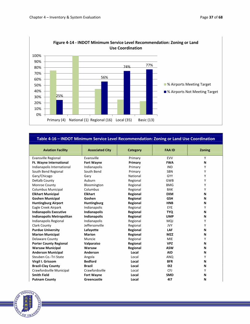
Figure 4-13 indicates 50% of Regional airports (eight airports), 77% of Local airports (27 airports), and 85% of Basic airports (11 airports) are not meeting this recommendation. Table 4-15 includes a listing of
all system airports. Those airports in bold text are not meeting this target.
50%
77% 85%
0%10%20%30%40%50%60%70%80%90%
100%
Primary (4) National (1) Regional (16) Local (35) Basic (13)
Figure 4-13 - INDOT Minimum Service Level Recommendation: Perimeter Fencing
% Airports Meeting Target
% Airports Not Meeting Target

Chapter 4 – Inventory & System Evaluation Page 35 of 68
Table 4-15 – INDOT Minimum Service Level Recommendation: Perimeter Fencing
Aviation Facility Associated City Category FAA ID Perimeter Fencing
Evansville Regional Evansville Primary EVV Y Ft. Wayne International Fort Wayne Primary FWA Y Indianapolis International Indianapolis Primary IND Y South Bend Regional South Bend Primary SBN Y Gary/Chicago Gary National GYY Y DeKalb County Auburn Regional GWB Y Monroe County Bloomington Regional BMG Y Columbus Municipal Columbus Regional BAK N Elkhart Municipal Elkhart Regional EKM Y Goshen Municipal Goshen Regional GSH Y Huntingburg Airport Huntingburg Regional HNB N Eagle Creek Airpark Indianapolis Regional EYE Y Indianapolis Executive Indianapolis Regional TYQ N Indianapolis Metropolitan Indianapolis Regional UMP Y Indianapolis Regional Indianapolis Regional MQJ N Clark County Jeffersonville Regional JVY N Purdue University Lafayette Regional LAF Y Marion Municipal Marion Regional MZZ N Delaware County Muncie Regional MIE N Porter County Regional Valparaiso Regional VPZ Y Warsaw Municipal Warsaw Regional ASW N Anderson Municipal Anderson Local AID Y Steuben Co.-Tri State Angola Local ANQ N Virgil I. Grissom Bedford Local BFR N Brazil-Clay County Brazil Local 0I2 N Crawfordsville Municipal Crawfordsville Local CFJ N Smith Field Fort Wayne Local SMD Y Putnam County Greencastle Local 4I7 N Greensburg-Decatur County Greensburg Local I34 N Griffith-Merrillville Griffith Local 05C N Huntington Municipal Huntington Local HHG N Greenwood Municipal Indianapolis Local HFY Y Hendricks County Indianapolis Local 2R2 N Kendallville Municipal Kendallville Local C62 N Starke County Knox Local OXI N Kokomo Municipal Kokomo Local OKK Y LaPorte Municipal LaPorte Local PPO N Madison Municipal Madison Local IMS N Michigan City Municipal Michigan City Local MGC N White County Monticello Local MCX N New Castle-Henry Co. New Castle Local UWL N North Vernon Municipal North Vernon Local OVO Y Paoli Municipal Paoli Local I42 N Peru Municipal Peru Local I76 N Plymouth Municipal Plymouth Local C65 N Portland Municipal Portland Local PLD N Jasper County Rensselaer Local RZL N Richmond Municipal Richmond Local RID N Salem Municipal Salem Local I83 Y
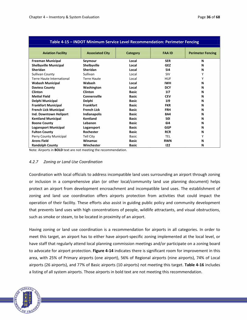
Chapter 4 – Inventory & System Evaluation Page 36 of 68
Table 4-15 – INDOT Minimum Service Level Recommendation: Perimeter Fencing
Aviation Facility Associated City Category FAA ID Perimeter Fencing
Freeman Municipal Seymour Local SER N Shelbyville Municipal Shelbyville Local GEZ N Sheridan Sheridan Local 5I4 N Sullivan County Sullivan Local SIV Y Terre Haute International Terre Haute Local HUF Y Wabash Municipal Wabash Local IWH N Daviess County Washington Local DCY N Clinton Clinton Basic 1I7 N Mettel Field Connersville Basic CEV N Delphi Municipal Delphi Basic 1I9 N Frankfort Municipal Frankfort Basic FKR N French Lick Municipal French Lick Basic FRH N Ind. Downtown Heliport Indianapolis Basic 8A4 N Kentland Municipal Kentland Basic 50I N Boone County Lebanon Basic 6I4 N Logansport Municipal Logansport Basic GGP N Fulton County Rochester Basic RCR N Perry County Municipal Tell City Basic TEL Y Arens Field Winamac Basic RWN N Randolph County Winchester Basic I22 N
Note: Airports in BOLD text are not meeting the recommendation.
4.2.7 Zoning or Land Use Coordination
Coordination with local officials to address incompatible land uses surrounding an airport through zoning
or inclusion in a comprehensive plan (or other local/community land use planning document) helps protect an airport from development encroachment and incompatible land uses. The establishment of
zoning and land use coordination offers airports protection from activities that could impact the operation of their facility. These efforts also assist in guiding public policy and community development
that prevents land uses with high concentrations of people, wildlife attractants, and visual obstructions, such as smoke or steam, to be located in proximity of an airport.
Having zoning or land use coordination is a recommendation for airports in all categories. In order to
meet this target, an airport has to either have airport-specific zoning implemented at the local level, or have staff that regularly attend local planning commission meetings and/or participate on a zoning board
to advocate for airport protection. Figure 4-14 indicates there is significant room for improvement in this area, with 25% of Primary airports (one airport), 56% of Regional airports (nine airports), 74% of Local
airports (26 airports), and 77% of Basic airports (10 airports) not meeting this target. Table 4-16 includes a listing of all system airports. Those airports in bold text are not meeting this recommendation.
Chapter 4 – Inventory & System Evaluation Page 37 of 68
Table 4-16 – INDOT Minimum Service Level Recommendation: Zoning or Land Use Coordination
Aviation Facility Associated City Category FAA ID Zoning
Evansville Regional Evansville Primary EVV Y Ft. Wayne International Fort Wayne Primary FWA N Indianapolis International Indianapolis Primary IND Y South Bend Regional South Bend Primary SBN Y Gary/Chicago Gary National GYY Y DeKalb County Auburn Regional GWB Y Monroe County Bloomington Regional BMG Y Columbus Municipal Columbus Regional BAK Y Elkhart Municipal Elkhart Regional EKM N Goshen Municipal Goshen Regional GSH N Huntingburg Airport Huntingburg Regional HNB N Eagle Creek Airpark Indianapolis Regional EYE Y Indianapolis Executive Indianapolis Regional TYQ N Indianapolis Metropolitan Indianapolis Regional UMP N Indianapolis Regional Indianapolis Regional MQJ Y Clark County Jeffersonville Regional JVY Y Purdue University Lafayette Regional LAF N Marion Municipal Marion Regional MZZ N Delaware County Muncie Regional MIE Y Porter County Regional Valparaiso Regional VPZ N Warsaw Municipal Warsaw Regional ASW N Anderson Municipal Anderson Local AID N Steuben Co.-Tri State Angola Local ANQ Y Virgil I. Grissom Bedford Local BFR N Brazil-Clay County Brazil Local 0I2 N Crawfordsville Municipal Crawfordsville Local CFJ Y Smith Field Fort Wayne Local SMD N Putnam County Greencastle Local 4I7 N
25%
56%
74% 77%
0%10%20%30%40%50%60%70%80%90%
100%
Primary (4) National (1) Regional (16) Local (35) Basic (13)
Figure 4-14 - INDOT Minimum Service Level Recommendation: Zoning or Land Use Coordination
% Airports Meeting Target
% Airports Not Meeting Target

Chapter 4 – Inventory & System Evaluation Page 38 of 68
Table 4-16 – INDOT Minimum Service Level Recommendation: Zoning or Land Use Coordination
Aviation Facility Associated City Category FAA ID Zoning
Greensburg-Decatur County Greensburg Local I34 N Griffith-Merrillville Griffith Local 05C N Huntington Municipal Huntington Local HHG N Greenwood Municipal Indianapolis Local HFY N Hendricks County Indianapolis Local 2R2 Y Kendallville Municipal Kendallville Local C62 N Starke County Knox Local OXI N Kokomo Municipal Kokomo Local OKK Y LaPorte Municipal LaPorte Local PPO Y Madison Municipal Madison Local IMS N Michigan City Municipal Michigan City Local MGC Y White County Monticello Local MCX N New Castle-Henry Co. New Castle Local UWL N North Vernon Municipal North Vernon Local OVO Y Paoli Municipal Paoli Local I42 N Peru Municipal Peru Local I76 N Plymouth Municipal Plymouth Local C65 Y Portland Municipal Portland Local PLD N Jasper County Rensselaer Local RZL N Richmond Municipal Richmond Local RID N Salem Municipal Salem Local I83 N Freeman Municipal Seymour Local SER N Shelbyville Municipal Shelbyville Local GEZ N Sheridan Sheridan Local 5I4 N Sullivan County Sullivan Local SIV N Terre Haute International Terre Haute Local HUF Y Wabash Municipal Wabash Local IWH N Daviess County Washington Local DCY N Clinton Clinton Basic 1I7 N Mettel Field Connersville Basic CEV N Delphi Municipal Delphi Basic 1I9 N Frankfort Municipal Frankfort Basic FKR Y French Lick Municipal French Lick Basic FRH N Ind. Downtown Heliport Indianapolis Basic 8A4 Y Kentland Municipal Kentland Basic 50I N Boone County Lebanon Basic 6I4 N Logansport Municipal Logansport Basic GGP N Fulton County Rochester Basic RCR Y Perry County Municipal Tell City Basic TEL N Arens Field Winamac Basic RWN N Randolph County Winchester Basic I22 N
Note: Airports in BOLD text are not meeting the recommendation.
Chapter 4 – Inventory & System Evaluation Page 39 of 68
4.3 INDOT Minimum Vertically Guided Instrument Approach Procedure (IAP)
Recommendations
This section of the system inventory includes the INDOT Minimum Vertically Guided IAP Recommendations. These have been identified to support the continued development of approaches
that provide increased access to the system airports. Table 4-17 includes the recommended target for visibility and ceiling minimum for vertically guided IAPs for each airport classification. Each of these are
inventoried and evaluated in the following sections. FAA Advisory Circular AC 150/5300-13, Airport Design, Change 18, was the current FAA guidance at the time of the evaluation, and the FAA
requirements associated with each IAP minimum were derived from this source.
Table 4-17 – INDOT Minimum Vertically Guided IAP Recommendations
INDOT MINIMUM VERTICALLY GUIDED IAP RECOMMENDATIONS3 PRIMARY NATIONAL REGIONAL LOCAL BASIC
Visibility Minimums (One End Minimum) 1/2 mile < 3/4 mile < 1 mile 1 mile > 1 mile
Ceiling Minimums1 (One End Minimum) 200' 250' 300' 350' 400'
Obstruction Survey (VG or ANA)4 VG VG or ANA VG or ANA VG or ANA VG or ANA
Basic Requirements by AC FAA 150/5300-132
Approved ALP on File ALP w/ LPV or ILS
ALP w/ LPV or ILS
ALP w/ LPV or ILS ALP w/ LPV ALP w/ LPV
Minimum Runway Length 4,200 ft. 4,200 ft. 3,200 ft.
3,200 ft. 3,200 ft. (Paved) (Paved) (Paved)
Runway Markings & Signage
Precision Precision Nonprecision
(precision recommended)
Nonprecision Nonprecision
Hold Position Setback 250'
Hold Position
Setback 250'
Hold Position Setback 250'
(200' <=A/B-II)
Hold Position Setback 250'
(200' <=A/B-II; 125' <=A/B-I Sm)
Hold Position Setback 200'
(125' <=A/B-I Sm)
Full Parallel Taxiway or Comparable Required Required Required Recommended Recommended
Runway Edge Lights HIRL/MIRL HIRL/MIRL HIRL/MIRL MIRL/LIRL MIRL/LIRL
Approach Lights (One End Minimum) MALSR, SSALR, ALSF
MALSR, SSALR, ALSF Recommended Recommended Recommended
POFZ Required Required Recommended Recommended Recommended 1 For LPV with ILS, lowest ceiling minimums are 200'.
2 The requirements under this heading are found within FAA AC 150/5300-13, Airport Design, Change 18. Meeting basic required elements of class does not guarantee minimums. A detailed airspace analysis will need to be performed to determine best potential minimums.
3 Represents minimum goal for Primary runway. Attaining greater may be justified. 4 Vertically Guided or Area Navigation Approach Survey
ACRONYMS AND GLOSSARY
IAP: Instrument Approach Procedure

Chapter 4 – Inventory & System Evaluation Page 40 of 68
Aircraft Approach Category
Speed (knots)
Airplane Design Group Wingspan (feet) or Tail Height (feet)
A Less than 91 I Wingspan less than 49 or Tail Height up to but not including 20
B 91 to less
than 121 II
Wingspan 49 up to but not including 79 or Tail Height from 20
up to but not including 30
C 121 to less
than 141 III
Wingspan 79 up to but not including 118 or Tail Height from 30 up to but not including 45
D 141 to less
than 166 IV
Wingspan 118 up to but not including 171 or Tail Height from 45 up to but not including 60
E 166 or more V Wingspan 171 up to but not including 214 or Tail Height from
60 up to but not including 66
VI Wingspan 214 up to but not including 262 or Tail Height from
66 up to but not including 80
Source: FAA Advisory Circular 150/5300-13, Airport Design.
LPV: Localizer performance with vertical guidance VG: Vertical guidance ILS: Instrument Landing System ANA: Area Navigation Approach ALP: FAA approved airport layout plan POFZ: Precision object free area - rectangular safety area at the runway threshold, centered on the extended runway centerline and
is 200 feet long by 800 feet wide. Runway Edge Lights:
HIRL: High intensity runway lighting LIRL: Low intensity runway lighting
Approach Lights (AL): MALSR: Medium intensity approach lighting system with runway alignment indicator lights SSALR: Short simplified approach light system with runway alignment indicator lights ALSF: Approach lighting system with sequenced flashers
Runway Markings and Signage: A runway is painted with various markings that coincide with the type of approach it has. This recommended target, as part of the FAA AC 150/5300-13 criteria, has two components for each airport classification. The first component is the type of markings on an airport’s runway: precision or non-precision. The second component is the hold position setback, which is the line on a taxiway where a pilot is to stop when not cleared to proceed onto the runway. The appropriate setback distance is determined by the design aircraft (the most demanding aircraft making at least 500 annual operations on a runway [see following page]) and the type of approach to the runway.
Airport Reference Code (e.g. A/B-II): The FAA has developed a system to relate airport planning and design criteria to the operational and physical characteristics of the aircraft intended to use the airport. This system is known as the Airport Reference Code (ARC), and is detailed in FAA Advisory Circular 150/5300-13, Airport Design. A combination of two codes is used to develop the ARC. The first code, Aircraft Approach Category, relates to the approach speed (landing speed) of an aircraft. The second code, Airplane Design Group, pertains to the design group determined by the wingspan or tail height of an aircraft. The ARC is based upon the aircraft or combination of aircraft with the highest approach speed code and greatest wingspan that use, or are expected to make substantial use, of the airport. Per FAA Order 5090.3C, Field Formulation of the National Plan of Integrated Airport Systems, substantial use means 500 or more annual itinerant operations. An operation is a takeoff or landing by an aircraft.
Chapter 4 – Inventory & System Evaluation Page 41 of 68
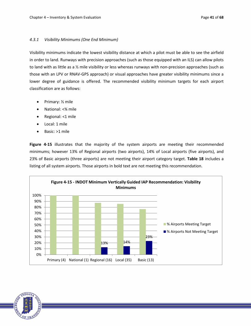
4.3.1 Visibility Minimums (One End Minimum)
Visibility minimums indicate the lowest visibility distance at which a pilot must be able to see the airfield
in order to land. Runways with precision approaches (such as those equipped with an ILS) can allow pilots to land with as little as a ½ mile visibility or less whereas runways with non-precision approaches (such as those with an LPV or RNAV-GPS approach) or visual approaches have greater visibility minimums since a
lower degree of guidance is offered. The recommended visibility minimum targets for each airport classification are as follows:
• Primary: ½ mile
• National: <¾ mile
• Regional: <1 mile
• Local: 1 mile
• Basic: >1 mile
Figure 4-15 illustrates that the majority of the system airports are meeting their recommended minimums; however 13% of Regional airports (two airports), 14% of Local airports (five airports), and
23% of Basic airports (three airports) are not meeting their airport category target. Table 18 includes a listing of all system airports. Those airports in bold text are not meeting this recommendation.
13% 14% 23%
0%10%20%30%40%50%60%70%80%90%
100%
Primary (4) National (1) Regional (16) Local (35) Basic (13)
Figure 4-15 - INDOT Minimum Vertically Guided IAP Recommendation: Visibility Minimums
% Airports Meeting Target
% Airports Not Meeting Target

Chapter 4 – Inventory & System Evaluation Page 42 of 68
Table 4-18 – INDOT Minimum Vertically Guided IAP Recommendation: Visibility Minimums
Aviation Facility Associated City Category FAA ID Best IAP Visibility
Evansville Regional Evansville Primary EVV ½ Ft. Wayne International Fort Wayne Primary FWA CAT II Indianapolis International Indianapolis Primary IND CAT III South Bend Regional South Bend Primary SBN ½ Gary/Chicago Gary National GYY ½ DeKalb County Auburn Regional GWB ½ Monroe County Bloomington Regional BMG ½ Columbus Municipal Columbus Regional BAK ½ Elkhart Municipal Elkhart Regional EKM ½ Goshen Municipal Goshen Regional GSH ¾ Huntingburg Airport Huntingburg Regional HNB 1 Eagle Creek Airpark Indianapolis Regional EYE ¾ Indianapolis Executive Indianapolis Regional TYQ ¾ Indianapolis Metropolitan Indianapolis Regional UMP 1 Indianapolis Regional Indianapolis Regional MQJ ½ Clark County Jeffersonville Regional JVY ½ Purdue University Lafayette Regional LAF ½ Marion Municipal Marion Regional MZZ ½ Delaware County Muncie Regional MIE ½ Porter County Regional Valparaiso Regional VPZ ½ Warsaw Municipal Warsaw Regional ASW ¾ Anderson Municipal Anderson Local AID 1 Steuben Co.-Tri State Angola Local ANQ 1½ Virgil I. Grissom Bedford Local BFR 1 Brazil-Clay County Brazil Local 0I2 1 Crawfordsville Municipal Crawfordsville Local CFJ 1 Smith Field Fort Wayne Local SMD 1 Putnam County Greencastle Local 4I7 1¼ Greensburg-Decatur County Greensburg Local I34 1 Griffith-Merrillville Griffith Local 05C 1 Huntington Municipal Huntington Local HHG 1 Greenwood Municipal Indianapolis Local HFY 1 Hendricks County Indianapolis Local 2R2 1 Kendallville Municipal Kendallville Local C62 1 Starke County Knox Local OXI 1 Kokomo Municipal Kokomo Local OKK 1 LaPorte Municipal LaPorte Local PPO 1 Madison Municipal Madison Local IMS 1 ¼ Michigan City Municipal Michigan City Local MGC 1 White County Monticello Local MCX 1 New Castle-Henry Co. New Castle Local UWL 1 North Vernon Municipal North Vernon Local OVO 1 Paoli Municipal Paoli Local I42 NA Peru Municipal Peru Local I76 1 Plymouth Municipal Plymouth Local C65 1 Portland Municipal Portland Local PLD 1 Jasper County Rensselaer Local RZL 1 Richmond Municipal Richmond Local RID ¾ Salem Municipal Salem Local I83 NA
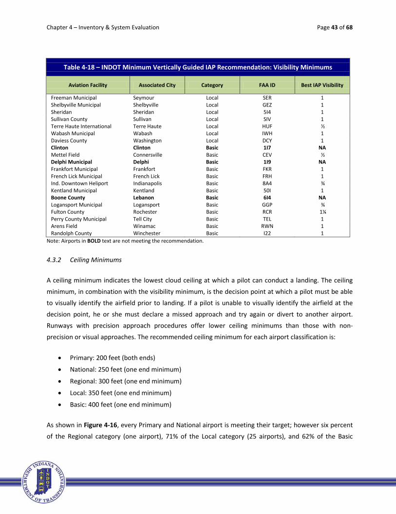
Chapter 4 – Inventory & System Evaluation Page 43 of 68
Table 4-18 – INDOT Minimum Vertically Guided IAP Recommendation: Visibility Minimums
Aviation Facility Associated City Category FAA ID Best IAP Visibility
Freeman Municipal Seymour Local SER 1 Shelbyville Municipal Shelbyville Local GEZ 1 Sheridan Sheridan Local 5I4 1 Sullivan County Sullivan Local SIV 1 Terre Haute International Terre Haute Local HUF ½ Wabash Municipal Wabash Local IWH 1 Daviess County Washington Local DCY 1 Clinton Clinton Basic 1I7 NA Mettel Field Connersville Basic CEV ½ Delphi Municipal Delphi Basic 1I9 NA Frankfort Municipal Frankfort Basic FKR 1 French Lick Municipal French Lick Basic FRH 1 Ind. Downtown Heliport Indianapolis Basic 8A4 ¾ Kentland Municipal Kentland Basic 50I 1 Boone County Lebanon Basic 6I4 NA Logansport Municipal Logansport Basic GGP ¾ Fulton County Rochester Basic RCR 1¼ Perry County Municipal Tell City Basic TEL 1 Arens Field Winamac Basic RWN 1 Randolph County Winchester Basic I22 1
Note: Airports in BOLD text are not meeting the recommendation.
4.3.2 Ceiling Minimums
A ceiling minimum indicates the lowest cloud ceiling at which a pilot can conduct a landing. The ceiling
minimum, in combination with the visibility minimum, is the decision point at which a pilot must be able to visually identify the airfield prior to landing. If a pilot is unable to visually identify the airfield at the
decision point, he or she must declare a missed approach and try again or divert to another airport. Runways with precision approach procedures offer lower ceiling minimums than those with non-
precision or visual approaches. The recommended ceiling minimum for each airport classification is:
• Primary: 200 feet (both ends)
• National: 250 feet (one end minimum)
• Regional: 300 feet (one end minimum)
• Local: 350 feet (one end minimum)
• Basic: 400 feet (one end minimum)
As shown in Figure 4-16, every Primary and National airport is meeting their target; however six percent
of the Regional category (one airport), 71% of the Local category (25 airports), and 62% of the Basic

Chapter 4 – Inventory & System Evaluation Page 44 of 68
category (eight airports) are not meeting their recommendation. Table 4-19 includes a listing of all system airports. Those airports in bold text are not meeting the IAP recommendation.
Table 4-19 – INDOT Minimum Vertically Guided IAP Recommendation: Ceiling Minimums
Aviation Facility Associated City Category FAA ID Meets Ceiling Minimum
Evansville Regional Evansville Primary EVV Y Ft. Wayne International Fort Wayne Primary FWA Y Indianapolis International Indianapolis Primary IND Y South Bend Regional South Bend Primary SBN Y Gary/Chicago Gary National GYY Y DeKalb County Auburn Regional GWB Y Monroe County Bloomington Regional BMG Y Columbus Municipal Columbus Regional BAK Y Elkhart Municipal Elkhart Regional EKM Y Goshen Municipal Goshen Regional GSH Y Huntingburg Airport Huntingburg Regional HNB Y Eagle Creek Airpark Indianapolis Regional EYE Y Indianapolis Executive Indianapolis Regional TYQ Y Indianapolis Metropolitan Indianapolis Regional UMP N Indianapolis Regional Indianapolis Regional MQJ Y Clark County Jeffersonville Regional JVY Y Purdue University Lafayette Regional LAF Y Marion Municipal Marion Regional MZZ Y Delaware County Muncie Regional MIE Y Porter County Regional Valparaiso Regional VPZ Y Warsaw Municipal Warsaw Regional ASW Y Anderson Municipal Anderson Local AID Y Steuben Co.-Tri State Angola Local ANQ N Virgil I. Grissom Bedford Local BFR N
6%
71% 62%
0%10%20%30%40%50%60%70%80%90%
100%
Primary (4) National (1) Regional (16) Local (35) Basic (13)
Figure 4-16 - INDOT Minimum Vertically Guided IAP Recommendation: Ceiling Minimums
% Airports Meeting Target
% Airports Not Meeting Target
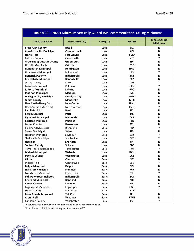
Chapter 4 – Inventory & System Evaluation Page 45 of 68
Table 4-19 – INDOT Minimum Vertically Guided IAP Recommendation: Ceiling Minimums
Aviation Facility Associated City Category FAA ID Meets Ceiling Minimum
Brazil-Clay County Brazil Local 0I2 N Crawfordsville Municipal Crawfordsville Local CFJ N Smith Field Fort Wayne Local SMD N Putnam County Greencastle Local 4I7 Y Greensburg-Decatur County Greensburg Local I34 N Griffith-Merrillville Griffith Local 05C N Huntington Municipal Huntington Local HHG N Greenwood Municipal Indianapolis Local HFY Y Hendricks County Indianapolis Local 2R2 N Kendallville Municipal Kendallville Local C62 N Starke County Knox Local OXI Y Kokomo Municipal Kokomo Local OKK Y LaPorte Municipal LaPorte Local PPO N Madison Municipal Madison Local IMS N Michigan City Municipal Michigan City Local MGC N White County Monticello Local MCX N New Castle-Henry Co. New Castle Local UWL N North Vernon Municipal North Vernon Local OVO Y Paoli Municipal Paoli Local I42 N Peru Municipal Peru Local I76 N Plymouth Municipal Plymouth Local C65 N Portland Municipal Portland Local PLD N Jasper County Rensselaer Local RZL N Richmond Municipal Richmond Local RID Y Salem Municipal Salem Local I83 N Freeman Municipal Seymour Local SER Y Shelbyville Municipal Shelbyville Local GEZ Y Sheridan Sheridan Local 5I4 N Sullivan County Sullivan Local SIV N Terre Haute International Terre Haute Local HUF Y Wabash Municipal Wabash Local IWH N Daviess County Washington Local DCY N Clinton Clinton Basic 1I7 N Mettel Field Connersville Basic CEV Y Delphi Municipal Delphi Basic 1I9 N Frankfort Municipal Frankfort Basic FKR N French Lick Municipal French Lick Basic FRH Y Ind. Downtown Heliport Indianapolis Basic 8A4 N Kentland Municipal Kentland Basic 50I N Boone County Lebanon Basic 6I4 N Logansport Municipal Logansport Basic GGP Y Fulton County Rochester Basic RCR Y Perry County Municipal Tell City Basic TEL N Arens Field Winamac Basic RWN N Randolph County Winchester Basic I22 Y Note: Airports in BOLD text are not meeting the recommendation. * For LPV with ILS, lowest ceiling minimums are 200'
Chapter 4 – Inventory & System Evaluation Page 46 of 68
4.3.3 Obstruction Survey
An obstruction survey identifies obstructions that penetrate an airport’s runway approach(es) that must
be avoided by aircraft when on approach to land or take-off. Penetrating objects should be removed or lowered below the approach and departure surface slope so that the approach and departure area can remain free of obstructions. There are generally two types of obstruction surveys to meet FAA standards
for developing instrument approaches: those for runways with vertical guidance (VG) and those for runways without vertical guidance (NVG). There are a few kinds of VG surveys, but for simplicity in this
chapter they are broken down into VG or ANA (Area Navigation Approach for Localizer Performance with Vertical guidance [LPV]). The recommended obstruction survey is the one needed to meet FAA guidelines
for the IAP visibility and ceiling minimums recommended for each airport classification:
• Primary: VG
• National: VG or ANA
• Regional: VG or ANA
• Local: VG or ANA
• Basic: VG or ANA
Figure 4-17 illustrates 50 % of Regional airports (eight airports), 83% of Local airports (29 airports), and
69% of Basic airports (nine airports) are not meeting this target. Table 4-20 includes a listing of all system airports. Those airports in bold text are not meeting this recommendation.
50%
83%
69%
0%10%20%30%40%50%60%70%80%90%
100%
Primary (4) National (1) Regional (16) Local (35) Basic (13)
Figure 4-17 - INDOT Minimum Vertically Guided IAP Recommendation: Obstruction Survey
% Airports Meeting Target
% Airports Not Meeting Target

Chapter 4 – Inventory & System Evaluation Page 47 of 68
Table 4-20 – INDOT Minimum Vertically Guided IAP Recommendation: Obstruction Survey
Aviation Facility Associated City Category FAA ID Obstruction Survey
Evansville Regional Evansville Primary EVV Y Ft. Wayne International Fort Wayne Primary FWA Y Indianapolis International Indianapolis Primary IND Y South Bend Regional South Bend Primary SBN Y Gary/Chicago Gary National GYY Y DeKalb County Auburn Regional GWB N Monroe County Bloomington Regional BMG N Columbus Municipal Columbus Regional BAK Y Elkhart Municipal Elkhart Regional EKM Y Goshen Municipal Goshen Regional GSH Y Huntingburg Airport Huntingburg Regional HNB N Eagle Creek Airpark Indianapolis Regional EYE Y Indianapolis Executive Indianapolis Regional TYQ N Indianapolis Metropolitan Indianapolis Regional UMP Y Indianapolis Regional Indianapolis Regional MQJ Y Clark County Jeffersonville Regional JVY N Purdue University Lafayette Regional LAF N Marion Municipal Marion Regional MZZ Y Delaware County Muncie Regional MIE N Porter County Regional Valparaiso Regional VPZ Y Warsaw Municipal Warsaw Regional ASW N Anderson Municipal Anderson Local AID N Steuben Co.-Tri State Angola Local ANQ Y Virgil I. Grissom Bedford Local BFR N Brazil-Clay County Brazil Local 0I2 N Crawfordsville Municipal Crawfordsville Local CFJ Y Smith Field Fort Wayne Local SMD N Putnam County Greencastle Local 4I7 N Greensburg-Decatur County Greensburg Local I34 N Griffith-Merrillville Griffith Local 05C N Huntington Municipal Huntington Local HHG N Greenwood Municipal Indianapolis Local HFY N Hendricks County Indianapolis Local 2R2 Y Kendallville Municipal Kendallville Local C62 Y Starke County Knox Local OXI N Kokomo Municipal Kokomo Local OKK N LaPorte Municipal LaPorte Local PPO Y Madison Municipal Madison Local IMS N Michigan City Municipal Michigan City Local MGC N White County Monticello Local MCX N New Castle-Henry Co. New Castle Local UWL N North Vernon Municipal North Vernon Local OVO N Paoli Municipal Paoli Local I42 N Peru Municipal Peru Local I76 N Plymouth Municipal Plymouth Local C65 N Portland Municipal Portland Local PLD N Jasper County Rensselaer Local RZL N Richmond Municipal Richmond Local RID Y Salem Municipal Salem Local I83 N

Chapter 4 – Inventory & System Evaluation Page 48 of 68
Table 4-20 – INDOT Minimum Vertically Guided IAP Recommendation: Obstruction Survey
Aviation Facility Associated City Category FAA ID Obstruction Survey
Freeman Municipal Seymour Local SER N Shelbyville Municipal Shelbyville Local GEZ N Sheridan Sheridan Local 5I4 N Sullivan County Sullivan Local SIV N Terre Haute International Terre Haute Local HUF N Wabash Municipal Wabash Local IWH N Daviess County Washington Local DCY N Clinton Clinton Basic 1I7 N Mettel Field Connersville Basic CEV N Delphi Municipal Delphi Basic 1I9 N Frankfort Municipal Frankfort Basic FKR Y French Lick Municipal French Lick Basic FRH N Ind. Downtown Heliport Indianapolis Basic 8A4 N Kentland Municipal Kentland Basic 50I N Boone County Lebanon Basic 6I4 N Logansport Municipal Logansport Basic GGP Y Fulton County Rochester Basic RCR N Perry County Municipal Tell City Basic TEL Y Arens Field Winamac Basic RWN N Randolph County Winchester Basic I22 Y
Note: Airports in BOLD text are not meeting the recommendation.

Chapter 4 – Inventory & System Evaluation Page 49 of 68
4.3.4 Basic Requirements by AC FAA 150/5300-13, Airport Design, Change 18
The following sub-sections include an inventory and evaluation of some of the other basic requirements
that are included in FAA AC 150/5300-13 for new instrument approach procedures. Even though having a vertically guided approach is a recommendation of INDOT, the elements associated with the criteria are actually requirements to meet FAA design standards for the respective approach recommended. (Note:
FAA Advisory Circular AC 150/5300-13, Airport Design, Change 18, was the current FAA guidance at the time of the evaluation.) Consequently, meeting these criteria are not optional based upon FAA needs, if
an airport wants to develop an approach or reduce existing approach visibility and ceiling minimums to meet the recommendation.
4.3.4.i Approved Airport Layout Plan (ALP) on File with Appropriate Approach
To meet this requirement, an airport has to have an approved ALP on file with the FAA that shows an approach appropriate to the design criteria associated with the specific airport,
depending on the airport’s classification.
The required approach type for each airport classification varies:
• Primary: LPV and ILS approaches
• National: LPV or ILS approaches
• Regional: LPV or ILS approaches
• Local: LPV approach
• Basic: LPV approach
Figure 4-18 illustrates that six percent of Regional airports (one airport), 71% of Local airports (25
airports), and 62% of Basic airports (eight airports) are not meeting this requirement. A significant number of system airports could target this as a goal to better enhance and serve the
system. Table 4-21 includes a listing of all system airports. Those airports in bold text are not meeting this requirement for their IAP recommendation.
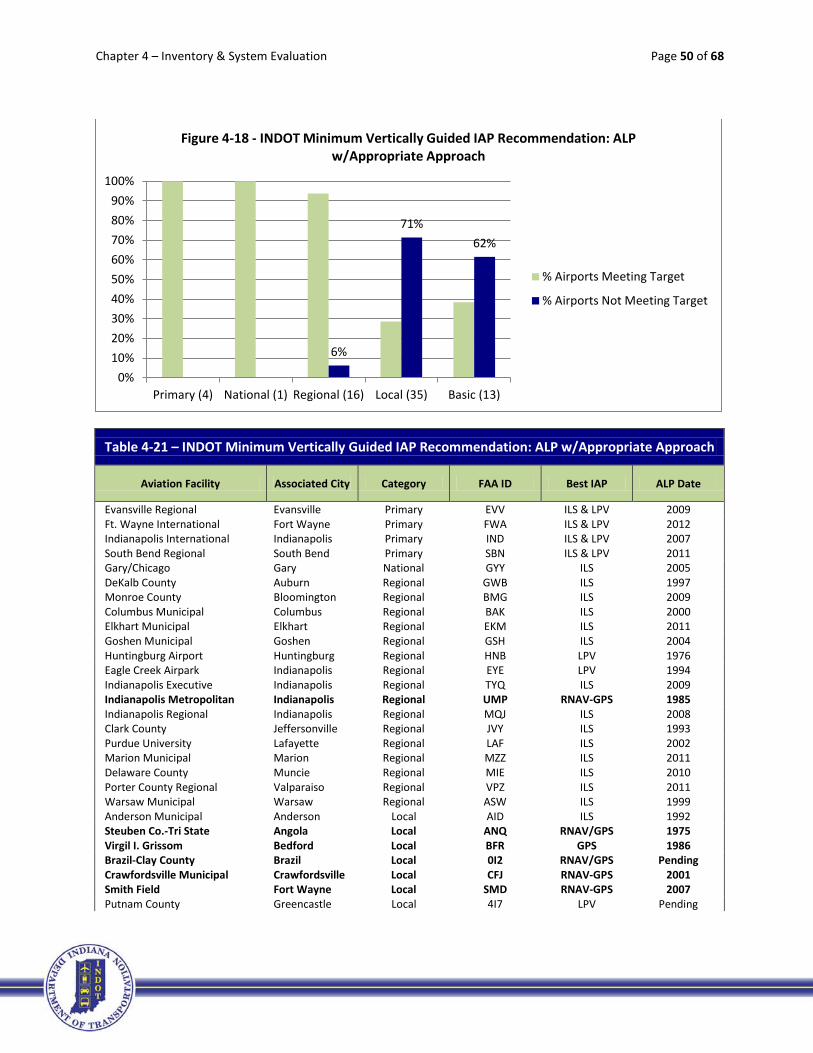
Chapter 4 – Inventory & System Evaluation Page 50 of 68
Table 4-21 – INDOT Minimum Vertically Guided IAP Recommendation: ALP w/Appropriate Approach
Aviation Facility Associated City Category FAA ID Best IAP ALP Date
Evansville Regional Evansville Primary EVV ILS & LPV 2009 Ft. Wayne International Fort Wayne Primary FWA ILS & LPV 2012 Indianapolis International Indianapolis Primary IND ILS & LPV 2007 South Bend Regional South Bend Primary SBN ILS & LPV 2011 Gary/Chicago Gary National GYY ILS 2005 DeKalb County Auburn Regional GWB ILS 1997 Monroe County Bloomington Regional BMG ILS 2009 Columbus Municipal Columbus Regional BAK ILS 2000 Elkhart Municipal Elkhart Regional EKM ILS 2011 Goshen Municipal Goshen Regional GSH ILS 2004 Huntingburg Airport Huntingburg Regional HNB LPV 1976 Eagle Creek Airpark Indianapolis Regional EYE LPV 1994 Indianapolis Executive Indianapolis Regional TYQ ILS 2009 Indianapolis Metropolitan Indianapolis Regional UMP RNAV-GPS 1985 Indianapolis Regional Indianapolis Regional MQJ ILS 2008 Clark County Jeffersonville Regional JVY ILS 1993 Purdue University Lafayette Regional LAF ILS 2002 Marion Municipal Marion Regional MZZ ILS 2011 Delaware County Muncie Regional MIE ILS 2010 Porter County Regional Valparaiso Regional VPZ ILS 2011 Warsaw Municipal Warsaw Regional ASW ILS 1999 Anderson Municipal Anderson Local AID ILS 1992 Steuben Co.-Tri State Angola Local ANQ RNAV/GPS 1975 Virgil I. Grissom Bedford Local BFR GPS 1986 Brazil-Clay County Brazil Local 0I2 RNAV/GPS Pending Crawfordsville Municipal Crawfordsville Local CFJ RNAV-GPS 2001 Smith Field Fort Wayne Local SMD RNAV-GPS 2007 Putnam County Greencastle Local 4I7 LPV Pending
6%
71% 62%
0%10%20%30%40%50%60%70%80%90%
100%
Primary (4) National (1) Regional (16) Local (35) Basic (13)
Figure 4-18 - INDOT Minimum Vertically Guided IAP Recommendation: ALP w/Appropriate Approach
% Airports Meeting Target
% Airports Not Meeting Target

Chapter 4 – Inventory & System Evaluation Page 51 of 68
Table 4-21 – INDOT Minimum Vertically Guided IAP Recommendation: ALP w/Appropriate Approach
Aviation Facility Associated City Category FAA ID Best IAP ALP Date
Greensburg-Decatur County Greensburg Local I34 RNAV-GPS 2010 Griffith-Merrillville Griffith Local 05C RNAV-GPS 2003 Huntington Municipal Huntington Local HHG RNAV-GPS 1995 Greenwood Municipal Indianapolis Local HFY LPV 2004 Hendricks County Indianapolis Local 2R2 RNAV-GPS 2010 Kendallville Municipal Kendallville Local C62 RNAV-GPS 1981 Starke County Knox Local OXI LPV 1998 Kokomo Municipal Kokomo Local OKK ILS 1999 LaPorte Municipal LaPorte Local PPO LOC/NDB 1999 Madison Municipal Madison Local IMS LPV 2003 Michigan City Municipal Michigan City Local MGC RNAV-GPS 2007 White County Monticello Local MCX GPS 2004 New Castle-Henry Co. New Castle Local UWL GPS 2011 North Vernon Municipal North Vernon Local OVO LPV 2011 Paoli Municipal Paoli Local I42 VISUAL 2006 Peru Municipal Peru Local I76 RNAV-GPS 1988 Plymouth Municipal Plymouth Local C65 GPS 2004 Portland Municipal Portland Local PLD RNAV-GPS 2000 Jasper County Rensselaer Local RZL GPS 2006 Richmond Municipal Richmond Local RID ILS 1976 Salem Municipal Salem Local I83 VISUAL 2009 Freeman Municipal Seymour Local SER LPV 2004 Shelbyville Municipal Shelbyville Local GEZ LPV 1991 Sheridan Sheridan Local 5I4 GPS NA Sullivan County Sullivan Local SIV RNAV-GPS 2000 Terre Haute International Terre Haute Local HUF ILS 2003 Wabash Municipal Wabash Local IWH RNAV-GPS 1975 Daviess County Washington Local DCY RNAV-GPS 2004 Clinton Clinton Basic 1I7 VISUAL No Mettel Field Connersville Basic CEV ILS 1996 Delphi Municipal Delphi Basic 1I9 VISUAL 1986 Frankfort Municipal Frankfort Basic FKR RNAV-GPS 1979 French Lick Municipal French Lick Basic FRH LPV 1975 Ind. Downtown Heliport Indianapolis Basic 8A4 RNAV-GPS 1986 Kentland Municipal Kentland Basic 50I GPS 2005 Boone County Lebanon Basic 6I4 VISUAL NA Logansport Municipal Logansport Basic GGP LPV 2006 Fulton County Rochester Basic RCR LPV 1999 Perry County Municipal Tell City Basic TEL GPS 2000 Arens Field Winamac Basic RWN RNAV-GPS 2010 Randolph County Winchester Basic I22 LPV 2009
Note: Airports in BOLD text are not meeting the recommendation.
4.3.4.ii Minimum Runway Length for New Instrument Approach Procedure
While a minimum runway length was previously discussed in Section 4.2.1, this runway length is
focused on the specific criteria to meet the FAA AC 150/5300-13 design standard for the
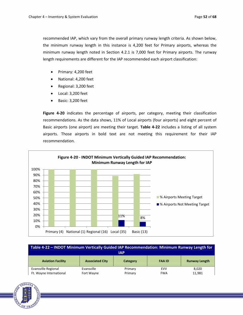
Chapter 4 – Inventory & System Evaluation Page 52 of 68
recommended IAP, which vary from the overall primary runway length criteria. As shown below, the minimum runway length in this instance is 4,200 feet for Primary airports, whereas the
minimum runway length noted in Section 4.2.1 is 7,000 feet for Primary airports. The runway length requirements are different for the IAP recommended each airport classification:
• Primary: 4,200 feet
• National: 4,200 feet
• Regional: 3,200 feet
• Local: 3,200 feet
• Basic: 3,200 feet
Figure 4-20 indicates the percentage of airports, per category, meeting their classification recommendations. As the data shows, 11% of Local airports (four airports) and eight percent of
Basic airports (one airport) are meeting their target. Table 4-22 includes a listing of all system airports. Those airports in bold text are not meeting this requirement for their IAP
recommendation.
Table 4-22 – INDOT Minimum Vertically Guided IAP Recommendation: Minimum Runway Length for IAP
Aviation Facility Associated City Category FAA ID Runway Length
Evansville Regional Evansville Primary EVV 8,020 Ft. Wayne International Fort Wayne Primary FWA 11,981
11% 8%
0%10%20%30%40%50%60%70%80%90%
100%
Primary (4) National (1) Regional (16) Local (35) Basic (13)
Figure 4-20 - INDOT Minimum Vertically Guided IAP Recommendation: Minimum Runway Length for IAP
% Airports Meeting Target
% Airports Not Meeting Target

Chapter 4 – Inventory & System Evaluation Page 53 of 68
Table 4-22 – INDOT Minimum Vertically Guided IAP Recommendation: Minimum Runway Length for IAP
Aviation Facility Associated City Category FAA ID Runway Length
Indianapolis International Indianapolis Primary IND 11,200 South Bend Regional South Bend Primary SBN 8,414 Gary/Chicago Gary National GYY 7,003 DeKalb County Auburn Regional GWB 5,000 Monroe County Bloomington Regional BMG 6,500 Columbus Municipal Columbus Regional BAK 6,400 Elkhart Municipal Elkhart Regional EKM 6,500 Goshen Municipal Goshen Regional GSH 6,050 Huntingburg Airport Huntingburg Regional HNB 5,000 Eagle Creek Airpark Indianapolis Regional EYE 4,200 Indianapolis Executive Indianapolis Regional TYQ 5,500 Indianapolis Metropolitan Indianapolis Regional UMP 3,850 Indianapolis Regional Indianapolis Regional MQJ 5,500 Clark County Jeffersonville Regional JVY 5,500 Purdue University Lafayette Regional LAF 6,600 Marion Municipal Marion Regional MZZ 6,000 Delaware County Muncie Regional MIE 6,500 Porter County Regional Valparaiso Regional VPZ 7,001 Warsaw Municipal Warsaw Regional ASW 6,002 Anderson Municipal Anderson Local AID 5,400 Steuben Co.-Tri State Angola Local ANQ 4,540 Virgil I. Grissom Bedford Local BFR 4,501 Brazil-Clay County Brazil Local 0I2 2,941 Crawfordsville Municipal Crawfordsville Local CFJ 4,500 Smith Field Fort Wayne Local SMD 3,124 Putnam County Greencastle Local 4I7 4,987 Greensburg-Decatur County Greensburg Local I34 3,433 Griffith-Merrillville Griffith Local 05C 4,900 Huntington Municipal Huntington Local HHG 5,003 Greenwood Municipal Indianapolis Local HFY 4,901 Hendricks County Indianapolis Local 2R2 4,400 Kendallville Municipal Kendallville Local C62 4,400 Starke County Knox Local OXI 4,401 Kokomo Municipal Kokomo Local OKK 5,201 LaPorte Municipal LaPorte Local PPO 5,000 Madison Municipal Madison Local IMS 5,000 Michigan City Municipal Michigan City Local MGC 4,100 White County Monticello Local MCX 4,002 New Castle-Henry Co. New Castle Local UWL 4,002 North Vernon Municipal North Vernon Local OVO 5,002 Paoli Municipal Paoli Local I42 2,793 Peru Municipal Peru Local I76 4,400 Plymouth Municipal Plymouth Local C65 4,400 Portland Municipal Portland Local PLD 4,002 Jasper County Rensselaer Local RZL 4,001 Richmond Municipal Richmond Local RID 5,500 Salem Municipal Salem Local I83 2,738 Freeman Municipal Seymour Local SER 5,500 Shelbyville Municipal Shelbyville Local GEZ 5,000

Chapter 4 – Inventory & System Evaluation Page 54 of 68
Table 4-22 – INDOT Minimum Vertically Guided IAP Recommendation: Minimum Runway Length for IAP
Aviation Facility Associated City Category FAA ID Runway Length
Sheridan Sheridan Local 5I4 3,760 Sullivan County Sullivan Local SIV 4,360 Terre Haute International Terre Haute Local HUF 9,020 Wabash Municipal Wabash Local IWH 4,401 Daviess County Washington Local DCY 4,621 Clinton Clinton Basic 1I7 3,750 Mettel Field Connersville Basic CEV 6,503 Delphi Municipal Delphi Basic 1I9 2,898 Frankfort Municipal Frankfort Basic FKR 5,000 French Lick Municipal French Lick Basic FRH 5,500 Ind. Downtown Heliport* Indianapolis Basic 8A4 60 Kentland Municipal Kentland Basic 50I 3,504 Boone County Lebanon Basic 6I4 3,600 Logansport Municipal Logansport Basic GGP 5,001 Fulton County Rochester Basic RCR 5,001 Perry County Municipal Tell City Basic TEL 4,400 Arens Field Winamac Basic RWN 4,200 Randolph County Winchester Basic I22 4,300 Note: Airports in BOLD text are not meeting the recommendation. *The heliport is not included in this evaluation
4.3.4.iii Runway Markings & Signage
The requirements of FAA AC 150/5300-13 for runway markings and signage are different for each
airport classification depending on its IAP recommendation:
• Primary: Precision markings with a hold position setback of 250 feet
• National: Precision markings with a hold position setback of 250 feet
• Regional: Non-precision markings with a hold position setback of 250 feet (200 feet <=A/B-II)
• Local: Non-precision markings with a hold position setback of 250 feet (200’<A/B-II, 125’ <=A/B-I)
• Basic: Non-precision markings with a hold position setback of 200 feet (125 feet <= A/B-I)
As shown in Figure 4-21, 25% of Regional airports (four airports), 54% of Local airports (19
airports), and 69% of Basic airports (nine airports) are not meeting their requirement. Table 4-23 includes a listing of all system airports. Those airports in bold text are not meeting this
requirement for their IAP recommendation.

Chapter 4 – Inventory & System Evaluation Page 55 of 68
Table 4-23 – INDOT Minimum Vertically Guided IAP Recommendation: Runway Markings and Signage
Aviation Facility Associated City Category FAA ID Runway Markings
Meets Hold Position Setback
Evansville Regional Evansville Primary EVV PRECISION Y Ft. Wayne International Fort Wayne Primary FWA PRECISION Y Indianapolis International Indianapolis Primary IND PRECISION Y South Bend Regional South Bend Primary SBN PRECISION Y Gary/Chicago Gary National GYY PRECISION Y DeKalb County Auburn Regional GWB PRECISION Y Monroe County Bloomington Regional BMG PRECISION Y Columbus Municipal Columbus Regional BAK PRECISION Y Elkhart Municipal Elkhart Regional EKM PRECISION Y Goshen Municipal Goshen Regional GSH PRECISION Y Huntingburg Airport Huntingburg Regional HNB NON-PREC Y Eagle Creek Airpark Indianapolis Regional EYE NON-PREC N Indianapolis Executive Indianapolis Regional TYQ PRECISION Y Indianapolis Metropolitan Indianapolis Regional UMP NON-PREC N Indianapolis Regional Indianapolis Regional MQJ PRECISION Y Clark County Jeffersonville Regional JVY PRECISION N Purdue University Lafayette Regional LAF PRECISION N Marion Municipal Marion Regional MZZ PRECISION Y Delaware County Muncie Regional MIE PRECISION Y Porter County Regional Valparaiso Regional VPZ PRECISION Y Warsaw Municipal Warsaw Regional ASW PRECISION Y Anderson Municipal Anderson Local AID PRECISION N Steuben Co.-Tri State Angola Local ANQ NON-PREC N Virgil I. Grissom Bedford Local BFR NON-PREC Y Brazil-Clay County Brazil Local 0I2 BASIC Y Crawfordsville Municipal Crawfordsville Local CFJ NON-PREC Y Smith Field Fort Wayne Local SMD BASIC Y Putnam County Greencastle Local 4I7 NON-PREC Y
25%
54%
69%
0%10%20%30%40%50%60%70%80%90%
100%
Primary (4) National (1) Regional (16) Local (35) Basic (13)
Figure 4-21 - INDOT Minimum Vertically Guided IAP Recommendation: Runway Markings
% Airports Meeting Target
% Airports Not Meeting Target

Chapter 4 – Inventory & System Evaluation Page 56 of 68
Table 4-23 – INDOT Minimum Vertically Guided IAP Recommendation: Runway Markings and Signage
Aviation Facility Associated City Category FAA ID Runway Markings
Meets Hold Position Setback
Greensburg-Decatur County Greensburg Local I34 BASIC N Griffith-Merrillville Griffith Local 05C BASIC Y Huntington Municipal Huntington Local HHG NON-PREC Y Greenwood Municipal Indianapolis Local HFY NON-PREC N Hendricks County Indianapolis Local 2R2 NON-PREC N Kendallville Municipal Kendallville Local C62 NON-PREC Y Starke County Knox Local OXI NON-PREC N Kokomo Municipal Kokomo Local OKK PRECISION Y LaPorte Municipal LaPorte Local PPO NON-PREC Y Madison Municipal Madison Local IMS NON-PREC N Michigan City Municipal Michigan City Local MGC NON-PREC N White County Monticello Local MCX NON-PREC N New Castle-Henry Co. New Castle Local UWL NON-PREC N North Vernon Municipal North Vernon Local OVO NON-PREC Y Paoli Municipal Paoli Local I42 BASIC N Peru Municipal Peru Local I76 NON-PREC Y Plymouth Municipal Plymouth Local C65 BASIC N Portland Municipal Portland Local PLD NON-PREC Y Jasper County Rensselaer Local RZL NON-PREC Y Richmond Municipal Richmond Local RID PRECISION Y Salem Municipal Salem Local I83 BASIC N Freeman Municipal Seymour Local SER NON-PREC N Shelbyville Municipal Shelbyville Local GEZ NON-PREC Y Sheridan Sheridan Local 5I4 BASIC N Sullivan County Sullivan Local SIV NON-PREC Y Terre Haute International Terre Haute Local HUF PRECISION Y Wabash Municipal Wabash Local IWH NON-PREC Y Daviess County Washington Local DCY NON-PREC N Clinton Clinton Basic 1I7 BASIC N Mettel Field Connersville Basic CEV BASIC Y Delphi Municipal Delphi Basic 1I9 BASIC Y Frankfort Municipal Frankfort Basic FKR NON-PREC Y French Lick Municipal French Lick Basic FRH NON-PREC Y Ind. Downtown Heliport Indianapolis Basic 8A4 NON-PREC Y Kentland Municipal Kentland Basic 50I BASIC Y Boone County Lebanon Basic 6I4 BASIC N Logansport Municipal Logansport Basic GGP NON-PREC N Fulton County Rochester Basic RCR NON-PREC N Perry County Municipal Tell City Basic TEL BASIC N Arens Field Winamac Basic RWN NON-PREC N Randolph County Winchester Basic I22 NON-PREC Y
Note: Airports in BOLD text are not meeting the recommendation.
4.3.4.iv Full Parallel Taxiway or Comparable
As detailed in Chapter 2, full parallel taxiways extend the entire length of a runway providing
access to each runway end. While some airports did not have a standard parallel taxiway at the
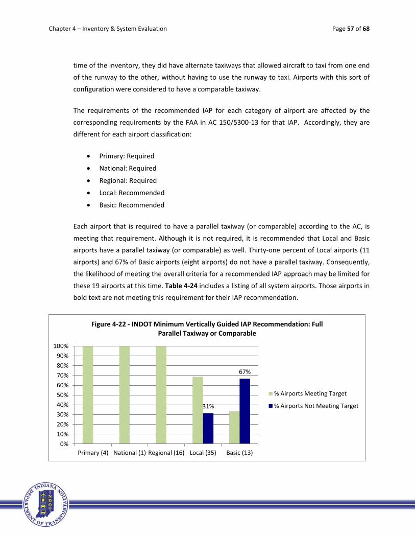
Chapter 4 – Inventory & System Evaluation Page 57 of 68
time of the inventory, they did have alternate taxiways that allowed aircraft to taxi from one end of the runway to the other, without having to use the runway to taxi. Airports with this sort of
configuration were considered to have a comparable taxiway.
The requirements of the recommended IAP for each category of airport are affected by the corresponding requirements by the FAA in AC 150/5300-13 for that IAP. Accordingly, they are
different for each airport classification:
• Primary: Required
• National: Required
• Regional: Required
• Local: Recommended
• Basic: Recommended
Each airport that is required to have a parallel taxiway (or comparable) according to the AC, is
meeting that requirement. Although it is not required, it is recommended that Local and Basic airports have a parallel taxiway (or comparable) as well. Thirty-one percent of Local airports (11
airports) and 67% of Basic airports (eight airports) do not have a parallel taxiway. Consequently, the likelihood of meeting the overall criteria for a recommended IAP approach may be limited for
these 19 airports at this time. Table 4-24 includes a listing of all system airports. Those airports in bold text are not meeting this requirement for their IAP recommendation.
31%
67%
0%10%20%30%40%50%60%70%80%90%
100%
Primary (4) National (1) Regional (16) Local (35) Basic (13)
Figure 4-22 - INDOT Minimum Vertically Guided IAP Recommendation: Full Parallel Taxiway or Comparable
% Airports Meeting Target
% Airports Not Meeting Target

Chapter 4 – Inventory & System Evaluation Page 58 of 68
Table 4-24 – INDOT Minimum Vertically Guided IAP Recommendation: Full Parallel Taxiway or Comparable
Aviation Facility Associated City Category FAA ID Full Taxiway*
Evansville Regional Evansville Primary EVV Y Ft. Wayne International Fort Wayne Primary FWA Y Indianapolis International Indianapolis Primary IND Y South Bend Regional South Bend Primary SBN Y Gary/Chicago Gary National GYY Y DeKalb County Auburn Regional GWB Y Monroe County Bloomington Regional BMG Y Columbus Municipal Columbus Regional BAK Y Elkhart Municipal Elkhart Regional EKM Y Goshen Municipal Goshen Regional GSH Y Huntingburg Airport Huntingburg Regional HNB Y Eagle Creek Airpark Indianapolis Regional EYE Y Indianapolis Executive Indianapolis Regional TYQ Y Indianapolis Metropolitan Indianapolis Regional UMP Y Indianapolis Regional Indianapolis Regional MQJ Y Clark County Jeffersonville Regional JVY Y Purdue University Lafayette Regional LAF Y Marion Municipal Marion Regional MZZ Y Delaware County Muncie Regional MIE Y Porter County Regional Valparaiso Regional VPZ Y Warsaw Municipal Warsaw Regional ASW Y Anderson Municipal Anderson Local AID Y Steuben Co.-Tri State Angola Local ANQ Y Virgil I. Grissom Bedford Local BFR N Brazil-Clay County Brazil Local 0I2 N Crawfordsville Municipal Crawfordsville Local CFJ Y Smith Field Fort Wayne Local SMD N Putnam County Greencastle Local 4I7 Y Greensburg-Decatur County Greensburg Local I34 N Griffith-Merrillville Griffith Local 05C N Huntington Municipal Huntington Local HHG Y Greenwood Municipal Indianapolis Local HFY Y Hendricks County Indianapolis Local 2R2 Y Kendallville Municipal Kendallville Local C62 Y Starke County Knox Local OXI Y Kokomo Municipal Kokomo Local OKK Y LaPorte Municipal LaPorte Local PPO Y Madison Municipal Madison Local IMS Y Michigan City Municipal Michigan City Local MGC Y White County Monticello Local MCX Y New Castle-Henry Co. New Castle Local UWL N North Vernon Municipal North Vernon Local OVO Y Paoli Municipal Paoli Local I42 N Peru Municipal Peru Local I76 Y Plymouth Municipal Plymouth Local C65 N Portland Municipal Portland Local PLD Y Jasper County Rensselaer Local RZL Y Richmond Municipal Richmond Local RID Y Salem Municipal Salem Local I83 N

Chapter 4 – Inventory & System Evaluation Page 59 of 68
Table 4-24 – INDOT Minimum Vertically Guided IAP Recommendation: Full Parallel Taxiway or Comparable
Aviation Facility Associated City Category FAA ID Full Taxiway*
Freeman Municipal Seymour Local SER Y Shelbyville Municipal Shelbyville Local GEZ Y Sheridan Sheridan Local 5I4 N Sullivan County Sullivan Local SIV Y Terre Haute International Terre Haute Local HUF Y Wabash Municipal Wabash Local IWH Y Daviess County Washington Local DCY N Clinton Clinton Basic 1I7 N Mettel Field Connersville Basic CEV Y Delphi Municipal Delphi Basic 1I9 N Frankfort Municipal Frankfort Basic FKR N French Lick Municipal French Lick Basic FRH N Ind. Downtown Heliport** Indianapolis Basic 8A4 NA Kentland Municipal Kentland Basic 50I N Boone County Lebanon Basic 6I4 N Logansport Municipal Logansport Basic GGP Y Fulton County Rochester Basic RCR Y Perry County Municipal Tell City Basic TEL N Arens Field Winamac Basic RWN N Randolph County Winchester Basic I22 Y *Airports had to have either a full parallel taxiway, or alternate taxiways that allowed aircraft to taxi from one end of the runway to the other, without having to use the runway to taxi. **The heliport is not included in this evaluation. Note: Airports in BOLD text are not meeting the recommendation.
4.3.4.v Runway Edge Lights
Again, the AC 150/5300-13 criteria for specific IAP minimum visibility and ceiling heights are slightly different than the INDOT criteria for runway edge lighting outlined in Section 4.1.4 of this document. As previously mentioned, runway lighting is used to define the edges of a runway
during nighttime and low visibility conditions. Runway lighting is classified into three types of systems based upon illumination intensity and level of control: High Intensity Runway Lighting
(HIRL), Medium Intensity Runway Lighting (MIRL), and Low Intensity Runway Lighting (LIRL). HIRL systems offer pilots the greatest lighting intensity and control, while LIRL systems have a single
illumination setting. (Note: Runway edge lighting is required for night minimums. High intensity lights are required for runway visual range-based minimums.)
The requirements of FAA AC 150/5300-13 are different for each airport category depending on
the recommended IAP for the category:

Chapter 4 – Inventory & System Evaluation Page 60 of 68
• Primary: HIRL/MIRL
• National: HIRL/MIRL
• Regional: HIRL/MIRL
• Local: MIRL/LIRL
• Basic: MIRL/LIRL
As Figure 4-22 illustrates, the majority of system airports are meeting their runway edge lighting
requirement, with only 3% of the Local category (one airport) and 15% of the Basic category (two airports) not meeting it. Table 4-25 includes a listing of all system airports. Those airports in bold
text are not meeting this requirement for their IAP recommendation.
Table 4-25 – INDOT Minimum Vertically Guided IAP Recommendation: Runway Edge Lights
Aviation Facility Associated City Category FAA ID Runway Lights
Evansville Regional Evansville Primary EVV HIRL Ft. Wayne International Fort Wayne Primary FWA HIRL Indianapolis International Indianapolis Primary IND HIRL South Bend Regional South Bend Primary SBN HIRL Gary/Chicago Gary National GYY HIRL DeKalb County Auburn Regional GWB MIRL Monroe County Bloomington Regional BMG HIRL Columbus Municipal Columbus Regional BAK HIRL Elkhart Municipal Elkhart Regional EKM HIRL Goshen Municipal Goshen Regional GSH HIRL Huntingburg Airport Huntingburg Regional HNB MIRL
3%
15%
0%10%20%30%40%50%60%70%80%90%
100%
Primary (4) National (1) Regional(16)
Local (35) Basic (13)
Figure 4-22 - INDOT Minimum Vertically Guided IAP Recommendation: Runway Edge Lights
% Airports Meeting Target
% Airports Not Meeting Target

Chapter 4 – Inventory & System Evaluation Page 61 of 68
Table 4-25 – INDOT Minimum Vertically Guided IAP Recommendation: Runway Edge Lights
Aviation Facility Associated City Category FAA ID Runway Lights
Eagle Creek Airpark Indianapolis Regional EYE MIRL Indianapolis Executive Indianapolis Regional TYQ HIRL Indianapolis Metropolitan Indianapolis Regional UMP MIRL Indianapolis Regional Indianapolis Regional MQJ HIRL Clark County Jeffersonville Regional JVY MIRL Purdue University Lafayette Regional LAF HIRL Marion Municipal Marion Regional MZZ HIRL Delaware County Muncie Regional MIE HIRL Porter County Regional Valparaiso Regional VPZ HIRL Warsaw Municipal Warsaw Regional ASW HIRL Anderson Municipal Anderson Local AID MIRL Steuben Co.-Tri State Angola Local ANQ MIRL Virgil I. Grissom Bedford Local BFR MIRL Brazil-Clay County Brazil Local 0I2 LIRL Crawfordsville Municipal Crawfordsville Local CFJ MIRL Smith Field Fort Wayne Local SMD MIRL Putnam County Greencastle Local 4I7 MIRL Greensburg-Decatur County Greensburg Local I34 MIRL Griffith-Merrillville Griffith Local 05C MIRL Huntington Municipal Huntington Local HHG MIRL Greenwood Municipal Indianapolis Local HFY HIRL Hendricks County Indianapolis Local 2R2 MIRL Kendallville Municipal Kendallville Local C62 MIRL Starke County Knox Local OXI MIRL Kokomo Municipal Kokomo Local OKK HIRL LaPorte Municipal LaPorte Local PPO MIRL Madison Municipal Madison Local IMS HIRL Michigan City Municipal Michigan City Local MGC MIRL White County Monticello Local MCX MIRL New Castle-Henry Co. New Castle Local UWL MIRL North Vernon Municipal North Vernon Local OVO MIRL Paoli Municipal Paoli Local I42 MIRL Peru Municipal Peru Local I76 MIRL Plymouth Municipal Plymouth Local C65 MIRL Portland Municipal Portland Local PLD MIRL Jasper County Rensselaer Local RZL MIRL Richmond Municipal Richmond Local RID MIRL Salem Municipal Salem Local I83 MIRL Freeman Municipal Seymour Local SER MIRL Shelbyville Municipal Shelbyville Local GEZ MIRL Sheridan Sheridan Local 5I4 NON-STND Sullivan County Sullivan Local SIV MIRL Terre Haute International Terre Haute Local HUF HIRL Wabash Municipal Wabash Local IWH MIRL Daviess County Washington Local DCY MIRL Clinton Clinton Basic 1I7 NO Mettel Field Connersville Basic CEV MIRL Delphi Municipal Delphi Basic 1I9 MIRL Frankfort Municipal Frankfort Basic FKR MIRL

Chapter 4 – Inventory & System Evaluation Page 62 of 68
Table 4-25 – INDOT Minimum Vertically Guided IAP Recommendation: Runway Edge Lights
Aviation Facility Associated City Category FAA ID Runway Lights
French Lick Municipal French Lick Basic FRH MIRL Ind. Downtown Heliport Indianapolis Basic 8A4 Yes Kentland Municipal Kentland Basic 50I HIRL Boone County Lebanon Basic 6I4 LIRL NSTD Logansport Municipal Logansport Basic GGP MIRL Fulton County Rochester Basic RCR MIRL Perry County Municipal Tell City Basic TEL MIRL Arens Field Winamac Basic RWN LIRL Randolph County Winchester Basic I22 MIRL
Note: Airports in BOLD text are not meeting the recommendation.
4.3.4.vi Approach Lights
As outlined in Chapter 2, approach lights (AL) provide a means to transition from instrument
flight to visual flight for landing. Operational requirements dictate the sophistication and configuration of the approach lighting system for a particular runway. A common approach
lighting system is the Medium Intensity Approach Lighting System with Runway Alignment Indicator Lights (MALSR). Other systems include the High Intensity Approach Lighting System with
Sequenced Flashing Lights (ALSF), and the Simplified Short Approach Lighting System with Runway Alignment Indicator Lights (SSALR).
The requirements of FAA AC 150/5300-13 to meet the specific criteria for the IAP are different
for each airport based upon their recommended IAP minimums:
• Primary: MALSR, SSALR, ALSF
• National: MALSR, SSALR, ALSF
• Regional: Recommended
• Local: Recommended
• Basic: Recommended
Approach lighting is required for Primary and National airports, but is only recommended for
Regional, Local, and Basic airports. As shown in Figure 4-23, all airports in the system that are required to have approach lighting for their recommended IAP are meeting this target. However,
31% of Regional airports (five airports), 83% of Local airports (29 airports), and 85% of Basic airports (11 airports) are not meeting it where the FAA AC “recommends” it. Table 4-26 includes

Chapter 4 – Inventory & System Evaluation Page 63 of 68
a listing of all system airports. Those airports in bold text are not meeting this requirement/recommendation.
Table 4-26 – INDOT Minimum Vertically Guided IAP Recommendation: Approach Lights
Aviation Facility Associated City Category FAA ID Approach Lights
Evansville Regional Evansville Primary EVV MALSR Ft. Wayne International Fort Wayne Primary FWA ALSF2 Indianapolis International Indianapolis Primary IND ALSF2 South Bend Regional South Bend Primary SBN MALSR Gary/Chicago Gary National GYY MALSR DeKalb County Auburn Regional GWB MALSR Monroe County Bloomington Regional BMG MALSR Columbus Municipal Columbus Regional BAK MALSR Elkhart Municipal Elkhart Regional EKM MALSR Goshen Municipal Goshen Regional GSH N Huntingburg Airport Huntingburg Regional HNB N Eagle Creek Airpark Indianapolis Regional EYE MALS Indianapolis Executive Indianapolis Regional TYQ N Indianapolis Metropolitan Indianapolis Regional UMP N Indianapolis Regional Indianapolis Regional MQJ MALSR Clark County Jeffersonville Regional JVY MALSR Purdue University Lafayette Regional LAF MALSR Marion Municipal Marion Regional MZZ MALSR Delaware County Muncie Regional MIE MALSR Porter County Regional Valparaiso Regional VPZ MALSR Warsaw Municipal Warsaw Regional ASW N Anderson Municipal Anderson Local AID MALSF Steuben Co.-Tri State Angola Local ANQ N Virgil I. Grissom Bedford Local BFR N
31%
83% 85%
0%10%20%30%40%50%60%70%80%90%
100%
Primary (4) National (1) Regional (16) Local (35) Basic (13)
Figure 4-23 - INDOT Minimum Vertically Guided IAP Recommendation: Approach Lights
% Airports Meeting Target
% Airports Not Meeting Target

Chapter 4 – Inventory & System Evaluation Page 64 of 68
Table 4-26 – INDOT Minimum Vertically Guided IAP Recommendation: Approach Lights
Aviation Facility Associated City Category FAA ID Approach Lights
Brazil-Clay County Brazil Local 0I2 N Crawfordsville Municipal Crawfordsville Local CFJ N Smith Field Fort Wayne Local SMD N Putnam County Greencastle Local 4I7 N Greensburg-Decatur County Greensburg Local I34 N Griffith-Merrillville Griffith Local 05C N Huntington Municipal Huntington Local HHG N Greenwood Municipal Indianapolis Local HFY N Hendricks County Indianapolis Local 2R2 N Kendallville Municipal Kendallville Local C62 N Starke County Knox Local OXI N Kokomo Municipal Kokomo Local OKK MALSR LaPorte Municipal LaPorte Local PPO N Madison Municipal Madison Local IMS MALSF Michigan City Municipal Michigan City Local MGC N White County Monticello Local MCX N New Castle-Henry Co. New Castle Local UWL N North Vernon Municipal North Vernon Local OVO N Paoli Municipal Paoli Local I42 N Peru Municipal Peru Local I76 N Plymouth Municipal Plymouth Local C65 N Portland Municipal Portland Local PLD N Jasper County Rensselaer Local RZL N Richmond Municipal Richmond Local RID LDIN Salem Municipal Salem Local I83 N Freeman Municipal Seymour Local SER ODALS Shelbyville Municipal Shelbyville Local GEZ N Sheridan Sheridan Local 5I4 N Sullivan County Sullivan Local SIV N Terre Haute International Terre Haute Local HUF MALSR Wabash Municipal Wabash Local IWH N Daviess County Washington Local DCY N Clinton Clinton Basic 1I7 N Mettel Field Connersville Basic CEV MALSR Delphi Municipal Delphi Basic 1I9 N Frankfort Municipal Frankfort Basic FKR N French Lick Municipal French Lick Basic FRH N Ind. Downtown Heliport Indianapolis Basic 8A4 ODALS Kentland Municipal Kentland Basic 50I N Boone County Lebanon Basic 6I4 N Logansport Municipal Logansport Basic GGP N Fulton County Rochester Basic RCR N Perry County Municipal Tell City Basic TEL N Arens Field Winamac Basic RWN N Randolph County Winchester Basic I22 N
Note: Airports in BOLD text are not meeting the recommendation.
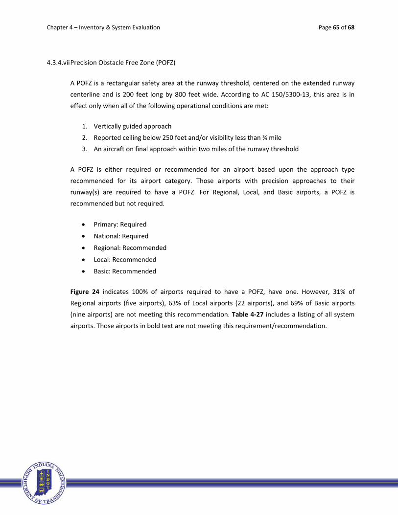
Chapter 4 – Inventory & System Evaluation Page 65 of 68
4.3.4.vii Precision Obstacle Free Zone (POFZ)
A POFZ is a rectangular safety area at the runway threshold, centered on the extended runway
centerline and is 200 feet long by 800 feet wide. According to AC 150/5300-13, this area is in effect only when all of the following operational conditions are met:
1. Vertically guided approach
2. Reported ceiling below 250 feet and/or visibility less than ¾ mile 3. An aircraft on final approach within two miles of the runway threshold
A POFZ is either required or recommended for an airport based upon the approach type
recommended for its airport category. Those airports with precision approaches to their runway(s) are required to have a POFZ. For Regional, Local, and Basic airports, a POFZ is
recommended but not required.
• Primary: Required
• National: Required
• Regional: Recommended
• Local: Recommended
• Basic: Recommended
Figure 24 indicates 100% of airports required to have a POFZ, have one. However, 31% of
Regional airports (five airports), 63% of Local airports (22 airports), and 69% of Basic airports (nine airports) are not meeting this recommendation. Table 4-27 includes a listing of all system
airports. Those airports in bold text are not meeting this requirement/recommendation.

Chapter 4 – Inventory & System Evaluation Page 66 of 68
Table 4-27 - INDOT Minimum Vertically Guided IAP Recommendation: Precision Obstacle Free Zone
Aviation Facility Associated City Category FAA ID POFZ
Evansville Regional Evansville Primary EVV Y Ft. Wayne International Fort Wayne Primary FWA Y Indianapolis International Indianapolis Primary IND Y South Bend Regional South Bend Primary SBN Y Gary/Chicago Gary National GYY Y DeKalb County Auburn Regional GWB N Monroe County Bloomington Regional BMG Y Columbus Municipal Columbus Regional BAK Y Elkhart Municipal Elkhart Regional EKM N Goshen Municipal Goshen Regional GSH Y Huntingburg Airport Huntingburg Regional HNB Y Eagle Creek Airpark Indianapolis Regional EYE N Indianapolis Executive Indianapolis Regional TYQ Y Indianapolis Metropolitan Indianapolis Regional UMP N Indianapolis Regional Indianapolis Regional MQJ Y Clark County Jeffersonville Regional JVY Y Purdue University Lafayette Regional LAF Y Marion Municipal Marion Regional MZZ Y Delaware County Muncie Regional MIE N Porter County Regional Valparaiso Regional VPZ Y Warsaw Municipal Warsaw Regional ASW Y Anderson Municipal Anderson Local AID N Steuben Co.-Tri State Angola Local ANQ N Virgil I. Grissom Bedford Local BFR N Brazil-Clay County Brazil Local 0I2 N Crawfordsville Municipal Crawfordsville Local CFJ Y Smith Field Fort Wayne Local SMD N Putnam County Greencastle Local 4I7 Y
31%
63% 69%
0%10%20%30%40%50%60%70%80%90%
100%
Primary (4) National (1) Regional (16) Local (35) Basic (13)
Figure 4-24 - INDOT Minimum Vertically Guided IAP Recommendation: Precision Obstacle Free Zone
% Airports Meeting Target
% Airports Not Meeting Target

Chapter 4 – Inventory & System Evaluation Page 67 of 68
Table 4-27 - INDOT Minimum Vertically Guided IAP Recommendation: Precision Obstacle Free Zone
Aviation Facility Associated City Category FAA ID POFZ
Greensburg-Decatur County Greensburg Local I34 N Griffith-Merrillville Griffith Local 05C N Huntington Municipal Huntington Local HHG N Greenwood Municipal Indianapolis Local HFY N Hendricks County Indianapolis Local 2R2 N Kendallville Municipal Kendallville Local C62 N Starke County Knox Local OXI N Kokomo Municipal Kokomo Local OKK Y LaPorte Municipal LaPorte Local PPO Y Madison Municipal Madison Local IMS Y Michigan City Municipal Michigan City Local MGC N White County Monticello Local MCX N New Castle-Henry Co. New Castle Local UWL Y North Vernon Municipal North Vernon Local OVO Y Paoli Municipal Paoli Local I42 N Peru Municipal Peru Local I76 N Plymouth Municipal Plymouth Local C65 N Portland Municipal Portland Local PLD N Jasper County Rensselaer Local RZL N Richmond Municipal Richmond Local RID Y Salem Municipal Salem Local I83 N Freeman Municipal Seymour Local SER Y Shelbyville Municipal Shelbyville Local GEZ Y Sheridan Sheridan Local 5I4 N Sullivan County Sullivan Local SIV Y Terre Haute International Terre Haute Local HUF Y Wabash Municipal Wabash Local IWH N Daviess County Washington Local DCY Y Clinton Clinton Basic 1I7 N Mettel Field Connersville Basic CEV Y Delphi Municipal Delphi Basic 1I9 N Frankfort Municipal Frankfort Basic FKR Y French Lick Municipal French Lick Basic FRH N Ind. Downtown Heliport Indianapolis Basic 8A4 Y Kentland Municipal Kentland Basic 50I N Boone County Lebanon Basic 6I4 N Logansport Municipal Logansport Basic GGP Y Fulton County Rochester Basic RCR N Perry County Municipal Tell City Basic TEL N Arens Field Winamac Basic RWN N Randolph County Winchester Basic I22 N
Note: Airports in BOLD text are not meeting the requirement/recommendation.

Chapter 4 – Inventory & System Evaluation Page 68 of 68
4.4 Summary
Overall, the system is doing fairly well at meeting the requirements and recommendations outlined in
this Chapter; however, there is room for improvement. Airports in the Primary and National categories are meeting nearly every individual requirement and recommendation. Unfortunately, a number of
airports in the Regional, Local, and Basic categories are not meeting their targets. Table 4-28 indicates significant gaps in a few of the targets, such as perimeter fencing, zoning/land use coordination,
obstruction survey, minimum standards, ceiling minimums, approved ALP, and runway markings/signage. These gaps are the basis for the system recommendations presented in Chapter 6.
Table 4-28 – Number of Airports (per classification) Not Meeting Requirements/Recommendations
Criteria Primary National Regional Local Basic Total
Minimum Standards 1 24 11 36 Pavement Maintenance Mgmt. Program 1 1 2 Weather Reporting 14 7 21 Runway Lights 2 1 3 Full Parallel Taxiway (or comparable) 11 N/A 11 24-Hour Fuel Availability N/A 0 Taxiway Lights 2 25 N/A 27 Primary Runway Length 2 4 1 7 Primary Runway Strength 3 19 4 26 Primary Runway Grooving 2 23 N/A 25 Primary Runway End Identifier Lights (REIL) 6 N/A 6 Primary Visual Slope Indicators (VSI) or Approach Lights 3 N/A 3 Perimeter Fencing 8 27 11 46 Zoning/Land Use Coordination 1 9 26 10 46 Visibility Minimums 2 5 3 10 Ceiling Minimums 1 25 8 34 Obstruction Survey 8 29 9 46 Approved Airport Layout Plan 1 25 8 34 Minimum Runway Length 4 1 5 Runway Markings/Signage 4 19 9 32 Full Parallel Taxiway (or comparable) 11 8 19 Runway Edge Lights 1 2 3 Approach Lights 5 29 11 45 Precision Obstacle Free Zone (POFZ) 5 22 9 36