Embed Size (px)
Citation preview

CHAPTER 4: CURRENT TRANSPORTATION SYSTEM Mobility has a significant impact on quality of life in the Kalamazoo Metropolitan
Planning area. Our transportation system consists of a historically significant and
complex network of state and federal highways, local streets and roadways, transit
services, a series of bicycle and pedestrian multi-use paths, a railway line, and the
Kalamazoo – Battle Creek International Airport. It is of utmost importance that the
transportation system satisfies mobility needs and provides convenient, safe, and
efficient transportation choices.
Roadway System The MPO is primarily concerned with roadways of “Regional Significance” – those
roadways eligible to receive federal funding. The MPO is also interested in the
connectivity and functionality of the network as a whole and how that may impact the
“Regionally Significant” roadway network. Federal statues in the Code of Federal
Regulations (CFR) require that public roadways be classified based on the
characteristics of the service (mobility
and access) they provide. Functional
Classification is an analytic tool that the
MPO uses to plan roads and highways
and to determine the needs and
priorities for transportation funds.
Functional Classification affects some
design and access features, the rules
regulating a roadway’s use, and in
some cases the land use adjacent to it.
The higher the level of motor vehicle mobility required of a facility, the higher its
Functional Classification.
A REGIONALLY SIGNIFICANT PROJECT IS A
TRANSPORTATION PROJECT THAT IS ON A FACILITY
THAT SERVES REGIONAL TRANSPORTATION NEEDS AND
WOULD NORMALLY BE INCLUDED IN THE MODELING OF
THE METROPOLITAN AREA’S TRANSPORTATION
NETWORK.
23 CFR Sec. 450.104

Figure 4-1 shows Functional Classifications defined by the level of mobility versus
access that the roads provide, as follows:
● Interstate: Highest mobility for vehicular traffic ● Arterials (Principal and Minor): High mobility ● Collectors (Urban, Rural Major, Rural Minor): Lower mobility/higher access for
vehicular traffic ● Local: Lowest mobility; highest access for vehicular traffic Functional Classifications recognize the need to accommodate vehicular traffic in a
manner that reduces congestion and increases connectivity to regional and urban
destinations. They also assist in defining eligibility for federal funding sources. An
inverse relationship exists between high mobility for vehicular traffic and mobility for
pedestrian, bicycle, and in many cases, transit usage. The MPO recognized this
relationship and is committed to planning for and implementing a balanced
transportation network that effectively accommodates vehicles, pedestrians, bicyclists,
and transit riders.
Transportation Corridors The U.S. Department of Transportation (USDOT), in cooperation with the states, local
officials, and MPOs, developed the National Highway System (NHS) with the purpose of
identifying the core road network that was considered critical to the nation’s economy,
defense, and mobility. The U.S. Congress approved the NHS in 1995, with the intent
that the United States would prioritize federal-aid funds appropriately to ensure the NHS
was adequately maintained. Figure 4-2 shows the NHS routes in our region.

Village ofRichland
Village ofAugusta
Villageof Climax
Villageof
VicksburgVillage of
Schoolcraft
Villa
geof
Pa
wPaw Villageof
Mattawan
Villageof Lawton
City ofKalamazoo
City ofPortage
National Function Classification for the KATS MPO Boundary
LegendRailroads
National Function ClassificationNFC
Interstate
Principal Freeway
Minor Arterial
Major Collector
Minor Collector
Local
Water Features
Cities and Villages
ACUB
MPO Boundary
0 5 10 15 202.5Miles
Michigan Geographic Data LibraryTAMC, Roadsoft
September 2020

National Highway System for the KATS MPO Area
Village ofRichland
Vil lage of
Augusta
Villageof Climax
Vill
age
of
Vic
ksbu
rgVillage ofSchoolcraft
Village
of
PawP
aw Village of
Mattawan
Villageof Lawton
City ofKalamazoo
City ofPortage
LegendInterstate
Principal Freeway
Water Features
Cities and Villages
ACUB
MPO Boundary
Source: Michigan Geographic DataLibrary, TAMC, Roadsoft
June 2021
0 5 10 15 202.5Miles
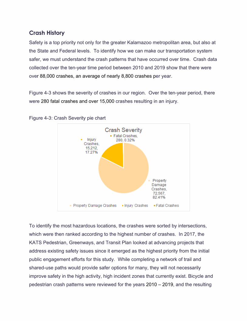
Crash History Safety is a top priority not only for the greater Kalamazoo metropolitan area, but also at
the State and Federal levels. To identify how we can make our transportation system
safer, we must understand the crash patterns that have occurred over time. Crash data
collected over the ten-year time period between 2010 and 2019 show that there were
over 88,000 crashes, an average of nearly 8,800 crashes per year.
Figure 4-3 shows the severity of crashes in our region. Over the ten-year period, there
were 280 fatal crashes and over 15,000 crashes resulting in an injury.
Figure 4-3: Crash Severity pie chart
To identify the most hazardous locations, the crashes were sorted by intersections,
which were then ranked according to the highest number of crashes. In 2017, the
KATS Pedestrian, Greenways, and Transit Plan looked at advancing projects that
address existing safety issues since it emerged as the highest priority from the initial
public engagement efforts for this study. While completing a network of trail and
shared-use paths would provide safer options for many, they will not necessarily
improve safety in the high activity, high incident zones that currently exist. Bicycle and
pedestrian crash patterns were reviewed for the years 2010 – 2019, and the resulting

trends show pockets of high crash locations throughout the KATS Region that deserve
priority for facility improvements. Pedestrian and bicyclist crash data was obtained
through the Michigan Traffic Crash Facts website, which aggregates and hosts detailed
data about reported crashes. This data was compiled and mapped to locate the densest
areas of crash activity. The densest sites became “Safety Focus Areas” and are listed
below:
● A - Michigan Avenue & Drake Road ● B - Michigan Avenue & Howard Street ● C- Paterson Street and Burdick Road ● D - Downtown Kalamazoo ● E - Westnedge Avenue from Cedar Street to Maple Street ● F - Stockbridge Avenue to Vine Street ● G - Gull Road from Riverview Drive to Inverness Lane ● H- Gull Road & Sprinkle Road ● I - Riverview Drive & Michigan Avenue ● J - 9th Street & I-94 ● K - Westnedge Avenue from Kilgore Road to Milham Avenue ● L - Westnedge Avenue & Romence Road ● M - N Grand Street & Eliza Street ● N - Portage Road & I-94
The majority of bicyclist crashes, 63%, occurred in the City of Kalamazoo followed by
the City of Portage at 15% and Kalamazoo Township with 8%. The remaining
municipalities each account for fewer than 3% of region-wide bicyclist crashes. Most
crashes occurred on smaller, lower speed roads (68%). The majority of pedestrian
crashes, 68%, occurred in the City of Kalamazoo followed by the City of Portage at 8%
and Kalamazoo Township at 6%. The remaining municipalities each account for fewer
than 4% of region-wide bicyclist crashes. The majority crashes occurred on smaller,
lower speed roads (67%). Overall, high bicycle and pedestrian crash areas tend to be
located in areas where cycling and walking are more popular, like Downtown
Kalamazoo and near Western Michigan University. Figure 4-4 shows the resulting list
of the top hazardous intersections. These intersections represent high priorities for
safety improvements. For a more detailed view and analysis of safety focus areas,

please refer to the KATS Pedestrian, Greenways and Transit Plan on the website:
https://katsmpo.org/documents/.
Figure 4-4: Safety Focus Areas
Transit and Rail System Transit The Kalamazoo Transportation Center is located on Kalamazoo Avenue between North
Burdick Street and Rose Street and houses Metro, Amtrak, and intercity bus passenger
services. The facility is the downtown transfer center for Metro’s fixed route bus system

and has a space for food and convenience purchases. Dedicated taxicab pick-up
spaces are provided near the building. Sidewalk connections provide pedestrian
access. Figure 4-5 shows the Metro fixed route bus system.
Van Buren Transit does not operate fixed route service and therefore does not have a
transfer center.
Two intercity bus companies operate regularly scheduled passenger services in and out
of the metropolitan area. Greyhound Bus Lines and Indian Trails Motorcoach are both
stationed at the Kalamazoo Transportation Center. Charter bus service is provided by
approximately seven local companies.
The Kalamazoo area is served by several locally based, independently owned taxi
companies and one limousine service. Rides are available on an on-call basis, seven
days a week, 24 hours a day for most taxi services. Due to its more rural nature,
taxicab service is limited with Van Buren County.
Metro serves as the community ridesharing office for Kalamazoo, Barry, Branch,
Calhoun, and St. Joseph counties. The office coordinates and provides updated names
and address information for people requesting ridesharing information to locations
within and out of the county area. Other activities of the community ridesharing
program include contacts with local employers to set up carpool/vanpool programs
within their companies and surveys and interviews with users of the carpool lots in the
Kalamazoo area. MDOT maintains several carpool lots in the metropolitan area.
Several organizations, including church groups, senior care centers, and special interest
providers maintain small scale transportation services for their members or clients.

Transit Existing Routes
Source: Metro Transit, KATS October 2020
S US 131
Stadium Ave
Vanderbilt Ave
W Q Ave
Oakland Dr
Moorsbridge
Rd
W Main St
Portage Rd
Barney Rd
I 94 BL
S 9th St
N US 131
E Ml Ave
Douglas Ave
Sprinkle Rd
Lovers Ln
W North St
N Riverview Dr
N 12th St
N W
estnedge Ave
W Crosstown
Pkwy
W H Ave Ravine Rd
E Michigan Ave
E Cork St
E Vine St
Howard St
N 26th S
t
Shaver Rd
Lake St
W Paterson St
Comstock Ave
Alamo Ave
S W
estnedge Ave Fulford St
N Bus US 131
Mount Olivet Rd
S 8th St
Texas D
r
E N Ave
Bronson Blvd
W Osterhout Ave
Romence Rd
E Main St
E Stockbridge Ave
S Bus US 131
Parkview Ave
Nazareth Rd
W O Ave
Schuring Rd
E G AveS 11th St
W K L Ave
Angling Rd
E Milham Ave
WhitesRd
W Centre
Ave
W N Ave
E I 94
Constitution
Blvd
W I 94
E P Ave
E S Ave
Gull R
d
S 12th St
LegendTransit Routes
Federal Aid RoadsNon-Federal Aid Roads
0 1.5 3 4.5 60.75Miles

Rail Rail freight service to the Kalamazoo area is provided by three rail carriers. Norfolk
Southern, operating on both north-south and east-west rail lines through the mid-section
of the urban area, provides freight movements between Detroit and northern Indiana
(and points beyond). Norfolk Southern also maintains a switching yard near the east
side of the city of Kalamazoo’s central business district. Grand Trunk/CN North America
operates freight movement from two rail lines which serve Kalamazoo from the
southwest, with continued service through Battle Creek and onto Detroit and Canada. A
main line connects at the southern urban area which runs to Battle Creek. Grand Trunk
maintains a switching yard near South Sprinkle Road. Grand Elk Railroad also leases
north/south track rights from Norfolk Southern Railroad and provides freight service
along this corridor between Elkhart, Indiana and Grand Rapids, Michigan. Small spur
lines serve major industrial locations near the Pfizer facilities east of Portage Road and
along the Fulford Street industrial area.
Rail passenger service is provided by Amtrak using the east-west Amtrak/Norfolk
Southern corridor between Detroit and Kalamazoo. The Amtrak station is housed in the
Kalamazoo Transportation Center located on the north side of the City of Kalamazoo’s
central business district. Passengers can reach numerous national destinations using
the Amtrak Wolverine and Blue Water routes that pass-through Kalamazoo.
In 2012, the Michigan Department of Transportation (MDOT), Federal Railroad
Administration (FRA) and Norfolk Southern Railway Co. signed a sales agreement that
transferred ownership of 135 miles of Norfolk Southern railroad to MDOT for $140
million. The line is part of Amtrak’s Wolverine and Blue Water passenger rail services
between Kalamazoo and Dearborn. This purchase was one step in a multi-step
process that will pave the way for track improvements designed to accommodate
passenger train speeds up to 110 mph. This will reduce travel time between Detroit and
Chicago, reducing the overall trip time between the two cities to about five hours.
MDOT has aggressively promoted the development of this corridor and has completed
work towards high speed train service including in-cab signaling and improved road

crossings between Kalamazoo and the state line west of Kalamazoo. Details of
passenger and freight rail planning activities are included in MDOT’s MI Transportation
Plan which is available from the Michigan Department of Transportation’s website.
Active Transportation Active transportation (bicycle and pedestrian) elements are now integral components of
this 2020-2050 MTP. As a result of specific needs identified in the 2045 MTP, the MPO
has adopted the KATS Pedestrian, Greenways, and Transit Plan. Active transportation
offers several options to improve our existing transportation system efficiently and cost
effectively through a variety of systematic enhancements while simultaneously providing
benefits, including safety to all roadway users. The Non-Motorized Element and the
KATS Pedestrian, Greenways, and Transit Plan can be found in the appendices of this
plan.
Freight Freight is vital to the Kalamazoo MPO’s economy, as well as the Michigan economy.
Most raw and furnished goods and major parcel deliveries are moved via interstate
motor freight carriers and a variety of freight class vehicles. Efficient freight mobility is
crucial to the economic resilience of the area.
Within the area, the W.E. Upjohn Institute’s REMI (Regional Economic Model
Incorporated) model projects over twenty-four billion dollars in gross regional product
generated by 2035 in three areas directly tied to freight and freight movement.
However, ease of freight movement can conflict with compact urban development. As
the Kalamazoo urbanized area continues to develop, KATS will need to weigh many of
the other issues identified in the area and in our transportation survey results against
the needs of the freight community.
At the state level, trucking moves approximately 70 percent of the freight tonnage into,
out of, and within Michigan according to the MDOT Long Range Transportation Plan’s
Freight Profile Technical Report. The I-94 corridor going through Kalamazoo County
carries approximately 100 million tons of freight annually and is the highest freight

volume highway facility in Michigan. Kalamazoo County is the ninth highest Michigan
county for originating intrastate truck freight movements with 6.32 million tons annually
leaving the county.
Aviation Located on Portage Road, south of I-94 in the east central urban area, the
Kalamazoo/Battle Creek International Airport provides both commercial (three airlines)
and general aviation services to the metropolitan and southwest Michigan areas. This
airport primarily provides passenger services. The W.K. Kellogg Regional Airport in
Battle Creek handles much of the air freight into and out of this region. The
Kalamazoo/Battle Creek International Airport is one of the 14 air carrier airports in
Michigan and is classified by the Federal Aviation Administration as a Class 1 airport.
Airport facilities are owned and operated by Kalamazoo County. In addition to
scheduled commercial passenger services, the airport facilities support a broad range of
aviation activities, including instructional flight schools, corporate aircraft facilities, flying
clubs, military operations, charter services, air freight, and air ambulance.
Land use surrounding the airport facility is primarily dedicated to commercial/retail and
industrial purposes. A mobile home park is located adjacent to the northeastern edge of
the airfield. The industrial and commercial areas serve as a buffer between airfield
activities and larger residential areas located north of I-94, west of Portage Road, and
east of South Sprinkle Road.
Portage Road is the main link that connects the airport to the rest of the surface
transportation system. The airport is accessible by major transportation corridors linking
to Portage Road from I-94, Kilgore Road, East Milham Avenue, and East Centre
Avenue. Long- and short-term parking areas have been reconfigured along with an
access/regress road to improve connections to the major street network. A new terminal
building was built to improve airport customer service and airport operations.
Intermodal services linking to the facility include several taxi companies, limousine
services, a variety of specialized transportation providers, and the public transportation
providers with Metro Connect and Metro services. Metro maintains a fixed route bus

stop at the airport, providing interconnected bus service from all routes within their
service area during normal operating hours.
Maintenance Road Commission of Kalamazoo County: The Road Commission of Kalamazoo
County (RCKC) maintains 1,269 miles of road throughout the 576 square mile county.
The primary road system consists of 446 miles; the remaining 823 miles comprise the
local system. Along with our maintenance operations, we maintain 63 bridges, over
24,566 signs, 48 traffic signals and 41 flashing beacons at intersections. Working with
other governmental units, the RCKC works hard to locate and maximize every dollar
available for infrastructure maintenance and construction. The RCKC current has an
Asset Management Plan, which includes inventory of the pavement and bridge
conditions in Kalamazoo County.
Van Buren County Road Commission: These Local Road Professionals operate a
variety of equipment to maintain a county road system of 1,330 miles, 379 miles within
the KATS boundary. The Van Buren County Road Commission provides maintenance
operations on all Act 51 certified roads, including Primary Roads (all roads with the "CR"
designation, Red Arrow Highway, and Blue Star Highway), Township Local Roads,
including streets, avenues and roadways within certified subdivisions.
The Van Buren County Road Commission is also responsible for funding special and
heavy maintenance projects on all Primary Roads (all roads with the "CR" designation,
Red Arrow Highway, and Blue Star Highway). As partners in transportation, the Van
Buren County Road Commission and its Local Township Officials are in close contact
throughout the year to improve the quality and safety of our roads, determine
maintenance priorities, and discuss various road related issues. Townships are
responsible for funding road construction projects and upgrades on all Township Local
Roads (certified streets, avenues and roadways within certified subdivisions). The Road
Commission assists its Township Partners in the surveying, engineering, bidding and
construction process of these construction projects.

Michigan Department of Transportation: KATS is serviced by MDOT’s Southwest
Region. The Southwest Region Engineer is responsible for roadway construction,
roadway maintenance, engineering support, technical support, traffic operations, bridge
maintenance, safety operations, equipment management, and administration
operations.
Locals: Local streets are maintained by the cities and townships in which they reside. It is not
uncommon for local agencies to coordinate projects to help with the cost of road
maintenance.
Asset Management Plans: The RCKC currently has an adopted asset management
plan that includes an inventory of the pavement and bridge conditions in Kalamazoo
County.
Issues Facing the Region As a growing metropolitan area, there are many transportation issues facing the region.
Many of these issues are identified in our Transportation Survey, while others are
national or global in scale. The following list is not exhaustive, it is meant to highlight
areas that KATS has identified throughout the transportation planning process as
overarching issues facing the region.
Aging Population The number of adults (age 65 and older) in the greater Kalamazoo Metropolitan
Statistical Area is expected to increase from 15% of the population in 2018 to 33% of
the population in 2050. Across the United States, older adults (age 65 and older) are
putting more emphasis on how and where they choose to age. While many older adults
want to “age in place,” many are also now making purposeful decisions about where
they want to spend their retirement years based on the availability of public
transportation and access to goods and services. When older adults are able to easily
and safely access public transportation, they are able to continue to meet their basic

needs such as medical appointments, shopping, and recreation without having to drive
or rely on others.
People with Disabilities All transportation improvements must be constructed based on the Americans with
Disabilities Act and all transportation facilities and amenities must be constructed for all
legal users. KATS should work with local advocates of people with disabilities to identify
areas that do not meet the needs of all legal users and take steps to fix them. In 2014,
KATS adopted a Complete Streets Policy to help strengthen the ties between funding
priorities and the needs of all users of the roadway.
National Security The Department of Homeland Security and Federal Highway Administration have
charged transportation agencies with evaluating transportation infrastructure security.
Michigan’s Department of Transportation (MDOT) is responsible for a relatively large
and diverse number of critical transportation facilities. These facilities support supply
chains, passenger movement, and assets so vital to the people and businesses of the
state of Michigan. The nation that their incapacity or destruction would have a
debilitating impact and seriously weaken the state’s security, economic stability and
public safety. More than 25% of all trade between the United States and Canada
passes through Detroit’s international crossing. To protect these important economic
assets, MDOT, Michigan State Police and local agencies regularly cooperate to identify
contraband security issues and potential targets.
Security Security of the streets and highways portion of the transportation system is provided in
part by arrangements between enforcement and street departments to provide
temporary traffic control at critical locations in the event of an inoperable traffic signal
and response to incidents that disrupt operations on critical locations in the system. On
the transit side, security is provided using onboard communications and video

equipment. Video and public safety patrols are used at the main transportation center in
downtown Kalamazoo.
Climate Change and Natural Environment During the past century, the Earth has experienced a gradual warming trend. Human
induced greenhouse gases, largely from fossil fuel combustion, are recognized as one
of the major causes. To mitigate the effects of urbanization and development, Federal
Highway Administration (FHWA) regulations require transportation agencies to include
the environment in the planning process. FHWA supports environmental planning
through its Planning and Environmental Linkages program. Planning and Environmental
Linkages (PEL) represents a collaborative and integrated approach to transportation
decision making that:
1. Considers environmental, community, and economic goals early in the
transportation planning process.
2. Uses the information, analysis, and products developed during planning to inform
the environmental review process.
Waterways, wetlands, woodlands, and other natural elements have a great impact on
the greater Kalamazoo environmental landscape. Preservation of these natural areas is
important to maintaining wildlife in the area and reducing the negative environmental
footprint caused by things like vehicle emissions. Planning entities must work in
collaboration to be aware of environmental challenges by monitoring adequacy of
wetlands, stormwater management, endangered species, habitats, and invasive
species.
Health, Livability and Access Addressing livability issues in transportation planning, development and implementation
ensures that transportation investments support both mobility and broader community
goals. A well-crafted transportation project can be the catalyst for achieving these goals,
including economic growth and job creation based on the Transportation Survey results,
there is growing demand to design facilities that meet the needs for all users while

balancing the different access and mobility needs of motorists, freight, bicyclists,
pedestrians, and transit riders at the same time.
Safety Tens of thousands of people die each year in automobile crashes across the United
States. In the State of Michigan, nearly 1,000 die each year. While the overall number of
fatalities has been trending down, the Metropolitan Area should make investing in safety
a priority. Congestion, alternative transportation modes, driving habits, and changing
design standards can render infrastructure functionally outdated. Crashes are a critical
indicator when this happens, allowing engineers and planners to identify high frequency
traffic conflicts. Since most crashes occur due to human error, no level of improvement
can prevent all crashes. The process of using crash data to justify improvements to
mitigate human error remains an important part of developing a safer roadway system.
The Kalamazoo Area Transportation Study supports the State of Michigan’s Strategic
Highway Safety Plan. The fatal and incapacitating (A) injury crash history in the KATS
area from 2010 to 2019 shows a somewhat static pattern between 2010 and 2013,
although the pattern begins to increase from 2014 until 2019. The number of drinking
involved crashes followed a less linear pattern, although there was a decline between
the years 2017 and 2019.

These types of crashes that comprised the fatal and incapacitating (A) injury crashes in
the KATS area involved fixed object or off-road crashes and on-road crashes with other
vehicles, bicyclists or pedestrians. The percentage of all fatal and incapacitating (A)
injury crash types for the 2010 through 2019 period is shown in the table below.
Overwhelmingly, the two crash types that resulted in fatal and (A) injury crashes involve
rear end straight collision and collisions with fixed objects. Pedestrian and bicycle
involved crashes combined only represent 2% of these crashes, but still have the
potential to be reduced.
KATS and its members continue to review the road system to identify locations with
correctable crash patterns and develop countermeasures to address identified
correctable sites. Public education and enforcement actions are also part of an effective
safety improvement program.

2010 to 2019 Fatal and A Injury Crashes
Crash Type % of Crashes
Rear end straight 28.46%
Fixed Object 16.22%
Side swipe same 14.05%
Angle Straight 10.47%
Misc. multiple vehicle 4.15%
Angle turn 3.71%
Angle drive 3.06%
Head on left turn 2.69%
Backing 2.59%
Rear end driveway 2.10%
Overturn 1.89%
Misc. single vehicle 1.73%
Parking 1.46%
Head on 1.25%
Rear end left turn 1.20%
Other drive 1.14%
Other object 1.01%
Rear end right turn 0.97%
Pedestrian 0.94%
Bicycle 0.86%
Hit train 0.03%