Embed Size (px)
Citation preview
DECEMBER 2005 4.1
Chapter Four:Circulation Element
The primary purpose of the Circulation Element is to facilitate the
orderly, efficient, and context sensitive expansion and development of
Hollister's circulation systems in support of the Land Use Element.
The Circulation Element addresses a comprehensive set of public con-
cerns that include the location and design of streets and roadways,
vehicular circulation, parking, pedestrian accessibility and enjoyment,
bicycle access, local and regional transit systems, and the transport of
public and private goods.
The following sections will:
Describe the existing transportation system,
Report some useful information concerning how the system isused,
Quantitatively evaluate the quality of service provided by the road-way system,
Describe the previously planned roadway system improvementsshown in the Circulation Element,
Report the projected increase in traffic attributable to the expectedfuture population and employment growth,
Quantitatively evaluate the projected quality of service,
Identify projected roadway capacity deficiencies, and
Recommend improvements that will mitigate the projected level ofservice deficiencies back to insignificant levels.
4 . C IRCULAT ION ELEMENT
4.2
HOLLISTER TODAY
The City of Hollister and San Benito County together maintain
approximately 900 centerline miles of major streets and highways, 11.7
miles of heavy rail track, two airports, and a few bicycle facilities within
the City of Hollister. Many more miles of local residential streets are
also maintained. The transportation system also includes transit and
paratransit systems, taxi service, over the road trucking services, and
transportation demand management programs such as a ridesharing
program. The primary road networks in Hollister are described in the
following sections.
Regional ContextThe Council of San Benito County Governments (SBCOG) was estab-
lished in 1974. SBCOG's jurisdiction follows the boundaries of San
Benito County and consists of five members - two representatives each
from the San Benito County Board of Supervisors and the Hollister
City Council, and one representative from the San Juan Bautista City
Council. The actions of SBCOG are governed by Transportation
Development Act (TDA) regulations, the California Administrative
Code, and Memorandums of Understanding with Caltrans govern the
actions of SBCOG.
While SBCOG plays a major role in developing local transportation
policy and transportation planning programs, project implementation is
the responsibility for the local jurisdictions, Caltrans, County Express
and the private sector.
In July 2000, SBCOG adopted a Regional Transportation Plan that
contained approximately $230 million in constrained transportation
improvement projects. The plan evaluated three alternative growth
scenarios: Alternative 1 - Grow the Existing Hollister Urban Area;
Alternative 2 - Push Future Growth to the North County Area; and
Alternative 3 - Consolidate Future Growth Around Commuter Rail
Stations. SBCOG selected Alternative 1 as its preferred alternative.
CITY OF HOLLISTER 2005 GENERAL PLAN
4 . C IRCULAT ION ELEMENT
DECEMBER 2005 4.3
The plan also set forth transportation goals and policies for the region,
which established the framework for locally-adopted circulation plans.
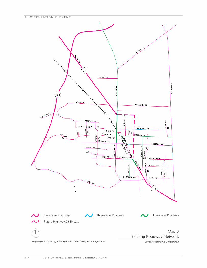
Existing Roadway NetworkThe majority of the roadways within the City of Hollister are two-lane
roadways, with a few three-lane and four-lane segments. Map 8 shows
a schematic diagram of the main streets in the Hollister area and is
color-coded to indicate the number of travel lanes.
These roadways are classified into different functional classifications:
1) highways,
2) major thoroughfares,
3) major collectors,
4) collectors, and
5) residential.
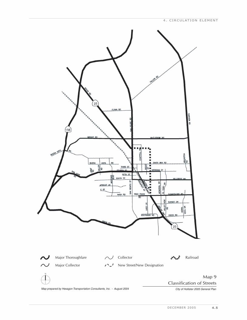
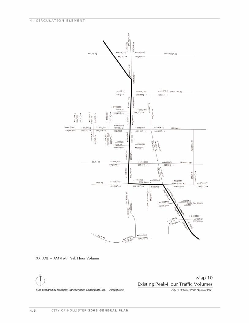
Map 9 illustrates the functional classification of the Hollister area road-
ways and Map 10 shows existing peak-hour traffic volumes on Hollis-
ter's major streets..
The California Department of Transportation (CalTrans) maintains
five state highways in San Benito County (Routes 25, 101, 129, 146,
and 156). Two of these routes, Routes 25 and 156, pass through the
City of Hollister. These are described below.
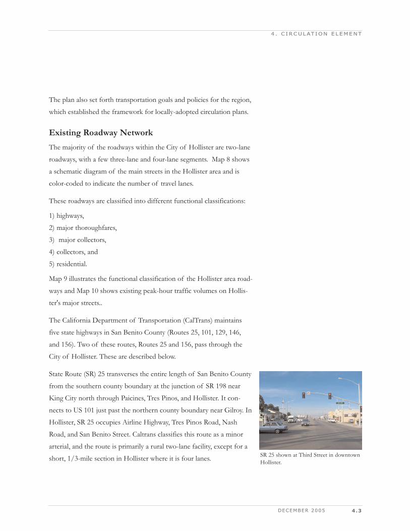
State Route (SR) 25 transverses the entire length of San Benito County
from the southern county boundary at the junction of SR 198 near
King City north through Paicines, Tres Pinos, and Hollister. It con-
nects to US 101 just past the northern county boundary near Gilroy. In
Hollister, SR 25 occupies Airline Highway, Tres Pinos Road, Nash
Road, and San Benito Street. Caltrans classifies this route as a minor
arterial, and the route is primarily a rural two-lane facility, except for a
short, 1/3-mile section in Hollister where it is four lanes.
4 . C IRCULAT ION ELEMENT
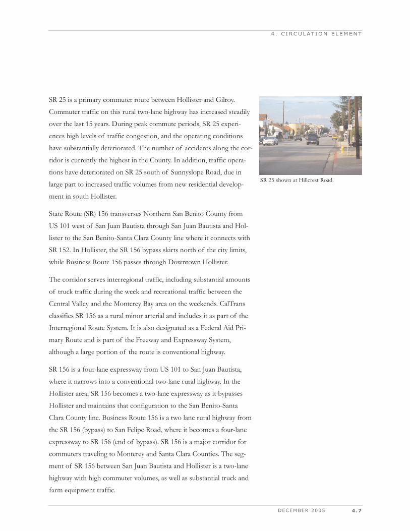
SR 25 shown at Third Street in downtownHollister.
4.4 CITY OF HOLLISTER 2005 GENERAL PLAN
4 . C IRCULAT ION ELEMENT
Map prepared by Hexagon Transportation Consultants, Inc. - August 2004 City of Hollister 2005 General Plan
Map 8Existing Roadway Network
N
Two-Lane Roadway Four-Lane RoadwayThree-Lane Roadway
Future Highway 25 Bypass
DECEMBER 2005 4.5
4 . C IRCULAT ION ELEMENT
Map prepared by Hexagon Transportation Consultants, Inc. - August 2004 City of Hollister 2005 General Plan
Map 9Classification of Streets
N
Major Thoroughfare RailroadCollector
Major Collector New Street/New Designation
4.6 CITY OF HOLLISTER 2005 GENERAL PLAN
4 . C IRCULAT ION ELEMENT
Map prepared by Hexagon Transportation Consultants, Inc. - August 2004 City of Hollister 2005 General Plan
Map 10Existing Peak-Hour Traffic Volumes
N
XX (XX) = AM (PM) Peak Hour Volume
DECEMBER 2005 4.7
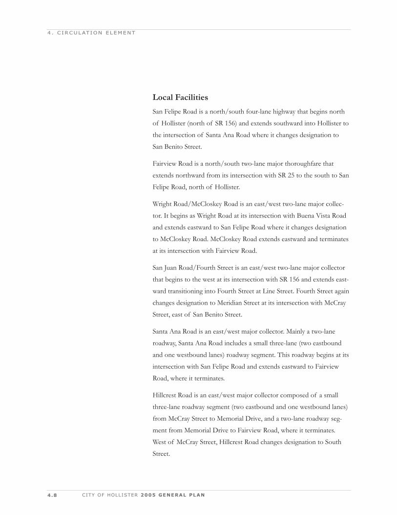
SR 25 is a primary commuter route between Hollister and Gilroy.
Commuter traffic on this rural two-lane highway has increased steadily
over the last 15 years. During peak commute periods, SR 25 experi-
ences high levels of traffic congestion, and the operating conditions
have substantially deteriorated. The number of accidents along the cor-
ridor is currently the highest in the County. In addition, traffic opera-
tions have deteriorated on SR 25 south of Sunnyslope Road, due in
large part to increased traffic volumes from new residential develop-
ment in south Hollister.
State Route (SR) 156 transverses Northern San Benito County from
US 101 west of San Juan Bautista through San Juan Bautista and Hol-
lister to the San Benito-Santa Clara County line where it connects with
SR 152. In Hollister, the SR 156 bypass skirts north of the city limits,
while Business Route 156 passes through Downtown Hollister.
The corridor serves interregional traffic, including substantial amounts
of truck traffic during the week and recreational traffic between the
Central Valley and the Monterey Bay area on the weekends. CalTrans
classifies SR 156 as a rural minor arterial and includes it as part of the
Interregional Route System. It is also designated as a Federal Aid Pri-
mary Route and is part of the Freeway and Expressway System,
although a large portion of the route is conventional highway.
SR 156 is a four-lane expressway from US 101 to San Juan Bautista,
where it narrows into a conventional two-lane rural highway. In the
Hollister area, SR 156 becomes a two-lane expressway as it bypasses
Hollister and maintains that configuration to the San Benito-Santa
Clara County line. Business Route 156 is a two lane rural highway from
the SR 156 (bypass) to San Felipe Road, where it becomes a four-lane
expressway to SR 156 (end of bypass). SR 156 is a major corridor for
commuters traveling to Monterey and Santa Clara Counties. The seg-
ment of SR 156 between San Juan Bautista and Hollister is a two-lane
highway with high commuter volumes, as well as substantial truck and
farm equipment traffic.
4 . C IRCULAT ION ELEMENT
SR 25 shown at Hillcrest Road.
4.8
Local Facilities San Felipe Road is a north/south four-lane highway that begins north
of Hollister (north of SR 156) and extends southward into Hollister to
the intersection of Santa Ana Road where it changes designation to
San Benito Street.
Fairview Road is a north/south two-lane major thoroughfare that
extends northward from its intersection with SR 25 to the south to San
Felipe Road, north of Hollister.
Wright Road/McCloskey Road is an east/west two-lane major collec-
tor. It begins as Wright Road at its intersection with Buena Vista Road
and extends eastward to San Felipe Road where it changes designation
to McCloskey Road. McCloskey Road extends eastward and terminates
at its intersection with Fairview Road.
San Juan Road/Fourth Street is an east/west two-lane major collector
that begins to the west at its intersection with SR 156 and extends east-
ward transitioning into Fourth Street at Line Street. Fourth Street again
changes designation to Meridian Street at its intersection with McCray
Street, east of San Benito Street.
Santa Ana Road is an east/west major collector. Mainly a two-lane
roadway, Santa Ana Road includes a small three-lane (two eastbound
and one westbound lanes) roadway segment. This roadway begins at its
intersection with San Felipe Road and extends eastward to Fairview
Road, where it terminates.
Hillcrest Road is an east/west major collector composed of a small
three-lane roadway segment (two eastbound and one westbound lanes)
from McCray Street to Memorial Drive, and a two-lane roadway seg-
ment from Memorial Drive to Fairview Road, where it terminates.
West of McCray Street, Hillcrest Road changes designation to South
Street.
CITY OF HOLLISTER 2005 GENERAL PLAN
4 . C IRCULAT ION ELEMENT
DECEMBER 2005 4.9
Tres Pinos Road/Sunnyslope Road is an east/west two- to four-lane
major collector that begins at its intersection with Rancho Drive (east
of San Benito Street) as Tres Pinos Road and extends to the east to
Prospect Avenue where it transitions into Sunnyslope Road. Sunnys-
lope Road terminates at its intersection with Fairview Road. West of
Rancho Drive, Tres Pinos Road changes designation to Nash Road.
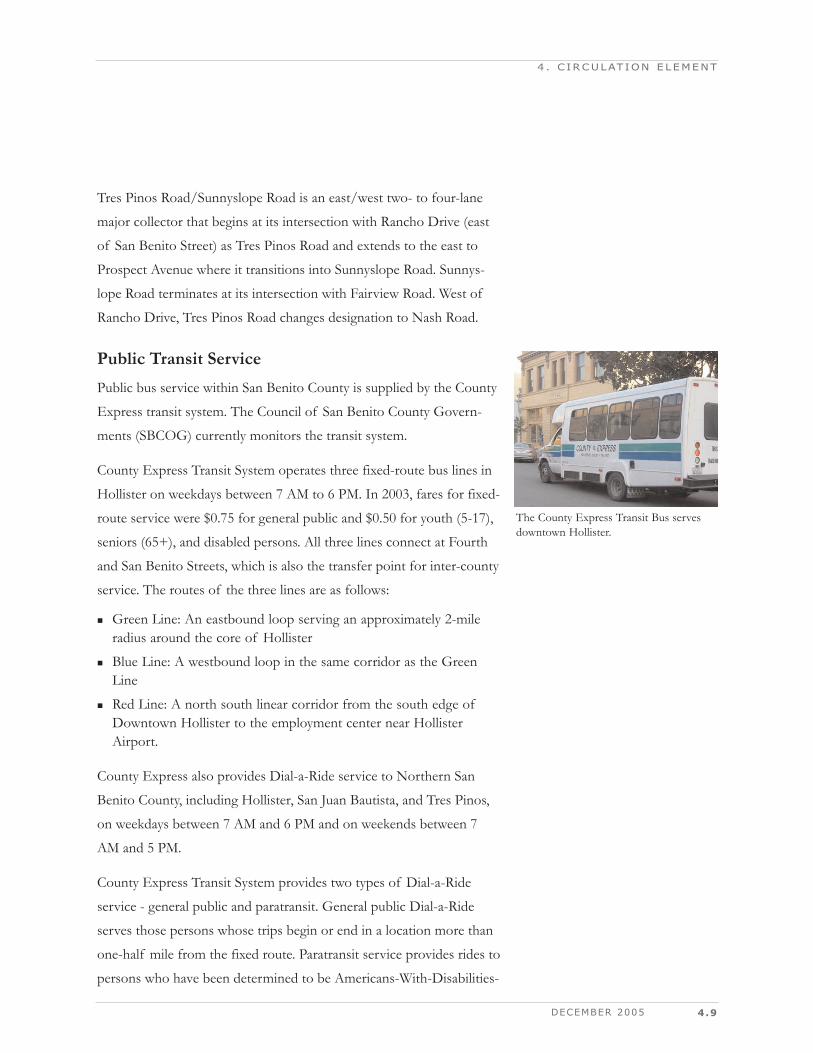
Public Transit ServicePublic bus service within San Benito County is supplied by the County
Express transit system. The Council of San Benito County Govern-
ments (SBCOG) currently monitors the transit system.
County Express Transit System operates three fixed-route bus lines in
Hollister on weekdays between 7 AM to 6 PM. In 2003, fares for fixed-
route service were $0.75 for general public and $0.50 for youth (5-17),
seniors (65+), and disabled persons. All three lines connect at Fourth
and San Benito Streets, which is also the transfer point for inter-county
service. The routes of the three lines are as follows:
Green Line: An eastbound loop serving an approximately 2-mileradius around the core of Hollister
Blue Line: A westbound loop in the same corridor as the GreenLine
Red Line: A north south linear corridor from the south edge ofDowntown Hollister to the employment center near HollisterAirport.
County Express also provides Dial-a-Ride service to Northern San
Benito County, including Hollister, San Juan Bautista, and Tres Pinos,
on weekdays between 7 AM and 6 PM and on weekends between 7
AM and 5 PM.
County Express Transit System provides two types of Dial-a-Ride
service - general public and paratransit. General public Dial-a-Ride
serves those persons whose trips begin or end in a location more than
one-half mile from the fixed route. Paratransit service provides rides to
persons who have been determined to be Americans-With-Disabilities-
4 . C IRCULAT ION ELEMENT
The County Express Transit Bus serves downtown Hollister.
4.10
Act (ADA) eligible through the Local Transit Authority application
process. Appointments for Dial-a-Ride service can be made up to 14
days in advance but no later than 24 hours in advance.
County Express Transit System's inter-county service includes service
to Gilroy's Caltrain station, Gavilan Junior College, and Gilroy's Grey-
hound station. Shuttle service to the Caltrain station and Gavilan
Junior College (school year only) operates Monday through Friday
from 4:30 AM to 8 PM and connects to all trains operating between
Gilroy and San Jose (eight per day). Service to Gilroy's Greyhound sta-
tion operates seven days a week from 7:30 AM to 5 PM. The fare for
all inter-county routes is $1.25 for all patrons, and patrons may pur-
chase a monthly pass for $40.
Commuter Rail ServiceThe nearest connection to commuter rail service is located in Gilroy,
with service to Santa Clara County and points north. SBCOG is evalu-
ating the feasibility of extending Caltrain from Gilroy using the Hollis-
ter Branch Line. In 1999, SBCOG commissioned a study of the
Hollister Branch Rail Line to investigate the cost of branch line
improvements needed for commuter rail operations between Hollister,
San Jose, and San Francisco. In late 1999, the SBCOG continued its
rail development program by commissioning a detailed feasibility
analysis of commuter rail for San Benito County. This study, by R.L.
Banks, was completed at the end of 2000.
Aviation ServicesThe City of Hollister has one public airport, Hollister Municipal Air-
port. Hazel Hawkins Hospital also maintains a heliport at its Hollister
facility.
The Hollister Municipal Airport is located approximately two miles
north of downtown Hollister, adjacent to SR 156. It is owned and
operated by the City of Hollister. The facility is a general aviation air-
CITY OF HOLLISTER 2005 GENERAL PLAN
4 . C IRCULAT ION ELEMENT
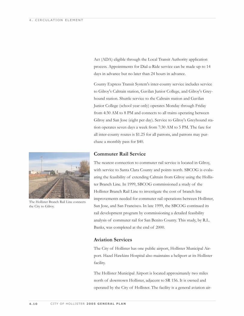
The Hollister Branch Rail Line connectsthe City to Gilroy.
DECEMBER 2005 4.11
port and is included in the National Airport Systems Plan. In its opera-
tional role, it is classed as General Utility and accommodates all current
aviation aircraft except certain business jets. There are 195 aircraft cur-
rently based at the airport with annual operations such as landings and
take-offs estimated at 57,300.
The five-member Hollister Airport Commission oversees the operation
of the facility, and a part-time airport manager manages day-to-day
activities. In 1986, the Hollister City Council adopted the Airport Mas-
ter Plan, which projected use and needed improvements through 2005.
The Airport Master Plan is currently being updated.
Commodity Movement FacilitiesCommodities in San Benito County are transported in and out of San
Benito County by truck and rail, with the large majority of goods being
moved by truck. San Benito County experiences a higher than average
amount of truck traffic, and this activity, while largely confined to state
highways, impacts local streets and rural roads not designed to handle
large, heavy trucks. The sole rail line in San Benito County is the 12-
mile-long Hollister Branch Line running from Hollister to Carnadero
in Santa Clara County. The facility is owned by the Union Pacific Rail-
road.
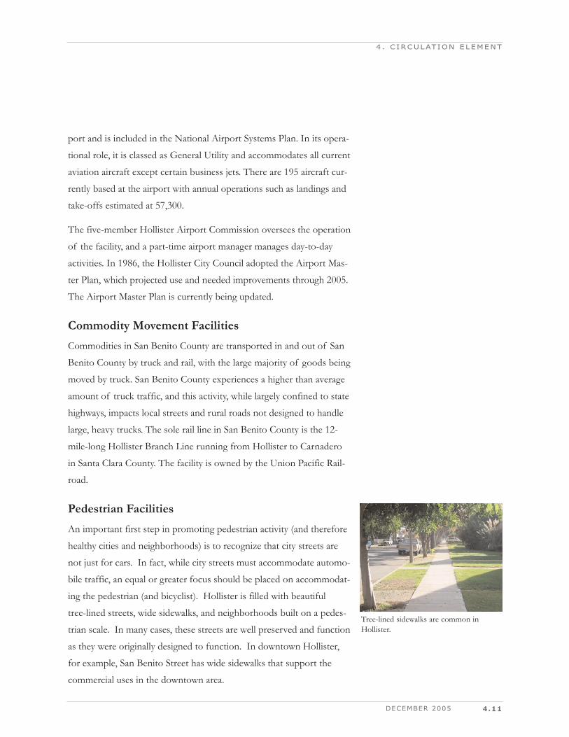
Pedestrian FacilitiesAn important first step in promoting pedestrian activity (and therefore
healthy cities and neighborhoods) is to recognize that city streets are
not just for cars. In fact, while city streets must accommodate automo-
bile traffic, an equal or greater focus should be placed on accommodat-
ing the pedestrian (and bicyclist). Hollister is filled with beautiful
tree-lined streets, wide sidewalks, and neighborhoods built on a pedes-
trian scale. In many cases, these streets are well preserved and function
as they were originally designed to function. In downtown Hollister,
for example, San Benito Street has wide sidewalks that support the
commercial uses in the downtown area.
4 . C IRCULAT ION ELEMENT
Tree-lined sidewalks are common inHollister.
4.12 CITY OF HOLLISTER 2005 GENERAL PLAN
4 . C IRCULAT ION ELEMENT
Bicycle FacilitiesThere are currently limited bicycle facilities in Hollister. Most bicycling
is done on roadway shoulders, which are not striped for bike lanes. In
many cases, bicycles can be accommodated on well-designed streets
without the need for separate bike lanes. However, as many of the
major city streets in Hollister become impacted by heavy traffic,
increased emphasis must be placed on accommodating bicycle travel
when designing streets. This can be accomplished by adding Class II
bicycle lanes on existing streets and by providing alternative routes
dedicated to bicycle and pedestrian use (Class I facilities).
At present, there are two Class I bicycle facilities in the Hollister Area.
One of these is adjacent to Prospect Avenue/Airline Highway,
between Hawkins Street and Sunset Drive; the other is adjacent to
State Route 25, from Tres Pinos School to Southside Road.
In 2001, the SBCOG adopted a revised County Bikeway Plan, which
designates routes that can be used by commuters, recreational riders,
students, and others for safe, convenient access to major employers,
shopping centers, and schools throughout Hollister.
DECEMBER 2005 4.13
4 . C IRCULAT ION ELEMENT
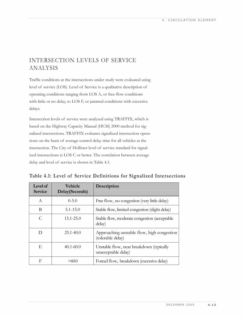
INTERSECTION LEVELS OF SERVICEANALYSIS
Traffic conditions at the intersections under study were evaluated using
level of service (LOS). Level of Service is a qualitative description of
operating conditions ranging from LOS A, or free-flow conditions
with little or no delay, to LOS F, or jammed conditions with excessive
delays.
Intersection levels of service were analyzed using TRAFFIX, which is
based on the Highway Capacity Manual (HCM) 2000 method for sig-
nalized intersections. TRAFFIX evaluates signalized intersection opera-
tions on the basis of average control delay time for all vehicles at the
intersection. The City of Hollister level of service standard for signal-
ized intersections is LOS C or better. The correlation between average
delay and level of service is shown in Table 4.1.
Table 4.1: Level of Service Definitions for Signalized Intersections
Level of Service
Vehicle Delay(Seconds)
Description
A 0-5.0 Free flow, no congestion (very little delay)
B 5.1-15.0 Stable flow, limited congestion (slight delay)
C 15.1-25.0 Stable flow, moderate congestion (acceptable delay)
D 25.1-40.0 Approaching unstable flow, high congestion (tolerable delay)
E 40.1-60.0 Unstable flow, near breakdown (typically unacceptable delay)
F >60.0 Forced flow, breakdown (excessive delay)
4.14 CITY OF HOLLISTER 2005 GENERAL PLAN
4 . C IRCULAT ION ELEMENT
Existing Traffic ConditionsExisting peak hour traffic volumes were obtained from recent manual
turning-movement counts at the key study intersections. The existing
lane configurations at the study intersections were obtained from field
observations.
Existing Intersection Levels of ServiceIt is the intent of this plan that most streets should operate with no
more than a tolerable level of congestion, LOS C. The concept of
maintaining no worse than a tolerable level of congestion is important,
not only to provide a reasonable LOS for motorists, but also to protect
neighborhoods from the impact of excessive through traffic. To the
extent that the arterial and major collector street system is operating
with limited congestion, there will be less incentive for drivers to use
local streets to bypass areas of congestion
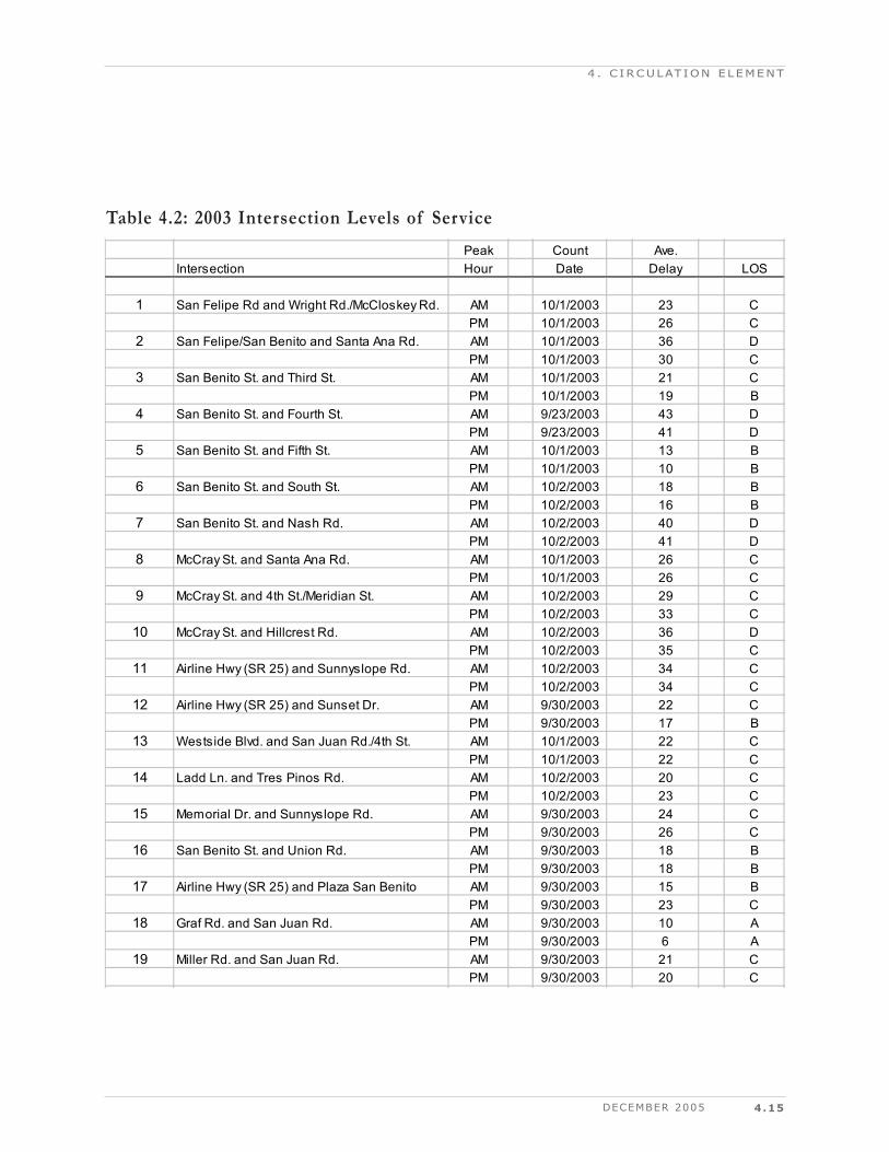
The results of the level of service analysis under existing conditions
are summarized in Table 4.2. The results show that four of the study
intersections currently operate at an unacceptable LOS D during at
least one of the peak hours.
San Felipe/San Benito and Santa Ana Road
San Benito Street and Fourth Street
San Benito Street and Nash Road
McCray Street and Hillcrest Road
All other study intersections were found to operate at LOS C or better.
The level of service results under existing conditions are summarized
on Map 11.
DECEMBER 2005 4.15
4 . C IRCULAT ION ELEMENT
Peak Count Ave.Intersection Hour Date Delay LOS
1 San Felipe Rd and Wright Rd./McCloskey Rd. AM 10/1/2003 23 CPM 10/1/2003 26 C
2 San Felipe/San Benito and Santa Ana Rd. AM 10/1/2003 36 DPM 10/1/2003 30 C
3 San Benito St. and Third St. AM 10/1/2003 21 CPM 10/1/2003 19 B
4 San Benito St. and Fourth St. AM 9/23/2003 43 DPM 9/23/2003 41 D
5 San Benito St. and Fifth St. AM 10/1/2003 13 BPM 10/1/2003 10 B
6 San Benito St. and South St. AM 10/2/2003 18 BPM 10/2/2003 16 B
7 San Benito St. and Nash Rd. AM 10/2/2003 40 DPM 10/2/2003 41 D
8 McCray St. and Santa Ana Rd. AM 10/1/2003 26 CPM 10/1/2003 26 C
9 McCray St. and 4th St./Meridian St. AM 10/2/2003 29 CPM 10/2/2003 33 C
10 McCray St. and Hillcrest Rd. AM 10/2/2003 36 DPM 10/2/2003 35 C
11 Airline Hwy (SR 25) and Sunnyslope Rd. AM 10/2/2003 34 CPM 10/2/2003 34 C
12 Airline Hwy (SR 25) and Sunset Dr. AM 9/30/2003 22 CPM 9/30/2003 17 B
13 Westside Blvd. and San Juan Rd./4th St. AM 10/1/2003 22 CPM 10/1/2003 22 C
14 Ladd Ln. and Tres Pinos Rd. AM 10/2/2003 20 CPM 10/2/2003 23 C
15 Memorial Dr. and Sunnyslope Rd. AM 9/30/2003 24 CPM 9/30/2003 26 C
16 San Benito St. and Union Rd. AM 9/30/2003 18 BPM 9/30/2003 18 B
17 Airline Hwy (SR 25) and Plaza San Benito AM 9/30/2003 15 BPM 9/30/2003 23 C
18 Graf Rd. and San Juan Rd. AM 9/30/2003 10 APM 9/30/2003 6 A
19 Miller Rd. and San Juan Rd. AM 9/30/2003 21 CPM 9/30/2003 20 C
Table 4.2: 2003 Intersection Levels of Service
4.16 CITY OF HOLLISTER 2005 GENERAL PLAN
4 . C IRCULAT ION ELEMENT
Map prepared by Hexagon Transportation Consultants, Inc. - August 2004 City of Hollister 2005 General Plan
Map 112003 Intersection Levels of Service
N
2000 Highway Capacity Manual (HCM)Level of Service Methodology Used
PMPMAMAM
Note:
Levels of Service
DECEMBER 2005 4.17
KEY FINDINGS AND RECOMMENDATIONS
Forecasts of future demand on the City's transportation system were
prepared using the San Benito County/Hollister travel demand model.
This model uses widely accepted transportation planning formulas to
convert forecasts of future land use into the number and distribution
of future vehicle trips on the roadway network. The forecast volumes
are compared to the roadway design capacities to identify transporta-
tion corridors, roadway segments, or intersections where a prescribed
level of service will be exceeded.
Various roadway improvements have been identified and assumed in
place in the year 2023. These improvements are designed to maintain
or improve the current levels of service for the roadways and meet
future traffic demand within the City of Hollister and the San Benito
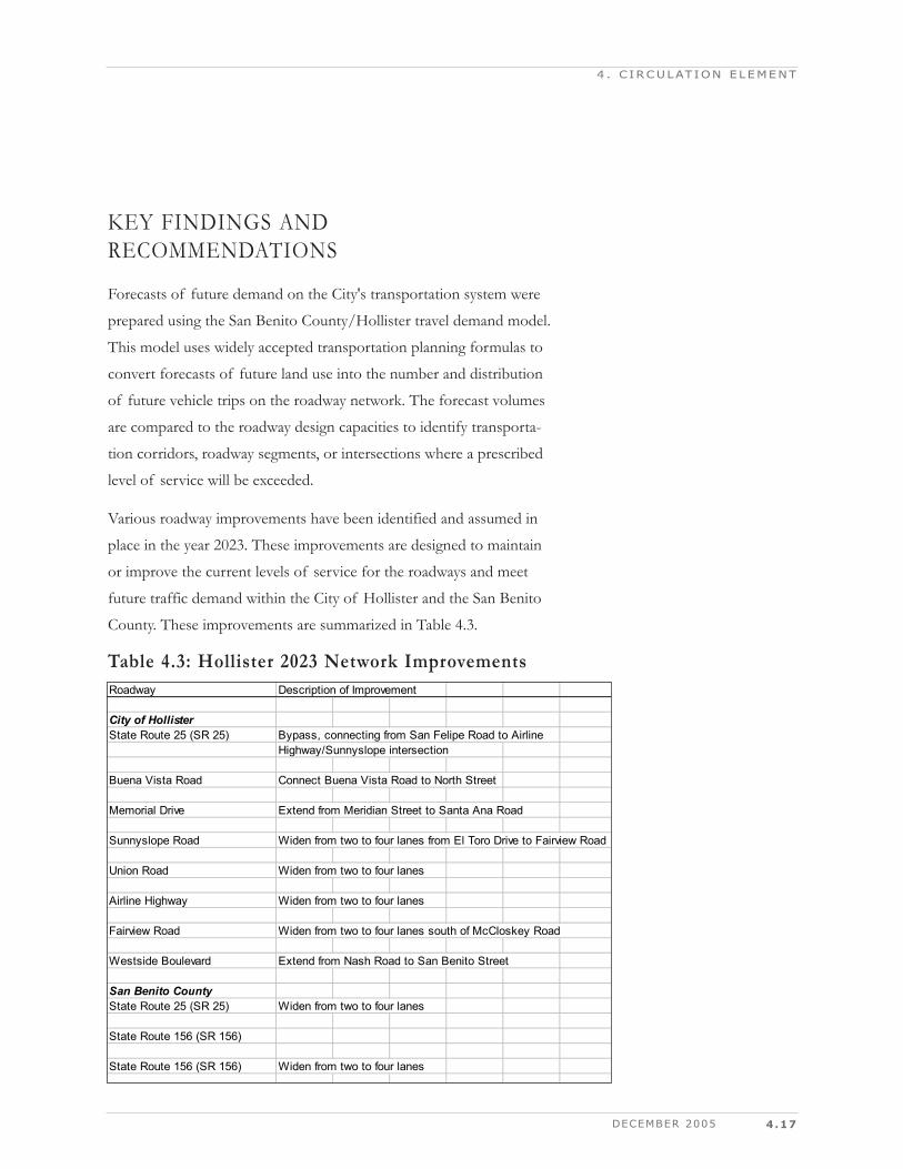
County. These improvements are summarized in Table 4.3.
4 . C IRCULAT ION ELEMENT
Roadway Description of Improvement
City of HollisterState Route 25 (SR 25) Bypass, connecting from San Felipe Road to Airline
Highway/Sunnyslope intersection
Buena Vista Road Connect Buena Vista Road to North Street
Memorial Drive Extend from Meridian Street to Santa Ana Road
Sunnyslope Road Widen from two to four lanes from El Toro Drive to Fairview Road
Union Road Widen from two to four lanes
Airline Highway Widen from two to four lanes
Fairview Road Widen from two to four lanes south of McCloskey Road
Westside Boulevard Extend from Nash Road to San Benito Street
San Benito CountyState Route 25 (SR 25) Widen from two to four lanes
State Route 156 (SR 156)
State Route 156 (SR 156) Widen from two to four lanes
Table 4.3: Hollister 2023 Network Improvements
The network improvements that are included are based on information
from several recent planning efforts. These include the 1995 General
Plan, the 2001 San Benito County Regional Transportation Plan and
the planning associated with the traffic impact fee programs for Hollis-
ter, San Juan Bautista and San Benito County. One of the common
characteristics of all these previous planning efforts was that they
relied upon a planning horizon of approximately 10 years.
A variety of factors led to the decision to set the year 2023 as the long-
range planning horizon for this update of the Hollister General Plan.
Therefore, a set of population, housing and employment projections
were developed based on the land use designations shown on the draft
Hollister General Plan Map, and other state and regional projections of
population and employment growth. The constrained projections
adopted by the Association of Monterey Bay Area Governments
(AMBAG) were used as the controlling values for the Hollister 2023
growth projections.
These projections were then allocated to the traffic analysis zones used
by the City's traffic forecasting model. The traffic forecasting model
was then used to develop projections of future traffic demand on the
area's roadway system. The results were then analyzed to determine
where there were projected roadway capacity deficiencies, and to
develop recommendations for further improvements.
4.18 CITY OF HOLLISTER 2005 GENERAL PLAN
4 . C IRCULAT ION ELEMENT
DECEMBER 2005 4.19
4 . C IRCULAT ION ELEMENT
Hollister Growth AreasThe draft General Plan includes a Phasing Diagram that indicates the
City's priorities for locating future residential growth. The General Plan
also includes a similar diagram showing the preferred locations for
retail growth. These diagrams and their associated growth allocations
were the basis for developing the 2023 projected distribution of popu-
lation and employment.
The phasing diagram designates a large number of infill sites as the
first priority for future residential growth. Subsequent phases provide
for new residential areas outside of, but contiguous to, the existing
urbanized area. These new residential areas include land northeast,
south, east, and eventually northwest of the City respectively as the
preferred progression of development. New employment growth is
focused within the existing downtown, new retail gateways north and
west of the downtown, and in the industrial park near the airport.
A total of about 7,200 new residential units were included in the above
described residential areas. Employment growth of approximately
7,800 was also included. This amount of household and employment
growth is projected to occur between 2004 and 2023.
4.20 CITY OF HOLLISTER 2005 GENERAL PLAN
4 . C IRCULAT ION ELEMENT
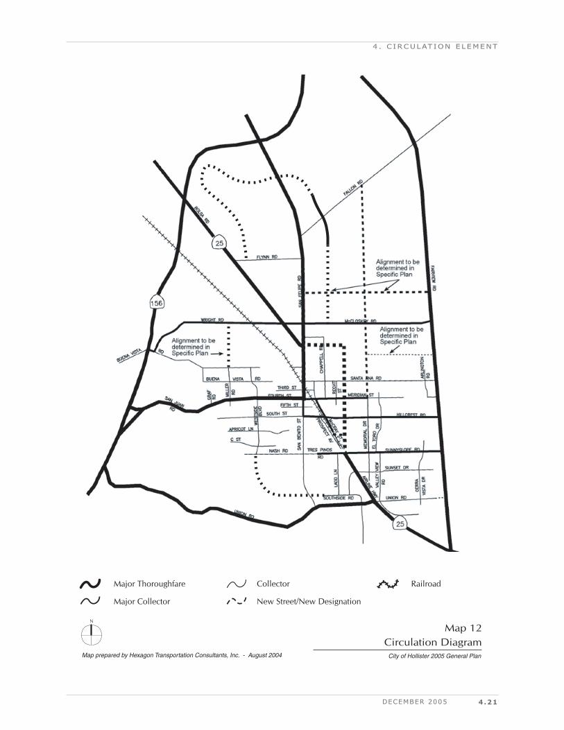
Planned Circulation ImprovementsThis section sets forth Hollister's Circulation Diagram and describes
each major circulation improvement project planned over the 20-year
planning horizon.
Circulation DiagramThe Circulation Diagram is intended to be the definitive source for
future changes in Hollister's circulation system. The intended effect of
this diagram and the street classifications show therein is to govern the
growth and character of major circulation facilities, including street
and railroad facilities. The street classifications used in this diagram are
described in the following section, and streets in all classifications are
intended to be influenced by their land use context.
Map 12 shows the Hollister General Plan Circulation Diagram.
DECEMBER 2005 4.21
4 . C IRCULAT ION ELEMENT
Map prepared by Hexagon Transportation Consultants, Inc. - August 2004 City of Hollister 2005 General Plan
Map 12Circulation Diagram
N
Major Thoroughfare RailroadCollector
Major Collector New Street/New Designation
4.22
Street Classification and DesignThis section sets forth the street classifications used in the Circulation
Diagram to designate how streets will be developed during the 20-year
planning horizon of this plan.
The street classifications set forth in this Circulation Element combine
traditional street classifications, which define design and operational
characteristics based on the need to accommodate the movement of
motor vehicles, with context-sensitive street classifications, which fac-
tor in neighboring land uses and the need to accommodate pedestrians,
bicyclists, and transit users. The resulting matrix of street classifica-
tions creates a framework within which street design is influenced by
both function and context.
Table 4.4 shows the relationship between street classifications and land
use.
CITY OF HOLLISTER 2005 GENERAL PLAN
4 . C IRCULAT ION ELEMENT
Function/ Design Context
Major Thoroughfare
Street
Major Collector
Street Collector
Street Residential
Street Commercial Use X X – –
Main Street Use – X X –
Mixed Use X X X X
Residential Use – X X X
Industrial Use X X X X
Table 4.4: Street Classification and LandUse Context
DECEMBER 2005 4.23
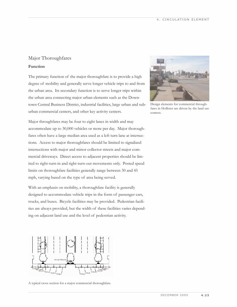
Major ThoroughfaresFunction
The primary function of the major thoroughfare is to provide a high
degree of mobility and generally serve longer vehicle trips to and from
the urban area. Its secondary function is to serve longer trips within
the urban area connecting major urban elements such as the Down-
town Central Business District, industrial facilities, large urban and sub-
urban commercial centers, and other key activity centers.
Major throughfares may be four to eight lanes in width and may
accommodate up to 30,000 vehicles or more per day. Major thorough-
fares often have a large median area used as a left turn lane at intersec-
tions. Access to major thoroughfares should be limited to signalized
intersections with major and minor collector streets and major com-
mercial driveways. Direct access to adjacent properties should be lim-
ited to right-turn-in and right-turn-out movements only. Posted speed
limits on thoroughfare facilities generally range between 30 and 45
mph, varying based on the type of area being served.
With an emphasis on mobility, a thoroughfare facility is generally
designed to accommodate vehicle trips in the form of passenger cars,
trucks, and buses. Bicycle facilities may be provided. Pedestrian facili-
ties are always provided, but the width of these facilities varies depend-
ing on adjacent land use and the level of pedestrian activity.
4 . C IRCULAT ION ELEMENT
A typical cross section for a major commercial thoroughfare.
Design elements for commercial through-fares in Hollister are driven by the land use context.
4.24
Design Context
As with all functional street types, the design of a major throughfare
depends on its land use context. Traffic-dependent commercial land
uses, such as suburban shopping centers, are the most common land
use along major arterials. Where this is the case, for example Airline
Highway, primary design considerations are lane width and access man-
agement.
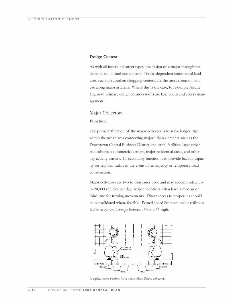
Major CollectorsFunction
The primary function of the major collector is to serve longer trips
within the urban area connecting major urban elements such as the
Downtown Central Business District, industrial facilities, large urban
and suburban commercial centers, major residential areas, and other
key activity centers. Its secondary function is to provide backup capac-
ity for regional traffic in the event of emergency or temporary road
construction.
Major collectors are two to four lanes wide and may accommodate up
to 20,000 vehicles per day. Major collectors often have a median or
third lane for turning movements. Direct access to properties should
be consolidated where feasible. Posted speed limits on major collector
facilities generally range between 30 and 35 mph.
CITY OF HOLLISTER 2005 GENERAL PLAN
4 . C IRCULAT ION ELEMENT
A typical cross section for a major Main Street collector.
DECEMBER 2005 4.25
Design Context
A mix of land uses, such as office and residential, is the most common
land use along major collectors. Where this is the case, for example on
San Benito Street south of South Street, high priority design elements
include wide sidewalks and transit facilities with high amenities. Alter-
natively, in a Main Street context with limited right-of-way, for example
Fourth Street, lane width and access management may be compro-
mised in favor of wide sidewalks, planting strips that separate the side-
walk from the street, and on-street parking.
CollectorsFunction
The primary function of a collector is to provide access between local
streets and arterials. Its secondary function is to provide access to land
within residential, commercial, and industrial areas.
Collectors are two lanes wide and may accommodate up to 10,000
vehicles per day. Direct access to adjacent properties is discouraged.
Speed limits are typically in the 25-to-35 miles per hour range.
4 . C IRCULAT ION ELEMENT
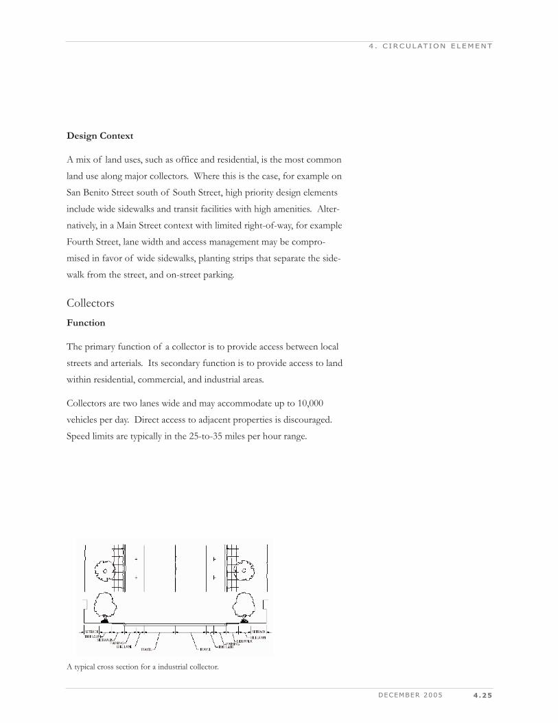
A typical cross section for a industrial collector.
4.26
Design Context
Residential or industrial land uses are the most common land use along
collector streets. In residential areas, collector streets provide access to
local residential streets and occasionally provide direct access to resi-
dential properties. Where this is the case, for example on Buena Vista
Road, high priority design elements include detached sidewalks and
street trees in planting strips. Alternatively, in an industrial context, for
example on Chappell Road, emphasis shifts to lane width and intersec-
tion design for large trucks.
Residential StreetsFunction
The primary function of a residential street is to provide direct access
from collector streets to residential, industrial, and mixed-use property.
In the residential and mixed-use contexts, the primary function of the
residential street is also to provide a high amenity environment for
pedestrians. Its secondary function is to provide access to alternative
collectors in high traffic periods. Mobility on local streets is typically
incidental and involves relatively short trips at lower speeds to and
from collector facilities.
Because of their "neighborhood" nature, travel speeds are generally
lower than collectors and throughfares. Posted speed limits on residen-
tial streets generally range between 25 and 30 mph, depending on avail-
able right-of-way and the adjacent land uses. Traffic volumes on local
streets are generally less than 5,000 vehicles per day, and also vary
depending on available right-of-way and the adjacent land uses.
Pedestrian and bicycle safety and aesthetics are generally high priorities
on local streets in residential and commercial areas. Wider travel lanes
and broader turning radii to accommodate larger vehicle size are major
considerations on residential streets in industrial areas.
CITY OF HOLLISTER 2005 GENERAL PLAN
4 . C IRCULAT ION ELEMENT
DECEMBER 2005 4.27
Design Context
Residential and mixed land uses are the most common land uses along
residential streets. In residential areas, high priority design elements
include detached sidewalks, street trees in planting strips, and on-street
parking. In mixed-use areas, high priority design elements include wide
sidewalks with transit access, bicycle lanes on designated bike routes,
and on-street parking.
4 . C IRCULAT ION ELEMENT
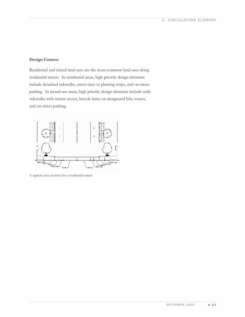
A typical cross section for a residential street.
4.28
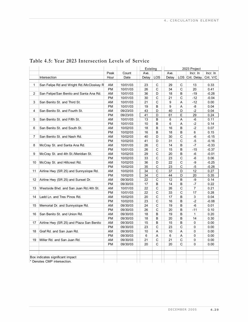
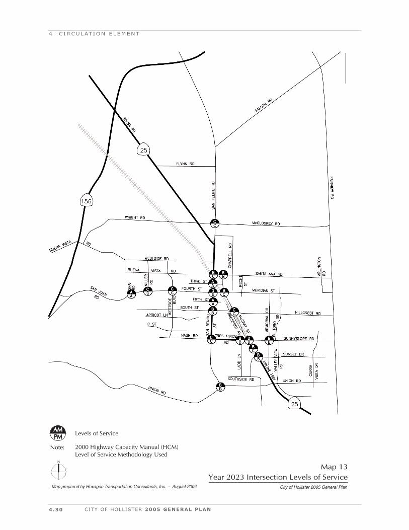
Year 2023 Intersection Levels of ServiceThe results of the level of service analysis under Year 2023 conditions
are summarized in Table 4.5. The results show that two of the study
intersections would operate at an unacceptable LOS D and E during at
least one of the peak hours under year 2023 conditions:
San Benito Street and Fourth Street (LOS E), and
Airline Highway (SR 25) and Sunnyslope Road (LOS D)
All other study intersections would operate at LOS C or better. The
level of service results under year 2023 conditions are summarized on
Map 13.
Roadway Capacity Deficiency AnalysisRoadway capacity deficiencies were identified in several areas. These
deficiencies are directly related to the future land use designations
shown on the updated General Plan Land Use Plan. The deficiencies
can be grouped into several categories of roadway capacity needs.
These include:
Regional commuting,
Northwest Hollister circulation needs,
Southeast Hollister circulation needs, and
Additional roadway capacity serving the Industrial Park.
Regional Commuting DeficienciesThe household and employment projections through the year 2023
show a reasonable balance between new housing and new jobs. The
projected household growth was about 7,200 residential units and the
projected employment growth was about 7,800. However, since most
households tend to have more than one worker, each new residential
unit can be expected to contribute to the demand for inter-regional
commuting. Consequently, the travel forecasts show projected roadway
capacity deficiencies for the major highways and arterial streets serving
regional commuters.
CITY OF HOLLISTER 2005 GENERAL PLAN
4 . C IRCULAT ION ELEMENT
DECEMBER 2005 4.29
4 . C IRCULAT ION ELEMENT
ExistingPeak Count Ave. Ave. Incr. In Incr. In
Intersection Hour Date Delay LOS Delay LOS Crit. Delay. Crit. V/C
1 San Felipe Rd and Wright Rd./McCloskey R AM 10/01/03 23 C 29 C 13 0.33PM 10/01/03 26 C 34 C 20 0.41
2 San Felipe/San Benito and Santa Ana Rd. AM 10/01/03 36 D 18 B -19 -0.28PM 10/01/03 30 C 21 C -12 -0.04
3 San Benito St. and Third St. AM 10/01/03 21 C 9 A -12 0.00PM 10/01/03 19 B 9 A -8 0.04
4 San Benito St. and Fourth St. AM 09/23/03 43 D 40 D -2 0.04PM 09/23/03 41 D 61 E 29 0.24
5 San Benito St. and Fifth St. AM 10/01/03 13 B 6 A -6 0.11PM 10/01/03 10 B 6 A -2 0.14
6 San Benito St. and South St. AM 10/02/03 18 B 16 B -2 0.07PM 10/02/03 16 B 18 B 6 0.15
7 San Benito St. and Nash Rd. AM 10/02/03 40 D 30 C -6 -0.15PM 10/02/03 41 D 31 C -5 -0.16
8 McCray St. and Santa Ana Rd. AM 10/01/03 26 C 14 B -7 -0.33PM 10/01/03 26 C 15 B -15 -0.37
9 McCray St. and 4th St./Meridian St. AM 10/02/03 29 C 20 B -6 -0.01PM 10/02/03 33 C 23 C -6 0.06
10 McCray St. and Hillcrest Rd. AM 10/02/03 36 D 22 C -9 -0.25PM 10/02/03 35 C 23 C -5 -0.28
11 Airline Hwy (SR 25) and Sunnyslope Rd. AM 10/02/03 34 C 37 D 12 0.27PM 10/02/03 34 C 44 D 20 0.35
12 Airline Hwy (SR 25) and Sunset Dr. AM 09/30/03 22 C 12 B -9 0.14PM 09/30/03 17 B 14 B -7 0.22
13 Westside Blvd. and San Juan Rd./4th St. AM 10/01/03 22 C 26 C 7 0.21PM 10/01/03 22 C 33 C 17 0.28
14 Ladd Ln. and Tres Pinos Rd. AM 10/02/03 20 C 17 B 3 0.04PM 10/02/03 23 C 16 B -2 -0.08
15 Memorial Dr. and Sunnyslope Rd. AM 09/30/03 24 C 19 B -6 0.01PM 09/30/03 26 C 20 B -11 0.10
16 San Benito St. and Union Rd. AM 09/30/03 18 B 19 B 1 0.20PM 09/30/03 18 B 20 B 14 0.30
17 Airline Hwy (SR 25) and Plaza San Benito AM 09/30/03 15 B 15 B 0 0.00PM 09/30/03 23 C 23 C 0 0.00
18 Graf Rd. and San Juan Rd. AM 09/30/03 10 A 10 A 0 0.00PM 09/30/03 6 A 6 A 0 0.00
19 Miller Rd. and San Juan Rd. AM 09/30/03 21 C 21 C 0 0.00PM 09/30/03 20 C 20 C 0 0.00
Box indicates significant impact* Denotes CMP intersection.
2023 Project
Table 4.5: Year 2023 Intersection Levels of Service
4.30 CITY OF HOLLISTER 2005 GENERAL PLAN
4 . C IRCULAT ION ELEMENT
Map prepared by Hexagon Transportation Consultants, Inc. - August 2004 City of Hollister 2005 General Plan
Map 13Year 2023 Intersection Levels of Service
N
2000 Highway Capacity Manual (HCM)Level of Service Methodology Used
PMPMAMAM
Note:
Levels of Service
DECEMBER 2005 4.31
Capacity deficiencies were identified along the two major State High-
ways 25 and 156, and along Fairview and Shore Roads. The
Fairview/Shore Road route is frequently used by commuters who are
avoiding the high traffic volumes on Highway 25 between Hollister and
Route 101 and Highway 152 between Gilroy and the intersection with
Highway 156.
Circulation Needs In Northwest HollisterThe updated General Plan includes new residential and gateway com-
mercial designations for the northwest area of Hollister. The new des-
ignations cover not only the areas near and between Fourth Street and
Buena Vista Road, but also the land between Buena Vista Road and
Wright Road. The area is large enough to eventually support more than
2,000 new residential units.
Capacity deficiencies were identified on Wright Road, Buena Vista
Road, and Fourth Street.
Circulation Needs in Southeast HollisterThe circulation needs for the southeast area of Hollister have been
previously studied and the 2023 traffic forecasts reinforce the earlier
conclusions regarding needed roadway improvements. Union Road and
Airline Highway will eventually require widening to four or more lanes.
Additional Roadway Capacity Serving the IndustrialParkFallon Road is the major thoroughfare leading in to Hollister's indus-
trial park near the municipal airport. The industrial park has the largest
amount of land available for employment growth in the area. It is pro-
jected that about 25 percent of the non-retail employment growth will
likely occur at the industrial park. The segment of Fallon Road just east
of its intersection with San Felipe Road is projected to have a capacity
deficiency by the year 2023. Fallon Road should be widened to 4 lanes
through the industrial park.
4 . C IRCULAT ION ELEMENT
4.32
CIRCULATION ELEMENT GOALS ANDPOLICIES
The matrix presented on the following pages is intended to guide
implementation of the City's Circulation element. In addition to iden-
tifying a timeline for implementation in the matrix, each lettered item is
described in detail in the "Implementation Measures" section that
immediately follows. The matrix is organized according to the follow-
ing circulation goals:
CITY OF HOLLISTER 2005 GENERAL PLAN
4 . C IRCULAT ION ELEMENT
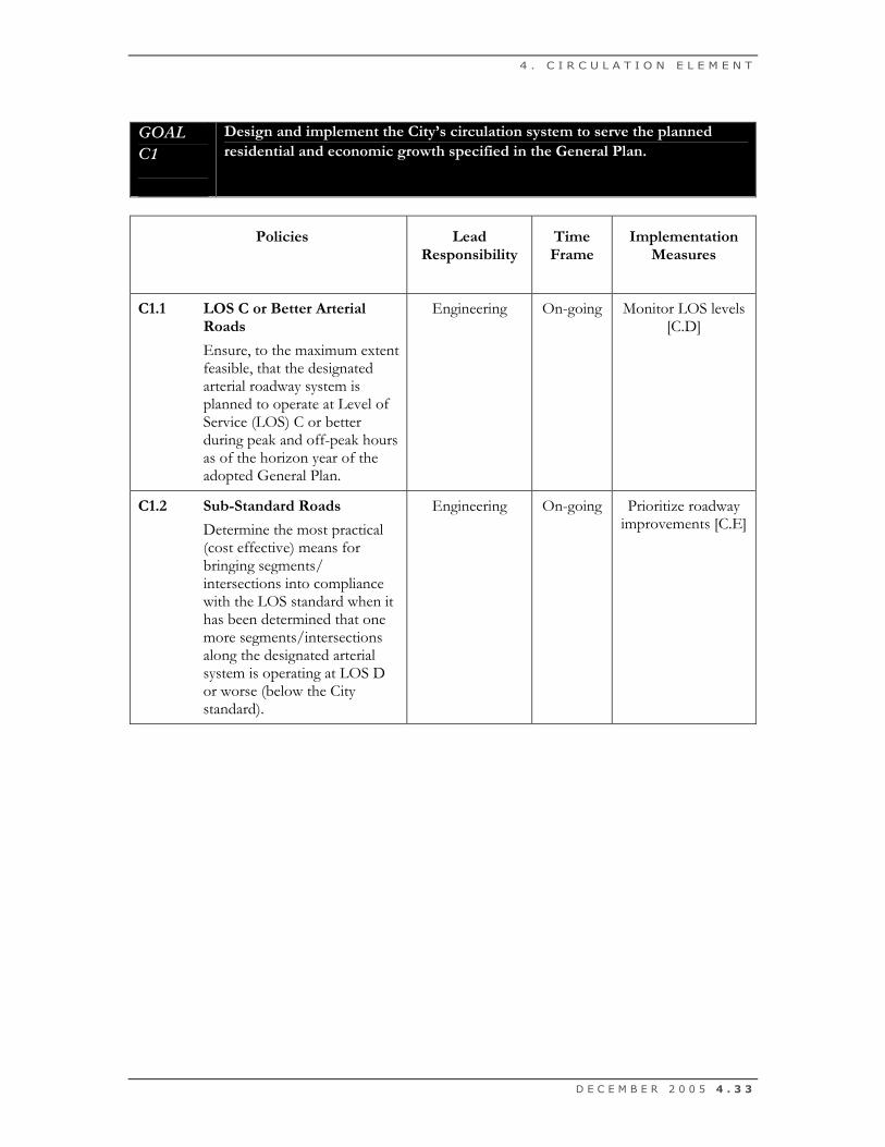
GOAL C1 Design and implement the City’s circulation system to serve the planned residential and economic growth specified in the General Plan.
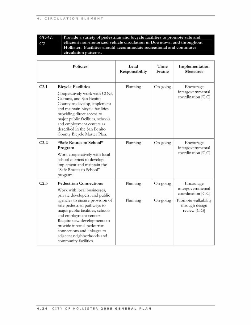
GOAL C2 Provide a variety of pedestrian and bicycle facilities to promote safe and efficient non-motorized vehicle circulation in Downtown and throughout Hollister. Facilities should accommodate recreational and commuter circulation patterns.
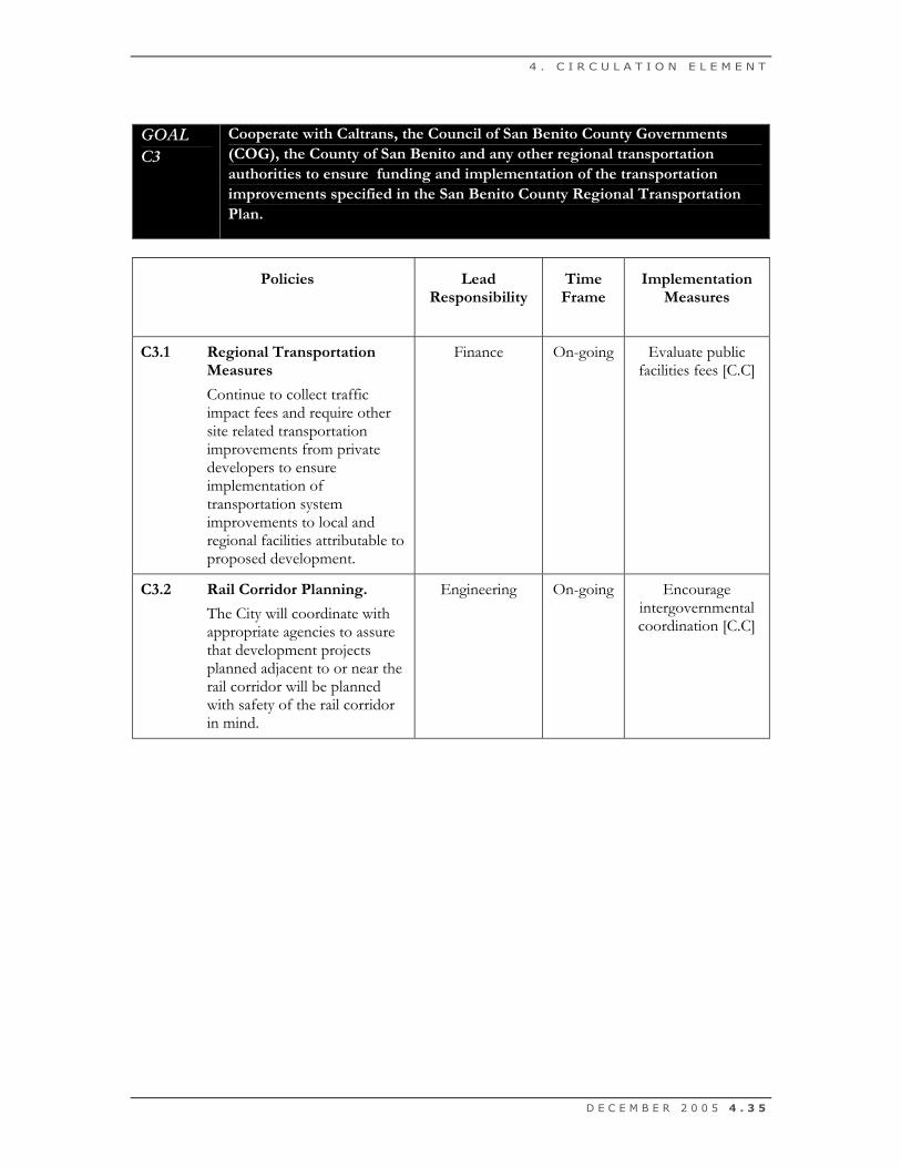
GOAL C3 Cooperate with Caltrans, the Council of San Benito County Governments (COG), the County of San Benito and any other regional transportation authorities to ensure the funding and implementation of the transportation improvements specified in the San Benito County Regional Transportation Plan.
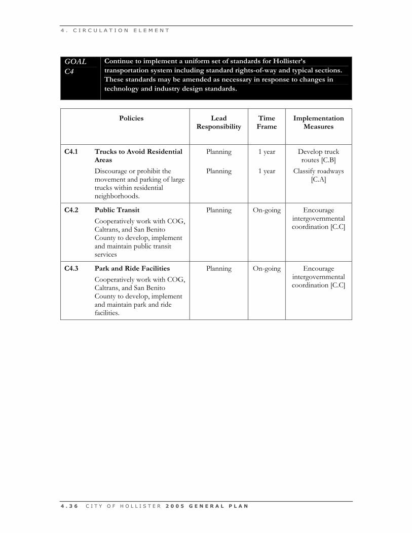
GOAL C4 Continue to implement a uniform set of standards for Hollister’s transportation system including standard rights-of-way and typical sections. These standards may be amended as necessary in response to changes in technology and industry design standards.
4 . C I R C U L A T I O N E L E M E N T
D E C E M B E R 2 0 0 5 4 . 3 3
GOAL C1
Design and implement the City’s circulation system to serve the planned residential and economic growth specified in the General Plan.
Policies
Lead Responsibility
Time Frame
Implementation Measures
C1.1 LOS C or Better Arterial
Roads
Ensure, to the maximum extent feasible, that the designated arterial roadway system is planned to operate at Level of Service (LOS) C or better during peak and off-peak hours as of the horizon year of the adopted General Plan.
Engineering On-going Monitor LOS levels [C.D]
C1.2 Sub-Standard Roads
Determine the most practical (cost effective) means for bringing segments/ intersections into compliance with the LOS standard when it has been determined that one more segments/intersections along the designated arterial system is operating at LOS D or worse (below the City standard).
Engineering
On-going
Prioritize roadway improvements [C.E]
4 . C I R C U L A T I O N E L E M E N T
4 . 3 4 C I T Y O F H O L L I S T E R 2 0 0 5 G E N E R A L P L A N
GOAL C2
Provide a variety of pedestrian and bicycle facilities to promote safe and efficient non-motorized vehicle circulation in Downtown and throughout Hollister. Facilities should accommodate recreational and commuter circulation patterns.
Policies
Lead Responsibility
Time Frame
Implementation Measures
C2.1 Bicycle Facilities
Cooperatively work with COG, Caltrans, and San Benito County to develop, implement and maintain bicycle facilities providing direct access to major public facilities, schools and employment centers as described in the San Benito County Bicycle Master Plan.
Planning
On-going
Encourage intergovernmental coordination [C.C]
C2.2 “Safe Routes to School” Program
Work cooperatively with local school districts to develop, implement and maintain the "Safe Routes to School" program.
Planning
On-going
Encourage intergovernmental coordination [C.C]
C2.3 Pedestrian Connections
Work with local businesses, private developers, and public agencies to ensure provision of safe pedestrian pathways to major public facilities, schools and employment centers. Require new developments to provide internal pedestrian connections and linkages to adjacent neighborhoods and community facilities.
Planning
Planning
On-going
On-going
Encourage intergovernmental coordination [C.C] Promote walkability
through design review [C.G]
4 . C I R C U L A T I O N E L E M E N T
D E C E M B E R 2 0 0 5 4 . 3 5
GOAL C3
Cooperate with Caltrans, the Council of San Benito County Governments (COG), the County of San Benito and any other regional transportation authorities to ensure funding and implementation of the transportation improvements specified in the San Benito County Regional Transportation Plan.
Policies
Lead Responsibility
Time Frame
Implementation Measures
C3.1 Regional Transportation
Measures
Continue to collect traffic impact fees and require other site related transportation improvements from private developers to ensure implementation of transportation system improvements to local and regional facilities attributable to proposed development.
Finance
On-going
Evaluate public facilities fees [C.C]
C3.2 Rail Corridor Planning.
The City will coordinate with appropriate agencies to assure that development projects planned adjacent to or near the rail corridor will be planned with safety of the rail corridor in mind.
Engineering On-going Encourage intergovernmental coordination [C.C]
4 . C I R C U L A T I O N E L E M E N T
4 . 3 6 C I T Y O F H O L L I S T E R 2 0 0 5 G E N E R A L P L A N
GOAL C4
Continue to implement a uniform set of standards for Hollister’s transportation system including standard rights-of-way and typical sections. These standards may be amended as necessary in response to changes in technology and industry design standards.
Policies
Lead Responsibility
Time Frame
Implementation Measures
C4.1 Trucks to Avoid Residential
Areas
Discourage or prohibit the movement and parking of large trucks within residential neighborhoods.
Planning
Planning
1 year
1 year
Develop truck routes [C.B]
Classify roadways [C.A]
C4.2 Public Transit
Cooperatively work with COG, Caltrans, and San Benito County to develop, implement and maintain public transit services
Planning
On-going Encourage intergovernmental coordination [C.C]
C4.3 Park and Ride Facilities
Cooperatively work with COG, Caltrans, and San Benito County to develop, implement and maintain park and ride facilities.
Planning
On-going Encourage intergovernmental coordination [C.C]
DECEMBER 2005 4.37
IMPLEMENTATION MEASURES
1-Year Time FrameC.A Classify roadways
Classify the roadways within the Sphere of Influence by function, and
specify the improvement concept for each major roadway. The public
right-of-way associated with the specified improvement concepts shall
be protected through the use of City Council adopted plan lines.
C.B Develop truck routes
Truck routes should be developed with COG, Caltrans and San Benito
County and must include enforcement mechanisms to encourage the
approriate routes.
On-going Time FrameC.C Encourage intergovernmental coordination
The City should coordinate regional planning efforts with COG, Cal-
trans, San Benito County and other applicable agencies. Hollister offi-
cials should actively participate in development review for circulation
projects outside the city limits but within Hollister's planning area.
C.D Evaluate public facilities fees
The City should consider adopting a citywide public facilities impact
fee ordinance to fund new circulation improvement projects required
to serve new residents and employees in Hollister.
C.E Monitor LOS levels
Monitor the LOS for intersections along the arterial roadways at least
once every two years to ensure compliance with the City's LOS stan-
dards. This information shall be presented to the City Council for their
use in evaluating amendments to the City's transportation plan.
4 . C IRCULAT ION ELEMENT
4.38
C.F Prioritize and implement roadway improvements
Develop a priority plan for the implementation of transportation
improvements (all transportation modes) within the City. This plan
shall be recommended to the City Council for inclusion within the
Capital Improvement Program.
The projects described in this section have partial or complete funding
and are consistent with SBCOG's constrained projects list for street
and highway improvements. There are 10 short-term street and high-
way improvement projects with identified funding sources.
C.F.1: Highway 25 Bypass
Segment San Felipe Road to Sunset Road
Improvement Construct a four-lane arterial from San Felipe toEast Park Street; a six-lane arterial to SunsetDrive; and a four-lane minor arterial from Route25 Bypass to Prospect
Purpose This new roadway is needed to accommodateincreased traffic volumes, improve traffic opera-tions, and relieve congestion in DowntownHollister. The proposed project will provide anew 2.7-mile long roadway on a new alignmenteast of the Hollister central business district.The roadway will generally parallel San BenitoStreet, and will provide a direct connectionbetween the intersection of Highway 25 and SanFelipe Road in north Hollister and the intersec-tion between Highway 25 and Sunset Drive insouth Hollister. The new roadway will have fourand six lane segments, and seven signalized inter-sections.
Responsible Measure A Authority
Estimated Cost: $23,457,494
CITY OF HOLLISTER 2005 GENERAL PLAN
4 . C IRCULAT ION ELEMENT
Location:
Description:
and Need:
Agency:
DECEMBER 2005 4.39
C.F.2: Buena Vista Road Construction
Segment Westside Boulevard to McCray Street
Improvement Construct two-lane road
Purpose Buena Vista Road currently exists along a discon-tinuous alignment in northeast Hollister. There isan opportunity to improve this roadway so that itcan serve as a westward extension of Santa AnaRoad. Improvement is needed from McCrayStreet westward to intersect with the plannedWestside Boulevard. The objective is to provide acontinuous 2-lane collector street across northHollister. The improved roadway would signifi-cantly improve the accessibility of the neighbor-hoods in northeast Hollister. Future plans couldinclude a westward extension of Buena VistaRoad that could intersect with the Highway 156Bypass.
Responsible City of Hollister
Estimated Cost: $4,792,000
C.F.3: Memorial Drive Construction
Segment Meridian Street to Santa Ana Road
Improvement Construct four-lane road
Purpose Memorial Drive is being planned and constructedto serve as a minor arterial route for the neigh-borhoods west of the proposed Highway 25Bypass. This project will construct a segmentthat is about 0.3 miles in length that runsbetween Meridian Street and Santa Ana Road.The objective is to provide a direct connectionbetween the residential neighborhoods located
4 . C IRCULAT ION ELEMENT
Location:
Description:
and Need:
Agency:
Location:
Description:
and Need:
4.40
adjacent to Memorial Road and Santa Ana Road.Santa Ana Road provides good connections eastto Fairview Road, and west to San Felipe Roadand thence to Highway 25. Another phase ofconstruction described below will extendMemorial northward into the industrial arealocated east of the airport off of Fallon Road.
Responsible City of Hollister
Estimated Cost: $2,432,166
C.F.4: Sunnyslope Road Construction
Segment El Toro Drive to Fairview Road
Improvement Construct four-lane major collector
Purpose Sunnyslope Road is the minor east west arterialstreet in southeast Hollister. This roadway pro-vides the primary connection between the resi-dential neighborhoods in southeast Hollister andthe commercial areas located near the intersec-tion with Airline Highway, and those locateddowntown. Sunnyslope Road needs to be a 4-lane roadway, and the proposed project wouldwiden the remaining mile of roadway between ElToro Drive and Fairview Road. This project maybe implemented in two phases, El Toro toHighland, and then Highland to Fairview.
Responsible City of Hollister
Estimated Cost: $4,791,510
CITY OF HOLLISTER 2005 GENERAL PLAN
4 . C IRCULAT ION ELEMENT
Location:
Description:
and Need:
Agency:
Agency:

DECEMBER 2005 4.41
C.F.5: Union Road (formerly Crestview Drive) Construction
Segment Cerra Vista Road to Fairview Road
Improvement Construct four-lane major throughfare
Purpose Union Road has been planned and constructed toprovide a continuous arterial connection throughthe southern portion of the Hollister area.Union Road currently runs from its intersectionwith Highway 156 eastward through an intersec-tion with Airline Highway (Highway 25), and intothe residential neighborhoods in southeastHollister. A 0.6-mile extension is needed to com-plete the connection through to Fairview Road.Union Road has been planned to relieve conges-tion along Nash Road by providing a more directpath for commuters living in south Hollister.
Responsible City of Hollister
Estimated Cost: $4,864,332
C.F.6: Airline Highway (State Route 25) Widening
Segment Sunset Drive to Fairview Road
Improvement Widen to four lanes
Purpose The Airline Drive project is needed to relievetraffic congestion along this major north southarterial caused in large degree by new residentialdevelopment in South Hollister. The projectwidens Airline Highway from two to four lanes.
Responsible Caltrans
Estimated Cost: $10,115, 410
4 . C IRCULAT ION ELEMENT
Location:
Description:
and Need:
Agency:
Location:
Description:
and Need:
Agency:
4.42
C.F.7: Fairview Road Widening
Segment State Route 25 to McCloskey Road
Improvement Widen to four-lane major thoroughfare
Purpose Fairview Road is the major north south arterialserving east Hollister. The segment of FairviewRoad from McCloskey Road south to Highway25 serves a rapidly developing residential area,and needs to be widened to 4-lanes in order toimprove safety and provide increased roadwaycapacity.
Responsible City of Hollister; County of San Benito
Estimated Cost: $19,116,000
C.F.8: Westside Boulevard Extension
Segment Nash Road to San Benito Street
Improvement Construct new two-lane major thoroughfare
Purpose Currently Nash Road runs through the middle ofHollister High School creating noise and safetyproblems. This new street pulls traffic off ofNash Road and completes a semi-bypass aroundDowntown Hollister. Eventually, Nash Roadmay be closed or restricted to limit disruption tothe high school.
Responsible City of HollisterCOG Council of Governments
Estimated Cost: $4,259,120
CITY OF HOLLISTER 2005 GENERAL PLAN
4 . C IRCULAT ION ELEMENT
Location:
Description:
and Need:
Agency:
Location:
Description:
and Need:
Agency:
DECEMBER 2005 4.43
C.F.9: New Traffic Signals
Segment [various as warranted]
Improvement Add traffic signals
Purpose Growth in and around Hollister will causeincreased congestion on urban streets inHollister. The purpose of this project is toincrease capacity at various intersections inHollister.
Responsible City of Hollister
Estimated Cost: $2,240,000
C.F.10: Street and Highway Maintenance
Segment [various as warranted]
Improvement Maintenance and reconstruction countywide
Purpose Continued and increased use of street and high-way facilities countywide causes deterioration ofthese facilities. The purpose of this project is toundertake improvements to repair and maintainexisting street and highway facilities.
Responsible City of Hollister
Estimated Cost: [unknown]
The projects described in this section have no funding and are consis-
tent with SBCOG's unconstrained projects list. There are five long-
term street and highway improvement projects.
4 . C IRCULAT ION ELEMENT
Location:
Description:
and Need:
Agency:
Location:
Description:
and Need:
Agency:
4.44
C.F.11: Memorial Drive Construction
Segment Santa Ana Road to Shelton Drive, Fallon Road,and/or Flynn Road
Improvement Construct two-lane major collector
Purpose This proposed project is the northward extensionof Memorial Drive. As described above, thisextension will complete a new arterial connectionbetween the residential neighborhoods in easternHollister with the City's largest industrial regionslocated off of Fallon Road near the airport. Thisconnection is needed in order to provide addi-tional roadway capacity and relieve congestion onSan Felipe Road.
Responsible City of Hollister
Estimated Cost: $13,842,140
CITY OF HOLLISTER 2005 GENERAL PLAN
4 . C IRCULAT ION ELEMENT
Location:
Description:
and Need:
Agency:
DECEMBER 2005 4.45
C.F.12: Fairview Road/San Felipe Road East West Arterial
Segment Fairview Road to San Felipe Road (north ofMcCloskey)
Improvement Construct new 4-lane major thoroughfare
Purpose The largest growth area in the Hollister Area willbe within the area bounded by San Felipe Road,Fallon Road, Fairview Road, and Meridian Street.Growth in this area will require the developmentof a new minor arterial street to connectFairview Road with San Felipe Road in the areanorth of McCloskey Road. The purpose of theFairview Road/San Felipe Road East WestConnector is to provide access between FairviewRoad and San Felipe Road in the NortheastHollister Area.
Responsible City of Hollister; County of San Benito
Estimated Cost: [unknown]
4 . C IRCULAT ION ELEMENT
Location:
Description:
and Need:
Agency:
4.46
C.F.13: Fairview Road/Memorial Drive East West Collector
Segment Fairview Road to Memorial Drive (south ofMcCloskey)
Improvement Construct new 2-lane collector
Purpose The largest growth area in the Hollister Area willbe within the area bounded by San Felipe Road,Fallon Road, Fairview Road, and Meridian Street.Growth in this area will require the developmentof a new collector street to connect FairviewRoad with Memorial Drive in the area south ofMcCloskey Road. The purpose of the FairviewRoad/Memorial Drive East-West Connector is toprovide access to arterial streets in the NortheastHollister Area.
Responsible City of Hollister; County of San Benito
Estimated Cost: [unknown]
CITY OF HOLLISTER 2005 GENERAL PLAN
4 . C IRCULAT ION ELEMENT
Location:
Description:
and Need:
Agency:
DECEMBER 2005 4.47
C.F.14: North Fairview Road Widening
Segment McCloskey Road to State Route 156
Improvement Widen to four lane major thoroughfare
Purpose Over the long term, most growth in San BenitoCounty will be in the Hollister Area, east, north,and south of existing Hollister city limits. Thisgrowth will create traffic impacts on FairviewRoad between McCloskey Road and State Route156. The purpose of the North Fairview RoadWidening Project is to accommodate growth inthe Hollister Area by increasing road and inter-section capacity in this corridor.
Responsible City of Hollister; County of San Benito
Estimated Cost: [unknown]
C.F.15: Union Road Widening
Segment State Route 25 to State Route 156
Improvement Widen to four lane arterial
Purpose Long-term growth east and south of existingHollister city limits will create impacts on UnionRoad. Also, automobiles traveling throughHollister to reach regional destinations impacturban streets in Hollister. The purpose of theUnion Road Widening Project is to alleviatethrough-traffic impacts in Hollister and accom-modate growth in the Hollister Area by expand-ing road capacity around Hollister.
Responsible City of Hollister; County of San Benito
Estimated Cost: [unknown]
4 . C IRCULAT ION ELEMENT
Location:
Description:
and Need:
Agency:
Location:
Description:
and Need:
Agency:
4.48
C.G Promote walkability through design review
Develop guidelines for appropriate sidewalk and pedestrian trail design.
During the design review process of new projects, ensure that propos-
als provide adequate internal pedestrian connections as well as linkages
to adjacent neighborhoods and community facilities.
C.H Collaborate with Caltrans during development review.
Coordinate with Caltrans and other appropriate agencies to consider
pedestrian circulation patterns/destinations and plan for grade separa-
tions, improvements to existing at-grade rail crossings, and appropriate
fencing to limit the access of trespassers onto the railroad right-of-way.
CITY OF HOLLISTER 2005 GENERAL PLAN
4 . C IRCULAT ION ELEMENT