Embed Size (px)
Citation preview
1
Chapter 340 Traffic (Updated through MC #1175)
340.001 State Traffic Laws Adopted
340.002 Official Traffic Map and Control Devices; Prohibited Signs, Signals, and Markers
340.003 Speed Limits
340.004 Through Streets and Controlled Intersections
340.005 One-way Streets, Safety Zones, Safety Islands, Mid-block Crosswalks, Turns, and
Lanes
340.006 Pedestrians, Bicycles, etc., Prohibited on Freeways, Streets, and Expressways
340.007 No Passing Zones
340.008 Truck Routes
340.009 School Bus Warning Lights
340.010 Motor Vehicles or Pedestrian Way, Boulevards, and Overpasses
340.011 Obstruction of Railroad Crossing
340.012 Snowmobile Regulations
340.013 Penalties
340.014 Citations
340.015 Reference to Wisconsin Statutes
340.016 Storage Fees for Seized Vehicles
340.017 Immobilization of Vehicles
340.018 Compression Brake Regulations
340.020 Use of Hand-held Mobile Telephones and Mobile Electronic Devices While Driving
340.001 STATE TRAFFIC LAWS ADOPTED (MC#530)
Except as otherwise specifically provided in this code, the statutory provisions in Chapters 340 to 348 of the
Wisconsin Statutes, describing and defining regulations with respect to vehicles and traffic, exclusive of any
provisions therein relating to penalties to be imposed and exclusive of any regulations for which the statutory
penalty is a fine or term of imprisonment, are hereby adopted and by reference made a part of this code as if
fully set forth herein. Any act required to be performed or prohibited by any statute incorporated herein by
reference is required or prohibited by this code. Any future amendments, revisions, or modifications of the
statutes incorporated herein are intended to be made part of this code in order to secure, to the extent legally
practicable, uniform statewide regulations of traffic on the highways, street, and alley of the State of Wisconsin.
340.002 OFFICIAL TRAFFIC MAP AND CONTROL DEVICES; PROHIBITED SIGNS, SIGNALS, AND MARKERS
(1) Office of City Traffic Engineer is Hereby Established. The position will be under the supervision of the
city engineer. It shall be the general duty of the city traffic engineer to recommend to the proper
common council committee, the ordinance for the installation of traffic control devices, including
streets signs and markings; to conduct engineering analysis of traffic accidents and to revise remedial
measures; to conduct engineering investigation of traffic conditions; to plan the operation of traffic on
the streets and highways of this city and to cooperate with the other city officials in the development of
a way and means to improve traffic conditions; and to carry out the additional powers and duties
imposed by ordinance of this city.
(2) Duty of City Traffic Engineer to Erect and Install Uniform Traffic Control Devices. Whenever traffic
regulations created by this code, including a State of Wisconsin traffic regulation adopted by reference
in Section 340.001, requires the erection of traffic control devices for enforcement, the city traffic
engineer shall procure, erect, and maintain uniform traffic control devices conforming to the Uniform
Traffic Control Device Manual promulgated by the Wisconsin Department of Transportation, giving
notice of such traffic regulation to the users of the streets and highway on which such regulations
apply. Whenever state law grants discretion to local authorities in erecting or placement of a uniform
traffic control device, devices shall be erected in such locations and in such a manner as, in the
2
judgment of the city traffic engineer, will carry out the purposes of this code and give adequate
warning to users of the streets and highways of the city.
(3) Code Numbers to be Affixed to Official Traffic Control Devices. The city traffic engineer shall cause to
be placed on each official traffic control sign, guide board, mile post, signals or markers, erected under
Section 340.002(b) a code number assigned by the Wisconsin Department of Transportation, and
shall also place, or direct the placing of, code numbers on all existing official traffic control devices as
required by the laws of the State of Wisconsin.
(4) Official Traffic Map.
(a) Official traffic map established. There is hereby established an official traffic map for the City
of Wisconsin Rapids upon which shall be indicated no parking areas, restricted parking areas,
stop signs, arterial intersections, yield signs, special speed limits, one-way highways, school
crossings, and all other restrictions or limitations contained in this code, as from time to time
amended or modified by the common council when the laws of the State of Wisconsin require
the erection or use of official traffic control devices to enforce such restrictions or limitations.
(b) Violations prohibited. When official traffic control devices giving notice of the restrictions,
prohibition, and limitations shown on the official traffic map are erected and maintained in
accordance with the provisions of this section, a violation of this restriction, prohibition, or
limitation shown on the official traffic map shall be a violation of the provisions of this code.
(c) Map to be maintained. A copy of the official traffic map shall be maintained and displayed in
the office of the director of public works, police department, and circuit court. (MC#813)
(d) Additions to map. The common council may, from time to time, make additions to or deletions
from the official traffic map and the city traffic engineer shall keep such official traffic map
current.
(5) Prohibited Signs and Markers on Highways. No person other than an officer authorized by this code to
erect and maintain official traffic control devices, or his or her designee, shall place within the limits of
any street or highway maintained by the city any sign, signal, marker, mark, or monument placed or
maintained in violation of this section shall be subject to removal as provided in Section 340.002(6).
(6) Removal of Unofficial Signs, Markers, Signals, and Traffic Control Devices. The city traffic engineer may
remove any sign, signals, marking, or other device which is placed, maintained, or displayed in
violation of this code or state law. Any charge imposed against premises for removal of a prohibited or
illegal sign, signal, marking, or device shall be reported by the city traffic engineer to the common
council for review and certification at its next regular meeting following the imposition of the charge.
Any charge not paid on or before the next succeeding November 15 shall be placed upon the tax roll
for collection as other special municipal taxes.
340.003 SPEED LIMITS
The common council hereby determines that the speed limits on all city streets shall be 25 miles per hour and
all city alleys shall be 15 miles per hours, except such speed limits as follows:
(1) The speed limit shall be 10 miles per hour on:
(a) all park and recreation roads
(b) the north/south alley bounded by 1st Avenue South, 2nd Avenue South, and West Riverview
Expressway
(2) The speed limit shall be 15 miles per hour on:
(a) 1st Street North, from one block south of Drake Street to one block north of Franklin Street,
when the swimming pool is in operation
(b) 3rd Avenue South, West Grand Avenue to Chase Street (MC#436)
(c) Dewey Street, from 3rd Street South to Hill Street (MC#993)
(3) The speed limit shall be 20 miles per hour on:
(4) The speed limit shall be 30 miles per hour on:
(a) 8th Street South, from East Grand Avenue to East Riverview Expressway
(b) Sampson Street, from Pepper Avenue to Two Mile Avenue
(c) West Grand Avenue, from Riverview Expressway to 17th Avenue (MC#1080)
(d) 1st Street South, from East Riverview Expressway to Two Mile Avenue (MC#854)
(5) The speed limit shall be 35 miles per hour on:
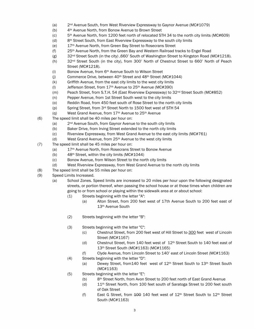
3
(a) 2nd Avenue South, from West Riverview Expressway to Gaynor Avenue (MC#1079)
(b) 4th Avenue North, from Bonow Avenue to Brown Street
(c) 5th Avenue North, from 1200 feet north of relocated STH 34 to the north city limits (MC#609)
(d) 8th Street South, from East Riverview Expressway to the south city limits
(e) 17th Avenue North, from Green Bay Street to Rosecrans Street
(f) 25th Avenue North, from the Green Bay and Western Railroad tracks to Engel Road
(g) 32nd Street South (in the city) ,660’ South of Washington Street to Kingston Road (MC#1218).
(h) 32nd Street South (in the city), from 300’ North of Chestnut Street to 660’ North of Peach
Street (MC#1218).
(i) Bonow Avenue, from 6th Avenue South to Wilson Street
(j) Commerce Drive, between 40th Street and 48th Street (MC#1044)
(k) Griffith Avenue, from the east city limits to the west city limits
(l) Jefferson Street, from 17th Avenue to 25th Avenue (MC#390)
(m) Peach Street, from S.T.H. 54 (East Riverview Expressway) to 32nd Street South (MC#852)
(n) Pepper Avenue, from 1st Street South west to the city limits
(o) Reddin Road, from 450 feet south of Rose Street to the north city limits
(p) Spring Street, from 3rd Street North to 1500 feet west of STH 54
(q) West Grand Avenue, from 17th Avenue to 25th Avenue
(6) The speed limit shall be 40 miles per hour on:
(a) 2nd Avenue South, from Gaynor Avenue to the south city limits
(b) Baker Drive, from Irving Street extended to the north city limits
(c) Riverview Expressway, from West Grand Avenue to the east city limits (MC#761)
(d) West Grand Avenue, from 25th Avenue to the west city limits
(7) The speed limit shall be 45 miles per hour on:
(a) 17th Avenue North, from Rosecrans Street to Bonow Avenue
(b) 48th Street, within the city limits (MC#1044)
(c) Bonow Avenue, from Wilson Street to the north city limits
(d) West Riverview Expressway, from West Grand Avenue to the north city limits
(8) The speed limit shall be 55 miles per hour on:
(9) Speed Limits Increased.
(a) School Zones. Speed limits are increased to 20 miles per hour upon the following designated
streets, or portion thereof, when passing the school house or at those times when children are
going to or from school or playing within the sidewalk area at or about school:
(1) Streets beginning with the letter "A":
(a) Alton Street, from 200 feet west of 17th Avenue South to 200 feet east of
13th Avenue South
(2) Streets beginning with the letter "B":
(3) Streets beginning with the letter "C":
(c) Chestnut Street, from 200 feet west of Hill Street to 300 feet west of Lincoln
Street (MC#1167)
(d) Chestnut Street, from 140 feet west of 12th Street South to 140 feet east of
13th Street South (MC#1163) (MC#1165)
(f) Clyde Avenue, from Lincoln Street to 140’ east of Lincoln Street (MC#1163)
(4) Streets beginning with the letter "D":
(a) Dewey Street, from140 feet west of 12th Street South to 13th Street South
(MC#1163)
(5) Streets beginning with the letter "E":
(b) 8th Street North, from Avon Street to 200 feet north of East Grand Avenue
(d) 11th Street North, from 100 feet south of Saratoga Street to 200 feet south
of Oak Street
(f) East G Street, from 100 140 feet west of 12th Street South to 12th Street
South (MC#1163)
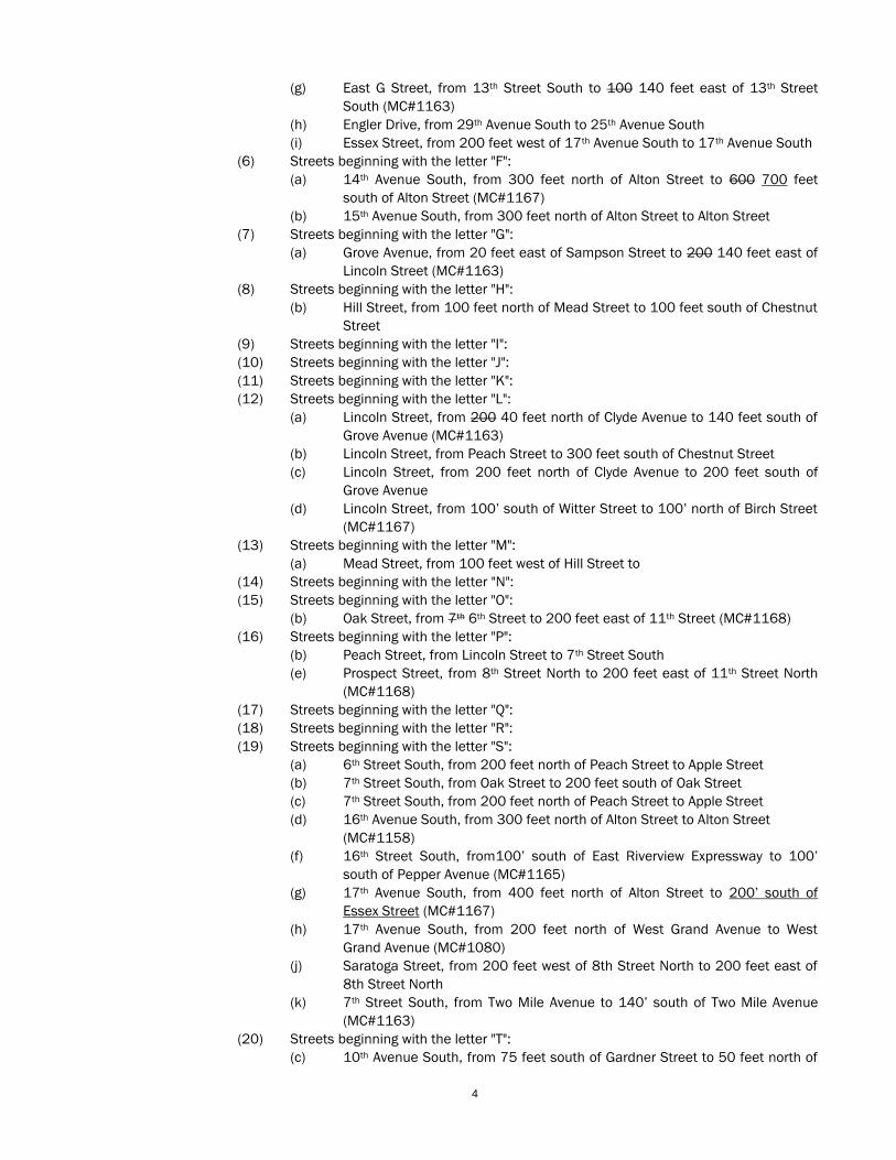
4
(g) East G Street, from 13th Street South to 100 140 feet east of 13th Street
South (MC#1163)
(h) Engler Drive, from 29th Avenue South to 25th Avenue South
(i) Essex Street, from 200 feet west of 17th Avenue South to 17th Avenue South
(6) Streets beginning with the letter "F":
(a) 14th Avenue South, from 300 feet north of Alton Street to 600 700 feet
south of Alton Street (MC#1167)
(b) 15th Avenue South, from 300 feet north of Alton Street to Alton Street
(7) Streets beginning with the letter "G":
(a) Grove Avenue, from 20 feet east of Sampson Street to 200 140 feet east of
Lincoln Street (MC#1163)
(8) Streets beginning with the letter "H":
(b) Hill Street, from 100 feet north of Mead Street to 100 feet south of Chestnut
Street
(9) Streets beginning with the letter "I":
(10) Streets beginning with the letter "J":
(11) Streets beginning with the letter "K":
(12) Streets beginning with the letter "L":
(a) Lincoln Street, from 200 40 feet north of Clyde Avenue to 140 feet south of
Grove Avenue (MC#1163)
(b) Lincoln Street, from Peach Street to 300 feet south of Chestnut Street
(c) Lincoln Street, from 200 feet north of Clyde Avenue to 200 feet south of
Grove Avenue
(d) Lincoln Street, from 100’ south of Witter Street to 100’ north of Birch Street
(MC#1167)
(13) Streets beginning with the letter "M":
(a) Mead Street, from 100 feet west of Hill Street to
(14) Streets beginning with the letter "N":
(15) Streets beginning with the letter "O":
(b) Oak Street, from 7th 6th Street to 200 feet east of 11th Street (MC#1168)
(16) Streets beginning with the letter "P":
(b) Peach Street, from Lincoln Street to 7th Street South
(e) Prospect Street, from 8th Street North to 200 feet east of 11th Street North
(MC#1168)
(17) Streets beginning with the letter "Q":
(18) Streets beginning with the letter "R":
(19) Streets beginning with the letter "S":
(a) 6th Street South, from 200 feet north of Peach Street to Apple Street
(b) 7th Street South, from Oak Street to 200 feet south of Oak Street
(c) 7th Street South, from 200 feet north of Peach Street to Apple Street
(d) 16th Avenue South, from 300 feet north of Alton Street to Alton Street
(MC#1158)
(f) 16th Street South, from100’ south of East Riverview Expressway to 100’
south of Pepper Avenue (MC#1165)
(g) 17th Avenue South, from 400 feet north of Alton Street to 200’ south of
Essex Street (MC#1167)
(h) 17th Avenue South, from 200 feet north of West Grand Avenue to West
Grand Avenue (MC#1080)
(j) Saratoga Street, from 200 feet west of 8th Street North to 200 feet east of
8th Street North
(k) 7th Street South, from Two Mile Avenue to 140’ south of Two Mile Avenue
(MC#1163)
(20) Streets beginning with the letter "T":
(c) 10th Avenue South, from 75 feet south of Gardner Street to 50 feet north of
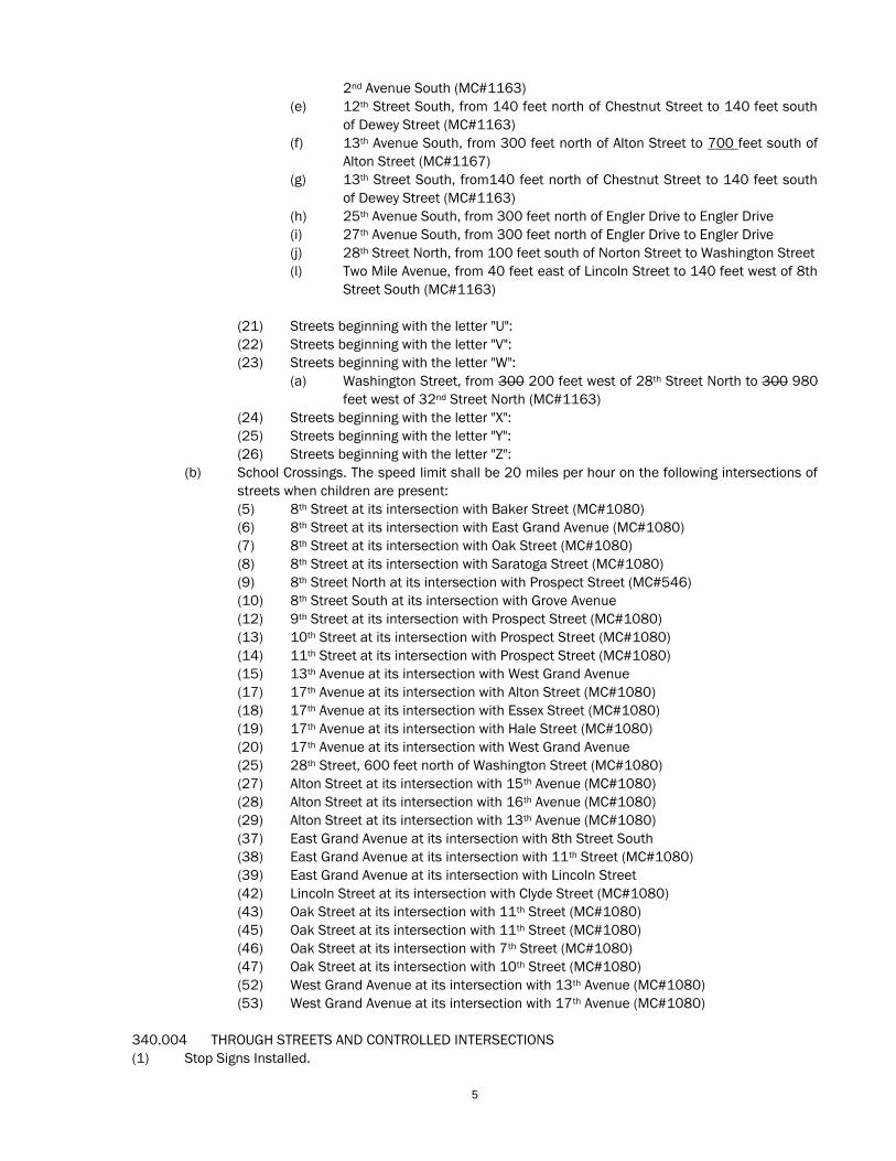
5
2nd Avenue South (MC#1163)
(e) 12th Street South, from 140 feet north of Chestnut Street to 140 feet south
of Dewey Street (MC#1163)
(f) 13th Avenue South, from 300 feet north of Alton Street to 700 feet south of
Alton Street (MC#1167)
(g) 13th Street South, from140 feet north of Chestnut Street to 140 feet south
of Dewey Street (MC#1163)
(h) 25th Avenue South, from 300 feet north of Engler Drive to Engler Drive
(i) 27th Avenue South, from 300 feet north of Engler Drive to Engler Drive
(j) 28th Street North, from 100 feet south of Norton Street to Washington Street
(l) Two Mile Avenue, from 40 feet east of Lincoln Street to 140 feet west of 8th
Street South (MC#1163)
(21) Streets beginning with the letter "U":
(22) Streets beginning with the letter "V":
(23) Streets beginning with the letter "W":
(a) Washington Street, from 300 200 feet west of 28th Street North to 300 980
feet west of 32nd Street North (MC#1163)
(24) Streets beginning with the letter "X":
(25) Streets beginning with the letter "Y":
(26) Streets beginning with the letter "Z":
(b) School Crossings. The speed limit shall be 20 miles per hour on the following intersections of
streets when children are present:
(5) 8th Street at its intersection with Baker Street (MC#1080)
(6) 8th Street at its intersection with East Grand Avenue (MC#1080)
(7) 8th Street at its intersection with Oak Street (MC#1080)
(8) 8th Street at its intersection with Saratoga Street (MC#1080)
(9) 8th Street North at its intersection with Prospect Street (MC#546)
(10) 8th Street South at its intersection with Grove Avenue
(12) 9th Street at its intersection with Prospect Street (MC#1080)
(13) 10th Street at its intersection with Prospect Street (MC#1080)
(14) 11th Street at its intersection with Prospect Street (MC#1080)
(15) 13th Avenue at its intersection with West Grand Avenue
(17) 17th Avenue at its intersection with Alton Street (MC#1080)
(18) 17th Avenue at its intersection with Essex Street (MC#1080)
(19) 17th Avenue at its intersection with Hale Street (MC#1080)
(20) 17th Avenue at its intersection with West Grand Avenue
(25) 28th Street, 600 feet north of Washington Street (MC#1080)
(27) Alton Street at its intersection with 15th Avenue (MC#1080)
(28) Alton Street at its intersection with 16th Avenue (MC#1080)
(29) Alton Street at its intersection with 13th Avenue (MC#1080)
(37) East Grand Avenue at its intersection with 8th Street South
(38) East Grand Avenue at its intersection with 11th Street (MC#1080)
(39) East Grand Avenue at its intersection with Lincoln Street
(42) Lincoln Street at its intersection with Clyde Street (MC#1080)
(43) Oak Street at its intersection with 11th Street (MC#1080)
(45) Oak Street at its intersection with 11th Street (MC#1080)
(46) Oak Street at its intersection with 7th Street (MC#1080)
(47) Oak Street at its intersection with 10th Street (MC#1080)
(52) West Grand Avenue at its intersection with 13th Avenue (MC#1080)
(53) West Grand Avenue at its intersection with 17th Avenue (MC#1080)
340.004 THROUGH STREETS AND CONTROLLED INTERSECTIONS
(1) Stop Signs Installed.
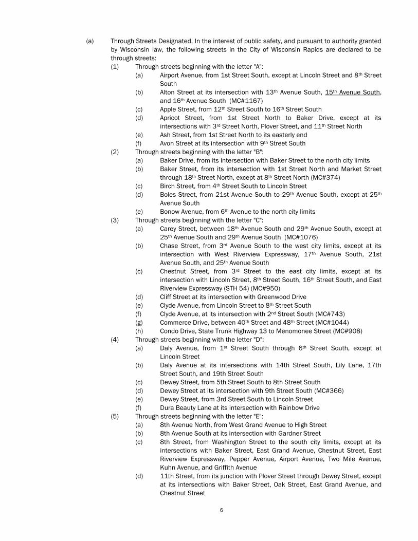
6
(a) Through Streets Designated. In the interest of public safety, and pursuant to authority granted
by Wisconsin law, the following streets in the City of Wisconsin Rapids are declared to be
through streets:
(1) Through streets beginning with the letter "A":
(a) Airport Avenue, from 1st Street South, except at Lincoln Street and 8th Street
South
(b) Alton Street at its intersection with 13th Avenue South, 15th Avenue South,
and 16th Avenue South (MC#1167)
(c) Apple Street, from 12th Street South to 16th Street South
(d) Apricot Street, from 1st Street North to Baker Drive, except at its
intersections with 3rd Street North, Plover Street, and 11th Street North
(e) Ash Street, from 1st Street North to its easterly end
(f) Avon Street at its intersection with 9th Street South
(2) Through streets beginning with the letter "B":
(a) Baker Drive, from its intersection with Baker Street to the north city limits
(b) Baker Street, from its intersection with 1st Street North and Market Street
through 18th Street North, except at 8th Street North (MC#374)
(c) Birch Street, from 4th Street South to Lincoln Street
(d) Boles Street, from 21st Avenue South to 29th Avenue South, except at 25th
Avenue South
(e) Bonow Avenue, from 6th Avenue to the north city limits
(3) Through streets beginning with the letter "C":
(a) Carey Street, between 18th Avenue South and 29th Avenue South, except at
25th Avenue South and 29th Avenue South (MC#1076)
(b) Chase Street, from 3rd Avenue South to the west city limits, except at its
intersection with West Riverview Expressway, 17th Avenue South, 21st
Avenue South, and 25th Avenue South
(c) Chestnut Street, from 3rd Street to the east city limits, except at its
intersection with Lincoln Street, 8th Street South, 16th Street South, and East
Riverview Expressway (STH 54) (MC#950)
(d) Cliff Street at its intersection with Greenwood Drive
(e) Clyde Avenue, from Lincoln Street to 8th Street South
(f) Clyde Avenue, at its intersection with 2nd Street South (MC#743)
(g) Commerce Drive, between 40th Street and 48th Street (MC#1044)
(h) Condo Drive, State Trunk Highway 13 to Menomonee Street (MC#908)
(4) Through streets beginning with the letter "D":
(a) Daly Avenue, from 1st Street South through 6th Street South, except at
Lincoln Street
(b) Daly Avenue at its intersections with 14th Street South, Lily Lane, 17th
Street South, and 19th Street South
(c) Dewey Street, from 5th Street South to 8th Street South
(d) Dewey Street at its intersection with 9th Street South (MC#366)
(e) Dewey Street, from 3rd Street South to Lincoln Street
(f) Dura Beauty Lane at its intersection with Rainbow Drive
(5) Through streets beginning with the letter "E":
(a) 8th Avenue North, from West Grand Avenue to High Street
(b) 8th Avenue South at its intersection with Gardner Street
(c) 8th Street, from Washington Street to the south city limits, except at its
intersections with Baker Street, East Grand Avenue, Chestnut Street, East
Riverview Expressway, Pepper Avenue, Airport Avenue, Two Mile Avenue,
Kuhn Avenue, and Griffith Avenue
(d) 11th Street, from its junction with Plover Street through Dewey Street, except
at its intersections with Baker Street, Oak Street, East Grand Avenue, and
Chestnut Street
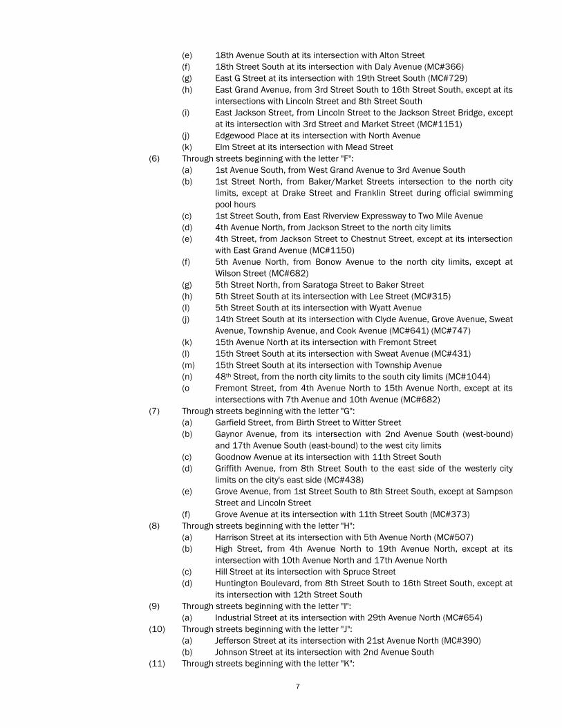
7
(e) 18th Avenue South at its intersection with Alton Street
(f) 18th Street South at its intersection with Daly Avenue (MC#366)
(g) East G Street at its intersection with 19th Street South (MC#729)
(h) East Grand Avenue, from 3rd Street South to 16th Street South, except at its
intersections with Lincoln Street and 8th Street South
(i) East Jackson Street, from Lincoln Street to the Jackson Street Bridge, except
at its intersection with 3rd Street and Market Street (MC#1151)
(j) Edgewood Place at its intersection with North Avenue
(k) Elm Street at its intersection with Mead Street
(6) Through streets beginning with the letter "F":
(a) 1st Avenue South, from West Grand Avenue to 3rd Avenue South
(b) 1st Street North, from Baker/Market Streets intersection to the north city
limits, except at Drake Street and Franklin Street during official swimming
pool hours
(c) 1st Street South, from East Riverview Expressway to Two Mile Avenue
(d) 4th Avenue North, from Jackson Street to the north city limits
(e) 4th Street, from Jackson Street to Chestnut Street, except at its intersection
with East Grand Avenue (MC#1150)
(f) 5th Avenue North, from Bonow Avenue to the north city limits, except at
Wilson Street (MC#682)
(g) 5th Street North, from Saratoga Street to Baker Street
(h) 5th Street South at its intersection with Lee Street (MC#315)
(I) 5th Street South at its intersection with Wyatt Avenue
(j) 14th Street South at its intersection with Clyde Avenue, Grove Avenue, Sweat
Avenue, Township Avenue, and Cook Avenue (MC#641) (MC#747)
(k) 15th Avenue North at its intersection with Fremont Street
(l) 15th Street South at its intersection with Sweat Avenue (MC#431)
(m) 15th Street South at its intersection with Township Avenue
(n) 48th Street, from the north city limits to the south city limits (MC#1044)
(o Fremont Street, from 4th Avenue North to 15th Avenue North, except at its
intersections with 7th Avenue and 10th Avenue (MC#682)
(7) Through streets beginning with the letter "G":
(a) Garfield Street, from Birth Street to Witter Street
(b) Gaynor Avenue, from its intersection with 2nd Avenue South (west-bound)
and 17th Avenue South (east-bound) to the west city limits
(c) Goodnow Avenue at its intersection with 11th Street South
(d) Griffith Avenue, from 8th Street South to the east side of the westerly city
limits on the city's east side (MC#438)
(e) Grove Avenue, from 1st Street South to 8th Street South, except at Sampson
Street and Lincoln Street
(f) Grove Avenue at its intersection with 11th Street South (MC#373)
(8) Through streets beginning with the letter "H":
(a) Harrison Street at its intersection with 5th Avenue North (MC#507)
(b) High Street, from 4th Avenue North to 19th Avenue North, except at its
intersection with 10th Avenue North and 17th Avenue North
(c) Hill Street at its intersection with Spruce Street
(d) Huntington Boulevard, from 8th Street South to 16th Street South, except at
its intersection with 12th Street South
(9) Through streets beginning with the letter "I":
(a) Industrial Street at its intersection with 29th Avenue North (MC#654)
(10) Through streets beginning with the letter "J":
(a) Jefferson Street at its intersection with 21st Avenue North (MC#390)
(b) Johnson Street at its intersection with 2nd Avenue South
(11) Through streets beginning with the letter "K":
8
(a) Kingston Road, through from Baker Drive to 29th Street North
(12) Through streets beginning with the letter "L":
(a) LaVigne Street at its intersection with 2nd Street North
(b) Lee Street at its intersection with 6th Street South (MC#398)
(c) Lincoln Street, from East Grand Avenue to Two Mile Avenue, except at its
intersections with Chestnut Street, East Riverview Expressway, Lincoln
Street, and Grove Avenue (MC#786)
(d) Lincoln Street at its intersections with Thalacker Avenue, Ruby Avenue, and
Maple Manor Drive (MC#438)
(e) Lincoln Street at its intersections with Pine Avenue and Brianwood Avenue
(13) Through streets beginning with the letter "M":
(a) Market Street at its intersection with Avon Street
(b) McKinley Street, at 6th Avenue North, west-bound traffic only
(c) Miller Avenue, from 1st Street South to Sampson Street
(d) Miller Avenue, from Lincoln Street to 7th Street South
(14) Through streets beginning with the letter "N":
(a) 9th Avenue North at its intersections with 8th Avenue North, McKinley Street
and Harrison Street (MC#377) (MC#1034)
(b) 9th Street South at its intersection with Grape Street
(c) 19th Avenue South at its intersection with Clark Street
(d) Norton Street at its intersection with 26th Street North (MC#613)
(15) Through streets beginning with the letter "O":
(a) Oak Street, from East Jackson Street to 16th Street, except at its
intersection with 8th Street
(b) Oak Street at its intersection with 20th Street and 28th Street (MC#950)
(16) Through streets beginning with the letter "P":
(a) Peach Street at its intersection with 19th Street South
(b) Peach Street at its intersection with 7th Street South (MC#800)
(c) Peach Street, from S.T.H. 54 (East Riverview Expressway) to 32nd Street
South (MC#852)
(d) Pepper Avenue, from Golf Course Road to 16th Street South, except at its
intersections with 1st Street South, Lincoln Street and 8th Street South
(e) Piltz Avenue at its intersections with 2nd Street South and 4th Street South
(f) Pleasant View Drive at its intersections with 2nd Street North and 3rd Street
North
(g) Plover Street, from 1st Street North to its junction with 11th Street North,
except at 3rd Street North
(h) Prospect Street at its intersection with 9th Street North
(17) Through streets beginning with the letter "Q":
(18) Through streets beginning with the letter "R":
(a) Reddin Road, from 4th Avenue to the north city limits
(b) Riverview Expressway, from the northwest city limits to the northeast city
limits, except at Wilson Street, High Street, West Grand Avenue, Chase
Street, 2nd Avenue south, 3rd Avenue South, Lincoln Street, 8th Street, South,
16th Street South, County Trunk W, and Washington Street. (MC#852)
(c) Rosecrans Street, from 10th Avenue North to 17th Avenue North
(19) Through streets beginning with the letter "S":
(a) 2nd Avenue South, from its junction with 1st Avenue South to the south city
limits, except at West Riverview Expressway
(b) 2nd Street South, from East Grand Avenue to its intersection with Mead
Street
(c) 7th Avenue South at its intersection with Goggins Street
(d) 7th Street South, from Daly Avenue to Pepper Avenue
(e) 7th Street South at its intersection with Pine Avenue
9
(f) 16th Avenue South at its intersection with Clark Street
(g) 16th Street South, from Griffith Avenue through Monroe Street, except at its
intersections with Two Mile Avenue, Airport Avenue, East Riverview
Expressway, Chestnut Street, Peach Street, Baker Street, and Apricot Street
(MC#908)
(h) 17th Avenue, from Bonow Avenue to Gaynor Avenue, except at its
intersections with West Grand Avenue and Chase Street
(i) Sampson Street, from Daly Avenue to Two Mile Avenue, except at Pepper
Avenue and Airport Avenue
(j) Saratoga Street, from East Jackson Street to the east city limits, except at its
intersection with 8th Street North, 11th Street North, 16th Street North, East
Riverview Expressway (STH 54), and 32nd Street (MC#950)
(l) Spring Street, from 1st Street North to Baker Drive (Highway 54)
(m) Strodman Avenue, from 1st Street South to Sampson Street
(n) Strodman Avenue at its intersection with Rapids Street
(o) Sweat Avenue at its intersection with 9th Street South, 11th Street South,
and 13th Street South (MC#1129)
(20) Through streets beginning with the letter "T":
(a) 3rd Avenue South, from West Grand Avenue through its intersection with 1st
Avenue (MC#921)
(b) 3rd Street, from Jackson Street to East Riverview Expressway, except at its
intersection with East Grand Avenue
(c) 3rd Street North, from Drake Street to its northerly end except at its
intersection with Plover Street and Apricot Street
(d) 3rd Street South, from Miller Avenue to Two Mile Avenue, except at its
intersections with Grove Avenue, Pepper Avenue, and Airport Avenue
(e) 10th Avenue North, from Rainbow Drive to Brown Street (MC#622)
(f) 10th Avenue North, from West Grand Avenue through Jefferson Street
(MC#622)
(g) 10th Avenue South, from Chase Street to 2nd Avenue South
(h) 10th Street North at its intersection with Prospect Street
(i) 10th Street South at its intersection with Grape Street
(j) 10th Street South at its intersections with Sweat Avenue, Grove Avenue, and
Goodnow Avenue
(k) 12th Avenue North at its intersection with McKinley Street
(l) 12th Avenue South, from West Grand Avenue to Chase Street
(m) 12th Street North at its intersection with Washington Street
(n) 12th Street North, from Baker Street to Oak Street, except at Saratoga Street
(MC#370)
(o) 12th Street South, from East Grand Avenue to Airport Avenue, except at
Chestnut Street, East Riverview Expressway, and Pepper Avenue
(p) 20th Street North at its intersection Baker Street
(q) 20th Street South at its intersection with Cook Avenue (MC#438)
(r) 20th Street South at its intersection with Whitrock Avenue and Murgy Drive
(MC#818)
(s) 21st Avenue South, from West Grand Avenue to Gaynor Avenue
(t) 23rd Street North, from Evergreen Lane to Washington Street, except at
Irving Street (MC#613)
(u) 24th Street at its intersection with Oak Street and 23rd Street South
(MC#950)
(v) 25th Avenue South, from Gaynor Avenue through Engel Road, except at its
intersection with West Grand Avenue
(w) 26th Street North at its intersections with Amundson Street and Franklin
Street
10
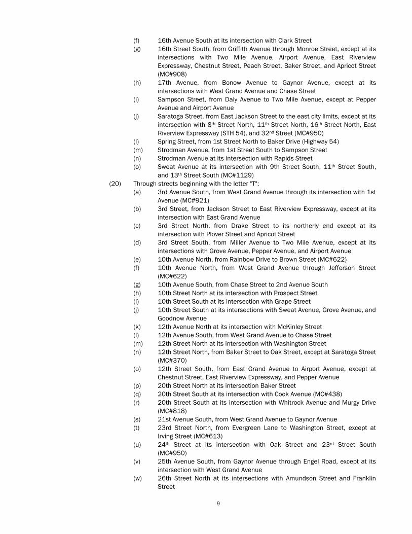
(x) 27th Avenue South at its intersection with Engler Drive (MC#679)
(y) 28th Street North at its intersections with Norton Street and Amundson
Street
(z) 29th Avenue North, from Industrial Street to Engel Road (MC #1076)
(aa) 32nd Street North, from Washington Street through Kingston Road
(ab) Taylor Avenue, from 1st Street South to Lincoln Street, except at its
intersection with Sampson Street
(ac) Township Avenue, from 8th Street South to 14th Street South
(ad) Two Mile Avenue, from 1st Street South through 16th Street South, except at
Lincoln Street and 8th Street South
(21) Through streets beginning with the letter "U":
(22) Through streets beginning with the letter "V":
(23) Through streets beginning with the letter "W":
(a) Washington Street, from Baker Drive to 32nd Street North, except at East
Riverview Expressway (STH 54) (MC #950)
(b) Washington Street at its intersections with 15th Street North and 18th
Street North (MC#821)
(c) West Grand Avenue, from the west city limits through 1st Avenue, except at
its intersections with 17th Avenue, West Riverview Expressway, Jackson
Street, and 3rd Avenue
(d) West Jackson Street, from West Grand Avenue through 2nd Avenue
(MC#1125)
(e) Whitrock Avenue, from the west city limits to the east city limits, except at 8th
Street, 16th Street, and 20th Street (MC#950)
(f) Wilson Street at its intersection with 5th Avenue (MC#682)
(g) Wisconsin Street at its intersection with 7th Street North
(h) Witter Street, from 4th Street South to Mead Street
(i) Wood Avenue at its intersection with 10th Street South
(24) Through streets beginning with the letter "X":
(25) Through streets beginning with the letter "Y":
(26) Through streets beginning with the letter "Z":
(b) Designation of Location of Stop Signs. In the interest of public safety, stop signs will be
installed at the following locations to control traffic on the streets over which the Wisconsin
Rapids Common Council has exclusive jurisdiction.
(1) On 1st Street North, at Drake Street and Franklin Streets, only during official
swimming pool hours
(2) On 1st Street North, at its intersection with Oak Street, for south-bound traffic
(MC#782)
(3) At the southwest corner of the intersection of LaVigne Street and 3rd Street North
(4) At the southwest corner of the intersection of McKinley Street and 6th Avenue North,
for east-/west-bound traffic entering the intersection
(5) At the southeast corner of the intersection of 6th Avenue North and McKinley Street,
for north-bound traffic
(6) South-bound traffic on 2nd Street North at its intersection with Oak Street
(7) On 6th Street South at its intersection with Apple Street
(8) On Peach Street, with its intersection with 6th Street South
(9) South-bound 6th Street South at its intersection with Peach Street
(10) North-bound 4th Street South at its intersection with Birch Street (MC#318)
(11) On Burt Street at its intersections with Dewey Street and 6th Street South (MC#342)
(12) On Boles Street at its intersection with 29th Avenue South (MC#487)
(13) On Pepper Avenue, at Golf Course Road (MC#617)
(14) On the northwest corner of 4th Avenue and High Street (MC#780)
(15) On all dead end streets that end with an intersection with another street ("T"
intersections) (MC#844)
11
(16) 240 feet north of 3rd Avenue South at the crosswalks at the entrance to the Lowell
Center. (MC#1061)
(17) 350 feet north of 3rd Avenue South at the crosswalks at the main entrance to the
Centralia Center. (MC#1061)
(c) Designation of Location of Four-way Stops. In the intersect of public safety, four-way stop
signs shall be installed at the following intersections to control traffic on the street over which
the Wisconsin Rapids Common Council has exclusive jurisdiction. The intersection of:
(1) 1st Street South and Pepper Avenue (MC#851)
(2) 2nd Street and East Grand Avenue (MC#1125)
(3) 3rd Avenue and West Grand Avenue (MC#1125)
(4) 3rd Street and East Grand Avenue (MC #1125)
(5) 3rd Street North and Apricot Street
(6) 3rd Street North and Drake Street
(7) 3rd Street North and Plover Street
(8) 12th Street South and Chestnut Street for the duration of the 8th Street
South/Riverview Expressway construction detour (MC#732)
(9) 14th Avenue South and Alton Street
(10) 16th Street South and Airport Avenue (MC#1034)
(11) 16th Street South and Chestnut Street
(12) 16th Street South and Peach Street
(13) 17th Avenue South and Chase Street
(14) 32nd Street North and Washington Street
(15) Lincoln Street and Chestnut Street
(16) Lincoln Street and Grove Avenue
(17) Lincoln Street and Two Mile Avenue
(18) Lincoln Street and Pepper Avenue (MC#786)
(2) Controlled Intersections Designated. In the interest of public safety, and with approval of the
Wisconsin Rapids Common Council, the following intersections are declared controlled intersections
and traffic control signals shall be installed thereon in conformity with the Wisconsin Official Traffic
Control Device Manual and the provisions of this code. The intersection of:
(a) 2nd Avenue South with West Riverview Expressway
(e) 6th Avenue, West Grand Avenue, and West Jackson Street
(f) 8th Street South and Airport Avenue
(g) 8th Street South and Griffith Avenue
(h) 8th Street South and Kuhn Avenue
(i) 8th Street South and Pepper Avenue
(j) 8th Street South and Two Mile Avenue
(k) 17th Avenue with West Grand Avenue
(l) Baker Street with 8th Street North
(m) Baker Street, Market Street, and 1st Street North
(n) Chase Street with West Riverview Expressway
(o) Chestnut Street with 8th Street South
(p) County Trunk W with 24th Street South (MC#1080)
(q) East Grand Avenue with 8th Street South
(t) East Grand Avenue, East Jackson Street, and Lincoln Street
(u) East Jackson Street, Market Street, and 3rd Street South (MC#1151)
(v) East Riverview Expressway with 3rd Street South
(w) East Riverview Expressway with 8th Street South
(x) East Riverview Expressway with 12th Street South
(y) East Riverview Expressway with 16th Street South (MC#761)
(z) East Riverview Expressway with Lincoln Street
(aa) East Riverview Expressway at County Trunk W (MC#852)
(ab) East Riverview Expressway at Washington Street (MC#852)
(ac) West Grand Avenue with West Riverview Expressway
12
(ad) West Grand Avenue with 25th Avenue (MC#1080)
(ae) West Riverview Expressway with High Street
(af) West Riverview Expressway with Wilson Street
(3) Yield Signs to be Erected. The city traffic engineer is authorized to erect yield right-of-way signs
conforming to the Wisconsin Official traffic Control Device Manual at the following intersections on
highways in the exclusive jurisdiction of the city. The provisions of Section 349.07(7)(a), Wisconsin
State Statutes, shall apply.
(a) Yield Right of Way. In the interest of public safety, and with approval of the Wisconsin Rapids
Common Council, yield right-of-way signs shall be erected so that traffic on the first-named
streets shall yield right-of-way to traffic approaching on the streets being entered at the
following locations.
(1) 2nd Street South at its intersection with Woodland Drive (MC#402)
(2) 5th Street South at its intersection with Dewey Street (MC#543)
(3) 7th Avenue at its intersection with Fremont Street (MC#682)
(4) 7th Street North at its intersection with Avon Street (MC#511)
(5) 7th Street South at its intersection with Daly Avenue
(6) 9th Street South at its intersection with Apple Street
(7) 9th Street South at its intersection with East G Street (MC#676)
(8) 10th Street South at its intersection with Dewey Street
(9) 10th Street South at its intersection with Apple Street
(10) 11th Avenue South at its intersection with Alton Street
(11) 15th Avenue South at its intersection with Alton Street
(12) 15th Street South at its intersection with Peach Street (MC#533)
(13) 17th Avenue South at its intersection with 2nd Avenue South (MC#792)
(14) 17th Street North at its intersection with Washington Street (MC#821)
(15) 18th Avenue South at its intersection with Hale Street (MC#650)
(16) 19th Avenue South at its intersection with Alton Street (MC#479)
(17) 20th Avenue South at its intersection with Alton Street (MC#511)
(18) 21st Street North at its intersection with Irving Street (MC#773)
(19) 22nd Avenue South at its intersection with Wickham Avenue
(20) 23rd Street North at its intersection with Irving Street (MC#613)
(21) 31st Street North at its intersection with Amundson Street (MC#915)
(22) Apricot Street at its intersection with 22nd Street North (MC#836)
(23) Avon Street at its intersection with 10th Street North (MC#976)
(24) Boles Street at its intersection with 13th Avenue South (MC#498)
(25) Engler Drive at its intersection with 25th Avenue South (MC#503)
(26) Essex Street at its intersection with 18th Avenue South (MC#511)
(27) Essex Street at its intersection with 20th Avenue (MC#507)
(28) Franklin Street at its intersection with 22nd Street North (MC#836)
(29) Garfield Street at its intersection with Hill Street
(30) Goggins Street at its intersection with 8th Avenue South
(31) Hale Street at its intersection with 20th Avenue South (MC#407)
(32) Hill Street at its intersection with Elm Street
(33) Irving Street at its intersection with 22nd Street North (MC#836)
(34) Lyon Street at its intersection with Boles Street
(35) Mead Street at its intersection with Hill Street
(36) McKinley Street at its intersection with Canal Street
(37) Park Street at its intersection with 13th Avenue (MC#483)
(38) Park Street at its intersection with Boles Street (MC#424)
(39) Peach Street at its intersection with 9th Street South
(40) Peach Street at its intersection with 14th Street South (MC#681)
(41) Pear Street at its intersection with 9th Street South
(42) Pear Street at its intersection with 10th Street South (MC#676)
(43) Plumb Street at its intersection with 9th Street South
13
(44) South Strawberry Lane at its intersection with North Strawberry Lane (MC#905)
(45) Woodbine Street at its intersection with Boles Street
(46) Wylie Street at its intersection with 8th Street North (MC#681)
(b) Yield Right-of-way; Right Turns. In the interest of public safety, and with the approval of the
Wisconsin Rapids Common Council, yield right-of-way signs shall be erected at the following
locations so that right-turning traffic on the first-named street shall yield the right-of-way to
traffic approaching on the streets being entered for the specific traffic conditions:
(1) 1st Street North, for south-bound traffic turning west onto 1st Street North at its
intersection with Baker Street
(2) 1st Street North, for south-bound traffic turning east onto East Jackson Street
(3) 2nd Avenue South, for north-bound traffic turning east onto Riverview Expressway
(4) 2nd Avenue South, for south-bound traffic turning west onto Riverview Expressway
(5) 3rd Avenue North, for south-bound traffic turning west onto West Jackson Street
(6) 3rd Street South, for south-bound traffic turning west onto Riverview Expressway
(7) 3rd Street South, for north-bound traffic turning east onto Riverview Expressway
(8) 5th Avenue North, for north-bound traffic turning east onto Bonow Avenue
(9) 8th Street North, for north-bound traffic turning east onto Baker Street
(10) 8th Street South, for south-bound traffic turning west onto Riverview Expressway
(11) 8th Street South, for north-bound traffic turning east onto Riverview Expressway
(12) 12th Street South, for north-bound traffic turning onto Riverview Expressway
(13) 12th Street South, for south-bound traffic turning onto Riverview Expressway
(14) 16th Street North, for north-bound traffic turning east onto Baker Street
(15) 16th Street South, for south-bound traffic turning west onto West Riverview
Expressway (MC#761)
(16) Chase Street, for east-bound traffic turning south onto West Riverview Expressway
(17) Chase Street, for west-bound traffic turning north onto West Riverview Expressway
(18) Gaynor Avenue, for east-bound traffic turning south onto 17th Avenue South
(19) High Street, for east-bound traffic turning onto Riverview Expressway
(20) High Street, for west-bound traffic turning onto Riverview Expressway
(21) Lincoln Street, for south-bound traffic turning west onto Riverview Expressway
(22) Lincoln Street, for north-bound traffic turning east onto Riverview Expressway
(23) Market Street, for north-bound traffic turning east onto Baker Street
(24) Peach Street, for west-bound traffic turning north onto Lincoln Street
(25) West Grand Avenue at its intersection with Jackson Street, for east-bound traffic
turning south onto West Grand Avenue
(26) West Grand Avenue, for east-bound traffic turning south onto Riverview Expressway
(27) West Jackson Street at its intersection with 4th Avenue North, for east-bound traffic
turning south onto West Jackson Street
(4) Operators to Obey Traffic Control Devices. Every operator of a vehicle approaching an intersection at
which an official traffic control device is erected, in accordance with this section and Section 340.002
of this code, shall obey the direction of such official traffic control device as required by the Wisconsin
State Statutes incorporated by reference in Section 340.001 of this code. Operators of vehicles
approaching a stop sign shall stop before entering a highway, as requested by Section 346.46,
Wisconsin State Statutes. Operators approaching intersections at which a yield sign has been installed
shall yield right-of-way to other vehicle, as required by Section 346.18(6), Wisconsin State Statutes.
(5) Through Streets and Controlled Intersections; Fold-down Stop Signs. In the interest of public safety
and pursuant to authority granted by Wisconsin law, the following streets in the City of Wisconsin
Rapids are declared to be through streets when the traffic control signal fails to function and the stop
signs are unfolded by the police department.
(a) 8th Street South at its intersection with Airport Avenue
(b) 8th Street South at its intersection with Chestnut Street
(c) 8th Street South at its intersection with Pepper Avenue
(d) 8th Street South at its intersection with Two Mile Avenue
(e) Baker Street at its intersection with Market Street and 1st Street North
14
(f) Baker Street at its intersection with 8th Street North
(g) East Riverview Expressway at its intersection with Lincoln Street
(h) East Riverview Expressway at its intersection with 3rd Street South
(i) East Jackson Street at its intersection with 3rd Street North
(j) East Grand Avenue at its intersection with 3rd Street South
(k) East Grand Avenue at its intersection with 2nd Street South
(l) East Grand Avenue at its intersection with Lincoln Street
(m) East Riverview Expressway at its intersection with 12th Street South
(n) East Riverview Expressway at its intersection with Washington Street (MC#852)
(o) West Grand Avenue at its intersection with 17th Avenue
(p) West Grand Avenue at its intersection with 3rd Avenue
(q) West Jackson Street (east leg) and West Grand Avenue (west leg) at its intersection with 6th
Avenue (north leg) and West Grand Avenue (south leg)
(r) West Jackson Street at its intersection with 3rd Avenue North
(s) West Jackson Street (south leg) and 4th Avenue (north leg) at its intersection with West
Jackson Street (west leg)
(t) West Riverview Expressway at its intersection with Chase Street
(u) West Riverview Expressway at its intersection with 2nd Avenue South
(v) West Riverview Expressway at its intersection with Wilson Street
(w) West Riverview Expressway at its intersection with High Street
(6) Designation of Locations of Four-way Stops at Controlled Intersections (Fold-down Stop Signs). In the
interest of public safety and pursuant to authority granted by Wisconsin law, four-way stops shall be
installed when traffic control signals fail to function by folding them down by the police department at
the following intersections:
(a) East Grand Avenue and 8th Street South
(b) West Grand Avenue and West Riverview Expressway
(c) East Riverview Expressway and 8th Street South (MC#761)
(d) East Riverview Expressway and 16th Street South (MC#761)
(e) East Riverview Expressway and County Trunk W
340.005 ONE-WAY STREETS, SAFETY ZONES, SAFETY ISLANDS, MID-BLOCK CROSSWALKS, TURNS, AND
LANES
(1) One-way Streets. The following streets, or portions thereof, maintained by the City of Wisconsin Rapids
are hereby designated one-way streets and no person shall drive or operate a vehicle on any such
street, or portion thereof, except in the direction designated below:
(a) In an easterly direction on Apple Street from its intersection with 6th Street South to its
intersection with 7th Street South
(b) In an easterly direction on Baker Street from its intersection with 17th Street North to its
intersection with 18th Street North
(c) In a southerly direction on 1st Street North from its intersection with East Jackson Street to its
intersection with Oak Street (MC#782)
(d) In a northerly direction on 2nd Street North from its intersection with East Jackson Street to
its intersection with the parking area adjacent to Market Street
(e) In a northerly direction on 3rd Avenue North, from McKinley Street to Grant Street (in effect
until 05/01/92) (MC#578)
(f) In a northerly direction on 4th Avenue South from its intersection with Johnson Street to its
intersection with West Grand Avenue
(g) In a northerly direction on 7th Street South from its intersection with Apple Street to its
intersection with East Grand Avenue (MC#587)
(h) In a northerly direction on 11th Avenue North from its intersection with McKinley Street to its
intersection with High Street
(i) In a northerly direction on 2nd Street North from its intersection with Oak Street to its
intersection with East Jackson Street (MC#782)
(j) In a southerly direction on 4th Street South from its intersection with East Grand Avenue to its
15
intersection with Birch Street (MC#316)
(k) In a southerly direction on 6th Street South from its intersection with East Grand Avenue to its
intersection with Apple Street (MC#1142)
(l) In a westerly direction on Johnson Street from its intersection with 3rd Avenue South to its
Intersection with 4th Avenue South
(m) In a southerly direction on 1st Avenue South from its intersection with West Grand Avenue to
its intersection with 3rd Avenue South
(2) Safety Zones and Islands. The city traffic engineer is directed to designate and mark safety zones and
safety islands and cause them to be constructed in accordance with the Wisconsin Uniform Traffic
Control Device Manual.
(a) Safety Median Islands. Safety islands shall be provided in the following locations on:
(1) East Jackson Street between its intersections with 2nd Street North and 3rd Street
North
(2) East Jackson Street between its intersections with 3rd Street North and Saratoga
Street
(3) East Jackson Street between its intersections with Saratoga and 4th Street North
(4) East Riverview Expressway between its intersections with 3rd Street South and
Lincoln Street
(5) East Riverview Expressway between its intersections with 3rd Street South and
Riverview Bridge
(6) East Riverview Expressway between its intersections with 8th Street South and 12th
Street South
(7) East Riverview Expressway between its intersections with 12th Street South and 16th
Street South
(8) East Riverview Expressway between its intersections with Lincoln Street and 8th
Street South
(9) East Riverview Expressway between its intersections with 16th Street South and
22nd Street South (MC#761)
(10) Lincoln Street between its intersections with Birch Street and Witter Street
(11) Lincoln Street between its intersections with East Grand Avenue and its intersection
with Birch Street and Peach Street
(12) Market Street between its intersections with 3rd Street North and Avon Street
(13) Market Street between its intersections with Baker Street and Avon Street
(14) West Jackson Street between its intersections with 2nd Avenue North and 3rd
Avenue North
(15) West Jackson Street between its intersections with 3rd Avenue North and 4th Avenue
North
(16) West Jackson Street between its intersections with West Grand Avenue, 6th Avenue,
and 4th Avenue North
(17) West Grand Avenue between its intersections with 8th Avenue and West Riverview
Expressway
(18) West Grand Avenue between its intersections with West Riverview Expressway and
6th Avenue
(19) West Riverview Expressway between its intersections with 2nd Avenue South and
Riverview Expressway Bridge
(20) West Riverview Expressway between its intersections with Chase Street and 2nd
Avenue South
(21) West Riverview Expressway between its intersections with Hale Street and Chase
Street
(22) West Riverview Expressway between its intersections with West Grand Avenue and
Hale Street
(23) West Riverview Expressway between its intersections with West Grand Avenue and
High Street
(24) West Riverview Expressway between its intersections with High Street and Wilson
16
Street
(25) West Riverview Expressway between its intersections with Wilson Street and Reddin
Road
(26) West Riverview Expressway between its intersections with Reddin Road and
Edgewood Place
(b) Safety intersection islands. Safety intersection islands shall be provided at the following
locations, at the intersection of:
(1) 1st Avenue South, 3rd Avenue South, and 8th Avenue South
(2) 1st Street North, Baker Street, and Market Street
(3) 2nd Avenue South, Gaynor Avenue, and 17th Avenue South
(4) 3rd Street and East Grand Avenue
(5) 8th Street North and Baker Street
(6) 8th Street and East Grand Avenue
(7) 8th Street South and Pepper Avenue
(8) 8th Street South and Clyde Avenue, the south side of the intersection (MC#950)
(9) 16th Street North and Baker Street
(10) Baker Drive, Baker Street, and 18th Street North
(11) East Jackson Street and 1st Street
(12) East Jackson Street and 4th Street North
(13) East Jackson Street and Oak Street
(14) East Jackson Street and 3rd Street North
(15) East Riverview Expressway and 8th Street South
(16) East Riverview Expressway and Lincoln Street
(17) East Riverview Expressway and 3rd Street South
(18) East Riverview Expressway and 12th Street South
(19) Lincoln Street and Birch Street
(20) Lincoln Street and East Grand Avenue
(21) West Jackson Street and 2nd Avenue North
(22) West Jackson Street and 3rd Avenue North
(23) West Jackson Street and 4th Avenue North
(24) West Grand Avenue, 6th Avenue, and West Jackson Street
(25) West Riverview Expressway and 2nd Avenue South
(26) West Riverview Expressway and Chase Street
(27) West Riverview Expressway High Street
(28) West Riverview Expressway and West Grand Avenue
(c) Driving Over Safety Zones or Islands Prohibited. Whenever safety zones or safety islands are
marked in accordance with the Wisconsin Uniform Traffic Control Device Manual, no operator
of a vehicle shall at any time drive through or over the safety zones or island.
(3) Turns Prohibited.
(a) Right turns Prohibited. No operator of any vehicle shall make a right turn at any of the
following locations.
(1) From east-bound East Grand Avenue onto 7th Street
(2) From east-bound East Jackson Street onto 1st Street
(3) From east-bound High Street onto 11th Avenue North
(4) From east-bound Peach Street onto 7th Street South
(5) From east-bound Saratoga Street onto 8th Street, between 8:00 a.m. and 8:45 a.m.
and between 3:15 p.m. and 4:00 p.m., on school days (MC#546)
(6) From east-bound West Grand Avenue onto 4th Avenue
(7) From south-bound 18th Street onto Baker Street
(8) From west-bound East Grand Avenue onto 2nd Street
(9) From west-bound Birch Street onto 4th Street South (MC#316)
(10) From west-bound Oak Street onto 2nd Street
(11) From west-bound Oak Street onto 8th Street, between 8:00 a.m. and 8:45 a.m. and
between 3:15 p.m. and 4:00 p.m., on school days (MC#546)

17
(12) From north-bound 16th Street South onto East Riverview Expressway, between 7:00
a.m. and 8:00 a.m. and between 2:00 p.m. and 4:00 p.m., when pedestrians are
present. (MC#1138)
(b) Left Turns Prohibited. No operator of any vehicle shall make a left turn at any of the following
locations.
(1) From east-bound Birch Street onto 4th Street South (MC#316)
(2) From east-bound East Grand Avenue onto 2nd Street South
(3) From east-bound Oak Street onto 8th Street, between 8:00 a.m. and 8:45 a.m. and
between 3:15 p.m. and 4:00 p.m., on school days (MC#546)
(4) From north-bound 1st Street North into the swimming pool parking area
(5) From north-bound 18th Street North onto Baker Street
(6) From west-bound East Grand Avenue onto 7th Street South
(7) From west-bound East Jackson Street onto 1st Street North
(8) From west-bound High Street onto 11th Avenue North
(9) From west-bound Peach Street onto 7th Street South
(10) From west-bound Prospect Street onto 8th Street, between 8:00 a.m. and 8:45 a.m.
and between 3:15 p.m. and 4:00 p.m., on school days
(11) From west-bound Saratoga Street onto 8th Street, between 8:00 a.m. and 8:45 a.m.
and between 3:15 p.m. and 4:00 p.m., on school days (MC#546)
(12) From west-bound Taylor Avenue onto 8th Street South
(13) From west-bound West Grand Avenue onto 4th Avenue
(14) From north-bound 16th Street North onto Michael Drive from 2:00 p.m. to 4:00 p.m.
on school days. (MC#1043)
(c) Right Turn on Red Signal Prohibited. No operator of any vehicle shall make a right turn on a
red signal at the following locations.
(1) At 2nd Street turning onto East Grand Avenue
(d) U-turns Prohibited. U-turns are prohibited at the following locations.
(1) 2nd Avenue South from West Riverview Expressway to the south city limits
(2) 4th Avenue North from West Jackson Street to the city limits
(3) 8th Street from Baker Street to the south city limits
(4) 17th Avenue North from West Grand Avenue to Bonow Avenue
(5) All signalized intersections
(6) Baker Street from 1st Street North to the city limits
(7) Chestnut Street from 8th Street to the city limits
(8) Grand Avenue from the west city limits to 8th Street South
(9) Grove Avenue from 600 feet west of Lincoln Street to 200 feet east of Lincoln Street
(MC#462)
(10) Jackson Street from West Grand Avenue to East Grand Avenue
(11) Lincoln Street from 100 feet north of Pepper Avenue to 200 feet south of Grove
Avenue (MC#462)
(12) Oak Street, the 700 block (MC#440)
(13) Riverview Expressway from the north city limits to the east city limits
(14) Pursuant to authorization of the Wisconsin Department of Transportation, U-turns are
prohibited on State Highways 13, 34, 54, and 73 within the City of Wisconsin Rapids.
(4) Mid-block Crosswalks. The following locations shall be official pedestrian crosswalks where properly
marked:
(a) 4th Avenue North, between High Street and Fremont Street (MC#598)
(b) 10th Avenue South between Gardner Street and 2nd Avenue South
(c) Baker Street between Market Street and 5th Street North
(d) Chestnut Street between Hill Street and Cliff Street
(e) Dura Beauty Lane between Rainbow Drive and 5th Avenue North (two crosswalks)
(5) Miscellaneous Lane and Turn Controls. The city traffic engineer is authorized, when in his or her
judgement the safety of the situation requires, to place official traffic control devices within or adjacent
to intersections directing that a different course from that specified in Section 346.31, Wisconsin
18
Statutes, be traveled by vehicles turning at the intersection and to mark the lanes for traffic
designating separate lanes for slow moving traffic or for traffic moving in a particular direction.
340.006 PEDESTRIANS, NON-MOTORIZED TRAFFIC, EXCEPT BICYCLES, PROHIBITED ON FREEWAYS,
STREETS, AND EXPRESSWAYS (MC#745)
Pedestrians and non-motorized traffic, except bicycles, are prohibited on freeways and expressways. When
signs conforming to the Uniform Traffic Control Device Manual are erected at all points of access to such
highways, no pedestrian shall walk or no person shall ride a non-motorized vehicle upon the following freeways,
streets, and expressways:
(1) 8th Street South from its intersection with Oak Street through the Two Mile Avenue intersection,
except bicycles
(2) Baker Drive viaduct (MC#352)
(3) Grand Avenue Bridge from the 2nd Street intersection through the 1st Avenue intersection
(4) Jackson Street Bridge from the 1st Street North intersection to the 2nd Avenue Intersection
(5) Riverview Expressway from the north city limits to the east city limits, except bicycles
340.007 NO PASSING ZONE
(1) Designated. No passing zones shall be marked with unbroken yellow lines on pavement indicating the
beginning and end of such zones on any street within the jurisdiction of the City of Wisconsin Rapids in
accordance with standards and procedures adopted by the Wisconsin Department of Transportation.
(a) 1st Avenue South from 2nd Avenue South to 100 feet north of 8th Avenue South
(b) 1st Avenue South from West Grand Avenue to Johnson Street
(c) 1st Street North from Ash Street to the city limits
(d) 1st Street North from Jackson Street Bridge to Apricot Street
(e) 2nd Avenue South, south-bound, from Boles Creek to Moyer Street
(f) 2nd Avenue South from 350 feet south of Gaynor Avenue to 200 feet north of Gaynor Avenue
(g) 2nd Avenue South from Park Street to 1st Avenue South
(h) 2nd Avenue South, north-bound, from Moyer Street to May Street
(I) 2nd Avenue South from Seneca Road to Hurley Street
(j) 2nd Street South from East Grand Avenue to Birch Street
(k) 3rd Avenue from Goggins Street to West Jackson Street
(l) 3rd Avenue South from 1st Avenue South to Gardner Street
(m) 3rd Street South from Alder Street to Chestnut Street
(n) 3rd Street from East Jackson Street to Birch Street
(o) 4th Avenue North from West Jackson Street to McKinley Street
(p) 6th Avenue from Bonow Avenue to Dura Beauty Lane
(q) 8th Street North from Baker Street to Wisconsin Street
(r) 8th Street South from Oak Street to East Grand Avenue
(s) 16th Street North from Baker Street to Wisconsin Street
(t) 16th Street South from 100 feet north of Chestnut Street to 100 feet south of Chestnut
Street
(u) 16th Street South from 350 feet north of East Riverview Expressway to 300 feet south of East
Riverview Expressway
(v) 17th Avenue North from High Street to Alton Street
(w) 17th Avenue South from Wickham Avenue to 2nd Avenue South
(x) Baker Street from 16th Street North to 17th Street North
(y) Baker Drive from 17th Street North to the city limits
(z) Baker Street from 1st Street North to 9th Street North
(aa) Bonow Avenue between 17th Avenue and 6th Avenue
(ab) Chase Street from 155 feet east of West Riverview Expressway to 50 feet west of 12th
Avenue South
(ac) Chestnut Street from 6th Street South to 9th Street South
(ad) Dura Beauty Lane from 6th Avenue to 500' west of Wisconsin Central Limited transfer track
(ae) East Grand Avenue, west-bound, from 9th Street South to the Grand Avenue Bridge
19
(af) Gaynor Avenue from 2nd Avenue South to 18th Avenue South
(ag) Grand Avenue Bridge, east-bound
(ah) Hales Street from West Riverview Expressway to 8th Avenue South
(ai) Jackson Street Bridge
(aj) Lincoln Street from D Street to Spruce Street
(ak) Lincoln Street from Dewey Street to Daly Avenue
(al) Pepper Avenue from 7th Street South to 10th Street South
(am) Riverwood Drive from 1st Street South to the end of the curve
(2) Passing Prohibited. When no passing zone markers or signs, giving notice thereof, are erected or
placed on the pavement, as provided in this section, no person shall operate a vehicle so as to
overtake or pass another vehicle or drive to the left of the center of the roadway in designated no
passing zones.
340.008 TRUCK ROUTES
(1) Weight Limits and Heavy Traffic Routes (MC#832)
(a) Operation of a Vehicle Whose Weight is in Excess of Five Tons. It shall be unlawful for any
person to operate any motor vehicle whose weight is in excess of five tons over any street in
the City of Wisconsin Rapids, which is not a county trunk, state highway, or federal highway, or
which is not designated as a truck route, except as follows. Note: Marked business routes of
state highways are not truck routes.
(1) Operating while actually engaged in deliveries or pickup to business or residence
from the nearest designated truck route.
(2) Going to or from the place the vehicle is kept by the owner and/or operator. The
vehicle must be parked off-street.
(3) Going to or from points within the city for purpose of having the vehicle serviced,
repaired, or while being tested.
(4) When operating a truck which is customarily used to transport workmen or
equipment and while being so used.
(b) Machinery and Equipment with Lugs. It shall be unlawful for any person to operate any
machinery or piece of equipment, which is equipped with lugs, on any street in the City of
Wisconsin Rapids.
(c) Marking of Truck Routes. Designated truck routes and truck access routes shall have all sign
posts painted highway yellow, as practical.
(d) The following streets are designated truck routes by the City of Wisconsin Rapids:
(1) County Highway F.
(2) 25th Avenue North from West Grand Avenue to Engel Road
(3) Bonow Avenue from Wilson Street to 17th Avenue North, and Wilson Street, from
State Trunk Highway 34 to Bonow Avenue
(4) County Highway W
(5) Highway 13
(6) Highway 34
(7) Highway 54
(8) Highway 73
(9) Industrial Street, from STH 73 to 25th Avenue North (MC#1175)
(10) County Highway Z (MC#1175)
(e) The following is a list of streets designated as truck access routes. The designation truck
access route is the route a truck must take for deliveries or repairs to a certain area. It is not a
through route for truck movements in the city.
(1) LaVigne Street from 1st Street North to 3rd Street North
(2) 1st Street North, from Jackson Street to Spring Street
(3) Spring Street, from 1st Street North to Plover Street
(4) 29th Avenue North, from Industrial Street to Engel Road (MC#1175)
(5) Jefferson Street, from 29th Avenue North to the east cul de sac (MC#1175)
(6) Jefferson Street, from the west cul-de-sac to 17th Avenue North (MC#1175)
20
(7) Engel Road, from 29th Avenue North to 17th Avenue North (MC#1175)
(8) Industrial Court, from 25th Avenue North to the east cul-de-sac (MC#1175)
(9) 21st Avenue North, from Industrial Street to Jefferson Street (MC#1175)
(10) Brown Street, from the west cul-de-sac to 17th Avenue North (MC#1175)
(11) 23rd Avenue North, from Engel Road to Nash Road (MC#1175)
(12) Nash Road, from 23rd Avenue North to 17th Avenue North (MC#1175)
(13) McKinley Street, from the west cul-de-sac to 4th Avenue North (MC#1175)
(14) High Street, from STH 13 and 34 to 4th Avenue North (MC#1175)
(15) 4th Avenue North, from West Jackson Street to Fremont Street (MC#1175)
(16) West Grand Avenue, from STH 13, 34, and 73 to West Jackson Street (MC#1175)
(17) West Jackson Street, from West Grand Avenue to 1st Street North (MC#1175)
(18) 48t Street North, from STH 54 to Commerce Drive (MC#1175)
(19) Commerce Drive, from 40th Street North to 56th Street North (MC#1175)
(20) 40th Street North, from Commerce Drive to the south cul-de-sac (MC#1175)
(2) Height Limits and High Traffic Routes.
(a) Operating a truck whose height is in the overall excess of 13.5 feet. It shall be unlawful for
any person to operate any motor truck whose height is in the overall excess of 13.5 feet but
less than 14.5 feet over any street in the City of Wisconsin Rapids, which is not a county
trunk, state highway, or federal highway, or which is not designated as a truck route, except
as follows:
(1) Operating while actually engaged in deliveries or pickups to business or residence
from the nearest designated truck route
(2) Going to or from garage of owner and operator
(3) Going to or from points within the city for purpose of having the truck serviced,
repaired, or while being tested
(4) When operating a truck which is customarily used to transport workmen or
equipment and while being so used
(b) Operating a truck whose height is in the overall excess of 14.5 feet. It shall be unlawful for
any person to operate any motor truck whose height is the overall excess of 14.5 feet without
a permit approved by the police department, engineering department, and the Water Works
and Lighting Commission authorized representatives.
340.009 SCHOOL BUS WARNING LIGHTS
Notwithstanding the provisions of Section 346.48(2)(b).2, Wisconsin Statutes, adopted by reference in the
municipal code, school bus operators shall use flashing red lights in residential and business districts when
pupils or other authorized passengers are to be loaded or unloaded at locations at which there are no traffic
signals. Such flashing red warning lights shall be activated at least 100 feet prior to stopping for purposes of
loading and unloading and shall continue until such persons have crossed the street or highway before being
loaded or after being unloaded. The provisions of this ordinance do not apply to special needs buses that pull
over to the curb in front of the residences of the student to be picked up or dropped off. (MC#862)
340.010 MOTOR VEHICLES ON PEDESTRIAN WAY, BOULEVARDS, OR OVERPASSES
No person shall operate or park any motor vehicle on any pedestrian way, boulevard (portion between curb and
cutter and the right-of-way line), pedestrian overpass, or bike trail within the City of Wisconsin Rapids except
municipal or county maintenance and emergency vehicles. (MC#398)
340.011 OBSTRUCTION OF RAILROAD CROSSING
No person or corporation shall leave standing or stop or permit or allow to stand any railroad train, engine, or
car upon any street, alley, or highway crossing within the City of Wisconsin Rapids so as to obstruct public
travel for a greater period of time than ten minutes without opening said street, or crossing for at least ten
minutes.
340.012 SNOWMOBILE REGULATIONS
(1) No person shall operate a snowmobile upon any street, highway, alley, or public right- of-way within the
21
City of Wisconsin Rapids, except as provided for on the snowmobile routes designated herein.
(2) Pursuant to the authority granted to the City under s. 350.18, Wis. Stats., the following routes are
designated snowmobile routes in the City:
Industrial Street, from 800 feet from West Grand Avenue/State Highway 73, to the 26th Avenue
alleyway.
The 26th Avenue alleyway, from Industrial Street to 700 feet south of Industrial Street.
25th Avenue South, from Industrial Court to 200 feet south of the railroad track crossing.
(3) The following restrictions are placed on the use of City snowmobile routes:
A. City streets designated as snowmobile routes shall be marked with uniform
snowmobile route signs in accordance with s. 350.13, Wis. Stats. No person may
do any of the following in regard to signs marking City snowmobile routes:
1. Intentionally remove, damage, deface, move, or obstruct any uniform
snowmobile route or trail sign or standard of the type established by the
State of Wisconsin, Department of Natural Resources or intentionally
interfere with the effective operation of any uniform snowmobile route
or trail sign or standard if the sign or standard is legally placed by the
state, any municipality, or any authorized individual.
2. Possess any uniform snowmobile route or trail sign or standard of the
type established by the State of Wisconsin, Department of Natural
Resources for the warning, instruction, or information of the public,
unless he or she obtained the uniform snowmobile route or trail sign or
standard in a lawful manner. Possession of a uniform snowmobile route
or trail sign or standard creates a rebuttable presumption of illegal
possession.
B. Operation shall be subject to all provisions of s. 350.04 (2), Wis. Stats., and any
other provision of chapter 350, Wis. Stats., which is adopted as a part of this
ordinance by reference, pursuant to s. 350.18, Wis. Stats.
1. Snowmobiles shall be operated on the extreme right side of the roadway.
2. Left turns shall be made as safely as possible from any position
depending on snow cover and other prevailing conditions.
3. Snowmobile operators shall yield right-of-way to other vehicular traffic
and pedestrians.
4. All snowmobile operators shall observe posted roadway speed limits.
5. All snowmobile operators shall ride single file.
6. All snowmobile operators shall slow the vehicle to 10 mph or less when
operating within 150 feet of a dwelling or business
7. Snowmobile operation is not permitted on state trunk highways or
connecting highways except as provided under s. 350.02, Wis. Stats.
(4) The penalties under s. 350.11, Wis. Stats., are adopted and incorporated by reference.
340.013 PENALTY
Forfeiture for Violation of Moving Traffic Regulations. Forfeitures for violations of any moving traffic regulation
set forth in the Wisconsin Statutes adopted by reference in this ordinance shall conform to the forfeiture
penalty permitted to be imposed for violations of the comparable Wisconsin Statutes, including any variations
or increases for subsequent offenses.
340.014 CITATIONS
(1) Uniform Citations and Complaints. The Wisconsin Uniform Traffic Citation and Complaint described
and defined in the Wisconsin Statutes shall be used for enforcement of all provisions of this code
except those provisions which describe or define non-moving traffic violations.
(2) Traffic Violation and Registration Program. The city shall participate in the Traffic Violation and
Registration Program established in Sections 85.13 and 345.28 of the Wisconsin Statutes and
Wisconsin Administrative Code TRANS-128. Required procedures and forms of notices to violators and
the Department of Transportation shall be prepared by the city attorney.
22
340.015 REFERENCE TO WISCONSIN STATUTES
(1) Statutes Specifically Incorporated by Reference. Whenever this ordinance incorporates by reference
specific sections of the Wisconsin Statutes, such reference shall mean the Wisconsin Statutes of
1981-1982 as from time to time amended, repealed, or modified by the Wisconsin Legislature.
(2) General References. General references in this ordinance to Wisconsin statutory sections or chapters
describing or defining procedures or authority for enactment or enforcement of local traffic regulations
shall be deemed to refer to the most recent enactments of the Wisconsin Legislature describing or
defining such procedures or authorities.
340.016 STORAGE FEES FOR SEIZED VEHICLES (MC#645)
(1) The City of Wisconsin Rapids Police Department shall charge a fee of $2.00 per day for vehicles stored
by them pursuant to an order of seizure under Chapter 346, Wisconsin Statutes.
(2) Storage fees shall be collected pursuant to the formula set forth in Chapter 346 of the Wisconsin
Statutes relating to the disposal of seized vehicles.
340.017 IMMOBILIZATION OF VEHICLES (MC#646)
(1) Fees for Immobilization of Vehicles Pursuant to Chapter 346, Wisconsin Statutes. Any party, whose
vehicle is immobilized pursuant to an order of immobilization, under Section 346, Wisconsin Statutes,
shall pay a fee of $50.00 to the Wisconsin Rapids Police Department at the time the vehicle is
immobilized.
(2) Damages for Lost, Damaged, or Destroyed Immobilization Devices. If an immobilization device is lost,
damaged, or destroyed while connected to a vehicle, the owner shall be liable for the cost of replacing
the immobilization device including, but not limited to, any costs incurred by the Wisconsin Rapids
Police Department in attempting to recoup the cost of the device.
340.018 COMPRESSION BRAKE REGULATION
(1) No person shall use motor vehicle brakes within the City of Wisconsin Rapids which are in any way
activated or operated by the compression of the engine of a motor vehicle, or any unit or part thereof,
except in an emergency situation.
(2) Any person who shall violate this ordinance shall pay a forfeiture of not less than fifty dollars ($50.00)
nor more than two hundred dollars ($200.00), plus court costs. (MC#864)
Note: Since approval was not obtained from the WisDOT, section 340.019 is null and void.
340.020 USE OF HAND-HELD MOBILE TELEPHONES AND MOBILE ELECTRONIC DEVICES WHILE
DRIVING (MC#1117)
(1) For purposes of this section, the following terms have the following meanings:
(a) "Mobile telephone" means a cellular, analog, wireless or digital telephone capable of sending
or receiving telephone communications without an access line for service.
(b) "Using" or "use" means holding a hand-held mobile telephone to, or in the immediate proximity
of, the user's ear.
(c) "Hand-held mobile telephone" means a mobile telephone with which a user engages in a call
using at least one hand.
(d) "Hands-free accessory" means an attachment, add-on, built-in feature, or addition to a mobile
telephone, whether or not permanently installed in a motor vehicle, that, when used, allows
the vehicle operator to maintain both hands on the steering wheel.
(e) "Hands-free mobile telephone" means a hand-held mobile telephone that has an internal
feature or function, or that is equipped with an attachment or addition, whether or not
permanently part of such hand-held mobile telephone, by which a user engages in a call
without the use of either hand, whether or not the use of either hand is necessary to activate,
deactivate or initiate a function of such telephone.
(f) "Engage in a call" means talking into or listening on a hand-held mobile telephone, but does
not include holding a hand-held mobile telephone to activate, deactivate or initiate a function
of such telephone.
23
(g) "Immediate proximity" means the distance that permits the operator of a hand-held mobile
telephone to hear telecommunications transmitted over such hand-held mobile telephone,
but does not require physical contact with such operator's ear.
(h) "Mobile electronic device" means any hand-held or other portable electronic equipment
capable of providing data communication between two or more persons, including a text
messaging device, a paging device, a personal digital assistant, a laptop computer,
equipment that is capable of playing a video game or a digital video disk, or equipment on
which digital photographs are taken or transmitted, or any combination thereof, but does not
include any audio equipment or any equipment installed in a motor vehicle for the purpose of
providing navigation, emergency assistance to the operator of such motor vehicle or video
entertainment to the passengers in the rear seats of such motor vehicle.
(2) (a) Except as otherwise provided in this subsection, no person shall drive a motor vehicle upon a
highway, as defined in s. 343.305 (1) (b), Wis. Stats., while using a hand-held mobile
telephone to engage in a call or while using a mobile electronic device while such vehicle is in
motion. A driver of a motor vehicle who types, sends or reads a text message with a hand-held
mobile telephone or mobile electronic device while such vehicle is in motion shall also be in
violation of this section.
(b) A driver of a motor vehicle who holds a hand-held mobile telephone to, or in the immediate
proximity of, his or her ear while such vehicle is in motion is presumed to be engaging in a call
within the meaning of this section. The presumption established by this subdivision is
rebuttable by evidence tending to show that the driver was not engaged in a call.
(c) The provisions of this subsection shall not be construed as authorizing the seizure or
forfeiture of a hand-held mobile telephone or a mobile electronic device, unless otherwise
provided by law.
(d) Subdivision (a) of this subsection does not apply to:
(1) the use of a hand-held mobile telephone for the sole purpose of communicating with
any of the following regarding an emergency situation: An emergency response
operator; a hospital, physician's office or health clinic; an ambulance company; a fire
department; or a police department, or
(2) any of the following persons while in the performance of their official duties and
within the scope of their employment: A peace officer, a firefighter or an operator of
an ambulance or authorized emergency vehicle, or a member of the armed forces of
the United States, while operating a military vehicle, or
(3) the use of a hands-free mobile telephone.
(3) Any person who violates subsection (2) of this section shall be fined not more than one hundred
dollars [except that the fine shall be suspended for a first time violator who provides proof of
acquisition of a hands-free accessory subsequent to the violation but prior to the imposition of a fine]
for a first violation, one hundred fifty dollars for a second violation and two hundred dollars for a third
or subsequent violation.
![Intestinal Obstruction - mbbsmc.edu.pkmbbsmc.edu.pk/wp-content/uploads/2020/05/Intestinal-Obstruction... · Some definitions •obstruction [ uhb-struhk-shuhn ] noun •something](https://img.pdfslide.us/doc/110x75/607d6e609cb0912a6d0be577/intestinal-obstruction-some-deinitions-aobstruction-uhb-struhk-shuhn-noun.jpg)