Embed Size (px)
Citation preview
Chapter 3
THE STREET IN HISTORY
Social, political, economic, and technical forces have impacted the shaping process
of the urban street. The continual transformation of the street space will be examined in
the chronological order in the sub headings of general characteristics of the period,
street system & network, pedestrian- traffic relationships, the street scene, and the
urbanists concerning with the street design.
3.1. The Roots of Early Streets
Before the rise of cities and early urban centers, pre-urban villages were occurred in
ancient world mostly in Bronze Age in Anatolia. These settlements have their paths but
these were not always implying streets.
In the period of early rise of cities, four important urban centers appeared:
Mesopotamia, Indus Valley, Egypt and China. These early civilizations were spreaded
along the fertile valleys where food, water and transportation possibilities were at hand.
(Eisner at al., 1993)
3.1.1. Street System & Network
The need for defense, climatic reasons and sometimes, religious beliefs were the
shaping process of early civilizations’ streets.
Defense:
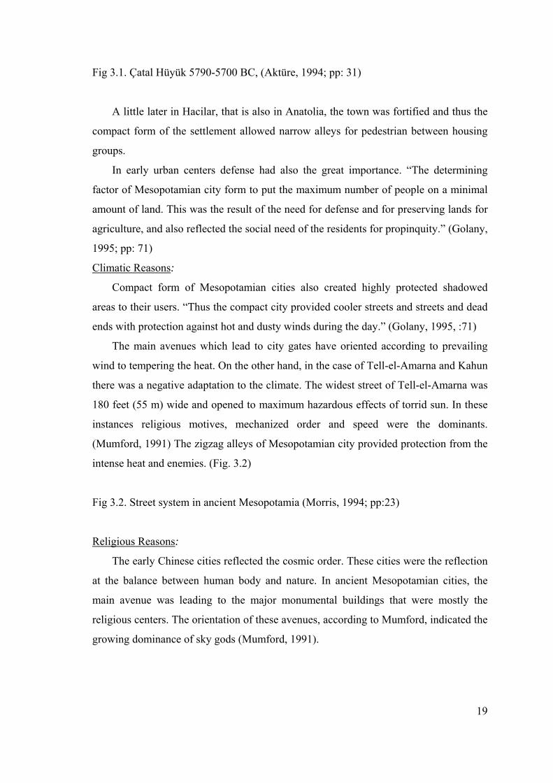
In Çatal Hüyük, a Bronze Age settlement in Anatolia, conglomerate of houses
constituted a complex system without streets due to the need of protection against
intruders and enemies. Outside walls of these tightly clamped housing groups did not
split with doors and windows and thus served as “defense walls”. The inhabitants had
reached their houses from the roofs. (Aktüre, 1994) (Fig. 3.1)
19
Fig 3.1. Çatal Hüyük 5790-5700 BC, (Aktüre, 1994; pp: 31)
A little later in Hacilar, that is also in Anatolia, the town was fortified and thus the
compact form of the settlement allowed narrow alleys for pedestrian between housing
groups.
In early urban centers defense had also the great importance. “The determining
factor of Mesopotamian city form to put the maximum number of people on a minimal
amount of land. This was the result of the need for defense and for preserving lands for
agriculture, and also reflected the social need of the residents for propinquity.” (Golany,
1995; pp: 71)
Climatic Reasons:
Compact form of Mesopotamian cities also created highly protected shadowed
areas to their users. “Thus the compact city provided cooler streets and streets and dead
ends with protection against hot and dusty winds during the day.” (Golany, 1995, :71)
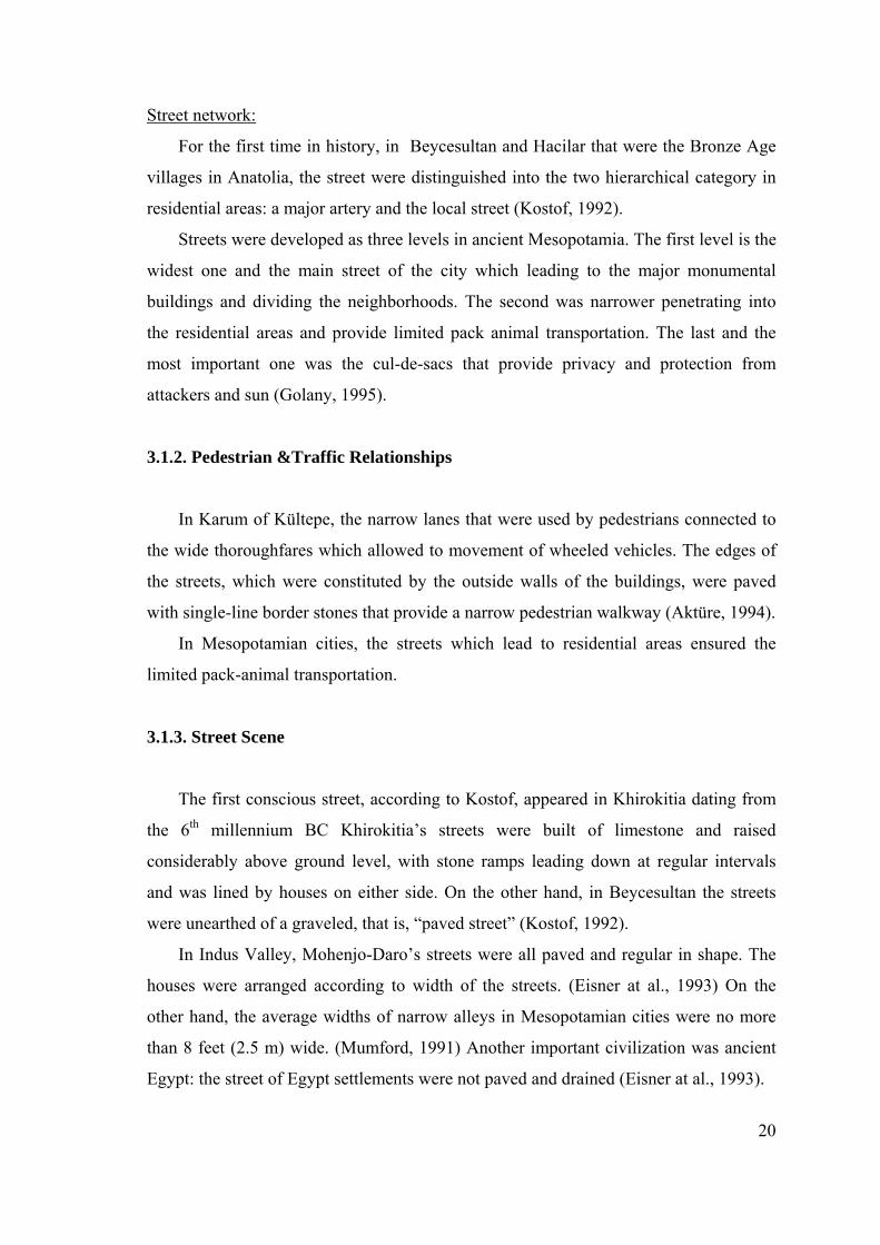
The main avenues which lead to city gates have oriented according to prevailing
wind to tempering the heat. On the other hand, in the case of Tell-el-Amarna and Kahun
there was a negative adaptation to the climate. The widest street of Tell-el-Amarna was
180 feet (55 m) wide and opened to maximum hazardous effects of torrid sun. In these
instances religious motives, mechanized order and speed were the dominants.
(Mumford, 1991) The zigzag alleys of Mesopotamian city provided protection from the
intense heat and enemies. (Fig. 3.2)
Fig 3.2. Street system in ancient Mesopotamia (Morris, 1994; pp:23)
Religious Reasons:
The early Chinese cities reflected the cosmic order. These cities were the reflection
at the balance between human body and nature. In ancient Mesopotamian cities, the
main avenue was leading to the major monumental buildings that were mostly the
religious centers. The orientation of these avenues, according to Mumford, indicated the
growing dominance of sky gods (Mumford, 1991).
20
Street network:
For the first time in history, in Beycesultan and Hacilar that were the Bronze Age
villages in Anatolia, the street were distinguished into the two hierarchical category in
residential areas: a major artery and the local street (Kostof, 1992).
Streets were developed as three levels in ancient Mesopotamia. The first level is the
widest one and the main street of the city which leading to the major monumental
buildings and dividing the neighborhoods. The second was narrower penetrating into
the residential areas and provide limited pack animal transportation. The last and the
most important one was the cul-de-sacs that provide privacy and protection from
attackers and sun (Golany, 1995).
3.1.2. Pedestrian &Traffic Relationships
In Karum of Kültepe, the narrow lanes that were used by pedestrians connected to
the wide thoroughfares which allowed to movement of wheeled vehicles. The edges of
the streets, which were constituted by the outside walls of the buildings, were paved
with single-line border stones that provide a narrow pedestrian walkway (Aktüre, 1994).
In Mesopotamian cities, the streets which lead to residential areas ensured the
limited pack-animal transportation.
3.1.3. Street Scene
The first conscious street, according to Kostof, appeared in Khirokitia dating from
the 6th millennium BC Khirokitia’s streets were built of limestone and raised
considerably above ground level, with stone ramps leading down at regular intervals
and was lined by houses on either side. On the other hand, in Beycesultan the streets
were unearthed of a graveled, that is, “paved street” (Kostof, 1992).
In Indus Valley, Mohenjo-Daro’s streets were all paved and regular in shape. The
houses were arranged according to width of the streets. (Eisner at al., 1993) On the
other hand, the average widths of narrow alleys in Mesopotamian cities were no more
than 8 feet (2.5 m) wide. (Mumford, 1991) Another important civilization was ancient
Egypt: the street of Egypt settlements were not paved and drained (Eisner at al., 1993).
21
The importance of privacy, associated with culture was affected the early
civilizations’ street scene. In Mesopotamia, ancient Greek and China, the family home
turned is back on the street and focused around an internal courtyard. Another
remarkable point related to street scene was the absence of street lighting. “Since the
streets of ancient cities were dark at night and did not ensure any entertainment for
citizens, people spent their times in the evenings at home, often on the rooftops”
(Golany, 1995, pp: 92).
3.2. The Classic City
Early Greek cities of Aegean were irregular in form. During the early years of
Athenian democracy in 5th century BC, Greek cities were naturally evolved. The
planned Greek city was seen in the latter part of the 5th century BC in Hippodamus’s
Miletus plan. Than some Greek cities in Aegean costs were laid out according to
systematic principals of gridiron urban form. (Eisner at al., 1993) Main urban form
determinants of these cities were the topography and climate. The Greek city had
clearly defined limits and compact in form.
The Romans were impressed by the Greek architecture and planning. There were
great engineers and aggressive city builders without purely aesthetic ideas as the Greeks
had. But they improved and modified some Greek forms.
There was a great hierarchical order between Roman towns that connected directly
to each other by provincial roads. This system was so efficient that “All roads leads to
Rome” derived from there. The networks of roads were located the important and
strategic military and trade activities. (Morris, 1994)
22
3.2.1. Street System & Network
Gridiron Street System:
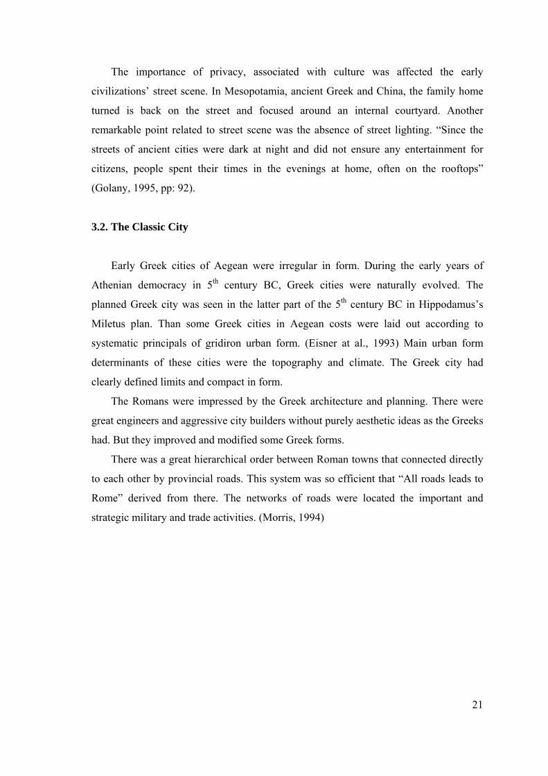
Greek street pattern have been influenced by Platon’s ideals and Euclidean
geometry and irregular shape of urban form was replaced by Hippodamus, architect
from Miletus, in the latter part of the 5th century BC.
He was been credited with the origination of the gridiron streets system. Actually it
was not a new invention of city planning. There were very early examples in ancient
Egypt, Mesopotamia and Indus Valley. However, he effectively adapted the gridiron
scheme to create a rational arrangement of buildings and circulation (Eisner at al., 1993)
(Fig. 3.3).
Fig 3.3. Hippodamus’s Miletus plan (Kostof, 1991; pp:106)
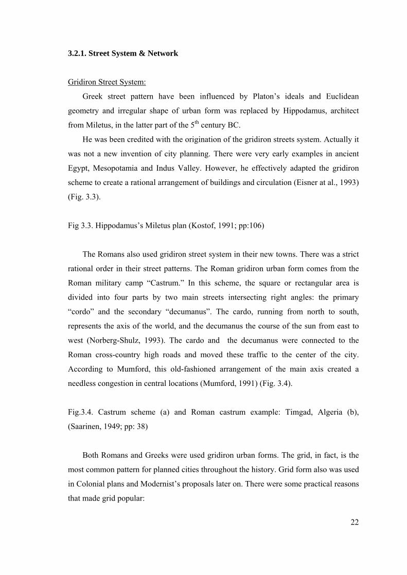
The Romans also used gridiron street system in their new towns. There was a strict
rational order in their street patterns. The Roman gridiron urban form comes from the
Roman military camp “Castrum.” In this scheme, the square or rectangular area is
divided into four parts by two main streets intersecting right angles: the primary
“cordo” and the secondary “decumanus”. The cardo, running from north to south,
represents the axis of the world, and the decumanus the course of the sun from east to
west (Norberg-Shulz, 1993). The cardo and the decumanus were connected to the
Roman cross-country high roads and moved these traffic to the center of the city.
According to Mumford, this old-fashioned arrangement of the main axis created a
needless congestion in central locations (Mumford, 1991) (Fig. 3.4).
Fig.3.4. Castrum scheme (a) and Roman castrum example: Timgad, Algeria (b),
(Saarinen, 1949; pp: 38)
Both Romans and Greeks were used gridiron urban forms. The grid, in fact, is the
most common pattern for planned cities throughout the history. Grid form also was used
in Colonial plans and Modernist’s proposals later on. There were some practical reasons
that made grid popular:
23
• First, the grid is systematic. It allows flexible and diverse system at planning. In all
gridiron forms the streets pattern is orthogonal that are the right angles rules and
street lines in both direction lie parallel to each other.
• Second, it is easy to laid out. Greek and Romans land surveyors used the device
called “groma” passes from Egyptians. In this system, as Kostof defines “one of the
lincals was used for sighting a main direction and the other to determine the direction
in the field at right angles to it” (Kostof, 1991; pp: 96).
• Third, it is expandable. Grid system allows expansion of towns and its quarters for
later developments within a same order. It also provides production of spaces within
a short period of time.
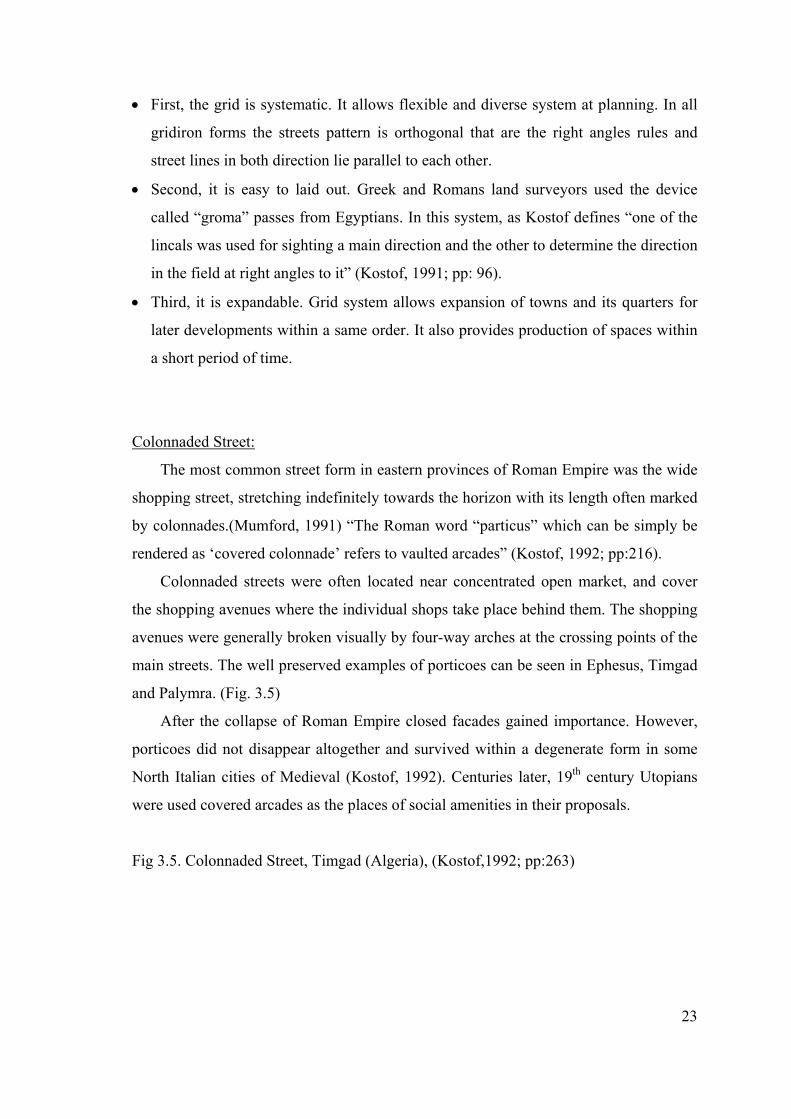
Colonnaded Street:
The most common street form in eastern provinces of Roman Empire was the wide
shopping street, stretching indefinitely towards the horizon with its length often marked
by colonnades.(Mumford, 1991) “The Roman word “particus” which can be simply be
rendered as ‘covered colonnade’ refers to vaulted arcades” (Kostof, 1992; pp:216).
Colonnaded streets were often located near concentrated open market, and cover
the shopping avenues where the individual shops take place behind them. The shopping
avenues were generally broken visually by four-way arches at the crossing points of the
main streets. The well preserved examples of porticoes can be seen in Ephesus, Timgad
and Palymra. (Fig. 3.5)
After the collapse of Roman Empire closed facades gained importance. However,
porticoes did not disappear altogether and survived within a degenerate form in some
North Italian cities of Medieval (Kostof, 1992). Centuries later, 19th century Utopians
were used covered arcades as the places of social amenities in their proposals.
Fig 3.5. Colonnaded Street, Timgad (Algeria), (Kostof,1992; pp:263)
24
3.2.2. Pedestrian & Traffic Relationships
The gridiron form of Greek streets sometimes created access problems.
“Superimposing the rigid geometrical form of the Hippodamus street system upon the
rugged topography of the sites occupied by most Greek cities, created numerous streets
so steep they could be negotiated only with steps” (Eisner at al., 1993; pp: 62). This
situation also created some problems to pedestrians while reaching to the important
public buildings located at the top of the settlement. In addition to this, transportation of
freights by wheeled vehicles was very few due to the steepy principal traffic streets.
In the Greek city, “the functional uses of buildings and public spaces were
recognized in the arrangements of streets. They provided for the circulation of people
and vehicles without interference with the orientation of dwellings or the assembly of
people in the market place”. (Eisner at al., 1993; pp: 61) Streets are the open public
spaces as agora and forum and mostly used by pedestrians rather than wheeled vehicles.
In Roman cities there were sidewalks protecting pedestrian from the wheeled
traffic. However, they had been forgotten until the late 17th century (Hass-Klau, 1990).
“The Roman word for sidewalk was “semita” refers to 3rd century BC” (Kostof,1992;
pp:213).
The street network was overloaded and congested due to the increase of population,
continual conflict between pedestrian and wheeled traffic became intolerable in Rome.
At last, traffic congestion became the subject of municipal regulation in the period of
Julius Caesar; in 1st century BC according to regulation, the wheeled traffic would not
enter the Rome between sunrise and sunset. However, the noise of these vehicles was
moved to the night. Later than, the numbers of the teams and loads of carts were
permitted to enter the city. Those regulations were applied to the new cities. But, their
orthogonal gridiron forms generated more traffic than the street network could cope
with (Mumford, 1991).
25
3.2.3. Street Scene
In ancient Greece, as in Mesopotamia and in the cities of Islam, inturned residences
were the dominant forms. The outer walls of houses lined the streets and created
privacy to their users. In these cases the determining factor is culture (Kostof, 1992).
The width of Roman roads varied from 8 feet (2.5 m) to 24 feet (7.5 m) wide on
parts of the great trunk highways, but generally the standard width was 15 feet (5 m)
(Mumford, 1991).
In the newer, smaller cities and as well as Rome street paving is widely applied,
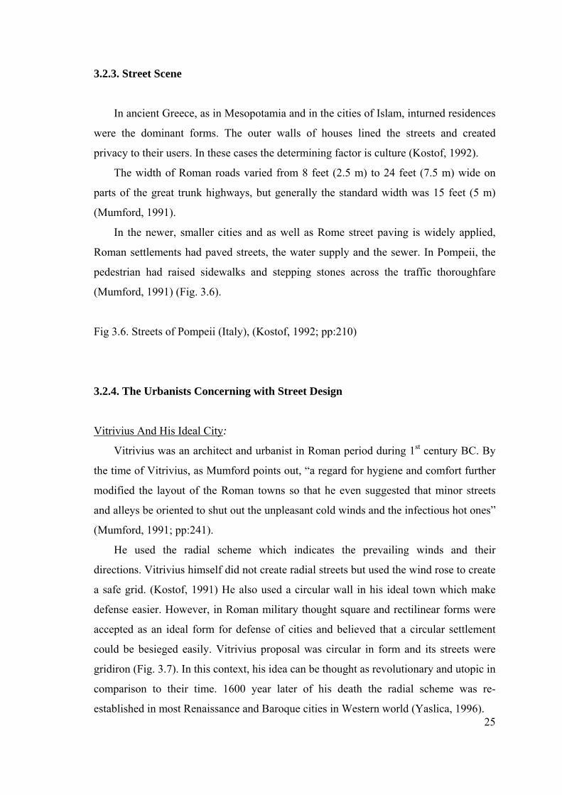
Roman settlements had paved streets, the water supply and the sewer. In Pompeii, the
pedestrian had raised sidewalks and stepping stones across the traffic thoroughfare
(Mumford, 1991) (Fig. 3.6).
Fig 3.6. Streets of Pompeii (Italy), (Kostof, 1992; pp:210)
3.2.4. The Urbanists Concerning with Street Design
Vitrivius And His Ideal City:
Vitrivius was an architect and urbanist in Roman period during 1st century BC. By
the time of Vitrivius, as Mumford points out, “a regard for hygiene and comfort further
modified the layout of the Roman towns so that he even suggested that minor streets
and alleys be oriented to shut out the unpleasant cold winds and the infectious hot ones”
(Mumford, 1991; pp:241).
He used the radial scheme which indicates the prevailing winds and their
directions. Vitrivius himself did not create radial streets but used the wind rose to create
a safe grid. (Kostof, 1991) He also used a circular wall in his ideal town which make
defense easier. However, in Roman military thought square and rectilinear forms were
accepted as an ideal form for defense of cities and believed that a circular settlement
could be besieged easily. Vitrivius proposal was circular in form and its streets were
gridiron (Fig. 3.7). In this context, his idea can be thought as revolutionary and utopic in
comparison to their time. 1600 year later of his death the radial scheme was re-
established in most Renaissance and Baroque cities in Western world (Yaslica, 1996).
26
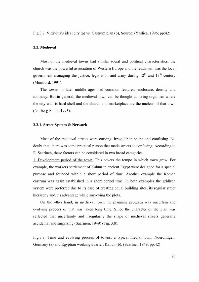
Fig.3.7. Vitrivius’s ideal city (a) vs. Castrum plan (b), Source: (Yaslica, 1996; pp:42)
3.3. Medieval
Most of the medieval towns had similar social and political characteristics: the
church was the powerful association of Western Europe and the feudalism was the local
government managing the justice, legislation and army during 12th and 13th century
(Mumford, 1991).
The towns in later middle ages had common features; enclosure, density and
intimacy. But in general, the medieval town can be thought as living organism where
the city wall is hard shell and the church and marketplace are the nucleus of that town
(Norberg-Shulz, 1993).
3.3.1. Street System & Network
Most of the medieval streets were curving, irregular in shape and confusing. No
doubt that, there was some practical reason that made streets so confusing. According to
E. Saarinen, these factors can be considered in two broad categories;
1. Development period of the town: This covers the tempo in which town grew. For
example, the workers settlement of Kahun in ancient Egypt were designed for a special
purpose and founded within a short period of time. Another example the Roman
castrum was again established in a short period time. In both examples the gridiron
system were preferred due to its ease of creating equal building sites, its regular street
hierarchy and, its advantage while surveying the plots.
On the other hand, in medieval town the planning program was uncertain and
evolving process of that was taken long time. Since the character of the plan was
reflected that uncertainty and irregularity the shape of medieval streets generally
accidental and surprising (Saarinen, 1949) (Fig. 3.8).
Fig.3.8. Time and evolving process of towns: a typical medial town, Noerdlingen,
Germany (a) and Egyptian working quarter, Kahun (b), (Saarinen,1949; pp:42)
27
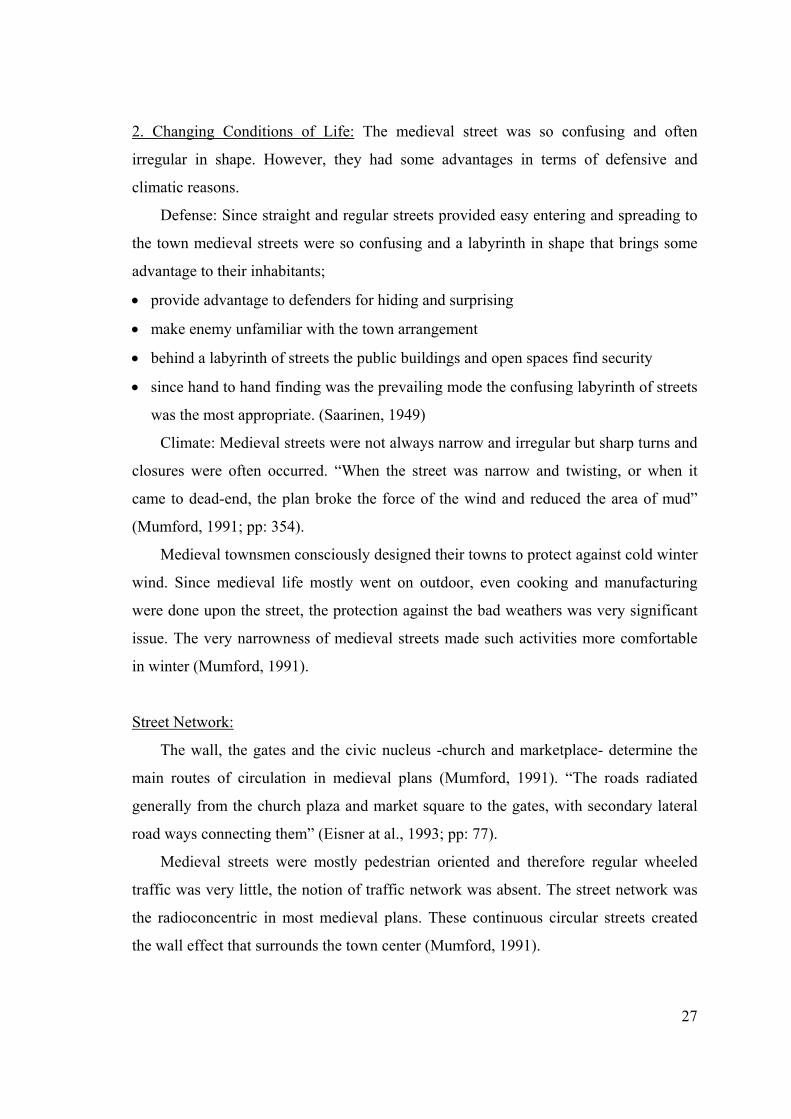
2. Changing Conditions of Life: The medieval street was so confusing and often
irregular in shape. However, they had some advantages in terms of defensive and
climatic reasons.
Defense: Since straight and regular streets provided easy entering and spreading to
the town medieval streets were so confusing and a labyrinth in shape that brings some
advantage to their inhabitants;
• provide advantage to defenders for hiding and surprising
• make enemy unfamiliar with the town arrangement
• behind a labyrinth of streets the public buildings and open spaces find security
• since hand to hand finding was the prevailing mode the confusing labyrinth of streets
was the most appropriate. (Saarinen, 1949)
Climate: Medieval streets were not always narrow and irregular but sharp turns and
closures were often occurred. “When the street was narrow and twisting, or when it
came to dead-end, the plan broke the force of the wind and reduced the area of mud”
(Mumford, 1991; pp: 354).
Medieval townsmen consciously designed their towns to protect against cold winter
wind. Since medieval life mostly went on outdoor, even cooking and manufacturing
were done upon the street, the protection against the bad weathers was very significant
issue. The very narrowness of medieval streets made such activities more comfortable
in winter (Mumford, 1991).
Street Network:
The wall, the gates and the civic nucleus -church and marketplace- determine the
main routes of circulation in medieval plans (Mumford, 1991). “The roads radiated
generally from the church plaza and market square to the gates, with secondary lateral
road ways connecting them” (Eisner at al., 1993; pp: 77).
Medieval streets were mostly pedestrian oriented and therefore regular wheeled
traffic was very little, the notion of traffic network was absent. The street network was
the radioconcentric in most medieval plans. These continuous circular streets created
the wall effect that surrounds the town center (Mumford, 1991).
28
3.3.2. Pedestrian & Traffic Relationships
In a medieval town, except a few main roads between the gates and the market
place, streets were used for pedestrian circulation rather than main traffic arteries.
Wheeled vehicles were generally absent from all but the main roadways (Eisner at al.,
1993).
In medieval towns, pedestrian needs were dominated. The urban fabric allowed
providing the intimate relationships and direct face- to- facing communication. Streets
were not designed to accommodate the wheeled vehicles and neither water pipes nor
sewage drains needed to be provided. Therefore, to follow nature’s contours while
passing the streets was more economical (Mumford, 1991).
As described previously, movement in medieval towns was largely on foot
However, in late medieval period wheeled traffic increased with the rise of mercantile
economy (Eisner at al., 1993).
Today contemporary city streets are threatened by the expansion of wheeled traffic.
In contrast to our times, medieval streets were in human scale, pedestrian friendly and
the line of communication for pedestrians.
3.3.3. Street Scene
The accepted image of medieval city was constituted by the narrow built-up streets
which provided walkers dynamic always changing and visually surprising 3-
dimensional forms. As discussed previously, this structure was the functional resultant
form of the need for defense and protection against the bad weathers. The short
approaches to the great buildings, the blocked vistas, increase the effect of verticality
and provided street scene was usually accidental (Morris, 1994).
According to Mumford (1991, pp.325), “throughout the middle ages there was a
tendency for buildings to encroach even further onto streets”. The one of the extreme
examples of these trend in medieval age was the “bridge streets” in which the houses
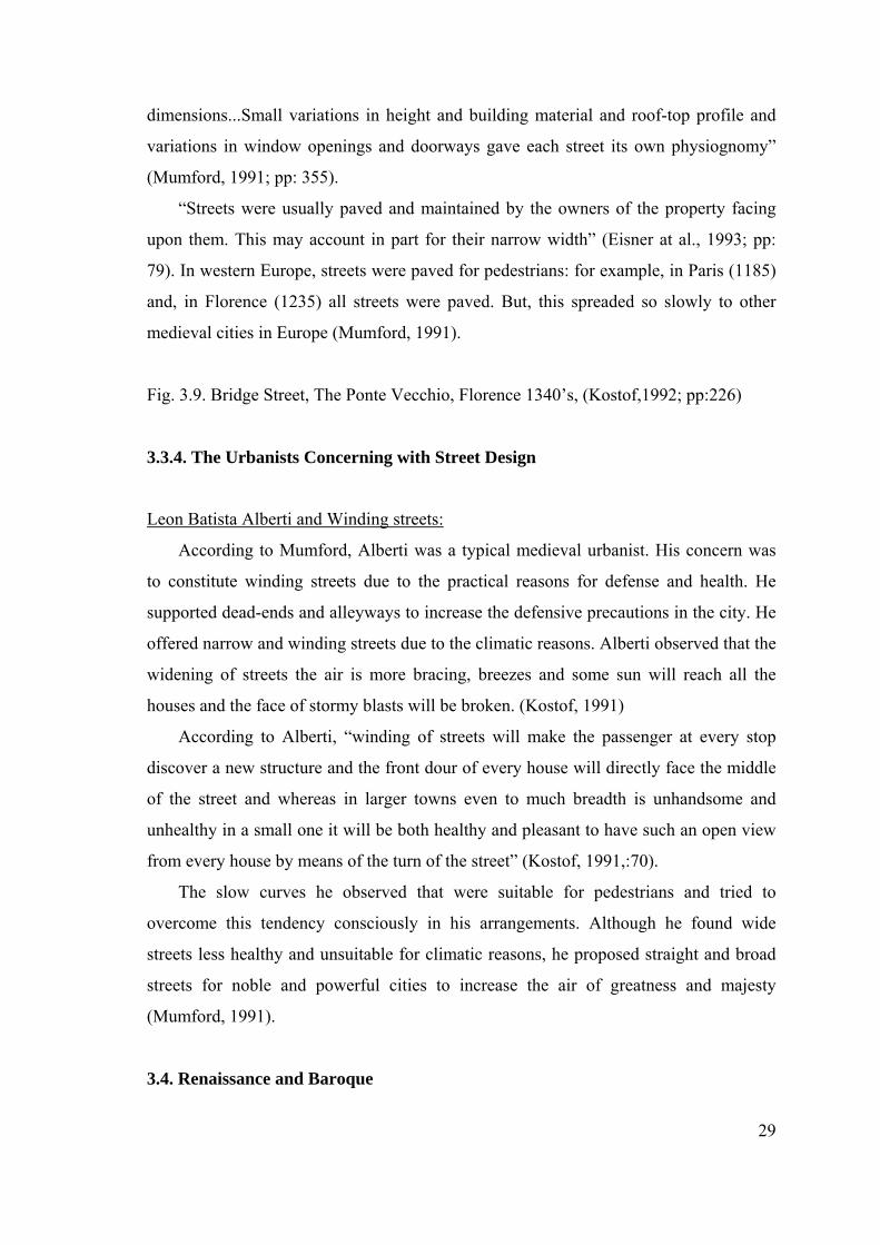
and shops lining the bridge (Kostof, 1992) (Fig. 3.9).
Due to the defensive considerations houses had guarded access on the ground floor
that served as domestic wall. (Mumford, 1991) “Thus mass and heights were important
symbolic attributes, the medieval builders tended to keep to modest human
29
dimensions...Small variations in height and building material and roof-top profile and
variations in window openings and doorways gave each street its own physiognomy”
(Mumford, 1991; pp: 355).
“Streets were usually paved and maintained by the owners of the property facing
upon them. This may account in part for their narrow width” (Eisner at al., 1993; pp:
79). In western Europe, streets were paved for pedestrians: for example, in Paris (1185)
and, in Florence (1235) all streets were paved. But, this spreaded so slowly to other
medieval cities in Europe (Mumford, 1991).
Fig. 3.9. Bridge Street, The Ponte Vecchio, Florence 1340’s, (Kostof,1992; pp:226)
3.3.4. The Urbanists Concerning with Street Design
Leon Batista Alberti and Winding streets:
According to Mumford, Alberti was a typical medieval urbanist. His concern was
to constitute winding streets due to the practical reasons for defense and health. He
supported dead-ends and alleyways to increase the defensive precautions in the city. He
offered narrow and winding streets due to the climatic reasons. Alberti observed that the
widening of streets the air is more bracing, breezes and some sun will reach all the
houses and the face of stormy blasts will be broken. (Kostof, 1991)
According to Alberti, “winding of streets will make the passenger at every stop
discover a new structure and the front dour of every house will directly face the middle
of the street and whereas in larger towns even to much breadth is unhandsome and
unhealthy in a small one it will be both healthy and pleasant to have such an open view
from every house by means of the turn of the street” (Kostof, 1991,:70).
The slow curves he observed that were suitable for pedestrians and tried to
overcome this tendency consciously in his arrangements. Although he found wide
streets less healthy and unsuitable for climatic reasons, he proposed straight and broad
streets for noble and powerful cities to increase the air of greatness and majesty
(Mumford, 1991).
3.4. Renaissance and Baroque
30
During the Renaissance there were several dominant aesthetic considerations which
were common in all countries in Europe:
First, there was a great importance of symmetry to create a balanced composition
with one more axial lines. Second, at the end of the major, straight streets to locate
monuments, obelisks or statues as a terminating element that closing to vistas had big
importance. Third, with the repetition of a basic elevational design, individual buildings
had created a sense of single, integrated architectural ensemble. The last was the
application of the perspective theory in the art that made street as a locus of 3-D design
considerations (Morris, 1994).
Baroque period had seen from 17th century to first half of the 18th in Europe,
especially in two important capitals: Rome and Paris. According to Norberg-Shulz,
baroque city started in Rome by Pope Sixtus V who applied a great program for
religious reasons. The idea of new monumental buildings which were interconnected by
a ring of boulevards and royal plazas was grown in Paris. These new ideas were
originated from the French garden architecture (Norberg-Shulz, 1986). However,
beyond these developments there were some social, economic and political reasons. The
transformation was occurred while realizing the baroque order of new life: “from
medieval localism to baroque centralism, from medieval uniformity to baroque
universality, and from absolutism of church to the absolutism of centralized power of
national state” (Mumford, 1991; pp: 398).
The basic attitudes and form of life of Baroque age can be summarized with such
terms; system, centralization, extension and movement. (Norberg-Shulz, 1986) On the
other hand, Baroque brought new forms: in art, perspective and anatomy; in
architecture, axial symmetry and formalistic repetition; and in city building, carefully
detailed geometrical plan (Mumford, 1991).
3.4.1. Street System and Network
In contrast to medieval street, baroque street pattern were regular and straight.
These changes in street system can be examined in the three main categories:
31
1. Need for Defense: The use of gunpowder changed all the military strategies. The fall
of Constantinople in 1453 encouraged the military consideration in the design of ideal
Renaissance city (Morris, 1994).
Another development related to ideal Renaissance city is the interpretations of the
works of Vitrivius. Vitrivuan theory generally applied in radial-concentric forms,
enclosed within an octagonal defensive wall and eight radial street lead out to the angle
towers rather than the gateways. This was the asterisk plan that was one of the most
important inventions of Renaissance and Baroque. In these plans, the radial, straight
street were scattered from the center and such a central location, artillery could
command every approach easily. The new orders of these ideal schemes dictated the
radiating streets and avenues that cutting impartially through old tangles or new
gridirons, moving towards the boundless horizon (Mumford, 1991).
2. Ideology of Rulers: “The straight street can direct the social and practical advantages
it passes into a discourse of ideology and with a suitable coding of architecture and
decoration it can import a powerful representational message” (Kostof, 1991).
The rulers of this age had different purposes while dictating their system. For
example, Pope Sixtus V’s urban renewal in Rome (1563) had religious reasons. On the
other hand, Napoleon III had military goals. The strong rulers of Baroque age forced the
military streets. According to Alberti, “military streets-viae militares- should be straight
to achieve maximum appearance of order and power on parade. It is necessary to
provide a body of soldiers either within an open square or a long unbroken avenue”
(Mumford, 1991; pp: 422).
3. Changing tempo in social and economic life: In comparison with medieval time, the
tempo in city life was so fast and irregular system of old historic quarters of the city
could not support the increasing number of wheeled traffic. To make the movement of
wheeled vehicles easier straightening and widening of streets in the age of absolutism
became necessary. The straight street also has a practical superiority, in that it connects
two points directly and so speeds up communication (Kostof, 1991).
With the growing concentration of people especially in capital cities crooked streets
and dark alleyways became the locus of crime. In order to provide some breathe for old
32
quarters, new city designers of this period demolished old houses and other structures
along crooked streets and built the straight street.
Street Network:
Renaissance street network was mostly based upon old medieval irregular streets
and alleyways. On the other hand, baroque street network had two new components:
avenue and boulevard.
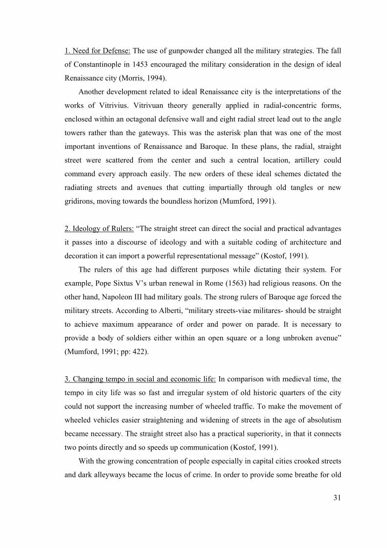
Avenue: The concept of ‘avenue’, according to Mumford, “is the most important
symbol and the main fact about the baroque city” (Mumford, 1991; pp: 421).
The origin of the avenue is largely rural. In 19th century French resources, avenues
were described as “lined with tall trees to distinguish them for the surrounding
landscape of leafy forests, low hedges and field of crops” (Kostof, 1991). They were
designed according to the axis of the important monuments and straight in shape. 16th
century version of this rural avenue became common all around the France with its
planting trees along the principal post roads. Surrounding of Paris was structured by a
network of radiating roads and geometrically ordered gardens after 17th century (Kostof,
1991).
Boulevard: The term ‘boulevard’ started to use as a boundary between city and
country. According to Morris, “the boulevard is the line of fortification itself but when
these converted into wide tree-lined streets. The designation of boulevard was kept
today the word means simply a broad tree-lined avenue” (Morris, 1994, pp: 201).
In 1670, with the destruction of the old city walls of Paris, these fortified sites
converted to the broad, elevated promenades, planted with double rows of trees and
accessible to carriages and pedestrians. These tree-lined ramparts -soon known as
boulevard- became a system of connected public promenades which designed to
facilitate the wheeled vehicles (Kostof, 1991) (Fig. 3.10).
Fig. 3.10. Baroque Avenues and Boulevards: (a) Paris, Boulevard du Temple, (b) Parc
Monceau , (Benevolo,1989; pp:69)
3.4.2. Pedestrian & Traffic Relationships
33
Military traffic was one of the most significant factor of the age beginning with
Alberti’s works and went on the boulevards of Haussmann in 19th century Paris. Grand
avenues of Baroque also accommodated the wheeled traffic the carts and wagons.
Increase in the number of carriages and coaches were the result of new technological
improvements in the wheel design. After that period wheeled traffic became urgent in
the 17th century. Though some protest were done by pedestrians against the existence of
disturbing wheeled traffic in the city streets, the new spirit in society was in favor of
rapid transportation.
Since crooked and narrow streets of medieval city were not designed for the access
of wheeled vehicles, the geometrically ordered uniform avenues appeared in the
baroque city. The movement of wheeled vehicles played a critical role in geometrizing
of space:
“Movement in straight line along an avenue was not merely economy but a special pleasure: it
brought into the city the stimulus and exhilaration of swift motion and it was possible to increase this
pleasure aesthetically by regular settings of buildings with regular facades and even cornices, whose
horizontal lines tended towards the same vanishing point as that towards which the carriage itself was
rolling. In walking the eye courts variety, but above this gait, movement demand repetition of units that
are to be seen” (Mumford, 1991, pp: 421).
The uniform avenues also brought movement and confusion to the quiet, self-
sufficient urban quarters. In contrast to centralized and spontaneous marketplace of
Medieval, in Baroque age commercial and entertainment activities started to take place
along these broad avenues.
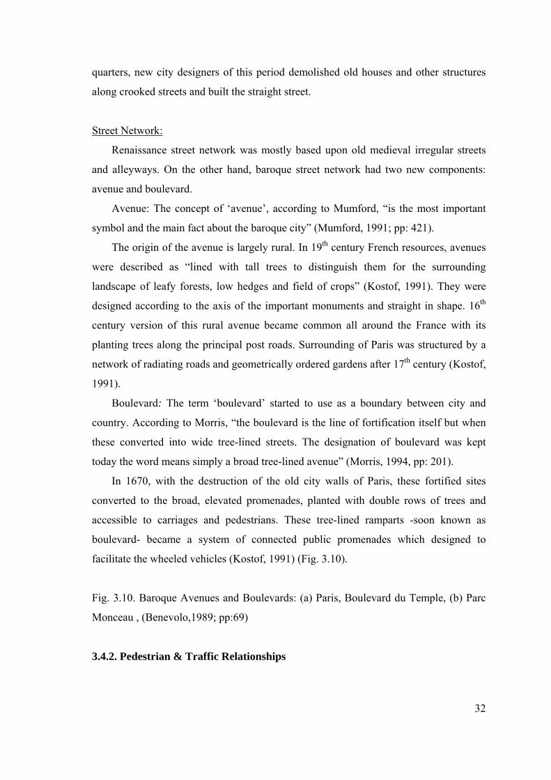
Pedestrian space was under pressure of increasing wheeled traffic, but a special
strip was provided in grand avenues for ordinary pedestrian: “the sidewalk”. On the
other hand, the early examples of separation of pedestrian ways from heavy traffic
arteries had seen in Leonardo da Vinci’s proposal for Milan. In his ideal scheme, to
provide multilevel separation of vehicular and pedestrian traffic special routes were
reserved for the heaviest goods traffic (Morris, 1994).
Fig.3.11. Leonardo’s proposal for Milan, (Kostof, 1992; pp: 237)
34
3.4.3. Street Scene
In renaissance street scene architectural landscape elements such as colonnades,
screens, terraces, trees and scrubs were applied in various forms by Renaissance
urbanists. (Morris, 1994) In renaissance period, since street scene dominated with old
medieval structures, the new buildings creating a rich complex order, after more
satisfying aesthetically than the uniform, single minded composition after 16th century.
According to Mumford, Uffuzi in Florence is one of the best examples of this visual
achievement with its straight, narrow and complex character (Mumford, 1991).
The symbol of new baroque street scene was the straight street, unbroken
horizontal roof-lines, the round arches and the repetition of uniform elements.
According to Alberti “streets will be rendered much more noble if the doors are built all
after the same model and the houses on each side stand on even line, and none higher
than the other” (Mumford, 1991; pp: 399). The use of straight lines and uniform
building lines brought the uniform motion and created monotonous street scene in
visually limitless avenues of Baroque age.
Another development which affects the Renaissance and Baroque street scene was
the innovation of perspective. “The study of perspective demolished the closed vista,
lengthened the distance towards the horizon and centered attention on the receding
planes, long before the wall was abolish as a feature of town planning” (Mumford,
1991; pp: 418). Perspective effects were emphasized in grand avenues by the location of
terminal features both architectural (monuments, uniform facades, repetition of
architectural elements) and sculptural (statues, fountains and obelisk) (Morris, 1994).
Street scene also reflected the ideological message of the despotic rulers. “All the
main avenues would lead to the palace, as often as not would close the vista. The axial
approach served as a spotlight to focus attention on the political power” (Mumford,
1991, pp: 445).
On the other hand, Baroque city can be thought as a big theater scene with its fine
avenues, monuments and squares. However, beyond this magnificent scene there was
no baroque order. There was only denied life of people who were suffering from the
despotic rulers. In this great theater, as Norberg-Shulz pointed out, everybody assigned
his role (Norberg-Shulz, 1993).
35
3.4.4. The Urbanists Concerning with Street Design
Renaissance urbanists had three main design components at their proposals: the
primary straight street, gridiron based districts, and enclosed spaces-squares and
piazzas. Another important design consideration was, of course, the need for defense.
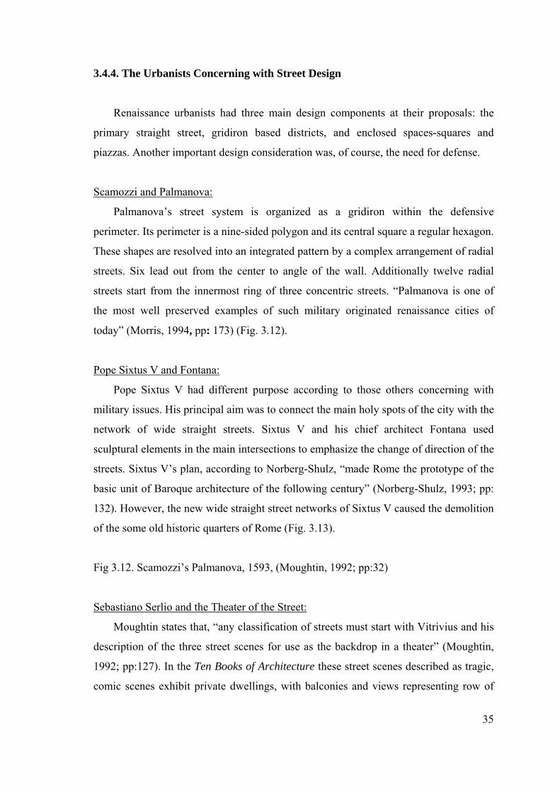
Scamozzi and Palmanova:
Palmanova’s street system is organized as a gridiron within the defensive
perimeter. Its perimeter is a nine-sided polygon and its central square a regular hexagon.
These shapes are resolved into an integrated pattern by a complex arrangement of radial
streets. Six lead out from the center to angle of the wall. Additionally twelve radial
streets start from the innermost ring of three concentric streets. “Palmanova is one of
the most well preserved examples of such military originated renaissance cities of
today” (Morris, 1994, pp: 173) (Fig. 3.12).
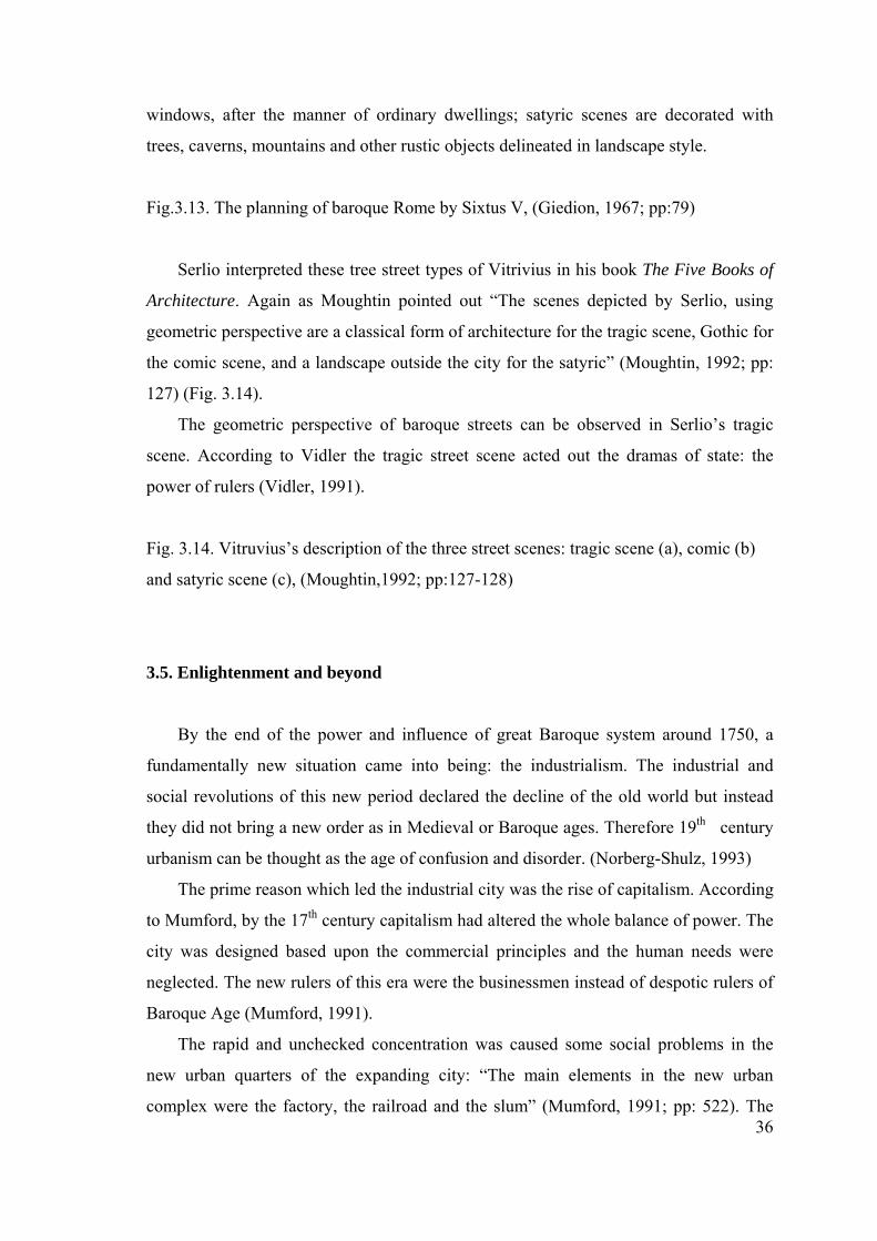
Pope Sixtus V and Fontana:
Pope Sixtus V had different purpose according to those others concerning with
military issues. His principal aim was to connect the main holy spots of the city with the
network of wide straight streets. Sixtus V and his chief architect Fontana used
sculptural elements in the main intersections to emphasize the change of direction of the
streets. Sixtus V’s plan, according to Norberg-Shulz, “made Rome the prototype of the
basic unit of Baroque architecture of the following century” (Norberg-Shulz, 1993; pp:
132). However, the new wide straight street networks of Sixtus V caused the demolition
of the some old historic quarters of Rome (Fig. 3.13).
Fig 3.12. Scamozzi’s Palmanova, 1593, (Moughtin, 1992; pp:32)
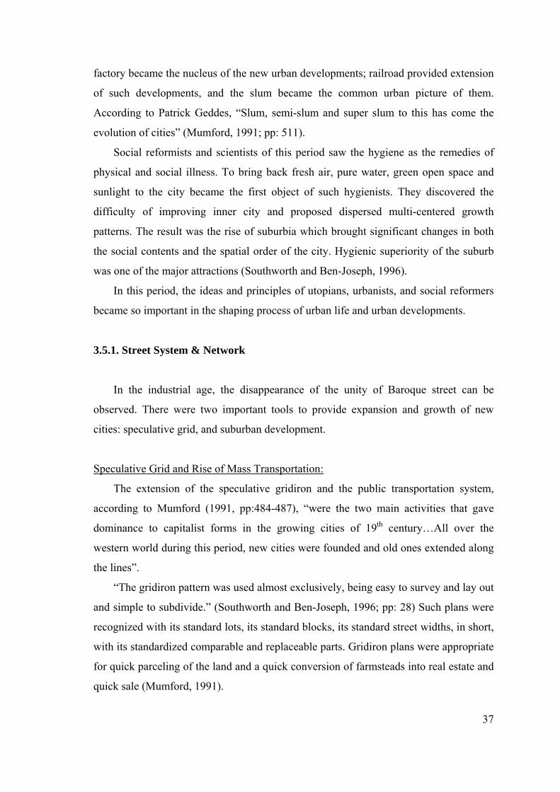
Sebastiano Serlio and the Theater of the Street:
Moughtin states that, “any classification of streets must start with Vitrivius and his
description of the three street scenes for use as the backdrop in a theater” (Moughtin,
1992; pp:127). In the Ten Books of Architecture these street scenes described as tragic,
comic scenes exhibit private dwellings, with balconies and views representing row of
36
windows, after the manner of ordinary dwellings; satyric scenes are decorated with
trees, caverns, mountains and other rustic objects delineated in landscape style.
Fig.3.13. The planning of baroque Rome by Sixtus V, (Giedion, 1967; pp:79)
Serlio interpreted these tree street types of Vitrivius in his book The Five Books of
Architecture. Again as Moughtin pointed out “The scenes depicted by Serlio, using
geometric perspective are a classical form of architecture for the tragic scene, Gothic for
the comic scene, and a landscape outside the city for the satyric” (Moughtin, 1992; pp:
127) (Fig. 3.14).
The geometric perspective of baroque streets can be observed in Serlio’s tragic
scene. According to Vidler the tragic street scene acted out the dramas of state: the
power of rulers (Vidler, 1991).
Fig. 3.14. Vitruvius’s description of the three street scenes: tragic scene (a), comic (b)
and satyric scene (c), (Moughtin,1992; pp:127-128)
3.5. Enlightenment and beyond
By the end of the power and influence of great Baroque system around 1750, a
fundamentally new situation came into being: the industrialism. The industrial and
social revolutions of this new period declared the decline of the old world but instead
they did not bring a new order as in Medieval or Baroque ages. Therefore 19th century
urbanism can be thought as the age of confusion and disorder. (Norberg-Shulz, 1993)
The prime reason which led the industrial city was the rise of capitalism. According
to Mumford, by the 17th century capitalism had altered the whole balance of power. The
city was designed based upon the commercial principles and the human needs were
neglected. The new rulers of this era were the businessmen instead of despotic rulers of
Baroque Age (Mumford, 1991).
The rapid and unchecked concentration was caused some social problems in the
new urban quarters of the expanding city: “The main elements in the new urban
complex were the factory, the railroad and the slum” (Mumford, 1991; pp: 522). The
37
factory became the nucleus of the new urban developments; railroad provided extension
of such developments, and the slum became the common urban picture of them.
According to Patrick Geddes, “Slum, semi-slum and super slum to this has come the
evolution of cities” (Mumford, 1991; pp: 511).
Social reformists and scientists of this period saw the hygiene as the remedies of
physical and social illness. To bring back fresh air, pure water, green open space and
sunlight to the city became the first object of such hygienists. They discovered the
difficulty of improving inner city and proposed dispersed multi-centered growth
patterns. The result was the rise of suburbia which brought significant changes in both
the social contents and the spatial order of the city. Hygienic superiority of the suburb
was one of the major attractions (Southworth and Ben-Joseph, 1996).
In this period, the ideas and principles of utopians, urbanists, and social reformers
became so important in the shaping process of urban life and urban developments.
3.5.1. Street System & Network
In the industrial age, the disappearance of the unity of Baroque street can be
observed. There were two important tools to provide expansion and growth of new
cities: speculative grid, and suburban development.
Speculative Grid and Rise of Mass Transportation:
The extension of the speculative gridiron and the public transportation system,
according to Mumford (1991, pp:484-487), “were the two main activities that gave
dominance to capitalist forms in the growing cities of 19th century…All over the
western world during this period, new cities were founded and old ones extended along
the lines”.
“The gridiron pattern was used almost exclusively, being easy to survey and lay out
and simple to subdivide.” (Southworth and Ben-Joseph, 1996; pp: 28) Such plans were
recognized with its standard lots, its standard blocks, its standard street widths, in short,
with its standardized comparable and replaceable parts. Gridiron plans were appropriate
for quick parceling of the land and a quick conversion of farmsteads into real estate and
quick sale (Mumford, 1991).
38
The grid also provided a framework which has infinitely expandable but which
allowed small increments of growth within a well understood pattern. The grid system
of city planning became the predominant urban form, especially in 19th century
America. Its efficiency and ease of surveying made the gridiron popular to speculators.
(Cohen, 1995) The New York Commissioners plan of 1811 was the typical one. The
plan of New York provided for a uniform network of streets, crossing at right angles.
The plan simply by placing buildings for activities of all kinds within the pre-arranged
network of the regular gridiron street. According to Commissioners report: “a city is
made up of houses and when streets cross at right angles houses are less expensive to
build and more convenient to live in” (Benevolo, 1989; pp: 214).
The mistake in this idea was the acceptance of houses as major function of the city.
Whereas the new industrial city constituted different kind of organizations and
functions. Functional differentiation between the residential, industrial, the commercial
and the civic quarters demanded blocks of different lengths and depths, with appropriate
streets and avenues to accord with their loads of traffic and their functionally different
building layouts (Mumford, 1991).
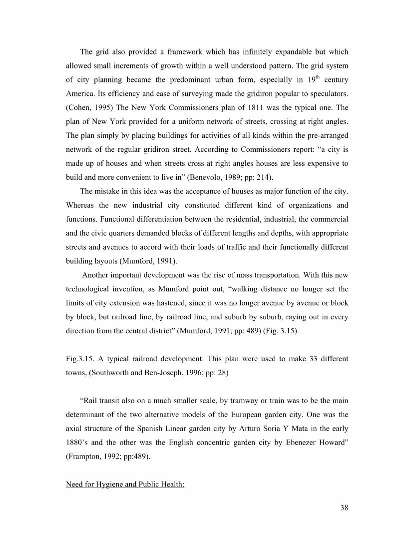
Another important development was the rise of mass transportation. With this new
technological invention, as Mumford point out, “walking distance no longer set the
limits of city extension was hastened, since it was no longer avenue by avenue or block
by block, but railroad line, by railroad line, and suburb by suburb, raying out in every
direction from the central district” (Mumford, 1991; pp: 489) (Fig. 3.15).
Fig.3.15. A typical railroad development: This plan were used to make 33 different
towns, (Southworth and Ben-Joseph, 1996; pp: 28)
“Rail transit also on a much smaller scale, by tramway or train was to be the main
determinant of the two alternative models of the European garden city. One was the
axial structure of the Spanish Linear garden city by Arturo Soria Y Mata in the early
1880’s and the other was the English concentric garden city by Ebenezer Howard”
(Frampton, 1992; pp:489).
Need for Hygiene and Public Health:
39
In Enlightenment period due to the overcrowding and insanitary conditions of the
industrial town prime concern was hygiene. This led the public health acts in diseased
urban centers, and produced some radical solutions: the surgical operations in old urban
quarters. On the other hand, escaping from the evil of industrial towns was realized in
the forms of suburbs.
Rise of Suburbia:
Due to the impacts of industrial revolution dead or infected parts, which called
slums, were appeared in the overpopulated and crammed cities. This situation led the
development of the idea of garden city and suburbanization. After 1830, the picturesque
suburbs were launched.
In suburban settlements, the planners abandoned the conventional terrace form
along a street grid. In contrast to this, the curvilinear street scheme was supported by
self contained villas in their own grounds (Kostof, 1991). “Following romantic
principles, the suburban house and plot and garden were deliberately deformalized. The
street avoided straight lines, even when no curves were given by nature” (Mumford,
1991; pp: 557). The curvilinear arrangements of streets were the most influential
features of such settlements.
Public Health Acts:
“In industrial city ordinances related to public health were usually spurred on by
the outbreak of epidemics... Congestion was perceived in terms of street width and the
overall height of flanking buildings. Narrow canyon like streets kept sunlight from
reaching ground level. The general remedies were to set height limits and to widen
streets correspondingly” (Kostof, 1992; pp: 205).
In 17th century especially in newly developed areas there was a great tendency for
wide and straight streets due to the increase in usage of coaches and health matters. On
the other hand, in 19th century crowded streets of old city quarters became the bed of
many diseases. In England in order to control these illness ‘bye-law street’ was
established with Public Health Acts between 1848 and 1866 (Kostof, 1992). “The vision
of wide, straight, paved streets entranced the authorities who saw it as the best solution
for the ills of their cities” (Southworth&Ben-Joseph, 1996; pp: 37). As planning
40
principle of such streets 17th century baroque uniformity and order were imposed (Fig.
3.16):
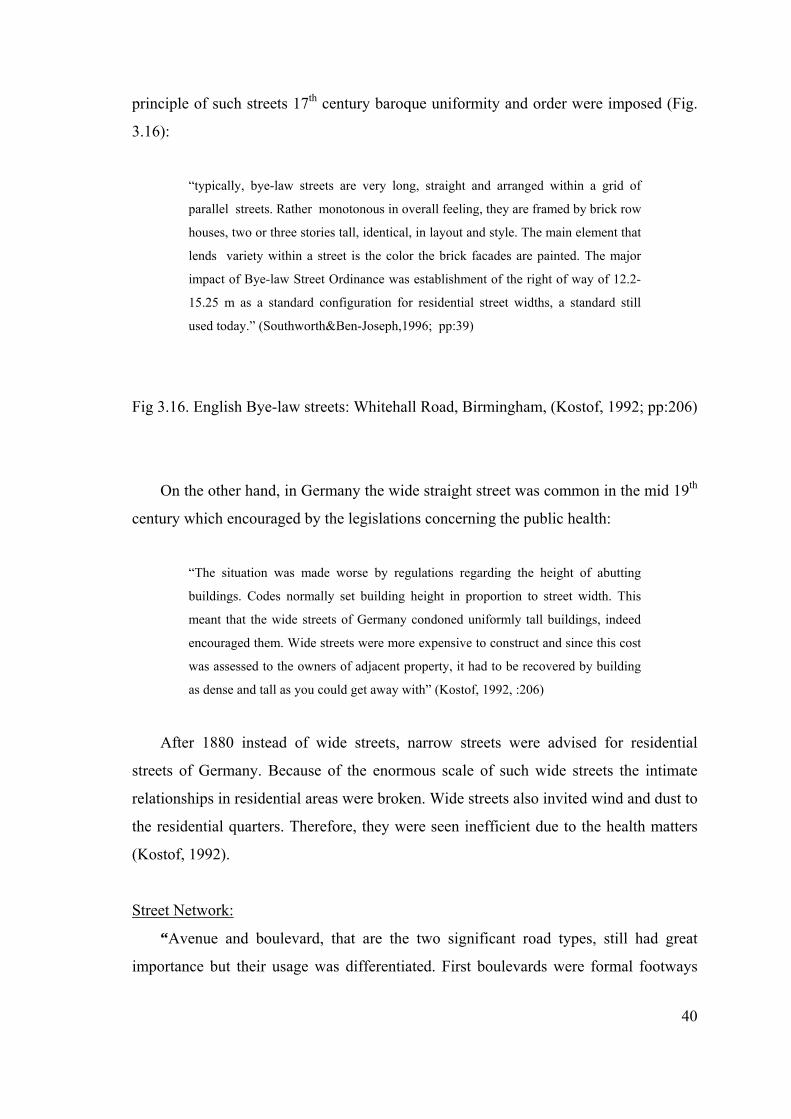
“typically, bye-law streets are very long, straight and arranged within a grid of
parallel streets. Rather monotonous in overall feeling, they are framed by brick row
houses, two or three stories tall, identical, in layout and style. The main element that
lends variety within a street is the color the brick facades are painted. The major
impact of Bye-law Street Ordinance was establishment of the right of way of 12.2-
15.25 m as a standard configuration for residential street widths, a standard still
used today.” (Southworth&Ben-Joseph,1996; pp:39)
Fig 3.16. English Bye-law streets: Whitehall Road, Birmingham, (Kostof, 1992; pp:206)
On the other hand, in Germany the wide straight street was common in the mid 19th
century which encouraged by the legislations concerning the public health:
“The situation was made worse by regulations regarding the height of abutting
buildings. Codes normally set building height in proportion to street width. This
meant that the wide streets of Germany condoned uniformly tall buildings, indeed
encouraged them. Wide streets were more expensive to construct and since this cost
was assessed to the owners of adjacent property, it had to be recovered by building
as dense and tall as you could get away with” (Kostof, 1992, :206)
After 1880 instead of wide streets, narrow streets were advised for residential
streets of Germany. Because of the enormous scale of such wide streets the intimate
relationships in residential areas were broken. Wide streets also invited wind and dust to
the residential quarters. Therefore, they were seen inefficient due to the health matters
(Kostof, 1992).
Street Network:
“Avenue and boulevard, that are the two significant road types, still had great
importance but their usage was differentiated. First boulevards were formal footways
41
designed for the promeneur” (Giedion, 1967, pp: 757). However, the 19th century
Haussmann boulevards were designed mainly the carrier of heavy traffic.
Distinction between the avenue and boulevard became uncertain after the second
half of 19th century:
“With the planted stretches of the old walls, the original boulevards, now within the
limits of the expanding cities. As early as the 1830’s the introduction of new design
features popularized in Great Britain, both the interior avenue and to the original
boulevards created a level of uniformity. These features included underground
storm drains and sewers and visible to the eye, paving, house numbering, mail
boxes and most important of all, sidewalks. The urban boulevard was divided into
three distinct strips. The sidewalks were shoppers and shopping, the break between
two functions” (Kostof, 1992; pp:254).
Although these large boulevards accommodate different kind of commercial and
entertainment facilities they were too large to provide intimate relationships and closed
vistas as in traditional streets. Boulevards also demolished the integrity and social
structure of the old quarters and neighborhoods (Kostof, 1991).
On the other hand, avenue and boulevard had different usage in America. Avenues
were primary traffic arteries and not encouraged for social activities and boulevards
were the green connectors of parks with the outer parts of town that were made popular
by F. L. Olmsted. In the American suburbs boulevards were used as parkways.
However, they transformed into traffic arteries by automobiles later on. But the origins
of our times boulevard was largely constituted by the time of Haussmann under the
brief autocracy of Napeleon III.
Haussmann Boulevards:
The reasons that made the rebuilding of Paris inevitable can be examined in three
main headings:
1. The ruler’s wishes: Napoleon III wished to make Paris the first great city of the
Industrial age. His insistence upon grand boulevards came from the desire of to increase
his popularity and make further revolutions more difficult. To replace the old mediaeval
streets with straight wide boulevards would be better for troop movements.
42
2. Traffic & Hygiene: Paris had reached about one million inhabitants under the rule of
Napoleon III. “The streets of medieval an Baroque, were inadequate for the traffic, the
old houses were ill suited to the sanitary requirements of the industrial city and the
concentration of functions and interests in the capital raised the price of building land to
such an extent that a radical transformation was inevitable.” (Benevelo, 1989; pp:67)
3. Bourgeoisie’s Pressures: The bourgeoisie’s wanted to reshape the city in its own
image to make its own business, residences and places of an entertainment the
monumental care of the city. (Kostof, 1991)
Haussmann principles and achievements for the city of Paris can be summarized
into three main headings;
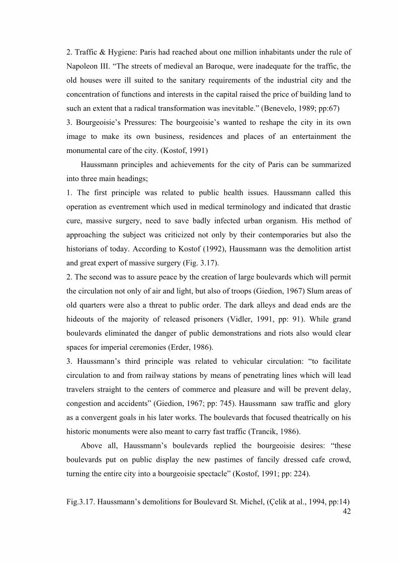
1. The first principle was related to public health issues. Haussmann called this
operation as eventrement which used in medical terminology and indicated that drastic
cure, massive surgery, need to save badly infected urban organism. His method of
approaching the subject was criticized not only by their contemporaries but also the
historians of today. According to Kostof (1992), Haussmann was the demolition artist
and great expert of massive surgery (Fig. 3.17).
2. The second was to assure peace by the creation of large boulevards which will permit
the circulation not only of air and light, but also of troops (Giedion, 1967) Slum areas of
old quarters were also a threat to public order. The dark alleys and dead ends are the
hideouts of the majority of released prisoners (Vidler, 1991, pp: 91). While grand
boulevards eliminated the danger of public demonstrations and riots also would clear
spaces for imperial ceremonies (Erder, 1986).
3. Haussmann’s third principle was related to vehicular circulation: “to facilitate
circulation to and from railway stations by means of penetrating lines which will lead
travelers straight to the centers of commerce and pleasure and will be prevent delay,
congestion and accidents” (Giedion, 1967; pp: 745). Haussmann saw traffic and glory
as a convergent goals in his later works. The boulevards that focused theatrically on his
historic monuments were also meant to carry fast traffic (Trancik, 1986).
Above all, Haussmann’s boulevards replied the bourgeoisie desires: “these
boulevards put on public display the new pastimes of fancily dressed cafe crowd,
turning the entire city into a bourgeoisie spectacle” (Kostof, 1991; pp: 224).
Fig.3.17. Haussmann’s demolitions for Boulevard St. Michel, (Çelik at al., 1994, pp:14)
43
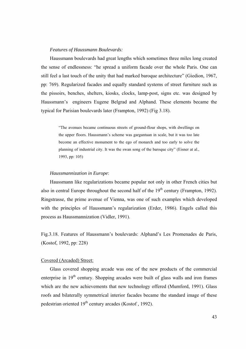
Features of Haussmann Boulevards:
Haussmann boulevards had great lengths which sometimes three miles long created
the sense of endlessness: “he spread a uniform facade over the whole Paris. One can
still feel a last touch of the unity that had marked baroque architecture” (Giedion, 1967,
pp: 769). Regularized facades and equally standard systems of street furniture such as
the pissoirs, benches, shelters, kiosks, clocks, lamp-post, signs etc. was designed by
Haussmann’s engineers Eugene Belgrad and Alphand. These elements became the
typical for Parisian boulevards later (Frampton, 1992) (Fig 3.18).
“The avenues became continuous streets of ground-flour shops, with dwellings on
the upper floors. Haussmann’s scheme was gargantuan in scale, but it was too late
become an effective monument to the ego of monarch and too early to solve the
planning of industrial city. It was the swan song of the baroque city” (Eisner at al.,
1993, pp: 105)
Haussmannization in Europe:
Haussmann like regularizations became popular not only in other French cities but
also in central Europe throughout the second half of the 19th century (Frampton, 1992).
Ringstrasse, the prime avenue of Vienna, was one of such examples which developed
with the principles of Haussmann’s regularization (Erder, 1986). Engels called this
process as Haussmannization (Vidler, 1991).
Fig.3.18. Features of Haussmann’s boulevards: Alphand’s Les Promenades de Paris,
(Kostof, 1992, pp: 228)
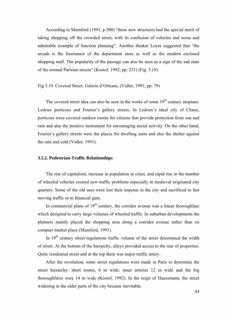
Covered (Arcaded) Street:
Glass covered shopping arcade was one of the new products of the commercial
enterprise in 19th century. Shopping arcades were built of glass walls and iron frames
which are the new achievements that new technology offered (Mumford, 1991). Glass
roofs and bilaterally symmetrical interior facades became the standard image of these
pedestrian oriented 19th century arcades (Kostof , 1992).
44
According to Mumford (1991, p.500) “these new structures had the special merit of
taking shopping off the crowded street, with its confusion of vehicles and noise and
admirable example of function planning”. Another thinker Loyer suggested that “the
arcade is the forerunner of the department store as well as the modern enclosed
shopping mall. The popularity of the passage can also be seen as a sign of the sad state
of the normal Parisian streets” (Kostof, 1992; pp: 231) (Fig. 3.19).
Fig.3.19. Covered Street: Galerie d’Orleans, (Vidler, 1991; pp: 79)
The covered street idea can also be seen in the works of some 19th century utopians:
Ledoux porticoes and Fourier’s gallery streets. In Ledoux’s ideal city of Chaux,
porticoes were covered outdoor rooms for citizens that provide protection from sun and
rain and also the positive instrument for encouraging social activity. On the other hand,
Fourier’s gallery streets were the places for dwelling units and also the shelter against
the rain and cold (Vidler, 1991).
3.5.2. Pedestrian-Traffic Relationships
The rise of capitalism, increase in population in cities, and rapid rise in the number
of wheeled vehicles created new traffic problems especially in medieval originated city
quarters. Some of the old uses were lost their impetus in the city and sacrificed to fast
moving traffic or to financial gain.
In commercial plans of 19th century, the corridor avenue was a linear thoroughfare
which designed to carry large volumes of wheeled traffic. In suburban developments the
planners mainly placed the shopping area along a corridor avenue rather than on
compact market place (Mumford, 1991).
In 19th century street regulations traffic volume of the street determined the width
of street. At the bottom of the hierarchy, alleys provided access to the rear of properties.
Quite residential street and at the top there was major traffic artery.
After the revolution, some street regulations were made in Paris to determine the
street hierarchy: short routes, 6 m wide; inner arteries 12 m wide and the big
thoroughfares were 14 m wide (Kostof, 1992). In the reign of Haussmann, the street
widening in the older parts of the city became inevitable.
45
On the other hand, sidewalk and street furniture for pedestrians came into being as
the typical features of the street after 18th century. In England, a series of improvements
in street design were introduced and popularized in the beginning of 18th century. These
achievements were the macadam paving, storm drains and sewers, piped water, house
numbering and sidewalks (Kostof, 1992). Again in England, as Southworth states, the
first modern street section was created in West Minister street improvement program
in 1765. “Streets were lowered and leveled and footway on each side were elevated
paved and defined by curbstones. The carriageway was paved with smooth granite
sloping to small drainage channels on both sides of the curbs” (Southworth & Ben-
Joseph, 1996; pp: 18). Such improvements in street design continued with Haussmann
boulevards in Paris and became universal.
The uses of overpasses and underpasses were brought a new dimension to the
pedestrian and traffic relationships in Olmsted and Vaux’s Central Park plan. This plan,
according to Mumford (1991, p.557), “was superior to any conventional two
dimensional city plan for, by using overpasses and underpasses wherever possible, it
provided four independent traffic networks: footways for pedestrians, bridlepaths for
horseback riders, carriage drivers for wheeled vehicles, and cross-town transverses for
city traffic”.
Industrial revolution involved new technological changes in street design.
However, these changes would be more radical in the motor age.
3.5.3. The Urbanists Concerning with Street Design
19th Century Utopians and Their Ideal Cities:
The utopian movements of the 19th century were a moral reaction to the
overcrowding and filth of the industrial age. Utopians; Ledoux, Laugier, Patte, Fourier,
Owen and others “thought of remedies they believed that the present irrational forms of
settlement would have to be replaced by the other completely different ones, dictated by
pure reasons, in fact, side by side with the real city they set the image of the ideal one.”
(Benevolo, 1989; pp: 148) “They had all in common an impulse to treat social ills with
large doses of lights, air and greenery” (Cohen, 1995).
According to Vidler, Morelly (1750) was the forerunner of the utopian socialist of
the early 19th century. He defends the geometrical arrangements of streets by means of
46
order (Vidler, 1991).According to him, if the regularity became dominant, confusion,
chaos and disorder would be eliminated. When the labyrinth shaped medieval streets
opened and straightened the social disorder would be dispelled. He saw the crooked
streets which accommodate criminals and rebelist as a danger for state (Vidler, 1991).
Laugier (1755), on the other hand, recommended the large avenues for the beauty
and order of cities. According to Laugier there were tree main elements that make city
magnificence; its entries, its streets and its buildings. Primary function of the street
according to him was to render communication easy and uncomfortable. In his time,
Paris was so tortuous, so full of bends and senseless angles and traveling from one
quarter of city to another with wheeled vehicles even by walking was almost
impossible. His remedy was clear: “Almost all the streets should be straightened and
enlarged. They should be extended as much as possible to eliminate too frequent
windings. New streets should be driven through all blocks that are longer than 600 feet
(180 m). At all intersections of streets the corners should be rounded: at all crossroads
there should be squares” (Vidler, 1991, p. 37). Laugier’s vision of limitless wide
avenues were realized later in the reign of Haussmann.
Patte’s (1765) approach was surgical. According to him “the city as a body in
varying states of sickness and disease and to be cured by arts of medicine. If the city
was to rebuilt in the image of man and the city was exhibiting severe problem, it was no
more than a sick body, to be diagnosed and treated as any man” (Vidler, 1991; pp:39).
Patte suggested that the streets are the distribution system of cities, if once they infected
they need to be a surgeon knife to defeat their illness.
Actually, the notion of city as an organism derived from the modern biology after
mid 17th century. The pairing of human organs thought as the elements of urban form.
Open spaces like squares are parks were the heart, pumping blood (traffic) through the
arteries (the street). (Kostof, 1991) Patte’s surgical treatments on the urban forms was
similar to the term ‘eventrement’ that used by Haussmann.
On the other hand, in Owen’s(1820) proposal the street eliminated or at least
transformed into a court (cloister). According to him “As court alleys lanes and streets
create unnecessary inconveniens are injurious to health and destructive to almost all the
natural comforts of human life, they will be excluded” (Vidler, 1991; pp: 60). He saw
the streets of industrial town as the place of every social ill and replace them with
cloisters in his ideal scheme.
47
Olmsted and American Suburbs:
The English picturesque tradition of design strongly influenced American architects
and urbanists. Frederick Law Olmsted was one of who criticized the gridiron system for
rectangular blocks with overcrowded row houses where poor living conditions went on.
“His rejection of grid and the adaptation of the curvilinear road and single family house
instead crowded row houses was the contrast with the mechanistic order of the urban
environment” (Southworth & Ben-Joseph, 1996, p.30). His remedial solution was the
suburban development far from the evil of industrial town. Then Olmsted and Vaux
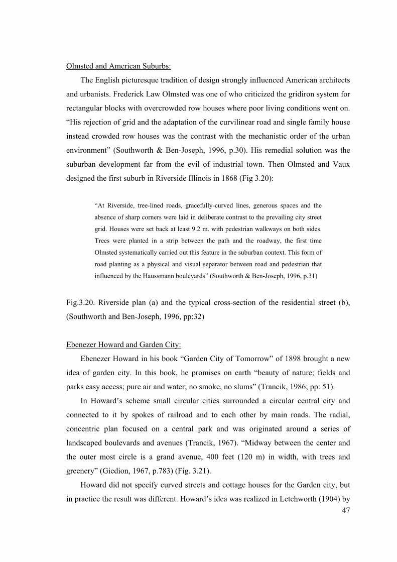
designed the first suburb in Riverside Illinois in 1868 (Fig 3.20):
“At Riverside, tree-lined roads, gracefully-curved lines, generous spaces and the
absence of sharp corners were laid in deliberate contrast to the prevailing city street
grid. Houses were set back at least 9.2 m. with pedestrian walkways on both sides.
Trees were planted in a strip between the path and the roadway, the first time
Olmsted systematically carried out this feature in the suburban context. This form of
road planting as a physical and visual separator between road and pedestrian that
influenced by the Haussmann boulevards” (Southworth & Ben-Joseph, 1996, p.31)
Fig.3.20. Riverside plan (a) and the typical cross-section of the residential street (b),
(Southworth and Ben-Joseph, 1996, pp:32)
Ebenezer Howard and Garden City:
Ebenezer Howard in his book “Garden City of Tomorrow” of 1898 brought a new
idea of garden city. In this book, he promises on earth “beauty of nature; fields and
parks easy access; pure air and water; no smoke, no slums” (Trancik, 1986; pp: 51).
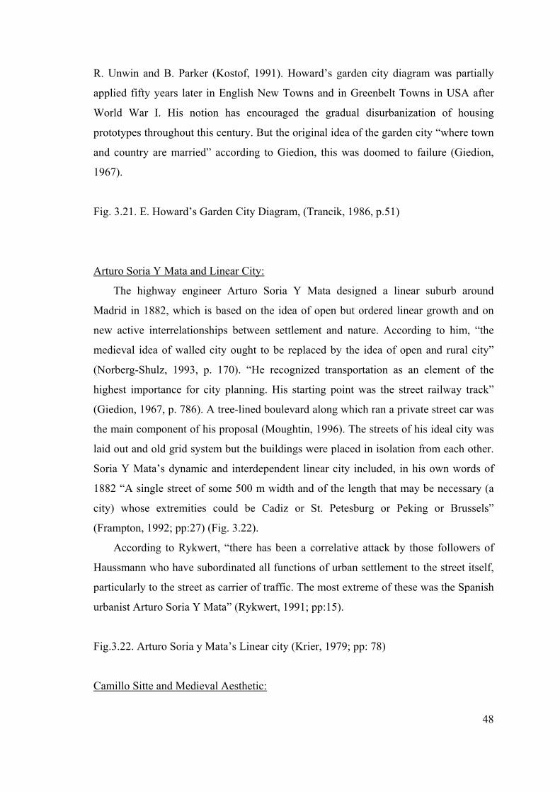
In Howard’s scheme small circular cities surrounded a circular central city and
connected to it by spokes of railroad and to each other by main roads. The radial,
concentric plan focused on a central park and was originated around a series of
landscaped boulevards and avenues (Trancik, 1967). “Midway between the center and
the outer most circle is a grand avenue, 400 feet (120 m) in width, with trees and
greenery” (Giedion, 1967, p.783) (Fig. 3.21).
Howard did not specify curved streets and cottage houses for the Garden city, but
in practice the result was different. Howard’s idea was realized in Letchworth (1904) by
48
R. Unwin and B. Parker (Kostof, 1991). Howard’s garden city diagram was partially
applied fifty years later in English New Towns and in Greenbelt Towns in USA after
World War I. His notion has encouraged the gradual disurbanization of housing
prototypes throughout this century. But the original idea of the garden city “where town
and country are married” according to Giedion, this was doomed to failure (Giedion,
1967).
Fig. 3.21. E. Howard’s Garden City Diagram, (Trancik, 1986, p.51)
Arturo Soria Y Mata and Linear City:
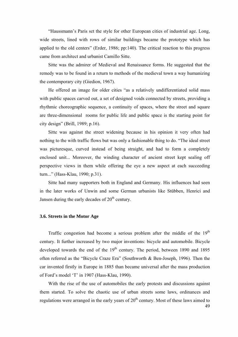
The highway engineer Arturo Soria Y Mata designed a linear suburb around
Madrid in 1882, which is based on the idea of open but ordered linear growth and on
new active interrelationships between settlement and nature. According to him, “the
medieval idea of walled city ought to be replaced by the idea of open and rural city”
(Norberg-Shulz, 1993, p. 170). “He recognized transportation as an element of the
highest importance for city planning. His starting point was the street railway track”
(Giedion, 1967, p. 786). A tree-lined boulevard along which ran a private street car was
the main component of his proposal (Moughtin, 1996). The streets of his ideal city was
laid out and old grid system but the buildings were placed in isolation from each other.
Soria Y Mata’s dynamic and interdependent linear city included, in his own words of
1882 “A single street of some 500 m width and of the length that may be necessary (a
city) whose extremities could be Cadiz or St. Petesburg or Peking or Brussels”
(Frampton, 1992; pp:27) (Fig. 3.22).
According to Rykwert, “there has been a correlative attack by those followers of
Haussmann who have subordinated all functions of urban settlement to the street itself,
particularly to the street as carrier of traffic. The most extreme of these was the Spanish
urbanist Arturo Soria Y Mata” (Rykwert, 1991; pp:15).
Fig.3.22. Arturo Soria y Mata’s Linear city (Krier, 1979; pp: 78)
Camillo Sitte and Medieval Aesthetic:
49
“Haussmann’s Paris set the style for other European cities of industrial age. Long,
wide streets, lined with rows of similar buildings became the prototype which has
applied to the old centers” (Erder, 1986; pp:140). The critical reaction to this progress
came from architect and urbanist Camillo Sitte.
Sitte was the admirer of Medieval and Renaissance forms. He suggested that the
remedy was to be found in a return to methods of the medieval town a way humanizing
the contemporary city (Giedion, 1967).
He offered an image for older cities “as a relatively undifferentiated solid mass
with public spaces carved out, a set of designed voids connected by streets, providing a
rhythmic choreographic sequence, a continuity of spaces, where the street and square
are three-dimensional rooms for public life and public space is the starting point for
city design” (Brill, 1989; p.16).
Sitte was against the street widening because in his opinion it very often had
nothing to the with traffic flows but was only a fashionable thing to do. “The ideal street
was picturesque, curved instead of being straight, and had to form a completely
enclosed unit... Moreover, the winding character of ancient street kept sealing off
perspective views in them while offering the eye a new aspect at each succeeding
turn...” (Hass-Klau, 1990; p.31).
Sitte had many supporters both in England and Germany. His influences had seen
in the later works of Unwin and some German urbanists like Stübben, Henrici and
Jansen during the early decades of 20th century.
3.6. Streets in the Motor Age
Traffic congestion had become a serious problem after the middle of the 19th
century. It further increased by two major inventions: bicycle and automobile. Bicycle
developed towards the end of the 19th century. The period, between 1890 and 1895
often referred as the “Bicycle Craze Era” (Southworth & Ben-Joseph, 1996). Then the
car invented firstly in Europe in 1885 than became universal after the mass production
of Ford’s model ‘T’ in 1907 (Hass-Klau, 1990).
With the rise of the use of automobiles the early protests and discussions against
them started. To solve the chaotic use of urban streets some laws, ordinances and
regulations were arranged in the early years of 20th century. Most of these laws aimed to
50
limit the development of the automobile. However, invasion of automobile completely
changed the economic, social, and political structure of modern society (Southworth &
Ben-Joseph, 1996).
Automobile impacts upon built-up environment were so destructive. Its use
changed the road design and its storage changed the design of the houses. Automobile
became the powerful tool of urban extension, decentralization and social alienation.
Futurists celebrated the advent of automobile: “A roaring car, ratting along like a
machine gun is more beautiful than the winged victory of Samothrace” (Kostof, 1985,
p. 720).
The rapid rise in number of car-ownership involved better roads which allow the
comfortable movement of the cars. Asphalt, the all-purpose street cover, became
standard in Europe and United States after 1885 (Kostof, 1992). Better roads brought
faster and advanced automobile design, also higher road construction standards.
To eliminate the chaotic street space in urban areas after 1920’s many familiar
traffic signs today were created. But for many planners traffic regulation was not the
solution of the future demands of traffic. New ideas came from utopians’ projects which
were the early responses of the demand of the motor vehicles. No doubt that, street
layouts and road building became the essence of planning and development and a
determining factor in shaping the pattern of the environment.
In order to regulate the pedestrians and traffic relationships early solutions of
separation of traffic modes were adapted in utopians’ plans for large cities in Europe.
Majority of these utopic projects included the separation of pedestrian areas and motor
traffic routes. One of the first plans, in terms of relieving street congestion, were the
underground railways in England in the latter part of 19th century. However, these
projects were too expensive to construct (Hass-Klau, 1990).
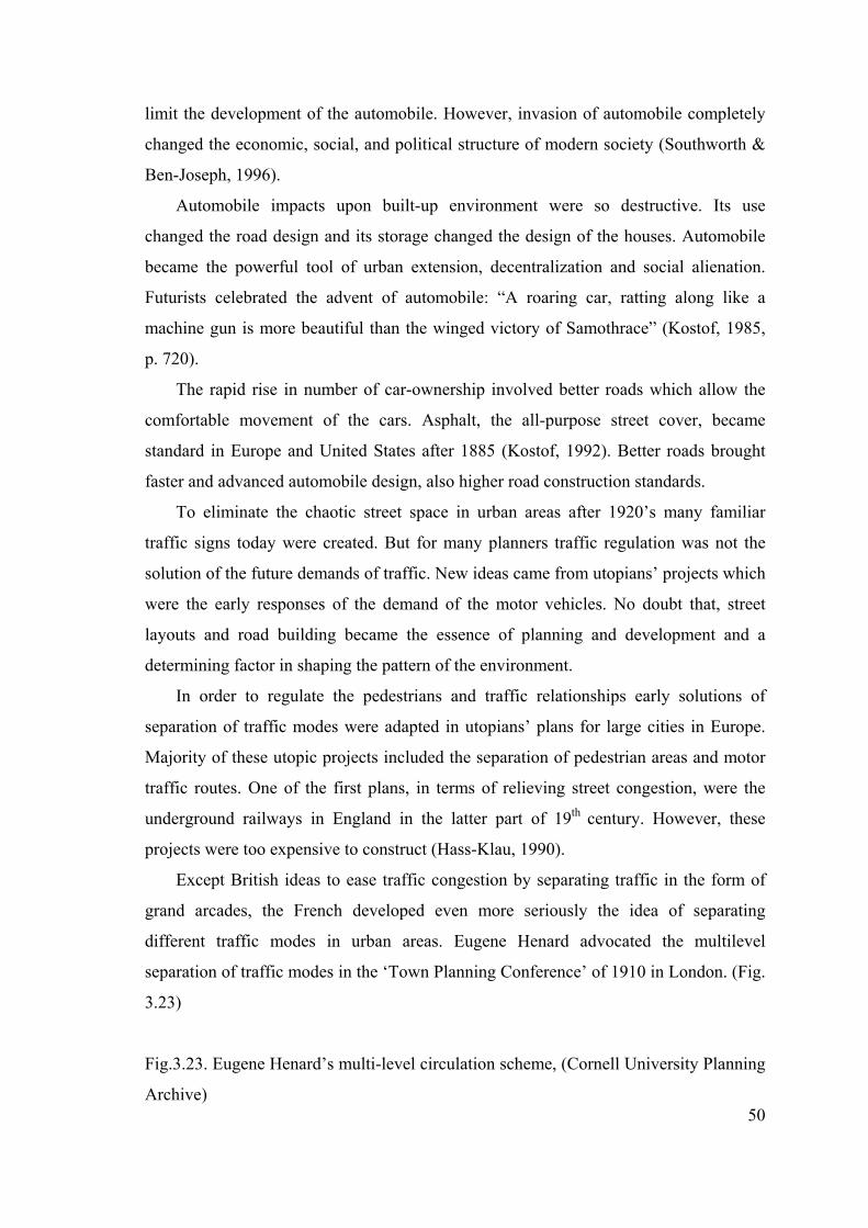
Except British ideas to ease traffic congestion by separating traffic in the form of
grand arcades, the French developed even more seriously the idea of separating
different traffic modes in urban areas. Eugene Henard advocated the multilevel
separation of traffic modes in the ‘Town Planning Conference’ of 1910 in London. (Fig.
3.23)
Fig.3.23. Eugene Henard’s multi-level circulation scheme, (Cornell University Planning
Archive)
51
In his point of view it would be possible to have three or four superimposed
platforms according to the level of traffic flows. The French idea of separating transport
modes into different levels was used in particular during and after 1920’s by various
designers but significantly by Le Corbusier (Hass-Klau, 1990).
3.6.1. Street Design in 20th Century
The twentieth century has seen the development and widespread acceptance of two
major city design manifestos: Garden City Movement and Charter of Athens. According
to A.B. Jacobs both were in large measure responses to the building excesses and
resultant foul living conditions of the 19th century industrial city. The Garden City
Movement became the models of suburban development that emphasized central green
areas rather than streets as the means of achieving face-to-face communication and
buildings well set back, if possible, divorced from streets. On the other hand, in the
Charter of Athens (1933) the rejection of streets as places for people and for the making
and expression of community was even stronger in favor of efficiency, technology and
speed. Public health was also one of the most important concerns of Modernist. ‘The
city in the park’ notion made streets unnecessary and orientation to street was seen as a
fundamental wrong (Jacobs, 1993).
3.6.1.1. Garden City Movement
Howard’s and Sitte’s ideas became the starting point for various architects and
planners of 20th century. Unwin and Parker of England, Stein and Wright of United
States and Stübben and Goecke of Germany became the forerunners of garden city
manifesto.
British Garden City Movement and Raymond Unwin&Berry Parker:
Unwin and Parker saw the Classical English Village as a model for a community
against the inhuman living conditions of industrial city. Village’s green, groups of
52
houses and long village street surrounded with clusters of cottages attracted them (Hass-
Klau, 1990).
Unwin found his architectural inspiration in the German town planning principles
of Stübben and especially the writings of Camillo Sitte. Unwin and Parker also
influenced the ideas of Ebenezer Howard. Howard’s statements of “the marriage of
town and country” attempted to realize in their design for Hampstead Garden Suburb.
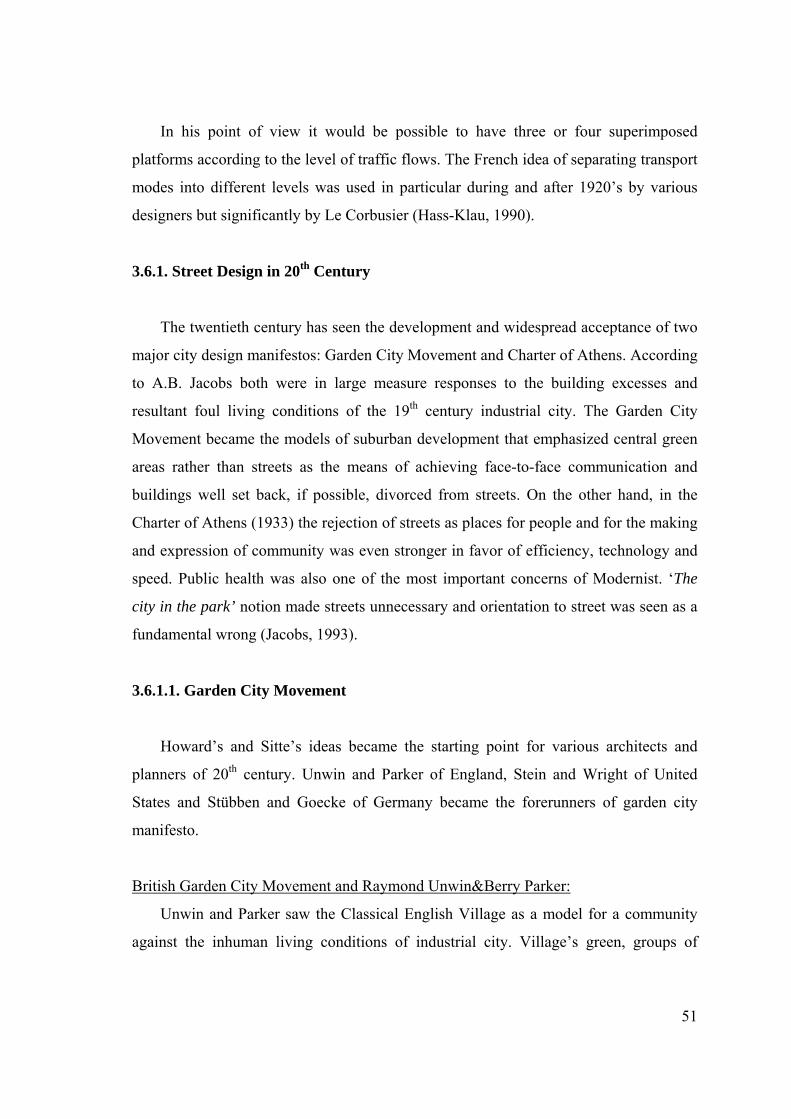
Also Parker and Unwin won the competition to design the first Garden City:
Letchworth (1904) (Southworth&Ben-Joseph, 1996). According Kostof, Letchworth
explored the possibility of a marriage between formal and informal planning, but with
clumsy results (Kostof, 1992) (Fig.3.24).
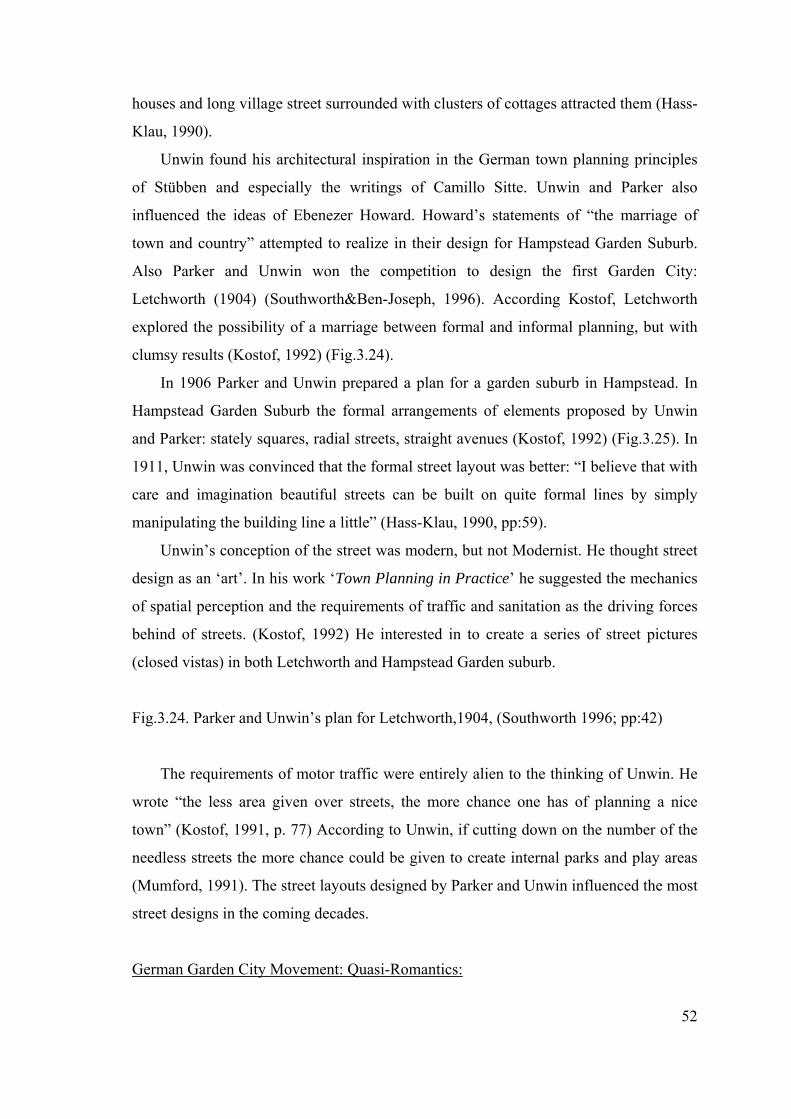
In 1906 Parker and Unwin prepared a plan for a garden suburb in Hampstead. In
Hampstead Garden Suburb the formal arrangements of elements proposed by Unwin
and Parker: stately squares, radial streets, straight avenues (Kostof, 1992) (Fig.3.25). In
1911, Unwin was convinced that the formal street layout was better: “I believe that with
care and imagination beautiful streets can be built on quite formal lines by simply
manipulating the building line a little” (Hass-Klau, 1990, pp:59).
Unwin’s conception of the street was modern, but not Modernist. He thought street
design as an ‘art’. In his work ‘Town Planning in Practice’ he suggested the mechanics
of spatial perception and the requirements of traffic and sanitation as the driving forces
behind of streets. (Kostof, 1992) He interested in to create a series of street pictures
(closed vistas) in both Letchworth and Hampstead Garden suburb.
Fig.3.24. Parker and Unwin’s plan for Letchworth,1904, (Southworth 1996; pp:42)
The requirements of motor traffic were entirely alien to the thinking of Unwin. He
wrote “the less area given over streets, the more chance one has of planning a nice
town” (Kostof, 1991, p. 77) According to Unwin, if cutting down on the number of the
needless streets the more chance could be given to create internal parks and play areas
(Mumford, 1991). The street layouts designed by Parker and Unwin influenced the most
street designs in the coming decades.
German Garden City Movement: Quasi-Romantics:
53
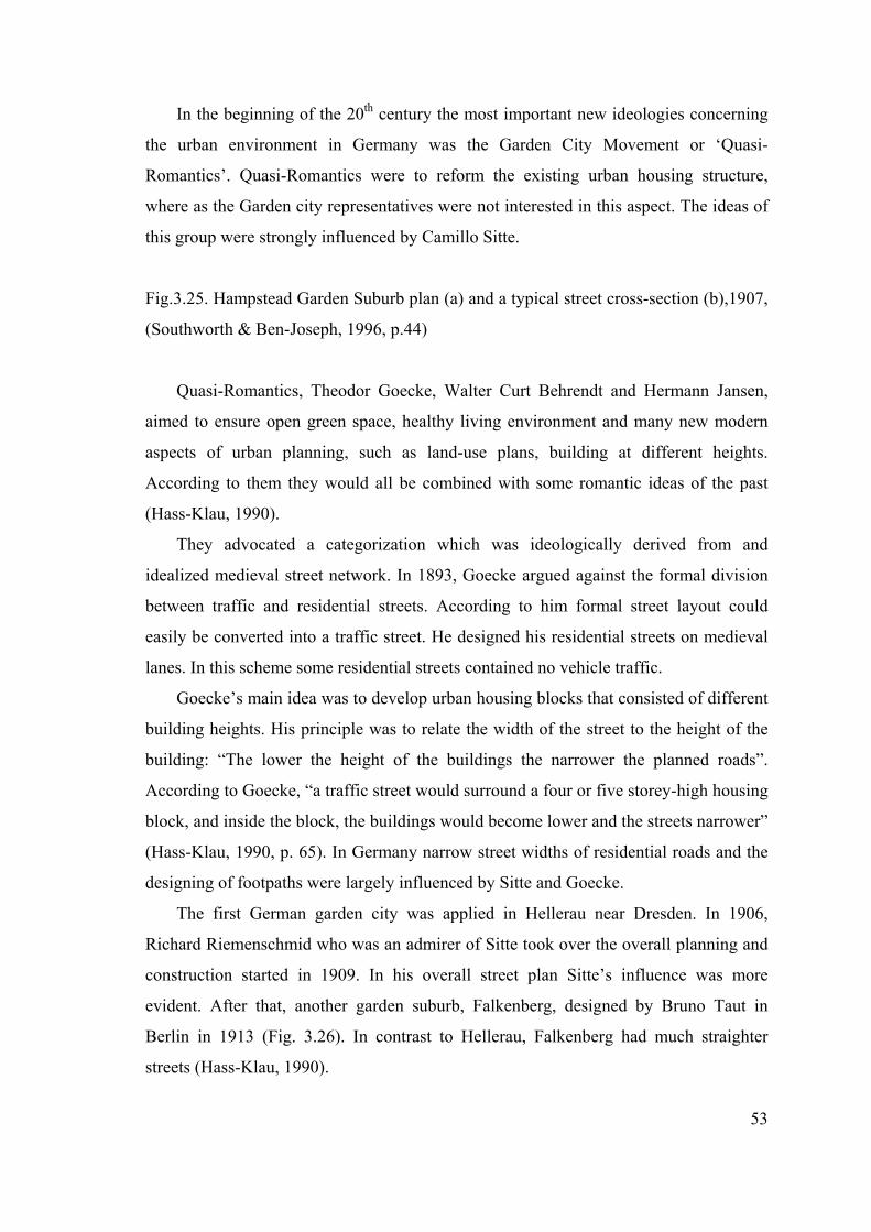
In the beginning of the 20th century the most important new ideologies concerning
the urban environment in Germany was the Garden City Movement or ‘Quasi-
Romantics’. Quasi-Romantics were to reform the existing urban housing structure,
where as the Garden city representatives were not interested in this aspect. The ideas of
this group were strongly influenced by Camillo Sitte.
Fig.3.25. Hampstead Garden Suburb plan (a) and a typical street cross-section (b),1907,
(Southworth & Ben-Joseph, 1996, p.44)
Quasi-Romantics, Theodor Goecke, Walter Curt Behrendt and Hermann Jansen,
aimed to ensure open green space, healthy living environment and many new modern
aspects of urban planning, such as land-use plans, building at different heights.
According to them they would all be combined with some romantic ideas of the past
(Hass-Klau, 1990).
They advocated a categorization which was ideologically derived from and
idealized medieval street network. In 1893, Goecke argued against the formal division
between traffic and residential streets. According to him formal street layout could
easily be converted into a traffic street. He designed his residential streets on medieval
lanes. In this scheme some residential streets contained no vehicle traffic.
Goecke’s main idea was to develop urban housing blocks that consisted of different
building heights. His principle was to relate the width of the street to the height of the
building: “The lower the height of the buildings the narrower the planned roads”.
According to Goecke, “a traffic street would surround a four or five storey-high housing
block, and inside the block, the buildings would become lower and the streets narrower”
(Hass-Klau, 1990, p. 65). In Germany narrow street widths of residential roads and the
designing of footpaths were largely influenced by Sitte and Goecke.
The first German garden city was applied in Hellerau near Dresden. In 1906,
Richard Riemenschmid who was an admirer of Sitte took over the overall planning and
construction started in 1909. In his overall street plan Sitte’s influence was more
evident. After that, another garden suburb, Falkenberg, designed by Bruno Taut in
Berlin in 1913 (Fig. 3.26). In contrast to Hellerau, Falkenberg had much straighter
streets (Hass-Klau, 1990).
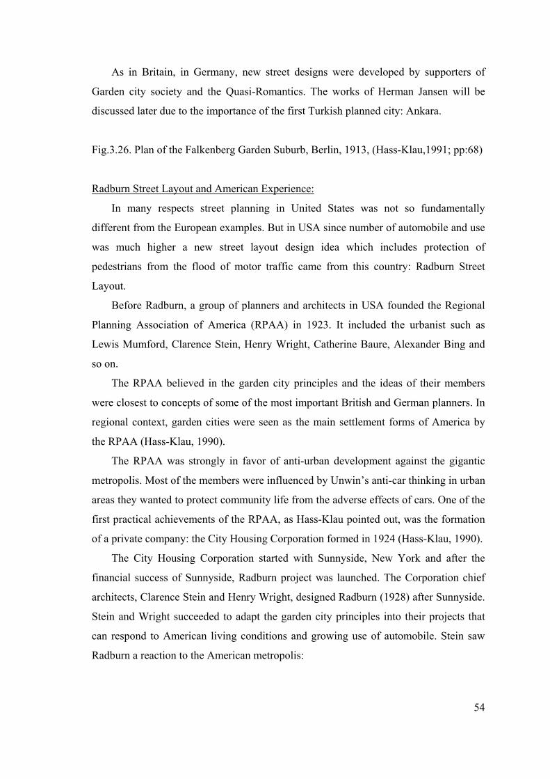
54
As in Britain, in Germany, new street designs were developed by supporters of
Garden city society and the Quasi-Romantics. The works of Herman Jansen will be
discussed later due to the importance of the first Turkish planned city: Ankara.
Fig.3.26. Plan of the Falkenberg Garden Suburb, Berlin, 1913, (Hass-Klau,1991; pp:68)
Radburn Street Layout and American Experience:
In many respects street planning in United States was not so fundamentally
different from the European examples. But in USA since number of automobile and use
was much higher a new street layout design idea which includes protection of
pedestrians from the flood of motor traffic came from this country: Radburn Street
Layout.
Before Radburn, a group of planners and architects in USA founded the Regional
Planning Association of America (RPAA) in 1923. It included the urbanist such as
Lewis Mumford, Clarence Stein, Henry Wright, Catherine Baure, Alexander Bing and
so on.
The RPAA believed in the garden city principles and the ideas of their members
were closest to concepts of some of the most important British and German planners. In
regional context, garden cities were seen as the main settlement forms of America by
the RPAA (Hass-Klau, 1990).
The RPAA was strongly in favor of anti-urban development against the gigantic
metropolis. Most of the members were influenced by Unwin’s anti-car thinking in urban
areas they wanted to protect community life from the adverse effects of cars. One of the
first practical achievements of the RPAA, as Hass-Klau pointed out, was the formation
of a private company: the City Housing Corporation formed in 1924 (Hass-Klau, 1990).
The City Housing Corporation started with Sunnyside, New York and after the
financial success of Sunnyside, Radburn project was launched. The Corporation chief
architects, Clarence Stein and Henry Wright, designed Radburn (1928) after Sunnyside.
Stein and Wright succeeded to adapt the garden city principles into their projects that
can respond to American living conditions and growing use of automobile. Stein saw
Radburn a reaction to the American metropolis:
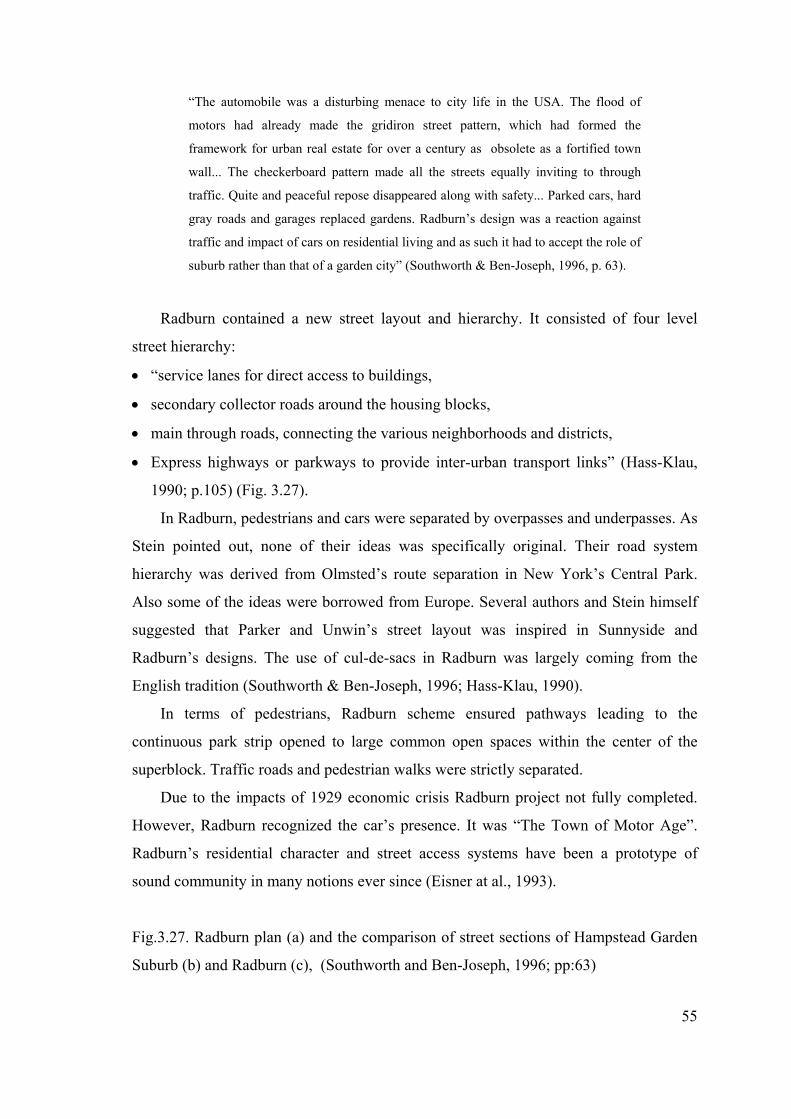
55
“The automobile was a disturbing menace to city life in the USA. The flood of
motors had already made the gridiron street pattern, which had formed the
framework for urban real estate for over a century as obsolete as a fortified town
wall... The checkerboard pattern made all the streets equally inviting to through
traffic. Quite and peaceful repose disappeared along with safety... Parked cars, hard
gray roads and garages replaced gardens. Radburn’s design was a reaction against
traffic and impact of cars on residential living and as such it had to accept the role of
suburb rather than that of a garden city” (Southworth & Ben-Joseph, 1996, p. 63).
Radburn contained a new street layout and hierarchy. It consisted of four level
street hierarchy:
• “service lanes for direct access to buildings,
• secondary collector roads around the housing blocks,
• main through roads, connecting the various neighborhoods and districts,
• Express highways or parkways to provide inter-urban transport links” (Hass-Klau,
1990; p.105) (Fig. 3.27).
In Radburn, pedestrians and cars were separated by overpasses and underpasses. As
Stein pointed out, none of their ideas was specifically original. Their road system
hierarchy was derived from Olmsted’s route separation in New York’s Central Park.
Also some of the ideas were borrowed from Europe. Several authors and Stein himself
suggested that Parker and Unwin’s street layout was inspired in Sunnyside and
Radburn’s designs. The use of cul-de-sacs in Radburn was largely coming from the
English tradition (Southworth & Ben-Joseph, 1996; Hass-Klau, 1990).
In terms of pedestrians, Radburn scheme ensured pathways leading to the
continuous park strip opened to large common open spaces within the center of the
superblock. Traffic roads and pedestrian walks were strictly separated.
Due to the impacts of 1929 economic crisis Radburn project not fully completed.
However, Radburn recognized the car’s presence. It was “The Town of Motor Age”.
Radburn’s residential character and street access systems have been a prototype of
sound community in many notions ever since (Eisner at al., 1993).
Fig.3.27. Radburn plan (a) and the comparison of street sections of Hampstead Garden
Suburb (b) and Radburn (c), (Southworth and Ben-Joseph, 1996; pp:63)
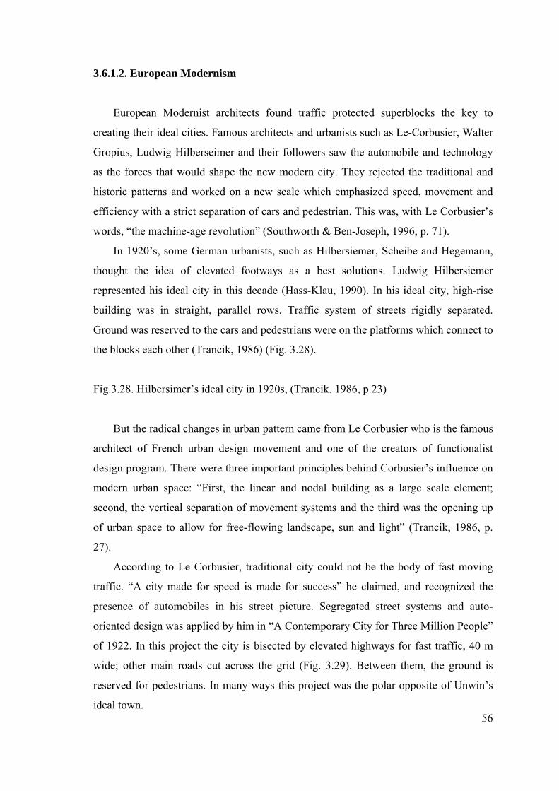
56
3.6.1.2. European Modernism
European Modernist architects found traffic protected superblocks the key to
creating their ideal cities. Famous architects and urbanists such as Le-Corbusier, Walter
Gropius, Ludwig Hilberseimer and their followers saw the automobile and technology
as the forces that would shape the new modern city. They rejected the traditional and
historic patterns and worked on a new scale which emphasized speed, movement and
efficiency with a strict separation of cars and pedestrian. This was, with Le Corbusier’s
words, “the machine-age revolution” (Southworth & Ben-Joseph, 1996, p. 71).
In 1920’s, some German urbanists, such as Hilbersiemer, Scheibe and Hegemann,
thought the idea of elevated footways as a best solutions. Ludwig Hilbersiemer
represented his ideal city in this decade (Hass-Klau, 1990). In his ideal city, high-rise
building was in straight, parallel rows. Traffic system of streets rigidly separated.
Ground was reserved to the cars and pedestrians were on the platforms which connect to
the blocks each other (Trancik, 1986) (Fig. 3.28).
Fig.3.28. Hilbersimer’s ideal city in 1920s, (Trancik, 1986, p.23)
But the radical changes in urban pattern came from Le Corbusier who is the famous
architect of French urban design movement and one of the creators of functionalist
design program. There were three important principles behind Corbusier’s influence on
modern urban space: “First, the linear and nodal building as a large scale element;
second, the vertical separation of movement systems and the third was the opening up
of urban space to allow for free-flowing landscape, sun and light” (Trancik, 1986, p.
27).
According to Le Corbusier, traditional city could not be the body of fast moving
traffic. “A city made for speed is made for success” he claimed, and recognized the
presence of automobiles in his street picture. Segregated street systems and auto-
oriented design was applied by him in “A Contemporary City for Three Million People”
of 1922. In this project the city is bisected by elevated highways for fast traffic, 40 m
wide; other main roads cut across the grid (Fig. 3.29). Between them, the ground is
reserved for pedestrians. In many ways this project was the polar opposite of Unwin’s
ideal town.
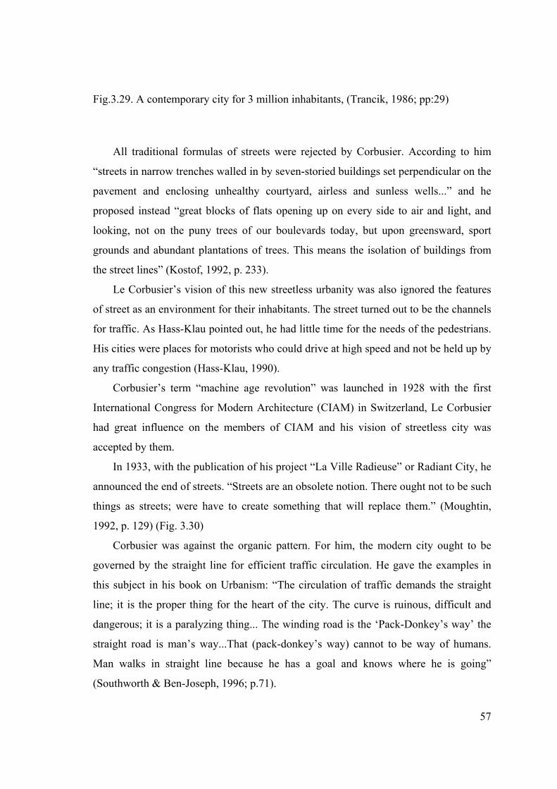
57
Fig.3.29. A contemporary city for 3 million inhabitants, (Trancik, 1986; pp:29)
All traditional formulas of streets were rejected by Corbusier. According to him
“streets in narrow trenches walled in by seven-storied buildings set perpendicular on the
pavement and enclosing unhealthy courtyard, airless and sunless wells...” and he
proposed instead “great blocks of flats opening up on every side to air and light, and
looking, not on the puny trees of our boulevards today, but upon greensward, sport
grounds and abundant plantations of trees. This means the isolation of buildings from
the street lines” (Kostof, 1992, p. 233).
Le Corbusier’s vision of this new streetless urbanity was also ignored the features
of street as an environment for their inhabitants. The street turned out to be the channels
for traffic. As Hass-Klau pointed out, he had little time for the needs of the pedestrians.
His cities were places for motorists who could drive at high speed and not be held up by
any traffic congestion (Hass-Klau, 1990).
Corbusier’s term “machine age revolution” was launched in 1928 with the first
International Congress for Modern Architecture (CIAM) in Switzerland, Le Corbusier
had great influence on the members of CIAM and his vision of streetless city was
accepted by them.
In 1933, with the publication of his project “La Ville Radieuse” or Radiant City, he
announced the end of streets. “Streets are an obsolete notion. There ought not to be such
things as streets; were have to create something that will replace them.” (Moughtin,
1992, p. 129) (Fig. 3.30)
Corbusier was against the organic pattern. For him, the modern city ought to be
governed by the straight line for efficient traffic circulation. He gave the examples in
this subject in his book on Urbanism: “The circulation of traffic demands the straight
line; it is the proper thing for the heart of the city. The curve is ruinous, difficult and
dangerous; it is a paralyzing thing... The winding road is the ‘Pack-Donkey’s way’ the
straight road is man’s way...That (pack-donkey’s way) cannot to be way of humans.
Man walks in straight line because he has a goal and knows where he is going”
(Southworth & Ben-Joseph, 1996; p.71).
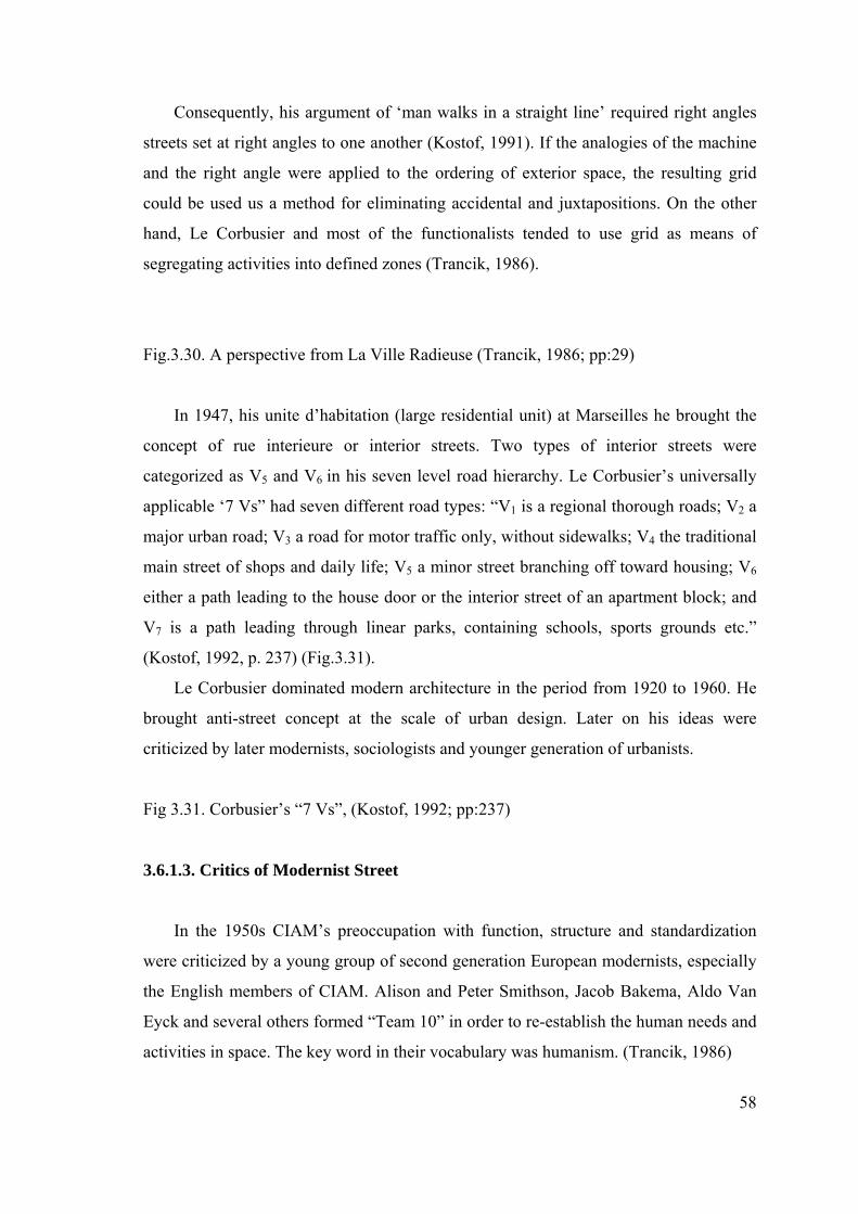
58
Consequently, his argument of ‘man walks in a straight line’ required right angles
streets set at right angles to one another (Kostof, 1991). If the analogies of the machine
and the right angle were applied to the ordering of exterior space, the resulting grid
could be used us a method for eliminating accidental and juxtapositions. On the other
hand, Le Corbusier and most of the functionalists tended to use grid as means of
segregating activities into defined zones (Trancik, 1986).
Fig.3.30. A perspective from La Ville Radieuse (Trancik, 1986; pp:29)
In 1947, his unite d’habitation (large residential unit) at Marseilles he brought the
concept of rue interieure or interior streets. Two types of interior streets were
categorized as V5 and V6 in his seven level road hierarchy. Le Corbusier’s universally
applicable ‘7 Vs” had seven different road types: “V1 is a regional thorough roads; V2 a
major urban road; V3 a road for motor traffic only, without sidewalks; V4 the traditional
main street of shops and daily life; V5 a minor street branching off toward housing; V6
either a path leading to the house door or the interior street of an apartment block; and
V7 is a path leading through linear parks, containing schools, sports grounds etc.”
(Kostof, 1992, p. 237) (Fig.3.31).
Le Corbusier dominated modern architecture in the period from 1920 to 1960. He
brought anti-street concept at the scale of urban design. Later on his ideas were
criticized by later modernists, sociologists and younger generation of urbanists.
Fig 3.31. Corbusier’s “7 Vs”, (Kostof, 1992; pp:237)
3.6.1.3. Critics of Modernist Street
In the 1950s CIAM’s preoccupation with function, structure and standardization
were criticized by a young group of second generation European modernists, especially
the English members of CIAM. Alison and Peter Smithson, Jacob Bakema, Aldo Van
Eyck and several others formed “Team 10” in order to re-establish the human needs and
activities in space. The key word in their vocabulary was humanism. (Trancik, 1986)
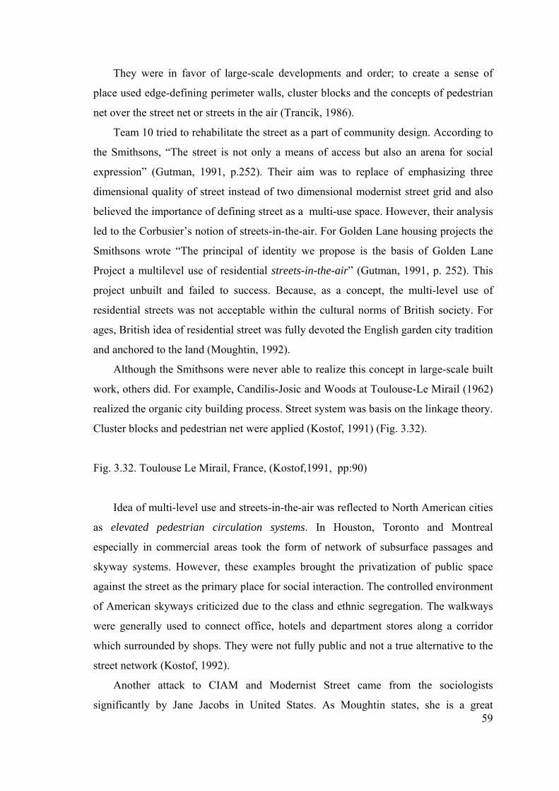
59
They were in favor of large-scale developments and order; to create a sense of
place used edge-defining perimeter walls, cluster blocks and the concepts of pedestrian
net over the street net or streets in the air (Trancik, 1986).
Team 10 tried to rehabilitate the street as a part of community design. According to
the Smithsons, “The street is not only a means of access but also an arena for social
expression” (Gutman, 1991, p.252). Their aim was to replace of emphasizing three
dimensional quality of street instead of two dimensional modernist street grid and also
believed the importance of defining street as a multi-use space. However, their analysis
led to the Corbusier’s notion of streets-in-the-air. For Golden Lane housing projects the
Smithsons wrote “The principal of identity we propose is the basis of Golden Lane
Project a multilevel use of residential streets-in-the-air” (Gutman, 1991, p. 252). This
project unbuilt and failed to success. Because, as a concept, the multi-level use of
residential streets was not acceptable within the cultural norms of British society. For
ages, British idea of residential street was fully devoted the English garden city tradition
and anchored to the land (Moughtin, 1992).
Although the Smithsons were never able to realize this concept in large-scale built
work, others did. For example, Candilis-Josic and Woods at Toulouse-Le Mirail (1962)
realized the organic city building process. Street system was basis on the linkage theory.
Cluster blocks and pedestrian net were applied (Kostof, 1991) (Fig. 3.32).
Fig. 3.32. Toulouse Le Mirail, France, (Kostof,1991, pp:90)
Idea of multi-level use and streets-in-the-air was reflected to North American cities
as elevated pedestrian circulation systems. In Houston, Toronto and Montreal
especially in commercial areas took the form of network of subsurface passages and
skyway systems. However, these examples brought the privatization of public space
against the street as the primary place for social interaction. The controlled environment
of American skyways criticized due to the class and ethnic segregation. The walkways
were generally used to connect office, hotels and department stores along a corridor
which surrounded by shops. They were not fully public and not a true alternative to the
street network (Kostof, 1992).
Another attack to CIAM and Modernist Street came from the sociologists
significantly by Jane Jacobs in United States. As Moughtin states, she is a great
60
apologist for the street. According to her, “streets and their sidewalks, the main public
places of a city, are its more vital organs. Think of a city and what comes to mind? Its
streets. If a city’s streets look dull, the city looks dull” (Moughtin, 1992, p.130). She
saw the dangers of modernist anti-street notion. The publicly unowned spaces between
blocks were the main generators of the crime. According to her, in order to create a safe
environment, “there must be eyes upon the street, eyes belonging to those we might call
the natural proprietors of the street... and the sidewalks must have users on it fairly
continuously, both to add to the number of effective eyes on the street and to induce
people in buildings along the street to watch the sidewalks in sufficient numbers”
(Moughtin, 1992, p. 130). Similar ideas can also be seen in Oskar Newman’s
‘Defensible space’.
After 1960’s New Rationalism headed by Aldo Rossi of Italy, Ricordo Bofill of
Spain, Leon and Rob Krier of Luxembourg. The Kriers’ main mission was to
reconstruct the traditional urban block as the definer of streets and squares. The formula
for Krier’s reconstruction of the European city was: “A city can only be reconstructed in
the forms of streets, squares, and quarters. The street and squares must present a
familiar pattern. Their dimensions and proportions must be these of the best and most
beautiful pre-industrial cities” (Ellin, 1996; p. 17).
According to R. Krier, modern movement is so limited in their scope and so lacking
in substance that they lost all credibility in a very short period of time. Early Modernists
were often considered the planning of urban paths in regional context and lost the
human scale in space. The Kriers defended the poetic content and aesthetic quality of
space. They also suggested that the real public open space elements; streets and square,
were omitted in the modernists’ regional context. The integrity, uniformity and
continuity aspects of the traditional streets were not taken into consideration.
The Kriers and their followers were fully recognized the importance of historic
street concept within the modern city. Rob Krier, in his work Urban Space, wrote: “The
asphalt carpet which serves as a channel for the movement of cars is still called a street.
It retains no connection with the original significance of the term. Certainly the
motorized transportation of people and goods is one of the primary functions of the
town, but requires no scenery in the space around it” (R.Krier, 1979; p. 22).
3.6.1.4. The Return to the Street
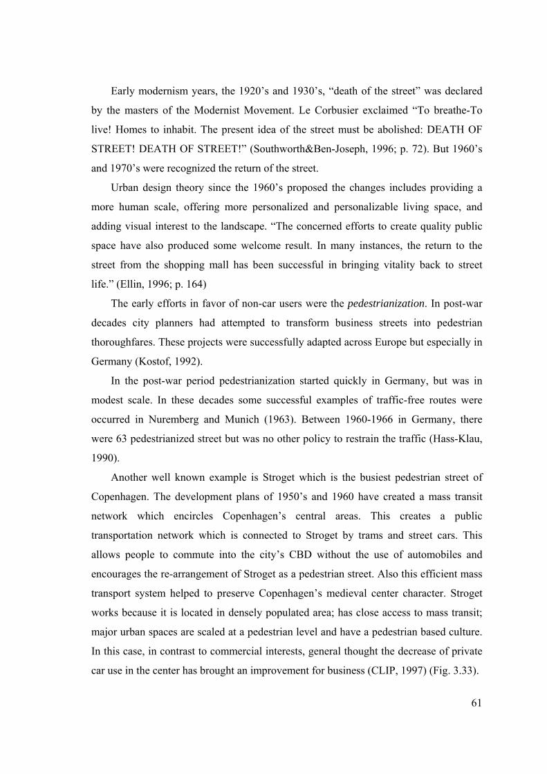
61
Early modernism years, the 1920’s and 1930’s, “death of the street” was declared
by the masters of the Modernist Movement. Le Corbusier exclaimed “To breathe-To
live! Homes to inhabit. The present idea of the street must be abolished: DEATH OF
STREET! DEATH OF STREET!” (Southworth&Ben-Joseph, 1996; p. 72). But 1960’s
and 1970’s were recognized the return of the street.
Urban design theory since the 1960’s proposed the changes includes providing a
more human scale, offering more personalized and personalizable living space, and
adding visual interest to the landscape. “The concerned efforts to create quality public
space have also produced some welcome result. In many instances, the return to the
street from the shopping mall has been successful in bringing vitality back to street
life.” (Ellin, 1996; p. 164)
The early efforts in favor of non-car users were the pedestrianization. In post-war
decades city planners had attempted to transform business streets into pedestrian
thoroughfares. These projects were successfully adapted across Europe but especially in
Germany (Kostof, 1992).
In the post-war period pedestrianization started quickly in Germany, but was in
modest scale. In these decades some successful examples of traffic-free routes were
occurred in Nuremberg and Munich (1963). Between 1960-1966 in Germany, there
were 63 pedestrianized street but was no other policy to restrain the traffic (Hass-Klau,
1990).
Another well known example is Stroget which is the busiest pedestrian street of
Copenhagen. The development plans of 1950’s and 1960 have created a mass transit
network which encircles Copenhagen’s central areas. This creates a public
transportation network which is connected to Stroget by trams and street cars. This
allows people to commute into the city’s CBD without the use of automobiles and
encourages the re-arrangement of Stroget as a pedestrian street. Also this efficient mass
transport system helped to preserve Copenhagen’s medieval center character. Stroget
works because it is located in densely populated area; has close access to mass transit;
major urban spaces are scaled at a pedestrian level and have a pedestrian based culture.
In this case, in contrast to commercial interests, general thought the decrease of private
car use in the center has brought an improvement for business (CLIP, 1997) (Fig. 3.33).
Fig. 3.33. Stroget, Copenhagen’s main pedestrianized street plan (a), street sections and
aerial- view of the site (b), (CLIP, 1997)
The new style of pedestrianization was launched in Germany with Munich Olympic
Games in 1972. This project supported the larger pedestrianized areas. In major German
cities large-scale pedestrianization was combined with an effective mass transit system
that was seen as crucial. Public transport would ensure accessibility into the heart of the
city. This concept was supported with large car parking facilities in close proximity of
the city center and improved roads (Hass-Klau, 1990). a
The most important development in favor of residents and pedestrians was
improvement of Dutch ‘Woonerf’ concept and area-wide traffic calming policies
gaining importance after 1980’s all over the world. The background of these approaches
will be examined in following chapters.
The United States experience was extremely different from European one. In USA,
because middle classes and working class people have moved to the suburbs their living
and use of public space has changed isolated travel in automobiles and the obsession
with traffic flow have diminished and degraded the life of the street. The impersonal
shopping center and commercial strip had replaced downtown as a setting for
communal life. Inner city streets occupied by lower income groups and became the
center of the crime and fear.1950’s was the decades of suburban shopping mall
movement. But in 1980’s pedestrianized new shopping streets were created in
downtown to revitalizing the city center. These shopping streets were combined with
recreational facilities includes entertainment, eating etc (Carr at al., 1992).
b
In 1980’s American Neo Traditionalism took the lead. New Urbanism has founded
in the middle of 1980’s by architects and planners in California and Florida. The New
Urbanism attempts to revive the features that make pre-World War II towns such a
treasure today. In Charter of the New Urbanism, new urbanists wrote:
• “A primary task of all urban architecture and landscape design is the physical
definition of streets and public spaces as places of shared use.
• The revitalization of urban places depends on safety and security. The design of
streets and buildings should reinforce safe environments but not at the expense
of accessibility and openness.
62
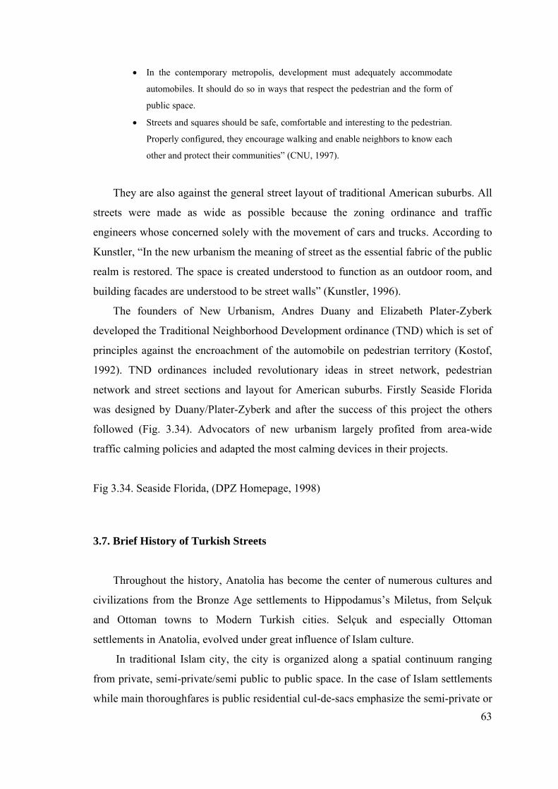
63
• In the contemporary metropolis, development must adequately accommodate
automobiles. It should do so in ways that respect the pedestrian and the form of
public space.
• Streets and squares should be safe, comfortable and interesting to the pedestrian.
Properly configured, they encourage walking and enable neighbors to know each
other and protect their communities” (CNU, 1997).
They are also against the general street layout of traditional American suburbs. All
streets were made as wide as possible because the zoning ordinance and traffic
engineers whose concerned solely with the movement of cars and trucks. According to
Kunstler, “In the new urbanism the meaning of street as the essential fabric of the public
realm is restored. The space is created understood to function as an outdoor room, and
building facades are understood to be street walls” (Kunstler, 1996).
The founders of New Urbanism, Andres Duany and Elizabeth Plater-Zyberk
developed the Traditional Neighborhood Development ordinance (TND) which is set of
principles against the encroachment of the automobile on pedestrian territory (Kostof,
1992). TND ordinances included revolutionary ideas in street network, pedestrian
network and street sections and layout for American suburbs. Firstly Seaside Florida
was designed by Duany/Plater-Zyberk and after the success of this project the others
followed (Fig. 3.34). Advocators of new urbanism largely profited from area-wide
traffic calming policies and adapted the most calming devices in their projects.
Fig 3.34. Seaside Florida, (DPZ Homepage, 1998)
3.7. Brief History of Turkish Streets
Throughout the history, Anatolia has become the center of numerous cultures and
civilizations from the Bronze Age settlements to Hippodamus’s Miletus, from Selçuk
and Ottoman towns to Modern Turkish cities. Selçuk and especially Ottoman
settlements in Anatolia, evolved under great influence of Islam culture.
In traditional Islam city, the city is organized along a spatial continuum ranging
from private, semi-private/semi public to public space. In the case of Islam settlements
while main thoroughfares is public residential cul-de-sacs emphasize the semi-private or
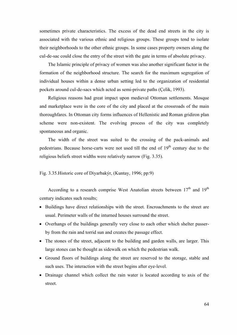
64
sometimes private characteristics. The excess of the dead end streets in the city is
associated with the various ethnic and religious groups. These groups tend to isolate
their neighborhoods to the other ethnic groups. In some cases property owners along the
cul-de-sac could close the entry of the street with the gate in terms of absolute privacy.
The Islamic principle of privacy of women was also another significant factor in the
formation of the neighborhood structure. The search for the maximum segregation of
individual houses within a dense urban setting led to the organization of residential
pockets around cul-de-sacs which acted as semi-private paths (Çelik, 1993).
Religious reasons had great impact upon medieval Ottoman settlements. Mosque
and marketplace were in the core of the city and placed at the crossroads of the main
thoroughfares. In Ottoman city forms influences of Hellenistic and Roman gridiron plan
scheme were non-existent. The evolving process of the city was completely
spontaneous and organic.
The width of the street was suited to the crossing of the pack-animals and
pedestrians. Because horse-carts were not used till the end of 19th century due to the
religious beliefs street widths were relatively narrow (Fig. 3.35).
Fig. 3.35.Historic core of Diyarbakýr, (Kuntay, 1996; pp:9)
According to a research comprise West Anatolian streets between 17th and 19th
century indicates such results;
• Buildings have direct relationships with the street. Encroachments to the street are
usual. Perimeter walls of the inturned houses surround the street.
• Overhangs of the buildings generally very close to each other which shelter passer-
by from the rain and torrid sun and creates the passage effect.
• The stones of the street, adjacent to the building and garden walls, are larger. This
large stones can be thought as sidewalk on which the pedestrian walk.
• Ground floors of buildings along the street are reserved to the storage, stable and
such uses. The interaction with the street begins after eye-level.
• Drainage channel which collect the rain water is located according to axis of the
street.
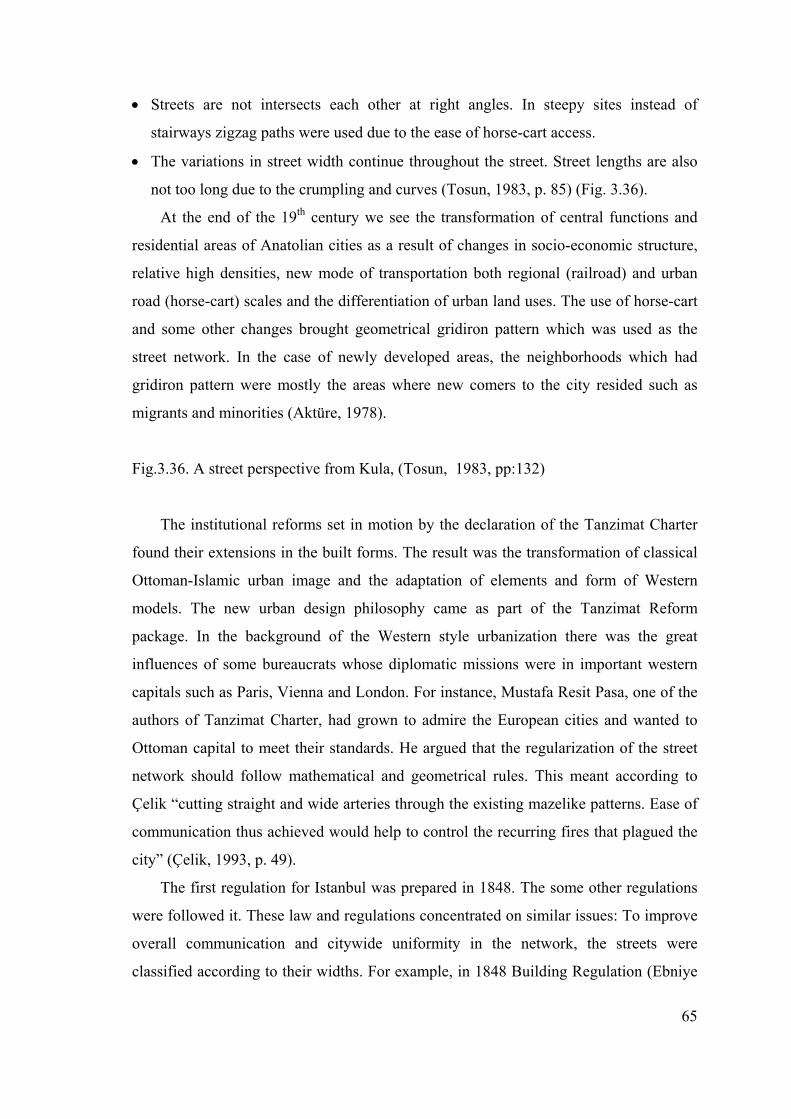
65
• Streets are not intersects each other at right angles. In steepy sites instead of
stairways zigzag paths were used due to the ease of horse-cart access.
• The variations in street width continue throughout the street. Street lengths are also
not too long due to the crumpling and curves (Tosun, 1983, p. 85) (Fig. 3.36).
At the end of the 19th century we see the transformation of central functions and
residential areas of Anatolian cities as a result of changes in socio-economic structure,
relative high densities, new mode of transportation both regional (railroad) and urban
road (horse-cart) scales and the differentiation of urban land uses. The use of horse-cart
and some other changes brought geometrical gridiron pattern which was used as the
street network. In the case of newly developed areas, the neighborhoods which had
gridiron pattern were mostly the areas where new comers to the city resided such as
migrants and minorities (Aktüre, 1978).
Fig.3.36. A street perspective from Kula, (Tosun, 1983, pp:132)
The institutional reforms set in motion by the declaration of the Tanzimat Charter
found their extensions in the built forms. The result was the transformation of classical
Ottoman-Islamic urban image and the adaptation of elements and form of Western
models. The new urban design philosophy came as part of the Tanzimat Reform
package. In the background of the Western style urbanization there was the great
influences of some bureaucrats whose diplomatic missions were in important western
capitals such as Paris, Vienna and London. For instance, Mustafa Resit Pasa, one of the
authors of Tanzimat Charter, had grown to admire the European cities and wanted to
Ottoman capital to meet their standards. He argued that the regularization of the street
network should follow mathematical and geometrical rules. This meant according to
Çelik “cutting straight and wide arteries through the existing mazelike patterns. Ease of
communication thus achieved would help to control the recurring fires that plagued the
city” (Çelik, 1993, p. 49).
The first regulation for Istanbul was prepared in 1848. The some other regulations
were followed it. These law and regulations concentrated on similar issues: To improve
overall communication and citywide uniformity in the network, the streets were
classified according to their widths. For example, in 1848 Building Regulation (Ebniye
66
Nizamnamesi) there were three categories of streets: Main avenues, 7.6 m wide;
ordinary avenues, 6 m wide; and other streets, 4.5 m wide. However, in 1882 Building
Law (Ebniye Kanunu) there were five-category street classification and the minimum
street width were increased from 4.5 m to 7.6 m (Çelik, 1993). This law was utopic
according to Tekeli because the widest street of Istanbul in this period was only 6 m
wide. In all regulations and laws between 1848 and 1882, the cul-de-sacs were
eliminated due to the transportation concerns and the danger of fires (Tekeli, 1996).
The Haussmannization of Europe had particular impact on redevelopment of
Ottoman capital especially in the form of wide uniform streets and post-fire schemes.
Although bourgeoisie moved into the spacious flats lining Haussmann boulevards in
Paris, in Istanbul no such displacement were made due to the remaining of the basic
qualities of old neighborhoods. With the opening up of the street network in the re-
planned neighborhoods and especially the eliminated of dead ends the street lost their
semi-private character and became thoroughfare. The building regulations of Istanbul
were extended to the other Anatolian cities towards the end of the 19th century (Çelik,
1993).
Ankara, center of the War of Independence, took the lead after the establishment of
new Turkish Republic in 1923. Western style urbanization had begun with the
redevelopment of Istanbul and continued with the making of new capital Ankara. The
new capital would be the model of the new social life in the direction of contemporary
western standards. This physical environment and social life would also reflect the
ideology of young Turkish Republic would be the model in the development of other
Turkish cities.
Between 1923 and 1927 there was a chaotic and unchecked urban growth in
Ankara. In order to regulate urban environment and to achieve the new Republic city
model an international competition was arranged. In the competition’s specifications
there were two important points in terms of streets:
• Existing streets and buildings before the competition would be preserved, if
necessary little corrections could be made.
• High-rise, prestigious buildings were recommended on the both side of the Ankara’s
two major streets: Cumhuriyet Street and Gazi Mustafa Kemal Boulevard (Tankut,
1993).
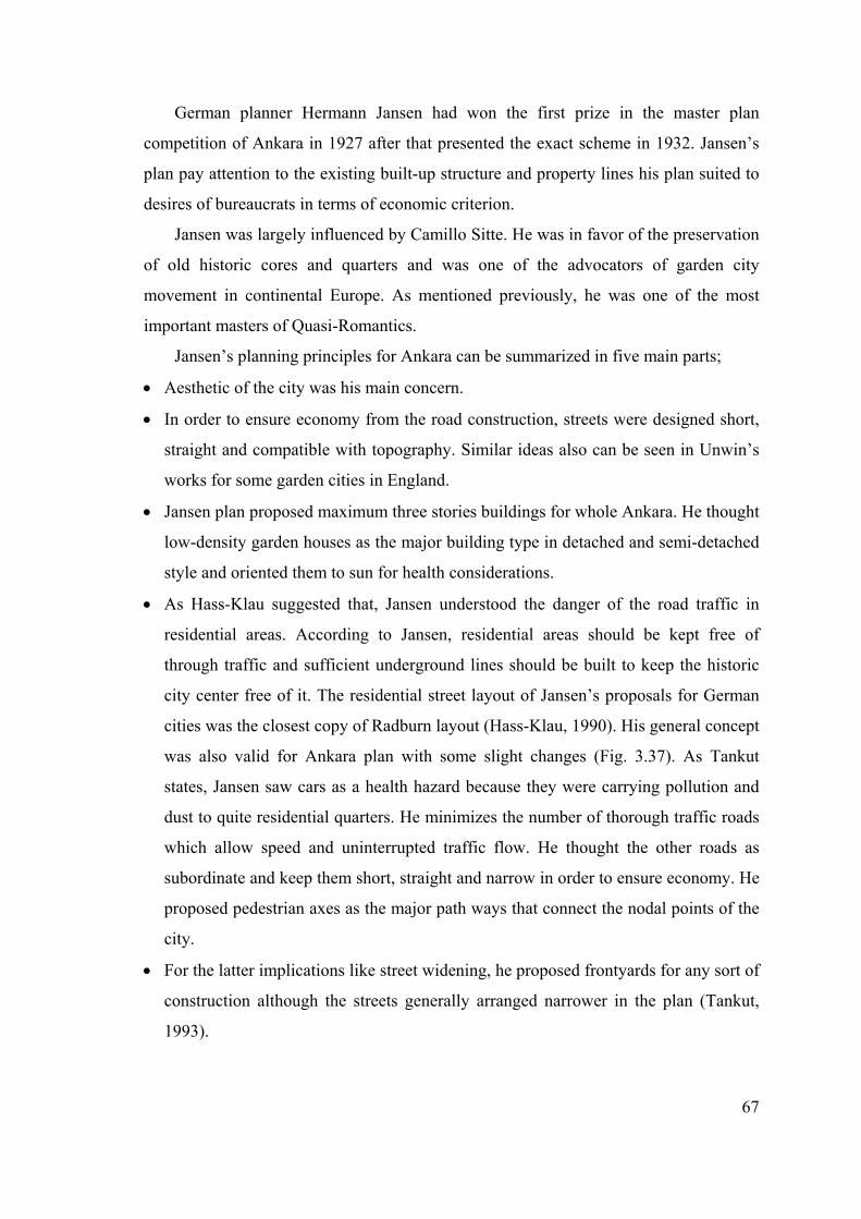
67
German planner Hermann Jansen had won the first prize in the master plan
competition of Ankara in 1927 after that presented the exact scheme in 1932. Jansen’s
plan pay attention to the existing built-up structure and property lines his plan suited to
desires of bureaucrats in terms of economic criterion.
Jansen was largely influenced by Camillo Sitte. He was in favor of the preservation
of old historic cores and quarters and was one of the advocators of garden city
movement in continental Europe. As mentioned previously, he was one of the most
important masters of Quasi-Romantics.
Jansen’s planning principles for Ankara can be summarized in five main parts;
• Aesthetic of the city was his main concern.
• In order to ensure economy from the road construction, streets were designed short,
straight and compatible with topography. Similar ideas also can be seen in Unwin’s
works for some garden cities in England.
• Jansen plan proposed maximum three stories buildings for whole Ankara. He thought
low-density garden houses as the major building type in detached and semi-detached
style and oriented them to sun for health considerations.
• As Hass-Klau suggested that, Jansen understood the danger of the road traffic in
residential areas. According to Jansen, residential areas should be kept free of
through traffic and sufficient underground lines should be built to keep the historic
city center free of it. The residential street layout of Jansen’s proposals for German
cities was the closest copy of Radburn layout (Hass-Klau, 1990). His general concept
was also valid for Ankara plan with some slight changes (Fig. 3.37). As Tankut
states, Jansen saw cars as a health hazard because they were carrying pollution and
dust to quite residential quarters. He minimizes the number of thorough traffic roads
which allow speed and uninterrupted traffic flow. He thought the other roads as
subordinate and keep them short, straight and narrow in order to ensure economy. He
proposed pedestrian axes as the major path ways that connect the nodal points of the
city.
• For the latter implications like street widening, he proposed frontyards for any sort of
construction although the streets generally arranged narrower in the plan (Tankut,
1993).
68
Fig.3.37. Jansen plan of the Workers’ Quarters (a), Plan of the Bahcelievler Quarter (b),
(METU Planning Archive, 1998)
Jansen had some problems in the adaptation of the plan. The first problem was the
dead end streets. Jansen’s cul-de-sacs were not accepted by the administrators due to
remaining of old traditional neighborhoods of Ottoman Empire. The other problem was
the lack of cadastre maps. This caused the changes in direction and routes of many
streets that proposed by Jansen.
As parallel to Jansen’s aesthetic concerns, the city council, who saw the uniformity
as an aesthetic factor, applied the uniform building heights and rooflines in major streets
and avenues (Tankut, 1993).
In 1933, a new building regulation (Yapi ve Yollar Kanunu) was prepared. This act
included the regulation of single buildings, and building lots and also the streets
classifications. According to the Act, dead end streets were prohibited and the
maximum width of the street was determined at least 9.50 m. 1933 Building Regulation
also contained some features of 1882 Ottoman Building Regulation (Ebniye Kanunu).
Despite its major deficiencies 1933 Building Regulation became the background of Law
6785 of 1956 (6785 sayili Imar Kanunu) (Tankut, 1993).
After 1935 Jansen’s plan was forced by speculators pressures, rapid rise in
population and its direct impact on land prices. In 1950’s Ankara had reached its final
population 30 years ahead of time. As a result of this process it was allowed to increase
in building heights an important street and avenues. Traffic congested in its streets. The
struggle of creating new Turkish Republic city model was interrupted by the economic
reasons and the danger of war.
In post war period we see the rapid urbanization in Turkish major cities. Turkey, as
Danielson & Keleş state, has been transformed by rapid urbanization. Urbanization in
Turkey is an inherent component of the process of modernization. (Danielson & Keleş,
1985) Rapid extension of cities brought some negative urban images: masses of
migrants, housing shortages, traffic jams, polluted air, fouled water etc. Migration has
been the prime factor in rapid urban growth. Large numbers of people moved to these
big cities but the existing social and physical infrastructure of the city could not absorb
the new comers. Booming in population and migration created squatter settlements that
surround the big cities. Also transportation preference of Turkey was dramatically
69
changed after 1950s: “Turkey’s highway construction program was designed to increase
the army’s mobility but roads can be used in both directions, and many villagers
seeking to better their lives used the improved highway system to move from rural areas
to the cities” (Danielson & Keleş, 1985 p. 17). This rapid transformation in Turkish
economic, social and political life influenced the urban streets directly. These
conditions can be discussed into three main parts:
1. Rapid Rise in Car-ownership:
Railroad policy, which continued till the World War II, was diminished and after
1950 highway policy became the government policy. In major Turkish cities rapid
urbanization has greatly demand for transportation at the same time spreading
development far beyond the reach of established services and facilities. With the high
rates of urban growth travel on streets and highways has expanded far more rapidly than
has the capacity of the transportation system.
After 1950s inadequate public transportation has attracted large numbers of private
operators (dolmuş) and private car-ownership. Explosive growth of this trend is a
reflection of economic prosperity an expanding middle class and Turkey’s substantial
investment in automobile production. More and more private cars crowded onto
outmoded road systems. These traffic problems were usual because the streets of such
cities were still remaining character of pre-industrial neighborhoods. Invasion of major
Turkish streets by automobile was recognized after the 1970s.
Door to door transport capability of trucks and buses caused radical changes in
transportation of freights and people. At the end of 1966 the first mass-product
automobile “Anadol” appeared and followed by Fiat, Renault and others. After this
period number of car-ownership changed the scale. For example, while only 3400
automobile exist in 1945, after mid 1970’s in second Five-Year Development Plan
(1968-1972) automobile production goal was announced as 57.000 auto-per year, today
it is extended to 800.000 auto-per year. Automobile mania was launched by narrow-
minded governmental policy in the form of industrialization and consumption. But the
mass production of automobile in Tekeli’s words has completely different results on
society and their social life habits apart from some other industrial products. Because
cities of Turkey has yet indicated the features of pre-industrial period and the functional
hierarchy of living and working areas could not provide the mobility of the society.
70
Since our street pattern were no longer carry the large amounts of automobile, city wide
urban renewals and upgrading of existing street network became inevitable (Tekeli,
1971).
Till the 1970s the inadequate organization of the transport modes in the city did not
allow the decentralization of urban functions. Therefore, the city grew as high density
compact form some changes were occurred in the urban scene:
• Demolition of historic parts of the city centers,
• Inadequacy of social facilities,
• Increase in density and the loss of green spaces,
• Decline of quality in public open spaces.
After mid 1970’s the first examples of pedestrianization of city center occurred in
Ankara in modest scale than spreaded to the other major cities. Streets and even
pedestrian sidewalks in the city center has become the storage for private cars. The
intolerable traffic chaos forced the major municipalities to consider on the high capacity
and more efficient transport alternatives (Subway & LRT) in this decade. One reason
for the high demand for light rail transportation (LRT) is that “it costs less than a full
metro, but has a higher image than bus system” (Gardner, 1995, p. 22).
The main failure of the transportation projects in developing countries the World
Bank found that is the institutional problems (Gardner, 1995). In Turkey, the central
government acts a dominant role in traffic control and transportation policy.
Above all, increasing numbers of traffic accidents became one of the unending
problems for big cities’ streets and highways. People are killed by cars in traffic while
walking or crossing more than they are killed by a stranger with a gun.
2. Modernization of Urban Public Space:
Modernization was the driving force of Turkish revolution. In urban scene we see
the boulevards as the most important symbol of modernization of Türkiye. Since 1920s
for almost all major cities and towns a boulevard, a ceremonial square and provincial
government unit have been constituted. According to Korat, this is the reflection of the
ideology on urban scene (Korat, 1997).
Open space, human scale and historic areas have all suffered from the unending
pressure of expansion in the major cities. In order to build new boulevards hundred of
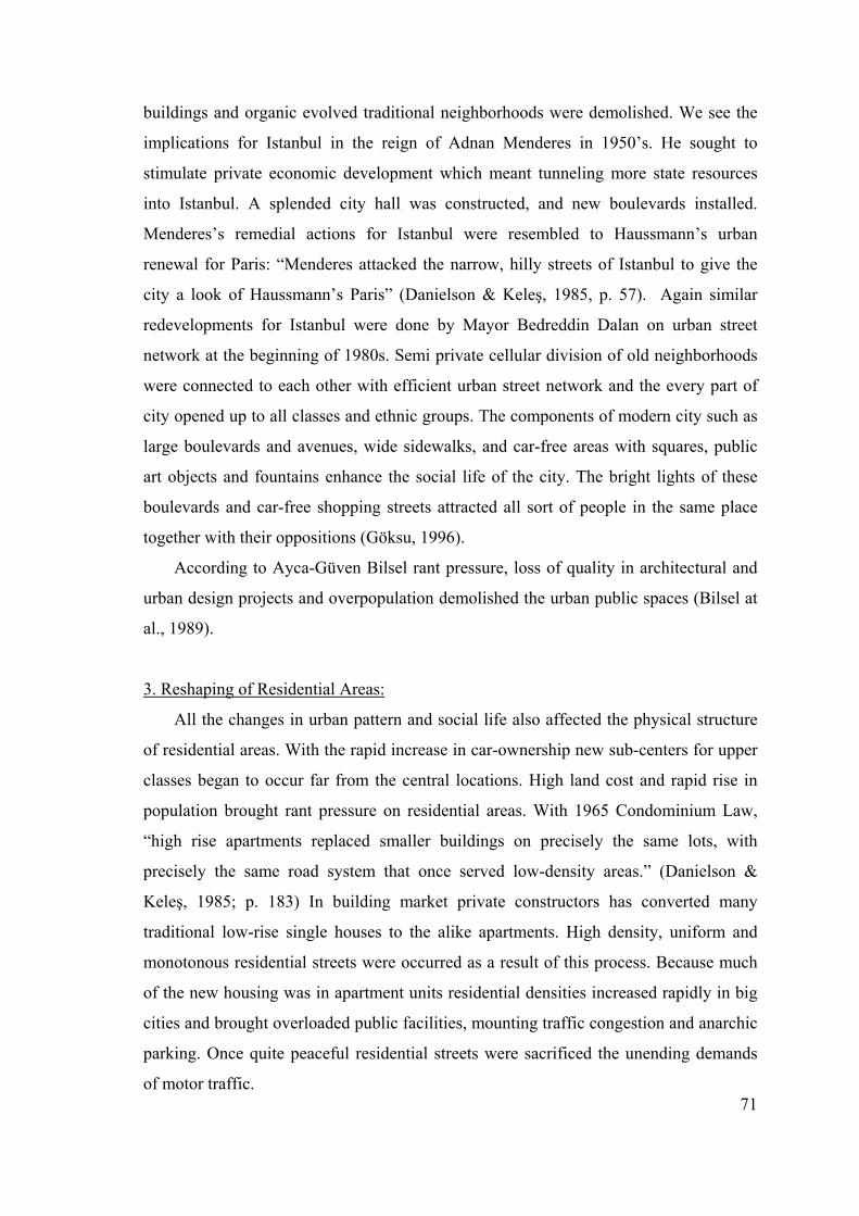
71
buildings and organic evolved traditional neighborhoods were demolished. We see the
implications for Istanbul in the reign of Adnan Menderes in 1950’s. He sought to
stimulate private economic development which meant tunneling more state resources
into Istanbul. A splended city hall was constructed, and new boulevards installed.
Menderes’s remedial actions for Istanbul were resembled to Haussmann’s urban
renewal for Paris: “Menderes attacked the narrow, hilly streets of Istanbul to give the
city a look of Haussmann’s Paris” (Danielson & Keleş, 1985, p. 57). Again similar
redevelopments for Istanbul were done by Mayor Bedreddin Dalan on urban street
network at the beginning of 1980s. Semi private cellular division of old neighborhoods
were connected to each other with efficient urban street network and the every part of
city opened up to all classes and ethnic groups. The components of modern city such as
large boulevards and avenues, wide sidewalks, and car-free areas with squares, public
art objects and fountains enhance the social life of the city. The bright lights of these
boulevards and car-free shopping streets attracted all sort of people in the same place
together with their oppositions (Göksu, 1996).
According to Ayca-Güven Bilsel rant pressure, loss of quality in architectural and
urban design projects and overpopulation demolished the urban public spaces (Bilsel at
al., 1989).
3. Reshaping of Residential Areas:
All the changes in urban pattern and social life also affected the physical structure
of residential areas. With the rapid increase in car-ownership new sub-centers for upper
classes began to occur far from the central locations. High land cost and rapid rise in
population brought rant pressure on residential areas. With 1965 Condominium Law,
“high rise apartments replaced smaller buildings on precisely the same lots, with
precisely the same road system that once served low-density areas.” (Danielson &
Keleş, 1985; p. 183) In building market private constructors has converted many
traditional low-rise single houses to the alike apartments. High density, uniform and
monotonous residential streets were occurred as a result of this process. Because much
of the new housing was in apartment units residential densities increased rapidly in big
cities and brought overloaded public facilities, mounting traffic congestion and anarchic
parking. Once quite peaceful residential streets were sacrificed the unending demands
of motor traffic.
72
But some good implementations have seen to preserve the historic sections of old
Turkish streets: Sogukçesme Street. Starting in 1976 the old buildings on the street were
taken in hand by the Automobile and Touring Club of Turkey, and their restoration
completed in 1986 (Fig. 3.38).
Fig.3.38. A view from Sogukcesme Street, Istanbul, (http://hcgl1.eng.ohio-state.edu)
The oldest houses in the street are typical of those built in Turkey prior to the
Ottoman modernization program of the 19th century. In the design of the street window
frames were renewed and gas lamps installed to light the street. Sogukçesme Street is a
traditional Ottoman street now, the flowers in marble pots all along the Hagia Sophia
fence giving off their fragrance. In opening Sogukçesme Street to public use, great care
has been taking to preserve its archeological and historical features, and its setting. The
street is off limits to motor vehicles of any kind, and perhaps this is the most welcome
news for the visitor who wishes to pause a while and savor Istanbul that was.
These factors that were mentioned above acted the transformative role on the
Turkish city streets. However, the impacts of automobile seem the most destructive one
among the others. Our major concern should improve the quality of urban streets and
make them livable, outdoor rooms of the city.
3.8. Conclusion
In early civilization’s cities, both regular and irregular forms of streets existed.
Narrow irregular ones which provide protection from enemies, sun and dust would be
imitated in Medieval for the same purposes.
In Hellenistic period, the concept of the street as an architectural entity was the
result of conscious aesthetic aims rather than of compelling functional grounds. In
Roman period the street layout was functional rather than aesthetic.
Special qualities of medieval were the small structures, small numbers and intimate
relations. Medieval towns and streets affected some 19th century urbanists such as
Camillo Sitte and advocates of car-free city concept today.
73
In Renaissance and Baroque periods, the concepts of discipline, order and geometry
shaped the urban streets. In contrast to pedestrian friendly medieval streets, baroque
street was in favor of the new absolute powers: bourgeoisie and autocracy.
Enlightenment was the age of disorder, chaos and revolutions. Baroque uniformity
was broken and town planning was mostly ignored due to the industrialization and
uncontrolled growth. Pre-appearance of modern street and section occurred after mid
18th century. But the advent of contemporary street would seem with the rise of
automobile in the early 1900’s.
In the past, the street was the place where social classes and social uses mixed.
However, the streets of motor age mostly served as the channels of motor traffic.
1960s and 1970s reflected the revival interest to return the street. Modernist anti-
street concept strongly criticized by wide variety reaction groups. The importance of
street in social life was recognized and attempted to restore again.
Turkish cities, as in many developing countries, were transformed by rapid
urbanization after 1950s. Invasion of the Turkish cities by automobiles was recognized
after mid 1970s. There is an immediate need to change the priorities in our streets in
favor of vulnerable road users.
In recent decades, traffic calming and pedestrian priority street design gained
importance in reviving the urban streets. Techniques and specific polices which
comprise pedestrian safety and priority will be discussed in following chapters.