Embed Size (px)
Citation preview

56
CHAPTER – 3
STUDY AREAS AND DATASETS
3.1 STUDY AREAS:
The present study analyses airborne and spaceborne SAR data viz., DLR-
ESAR, ENVISAT-ASAR and ALOS-PALSAR with specific objectives of
vegetation classification and above ground biomass estimation in different
ecoregions of India. Thus, several spatial, phenological and physiognomic
factors were considered to select suitable forested sites. They are as follows.
1. Dry deciduous forests of Rajpipla, Gujarat.
2. Mixed moist deciduous forests of Achanakmar-Amarkantak Biosphere
Reserve, Bilaspur, Chattisgarh.
3. Moist Deciduous/Semi evergreen forests of Dandeli, Karnataka
The geographical location of study sites, climate, geology, major vegetation
types, biomass ranges and datasets used are discussed as follows:
3.1.1 Rajpipla, Gujarat
The airborne DLR-ESAR data and spaceborne ENVISAT-ASAR, ALOS-
PALSAR datasets were acquired for forest area of Rajpipla, located in
Aravalli Mountains in Bharuch, Gujarat, India (fig 3.1).
57
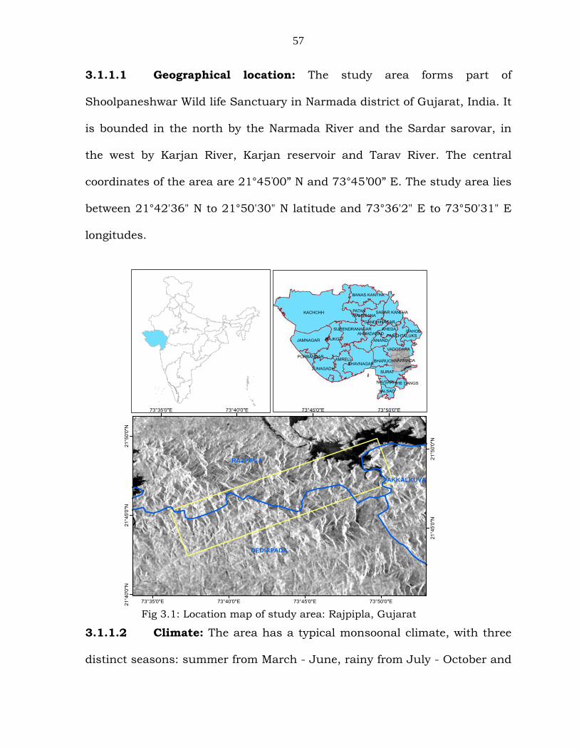
3.1.1.1 Geographical location: The study area forms part of
Shoolpaneshwar Wild life Sanctuary in Narmada district of Gujarat, India. It
is bounded in the north by the Narmada River and the Sardar sarovar, in
the west by Karjan River, Karjan reservoir and Tarav River. The central
coordinates of the area are 21°45’00” N and 73°45’00” E. The study area lies
between 21°42'36" N to 21°50'30" N latitude and 73°36'2" E to 73°50'31" E
longitudes.
3.1.1.2 Climate: The area has a typical monsoonal climate, with three
distinct seasons: summer from March - June, rainy from July - October and
Fig 3.1: Location map of study area: Rajpipla, Gujarat
KACHCHH
JAMNAGAR
SURAT
AMRELI
VADODARA
BHARUCH
ANANDRAJKOT
BHAVNAGAR
PATAN
JUNAGADH
DAHOD
BANAS KANTHA
AHMADABADSURENDRANAGAR KHEDA
SABAR KANTHAMAHESANA
VALSAD
NAVSARI
NARMADA
PANCHTALUKS
PORBANDAR
THE DANGS
GANDHINAGAR
RAJPIPLA
DEDIAPADA
AKKALKUVA
73°50'0"E
73°50'0"E
73°45'0"E
73°45'0"E
73°40'0"E
73°40'0"E
73°35'0"E
73°35'0"E
21°5
0'0"
N
21°5
0'0"
N
21°4
5'0"
N
21°4
5'0"
N
21°4
0'0"
N
58
winter from November-February. The temperature of the study area ranges
between a minimum of 10°C (average) in winter and to a maximum of 43°C
(average) in peak summer. Average rainfall of the area is about 1000 mm.
3.1.1.3 Terrain: Topography of the study area is highly varying with
gentle undulating plains to rugged hills. The area consists of moderately
hilly terrain comprising of height variation ranging from 607 ft to 1805 ft.
The hilly terrain with a continuum of small and high hillocks is a
characteristic feature of the area. The general slope of the area is towards
the west.
3.1.1.4 Forest types: The study area predominantly consists of Type
5A Tropical Dry Deciduous forest as classified by Champion and Seth
(1969).The predominant plant species in the study area is Teak with
patches of bamboo. Apart from bamboo, the study area is also dominated by
some other plant species viz., Haldu, Sadad, Amla, Khair, Harde, Amaltas,
mahuda, Tanach, Bor, Timru, Aritha, Karanj, bamboo etc. Dominant
species are Tectona grandis L. followed by Dendrocalamus strictus Nees.
Both species are homogenously distributed and occupy about 30% of the
study area. Tectona grandis, Bamboosa, Terminalia paniculata and
Cleistanthus, Butea monosperma are the dominant species in the study
area. Bushes have covered many areas, being relatively dense and up to 1 m
height or more. The biomass range and tree density are less in this area.
59
This study area is suitable for biomass analysis in C, L and P wavelength
bands. Studies on above ground biomass using different wavelength bands -
C, L and P, along with polarimetric analysis for vegetation characterization
was carried out in this study area.
3.1.2 Achanakmar - Amarkantak Biosphere Reserve, Bilaspur
The study area is located in Madhya Pradesh and Chhatisgarh states of
Central India. Spaceborne ENVISAT-ASAR and ALOS-PALSAR datasets were
acquired for this study area.
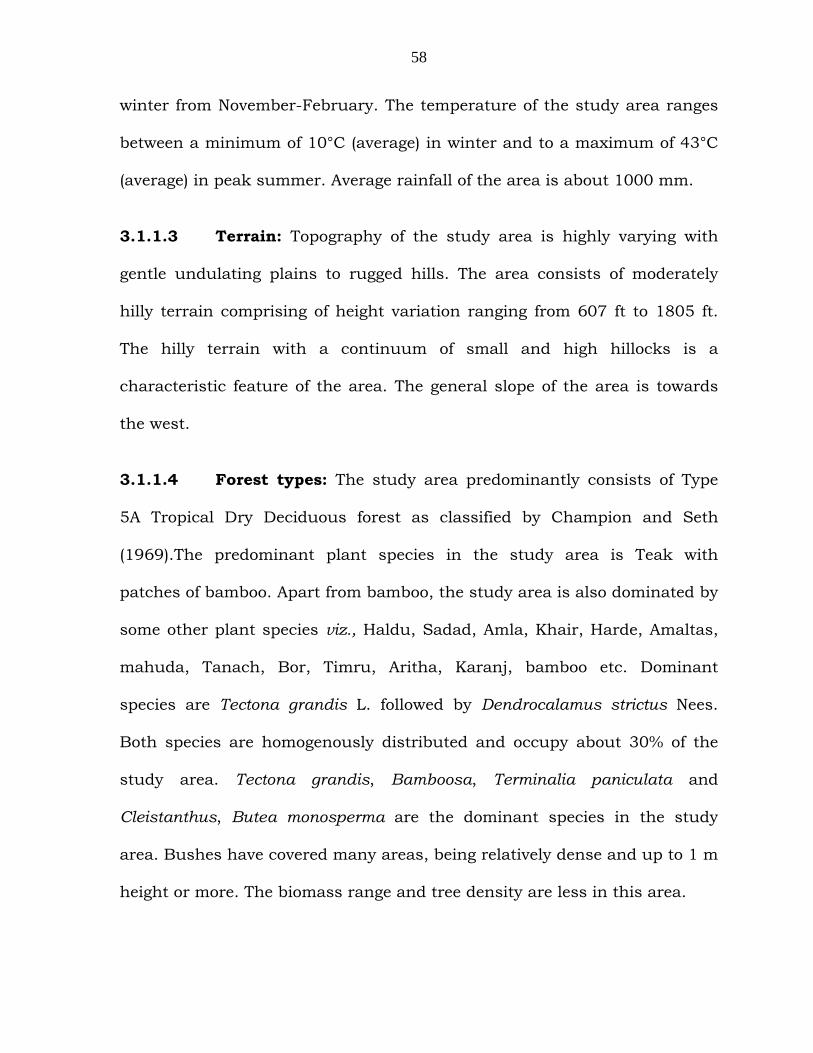
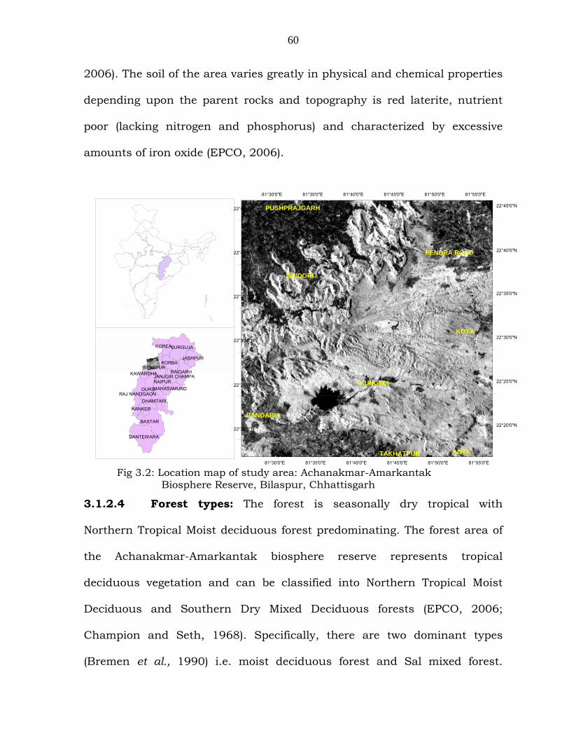
3.1.2.1 Geographical location: The Achanakmar-Amarkantak
biosphere reserve lies between 22°24' to 22°35' N latitude and 81°34' to
80°55' E longitude, having an area of 3835 sq. km, covering parts of
Madhya Pradesh and Chhattisgarh States (fig 3.2). The study area is a
biosphere reserve (notified by the Government of India on 30th March 2005),
with Achanakmar Wildlife Sanctuary as the core area.
3.1.2.2 Climate: The biosphere area has a typical monsoonal climate,
with three distinct seasons, summer from March - June, rainy from July -
October and winter from November-February (EPCO, 2006). The average
annual rainfall of the area is about 1624 mm. Mean daily temperature
ranges from 10.9° C (in January) to 39.1° C (may).
3.1.2.3 Geology: The soils of the area are generally lateritic, alluvial
and black cotton type, derived from granite, gneisses and basalts (EPCO,
60
2006). The soil of the area varies greatly in physical and chemical properties
depending upon the parent rocks and topography is red laterite, nutrient
poor (lacking nitrogen and phosphorus) and characterized by excessive
amounts of iron oxide (EPCO, 2006).
3.1.2.4 Forest types: The forest is seasonally dry tropical with
Northern Tropical Moist deciduous forest predominating. The forest area of
the Achanakmar-Amarkantak biosphere reserve represents tropical
deciduous vegetation and can be classified into Northern Tropical Moist
Deciduous and Southern Dry Mixed Deciduous forests (EPCO, 2006;
Champion and Seth, 1968). Specifically, there are two dominant types
(Bremen et al., 1990) i.e. moist deciduous forest and Sal mixed forest.
BASTAR
RAIPUR
SURGUJA
DURG
DANTEWARA
BILASPUR
KOREA KORBA
KANKER
RAIGARH JASHPUR
RAJ NANDGAON DHAMTARI
MAHASAMUND KAWARDHA JANJGIR CHAMPA
MUNGELI
DINDORI
KOTA
PENDRA ROAD
PANDARIA
PUSHPRAJGARH
KOTATAKHATPUR 81°55'0"E
81°55'0"E
81°50'0"E
81°50'0"E
81°45'0"E
81°45'0"E
81°40'0"E
81°40'0"E
81°35'0"E
81°35'0"E
81°30'0"E
81°30'0"E
22°45'0"N 22°45'0"N
22°40'0"N 22°40'0"N
22°35'0"N 22°35'0"N
22°30'0"N22°30'0"N
22°25'0"N22°25'0"N
22°20'0"N22°20'0"N
Fig 3.2: Location map of study area: Achanakmar-Amarkantak Biosphere Reserve, Bilaspur, Chhattisgarh
61
Terminalia Paniculata and Shorea Robusta are the dominant species in the
study area, interspersed with teak plantations.
Vegetation classification using texture measures and interferometric
coherence, above ground biomass estimation using C-band ENVISAT-ASAR
and ALOS-PALSAR data studies were carried out in this study site.
3.1.3 Dandeli, Karnataka
This study area is located in parts of Western Ghats of Karnataka, India.
Spaceborne ENVISAT-ASAR and ALOS-PALSAR datasets were acquired for
the study area and analysed for vegetation classification using multi-sensor
fusion technique.
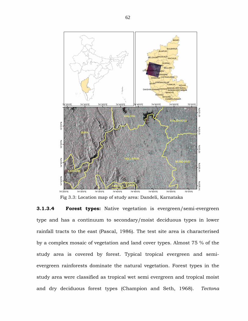
3.1.3.1 Geographic location: The study area covers parts of Haliyal
and Yellapur Forest divisions, Western Ghats of Karnataka, India (fig 3.3). It
is located from 14º40'15" to 15º21'30" N latitude and 74º16'34" to 75º21'34"
E longitude.
3.1.3.2 Geology: Geographically, it is a transitional zone between the
younger rocks of Deccan trap formation and the older crystalline rocks of
Archean shield of the Indian Peninsula. The soil on the exposed slopes and
broad valleys is loamy laterites with the pH values ranging from 5 to 5.8.
3.1.3.3 Climate: The area experiences southwest monsoon from mid
June to mid October. The mean annual rainfall is about 2500mm. The
mean monthly temperature ranges from 25 to 33ºC.
62
BIJAPUR
TUMKUR
RAICHUR
GULBARGA
BELGAUM
KOLAR
BELLARY
SHIMOGA
BIDAR
HASSAN
MYSORE
KOPPAL
UTTAR KANNADHAVERI
GADAG
UDUPI
BAGALKOT
MANDYA
CHITRADURGA
CHIKMAGALUR
DAVANGERE
KODAGU
DHARWAD
CHAMRAJNAGAR
BANGALORE RURALDAKSHIN KANNAD BANGALORE URBAN
SUPA
YELLAPURMUNDGOD
HALIYALKALGHATGI
KARWAR
SIRSIANKOLA
75°0'0"E
75°0'0"E
74°55'0"E
74°55'0"E
74°50'0"E
74°50'0"E
74°45'0"E
74°45'0"E
74°40'0"E
74°40'0"E
74°35'0"E
74°35'0"E
74°30'0"E
74°30'0"E
74°25'0"E
74°25'0"E
15°1
0'0"
N
15°5
'0"N
15°5
'0"N
15°0
'0"N
15°0
'0"N
14°5
5'0"
N
14°5
5'0"
N
14°5
0'0"
N
14°5
0'0"
N
3.1.3.4 Forest types: Native vegetation is evergreen/semi-evergreen
type and has a continuum to secondary/moist deciduous types in lower
rainfall tracts to the east (Pascal, 1986). The test site area is characterised
by a complex mosaic of vegetation and land cover types. Almost 75 % of the
study area is covered by forest. Typical tropical evergreen and semi-
evergreen rainforests dominate the natural vegetation. Forest types in the
study area were classified as tropical wet semi evergreen and tropical moist
and dry deciduous forest types (Champion and Seth, 1968). Tectona
Fig 3.3: Location map of study area: Dandeli, Karnataka
63
grandis, Xylia xylocarpa, Lagerstroemia lanceolata, Terminalia alata,
Terminalia paniculata, Dillenia pentagyna are the dominant tree species and
under-story is represented by Psychotria dalzelli, Eupatorium odoratum,
Wagatea spicata and Ziziphus spp.
Field inventory and Phytosociological data analysis of the ground truth
collected in the study areas are discussed in Chapter-7 of above ground
biomass estimation.
3.2 DATA SETS USED IN THE PRESENT STUDY:
Airborne DLR-ESAR data was acquired for Rajpipla study site; ENVISAT-
ASAR and ALOS-PALSAR data was acquired for all the three study areas
namely Rajpipla, Bilaspur and Dandeli. Additionally, IRS P6 LISS-III and
LISS-IV data acquired for all the three study areas were used as reference
datasets, table 3.1.
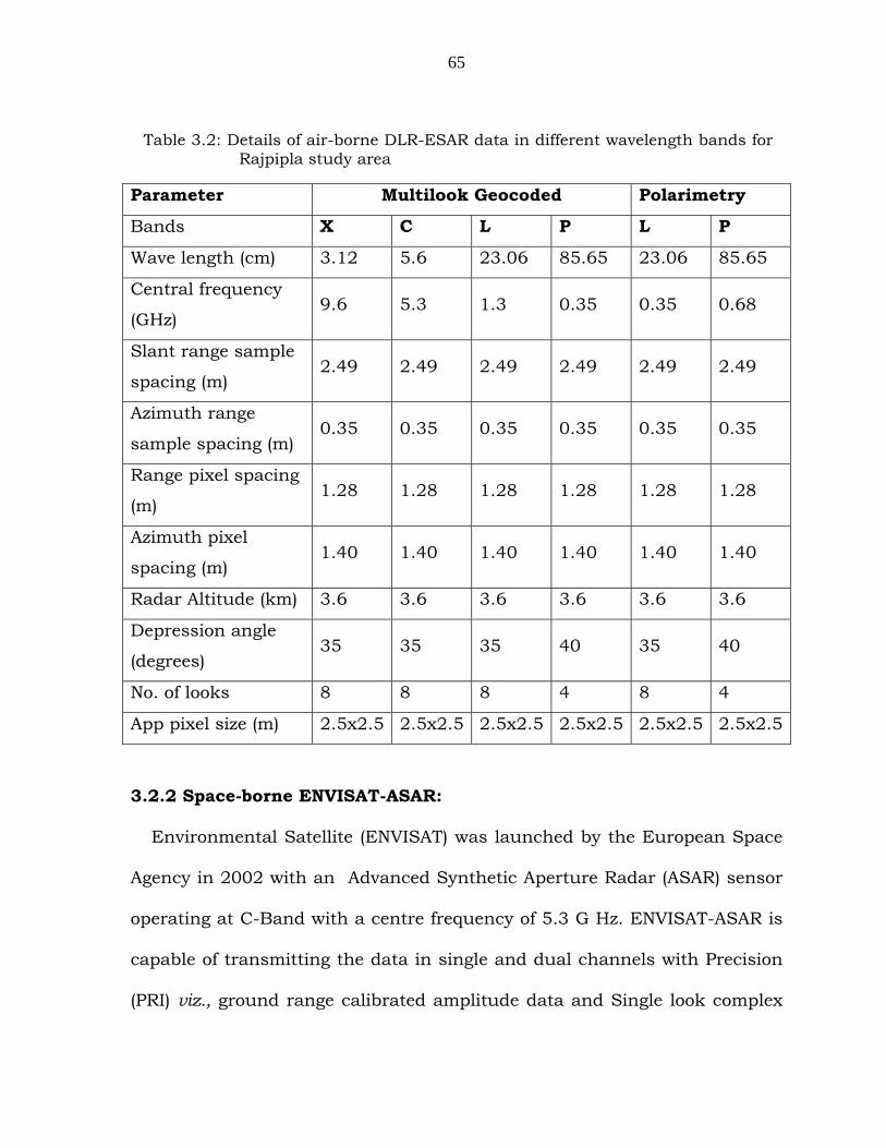
3.2.1 Airborne DLR-ESAR data
The DLR-ESAR is a multi-frequency and multi-polarimetric airborne
Experimental Synthetic Aperture Radar with 4.5m spatial resolution and a
pixel size of 1.2 m. The data were collected in X, C, L and P-bands. The X
band data was acquired in two polarizations HH and VV. The DLR-ESAR
data was acquired on 2nd October 2004 for Rajpipla study area. Multi-look
geocoded data of C, L and P-bands in HH, HV, VV and VH polarizations
were generated from Single Look Complex (SLC) data (table 3.2).
64
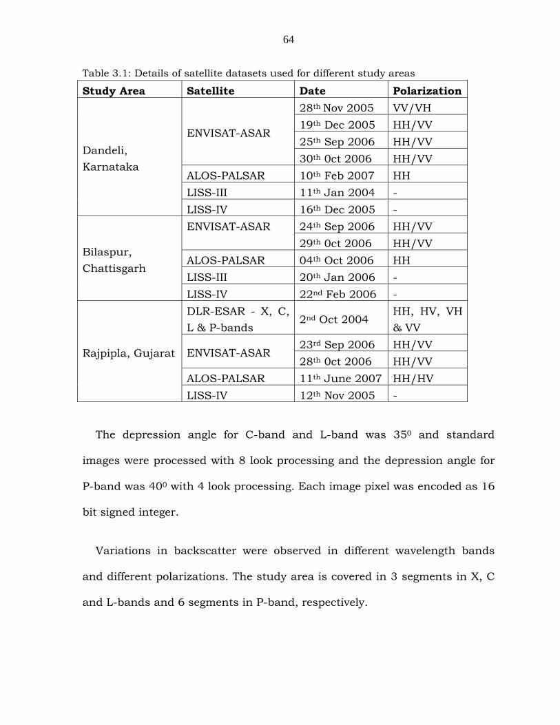
Table 3.1: Details of satellite datasets used for different study areas
Study Area Satellite Date Polarization 28th Nov 2005 VV/VH 19th Dec 2005 HH/VV 25th Sep 2006 HH/VV
ENVISAT-ASAR
30th 0ct 2006 HH/VV ALOS-PALSAR 10th Feb 2007 HH LISS-III 11th Jan 2004 -
Dandeli, Karnataka
LISS-IV 16th Dec 2005 - 24th Sep 2006 HH/VV ENVISAT-ASAR
29th 0ct 2006 HH/VV ALOS-PALSAR 04th Oct 2006 HH LISS-III 20th Jan 2006 -
Bilaspur, Chattisgarh
LISS-IV 22nd Feb 2006 - DLR-ESAR - X, C, L & P-bands
2nd Oct 2004 HH, HV, VH & VV
23rd Sep 2006 HH/VV ENVISAT-ASAR
28th 0ct 2006 HH/VV ALOS-PALSAR 11th June 2007 HH/HV
Rajpipla, Gujarat
LISS-IV 12th Nov 2005 -
The depression angle for C-band and L-band was 350 and standard
images were processed with 8 look processing and the depression angle for
P-band was 400 with 4 look processing. Each image pixel was encoded as 16
bit signed integer.
Variations in backscatter were observed in different wavelength bands
and different polarizations. The study area is covered in 3 segments in X, C
and L-bands and 6 segments in P-band, respectively.
65
3.2.2 Space-borne ENVISAT-ASAR:
Environmental Satellite (ENVISAT) was launched by the European Space
Agency in 2002 with an Advanced Synthetic Aperture Radar (ASAR) sensor
operating at C-Band with a centre frequency of 5.3 G Hz. ENVISAT-ASAR is
capable of transmitting the data in single and dual channels with Precision
(PRI) viz., ground range calibrated amplitude data and Single look complex
Parameter Multilook Geocoded Polarimetry
Bands X C L P L P
Wave length (cm) 3.12 5.6 23.06 85.65 23.06 85.65
Central frequency
(GHz) 9.6 5.3 1.3 0.35 0.35 0.68
Slant range sample
spacing (m) 2.49 2.49 2.49 2.49 2.49 2.49
Azimuth range
sample spacing (m) 0.35 0.35 0.35 0.35 0.35 0.35
Range pixel spacing
(m) 1.28 1.28 1.28 1.28 1.28 1.28
Azimuth pixel
spacing (m) 1.40 1.40 1.40 1.40 1.40 1.40
Radar Altitude (km) 3.6 3.6 3.6 3.6 3.6 3.6
Depression angle
(degrees) 35 35 35 40 35 40
No. of looks 8 8 8 4 8 4
App pixel size (m) 2.5x2.5 2.5x2.5 2.5x2.5 2.5x2.5 2.5x2.5 2.5x2.5
Table 3.2: Details of air-borne DLR-ESAR data in different wavelength bands for Rajpipla study area
66
(SLC) acquisition modes. In dual mode, the sensor could be operated in
different alternating polarization modes viz., HH+HV, VV+VH and HH+VV.
The data can be acquired in any of the selected beam positions (IS2–IS7)
depending on the incidence angle ranges, in image mode, alternate
polarization mode and wide swath mode. The data acquired for present
study was alternate polarization mode. The resolutions, incidence angle
ranges in different modes are given in specifications below.
This is the first satellite which increased capability in terms of coverage,
range of incidence angles, polarization, and modes of operation.
3.2.2.1 ENVISAT-ASAR Specifications
Agency European Space Agency
Frequency C-band
Polarization HH or VV or HH/HV or VV/VH
Ground Resolution 15 to 1000 m
Acquisition Modes Strip map (Image), Alternating Polarization
mode, ScanSAR (Wide Swath, Globe)
Swath 100 to 405 km
Repeat cycle 35 days
Launch 2001.
3.2.2.2 Acquired ASAR datasets: The acquired datasets for Rajpipla
and Dandeli study area were in alternating polarization IS2 mode viz.,
67
(HH/VV, incidence angle ranges from 19.20 to 26.70) with a swath of 105km
in descending node. For Bilaspur study area, the acquired datasets are in
alternating polarization IS3 mode viz., (HH/VV, incidence angle ranges from
26.00 to 31.40) with a swath of 105km in descending node.
Amplitude (Precision image format) data and repeat pass single look
complex (SLC) data for interferometry were acquired for the three study
areas for vegetation classification and above ground biomass estimation.
3.2.3 Space borne ALOS-PALSAR:
Advanced Land Observing Satellite (ALOS) was launched on 24 Jan 2006
by JAXA (Japan Aerospace Exploration Agency) with an L-band sensor
named Phased Array L-band Synthetic Aperture Radar (PALSAR).
The Phased Array L-band Synthetic Aperture Radar (PALSAR) is an active
microwave sensor operating in L-band frequency. The centre frequency of
the PALSAR is 1.24 GHz. L-band PALSAR data is useful in acquiring
vegetation information, distinguishing features on the ground, classification
of land use, etc.
PALSAR works in following 3 observation modes: Fine mode, ScanSAR
mode and Polarimetric mode.
68
3.2.3.1 ALOS-PALSAR Specifications
Agency Japan Aerospace Exploration Agency
Frequency L-band
Polarization Single Pol, Dual Pol, Full Pol
Acquisition Modes Stripmap (Fine) and ScanSAR
Ground Resolution 7 to 100 m
Swath 20 to 350 km
Repeat Cycle 44 days
Launch 2006
As the polarimetric data is not available over Indian regions, fine mode
data of PALSAR is selected for the study sites for the above ground biomass
estimation.
3.2.3.2 Acquired PALSAR datasets: The acquired datasets of ALOS-
PALSAR for Dandeli and Bilaspur study areas were in fine mode, single
polarization (HH) data with off nadir angle of 34.30 and 41.50 respectively.
Dual polarized HH/HV fine mode data with off nadir angle 34.30 was
acquired for Rajpipla study site.
Corresponding optical data viz., LISS-III, LISS-IV, CARTOSAT-1 for
Rajpipla were also acquired for ground truth collection and comparative
analysis with SAR data. The ESAR, ASAR and PALSAR datasets acquired
were converted to ground range, calibrated and preprocessed to derive the
specific objectives as explained in next chapters.


![The 4th ACS/IEEE International Conference on Computer ...sharif.edu/~ghodsi/papers/PHITS.pdf · In our study, we used the datasets that are publicly available at [19]. These datasets](https://img.pdfslide.us/doc/110x75/5f899c7cc76e4a303d301722/the-4th-acsieee-international-conference-on-computer-ghodsipapersphitspdf.jpg)