Embed Size (px)
Citation preview
Mitigation and Monitoring Proposal Willits Bypass Project
January 2012 3-1
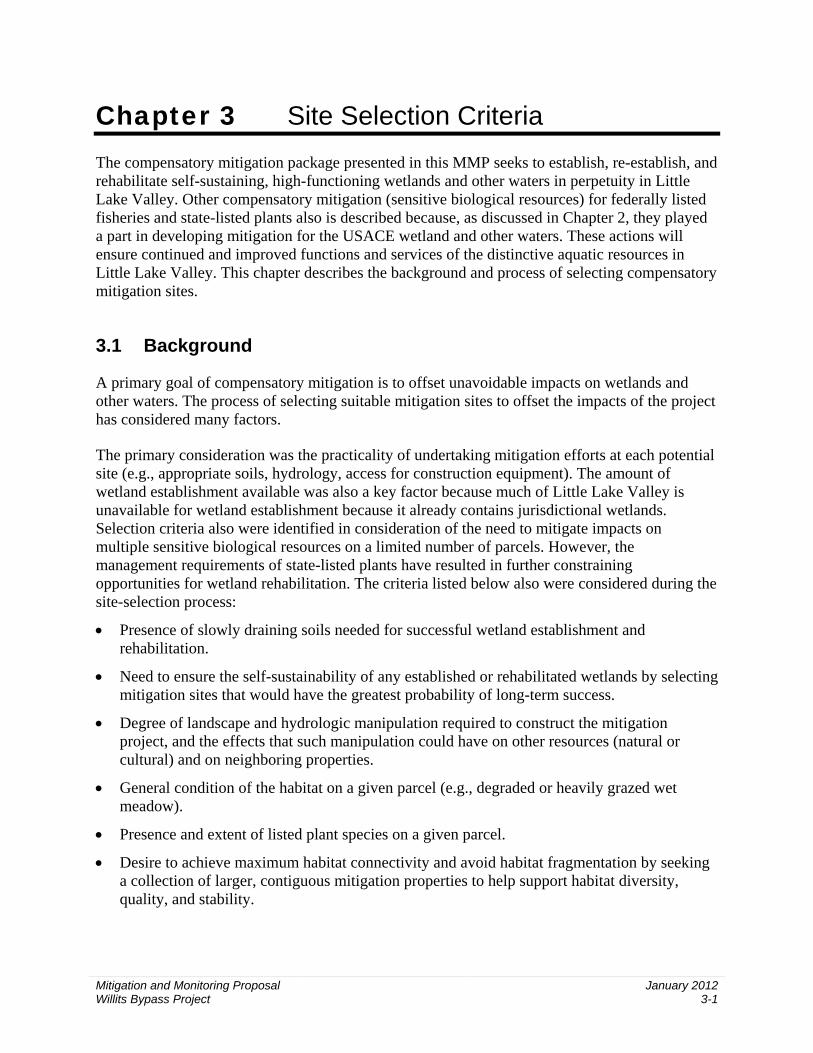
Chapter 3 Site Selection Criteria The compensatory mitigation package presented in this MMP seeks to establish, re-establish, and rehabilitate self-sustaining, high-functioning wetlands and other waters in perpetuity in Little Lake Valley. Other compensatory mitigation (sensitive biological resources) for federally listed fisheries and state-listed plants also is described because, as discussed in Chapter 2, they played a part in developing mitigation for the USACE wetland and other waters. These actions will ensure continued and improved functions and services of the distinctive aquatic resources in Little Lake Valley. This chapter describes the background and process of selecting compensatory mitigation sites.
3.1 Background
A primary goal of compensatory mitigation is to offset unavoidable impacts on wetlands and other waters. The process of selecting suitable mitigation sites to offset the impacts of the project has considered many factors.
The primary consideration was the practicality of undertaking mitigation efforts at each potential site (e.g., appropriate soils, hydrology, access for construction equipment). The amount of wetland establishment available was also a key factor because much of Little Lake Valley is unavailable for wetland establishment because it already contains jurisdictional wetlands. Selection criteria also were identified in consideration of the need to mitigate impacts on multiple sensitive biological resources on a limited number of parcels. However, the management requirements of state-listed plants have resulted in further constraining opportunities for wetland rehabilitation. The criteria listed below also were considered during the site-selection process:
• Presence of slowly draining soils needed for successful wetland establishment and rehabilitation.
• Need to ensure the self-sustainability of any established or rehabilitated wetlands by selecting mitigation sites that would have the greatest probability of long-term success.
• Degree of landscape and hydrologic manipulation required to construct the mitigation project, and the effects that such manipulation could have on other resources (natural or cultural) and on neighboring properties.
• General condition of the habitat on a given parcel (e.g., degraded or heavily grazed wet meadow).
• Presence and extent of listed plant species on a given parcel.
• Desire to achieve maximum habitat connectivity and avoid habitat fragmentation by seeking a collection of larger, contiguous mitigation properties to help support habitat diversity, quality, and stability.

Chapter 3. Site Selection Criteria
Mitigation and Monitoring Proposal Willits Bypass Project
January 2012 3-2
Before evaluating potential offsite mitigation parcels on the basis of these criteria, two key limiting factors needed to be addressed: (1) the physical presence of suitable soils and hydrology needed for successful wetland establishment and rehabilitation, and (2) the willingness of landowners to sell their parcels. These two limiting factors are interconnected, as discussed below.
The rationale behind selection of the current offsite mitigation properties for each jurisdictional resource type addressed in this MMP is described in Sections 3.2 and 3.3. The locations of the offsite mitigation properties are shown in Figures 2-1a and 2-1b. The rationale behind selection of offsite mitigation properties for state-listed plants is summarized in Section 3.5. A summary of the rationale behind selection of offsite mitigation properties for other sensitive biological resources will be covered in detail under a separate MMP. The discussion relative to other sensitive biological resources is included to provide the overall context of mitigation actions at the offsite mitigation properties.
The rationale behind selection of the onsite other waters locations is discussed in Section 3.3.
3.2 Mitigation Site Selection for Jurisdictional Wetland Establishment
Identification or availability of suitable upland area for wetland establishment presented the most challenging obstacle; identification and availability of suitable opportunities to mitigate impacts on other resource types was less challenging. Because of state and federal policies of no net loss of wetlands, it was necessary to seek upland habitat types that could support wetland establishment. Much of Little Lake Valley historically has supported wetland habitats, a large amount of which has been degraded through historical land use practices, including grazing and agricultural management.
Wetland rehabilitation will be used to compensate for the deficiency of suitable lands for wetland establishment. Wetland rehabilitation actions will result in the development of successional plant communities to replace nonnative, invasive managed pasture and haylands in wetlands. Wetland rehabilitation by definition does not contribute to the establishment of new wetlands. In addition, while degraded wetlands may be rehabilitated, on a per-acre basis, they provide only low compensatory mitigation credit and low functions and services lift above current conditions.
Efforts to identify suitable wetland establishment and rehabilitation properties in the Little Lake Valley began with preparation of the project’s wetland mitigation feasibility study (2005 Feasibility Study; California Department of Transportation 2005b). The 2005 Feasibility Study was a preliminary investigation of candidate mitigation sites intended to determine whether onsite conditions existed that would support the establishment of wetlands.
Caltrans then identified all parcels owned by willing sellers in the valley. A large-scale reconnaissance-level field investigation of the available parcels was conducted to identify parcels with the greatest potential for wetland establishment. Twenty-six parcels totaling approximately 250 acres of potential establishment were identified as likely candidates for mitigation because they appeared to have slow-draining soils, would not require extensive grading, were contiguous

Chapter 3. Site Selection Criteria
Mitigation and Monitoring Proposal Willits Bypass Project
January 2012 3-3
with other candidate properties, were available for sale or easement, and had at least some uplands that potentially could be converted to wetlands.
Therefore, the 2005 Feasibility Study concluded that favorable conditions were present on the 26 candidate parcels and that sufficient wetland establishment opportunities appeared to be available within Little Lake Valley. Because the cost to study all candidate parcels in detail would have been prohibitive, the 2005 Feasibility Study was conducted at a coarse scale; no formal wetland delineations were conducted at that time. Caltrans held a number of meetings with the resource agencies during development of the 2005 Feasibility Study and provided draft copies for their review and comment. Although no formal written concurrence with the 2005 Feasibility Study was required under the 1994 National Environmental Policy Act/Clean Water Act Section 404 Integration Process Memorandum of Understanding (NEPA/404 MOU), Caltrans received informal verbal concurrence on the adequacy of its findings from the agencies.
Following completion of the 2005 Feasibility Study, a conceptual mitigation plan (CMP) (California Department of Transportation 2006a) was developed in accordance with the NEPA/404 MOU. The final CMP presented a conceptual plan of the overall proposed mitigation strategy for the project, as well as preliminary impact numbers and projected mitigation ratios for each resource based on the best design information available at that time. As with the development the 2005 Feasibility Study, the resource agencies played a collaborative role in the development of the CMP by participating in meetings and reviewing and commenting on draft versions of the document. In accordance with NEPA/404 MOU Appendix A, formal written concurrence was received from USACE, EPA, NMFS, and the U.S. Fish and Wildlife Service (USFWS) that the CMP established an appropriate framework to mitigate project impacts on waters of the United States, including wetlands. The CMP also presented mitigation strategies for other sensitive resources.
Following completion of the CMP and the FEIS/FEIR (California Department of Transportation 2006b), Caltrans initiated a series of more detailed field studies on the candidate mitigation properties; the results were documented in the mitigation parcels report (MPR) (California Department of Transportation 2007). The MPR narrowed the search for suitable candidate mitigation properties to 15 parcels, with most of the wetland establishment efforts planned on the Gary and Diane Ford parcels and a large amount of wetland and Baker’s meadowfoam preservation planned on the Rutledge parcels. Formal wetland delineations then were initiated on this short list of parcels to confirm their establishment potential.
After completion of the MPR and during the wetland delineation fieldwork, the Fords and the Rutledges informed Caltrans that they no longer were interested in offering any of their land for mitigation. In addition, during a February 2008 field review involving Caltrans, staff from multiple natural resource agencies, and wetland restoration experts, it was determined that the Benbow parcels and some of the Ford parcels had limited potential for wetland establishment because most of the properties were already wetlands. This determination further reduced the list of prospective candidate parcels for wetland establishment.
The remaining parcels on the list were concluded to have very limited opportunities for wetland establishment and had been included in the MPR primarily as mitigation for other resources. In March 2008, Caltrans and the resource agencies determined that further efforts should be made

Chapter 3. Site Selection Criteria
Mitigation and Monitoring Proposal Willits Bypass Project
January 2012 3-4
to identify additional willing sellers in Little Lake Valley to ensure that no wetland establishment opportunities had been overlooked. Therefore, Caltrans reinitiated contact with parcel owners initially contacted in 2004 during the 2005 Feasibility Study effort and with additional parcel owners who had not responded previously. As a result of this effort, 11 additional candidate parcels (six parcel owners) were identified for further reconnaissance-level review: Frost, MGC Plasma, Goss, Arkelian, DeFranco, and Carrillo.
Of these parcels, Frost East and West appeared to have the most readily available water sources and to be the most promising for wetland establishment and rehabilitation. At the time, initial wetland delineations conducted on the Frost parcels identified a substantial amount of upland—more than 100 acres—that could provide opportunities for wetland establishment. Later, during the wetland verification process, USACE delineated these areas as wetlands; consequently, they were no longer suitable for wetland establishment. The Frost parcels were desirable because of their continuity with one of the 11 contiguous Ford and Wildlands parcels. Combined, the Frost, Nance, Ford, Wildlands, and Benbow parcels would make up a large contiguous mitigation area (more than 1,100 acres) at the north end of the valley.
The remaining parcels analyzed in 2008—Carrillo, DeFranco, Arkelian, Goss, MGC Plasma North, and MGC Plasma Middle—appeared to present limited establishment and rehabilitation opportunities as a result of difficult-to-access water sources; consequently, wetland establishment would require extensive manipulation of hydrology (e.g., ditches, culverts, water pumping). In some instances (DeFranco and Carrillo), established wetlands potentially could affect the groundwater level on neighboring properties. The establishment of a raised water table could limit neighbors’ crop production and grazing. These issues called into question the proposed wetlands’ long-term ability to support successful, naturally functioning wetland systems. In addition, many of these parcels are small and lack overall connectivity. In light of these potential complications, the DeFranco and Carrillo parcels were ruled out as candidates for wetland establishment.
A letter sent to the resource agencies in July 2008 indicated that establishment opportunities continued to be elusive. Establishment opportunities on the Frost parcels were unlikely to result in as much acreage as originally estimated, and adequate opportunities on the remaining properties were doubtful. The letter indicated that Caltrans intended to focus on a mixed strategy of wetland establishment, rehabilitation, and preservation. RWB responded with a letter in September 2008 reaffirming the state’s no-net-loss policy. On October 20, 2008, a meeting was held between Caltrans and RWB to determine a mutually agreeable strategy for wetland mitigation. RWB requested that Caltrans expand its search for wetland establishment opportunities to further demonstrate due diligence in meeting the no-net-loss policy.
In response to this request, Caltrans initiated the 2009 Feasibility Study (ICF Jones & Stokes 2009a). Caltrans contacted owners in a much broader geographic area surrounding Little Lake Valley to determine their willingness to sell. The areas addressed in the 2009 Feasibility Study are shown in Figure 3-1. This study reviewed several thousand acres of land to assess their potential for wetland establishment. It indicated that, out of the approximately 11,000 acres considered, only a few small, isolated establishment opportunities were available on land owned by willing sellers. Therefore, even if the failure to meet the criterion of preserving habitat connectivity was dismissed, Caltrans would still fall substantially short of meeting the

20
162101
Willits
101
Myriad Pro RegularMyriad Pro ItalicMyriad Pro SemiboldMyriad Pro Semibold ItalicMyriad Pro BoldMyriad Pro Bold ItalicMinion Pro RegularMinion Pro Italic
Project Location
Gra
phic
s… 0
0543
.09
(2-1
0-10
) tm
Figure 3-1Potential Mitigation Sites Considered in the 2009 Feasibility Report
0 1 2Miles
3
Legend
Proposed Bypass Project Footprint
Potential Mitigation Sites
0 1 2Miles
3
Legend
Proposed Bypass
Priority 1
Priority 2
Priority 3
Priority 4
Priority 5

Chapter 3. Site Selection Criteria
Mitigation and Monitoring Proposal Willits Bypass Project
January 2012 3-5
conventional mitigation requirement for establishment, even with the few suitable sites identified outside the valley included (ICF Jones & Stokes 2009a).
Caltrans also moved forward with wetland delineations of sites on properties that would provide rehabilitation and preservation opportunities. Included in this effort were formal delineations of the Brooke, Niesen, Lusher, Huff, Watson, and Benbow parcels. Delineations of the Taylor Ranch parcels also were conducted for portions on the floor of Little Lake Valley; however, because the parcels south of Reynolds Highway contain existing wetlands and listed plant populations and are already under easements for protection of Baker’s meadowfoam, they offer limited wetland establishment opportunities and were not considered potential mitigation sites.
Also, in 2009, the Frost West parcel (108-070-03) and the eastern portion of the Nance parcel became unavailable because the owners were not willing to sell.
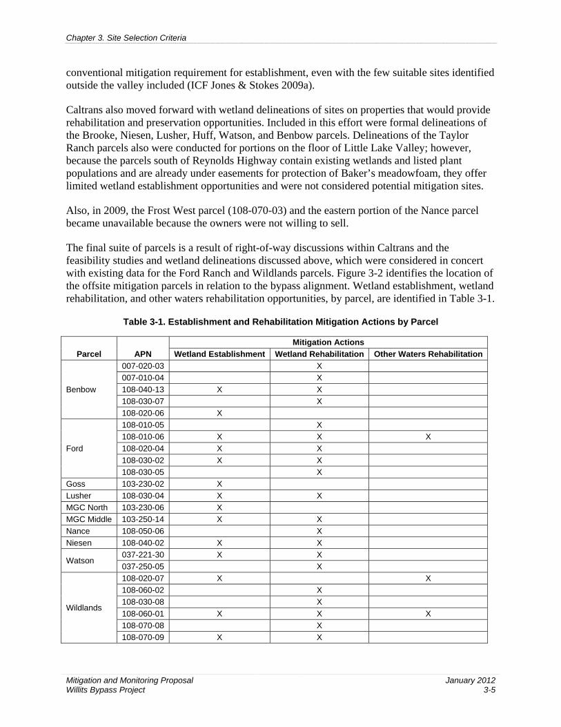
The final suite of parcels is a result of right-of-way discussions within Caltrans and the feasibility studies and wetland delineations discussed above, which were considered in concert with existing data for the Ford Ranch and Wildlands parcels. Figure 3-2 identifies the location of the offsite mitigation parcels in relation to the bypass alignment. Wetland establishment, wetland rehabilitation, and other waters rehabilitation opportunities, by parcel, are identified in Table 3-1.
Table 3-1. Establishment and Rehabilitation Mitigation Actions by Parcel
Parcel APN Mitigation Actions
Wetland Establishment Wetland Rehabilitation Other Waters Rehabilitation
Benbow
007-020-03 X 007-010-04 X 108-040-13 X X 108-030-07 X 108-020-06 X
Ford
108-010-05 X 108-010-06 X X X 108-020-04 X X 108-030-02 X X 108-030-05 X
Goss 103-230-02 X Lusher 108-030-04 X X MGC North 103-230-06 X MGC Middle 103-250-14 X X Nance 108-050-06 X Niesen 108-040-02 X X
Watson 037-221-30 X X 037-250-05 X
Wildlands
108-020-07 X X 108-060-02 X 108-030-08 X 108-060-01 X X X 108-070-08 X 108-070-09 X X

Chapter 3. Site Selection Criteria
Mitigation and Monitoring Proposal Willits Bypass Project
January 2012 3-6
As of the date of this MMP, the known opportunities for successful, self-sustainable wetland establishment have been exhausted. Caltrans has expended a great deal of effort and has acted diligently to identify suitable wetland establishment opportunities both in and outside the valley among landowners who have expressed willingness to participate in the mitigation process. In view of the challenges discussed above, Caltrans believed it would be in the best interest of the wetland resources to pursue mitigation on larger contiguous parcels in the valley using multiple strategies of establishment, re-establishment, and rehabilitation to work toward achievement of no net loss of functions and services of wetlands. USACE withdrew preservation as an option for compensatory mitigation, noting that the properties did not meet the criteria listed in the 2008 Mitigation Rule.
Caltrans worked in coordination with USACE to develop and refine the wetland and other waters mitigation actions presented in this MMP and the methods for determination of credits.
3.3 Mitigation Site Selection for Other Waters of the United States Rehabilitation
Preliminary discussions with USACE determined that implementation of riparian plantings and bank stabilization along various streams and improvements to fish passage would be acceptable mitigation for impacts on other waters in lieu of establishment of new other waters.
3.3.1 Onsite Mitigation for Other Waters
Fish passage repair increases the amount of available habitat in a stream system. If habitat abundance is the limiting factor for a migratory fish species, its population may rise in response to access to additional habitat. However, the population response to habitat gain also depends on numerous other factors, such as the quality and quantity of newly available habitat and the abundance and nature of the predators, competitors, and prey that reside there.
The primary objective for project design on both Haehl and Upp Creeks is to repair fish passage opportunities that currently are constrained or absent because of stream channel alignment or artificial barriers (e.g., culverts). These improvements are incorporated into the project design. Fish passage design elements will comply with guidelines established by NMFS and CDFG.
Fish passage design addresses one component of a healthy, sustainable, and functioning riparian habitat that supports anadromous fish. The design includes stabilization of streambanks using a variety of biotechnical measures, including rootwad revetment, live siltation, and vegetated RSP (Appendix E). Planting of containerized plants and cuttings from willows and cottonwoods will be included as part of the overall strategy to fully repair the riparian stream zone (Appendix E).
Obstacles or barriers currently exist in both creeks within Caltrans right-of-way. At Haehl Creek, the obstacle is a 72-inch corrugated metal pipe culvert with a 4- to 6-foot entryway jump at the downstream end. This culvert will be removed, and grade control structures will be located downstream of the culvert at appropriate heights and intervals for the distance necessary to stabilize the natural stream gradient (Appendix E). Also, in the Haehl Creek interchange, the

Outlet Ck.
Upp Ck.Old O
utlet Ck.
Davis Ck.
Davis Ck.
Outlet Ck.
Hearst Rd.
Valley Rd.Hearst Rd.
Center Valley Rd.
Center Valley Rd.
E. Hill Rd.
E. Commercial St.
Valley Rd.
Hea
rst W
illits Rd.
Reynolds Hw
y.
Eastsid e Rd.
20
101
101
101
Sherwood Rd.
Willits
00 0.5 1 1.5 2
Legend
Proposed Bypass Project Alignment
Section 404 Jurisdictional Mitigation Sites
Other Mitigation Sites
Base Map: USGS 1:24,000 series Willits, CA and Laughlin Ridge, CA topographic quadrangles
0 1Miles
2
Figure 3-2Proposed Bypass and O�site Mitigation Sites


Chapter 3. Site Selection Criteria
Mitigation and Monitoring Proposal Willits Bypass Project
January 2012 3-7
northbound on-ramp has a bridge that does not require any changes to the existing creek alignment but will have grade control structures placed to maintain the natural stream gradient (Appendix E). These structures also will allow the existing culvert belonging to the adjacent property owner to be backwatered if necessary.
The barrier along Upp Creek is a 10-by-5-foot box culvert. It appears to be in good condition and its size is adequate for necessary capacity, but it creates a fish barrier because of a combination of low flows and water levels, high velocity, and a slight entryway jump. This RCB culvert will be removed, and grade control structures will be located at appropriate heights and intervals for the distance necessary to stabilize the natural stream gradient (Appendix E).
The primary fish passage measure being proposed on both creeks are grade control structures that consist of rock sills and weirs. These structures are low-profile, typically constructed of boulders that span the width of the channel and are keyed into the channel bank. Collectively, the boulders are placed to concentrate the flows toward the center of the channel and away from streambanks. Rock weirs typically are arranged to form an upstream-pointing arch in plan view, with the lowest point (as seen in profile view) at the apex of the arch. They can be used to:
• Redirect the lowest point of the channel.
• Control channel alignment in confined areas or near infrastructure.
• Alter and maintain the width-to-depth ratio of the channel.
• Protect an eroding or sensitive streambank.
• Establish and maintain a scour pool for fish habitat.
• Concentrate low flow into a deeper, narrower channel to improve fish passage in otherwise flat-bottomed channels.
• Backwater the upstream channel to increase riffle water depth.
• Provide fish passage over barrier drops, provide water to diversions, or other uses.
• Encourage natural sorting of sediment at the pool outflow.
Although they are similar to drop structures in appearance, rock structures (which include rock weirs and sills) can withstand small shifts of material and continue to function as intended. They are made of individual rocks stabilized by the weight of the material and by contact with other rocks. Because they can withstand small deformations and continue to provide fish passage, these types of drop structures are better suited than rigid weirs to withstand downstream channel adjustments. Also, because of the inherent irregularities in the surface of rock structures, they generally provide increased hydraulic diversity and better passage performance than rigid weirs.
Both Upp and Haehl Creeks have unstable banks that increase sediment transport and bedload while reducing biological functions as they pertain to spawning habitat for anadromous fish. Although bank erosion is a natural and important geomorphic process in many disturbed systems, the erosion at both creeks appears to be occurring at an accelerated rate, especially at the Haehl Creek Interchange. The proposed bank protection at the creeks is designed to rehabilitate natural functions while enabling long-term natural stream processes to take place.

Chapter 3. Site Selection Criteria
Mitigation and Monitoring Proposal Willits Bypass Project
January 2012 3-8
3.3.2 Offsite Mitigation for Other Waters
3.3.2.1 Riparian Site Selection
The priority for selecting riparian corridor planting areas is to increase contiguous canopy cover longitudinally along the streams, as opposed to creating wider, intermittent corridors. Ample riparian plantings to satisfy mitigation needs for other waters, which also benefit federally listed fish, were identified along the various streams across the offsite mitigation parcels.
Long stream reaches supporting protected fisheries that would benefit from riparian plantings are present along both Davis and Outlet Creeks. Consultations with Craig Martz and Scott Harris of CDFG and Tom Daugherty of NMFS on April 18, 2008, indicated a preference for riparian plantings that serve as fisheries mitigation to occur on Outlet Creek because it supports populations of all three listed fish species (salmon and steelhead) potentially affected by the project. The longest reach of Outlet Creek available for mitigation traverses several of the John Ford and Wildlands parcels; accordingly, these properties have been selected to fulfill the fisheries mitigation requirements. In addition, the John Ford and Wildlands parcels are contiguous with other offsite mitigation parcels: Brooke, Lusher, Benbow, Nance, and Frost.
In a meeting held on May 14, 2009, Mr. Daugherty expressed a desire to reduce the width of riparian establishment and instead extend the riparian establishment in a more linear fashion to encompass more streambank. This approach to riparian establishment would have a more direct, positive effect on the quality of fish habitat.
In addition to planting along anadromous streams, riparian species and oaks will be planted adjacent to or near streams tributary to streams supporting anadromous fish to provide bank stabilization, stream shading, and a source of organic material for benthic invertebrates and salmonids, all of which will improve instream habitat.
3.3.2.2 Bank Erosion and Headcut Repair Site Selection
Numerous drainages throughout Little Lake Valley drain wet meadows to allow more efficient and extensive grazing of pastureland. These drainages are often interconnected and flow to the lowest point on the parcel, where they exit the parcel and flow onto another parcel or into an adjacent stream. In addition to draining surface water from the wet meadow more quickly than under natural conditions, the drainages also dewater adjacent wetland habitat, thereby potentially affecting adjacent wetland plant communities. Some disturbed drainages are unvegetated and show signs of channel bed and bank erosion (usually in the form of headcuts). Caltrans conducted an assessment of all the erosion sites located in the mitigation areas, which included inventory, prescription, and prioritization of mitigation actions that would reduce erosion and sedimentation in the Outlet Creek Basin.
Erosion features on the offsite mitigation properties that are contributing excessive sediment to and causing water quality degradation in channels and streams in Little Lake Valley have been prioritized for restoration as follows.

Chapter 3. Site Selection Criteria
Mitigation and Monitoring Proposal Willits Bypass Project
January 2012 3-9
1. The erosion feature contributes significantly to water quality degradation, as related to the contribution of excessive sediment from erosion of native soil.
2. The erosion feature can be restored without impacts on existing sensitive biological resources, including special-status plants and jurisdictional wetlands.
3. The erosion feature can be restored in coordination with planned mitigation actions.
4. The erosion feature can be restored using restoration approaches that are very constructable (i.e., construction of the feature is easy and access to it is direct).
5. The erosion feature’s restoration will create a synergy by combining site-specific restoration opportunities to create a major effect at a cumulative level. Priority is given to particular erosion sites because restoration actions at these sites can address immediately many of the priority items above. The following are considered to be four highest-priority bank erosion and headcut repair sites.
a. Ford (APN 108-010-06): There are three eroding bank sites on the east bank of Outlet Creek.
b. Frost Complex (APN 108-070-04): There are five headcut sites located in the northeast corner of the parcel—three are instream headcut sites, and two are upland headcut sites.
c. Lusher (APN 108-030-04): There are two headcut sites in the southwest corner of the parcel.
d. Benbow (APN 108-040-13): There is one headcut site in the southern end of the parcel.
Specific actions related to these drainages and headcuts for each of the erosion sites are described in Chapter 7, and the construction design drawings are provided in Appendix E.
3.4 Mitigation Site Selection for State-Listed Plants
Offsite mitigation parcels for the purpose of providing mitigation for state-listed plants were selected based on the presence of occupied or potential Baker’s meadowfoam and North Coast semaphore grass populations. The offsite mitigation parcels on which these species occur will be grazed and therefore do not contribute to the mitigation program for USACE jurisdictional wetlands.
3.4.1 North Coast Semaphore Grass
North Coast semaphore grass is a perennial species that spreads through underground rhizomes; although there is potential for its distribution to vary annually, the variation is not substantial. For this reason, only areas where the plant was observed during special-status plant surveys were considered during the determination of both impact and protection areas. Wetland mitigation parcels were selected based on the presence of occupied or potential North Coast semaphore grass populations.
Chapter 3. Site Selection Criteria
Mitigation and Monitoring Proposal Willits Bypass Project
January 2012 3-10
3.4.2 Baker’s Meadowfoam
Preservation is used for compensation for impacts on Baker’s meadowfoam because the establishment of populations of annual plant species is considered to have limited success. Because the distribution varies annually, Caltrans’ efforts to identify suitable offsite mitigation parcels included protocol-level surveys for Baker’s meadowfoam that focused on available parcels with either observed populations or suitable habitat (determined by soil type, elevation, and slope). The methods used to determine suitable habitat are presented in the MPR. Additional factors considered were contiguity with other mitigation properties, connectivity with other habitats, and percentage of the parcel supporting the species or its potential habitat.
Wetland mitigation parcels were selected based on the presence of occupied or potential Baker’s meadowfoam populations.

Mitigation and Monitoring Proposal Willits Bypass Project
January 2012 4-1
Chapter 4 Site Protection Instruments Caltrans has completed its purchase of the offsite mitigation properties. A conservation easement (CE) will be placed over the properties and will be held by CDFG. Caltrans will provide USACE with an opportunity to review the draft copies. The CEs will provide protection in perpetuity of the conservation values for which the properties were purchased. The CE will be tailored to ensure that the level of protection is adequate, while retaining the flexibility to carry out the necessary maintenance and management measures. All CE documents will be submitted to Mendocino County for recording no later than 1 year after the date the California Transportation Commission votes to approve the project (currently scheduled for February 2012).
Caltrans will provide an endowment to fund the initial startup costs and the long-term protection and management of the properties. A long-term management plan is provided in Chapter 11; it outlines the necessary management activities and will direct the land manager on how the properties will be maintained. An endowment calculation has been prepared and is found in Chapter 13.
For all offsite mitigation properties, CDFG will act as the endowment holder and CE holder/compliance monitor. MCRCD will act as the fee title holder following transfer of the titles from Caltrans and as the land manager. Fee title transfer will take place by the completion of construction of all mitigation. The endowment holder is responsible for holding and managing the endowment funds, the CE holder is the party to which the CE is granted, and the fee title holder legally owns the real property. The land manager is responsible for performing the actions set forth in the long-term management plan, adaptive management plan, and CE. The compliance monitor is responsible for ensuring that the land is being managed in accordance with the terms of the CE. In no case will the land manager also be designated the compliance monitor, nor will the fee title holder also be the CE holder; these two situations would create conflicts of interest.
The locations of onsite mitigation will not be included under CEs because permanent protection within the Caltrans right-of-way could interfere with maintenance of the roadway. However, resources within the Caltrans right-of-way still would be afforded protection under the CWA and other environmental laws.


Mitigation and Monitoring Proposal Willits Bypass Project
January 2012 5-1
Chapter 5 Baseline Information This chapter describes existing resources in the onsite mitigation area (i.e., within the bypass alignment footprint) and the offsite mitigation properties (i.e., adjacent to or away from the bypass alignment footprint). In a few cases, the bypass alignment footprint passes through offsite mitigation properties (i.e., portions of the Benbow, Brooke, Ford, Lusher, and Niesen parcels). Baseline information discussed in this chapter includes:
• Historical and existing surface water and groundwater hydrology.
• Historical and existing geology and geomorphology.
• Historical and existing vegetation.
• Historical and existing hydrology/topography.
• Soils and substrates.
• Jurisdictional wetlands and other waters of the United States.
• Protected fisheries.
• Riparian habitats.
• Listed plants (North Coast semaphore grass and Baker’s meadowfoam).
Note that this chapter first provides the discussion of historical and existing surface water and groundwater hydrology, geology, and geomorphology because the discussion relates to valleywide conditions. Subsequent discussion in the chapter is broken down into onsite mitigation area and offsite mitigation properties.
5.1 Valleywide Hydrology, Geology, and Geomorphology
5.1.1 Historical and Existing Surface Water Hydrology
Little Lake Valley contains many streams that convey water from the surrounding hills through the valley to Outlet Creek, which collects water from Little Lake Valley and eventually carries it to the Eel River. Generally, all of the streams are perennial upstream of Little Lake Valley and become intermittent in their lower reaches depending on the water-year type. The flow through Little Lake Valley is generally southeast to northwest.
Historically, during the wet season valley streams would overflow their banks and inundate the surrounding meadows, creating high-quality wetlands and forming a seasonal lake in the north end of the valley. Soil survey information from 1920 (Dean 1920) indicates that a lake historically formed at the northern end of Little Lake Valley during the rainy season, even during very low rainfall years. At the end of a series of heavy rainfall events in February 1915, the lake encompassed 1,875 acres and was 12 ft deep over a 300-acre area. At that time, the high water

Chapter 5. Baseline Information
Mitigation and Monitoring Proposal Willits Bypass Project
January 2012 5-2
mark of the lake was at the 1,330-ft contour, which historically would have flooded most of the northern half of the Ford property.
A lake no longer forms because the invert of Outlet Creek at the north end of Little Lake Valley has been lowered. Around the turn of the twentieth century valley settlers blasted natural rock formations downstream of the current US 101 alignment to allow the valley to drain more quickly. Other factors that affected flows and inundation levels and duration in the north end of the valley were the raising of US 101 above flood levels in 1964 and the construction of the current US 101 bridge crossing.
With the development of the city of Willits and agricultural conversion of the surrounding lands, many other drainage projects have been implemented throughout Little Lake Valley. These drainage projects often have resulted in incised streambeds, redirected creeks, ripped hardpan, and construction of numerous artificial drainage ditches. All these drainage features efficiently remove water from Little Lake Valley at an accelerated rate, quickly drying former wetland meadows to accommodate early grazing and hay production. A number of reservoirs1 in the surrounding hills further reduce wet-season flows through Little Lake Valley. Despite these extensive artificial alterations, a number of wetland habitats persist throughout Little Lake Valley.
5.1.1.1 Precipitation and Stream Discharge
Precipitation data were collected near Brooktrails during 1877−2002 and at the California Department of Forestry and Fire Protection’s (CalFire’s) Howard Forest near Davis Creek during 1988−2002. Almost all precipitation falls as rain. The Brooktrails site averaged 50 inches per year (in/yr) over the 125-year record. The late 1800s had the lowest average annual rainfall with less than 35 in/yr, and the 1950s and 1990s had the highest (60–65 in/yr). The Howard Forest site averaged 56 in/yr during the more than 15-year period, with a low of 35 in/yr and a high of 90 in/yr. Data from both sites were compared to known El Niño events. The highest rainfall events coincided with El Niño events: 1957–58; 1968–69; 1973–74; 1982–83; and 1997–98. El Niño events increased the average rainfall by 120% (LeDoux-Bloom and Downie 2008).
Streamflow data were collected from the U.S. Geological Survey (USGS) river gage in the Outlet Creek Basin near Longvale on Outlet Creek (USGS ID 11472200) during 1956−94; and a new gage installed at Lake Emily on Willits Creek in 2003 (USGS ID 11472160).
5.1.1.2 Flooding
The north coast of California is dominated by intense, short-duration rainstorms in winter, with peak flows that are among the highest on record for the western United States (Sommerfield et al. 2002 as cited in LeDoux-Bloom and Downie 2008). Outlet Creek flooded in 1907, 1938,
1 These include Lake Emily Dam (on Willits Creek with a surface area of 275 acre-feet [af]); Ada Rose Dam (on
Willits Creek with a surface area of 138 af); Boy Scout Camp Dam (on Boy Scout Creek with a surface area of 800 af); Pine Mountain Dam (on Moore Creek with a surface area of 45 af); Morris Dam (on Davis Creek with a surface area of 620 af); and Centennial Dam (on Davis Creek with a surface area of 512 af).

Chapter 5. Baseline Information
Mitigation and Monitoring Proposal Willits Bypass Project
January 2012 5-3
1950, 1955, and 1964, with the latter two floods causing severe damage. The 1955 flood deposited large amounts of debris and sediment that aggraded creeks throughout Little Lake Valley. During winter 1964, rain fell on the local snow pack and caused the release of a tremendous amount of water during a relatively short period, resulting in a significant increase in streamflow and velocity. High water in Outlet Creek washed away the railroad embankments along several sections of track during the 1964 flood. This flood was very damaging to the Eel River, its estuary, and smaller headwater basins, such as Outlet Creek (LeDoux-Bloom and Downie 2008).
Figure 5-1 shows the results of the flood frequency analysis for Outlet Creek near Longvale for the period of record. Peak annual discharge was fit using a Log-Pearson Type III distribution using standard procedures. It is interesting to note that the 1964 flood event had an estimated peak discharge of 77,900 cfs, which is the largest flow on record. The estimated 100-year event is 57,200 cfs and has an approximate return period of 385 years (P = 0.0026). Smaller, more recent significant rain events occurred in 1993, 1995, 1997, and 1998. Flood events are tightly correlated with El Niño events in California (LeDoux-Bloom and Downie 2008).
5.1.2 Historical and Existing Geology and Geomorphology
5.1.2.1 General Physiography—Outlet Creek Basin
Outlet Creek Basin in northern Mendocino County is part of the (Northern California) Coast Range Geomorphic Province. Outlet Creek Basin is the southwestern headwaters of the Eel River, the third largest river system in California. The Basin represents an area of approximately 160 square miles (mi2) (90,527 acres) or approximately 4% of the Eel River watershed. Outlet Creek is approximately 30 miles long from its headwaters to the Eel River and receives water from 12 tributary streams. The Basin is a combination of steep headwaters (greater than 20% gradient) that flow into Little Lake Valley and ultimately Outlet Creek. Small and large cobble and boulders dominate the high-transport reaches. Gravel and fine sediment, and in some places, bedrock, dominate the low-depositional reaches (primarily in Little Lake Valley).
Outlet Creek Basin has been divided into three separate subbasins for assessment and analysis purposes as described in the Outlet Creek Basin Assessment Report (LeDoux-Bloom and Downie 2008): the Northern, Middle, and Southern subbasins. The onsite mitigation area and offsite mitigation properties are in the Southern subbasin (Figure 5-2). Although the following description of geologic and geomorphic conditions covers the entire Outlet Creek Basin, its main focus is the Southern subbasin (and area of 64 mi2 [40,960 acres]).
5.1.2.2 Geology
The dominant geology in the Outlet Creek Basin is the Tertiary-Jurassic Central Belt,2 which is very soft to soft geology that is highly erodible. In Little Lake Valley, Quaternary alluvium is
2 Geologists have subdivided the Franciscan Complex into larger map units called belts and smaller map units
called terranes. The Tertiary-Jurassic Central Belt of the Franciscan Complex contains mélange (an accretionary assemblage) consisting of arkosic and lithic metasandstone and meta-argillite of pumpellyite and lawsonite metamorphic grade (high-pressure and relatively low-temperature blueschist facies) (McLaughlin et al. 2000).

Chapter 5. Baseline Information
Mitigation and Monitoring Proposal Willits Bypass Project
January 2012 5-4
dominant. On the southern boundary of Little Lake Valley, where alluvial fans are present, Pliocene-Pleistocene fill3 is present. Fine sediment is contributed consistently from Outlet Creek Basin into the Eel River.
Hillslope elevation ranges from 1,000 to 3,000 ft. Little Lake Valley has an approximate elevation of 1,280 ft and is considered a graben (an intermountain valley bound by faults and associated ridges on each side, locally widened into a basin or dropped downward in relation to adjacent portions).
5.1.2.3 Outlet Creek Basin Watershed Classification
Watershed Overview The Outlet Creek Basin stream network flows primarily in a northern direction and can be divided into three distinct segments:4 the source headwaters and the depositional valley floor (both part of the Southern subbasin), and the slower transport reaches downstream (also part of the Northern and Middle subbasins). The headwater streams include Berry, Davis, Baechtel, Broaddus, and Willits Creeks and the smaller perennial streams that flow into them.
The source-headwaters reaches occupy steeper and more confined forested valleys with bedrock structural control and fairly shallow alluvial deposits. This structural control creates fairly straight channel reaches with low sinuosity.
In the depositional valley floor, the stream valley is naturally unconfined with an essentially flat gradient and deep alluvial floor. Here the bedload is finer and channel sinuosity is higher; however, as subsequently discussed, artificial straightening has significantly decreased the sinuosity of many local channels.
There are slower transport reaches present downstream of Little Lake Valley. Stream gradient is variable, but is significantly steeper than that of the valley floor of Little Lake Valley and not as steep as the source-headwaters reaches. Specifically, Outlet Creek becomes confined and has a relatively steep gradient as it travels north along Sherwood Ridge and US 101. The gradient decreases above the confluence with Long Valley Creek, coinciding with a wider channel. Downstream of its confluence with Long Valley Creek, Outlet Creek turns east and is bound on its south side by Shimmin Ridge where it joins the Eel River.
Channel Form in Little Lake Valley Based on field observations (Appendix H) and the stream classification methods of Montgomery and Buffington (1998), the various watercourses in Little Lake Valley occur in an alluvial valley segment dominated by plane-bed and pool-riffle reaches. Plane-bed and pool-rifle reaches are
Metasandstone is locally interleaved with chert and metabasalt. Carbonate concretions and local chert beds contain microfossils that are Late Jurassic to Late Cretaceous in age.
3 Pliocene-Pleistocene fill consists of fine-grained lake deposits, coarser-grained alluvial gravel, and fine-grained fluvial overbank deposits (Woolace et al. 2005).
4 Bisson and Montgomery (1996) refer to such geomorphic regions as valley segments, whereby they share similar geomorphic properties as well as hydrologic and sediment transport characteristics.
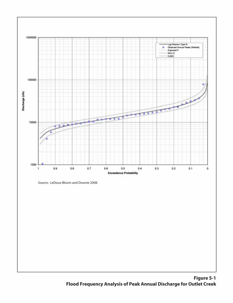
Figure 5-1Flood Frequency Analysis of Peak Annual Discharge for Outlet Creek
Source: LeDoux-Bloom and Downie 2008.
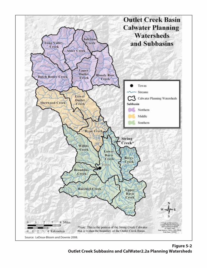
Figure 5-2Outlet Creek Subbasins and CalWater2.2a Planning Watersheds
Source: LeDoux-Bloom and Downie 2008.

Chapter 5. Baseline Information
Mitigation and Monitoring Proposal Willits Bypass Project
January 2012 5-5
transport-limited;5 therefore, the various watercourses in Little Lake Valley behave as response (or storage) channels, constantly adjusting their bed morphologies to water or sediment.
5.1.2.4 Historical Alterations to Hydrology and Geomorphology in Little Lake Valley
Before stream channels were relocated and dredged in the 1900s, Little Lake Valley functioned as a large, shallow lake and wetland until late spring or early summer, depending on the amount of rainfall of that given year (Dean 1920; LeDoux-Bloom and Downie 2008). Furthermore, the various drainages in Little Lake Valley lacked a discernible hydrologic connection to Outlet Creek. As described by Dean (1920):
An interesting and significant feature of the drainage of this Valley is that although all of the larger creeks have deep, wide channels that occupy a considerable portion of their respective valleys at the point where they enter the main valley, none of them are directly connected with Outlet Creek. The sudden decrease in the velocity of flow in these creeks which occurs upon their entering the main valley has caused them to deposit most of the suspended material which they carry, so that the channels become entirely filled by the time they have reached the flat portion known locally as the lake bed.
To a certain extent, this same process of channel filling occurs today, especially on smaller unnamed drainages and within wetlands on the floodplains. However, around the beginning of the last century, artificial channels were created by ox and plow to facilitate the draining of Little Lake into Outlet Creek for agricultural purposes, such as potato production, grazing (California Department of Water Resources 1965 as cited in LeDoux-Bloom and Downie 2008), and railroad construction. The largest channel appears to have been dredged from the confluence of Outlet Creek south through Little Lake where it joined Mill Creek. This channel was straightened and moved to the east to accommodate the railroad tracks (J. Ford, Ford Ranch, personal communication as cited in LeDoux-Bloom and Downie 2008).
One of the original channels (possibly the thalweg) through the lake is still visible and is referred to as the Outlet Creek overflow. This channel was later dredged straight south and merged with the confluences of Broaddus and Baechtel Creeks. This dredged channel was named Outlet Creek and is noted as such on maps today. Historical and current maps indicate that lower Berry and Davis Creeks were also straightened along property ownership lines to facilitate the drainage of Little Lake. By the end of the 1930s, Baechtel, Broaddus, Berry, and Davis Creeks were straightened, relocated, and/or leveed so the land area could be used for the expanding agricultural and transportation activities (LeDoux-Bloom and Downie 2008).
5 River segments can be classified into three classes based on their position within the watershed and the relative
ratios of transport capacity to sediment supply (Montgomery and Buffington 1998). Headwater source segments are typically transport-limited (often because of limited channel runoff) but offer sediment storage that is intermittently initiated under large flow events, debris flows, or other gravitational events (e.g., landslides). Transport segments are composed of morphologically resilient, supply-limited reaches (e.g., bedrock, cascade, step-pool) that rapidly convey increased sediment inputs. Response segments consist of lower-gradient, more transport-limited depositional reaches (e.g., plane-bed, pool-riffle, step-pool sequences) where channel adjustments occur in response to changes in sediment supply delivered from upstream.
Chapter 5. Baseline Information
Mitigation and Monitoring Proposal Willits Bypass Project
January 2012 5-6
These events have altered the hydrologic characteristics of Little Lake Valley and have enabled the widening of the channels. This has decreased the number and depth of pools and increased runoff, resulting in a general increase in streambank erosion. The levees along many of the channels have excluded overbank flows, except during large flood events greater than the 5- to 10-year peak discharge. The straightening, relocation, and levying of the channels in the lower parts of Davis, Baechtel, Broaddus, and Mill Creeks and the upper straightened part of Outlet Creek have caused the channels to become undefined and aggraded. This has led to subsurface flow that disconnects these streams from the rest of the watershed during the summer and early fall months (LeDoux-Bloom and Downie 2008).
5.1.2.5 Upstream Land Uses Affecting Geomorphic Characteristics of Little Lake Valley
Dams As mentioned previously, six reservoirs in the surrounding hills reduce wet-season flows through Little Lake Valley. These dams and associated reservoirs impound a total of 1,670 acre-feet per year (afy) and are filled by rain that usually falls November through February. The construction of these dams has resulted in a significant decrease in discharge, especially in the early 1990s after the construction of the Centennial Dam in 1989. In addition, the channels below the dams have become more incised, armored, and straighter and have experienced more bank erosion—all common effects created by dams (Knighton 1998; Thorne et al. 1996). Furthermore, other nonappropriated diversions of water upstream of Little Lake Valley also have reduced summer and fall flows necessary for juvenile salmonid survival (LeDoux-Bloom and Downie 2008).
Roads, Culverts, Bridges, and Weirs Roads have led to an increase in impervious surfaces, which has concentrated flows into the stream system. Concentrated flows have increased the erosive power of water, leading to accelerated streambank erosion and associated downstream sedimentation. Erosion features associated with culverts include headcuts in the upstream direction, scour areas in the downstream direction, and/or eroding gullies in either direction. All of these erosion features were observed in the offsite mitigation parcels (Appendix H). Bridges tend to constrict water movement in the channel, thereby increasing stream energy and accelerating streambank erosion, especially in the vicinity of the bridge itself. Weirs can increase erosion and incision locally through hyper-concentration of flow (Doyle et al. 2000).
Timber Harvesting The lack of erosion control facilities throughout areas of Little Lake Valley and the Outlet Creek Basin in general, coupled with the uncontrolled installation of fills and failure to remove fills adjacent to watercourses, left the land vulnerable to large storm events. Intense, prolonged runoff during large storm events in the mid 1950s and 1960s caused erosion from channel incision, slides, and washing of soil and debris into watercourses. The residual effects still can be seen in some areas of Little Lake Valley. Anecdotal observations suggest that significant logjams in several streams coincided with these large storm events; for example, at least one logjam occurred on Willits Creek between 1957 and 1960 that was approximately 50 ft wide and 300 ft long. At the south end of Little Lake Valley, sediment accumulated near the confluences of Haehl, Baechtel, and Broaddus Creeks. The creeks were straightened, channelized, and leveed along property lines and relocated to flow into a single stream called Outlet Creek, which flows

Chapter 5. Baseline Information
Mitigation and Monitoring Proposal Willits Bypass Project
January 2012 5-7
into and out of Little Lake Valley (J. Ford, Ford Ranch, personal communication as cited in LeDoux-Bloom and Downie 2008). Although timber harvesting practices are more environmentally sensitive today than in the past, sedimentation from timber harvesting practices is still a problem in the Outlet Creek Basin (LeDoux-Bloom and Downie 2008).
Vegetation Removal Vegetation removal from channel clearing or through grazing, logging, or conversion to agricultural and developed lands can reduce channel and bank roughness and therefore increase flow velocities. As mentioned previously, an increase in concentrated flows has increased the erosive power of water, leading to accelerated streambank erosion (and loss of streamside vegetation) and downstream sedimentation.
5.1.2.6 Geomorphic Characteristics of Little Lake Valley
Caltrans assessed existing erosion sites at the offsite mitigation properties in May 2010 (California Department of Transportation 2010; Appendix H). The assessment documented existing erosion points (e.g., headcuts) and linear (e.g., eroding banks) features on upland and instream areas and evaluated these features in terms of contribution of sediment to swales and creeks, effects on adjacent sensitive resources, and ease of constructability/access to restore the erosion feature. General information on the geomorphic characteristics of Little Lake Valley also was noted as part of this effort.
The following geomorphic characteristics have been synthesized from the erosion site assessment and an accompanying literature search to identify the processes currently operating in Little Lake Valley, to understand the geomorphic landforms on the offsite mitigation properties, and to identify the likely geomorphic effects associated with mitigation efforts.
Substrate Composition and Embeddedness Caltrans did not collect data on substrate composition and embeddedness as part of the erosion site assessment. However, visual inspection of the channel beds on the offsite mitigation properties suggests that fine sediment (silts and sands) dominates the channel bed sediment. However, in other areas of the channels (such as upper Davis and Old Outlet Creeks), gravels (and associated extensive point bar development) are also present.
Based on the Outlet Creek Basin Assessment Report (LeDoux-Bloom and Downie 2008), findings relevant to substrate composition and embeddedness at the offsite mitigation properties include:
• Fine sediment deposits in low-gradient reaches contribute to shallow pool depth and small spawning substrate (and can lead to an increase in flooding through loss of channel capacity, which in turn exacerbates bank erosion).
• Embeddedness levels are unsuitable in many streams (which signals fine-sediment deposition from bank and near-bank processes).
• The six dams have significantly decreased downstream gravel recruitment.
Chapter 5. Baseline Information
Mitigation and Monitoring Proposal Willits Bypass Project
January 2012 5-8
Bank Instability and Bank Characteristics Bank erosion has been identified as the most significant contributor of excess sediment in the Outlet Creek Basin (LeDoux-Bloom and Downie 2008). Bank composition ranges from unconsolidated to consolidated silt, sand, and gravel. In general, in riverine environments where no other significant land use practices that destabilize and introduce sediment to the surrounding topography occur, eroding banks are generally thought to be the principal source of excessive local sedimentation (Hooke 1980; Lawler 1992, 1995; Lawler et al. 1997; Rosgen 1996). In addition, much of Little Lake Valley has been used for livestock grazing. Livestock grazing in riverine environments also can lead to bank erosion as a result of trampled ground that becomes compacted enough to prohibit the establishment of vegetation but not so much as to prohibit the contribution of soil particles to the water column from high-velocity flows (Myers and Swanson 1993). Bank erosion from steep headwater source streams and streams in Little Lake Valley likely delivers much of the fine sediment in the Outlet Creek Basin (LeDoux-Bloom and Downie 2008).
Caltrans analyzed bank erosion on the offsite mitigation properties as part of the 2010 erosion assessment in the Outlet Creek Basin (Appendix H). Eleven eroding bank sites were identified on the offsite mitigation properties (an area that encompasses approximately 2,089 acres). Three bank erosion sites (on the Ford parcel 108-010-06) were observed to have the potential to provide excessive sedimentation to downstream channels. Each of these sites is an instream eroding bank that occurs on Outlet Creek in the center of the parcel, and all three sites are similar because they have unstable, mostly unvegetated right (i.e., east) cutbanks created by convergence flow on the riffle/gravel bar complex opposite the cutbank. The presence of these gravel bars and opposite bank erosion indicate that Outlet Creek is trying to locally increase its sinuosity through lateral migration (see the discussion under Channel Pattern below). The banks are approximately 6 ft tall from the toe of the bank. Lateral migration and upstream fluvial scour, combined with direct trampling by livestock, likely have initiated these erosion features. All three erosion sites appear unstable, as evidenced by active slumping.
Other sites where unstable streambanks were documented but do not appear to be contributing excessive sedimentation include two sites on Benbow parcel 108-040-13 (with lengths of 64 and 20 ft); two sites on Benbow parcel 007-020-03 (with lengths of 30 and 820 ft); one site on Ford parcel 108-020-04 (with a length of 35 ft); one site on Ford parcel 108-030-05 (with a length of 35 ft); and two sites on the Wildlands parcel 108-060-01 (with lengths of 90 and 105 ft). In addition, six gullies experiencing either continuous or discontinuous erosion as evidenced by incision, localized slumping, or other erosion features were identified on Taylor parcels 037-221-68 and 037-240-41.
Most of the channels and streams in the offsite mitigation parcels appeared to have adequate vegetation cover, and the small amount of eroding banks in proportion to the total linear feet of streams in the offsite mitigation parcels do not point to large-scale bank instability. However, high erosion potential combined with flashy instream conditions on noncohesive banks either devoid of vegetation or containing only shallow-rooted or annual plant species has created streambanks that have the potential to erode easily (LeDoux-Bloom and Downie 2008).

Chapter 5. Baseline Information
Mitigation and Monitoring Proposal Willits Bypass Project
January 2012 5-9
Pool, Riffle, and Run Frequency (Habitat Complexity) Caltrans did not collect habitat complexity data as part of the erosion site assessment (Appendix H). However, visual inspection of the channels on the offsite mitigation properties suggests that most habitat units consist of long runs dominated by fine sediments (silts and sands). Shallow pool depths were noted, and riffles (although present near gravel bars) were not abundant. Woody debris influence is generally low (except in upper Davis and Old Outlet Creeks).
Channel Pattern A review of historical aerial photography, and the description in the 1920 Soil Survey of the Willits Area, California (Dean 1920), indicate that channel sinuosity was historically much greater in Little Lake Valley than today, and that some of the channels were anabranching (multithread). Today, channel pattern can be described as straight and single-thread. As described above, channel straightening has led to many undesired consequences for the channels in Little Lake Valley (e.g., exacerbated channel incision and bank erosion). Most of the channels on the offsite mitigation properties are straight (sinuosity value of 1). Upstream of the offsite mitigation properties, channel sinuosity increases and ranges from slightly sinuous (sinuosity value of 1.1–1.3) to sinuous (sinuosity value of 1.4–1.7).
Channels in Little Lake Valley are unconfined by hillslopes; however, almost all channels are incised (see discussion below). As a result of channel straightening, it is likely that some of the channels are experiencing continued incision and lateral migration. An example of this occurs on Outlet Creek on Ford parcel 108-010-06, where the presence of gravel bars results in opposite bank erosion, suggesting that Outlet Creek is trying to locally increase its sinuosity through lateral migration.
Degree of Incision and Stage of Channel Evolution Channel incision has several negative consequences for stream channels. First, incision leads to deepened channels. This deepening limits channel-floodplain interaction, thereby increasing such variables as unit stream power (Brizga and Finlayson 1990). An increase in unit stream power has the potential to further increase the instability of streambanks because of increased shear stress on those banks. Limited channel-floodplain interaction also restricts ecological interactions between the channel and the floodplain (Doyle et al. 2000). Second, incised channels further increase the flashy response of channels in semi-arid environments where infrequent events dominate geomorphic effectiveness (Wolman 1988). Third, channel habitat units, such as pool-riffle sequences, are rare in incised channels, and those that do exist do so for only limited periods (Shields et al. 1988). Last, the increased depth of flow associated with incision, coupled with an increased flashy regime, results in bed armoring and a decreased frequency of bed mobilization (Doyle et al. 2000).
Based on field observations (Appendix H), most of the channels on the offsite mitigation properties are incised. Degree of incision is high because of the presence of steep, sometimes unstable, and near vertical streambanks adjacent to floodplains. In addition, some streambanks (e.g., the lower portion of Davis Creek) are denuded of vegetation, an indication of little or no hydrologic interaction between the floodplain and the channel under most flows, which generally denotes incision. Finally, the lack of splay deposits; vegetation with a smoothed, flooded appearance in the downstream direction; and natural levee development also were noted as indications of incision.
Chapter 5. Baseline Information
Mitigation and Monitoring Proposal Willits Bypass Project
January 2012 5-10
In summary, excessive erosion and downstream deposition appear to be influencing channel form, and at present there is no balance between sediment supply and water discharge, as noted by excessive sedimentation. However, no site-specific data were evaluated, and future trends of channel incision would require repetitive cross-sectional and longitudinal profile surveys.
5.1.3 Groundwater Hydrology
Little Lake Valley is underlain by a layer of Holocene alluvium estimated to be a maximum of 250 ft deep. The alluvium is composed of silt, clay, gravel, and sand. There is a layer of continental basin deposits under the alluvium and Franciscan Complex bedrock under the continental basin deposits.
The alluvium layer is the most productive aquifer for groundwater wells because it generally has relatively high porosity and permeability (Farrar 1986). The presence of sheets of fine-grained sediments in the alluvium causes much of the aquifer to be confined or semiconfined (California Department of Water Resources 2004). While the city of Willits obtains its water from Morris Reservoir, groundwater wells are used for agriculture and residential use outside of Willits (Farrar 1986).
The California Department of Water Resources (DWR) (2010) reports well depth and elevation measurements from five wells in Little Lake Valley (Figure 5-3). Wells 1 and 2 are near Willits adjacent to the mountains on the west side of Little Lake Valley. Wells 3, 4, and 5 are toward the center of Little Lake Valley to the southeast, east, and northeast of Willits, respectively. Measurements from these wells indicate that groundwater could be close to the ground surface (i.e., shallow), particularly in the wells located away from the edges of Little Lake Valley (wells 3, 4, and 5). This shallow groundwater supports many depressional wetlands that occur throughout Little Lake Valley.
Groundwater levels measured in wells represent piezometric water surface levels. For an unconfined aquifer, the well elevations are roughly the same as the elevation of the top of the aquifer, but for confined aquifers, well elevations can be higher than the elevation at the top of the aquifer. As a result, it is difficult to determine with certainty whether the groundwater supporting wetlands in Little Lake Valley is perched on impermeable layers above the main aquifer or whether it represents the top portion of the main aquifer. Regardless of the mechanism (perched water versus main aquifer), the abundance of wetlands in Little Lake Valley indicates shallow groundwater levels occur and are available to support existing and proposed established wetlands.
The DWR well data indicate that groundwater elevations can fluctuate seasonally from 5 to 15 ft (California Department of Water Resources 2010) (Figure 5-3). Seasonal fluctuations in groundwater level result primarily from pumping and precipitation (Farrar 1986), although other factors such as groundwater movement to and from streams, evapotranspiration, and recharge from irrigation play a role. Wells 2, 3, and 4 are no longer in use, so the fluctuations in their levels (Figure 5-3) are not a result of pumping of these wells, although pumping at other wells could be affecting the levels in wells 2, 3, and 4. The well data also indicate that groundwater levels in Little Lake Valley can decrease slightly during periods of drought. For example, well-

Dep
th (f
eet)
Year
Figure 5-3Depth to Groundwater in Five Wells Located in Little Lake Valley
Data source: California Department of Water Resources 2010.
Well 1 (State Well #18N13W18L001M)Well 2 (State Well #18N13W18E001M)Well 3 (State Well #18N13W20H004M)Well 4 (State Well #18N13W17J001M)Well 5 (State Well #18N13W08L001M)
LEGEND


Chapter 5. Baseline Information
Mitigation and Monitoring Proposal Willits Bypass Project
January 2012 5-11
level recovery was slightly reduced in some wells during some dry winters such as 1977. However, in general there has been little change in well levels from year to year, suggesting that to the extent that the main aquifer supports wetlands, groundwater is usually available to support wetland hydrology.
The presence of groundwater discharge at a large marsh at the north end of Little Lake Valley, located where water leaves the valley via Outlet Creek, further indicates that groundwater levels are close to the soil surface. During particularly wet winters, the marsh becomes a shallow lake as a result of groundwater and surface water inflow (Farrar 1986).
5.1.3.1 Summary of Winter 2010–2011 Groundwater and Wet Meadow Inundation Sampling
This section summarizes the results of groundwater monitoring and wet meadow inundation surveys. Groundwater monitoring conducted during at monthly intervals from December 2010 through March 2011. In April and May 2011, data were collected twice a month. Wet meadow inundation surveys were performed from December 2010 through May 2011. This monitoring was performed as part of a baseline survey performed for biological and physical resources in Little Lake Valley and on the mitigation parcels. The complete monitoring results are contained in the Draft Monitoring Reporting Program (MRP)/Incidental Take Permit (ITP) Baseline Conditions Report (California Department of Transportation 2011).
Groundwater Monitoring Groundwater wells were installed in representative wet meadows on parcels in the bypass area and the mitigation area. In the impact area, some groundwater wells were installed in wet meadows in the haul road alignment to determine whether project impacts from the haul roads would be temporary, as expected, or permanent. In the mitigation area, groundwater wells were installed in representative wet meadows on each parcel to capture variations in soils and topography; however, where soil and topography conditions are relatively homogenous across parcels (e.g., Benbow parcels), groundwater wells were not installed on each parcel. Groundwater wells also were installed near sites where wetland establishment is proposed.
Shallow groundwater with a seasonal variation (highest in spring, lowest in fall) is a dominant feature of the valley. Historical records from a few wells near Willits indicate water levels fluctuate by about 5 to 10 ft from spring to summer in several wells located along the creeks in the valley. This shallow groundwater helps maintain water in the surface soils and extends the period of soil saturation after the seasonal rainfall ends in May or early June. Given the abundance of wetlands in the valley, along with the moderately permeable soil, it seems likely that the shallow groundwater (water table) remains close to the surface across most of the valley during the rainy season. The shallow groundwater then slowly drains to a depth of 5–10 ft through seepage to the creek channels.
Many of the shallow groundwater wells indicated that the soil profiles were nearly saturated within 6 inches of the surface. A few indicated relatively dry conditions on the first survey in mid-December. Although the cumulative rainfall was about 20 inches by December 15, the shallow groundwater had not yet saturated the soils in most of the wells on the Benbow parcels. All wells on the Ford parcels generally were saturated in mid-December. Nearly all of the wells

Chapter 5. Baseline Information
Mitigation and Monitoring Proposal Willits Bypass Project
January 2012 5-12
showed saturated soil conditions in the late March and early April surveys. All Benbow parcel wells indicated that the shallow groundwater had declined to below the well depth (30 inches) by the end of April. All Benbow parcel wells are along the Baechtel Creek and Outlet Creek channels. The creek channels are relatively deep (incised) along these parcels, and the shallow groundwater could drain several feet as seepage to the creek channels after the high creek flows decrease to baseflow conditions. The seepage rate at these locations or on other wet meadows at the offsite mitigation areas adjacent to creek channels is dependent on localized soil conditions and is expected to vary depending on location. For example, soil surveys performed for proposed Group 2 wetland establishment site along Outlet Creek and Davis Creek indicated that soil textures and permeability in upland areas that are proposed to be lowered for wetland establishment had soil characteristics similar to adjacent wet meadows and therefore would not serve as a “drain” to the wetland.
As part of the evaluation of North Coast semaphore grass habitat in the valley, 20 shallow groundwater monitoring wells were installed in the vicinity of semaphore grass habitat (eight wet meadow sites, five riparian sites, and seven upland sites). The data from these shallow wells are indicative of the shallow groundwater variations that are expected at other wetlands parcels in the valley. Groundwater levels were monitored intermittently from April 24, 2010, to June 27, 2010. Data from these wells indicate that the shallow groundwater elevations increased with rainfall and decreased at a similar rate after rainfall ended for the year. The groundwater elevations generally increased between April 24, 2010, and April 29, 2010 in response to about 2.25 inches of rainfall. Groundwater elevations then decreased between April 29 and May 19 (rainfall of about 1 inch). Groundwater elevations increased again between May 19 and June 7 (rainfall of about 2.5 inches) and then decreased from June 7 to June 27.
The City of Willits also installed shallow monitoring wells along Outlet Creek where they irrigate the wet meadow with effluent during the summer and where they constructed treatment/storage wetland ponds in 2010 on the other side of Outlet Creek from the existing treatment plant (Jeff Anderson and Associates 2007). These shallow wells indicate a similar pattern of groundwater levels increasing to near the surface and saturation of the soils throughout the wet season, with a slowly declining water elevation of 5 to 10 ft during the summer and fall. Some of the City’s parcels have shallow groundwater pumps for summer spray irrigation, but pumping of the groundwater is not extensive, and the shallow groundwater elevations below most of the valley slowly decrease as the soils and shallow groundwater drain to the stream channels during the summer and fall.
Wet Meadow Inundation Monitoring Inundation of the wet meadow portion of each parcel in the impact and offsite mitigation areas was monitored through field measurement of the surface area of ponding. Measurement included the surface area extent, depth, and duration of ponding. A minimum area of 400 ft2 (20 ft x 20 ft) with a minimum water depth of 4 inches was used for mapping the inundation of each parcel. The surface area extent data were collected using a sub-meter-precision GPS receiver. Water depth was measured at several points in each inundated wetland area. Inundation data were collected from December 2010 through March 2011 at monthly intervals. In April and May 2011, data were collected twice a month. Duration was estimated from a combination of inundation maps and streamflow depth records from adjacent stream stations.

Chapter 5. Baseline Information
Mitigation and Monitoring Proposal Willits Bypass Project
January 2012 5-13
The surveyed areas represent approximately 25% of the total area in the valley below the 1,400-ft elevation contour. The total surveyed area was approximately 1,500 acres, of which 1,037 acres (70%) were classified as jurisdictional wet meadow. Generally, the January 2011 survey recorded the smallest inundated wet meadow acreage (approximately 20% of total wet meadow on the parcels). The December survey recorded approximately 325 acres of inundated wet meadow (31% of total wet meadow on the parcels). The February survey recorded approximately 407 acres of inundated wet meadow (39% of total wet meadow on parcels), and the March survey indicated nearly 840 acres of inundated wet meadow (81% of total wet meadow on the parcels). Although the monthly surveys were not scheduled to coincide with rainfall conditions, the four surveys indicated that a considerable portion of the wet meadows are inundated for weeks or months during the wet season.
5.2 Bypass Alignment Footprint Impact Area
The project entails construction of a new four-lane segment of US 101. The new segment will be 5.6 miles long beginning 2.0 miles south of Willits and ending 1.0 mile north of Willits. The bypass alignment footprint’s permanent and temporary impact areas will encompass 236.06 acres, including the roadway, construction access roads, staging areas, and the Oil Well Hill borrow site (12.15 acres). The bypass alignment footprint is east of Willits, and generally crosses agricultural areas in Little Lake Valley. Construction of the bypass will affect the following sensitive biological resources:
• Listed fish: SONCC coho salmon, California coastal Chinook salmon, and northern California steelhead.
• Listed plants: North Coast semaphore grass and Baker’s meadowfoam.
• Riparian habitat encompassing protected fisheries resources (Category I Riparian Corridors).
• Jurisdictional wetlands and other waters of the United States.
• Riparian woodlands (Categories II and III Riparian Corridors).
• Oak woodlands and associated uplands/grasslands.
Sections 5.2.1 through 5.2.7 describe existing sensitive biological resources within the bypass alignment footprint (i.e., the onsite mitigation area). Appendix B provides maps of onsite sensitive biological resources.
5.2.1 Historical and Existing Vegetation
The native vegetation of Little Lake Valley has been affected primarily by land conversion for agricultural production. Large areas of open meadows that once consisted of high-quality wet meadows and vernal pools have been converted into pastures and hay production fields. These wet meadows currently support Kentucky bluegrass, tall fescue, spreading rush, and several sedge species. The vernal pools currently support Davy’s semaphore grass (CNPS List 4),
Chapter 5. Baseline Information
Mitigation and Monitoring Proposal Willits Bypass Project
January 2012 5-14
Pacific foxtail, and pennyroyal. Tall fescue, Italian ryegrass, and nonnative clovers (i.e., white clover, rose clover, and shamrock) dominate the drier transition areas of these meadows.
Streams, swales, and artificial drainages drain water from the meadows and support riparian forest habitat throughout the bypass alignment footprint. In these areas, white alder, Oregon ash, and valley oak dominate the canopy, while arroyo willow and Himalayan blackberry form the shrubby understory prevalent along open banks. In the wetter areas of the north part of Little Lake Valley, Oregon ash forests are dominant, with only occasional valley oaks and an understory of California blackberry, red-twig dogwood, cow parsnip, and spreading gooseberry. Freshwater marsh habitats east of existing US 101 at the northern end of the bypass alignment footprint support tule, Nebraska sedge, western goldenrod, Baltic rush, slender hairgrass, soft rush, dense sedge, and creeping bentgrass.
5.2.2 Historical and Existing Hydrology/Topography
The project will affect a predominantly lowland area on the western side of Little Lake Valley. This area contains many streams that convey water from the surrounding hills through Little Lake Valley to Outlet Creek, which collects water from Little Lake Valley and eventually carries it to the Eel River. Flow through Little Lake Valley is generally southeast to northwest. The streams that will be affected by the bypass alignment footprint are Haehl Creek, Baechtel Creek, Broaddus Creek, Mill Creek, and Upp Creek. All of these streams are intermittent.
Historically, during the wet season, these streams would overflow their banks and inundate the surrounding meadows, creating high-quality wetlands. With the development of the city of Willits and agricultural conversion of the surrounding lands, many drainage projects have been implemented throughout Little Lake Valley. These drainage projects have often resulted in incised streambeds, redirected creeks, ripped hardpan, and construction of numerous artificial drainage ditches. All these drainage features efficiently remove water from Little Lake Valley at an accelerated rate, quickly drying former wetland meadows to accommodate early grazing and hay production. A number of reservoirs6 in the surrounding hills further reduce wet-season flows through Little Lake Valley. Despite these extensive artificial alterations, a number of wetland habitats persist throughout the bypass alignment footprint.
5.2.3 Soils/Substrates
The Natural Resources Conservation Service (NRCS) Eastern Mendocino County Soils Survey was used to analyze soils in the bypass alignment footprint (Figures 5-4a through 5-4h). Hydric status for map units ranged from nonhydric to partially hydric, while the dominant drainage class ranged from very poorly drained to well-drained.
6 These include Lake Emily Dam (on Willits Creek with a surface area of 275 af); Ada Rose Dam (on Willits Creek
with a surface area of 138 af); Boy Scout Camp Dam (on Boy Scout Creek with a surface area of 800 af); Pine Mountain Dam (on Moore Creek with a surface area of 45 af); Morris Dam (on Davis Creek with a surface area of 620 af); and Centennial Dam (on Davis Creek with a surface area of 512 af).

Walker Rd
£¤101
221215224
Q: \
PR
OJE
CTS
\ C
ALT
RA
NS
\ 00
543_
09_W
ILLI
TS
_FR
OM
_UR
S \
MA
PD
OC
\ A
PP
EN
DIX
_B \
WIL
LITS
_HM
MP
_AP
PE
ND
IX_B
_SO
ILS
_V4.
MX
D S
S (
02-1
9-10
)
0 1000
Scale in Feet
¯
Proposed Willits Bypass Project
FigureSoil Types within the Proposed
Bypass Project Footprint
SSURGO Map Unit
Permanent Impact Boundary
Temporary Impact Boundary
Road
Map Unit Symbol Map Unit Name
110 CASABONNE-WOHLY LOAMS, 30 TO 50 PERCENT SLOPES115 COLE CLAY LOAM, 0 TO 2 PERCENT SLOPES123 FELIZ LOAM, 0 TO 2 PERCENT SLOPES124 FELIZ LOAM, 2 TO 5 PERCENT SLOPES127 FLUVAQUENTS, 0 TO 1 PERCENT SLOPES128 GIELOW SANDY LOAM, 0 TO 5 PERCENT SLOPES133 HAPLAQUEPTS, 0 TO 1 PERCENT SLOPES
155KEKAWAKA-CASABONNE-WOHLY COMPLEX, 30 TO 50 PERCENT SLOPES
210 URBAN LAND
213WOHLY-CASABONNE-PARDALOE COMPLEX, 50 TO 75 PERCENT SLOPES
215XEROCHREPTS-HAPLOXERALFS-ARGIXEROLLS COMPLEX, 9 TO 30 PERCENT SLOPES
216XEROCHREPTS-HAPLOXERALFS-ARGIXEROLLS COMPLEX, 30 TO 50 PERCENT SLOPES
221 YOKAYO SANDY LOAM, 0 TO 8 PERCENT SLOPES
224YOKAYO-PINOLE-PINNOBIE COMPLEX, 0 TO 15 PERCENT SLOPES
236 WATER
£¤101
¬«20
£¤101
Oil Well Hill Borrow Site
1:150,000
¯
KEY
5-4a
SSURGO Map Unit Label Description178 Map Unit Symbol

Walker Rd
£¤101
Ditch
123221128
123
215
124
Q: \
PR
OJE
CTS
\ C
ALT
RA
NS
\ 00
543_
09_W
ILLI
TS
_FR
OM
_UR
S \
MA
PD
OC
\ A
PP
EN
DIX
_B \
WIL
LITS
_HM
MP
_AP
PE
ND
IX_B
_SO
ILS
_V4.
MX
D S
S (
02-1
9-10
)
0 1000
Scale in Feet
¯
Proposed Willits Bypass Project
FigureSoil Types within the Proposed
Bypass Project Footprint
SSURGO Map Unit
Permanent Impact Boundary
Temporary Impact Boundary
Road
Map Unit Symbol Map Unit Name
110 CASABONNE-WOHLY LOAMS, 30 TO 50 PERCENT SLOPES115 COLE CLAY LOAM, 0 TO 2 PERCENT SLOPES123 FELIZ LOAM, 0 TO 2 PERCENT SLOPES124 FELIZ LOAM, 2 TO 5 PERCENT SLOPES127 FLUVAQUENTS, 0 TO 1 PERCENT SLOPES128 GIELOW SANDY LOAM, 0 TO 5 PERCENT SLOPES133 HAPLAQUEPTS, 0 TO 1 PERCENT SLOPES
155KEKAWAKA-CASABONNE-WOHLY COMPLEX, 30 TO 50 PERCENT SLOPES
210 URBAN LAND
213WOHLY-CASABONNE-PARDALOE COMPLEX, 50 TO 75 PERCENT SLOPES
215XEROCHREPTS-HAPLOXERALFS-ARGIXEROLLS COMPLEX, 9 TO 30 PERCENT SLOPES
216XEROCHREPTS-HAPLOXERALFS-ARGIXEROLLS COMPLEX, 30 TO 50 PERCENT SLOPES
221 YOKAYO SANDY LOAM, 0 TO 8 PERCENT SLOPES
224YOKAYO-PINOLE-PINNOBIE COMPLEX, 0 TO 15 PERCENT SLOPES
236 WATER
£¤101
¬«20
£¤101
Oil Well Hill Borrow Site
1:150,000
¯
KEY
5-4b
SSURGO Map Unit Label Description178 Map Unit Symbol
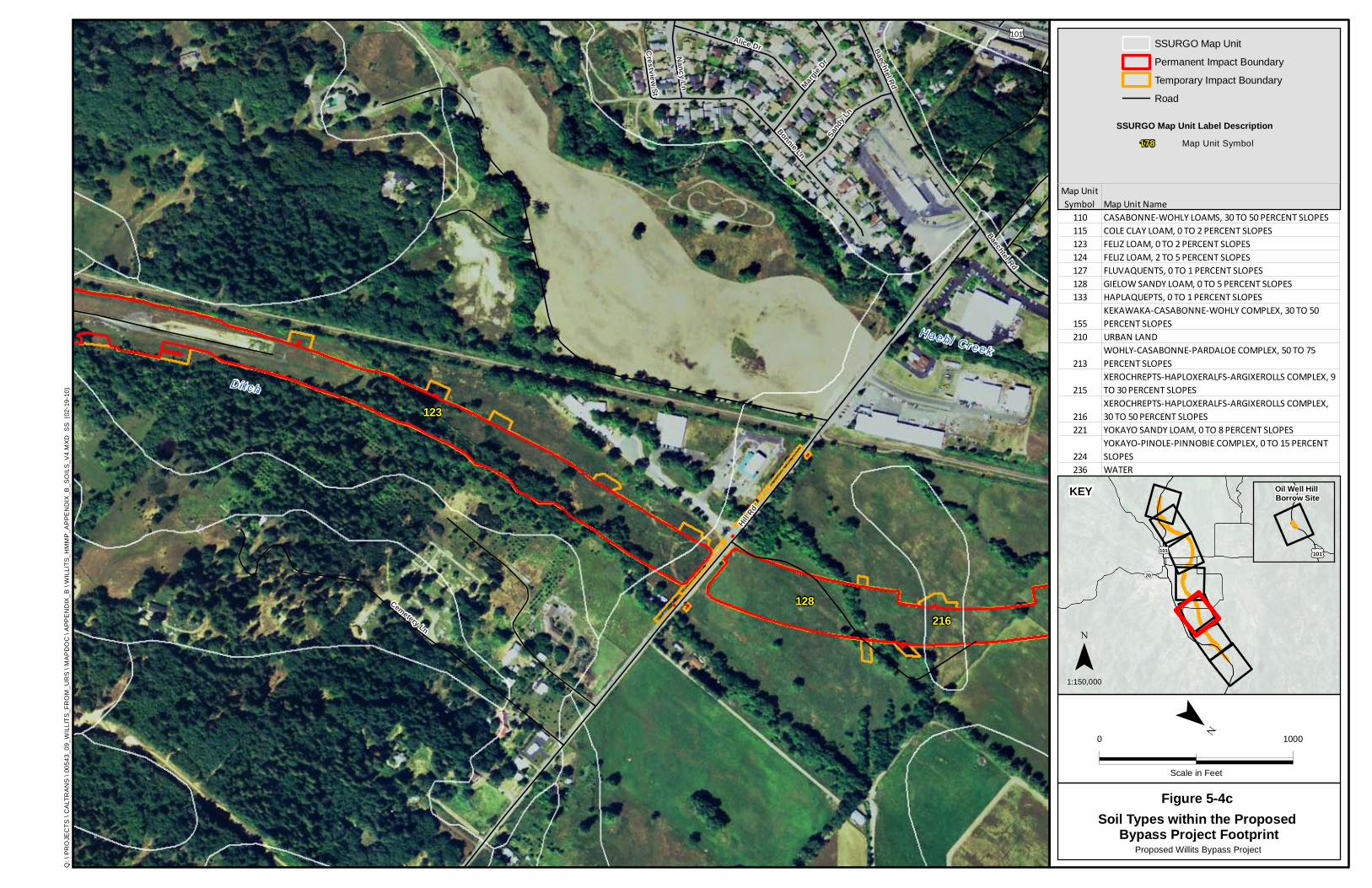
Crestv iew St
Nancy Ln
Baechtel Rd
Sand
y Ln
Margie Dr
Alice Dr
Bonnie Ln
Cemetery Ln
Baechtel Rd
Hill Rd
£¤101
Haehl C reek
Di tch
128216
123
Q: \
PR
OJE
CTS
\ C
ALT
RA
NS
\ 00
543_
09_W
ILLI
TS
_FR
OM
_UR
S \
MA
PD
OC
\ A
PP
EN
DIX
_B \
WIL
LITS
_HM
MP
_AP
PE
ND
IX_B
_SO
ILS
_V4.
MX
D S
S (
02-1
9-10
)
0 1000
Scale in Feet
¯
Proposed Willits Bypass Project
FigureSoil Types within the Proposed
Bypass Project Footprint
SSURGO Map Unit
Permanent Impact Boundary
Temporary Impact Boundary
Road
Map Unit Symbol Map Unit Name
110 CASABONNE-WOHLY LOAMS, 30 TO 50 PERCENT SLOPES115 COLE CLAY LOAM, 0 TO 2 PERCENT SLOPES123 FELIZ LOAM, 0 TO 2 PERCENT SLOPES124 FELIZ LOAM, 2 TO 5 PERCENT SLOPES127 FLUVAQUENTS, 0 TO 1 PERCENT SLOPES128 GIELOW SANDY LOAM, 0 TO 5 PERCENT SLOPES133 HAPLAQUEPTS, 0 TO 1 PERCENT SLOPES
155KEKAWAKA-CASABONNE-WOHLY COMPLEX, 30 TO 50 PERCENT SLOPES
210 URBAN LAND
213WOHLY-CASABONNE-PARDALOE COMPLEX, 50 TO 75 PERCENT SLOPES
215XEROCHREPTS-HAPLOXERALFS-ARGIXEROLLS COMPLEX, 9 TO 30 PERCENT SLOPES
216XEROCHREPTS-HAPLOXERALFS-ARGIXEROLLS COMPLEX, 30 TO 50 PERCENT SLOPES
221 YOKAYO SANDY LOAM, 0 TO 8 PERCENT SLOPES
224YOKAYO-PINOLE-PINNOBIE COMPLEX, 0 TO 15 PERCENT SLOPES
236 WATER
£¤101
¬«20
£¤101
Oil Well Hill Borrow Site
1:150,000
¯
KEY
5-4c
SSURGO Map Unit Label Description178 Map Unit Symbol

Oak St
South
St
Railroad Ave
Shell
Ln
Valley
St
Center
Valley
Rd
£¤101
B aech t e l Creek
H aehl Creek
128
115
210
216
Q: \
PR
OJE
CTS
\ C
ALT
RA
NS
\ 00
543_
09_W
ILLI
TS
_FR
OM
_UR
S \
MA
PD
OC
\ A
PP
EN
DIX
_B \
WIL
LITS
_HM
MP
_AP
PE
ND
IX_B
_SO
ILS
_V4.
MX
D S
S (
02-1
9-10
)
0 1000
Scale in Feet
¯
Proposed Willits Bypass Project
FigureSoil Types within the Proposed
Bypass Project Footprint
SSURGO Map Unit
Permanent Impact Boundary
Temporary Impact Boundary
Road
Map Unit Symbol Map Unit Name
110 CASABONNE-WOHLY LOAMS, 30 TO 50 PERCENT SLOPES115 COLE CLAY LOAM, 0 TO 2 PERCENT SLOPES123 FELIZ LOAM, 0 TO 2 PERCENT SLOPES124 FELIZ LOAM, 2 TO 5 PERCENT SLOPES127 FLUVAQUENTS, 0 TO 1 PERCENT SLOPES128 GIELOW SANDY LOAM, 0 TO 5 PERCENT SLOPES133 HAPLAQUEPTS, 0 TO 1 PERCENT SLOPES
155KEKAWAKA-CASABONNE-WOHLY COMPLEX, 30 TO 50 PERCENT SLOPES
210 URBAN LAND
213WOHLY-CASABONNE-PARDALOE COMPLEX, 50 TO 75 PERCENT SLOPES
215XEROCHREPTS-HAPLOXERALFS-ARGIXEROLLS COMPLEX, 9 TO 30 PERCENT SLOPES
216XEROCHREPTS-HAPLOXERALFS-ARGIXEROLLS COMPLEX, 30 TO 50 PERCENT SLOPES
221 YOKAYO SANDY LOAM, 0 TO 8 PERCENT SLOPES
224YOKAYO-PINOLE-PINNOBIE COMPLEX, 0 TO 15 PERCENT SLOPES
236 WATER
£¤101
¬«20
£¤101
Oil Well Hill Borrow Site
1:150,000
¯
KEY
5-4d
SSURGO Map Unit Label Description178 Map Unit Symbol

203
128
State St
San Fra
ncisco
Ave
Creeksi
de Dr
Sewer
Plant
Rd
Lenore Ave
Lenore Ave
Bray Rd
Hearst R
d
Valley
St
Commerc
ial StHaeh l C reek
Baechte l Creek
Broaddus Creek
Mil l C r e ek
128
127
115
210
236
Q: \
PR
OJE
CTS
\ C
ALT
RA
NS
\ 00
543_
09_W
ILLI
TS
_FR
OM
_UR
S \
MA
PD
OC
\ A
PP
EN
DIX
_B \
WIL
LITS
_HM
MP
_AP
PE
ND
IX_B
_SO
ILS
_V4.
MX
D S
S (
02-1
9-10
)
0 1000
Scale in Feet
¯
Proposed Willits Bypass Project
FigureSoil Types within the Proposed
Bypass Project Footprint
SSURGO Map Unit
Permanent Impact Boundary
Temporary Impact Boundary
Road
Map Unit Symbol Map Unit Name
110 CASABONNE-WOHLY LOAMS, 30 TO 50 PERCENT SLOPES115 COLE CLAY LOAM, 0 TO 2 PERCENT SLOPES123 FELIZ LOAM, 0 TO 2 PERCENT SLOPES124 FELIZ LOAM, 2 TO 5 PERCENT SLOPES127 FLUVAQUENTS, 0 TO 1 PERCENT SLOPES128 GIELOW SANDY LOAM, 0 TO 5 PERCENT SLOPES133 HAPLAQUEPTS, 0 TO 1 PERCENT SLOPES
155KEKAWAKA-CASABONNE-WOHLY COMPLEX, 30 TO 50 PERCENT SLOPES
210 URBAN LAND
213WOHLY-CASABONNE-PARDALOE COMPLEX, 50 TO 75 PERCENT SLOPES
215XEROCHREPTS-HAPLOXERALFS-ARGIXEROLLS COMPLEX, 9 TO 30 PERCENT SLOPES
216XEROCHREPTS-HAPLOXERALFS-ARGIXEROLLS COMPLEX, 30 TO 50 PERCENT SLOPES
221 YOKAYO SANDY LOAM, 0 TO 8 PERCENT SLOPES
224YOKAYO-PINOLE-PINNOBIE COMPLEX, 0 TO 15 PERCENT SLOPES
236 WATER
£¤101
¬«20
£¤101
Oil Well Hill Borrow Site
1:150,000
¯
KEY
5-4e
SSURGO Map Unit Label Description178 Map Unit Symbol
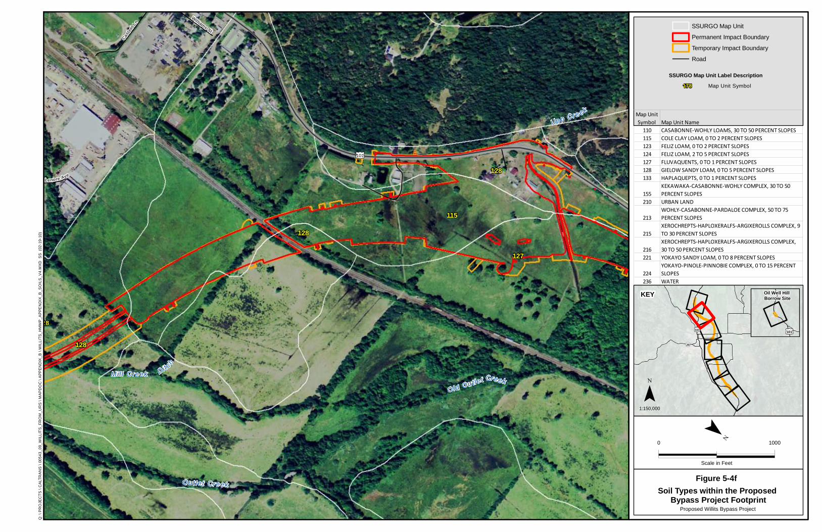
128
Lenore Ave
Williams St
Casteel
Ln
£¤101
Dit c h
Old Ou t le t Creek
Out let Creek
Upp Cr e ek
Mi l l C reek
127
128
128
115
128
Q: \
PR
OJE
CTS
\ C
ALT
RA
NS
\ 00
543_
09_W
ILLI
TS
_FR
OM
_UR
S \
MA
PD
OC
\ A
PP
EN
DIX
_B \
WIL
LITS
_HM
MP
_AP
PE
ND
IX_B
_SO
ILS
_V4.
MX
D S
S (
02-1
9-10
)
0 1000
Scale in Feet
¯
Proposed Willits Bypass Project
FigureSoil Types within the Proposed
Bypass Project Footprint
SSURGO Map Unit
Permanent Impact Boundary
Temporary Impact Boundary
Road
Map Unit Symbol Map Unit Name
110 CASABONNE-WOHLY LOAMS, 30 TO 50 PERCENT SLOPES115 COLE CLAY LOAM, 0 TO 2 PERCENT SLOPES123 FELIZ LOAM, 0 TO 2 PERCENT SLOPES124 FELIZ LOAM, 2 TO 5 PERCENT SLOPES127 FLUVAQUENTS, 0 TO 1 PERCENT SLOPES128 GIELOW SANDY LOAM, 0 TO 5 PERCENT SLOPES133 HAPLAQUEPTS, 0 TO 1 PERCENT SLOPES
155KEKAWAKA-CASABONNE-WOHLY COMPLEX, 30 TO 50 PERCENT SLOPES
210 URBAN LAND
213WOHLY-CASABONNE-PARDALOE COMPLEX, 50 TO 75 PERCENT SLOPES
215XEROCHREPTS-HAPLOXERALFS-ARGIXEROLLS COMPLEX, 9 TO 30 PERCENT SLOPES
216XEROCHREPTS-HAPLOXERALFS-ARGIXEROLLS COMPLEX, 30 TO 50 PERCENT SLOPES
221 YOKAYO SANDY LOAM, 0 TO 8 PERCENT SLOPES
224YOKAYO-PINOLE-PINNOBIE COMPLEX, 0 TO 15 PERCENT SLOPES
236 WATER
£¤101
¬«20
£¤101
Oil Well Hill Borrow Site
1:150,000
¯
KEY
5-4f
SSURGO Map Unit Label Description178 Map Unit Symbol

£¤101
Out let Creek
Mi l l C reek
Old Ou tle t C reek
Upp Creek
127
215
133
128
115
Q: \
PR
OJE
CTS
\ C
ALT
RA
NS
\ 00
543_
09_W
ILLI
TS
_FR
OM
_UR
S \
MA
PD
OC
\ A
PP
EN
DIX
_B \
WIL
LITS
_HM
MP
_AP
PE
ND
IX_B
_SO
ILS
_V4.
MX
D S
S (
02-1
9-10
)
0 1000
Scale in Feet
¯
Proposed Willits Bypass Project
FigureSoil Types within the Proposed
Bypass Project Footprint
SSURGO Map Unit
Permanent Impact Boundary
Temporary Impact Boundary
Road
Map Unit Symbol Map Unit Name
110 CASABONNE-WOHLY LOAMS, 30 TO 50 PERCENT SLOPES115 COLE CLAY LOAM, 0 TO 2 PERCENT SLOPES123 FELIZ LOAM, 0 TO 2 PERCENT SLOPES124 FELIZ LOAM, 2 TO 5 PERCENT SLOPES127 FLUVAQUENTS, 0 TO 1 PERCENT SLOPES128 GIELOW SANDY LOAM, 0 TO 5 PERCENT SLOPES133 HAPLAQUEPTS, 0 TO 1 PERCENT SLOPES
155KEKAWAKA-CASABONNE-WOHLY COMPLEX, 30 TO 50 PERCENT SLOPES
210 URBAN LAND
213WOHLY-CASABONNE-PARDALOE COMPLEX, 50 TO 75 PERCENT SLOPES
215XEROCHREPTS-HAPLOXERALFS-ARGIXEROLLS COMPLEX, 9 TO 30 PERCENT SLOPES
216XEROCHREPTS-HAPLOXERALFS-ARGIXEROLLS COMPLEX, 30 TO 50 PERCENT SLOPES
221 YOKAYO SANDY LOAM, 0 TO 8 PERCENT SLOPES
224YOKAYO-PINOLE-PINNOBIE COMPLEX, 0 TO 15 PERCENT SLOPES
236 WATER
£¤101
¬«20
£¤101
Oil Well Hill Borrow Site
1:150,000
¯
KEY
5-4g
SSURGO Map Unit Label Description178 Map Unit Symbol

Scho
w Rd
Ryan Creek Rd
£¤101
Out le t Cree k
110
213155
Q: \
PR
OJE
CTS
\ C
ALT
RA
NS
\ 00
543_
09_W
ILLI
TS
_FR
OM
_UR
S \
MA
PD
OC
\ A
PP
EN
DIX
_B \
WIL
LITS
_HM
MP
_AP
PE
ND
IX_B
_SO
ILS
_V4.
MX
D S
S (
02-1
9-10
)
0 1000
Scale in Feet
¯
Proposed Willits Bypass Project
FigureSoil Types within the Proposed
Bypass Project Footprint
SSURGO Map Unit
Permanent Impact Boundary
Temporary Impact Boundary
Road
Map Unit Symbol Map Unit Name
110 CASABONNE-WOHLY LOAMS, 30 TO 50 PERCENT SLOPES115 COLE CLAY LOAM, 0 TO 2 PERCENT SLOPES123 FELIZ LOAM, 0 TO 2 PERCENT SLOPES124 FELIZ LOAM, 2 TO 5 PERCENT SLOPES127 FLUVAQUENTS, 0 TO 1 PERCENT SLOPES128 GIELOW SANDY LOAM, 0 TO 5 PERCENT SLOPES133 HAPLAQUEPTS, 0 TO 1 PERCENT SLOPES
155KEKAWAKA-CASABONNE-WOHLY COMPLEX, 30 TO 50 PERCENT SLOPES
210 URBAN LAND
213WOHLY-CASABONNE-PARDALOE COMPLEX, 50 TO 75 PERCENT SLOPES
215XEROCHREPTS-HAPLOXERALFS-ARGIXEROLLS COMPLEX, 9 TO 30 PERCENT SLOPES
216XEROCHREPTS-HAPLOXERALFS-ARGIXEROLLS COMPLEX, 30 TO 50 PERCENT SLOPES
221 YOKAYO SANDY LOAM, 0 TO 8 PERCENT SLOPES
224YOKAYO-PINOLE-PINNOBIE COMPLEX, 0 TO 15 PERCENT SLOPES
236 WATER
£¤101
¬«20
£¤101
Oil Well Hill Borrow Site
1:150,000
¯
KEY
5-4h
SSURGO Map Unit Label Description178 Map Unit Symbol
Chapter 5. Baseline Information
Mitigation and Monitoring Proposal Willits Bypass Project
January 2012 5-15
Soils drain better and are less likely to be hydric along the southern third of the bypass alignment footprint (from the Haehl Creek interchange to East Hill Road). Soils are also well-drained and not likely to be hydric in the Oil Well Hill area. Soils along the remaining portion of the alignment footprint (north of East Hill Road) are less well-drained (ranging from somewhat poorly drained to very poorly drained) and are more likely to have areas that meet hydric conditions. North Coast semaphore grass and Baker’s meadowfoam were found in these northern areas and were associated primarily with the Cole Clay Loam, 0–2% slopes map unit and the Fluvaquents, 0–1% slopes map unit. Sections 5.2.3.1 through 5.2.3.14 provide brief descriptions of the map units that intersect the bypass alignment footprint boundaries.
Caltrans performed soil surveys in 2010 and 2011 in support of Group 1 and Group 2 wetland establishment sites, respectively. The soil surveys indicate that the soil characteristics at the Group 1 and 2 establishment sites would support wetland establishment. Appendix J includes memoranda summarizing the results of these soil surveys.
5.2.3.1 Casabonne-Wohly Loams, 30–50% Slopes
This map unit is on hills and mountains. The native vegetation is mainly Douglas-fir, tanoak, and Pacific madrone. Included in this unit are small areas of Bearwallow, Hellman, Hopland, Pardaloe, and Woodin soils. Included areas make up approximately 20% of the map unit.
The Casabonne soil is deep and well-drained, and formed in material weathered from sandstone or shale. Typically, the surface layer is loam approximately 15 inches thick. Permeability of the Casabonne soil is moderate. Available water capacity is high. Effective rooting depth is 40–60 inches, and runoff is rapid.
The Wohly soil is moderately deep and well-drained, and formed in material weathered from sandstone or shale. Typically, the surface layer is loam approximately 11 inches thick. Permeability of the Wohly soil is moderate. Available water capacity is low to moderate. Effective rooting depth is 20–40 inches, and runoff is rapid.
Among the common forest understory plants are brackenfern, blue wildrye, rose, perennial bromes, and fescues. However, the soils in this unit retain their tendency to produce woody species. Grass is difficult to maintain in most areas.
5.2.3.2 Cole Clay Loam, 0–2% Slopes
This very deep, somewhat poorly drained soil is on alluvial plains and in basins, and formed in recent alluvium derived primarily from sedimentary rock. The vegetation in uncultivated areas is mainly annual grasses and forbs. Included in this unit are small areas of Clear Lake soils and Cole soils that are poorly drained and have a water table at a depth of less than 18 inches. Included areas make up approximately 5% of the map unit.
Typically, the surface layer is clay loam approximately 8 inches thick. Permeability of this Cole soil is slow. Available water capacity is high. Effective rooting depth is 60 inches or more. Runoff is ponded, and there is a high water table year round at a depth of 18–36 inches.
Chapter 5. Baseline Information
Mitigation and Monitoring Proposal Willits Bypass Project
January 2012 5-16
5.2.3.3 Feliz Loam, 0–2% Slopes
This very deep, well-drained soil is on alluvial plains and fans, and formed in alluvium derived primarily from sedimentary rock. The vegetation in areas not cultivated is mainly annual grasses and scattered oaks. Included in this unit are areas of Russian loam. Also included are small areas of Cole, Pinnobie, Pinole, and Talmage soils and Xerofluvents. Included areas make up approximately 15% of the map unit.
Typically, the surface layer is loam over clay loam approximately 26 inches thick. Permeability of this Feliz soil is moderate. Available water capacity is very high. Effective rooting depth is 60 inches or more, and runoff is slow.
5.2.3.4 Feliz Loam, 2–5% Slopes
This very deep, well-drained soil is on alluvial plains and fans, and formed in alluvium derived primarily from sedimentary rock. The vegetation in areas not cultivated is mainly annual grasses and scattered oaks. Included in this unit are areas of Russian loam. Also included are small areas of Cole, Pinnobie, Pinole, and Talmage soils and Xerofluvents. Included areas make up approximately 15% of the map unit.
Typically, the surface layer is loam over clay loam approximately 26 inches thick. Permeability of this Feliz soil is moderate. Available water capacity is very high. Effective rooting depth is 60 inches or more, and runoff is slow.
5.2.3.5 Fluvaquents, 0–1% Slopes
These very deep, poorly drained and very poorly drained soils are on floodplains, and formed in recent alluvium derived primarily from sedimentary rock. The native vegetation is mainly annual and perennial grasses and forbs. Included in this unit are small areas of Cole and Gielow soils, and small areas of Haplaquepts in basins toward the northern end of Little Lake Valley. Included areas make up approximately 15% of the map unit.
No single profile of Fluvaquents is typical, but one commonly observed in the survey area has a mottled, sandy loam surface layer approximately 2 inches thick. Permeability of these Fluvaquents is moderately slow to moderately rapid. Available water capacity is generally high but is lower in areas where sandy material makes up more than half of the upper 60 inches. Runoff is very slow to ponded, and a seasonal (November to March) high water table fluctuates between the surface and a depth of 18 inches.
5.2.3.6 Gielow Sandy Loam, 0–5% Slopes
This very deep, somewhat poorly drained soil is on alluvial plains and fans. This soil formed in alluvium derived primarily from sedimentary rock. The vegetation in areas not cultivated is mainly annual and perennial grassland and oaks. Included in this unit are small areas of Clear Lake, Cole, Feliz, Russian, and Talmage soils. In Little Lake and Pound valleys, soils that have narrow bands of gravel make up 1–5% of the unit. Included areas make up approximately 10% of the map unit.
Chapter 5. Baseline Information
Mitigation and Monitoring Proposal Willits Bypass Project
January 2012 5-17
Typically, the surface layer is stratified, sandy loam, and loam approximately 18 inches thick. Permeability of this Gielow soil is moderate. Available water capacity is high. Effective rooting depth is 60 inches or more. Runoff is very slow to slow and a seasonal (November to March) high water table fluctuates between depths of 18 and 36 inches.
5.2.3.7 Haplaquepts, 0–1% Slopes
These very deep, poorly drained soils are in basins and on floodplains. These soils formed in alluvium derived primarily from sedimentary rock. The native vegetation is mainly aquatic herbs, sedges, and annual grasses. Included in this unit are small areas of Cole clay loam bordering basin areas. Also included are small areas of Gielow sandy loam adjacent to drainageways, and Fluvaquents along old creek bottoms and drainageways. Included areas make up approximately 10% of the map unit.
No single profile of Haplaquepts is typical, but one commonly observed in the survey area has a clay loam surface layer approximately 3 inches thick. Permeability of these Haplaquepts soils is slow to moderately slow. Available water capacity is high to very high. Effective rooting depth is 60 inches or more. Runoff is ponded, and a seasonal (December to April) high water table is 12 inches above the surface to 12 inches below the surface.
5.2.3.8 Kekawaka-Casabonne-Wohly Complex, 30–50% Slopes
This map unit is on side slopes of hills and mountains. The native vegetation is mainly coniferous forest. Among the common forest understory plants are brackenfern, blue wildrye, rose, and perennial bromes and fescues. This unit is 35% Kekawaka loam, 20% Casabonne gravelly loam, and 20% Wohly loam. The components of this unit are so intricately intermingled that it was not practical to map them separately at the scale used. Included in this unit are small areas of Cummiskey, Sanhedrin, Pardaloe, and Woodin soils, rock outcrop, and soils similar to the Casabonne and Kekawaka soils. Included areas make up approximately 25% of the map unit.
The Kekawaka soil is very deep and well-drained, and formed in material derived primarily from sandstone and siltstone. The surface layer is loam approximately 4 inches thick. Permeability of the Kekawaka soil is moderately slow. Available water capacity is high, effective rooting depth is 60 inches or more, and runoff is rapid.
The Casabonne soil is deep and well-drained. It formed in material derived predominantly from sandstone and shale. Typically, the surface layer is gravelly loam approximately 15 inches thick. Permeability of the Casabonne soil is moderate. Available water capacity is moderate to high. Effective rooting depth is 40–60 inches, and runoff is rapid.
The Wohly soil is moderately deep and well-drained, and formed in material weathered from sandstone and shale. Typically, the surface layer is loam approximately 11 inches thick. Permeability of the Wohly soil is moderate. Available water capacity is low to moderate. Effective rooting depth is 20–40 inches, and runoff is rapid.

Chapter 5. Baseline Information
Mitigation and Monitoring Proposal Willits Bypass Project
January 2012 5-18
5.2.3.9 Urban Land
This map unit is on terraces and alluvial plains in Ukiah and Little Lake Valleys. Approximately 60% of this unit consists of areas covered by concrete, asphalt, buildings, or other impervious surfaces, and approximately 30% consists of open areas that have been altered by cutting and filling or grading for housing developments, shopping centers, schools, parks, industrialized areas, and other similar uses.
Included in this unit are small areas of Talmage soils and Xerofluvents near creekbeds and Cole, Feliz, Pinole, Pinnobie, and Yokayo soils in relatively undisturbed areas. Included areas make up approximately 10% of the map unit. Drainage, permeability, surface runoff, and available water capacity are all variable.
5.2.3.10 Wohly-Casabonne-Pardaloe Complex, 50–75% Slopes
This map unit is on hills and mountains. The native vegetation is mainly Douglas-fir, tanoak, Pacific madrone, and California black oak. Among the common forest understory plants are brackenfern, blue wildrye, rose, and perennial grasses. This unit is 45% Wohly loam, 20% Casabonne gravelly loam, and 15% Pardaloe gravelly loam. The components of this unit are so intricately intermingled that it was not practical to map them separately at the scale used. Included in this unit are small areas of Bearwallow, Kekawaka, Squawrock, and Yorkville soils. This map unit makes up approximately 20% of the total impact area.
The Wohly soil is moderately deep and well-drained, and formed in material weathered from sandstone and shale. Typically, the surface layer is loam approximately 11 inches thick. Permeability of the Wohly soil is moderate. Available water capacity is low to moderate. Effective rooting depth is 20–40 inches, and runoff is rapid.
The Casabonne soil is deep and well-drained, and formed in material derived predominantly from sandstone and shale. Typically, the surface layer is gravelly loam approximately 15 inches thick. Permeability of the Casabonne soil is moderate. Available water capacity is moderate to high. Effective rooting depth is 40–60 inches, and runoff is rapid.
The Pardaloe soil is deep and well-drained, and formed in material weathered from sandstone, siltstone, or shale. The surface layer is gravelly loam approximately 10 inches thick. Permeability of the Pardaloe soil is moderate. Available water capacity is low. Effective rooting depth is 40–60 inches, and runoff is very rapid.
5.2.3.11 Xerochrepts-Haploxeralfs-Argixerolls Complex, 9–30% Slopes
This map unit is on dissected stream terraces and terrace escarpments. The native vegetation is mainly scattered oaks, ponderosa pine, Douglas-fir, and manzanita. Among the common forest understory plants are manzanita, reed fescue, poison-oak, and bedstraw. This unit is 35% Xerochrepts, 30% Haploxeralfs, and 25% Argixerolls. The components of this unit are so intricately intermingled that it was not practical to map them separately at the scale used. Included in this unit are small areas of Redvine soils on ridgetops; Feliz, Gielow, and Talmage
Chapter 5. Baseline Information
Mitigation and Monitoring Proposal Willits Bypass Project
January 2012 5-19
soils along streams; Yorkville soils on hills are underlain by sedimentary rock; and eroded soils. Included areas make up approximately 10% of the map unit.
The Xerochrepts are very deep and well-drained. They formed in alluvium derived from various kinds of rock. No single profile of these soils is typical, but one commonly observed in the survey area has a surface layer of loam approximately 12 inches thick. Permeability of the Xerochrepts is moderate. Effective rooting depth is 60 inches or more, and runoff is rapid.
The Haploxeralfs are very deep and well-drained. They formed in alluvium derived from various kinds of rock. No single profile of these soils is typical, but one commonly observed in the survey area has a surface layer of sandy loam or loam 9 inches thick. Permeability of the Haploxeralfs is moderate to moderately rapid. Available water capacity is moderate. Effective rooting depth is 60 inches or more, and runoff is medium to rapid.
The Argixerolls are very deep and are moderately well-drained to well-drained. They formed in alluvium derived from various kinds of rock. No single profile of these soils is typical, but one commonly observed in the survey area has a surface layer of gravelly loam or loam 11 inches thick. Permeability of the Argixerolls is slow to moderately rapid. Available water capacity is high to very high. Effective rooting depth is 60 inches or more, and runoff is medium to rapid.
5.2.3.12 Xerochrepts-Haploxeralfs-Argixerolls Complex, 30–50% Slopes
This map unit is on dissected stream terraces and terrace escarpments. The native vegetation is mainly scattered oaks, ponderosa pine, Douglas-fir, and manzanita. Among the common forest understory plants are manzanita, red fescue, poison-oak, and bedstraw. This unit is 40% Xerochrepts, 30% Haploxeralfs, and 20% Argixerolls. The components of this unit are so intricately intermingled that it was not practical to map them separately at the scale used. Included in this unit are small areas of Redvine soils on ridgetops, Yorktree soils on hills and underlain by sedimentary rock, and eroded soils. Included areas make up 10% of the map unit.
The Xerochrepts are very deep and well-drained. They formed in alluvium derived from various kinds of rock. No single profile of these soils is typical, but one commonly observed in the survey area has a surface layer of loam approximately 12 inches thick. Permeability of the Xerochrepts is moderate. Effective rooting depth is 60 inches or more, and runoff is rapid.
The Haploxeralfs are very deep and well-drained. They formed in alluvium derived from various kinds of rock. No single profile of these soils is typical, but one commonly observed in the survey area has a surface layer of sandy loam or loam 9 inches thick. Permeability of the Haploxeralfs is moderate to moderately rapid. Available water capacity is moderate. Effective rooting depth is 60 inches or more, and runoff is medium to rapid.
The Argixerolls are very deep and are moderately well-drained to well-drained. They formed in alluvium derived from various kinds of rock. No single profile of these soils is typical, but one commonly observed in the survey area has a surface layer of gravelly loam or loam 11 inches thick. Permeability of the Argixerolls is slow to moderately rapid. Available water capacity is high to very high. Effective rooting depth is 60 inches or more, and runoff is medium to rapid.
Chapter 5. Baseline Information
Mitigation and Monitoring Proposal Willits Bypass Project
January 2012 5-20
5.2.3.13 Yokayo Sandy Loam, 0–8% Slopes
This very deep, well-drained soil is on old dissected terraces, and formed in old alluvium derived primarily from sedimentary rock. Vegetation in areas not cultivated is mainly annual grasses and scattered oaks. Oregon white oak, blue oak, California black oak, and Pacific madrone are the main tree species in areas where this unit has not been cleared. Among the common forest understory plants are manzanita, poison-oak, ripgut brome, and bluestem wildrye. Included in this unit are small areas of Pinnobie, Pinole, and Redvine soils. Included areas make up approximately 15% of the map unit.
Typically, the surface layer is sandy loam approximately 8 inches thick. Permeability of this Yokayo soil is moderately rapid to a depth of 8 inches and very slow below this depth. Available water capacity is moderate. Effective rooting depth is 60 inches or more, and runoff is medium.
5.2.3.14 Yokayo-Pinole-Pinnobie Complex, 0–15% Slopes
This map unit is on old dissected stream terraces. The native vegetation is mainly annual grasses and occasional oaks and chaparral. Common plants are soft chess, wild oat, purple needlegrass, and filaree. This unit is 35% Yokayo sandy loam, 30% Pinole gravelly loam, and 20% Pinnobie loam. The components of this unit are so intricately intermingled that it was not practical to map them separately at the scale used. Included in this unit are small areas of Redvine soils on ridgetops, Feliz and Talmage soils along streams, and Yorktree soils on hills underlain by sedimentary rock. Included areas make up approximately 15% of the map unit.
The Yokayo soil is very deep and well-drained, and formed in old alluvium derived primarily from sedimentary rock. Typically, the surface layer is sandy loam approximately 8 inches thick. Permeability of this Yokayo soil is moderately rapid to a depth of 8 inches and very slow below this depth. Available water capacity is moderate. Effective rooting depth is 60 inches or more, and runoff is medium.
The Pinole soil is very deep and well-drained, and formed in alluvium derived primarily from sedimentary rock. Typically, the surface layer is gravelly loam approximately 10 inches thick. Permeability of the Pinole soil is moderately slow. Available water capacity is moderate. Effective rooting depth is 60 inches or more, and runoff is medium.
The Pinnobie soil is very deep and well-drained. It formed in alluvium derived primarily from sedimentary rock. Typically, the surface layer is loam approximately 11 inches thick. Permeability of the Pinnobie soil is moderate. Available water capacity is high. Effective rooting depth is 60 inches or more, and runoff is medium.
5.2.4 Jurisdictional Wetlands and Other Waters of the United States
The project will affect numerous jurisdictional wetlands and other waters of the United States. These jurisdictional features include wet meadows, riparian scrub, riparian woodland wetlands, vernal pools, swales, marshes, creeks and streams, and drainages (Appendix B).

Chapter 5. Baseline Information
Mitigation and Monitoring Proposal Willits Bypass Project
January 2012 5-21
Wet meadow is the most extensive wetland type in the bypass alignment footprint, found in multiple locations in both natural and artificial settings. Large areas of managed hayland and/or grazed pasture are included as wet meadow. Typically, introduced, nonnative perennial forage grasses dominate wet-meadow agricultural pasture. Wet meadows develop in areas where the soil and hydrology have remained undisturbed (or only minimally disturbed) for many years. Wet meadows typically have poorly drained soils and receive water from winter and spring precipitation, agricultural field and pasture irrigation, creek floodplain aquifers, overbank flooding, and sheet drainage from excessive runoff. Facultative and facultative wet wetland species such as sedges and rushes often compose a significant component of the total hydrophytic vegetation in wet meadows in the bypass alignment footprint. Other dominant species include pasture grasses such as tall fescue, Italian ryegrass, velvet grass, Harding grass, and other wetland species such as Davy’s semaphore grass, creeping bentgrass, meadow foxtail, California oatgrass, creeping ryegrass, pennyroyal, western buttercup, and curly dock. In addition, ash and valley oak trees are found sporadically in some wet meadows.
During wet winters, portions of the wet-meadow areas flood, providing habitat for a number of wildlife species, including cinnamon teal, mallard, American widgeon, northern shoveler, wood duck, and American coot. These wetlands serve as a source of water for Outlet Creek downstream of Little Lake Valley, where it becomes a perennial stream during the summer months, when the stream reaches in the valley are usually dry.
Vernal pools and swales are found throughout the wet meadow communities and in upland grassland habitats south and north of East Hill Road. Swales are shallow, vegetated channels that tend to accumulate surface runoff during wet seasons (California Department of Transportation 2005a). Vernal pools consist of small to large depressions in areas where heavy clay soil horizons occur. They are internally drained basins that collect rainfall and surface runoff from surrounding grasslands. The impervious layer of subsoil prevents water from quickly infiltrating into the soil, forming a shallow, perched water table that is exposed in some depressions. The frequency and duration of ponding and saturation vary among vernal pools depending on the size of the watershed, depth to the impervious subsoil layer, and timing and amounts of rainfall during each rainy season. Characteristic annual hydrophytic plant species in the vernal pools and swales include bracted popcornflower, purslane speedwell, downingia, Bolander’s water-starwort, toad rush, Baker’s meadowfoam, Douglas’ meadowfoam, semaphore grass, and owl’s-clover. Herbaceous perennials include spreading rush, slender beak sedge, greensheath sedge, meadow foxtail, Timothy grass, pennyroyal, and curly dock (California Department of Transportation 2005a).
Marsh is the second most widely affected wetland type, by area. Two marsh communities were identified in the bypass alignment footprint: mixed marsh and tule marsh, as described below. Floodwater from Outlet Creek that is trapped in basins and shallow groundwater are the principal sources of water for marshes in Little Lake Valley.
• Mixed marsh in the bypass alignment footprint is found in internally drained basins and low-lying troughs throughout the northern portion of Little Lake Valley. In the bypass alignment footprint, mixed marsh occurs primarily in the Quail Meadows area. Mixed marsh is characterized by annual and perennial herbs and grass-like species with taller perennials scattered throughout. Dominant species include knotweed, broadleaf water plantain, common

Chapter 5. Baseline Information
Mitigation and Monitoring Proposal Willits Bypass Project
January 2012 5-22
spikerush, reed canary grass, broadleaf cattail, tule, and Nebraska sedge (California Department of Transportation 2000, 2005a).
• Tule marsh is found in the northern portion of Little Lake Valley where it borders wet meadows and riparian woodlands and forms small to large patches within mixed marsh wetlands. Unlike mixed marshes, which support a diversity of plants, tule marshes are dominated by dense monotypic thickets of tule, with minimal cover by other species (California Department of Transportation 2005a).
Most of the marsh is east of US 101 on the Brooke parcel at the northern end of the bypass alignment footprint (Appendix B). A large area of riparian woodland wetland is associated with this marsh area. Smaller areas of marsh are shown in Appendix B.
The project will affect some areas of riparian scrub and riparian woodland wetland. These jurisdictional wetlands are associated with various riparian areas throughout the project vicinity. Riparian scrub is found in scattered locations throughout Little Lake Valley along streams and drainage ditches, as follows.
• Willow riparian scrub is found in scattered locations throughout the bypass alignment footprint. In addition, willow riparian scrub extends throughout the same ranges as valley oak riparian woodland. The main species are arroyo willow, red willow, and Scouler’s willow.
• Mixed riparian scrub usually develops in artificial or highly disturbed habitats along ditches. Mixed scrub vegetation grows 10–30 ft tall and is dominated by coyote bush, poison-oak, California rose, Himalayan blackberry, blue elderberry, and arroyo willow. Wet meadow species form the dominant understory in portions of the mixed scrub community. Mixed riparian scrub in upland areas generally lacks a herbaceous layer and is dominated by coyote bush, poison-oak, and Himalayan blackberry.
Riparian woodlands in the bypass alignment footprint range from multilayered, multispecies woodlands with dense scrub understory to small groups of trees. Riparian woodland communities might have occupied extensive portions of Little Lake Valley before these areas were cleared for pasture and agriculture. In general, riparian communities qualify as sensitive plant communities because they are relatively scarce compared to their historical extent and because they provide important foraging and nesting habitat for many resident and migratory wildlife species (Gaines 1974; Remsen 1978; Harris et al. 1988; Sanders and Flett 1989). Three types of riparian woodland habitat occur in the bypass alignment footprint.
• Mixed riparian woodland, comprising canopy, midstory, shrub, and herb layers, is found along major creeks and drainages throughout the bypass alignment footprint. Box elder, red alder, Oregon ash, Fremont cottonwood, valley oak, and arroyo willow dominate the canopy and midstory layers. Himalayan blackberry, California blackberry, dogwood, twinberry, gooseberry, California rose, blue elderberry, and clematis dominate the shrub layer. Common plants in the herb layer include short-scale sedge, creeping ryegrass, spreading rush, avens, cow parsnip, common dandelion, and common meadow-rue (California Department of Transportation 2000, 2005a).
• Ash riparian woodland is common in the northern and central portions of the bypass alignment footprint, where it is found along creeks, fence rows, levees, troughs, and low
Chapter 5. Baseline Information
Mitigation and Monitoring Proposal Willits Bypass Project
January 2012 5-23
terraces. This community occurs in wetter landscape positions than other riparian habitat types in Little Lake Valley, and the long-term flooding and soil saturation that characterize it can preclude the establishment of other riparian tree species. The overstory consists entirely of Oregon ash. The shrubs and herbaceous species found in the understory vary with the amount of soil moisture. Oregon ash saplings, arroyo willow, and blackberry are commonly observed in the understory; in wetter areas, other dominant species are sedges, rushes, perennial ryegrass, western buttercup, cutleaf geranium, common spikerush, reed canary grass, broadleaf cattail, and tule. In drier areas, blackberry shrubs are interspersed with hawthorn, poison-oak, honeysuckle, Pacific ninebark, and white snowberry (California Department of Transportation 2005a).
• Valley oak riparian woodlands are scattered throughout the bypass alignment footprint, typically along low and high terraces adjacent to creeks and intermittent drainages. Scattered individual valley oaks are common in open fields, while groves of valley oaks grow along creeks, fences, and roads on higher terraces (California Department of Transportation 2005a).
Haehl, Baechtel, Broaddus, Mill, Upp, and Outlet Creeks are the major other waters of the United States affected by the project. All these creeks cross the bypass alignment footprint as they convey water through Little Lake Valley. The project also will affect a number of smaller tributaries and drainages in the bypass alignment footprint.
Except for Upp Creek, most streams that traverse the bypass alignment footprint are shaded by mature riparian vegetation. These streams provide fish habitat and support juvenile and adult salmonids. Instream habitat consists of pools, riffles, and shallow runs and glides. Streambanks are typically steep and channels incised.
All five streams within the bypass alignment footprint and the lower parts of their tributaries provide important habitat for adult and juvenile anadromous salmonids migrating to and from Outlet Creek. These streams are considered EFH for coho and Chinook salmon. Some spawning and seasonal rearing could occur in some reaches of these creeks in the bypass alignment footprint (California Department of Transportation 1997; Harris pers. comm.). California roach and introduced warmwater species (e.g., sunfish, largemouth bass) are predominant during reduced-flow periods in summer and early fall. There is a need to improve water quality and general stream habitat conditions at several locations.
Haehl Creek is a 5.1-mile intermittent stream draining a watershed of approximately 6.2 mi2. The watershed is privately owned and primarily managed for urban residential and commercial development (California Department of Fish and Game 1995). In spring 2004, nine reaches of Haehl Creek in the project area were surveyed for Modified Alternative J1T (California Department of Fish and Game 2004). These surveys found existing aquatic habitat for salmonid fish to be extremely poor in three of the reaches and fair in six. Flows ranged from subsurface/intermittent to less than 1 cubic foot per second (cfs). The poorer reaches almost entirely comprised silt-laden runs and pools. The fair reaches had a mix of fines and gravel across pools, runs, and riffles.
Baechtel Creek is a 3.24-mile blue-line stream draining a watershed of approximately 9.17 square miles. Oak grassland dominates the watershed. The watershed is mostly in private

Chapter 5. Baseline Information
Mitigation and Monitoring Proposal Willits Bypass Project
January 2012 5-24
ownership; approximately one third of the watershed lies within the Willits city limits (California Department of Fish and Game 1995). The Humboldt County Resource Conservation District conducted an aquatic invertebrate study on Baechtel Creek in 1998 and found the creek to have moderate to high degradation because of increased sediment loads caused by mass wasting, slumps, and highly erosive soils (Humboldt County Resource Conservation District 1998). In spring 2004, two reaches of Baechtel Creek in the project area were surveyed for Modified Alternative J1T (California Department of Fish and Game 2004). These surveys found existing aquatic habitat for salmonid fish to be fair. Flows were at approximately 3 cfs, and substrates were found to consist of silt/sand/gravel in runs and gravel in riffles.
Broaddus Creek is a 6.27-mile blue-line stream draining a watershed of approximately 7.95 square miles. The watershed is privately owned and is managed as rangeland. One fifth of the watershed is within the Willits city limits. Broaddus Creek has a moderate gradient (2–4%) with entrenched “gully” streambanks for its first 7,037 ft. The Humboldt County Resource Conservation District conducted an aquatic invertebrate study on Broaddus Creek in 1998 and found the creek to have moderate to high degradation because of increased sediment loads caused by mass wasting, slumps, and highly erosive soils (Humboldt County Resource Conservation District 1998). In spring 2004, two reaches of Broaddus Creek in the project area were surveyed for Modified Alternative J1T (California Department of Fish and Game 2004). These surveys found existing aquatic habitat for salmonid fish to be fair. Flows were at approximately 2 cfs, and substrates were found to consist of fines in pools, fines/gravel/boulders in runs, and gravel in riffles.
Upp Creek is an intermittent stream. In spring 2004, two reaches of Upp Creek in the project area were surveyed for Modified Alternative J1T (California Department of Fish and Game 2004). These surveys found existing aquatic habitat for salmonid fish to be extremely poor. Flows were subsurface/intermittent, and substrates were found to consist of fines in pools, fines covering gravel in runs, and gravel in riffles.
Mill Creek is an intermittent stream. In spring 2004, two reaches of Mill Creek in the project area were surveyed for Modified Alternative J1T (California Department of Fish and Game 2004). These surveys found existing aquatic habitat for salmonid fish to be fair.
5.2.5 Protected Fisheries
The project will affect Outlet Creek, five tributary creeks to Outlet Creek (Haehl, Baechtel, Broaddus, Mill, and Upp Creeks), and the streams’ riparian corridors. These streams are designated critical habitat for SONCC coho salmon, California coastal Chinook salmon, and northern California steelhead, and are referred to as protected fisheries in this MMP. The bypass alignment footprint crosses Haehl Creek and its riparian corridor at three locations. One is near the footprint’s southern end where the creek flows west across the alignment area (Appendix B). In this area, the bypass alignment footprint has been minimized to reduce the impact, although the project includes both the exit and entry ramps to the roadway in addition to the main roadway. Haehl Creek then flows north, crossing the footprint twice more near the central portion before it merges with Baechtel Creek, which is located west of the bypass alignment footprint.

Chapter 5. Baseline Information
Mitigation and Monitoring Proposal Willits Bypass Project
January 2012 5-25
Downstream of the confluence with Haehl Creek, Baechtel Creek flows outside the bypass alignment footprint until its confluence with Broaddus Creek. At this confluence, the two streams form Outlet Creek. This intersection is just east of the north corner of the WWTP (Appendix B). North of the confluence of Baechtel and Broaddus Creeks, the bypass alignment footprint crosses Mill and Upp Creeks (Appendix B).
5.2.6 Riparian Habitats
Areas of nonprotected fisheries riparian habitat are found along Haehl Creek in the southern half of the bypass alignment footprint and in the northern half of the bypass alignment footprint north of East Hill Road, along the northern edge of the Rutledge stock pond, along an area east and west of the railroad corridor, lining a tributary of Mill Creek, and on the Brooke parcel (Appendix B).
5.2.7 State-Listed Plants
The project will affect two state-listed plants: North Coast semaphore grass and Baker’s meadowfoam.
The North Coast semaphore grass populations in the bypass alignment footprint occur in the northern portion of the Huffman parcel just east of the bypass alignment intersection with the railroad corridor along a small swale lined with Oregon ash and valley oak trees.
Most Baker’s meadowfoam habitat (observed populations) in the bypass alignment footprint is on the Rutledge parcels and the Niesen and Lusher parcels between the railroad tracks and US 101 extending into the meadows surrounding Upp Creek. There is also a large area of potential Baker’s meadowfoam habitat on the Benbow parcels.
North Coast semaphore grass populations in Little Lake Valley most commonly are associated with forest and woodland edges and other partially to fully shaded mesic sites. The largest and highest-density populations of this species occur east of the bypass alignment footprint. However, there is a population in wet meadow and along the fringe of riparian woodland within the bypass alignment footprint on the Huffman parcel (Appendix B). Field surveys in 2007, 2008, 2009, and 2010 located occurrences of North Coast semaphore grass both within the bypass alignment footprint and on the offsite mitigation properties.
Baker’s meadowfoam populations in Little Lake Valley occur primarily in the wetter northern end of the valley. The largest and highest-density populations of this species occur east of the bypass alignment footprint. The Lusher populations occur at the edge of these larger and more central populations.
In an effort to better identify the extent of potential Baker’s meadowfoam habitat in the bypass alignment footprint, a 1993 study (Balance Hydrologics 1993), which defined the environmental conditions (soil types, hydrology, elevation, and geomorphology) associated with the occurrence of Baker’s meadowfoam, was undertaken. The occurrence of these environmental conditions
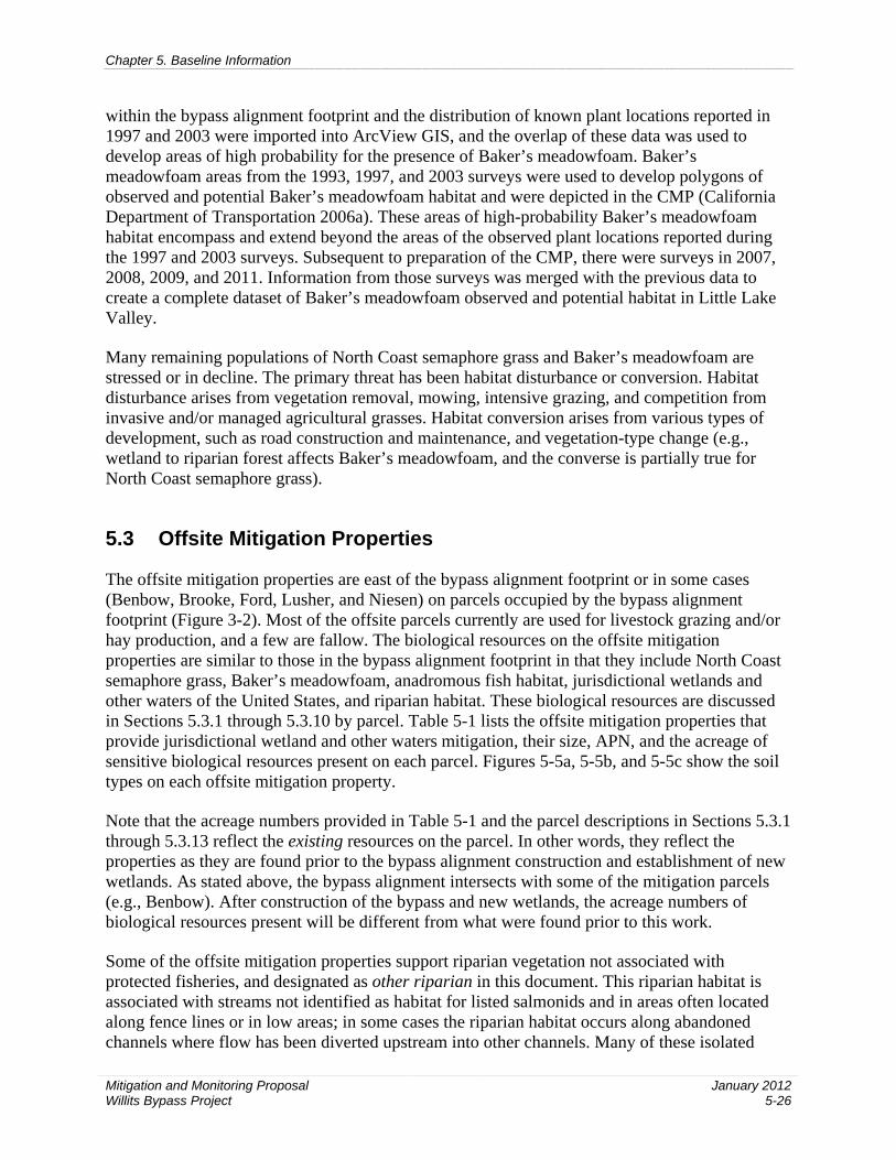
Chapter 5. Baseline Information
Mitigation and Monitoring Proposal Willits Bypass Project
January 2012 5-26
within the bypass alignment footprint and the distribution of known plant locations reported in 1997 and 2003 were imported into ArcView GIS, and the overlap of these data was used to develop areas of high probability for the presence of Baker’s meadowfoam. Baker’s meadowfoam areas from the 1993, 1997, and 2003 surveys were used to develop polygons of observed and potential Baker’s meadowfoam habitat and were depicted in the CMP (California Department of Transportation 2006a). These areas of high-probability Baker’s meadowfoam habitat encompass and extend beyond the areas of the observed plant locations reported during the 1997 and 2003 surveys. Subsequent to preparation of the CMP, there were surveys in 2007, 2008, 2009, and 2011. Information from those surveys was merged with the previous data to create a complete dataset of Baker’s meadowfoam observed and potential habitat in Little Lake Valley.
Many remaining populations of North Coast semaphore grass and Baker’s meadowfoam are stressed or in decline. The primary threat has been habitat disturbance or conversion. Habitat disturbance arises from vegetation removal, mowing, intensive grazing, and competition from invasive and/or managed agricultural grasses. Habitat conversion arises from various types of development, such as road construction and maintenance, and vegetation-type change (e.g., wetland to riparian forest affects Baker’s meadowfoam, and the converse is partially true for North Coast semaphore grass).
5.3 Offsite Mitigation Properties
The offsite mitigation properties are east of the bypass alignment footprint or in some cases (Benbow, Brooke, Ford, Lusher, and Niesen) on parcels occupied by the bypass alignment footprint (Figure 3-2). Most of the offsite parcels currently are used for livestock grazing and/or hay production, and a few are fallow. The biological resources on the offsite mitigation properties are similar to those in the bypass alignment footprint in that they include North Coast semaphore grass, Baker’s meadowfoam, anadromous fish habitat, jurisdictional wetlands and other waters of the United States, and riparian habitat. These biological resources are discussed in Sections 5.3.1 through 5.3.10 by parcel. Table 5-1 lists the offsite mitigation properties that provide jurisdictional wetland and other waters mitigation, their size, APN, and the acreage of sensitive biological resources present on each parcel. Figures 5-5a, 5-5b, and 5-5c show the soil types on each offsite mitigation property.
Note that the acreage numbers provided in Table 5-1 and the parcel descriptions in Sections 5.3.1 through 5.3.13 reflect the existing resources on the parcel. In other words, they reflect the properties as they are found prior to the bypass alignment construction and establishment of new wetlands. As stated above, the bypass alignment intersects with some of the mitigation parcels (e.g., Benbow). After construction of the bypass and new wetlands, the acreage numbers of biological resources present will be different from what were found prior to this work.
Some of the offsite mitigation properties support riparian vegetation not associated with protected fisheries, and designated as other riparian in this document. This riparian habitat is associated with streams not identified as habitat for listed salmonids and in areas often located along fence lines or in low areas; in some cases the riparian habitat occurs along abandoned channels where flow has been diverted upstream into other channels. Many of these isolated

Schow Rd
String
Creek Rd
Reynolds Hwy
£¤101
£¤101
HUFF037-240-RW
WATSON037-250-05
WATSON037-221-30
TAYLOR037-210-14
TAYLOR037-230-16 TAYLOR
037-221-65
TAYLOR037-210-16
172
194
111
137
233
211
123
127
115
124
112
110 127
178
133
126
K:\P
roje
cts_
1\C
altra
ns\0
0543
_09_
Willi
ts_f
rom
_UR
S\m
apdo
c\A
ppen
dix_
C\W
illits
_HM
MP
_App
endi
x_C
_Soi
ls_v
7_93
1.m
xd D
S (
07-0
8-11
)
0 1000
Scale in Feet
¯
Figure 5-5aSoil Types within the
Offsite Mitigation Parcels
Offsite Mitigation Parcels
SSURGO Map Unit
Road
Permanent Impact Boundary
Temporary Impact Boundary
SSURGO Map Unit Label Description
Study Area Label Description178 Map Unit Symbol
Frost108-07-04
Property OwnerAssesor Parcel Number
Proposed Willits Bypass Project
Code Soil Type110 CASABONNE-WOHLY LOAMS, 30 TO 50 PERCENT SLOPES111 CASABONNE-WOHLY-PARDALOE COMPLEX, 50 TO 75
PERCENT SLOPES112 CLEAR LAKE CLAY, 0 TO 2 PERCENT SLOPES115 COLE CLAY LOAM, 0 TO 2 PERCENT SLOPES123 FELIZ LOAM, 0 TO 2 PERCENT SLOPES124 FELIZ LOAM, 2 TO 5 PERCENT SLOPES126 FELIZ CLAY LOAM, GRAVELLY SUBSTRATUM, 2 TO 8
PERCENT SLOPES127 FLUVAQUENTS, 0 TO 1 PERCENT SLOPES128 GIELOW SANDY LOAM, 0 TO 5 PERCENT SLOPES133 HAPLAQUEPTS, 0 TO 1 PERCENT SLOPES137 HENNEKE-MONTARA COMPLEX, 50 TO 75 PERCENT 172 PARDALOE-KEKAWAKA-CASABONNE COMPLEX, 50 TO
75 PERCENT SLOPES178 PINOLE GRAVELLY LOAM, 2 TO 8 PERCENT SLOPES194 SANHEDRIN-KEKAWAKA-SPEAKER COMPLEX, 30 TO 50
PERCENT SLOPES203 TALMAGE GRAVELLY SANDY LOAM, 0 TO 2 PERCENT 211 WITHERELL-HOPLAND-SQUAWROCK COMPLEX, 50 TO 75
PERCENT SLOPES215 XEROCHREPTS-HAPLOXERALFS-ARGIXEROLLS COMPLEX,
9 TO 30 PERCENT SLOPES224 YOKAYO-PINOLE-PINNOBIE COMPLEX, 0 TO 15 PERCENT
SLOPES233 YORKVILLE-SQUAWROCK-WITHERELL COMPLEX, 30 TO
50 PERCENT SLOPES236 WATER
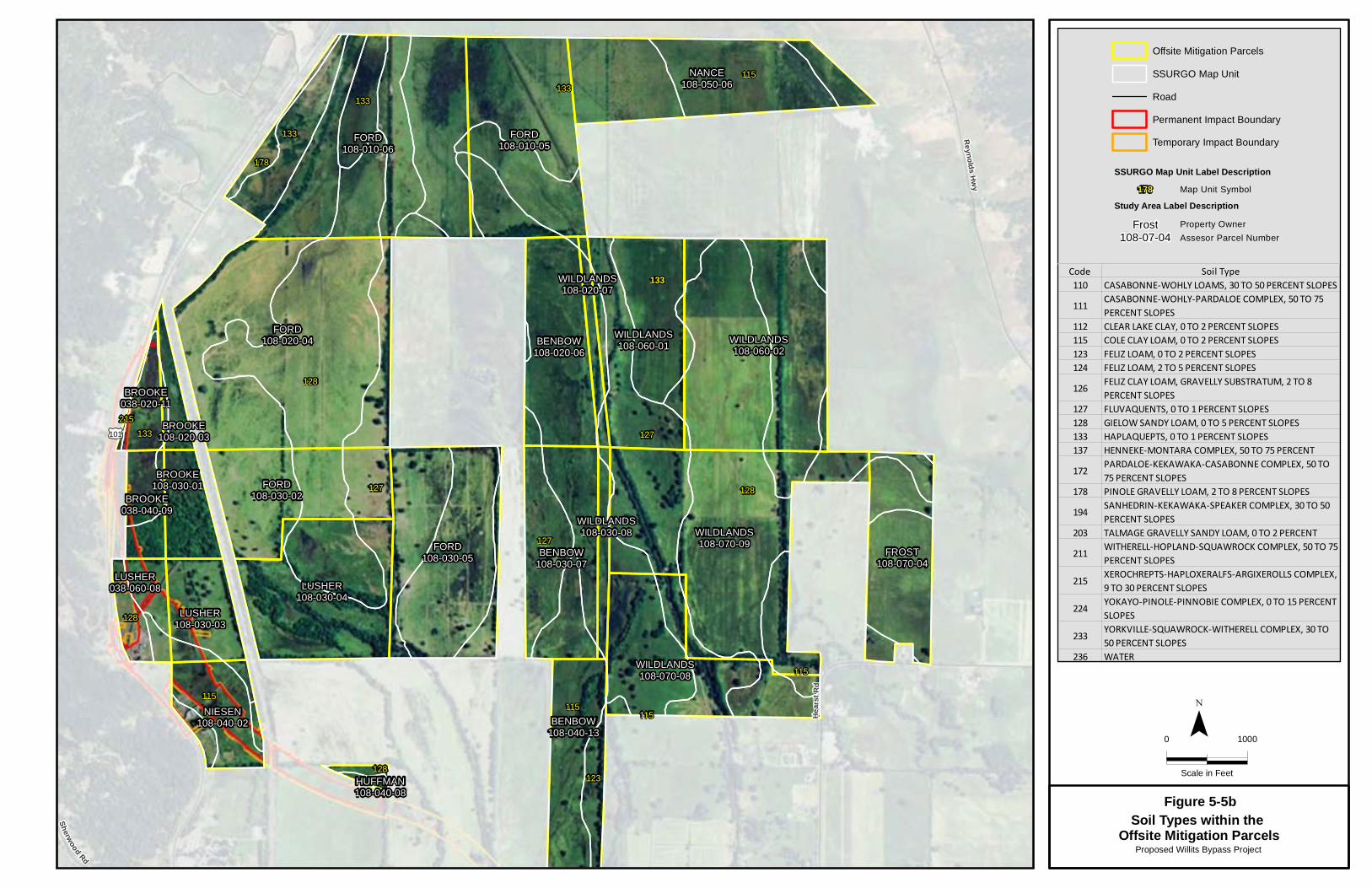
133
Sherwood Rd
Reynolds Hwy
Hea r
st Rd
£¤101
NANCE108-050-06
NIESEN108-040-02
FORD108-010-06
LUSHER108-030-04
FORD108-010-05
BROOKE108-020-03
WILDLANDS108-060-01BENBOW
108-020-06
FORD108-020-04 WILDLANDS
108-060-02
BROOKE038-020-11
LUSHER108-030-03
LUSHER038-060-08
FORD108-030-05 BENBOW
108-030-07
FORD108-030-02
WILDLANDS108-070-09
BROOKE038-040-09
BROOKE108-030-01
FROST108-070-04
WILDLANDS108-070-08
BENBOW108-040-13
WILDLANDS108-020-07
WILDLANDS108-030-08
HUFFMAN108-040-08
133
178
127
115
133
133
127
128
128
215133
127
128
115
115115
128123
115
K:\P
roje
cts_
1\C
altra
ns\0
0543
_09_
Willi
ts_f
rom
_UR
S\m
apdo
c\A
ppen
dix_
C\W
illits
_HM
MP
_App
endi
x_C
_Soi
ls_v
7_93
1.m
xd D
S (
07-0
8-11
)
0 1000
Scale in Feet
¯
Figure 5-5bSoil Types within the
Offsite Mitigation Parcels
Offsite Mitigation Parcels
SSURGO Map Unit
Road
Permanent Impact Boundary
Temporary Impact Boundary
SSURGO Map Unit Label Description
Study Area Label Description178 Map Unit Symbol
Frost108-07-04
Property OwnerAssesor Parcel Number
Proposed Willits Bypass Project
Code Soil Type110 CASABONNE-WOHLY LOAMS, 30 TO 50 PERCENT SLOPES111 CASABONNE-WOHLY-PARDALOE COMPLEX, 50 TO 75
PERCENT SLOPES112 CLEAR LAKE CLAY, 0 TO 2 PERCENT SLOPES115 COLE CLAY LOAM, 0 TO 2 PERCENT SLOPES123 FELIZ LOAM, 0 TO 2 PERCENT SLOPES124 FELIZ LOAM, 2 TO 5 PERCENT SLOPES126 FELIZ CLAY LOAM, GRAVELLY SUBSTRATUM, 2 TO 8
PERCENT SLOPES127 FLUVAQUENTS, 0 TO 1 PERCENT SLOPES128 GIELOW SANDY LOAM, 0 TO 5 PERCENT SLOPES133 HAPLAQUEPTS, 0 TO 1 PERCENT SLOPES137 HENNEKE-MONTARA COMPLEX, 50 TO 75 PERCENT 172 PARDALOE-KEKAWAKA-CASABONNE COMPLEX, 50 TO
75 PERCENT SLOPES178 PINOLE GRAVELLY LOAM, 2 TO 8 PERCENT SLOPES194 SANHEDRIN-KEKAWAKA-SPEAKER COMPLEX, 30 TO 50
PERCENT SLOPES203 TALMAGE GRAVELLY SANDY LOAM, 0 TO 2 PERCENT 211 WITHERELL-HOPLAND-SQUAWROCK COMPLEX, 50 TO 75
PERCENT SLOPES215 XEROCHREPTS-HAPLOXERALFS-ARGIXEROLLS COMPLEX,
9 TO 30 PERCENT SLOPES224 YOKAYO-PINOLE-PINNOBIE COMPLEX, 0 TO 15 PERCENT
SLOPES233 YORKVILLE-SQUAWROCK-WITHERELL COMPLEX, 30 TO
50 PERCENT SLOPES236 WATER

Shell Ln
David
son R
d
Davis
L n
L ive O
ak Rd
Sawy
ers L
n
E asts
ide Rd
B ray
R d
Valley St
Commercial St
Easts
ide Rd
Valley Rd
Hear
st Rd
Center Valley Rd
ARKELIAN103-230-04
MGC PLASMAMIDDLE
103-250-14
BENBOW007-020-03
BENBOW108-040-13
BENBOW007-010-04
GOSS103-230-02
MGC PLASMANORTH
103-230-06
128
127
115
123
236
203
224
115
123
115
112
178
K:\P
roje
cts_
1\C
altra
ns\0
0543
_09_
Willi
ts_f
rom
_UR
S\m
apdo
c\A
ppen
dix_
C\W
illits
_HM
MP
_App
endi
x_C
_Soi
ls_v
7_93
1.m
xd D
S (
07-0
8-11
)
0 1000
Scale in Feet
¯
Figure 5-5cSoil Types within the
Offsite Mitigation Parcels
Offsite Mitigation Parcels
SSURGO Map Unit
Road
Permanent Impact Boundary
Temporary Impact Boundary
SSURGO Map Unit Label Description
Study Area Label Description178 Map Unit Symbol
Frost108-07-04
Property OwnerAssesor Parcel Number
Proposed Willits Bypass Project
Code Soil Type110 CASABONNE-WOHLY LOAMS, 30 TO 50 PERCENT SLOPES111 CASABONNE-WOHLY-PARDALOE COMPLEX, 50 TO 75
PERCENT SLOPES112 CLEAR LAKE CLAY, 0 TO 2 PERCENT SLOPES115 COLE CLAY LOAM, 0 TO 2 PERCENT SLOPES123 FELIZ LOAM, 0 TO 2 PERCENT SLOPES124 FELIZ LOAM, 2 TO 5 PERCENT SLOPES126 FELIZ CLAY LOAM, GRAVELLY SUBSTRATUM, 2 TO 8
PERCENT SLOPES127 FLUVAQUENTS, 0 TO 1 PERCENT SLOPES128 GIELOW SANDY LOAM, 0 TO 5 PERCENT SLOPES133 HAPLAQUEPTS, 0 TO 1 PERCENT SLOPES137 HENNEKE-MONTARA COMPLEX, 50 TO 75 PERCENT 172 PARDALOE-KEKAWAKA-CASABONNE COMPLEX, 50 TO
75 PERCENT SLOPES178 PINOLE GRAVELLY LOAM, 2 TO 8 PERCENT SLOPES194 SANHEDRIN-KEKAWAKA-SPEAKER COMPLEX, 30 TO 50
PERCENT SLOPES203 TALMAGE GRAVELLY SANDY LOAM, 0 TO 2 PERCENT 211 WITHERELL-HOPLAND-SQUAWROCK COMPLEX, 50 TO 75
PERCENT SLOPES215 XEROCHREPTS-HAPLOXERALFS-ARGIXEROLLS COMPLEX,
9 TO 30 PERCENT SLOPES224 YOKAYO-PINOLE-PINNOBIE COMPLEX, 0 TO 15 PERCENT
SLOPES233 YORKVILLE-SQUAWROCK-WITHERELL COMPLEX, 30 TO
50 PERCENT SLOPES236 WATER


Chapter 5. Baseline Information
Mitigation and Monitoring Proposal Willits Bypass Project
January 2012 5-27
areas of riparian habitat appear to have been created during land-clearing for agricultural purposes. In view of the overarching vision of restoring wetland functions and services, protecting other riparian areas that historically were connected to the much more extensive riparian woodlands that occurred in Little Lake Valley is consistent with the mitigation strategy employed on the offsite mitigation properties.
The discussion of baseline conditions below includes information gathered from aerial photographs, topographic maps, soil surveys, and previous studies, which include wetlands delineations and a study by USACE on these parcels in early 2011 The purpose of the evaluations was to characterize soil, vegetation, and hydrology components of the wetlands on the parcels and identify/observe parcel or unit modification(s) that affect wetland components. USACE looked at the three wetland attributes used to define wetlands subject to USACE jurisdiction: hydrophytic vegetation, hydric soils, and wetlands hydrology. The USACE data are included in the following discussion of the baseline conditions on the offsite mitigation properties. Chapter 6 provides a more detailed discussion of the USACE findings, and Appendix I provides the USACE data.
Chapter 5. Baseline Information
Mitigation and Monitoring Proposal Willits Bypass Project
January 2012 5-28
Table 5-1. Summary of Existing Sensitive Biological Resources That Presently Occur on the Offsite Mitigation Properties
Owner APN Size
(acres) NCSG
Observed BM
Observed BM Potential
Habitat Jurisdictional
Wetland
Other Waters of the United
States Riparian Habitat
Benbow
007-010-04 36.16 0.0 0.0 27.78 29.36 0.33 3.75 007-020-03 33.54 0.0 0.0 27.04 27.02 0.23 2.22 108-020-06 46.53 0.0 1.37 43.72 44.91 0.0 2.29 108-030-07 54.74 0.0 1.01 52.76 53.86 0.0 1.89 108-040-13 40.96 0.0 0.01 28.75 36.00 1.16 5.90
Ford
108-010-05 76.57 0.0 13.40 59.68 75.24 1.22 3.56 108-010-06 138.87 0.0 18.14 95.28 113.02 3.38 18.30 108-020-04 143.75 0.0 4.44 132.37 113.54 1.75 11.94 108-030-02 50.99 0.0 0.11 48.38 37.12 0.49 4.32 108-030-05 80.39 0.0 0.08 71.99 60.23 2.15 13.96
Goss 103-230-02 10.08 4.32 0.004 0.0 8.45 0.0 3.19 Lusher 108-030-04 66.17 0.59 0.0 0.0 36.06 2.02 24.97 MGC Plasma North 103-230-06 18.22 0.04 0.10 0.0 4.04 0.0 0.08 MGC Plasma Middle 103-250-14 27.04 0.0 0.0 0.0 2.51 0.0 0.00 Nance 108-050-06 73.90 0.0 27.43 46.47 72.46 0.20 1.42 Niesen 108-040-02 27.43 0.0 2.15 19.04 19.26 0.46 0.14
Watson 037-221-30 115.59 0.0 0.0 95.94 81.14 0.26 16.01 037-250-05 51.11 0.0 0.0 50.15 49.26 0.19 12.15
Wildlands
108-020-07 7.77 0.0 0.04 5.68 2.91 0.16 2.29 108-030-08 8.00 0.0 0.01 5.26 7.03 0.0 1.09 108-060-01 63.39 0.0 0.93 57.14 41.03 1.39 10.66 108-060-02 106.81 0.0 42.38 61.85 101.48 1.19 6.00 108-070-08 64.06 0.0 4.40 47.96 51.14 1.49 16.64 108-070-09 121.87 0.0 3.22 93.26 97.53 2.68 22.07
Total 2098.22 5.10 126.654 1,099.11 1294.27 23.32 231.90 APN = assessor’s parcel number. NCSG = North Coast semaphore grass. BM = Baker’s meadowfoam.
Chapter 5. Baseline Information
Mitigation and Monitoring Proposal Willits Bypass Project
January 2012 5-29
5.3.1 Benbow (APNs 007-010-04, 007-020-03, 108-020-06, 108-030-07, and 108-040-13)
The Benbow property consists of five contiguous parcels totaling approximately 212 acres. The Benbow parcels start just north of East Commercial Street and continue north for approximately 2 miles. The Benbow parcels are used for grazing horses and cattle, and grazing intensity appears to be light. There is no evidence to suggest that the parcels currently are irrigated or that they have been irrigated in the recent past. There was no evidence of cultivation or mowing during field surveys in 2008 and 2009.
A residence, water tower, and barns are on Benbow parcel 007-020-03, just north of East Commercial Street.
5.3.1.1 Historical and Existing Vegetation
The Benbow property likely was vegetated historically in a mosaic of wetland meadow and riparian woodland that extended onto the property from the adjacent drainages. The overstory likely was dominated by a mix of valley oak, Oregon ash, cottonwood, alder, and willow. A 1956 aerial photograph (Cartwright Aerial Surveys 1956) shows a pattern of parallel, north-south lines in the two northernmost parcels (108-020-06 and 108-030-07), suggesting that these parcels were likely in hay production in the past. The photo shows scattered trees and a thin strip of riparian vegetation along the fence rows and channels.
The Benbow parcels currently are managed for grazing and contain mostly perennial grassland and wet-meadow plant communities. The dominant upland grassland species include Kentucky bluegrass, clovers, tall fescue, rough cat’s ear, cranesbill, and perennial ryegrass. Dominant species in the wetlands include meadow foxtail, field sedge, straight beaked buttercup, California semaphore grass, spreading rush, pennyroyal, lythrum, and stipulate popcornflower. Masses of invasive Himalayan blackberry occur in some areas, particularly those that appear to have been disturbed along the western property boundary. Nonnative annual grassland, dominated by Mediterranean barley and perennial ryegrass, occurs in a few very small areas. (California Department of Transportation 2009a; U.S. Army Corps of Engineers 2011)
Riparian woodlands occur along fence rows and the stream channels that border the Benbow parcels. Riparian woodland types include valley oak riparian woodland, mixed riparian woodland, Oregon ash riparian woodland, and willow riparian scrub. Isolated mature valley oaks and Oregon ash occur throughout the Benbow parcels (California Department of Transportation 2009a; U.S. Army Corps of Engineers 2011). These woodlands appear to be much denser than in the 1956 aerial photographs (Cartwright Aerial Surveys 1956).
5.3.1.2 Historical and Existing Hydrology/Topography
Soil survey information from 1920 (Dean 1920) indicates that a lake historically formed at the northern end of Little Lake Valley during the rainy season, even during very low rainfall years. At the end of a series of heavy rainfall events in February 1915, the lake encompassed 1,875

Chapter 5. Baseline Information
Mitigation and Monitoring Proposal Willits Bypass Project
January 2012 5-30
acres and was 12 ft deep over a 300-acre area. At that time, the high water mark of the lake was at the 1,330-ft contour, which roughly corresponds to the north-south midsection of the Benbow parcels.
A 1942 USGS 15-minute series topographic map (included in Wildlands 2008) depicts Baechtel Creek along the western border and an unnamed tributary of Davis Creek along the eastern border of parcels 007-010-04 and 007-020-03. Davis Creek is depicted crossing the northern half of parcel 108-020-06. A 1956 aerial photograph depicts the remnants of this channel in parcel 108-020-06 and shows the realigned Davis Creek channel on the adjoining parcel to the east.
The Benbow parcels currently are drained by numerous swales and channelized intermittent streams tributary to Davis Creek that form the eastern boundary of the parcels. Baechtel Creek forms the boundary of the southwestern side of Benbow parcels 007-010-04 and 007-020-03. Near the northwest corner of parcel 007-010-04, Baechtel and Broaddus Creeks merge and become Outlet Creek. Surface water on the Benbow parcels generally drains toward the northeast along numerous swale systems tributary to Davis Creek. Swales and associated depressions are subject to ponding. These features and low-lying planar areas are subject to a seasonal high water table.
A wetland swale complex on parcel 007-010-04 flows north onto parcel 108-040-13, where it becomes a well-developed unnamed stream channel with riparian vegetation. This channel continues to the northeast and eventually flows into Davis Creek. Another swale complex originates on parcel 108-030-07 and flows northwest onto parcel 108-020-06, eventually forming one swale that continues to the northwest outside this parcel. This swale is bordered on its western bank by a 3-foot-high artificial berm. This swale eventually feeds into an unnamed stream that flows into Outlet Creek.
During fieldwork in May 2010 for the erosion site assessment of the offsite mitigation properties (California Department of Transportation 2010), eight erosion sites were identified on Benbow parcels 108-020-06 (two instream headcuts), 108-040-13 (two instream eroding banks and two upland sites), and 007-020-03 (two instream eroding banks) (Appendix H).
Parcel 108-020-06 was identified as having two instream headcuts that occur on swales near its southwest corner (Figure 3-1 in Appendix H). The areas of and adjacent to each headcut are well-vegetated wet meadow with sandy loam soils (Gielow sandy loam, 0–5% slopes; see Section 5.3.2.3). These headcuts appear relatively stable and are not contributing to downstream sedimentation because both have very small drops (0.5–0.6 foot), and any associated sediment derived from these headcuts is minimal and is spread out and deposited in the existing wetland complex to the north. Water quality monitoring data will be collected for several parameters, including parameters related to sediment levels. If the data show that increased sedimentation is occurring in the vicinity of the offsite mitigation properties, these erosion features will be inspected to determine whether the headcuts are becoming unstable and contributing excessive sediment to the parcel and valley streams (Chapter 11).
Parcel 108-040-13 was identified with two instream eroding bank sites and two upland sites. The instream eroding bank sites occur in association with a large swale and an intermittent stream channel (see Figure 3-1 in Appendix H). Both of these sites have streambanks that range from 2

Chapter 5. Baseline Information
Mitigation and Monitoring Proposal Willits Bypass Project
January 2012 5-31
to 3 ft high and are composed of relatively compact and stable soil. The two upland erosion sites are in the center of the parcel. One of these sites is a large headcut in a swale that is tributary to the aforementioned intermittent stream, and the other is a small pothole adjacent to this swale. The areas adjacent to these sites are well-vegetated wet meadow, swale, and/or riparian woodland with clay loam soils (Cole clay loam, 0–2% slopes; see Section 5.3.2.3). All of the erosion sites, except the large upland site on the aforementioned swale, appear relatively stable. Sediment derived from these sites likely enters a discontinuous intermittent stream channel that runs along the eastern edge of the parcel. This channel appears to once have connected to Davis Creek but no longer has an active hydrologic connection to that creek. Therefore, potential sedimentation from these sites essentially enters an active sediment sink (the discontinuous intermittent stream). However, the large headcut identified in the swale on this parcel (Figure 4-6 in Appendix H) will be rehabilitated as part of wetland rehabilitation actions to reduce the potential for sedimentation from the site to nearby streams. See Appendix H for rehabilitation concepts for this large headcut.
Water quality monitoring data will be collected for several parameters, including parameters related to sediment levels. If the data show that increased sedimentation is occurring in the vicinity of the offsite mitigation properties, these erosion features will be inspected to determine whether the headcuts are becoming unstable and contributing excessive sediment to the parcel and valley streams (Chapter 11).
Parcel 007-020-03 was identified with two instream eroding banks along the eastern edge of the parcel. One of these consists of an eroding berm/levee at the confluence of two intermittent streams; one runs south to north on the parcel, and the other joins this channel from the parcel to the east. The other is an incised gully with pockets of bank erosion that crosses the southern boundary of the parcel. The area adjacent to the eroding berm/levee is well-vegetated with valley oak riparian woodland with loam soils (Feliz loam, 0–2% slopes; see Section 5.3.2.3). The area of and adjacent to the incised gully is fairly well–vegetated with wet meadow vegetation with clay loam soils (Cole clay loam, 0–2% slopes; see Section 5.3.2.3). These eroding banks appear to be relatively stable, and potential sedimentation from these sites essentially enters the same active sediment sink described above. Water quality monitoring data will be collected for several parameters, including parameters related to sediment levels. If the data show that increased sedimentation is occurring in the vicinity of the offsite mitigation properties, these erosion features will be inspected to determine whether the headcuts are becoming unstable and contributing excessive sediment to the parcel and valley streams (Chapter 11).
5.3.1.3 Soils/Substrates
The Mendocino County, Eastern Part and Southwestern Part of Trinity County Soil Survey (Natural Resources Conservation Service 2009) depicts the Benbow parcels as having the following soil map units.
• Cole clay loam, 0–2% slopes: Very deep, somewhat poorly drained soil on alluvial plains and in basins, that formed in recent alluvium derived primarily from sedimentary rock. This soil formed from alluvium from mixed sources. Surface horizon textures consist of loam, clay loam, silt loam, or silty clay loam with a representative clay content of 30%. Subsurface horizon textures consist of silty clay loam, clay loam, and silty clay.

Chapter 5. Baseline Information
Mitigation and Monitoring Proposal Willits Bypass Project
January 2012 5-32
• Gielow sandy loam, 0–5% slopes: Deep, somewhat poorly drained soils that typically occur on alluvial plains and fans. This soil is formed from alluvium from sedimentary rocks. Surface horizon textures consist of sandy loam or loam. Subsurface horizon textures consist of stratified loam, fine sandy loam, sandy loam, or sandy clay loam.
• Fluvaquents, 0–1% slopes: These soils are formed from alluvium weathered from sedimentary rock and are found on floodplains. They are characterized by very little to no horizon development and the presence of aquic conditions within 20 inches of the soil surface at some time during normal years, and are formed in fluvial environments. Typical surface horizons consist of gravelly sandy loam, while subsurface horizon textures can vary.
• Feliz loam, 0–2% slopes: Very deep, well-drained soils that typically occur on floodplains formed from alluvium from mixed sedimentary rocks. Surface horizon textures consist of loam. Subsurface horizon textures consist of clay loam.
• Talmage gravelly sandy loam, 0–2% slopes: Somewhat excessively drained soils found on alluvial fans. Surface soils consist of gravelly sandy loam and stratified very gravelly coarse sandy loam to very gravelly loam. Subsurface soils include stratified very gravelly coarse sandy loam to very gravelly loam, and stratified very gravelly coarse sand to very gravelly loamy sand.
Soil data were collected on the Benbow parcels during wetland delineation efforts and the USACE January 2011 study. Surface soil textures range from gravelly sandy loam to clay loam. Hydric soil indicators were found on the parcels. (California Department of Transportation 2009a; U.S. Army Corps of Engineers 2011.)
5.3.1.4 Jurisdictional Wetlands and Other Waters of the United States
According to a wetland delineation on the Benbow parcels (California Department of Transportation 2009a), there are 192.14 acres of jurisdictional wetlands and 1.73 acres of other waters. Wetland types mapped on these parcels include wetland swale, wet meadow, and riparian woodland wetland. Other waters of the United States mapped on the Benbow parcels include two forks of an intermittent stream that is a tributary of Davis Creek.
A total of 3.09 acres of wetland swales was mapped on parcels 007-010-04 (0.81 acre), 007-020-03 (0.32 acre), 108-020-06 (0.37 acre), 108-030-07 (0.06 acre), and 108-040-13 (1.52 acres). Dominant vegetation included tall fescue, Italian ryegrass, bentgrass, meadow foxtail, sedges, buttercup, California semaphore grass, spreading rush, and stipulate popcornflower.
A total of 177.124 acres of wet meadow was mapped on Benbow parcels 007-010-04 (24.89 acres), 007-020-03 (23.54 acres), 108-020-06 (43.64 acres), 108-030-07 (53.79 acres), and 108-040-13 (31.26 acres). Wet meadows were found throughout the Benbow property. Dominant vegetation included meadow foxtail, sedges, buttercup, California semaphore grass, spreading rush, and stipulate popcornflower.
A total of 11.93 acres of riparian woodland wetland was mapped on Benbow parcels 007-010-04 (3.661 acres), 007-020-03 (3.15 acres), 108-020-06 (0.89 acre), 108-030-07 (0.01 acre), and 108-
Chapter 5. Baseline Information
Mitigation and Monitoring Proposal Willits Bypass Project
January 2012 5-33
040-13 (4.22 acres). Riparian woodland types include valley oak riparian woodland, mixed riparian woodland, Oregon ash riparian woodland, and willow riparian scrub.
Other waters mapped on the Benbow parcels consist of two forks of an intermittent stream on parcel 108-040-13 (1.16 acres) and an intermittent stream on the eastern boundary of parcels 007-010-04 (0.33 acre) and 007-020-03 (0.23 acre). These streams have low-gradient channels with a mix of silt, sand, and gravel substrates. Both channels have well-developed riparian corridors along their banks.
During studies conducted by USACE in January of 2011, the wetlands areas were observed to have the following hydrologic indicators: surface water, high water table, saturation, and sediment deposits. USACE further defined the hydrology on the parcels as having a very long–duration subsurface saturation, occasional flooding, ponding in depressions, localized sheet flow, and flow through swales.
5.3.1.5 Protected Fisheries
Riparian habitat around protected fisheries occurs along the western boundary of Benbow parcels 007-010-04 and 007-020-03 and along the eastern boundary of parcel 108-020-06. This riparian corridor is along Baechtel Creek and consists of mixed riparian woodland and Oregon ash riparian woodland. There is a total of 2.97 acres of riparian habitat around protected fisheries on the Benbow parcels.
5.3.1.6 Riparian Habitats
A total of 13.08 acres of riparian habitat was mapped on the Benbow parcels. These riparian corridors were mapped as valley oak riparian woodland, Oregon ash as riparian woodland (along fence rows), willow riparian scrub, and scattered Oregon ash and valley oak trees.
5.3.1.7 State-Listed Plants
Special status–plant surveys were performed on the Benbow parcels in April 2007. These surveys identified Baker’s meadowfoam throughout the wet-meadow portions of parcels 108-020-06, 108-030-07, and 108-040-13. No listed plants were identified on the remaining Benbow parcels (007-010-04 and 007-020-03). Areas of potential Baker’s meadowfoam habitat also were mapped on all the Benbow parcels.
A total of 182.44 acres of Baker’s meadowfoam habitat (observed and potential) was identified on the Benbow parcels: 2.39 acres of observed Baker’s meadowfoam on parcels 108-020-06 (1.37 acres), 108-030-07 (1.01 acres), and 108-040-13 (0.01 acre); and 180.05 acres of potential Baker’s meadowfoam habitat on parcels 007-010-04 (27.78 acres), 007-020-03 (27.04 acres), 108-020-06 (43.72 acres), 108-030-07 (52.76 acres), and 108-040-13 (28.75 acres).

Chapter 5. Baseline Information
Mitigation and Monitoring Proposal Willits Bypass Project
January 2012 5-34
5.3.2 Ford Ranch (APNs 108-010-05, 108-010-06, 108-020-04, 108-030-02, and 108-030-05)
The Ford property consists of five contiguous parcels totaling approximately 491 acres along the northwestern side of Little Lake Valley just east of US 101. The Ford parcels currently are used for cattle grazing and hay production.
5.3.2.1 Historical and Existing Vegetation
Aerial photographs from 1952, 1978, and 1988 depict the Ford parcels transitioning from areas largely devoid of trees to the development of areas of dense riparian vegetation along the streams passing through the parcels (Wildlands 2008). The 1952 aerial photograph depicts much of the land cleared of trees for cattle grazing and farming. In the 1988 photograph, Ford parcels 108-030-05 and 108-030-02 are depicted as heavily vegetated in woodlands, although most of the remaining parcels were still relatively open. Between 1988 and 2005, most of the woodland areas on parcels 108-030-05 and 108-030-02 were removed (Google, Inc. 2009; Wildlands 2008).
The Ford parcels currently are vegetated with wet meadow, mixed marsh, and upland grassland communities. The wet-meadow community covers most of the Ford parcels. These areas are dominated by meadow foxtail, Harding grass, curly dock, camas, annual hairgrass, tall fescue, perennial ryegrass, rayless goldfields, Baker’s meadowfoam, pennyroyal, Davy’s semaphore grass, and western buttercup. The mixed marsh community is found along the northern boundary of the Ford parcels. Dominant vegetation in this area consists of broadleaf water-plantain, rushes, water-plantain buttercup, and tule. The upland grassland areas occur along the higher ground adjacent to Outlet Creek. These areas are dominated by red fescue, Mediterranean barley, creeping ryegrass, Pacific bluegrass, slender fescue, soft chess, bur-clover, and white clover. (California Department of Transportation 2009a; U.S. Army Corps of Engineers 2011.)
The remainder of the Ford parcels is vegetated in riparian woodland, described as Oregon ash riparian woodland, valley oak riparian woodland, and mixed riparian woodland. The mixed riparian woodlands are dominated by Oregon ash, valley oak, arroyo willow, white alder, and cottonwoods (California Department of Transportation 2009a; U.S. Army Corps of Engineers 2011). Understory vegetation in the three riparian woodland types includes Himalayan blackberry, California blackberry, poison-oak, and dogwood (California Department of Transportation 2009a).
5.3.2.2 Historical and Existing Hydrology/Topography
Soil survey information from 1920 (Dean 1920) indicates that a lake historically formed at the northern end of Little Lake Valley during the rainy season, even during very low rainfall years. At the end of a series of heavy rainfall events in February 1915, the lake encompassed 1,875 acres and was 12 ft deep over a 300-acre area. At that time, the high water mark of the lake was at the 1,330-ft contour, which historically would have flooded most of the northern half of the Ford property. The lake no longer forms because the invert of Outlet Creek at the north end of Little Lake Valley has been lowered.
Chapter 5. Baseline Information
Mitigation and Monitoring Proposal Willits Bypass Project
January 2012 5-35
A review of a 1942 15-minute series USGS topographic map (included in Wildlands 2008) shows that most of the Ford parcels was once part of the extensive marshlands that extended south from the area of the historical lake. This topographic map also shows Old Outlet Creek in its current location but does not show the channelized, north-south reach of Outlet Creek.
The Ford parcels currently are subject to seasonal inundation in the marshes on the northern half of parcels 108-010-06 and 108-010-05, likely resulting largely from localized ponding, with some potential bank overflow coming from Old Outlet Creek and Davis Creek, which flow through the parcels from south to north. The wet-meadow areas are seasonally saturated with areas of surface water in swales and depressions.
During field work in May 2010 for the erosion site assessment of the offsite mitigation properties (California Department of Transportation 2010), a total of five eroding bank sites were identified along Outlet Creek on Ford parcels 108-010-06 (three eroding banks), 108-020-04 (one eroding bank), and 108-030-05 (one eroding bank) (Appendix H).
Parcel 108-010-06 was identified as having three instream eroding banks on Outlet Creek in the center of the parcel (Figures 3-1 and 4-1 in Appendix H). The erosion sites are vegetated in Oregon ash riparian woodland; adjacent areas are vegetated with wet-meadow vegetation with soils altered through levee construction. All three sites have unstable, mostly vegetated cutbanks created by convergence flow on the riffle/gravel bar complex on the opposite side of the cutbank. The banks are approximately 6 ft tall and actively slumping. These areas will be rehabilitated as part of riparian rehabilitation actions to reduce sedimentation from the banks to Outlet Creek. See Appendix H for rehabilitation concepts for these three eroding bank sections. Water quality monitoring data will be collected for several parameters, including parameters related to sediment levels. If the data show that increased sedimentation is occurring in the vicinity of the offsite mitigation properties, these erosion features will be inspected to determine whether they are becoming unstable again and contributing excessive sediment to the parcel and valley streams (Chapter 11).
Parcel 108-020-04 was identified as having one instream eroding bank on Outlet Creek in the southeast corner of the parcel (Figure 3-1 in Appendix H). This eroding bank is well-vegetated with mixed riparian woodland with Fluvaquent soils (Fluvaquents, 0–1% slopes; see Section 5.3.4.3) and the adjacent areas are well-vegetated with wet-meadow vegetation and similar soils. This 6- to 8-ft-tall bank appears to have stabilized somewhat, based on the vegetative growth on and adjacent to the bank. Water quality monitoring data will be collected for several parameters, including parameters related to sediment levels. If the data show that increased sedimentation is occurring in the vicinity of the offsite mitigation properties, this erosion feature will be inspected to determine whether it is becoming unstable and contributing excessive sediment to the parcel and valley streams (Chapter 11).
Parcel 108-030-05 was identified as having one instream eroding bank on Outlet Creek near the southern boundary of the parcel (Figure 3-1 in Appendix H). This eroding bank is well-vegetated with valley oak riparian woodland with Fluvaquent soils (Fluvaquents, 0–1% slopes; see Section 5.3.4.3), and the adjacent areas are well-vegetated with wet-meadow vegetation on sandy loam soils (Gielow sandy loam, 0–5% slopes; see Section 5.3.4.3). This 4- to 6-foot-tall bank is a slumped erosion feature that appears to be stabilized based on the vegetative growth on and

Chapter 5. Baseline Information
Mitigation and Monitoring Proposal Willits Bypass Project
January 2012 5-36
adjacent to the bank. Water quality monitoring data will be collected for several parameters, including parameters related to sediment levels. If the data show that increased sedimentation is occurring in the vicinity of the offsite mitigation properties, this erosion feature will be inspected to determine whether it is becoming unstable and contributing excessive sediment to the parcel and valley streams (Chapter 11).
5.3.2.3 Soils/Substrates
The Mendocino County, Eastern Part and Southwestern Part of Trinity County Soil Survey (Natural Resources Conservation Service 2009) depicts the Ford parcels as having the following soil map units.
• Fluvaquents, 0–1% slopes: These soils are formed from alluvium weathered from sedimentary rock and are found on floodplains. They are characterized by very little to no horizon development and the presence of aquic conditions within 20 inches of the soil surface at some time during normal years, and are formed in fluvial environments. Typical surface horizons consist of gravelly sandy loam, while subsurface horizon textures can vary.
• Gielow sandy loam, 0–5% slopes: Deep, somewhat poorly drained soils that typically occur on alluvial plains and fans. This soil is formed from alluvium from sedimentary rocks. Surface horizon textures consist of sandy loam or loam. Subsurface horizon textures consist of stratified loam, fine sandy loam, sandy loam, or sandy clay loam.
• Haplaquepts, 0–1% slopes: Poorly drained soil formed from alluvium derived from sedimentary rock. These soils consist of clay loam underlain by gravelly clay loam. They have minimal horizon development and evidence of aquic conditions within 24 inches of the soil surface. Depth to a restrictive feature is more than 80 inches.
• Pinole gravelly loam, 2–8% slopes: Very deep, well-drained soils that typically occur on terraces formed from alluvium from sedimentary and other rock sources. Surface horizon (below 10 inches) consists of clay loam or sandy clay loam.
Soil data were collected on the Ford parcels during wetland delineation efforts and the USACE January 2011 study (California Department of Transportation 2009a; U.S. Army Corps of Engineers 2011). Hydric soil indicators were observed in wet-meadow areas during the wetland delineation and during the USACE January 2011 study (California Department of Transportation 2009a; U.S. Army Corps of Engineers 2011).
5.3.2.4 Jurisdictional Wetlands and Other Waters of the United States
According to the wetland delineation on the Ford parcels, there are 399.14 acres of jurisdictional wetlands and 8.97 acres of other waters. Wetland types mapped on these parcels include wet meadow, mixed marsh, and riparian woodland wetland. The other waters of the United States mapped on the Ford parcels are two intermittent streams (Old Outlet and Outlet Creeks) and one perennial stream (Davis Creek).
A total of 357.72 acres of wet meadow was mapped on parcels 108-010-05 (67.12 acres), 108-010-06 (82.63 acres), 108-020-04 (112.94 acres), 108-030-02 (35.81 acres), and 108-030-05 (59.206 acres). Wet meadow is the dominant vegetative cover on all the Ford parcels. Meadow

Chapter 5. Baseline Information
Mitigation and Monitoring Proposal Willits Bypass Project
January 2012 5-37
foxtail, camas, annual hairgrass, rayless goldfields, Baker’s meadowfoam, pennyroyal, and western buttercup dominate these areas.
A total of 32.581 acres of mixed marsh was mapped on parcels 108-010-05 (5.71 acres) and 108-010-06 (26.87 acres). The areas of mixed marsh are in low-lying areas at the north end of these parcels. Broadleaf water-plantain, water-plantain buttercup, and tule dominate the vegetation.
A total of 8.54 acres of riparian woodland wetland and riparian scrub wetland was mapped on parcels 108-010-05 (2.38 acres), 108-010-06 (3.52 acres), 108-020-04 (0.60 acre), 108-030-02 (1.02 acres), and 108-030-05 (1.02 acres). The areas of riparian woodland wetland occur in association with the streams that pass through these parcels, and in and adjacent to the wet-meadow areas. Valley oaks, Oregon ash, black cottonwood, red willow, arroyo willow, Himalayan blackberry, and California blackberry dominate the vegetation in the riparian woodland wetlands. Riparian scrub was mapped in an area adjacent to Old Outlet Creek at the north end of parcel 108-010-06. Willow shrubs dominate this area.
A total of 8.974 acres of other waters was mapped on parcels 108-010-05 (1.22 acres), 108-010-06 (3.38 acres), 108-020-04 (1.75 acres), 108-030-02 (0.49 acre), and 108-030-05 (2.15 acres). Other waters mapped on the Ford parcels are two intermittent streams—Old Outlet Creek and Outlet Creek—and one perennial stream—Davis Creek. These creeks have low-gradient channels with a mix of silt, sand, and gravel substrates. All these channels have been modified to facilitate drainage of the adjoining parcels for agricultural uses. Old Outlet and Outlet Creeks have well-developed riparian corridors along their banks. Davis Creek on parcel 108-010-05 is devoid of vegetation along its banks.
During USACE studies in January 2011, the following hydrologic indicators were observed: surface water (marsh and depressions and swales in wet meadows), saturation, sediment and drift deposits (marsh only), high water table, and algal matting (marsh only). USACE further defined the hydrology in the areas of marsh as having very long–duration ponding and subsurface saturation, and frequent flooding. The areas of wet meadow were defined as having very long–duration subsurface saturation, surface water in swales and depressions, and seasonal and occasional flooding.
5.3.2.5 Protected Fisheries
Riparian corridors are present along protected fisheries on all the Ford parcels. These riparian corridors are present along Old Outlet Creek, Outlet Creek, and Davis Creek and are vegetated with Oregon ash riparian woodland, mixed riparian woodland, and valley oak riparian woodland. A total of 28.41 acres of riparian corridors along protected fisheries habitat was mapped on the Ford parcels.
5.3.2.6 Riparian Habitats
A total of 23.65 acres of riparian habitat is present along Wild Oat Canyon Creek in parcel 108-010-06, an unnamed tributary of Outlet Creek on parcel 108-030-02, and spread throughout the remainder of the Ford parcels, including fence rows and isolated clusters within areas of wet

Chapter 5. Baseline Information
Mitigation and Monitoring Proposal Willits Bypass Project
January 2012 5-38
meadow. Riparian habitat includes valley oak riparian woodland and Oregon ash riparian woodland communities.
5.3.2.7 State-Listed Plants
Special status–plant surveys were performed on the Ford parcels in April 2007. These surveys identified Baker’s meadowfoam on all the Ford parcels. Most of the Baker’s meadowfoam was found on the wetter northern parcels. Areas of potential Baker’s meadowfoam habitat were also mapped on all the Ford parcels.
A total of 443.87 acres of Baker’s meadowfoam habitat (observed and potential) was identified on the Ford parcels: 36.16 acres of observed Baker’s meadowfoam on parcels 108-010-05 (13.40 acres), 108-010-06 (18.14 acres), 108-020-04 (4.44 acres), 108-030-02 (0.10 acre), and 108-030-05 (0.08 acre); and 407.70 acres of potential Baker’s meadowfoam habitat on 108-010-05 (59.68 acres), 108-010-06 (95.28 acres), 108-020-04 (132.37 acres), 108-030-02 (48.38 acres), and 108-030-05 (71.99 acres).
5.3.3 Frost (APN 108-070-04)
The 47-acre Frost parcel is along the east side of Little Lake Valley immediately north of Hearst Road. The Frost parcel currently is used for cattle grazing.
5.3.3.1 Historical and Existing Vegetation
Historical aerial photographs show evidence of past farming activity as early as 1952. Aerial photographs from 1952, 1978, 1988, and 2005 depict conditions similar to those at present: vegetated with low-growing herbaceous plants (Wildlands 2008; Google, Inc. 2009). Some trees appear along the fence row in these historical photographs, much as they do today.
The Frost parcel is almost entirely vegetated with wet-meadow vegetation. Other vegetation communities include swale, riparian woodland, and small areas of upland grassland.
Dominant vegetation in the wet meadow, swales, and adjacent grassland on this parcel include California oatgrass, soft chess, foxtails, rye grass, broadleaf water-plantain, rushes, sedges, buttercups, clovers, perennial ryegrass, coyote thistle, pennyroyal, tall fescue, poison hemlock, Himalayan blackberry, velvet grass, Harding grass, and meadow foxtail (California Department of Transportation 2009a; U.S. Army Corps of Engineers 2011).
The riparian woodland is in the northeast corner of the parcel and is dominated by Oregon ash and Himalayan blackberry.
5.3.3.2 Historical and Existing Hydrology/Topography
Historically, this parcel most likely functioned as a high-quality wetland similar to wetlands on the Ford and Wildlands parcels to the north. The hydrology of the Frost parcel has been altered by creek diversions, drainage ditch excavations, cross ripping, and plowing. The hydrology has

Chapter 5. Baseline Information
Mitigation and Monitoring Proposal Willits Bypass Project
January 2012 5-39
also been altered, though to a lesser degree, by heavy grazing and the resultant compaction and increased runoff. A stream channel in the northern portion of this parcel has been backfilled and now functions as a seasonal swale. This stream once flowed west from the adjacent parcel on the east toward the adjacent Frost West parcel. This stream, and two others to the north, were channelized and diverted onto the Ford and Wildlands parcels to the north. Water diversions, intensive soil disturbance, and grazing have transformed the formerly extensive high-quality wetlands on this parcel into mostly marginal wetlands.
During fieldwork in May 2010 for an erosion site assessment of the offsite mitigation properties (California Department of Transportation 2010), five erosion sites were identified near the northeast corner of the Frost parcel (Figures 3-1 and 4-2 in Appendix H). Three of these are instream headcuts on a small unnamed tributary of Berry Creek, and two are upland headcut sites. These areas are sparsely vegetated in Oregon ash riparian woodland with Haplaquept soils (Haplaquepts, 0–1% slopes; see Section 5.3.5.3). These areas appear to be unstable and have a high potential to contribute sediment to Berry Creek via the unnamed tributary. These sites will be rehabilitated as part of wetland rehabilitation actions (Chapter 7, Section 7.3.1.16) to reduce the potential for sedimentation from the site to Berry Creek. See Appendix H for rehabilitation concepts for these headcuts. Water quality monitoring data will be collected for several parameters, including parameters related to sediment levels. If the data show that increased sedimentation is occurring in the vicinity of the offsite mitigation properties, these erosion features will be inspected to determine whether the headcuts are becoming unstable again and contributing excessive sediment to the parcel and valley streams (Chapter 11).
5.3.3.3 Soils/Substrates
The Mendocino County, Eastern Part and Southwestern Part of Trinity County Soil Survey (Natural Resources Conservation Service 2009) depicts the Frost parcel as having the following soil map units.
• Cole clay loam, 0–2% slopes: Very deep, somewhat poorly drained soils that typically occur on river terraces, basins, and floodplains or on alluvial fans. This soil is formed from alluvium from mixed sources. Surface horizon textures consist of loam, clay loam, silt loam, or silty clay loam. Subsurface horizon textures consist of silty clay loam, clay loam, silty clay, or clay.
• Gielow sandy loam, 0–5% slopes: Deep, somewhat poorly drained soils that typically occur on alluvial plains and fans. This soil is formed from alluvium from sedimentary rocks. Surface horizon textures consist of sandy loam. Subsurface horizon textures consist of stratified loam, fine sandy loam, sandy loam, or sandy clay loam.
Soil data were collected on the Frost parcel during wetland delineation efforts and the USACE January 2011 study (California Department of Transportation 2009a; U.S. Army Corps of Engineers 2011). Surface soil textures observed during the wetland delineation generally consisted of finer surface textures than those mapped for this area. Hydric soil indicators were observed in sample points on the Frost parcel during the wetland delineation and during the USACE January 2011 study (U.S. Army Corps of Engineers 2011).

Chapter 5. Baseline Information
Mitigation and Monitoring Proposal Willits Bypass Project
January 2012 5-40
5.3.3.4 Jurisdictional Wetlands and Other Waters of the United States
According to a wetland delineation on the Frost parcel, there are 41.60 acres of jurisdictional wetlands and 0.26 acre of other waters of the United States. Wetland types mapped on the Frost parcel include swale and wet meadow. A small intermittent stream was mapped as other waters at the northeast corner of the Frost parcel.
There is a total of 41.48 acres of wet meadow throughout the Frost parcel. The wet meadows are dominated by straight-leaf rush, common velvet grass, bentgrass, and Baker’s meadowfoam. Depressions in these wetlands contain pennyroyal, western buttercup, and Davy’s semaphore grass near a drainage swale adjacent to the east fence.
There is a total of 0.12 acre of swale on the Frost parcel. This feature crosses the parcel from east to west. It appears to be a backfilled streambed that is currently approximately 12–30 inches deep. Dominant vegetation observed in the swale consists of pennyroyal, California semaphore grass, and Baker’s meadowfoam.
The other waters mapped on the Frost parcel consist of a small, unnamed stream that originates from small creeks and springs flowing from the adjacent parcel on the east. The channel banks are vegetated with Oregon ash and Himalayan blackberry, with some broadleaf water-plantain, pennyroyal, common spikerush, and Baltic rush present in portions of the channel.
During USACE studies in January 2011, the following hydrologic indicators were observed: surface water, saturation, and a high water table. USACE further defined the hydrology on the parcel as having very long–duration subsurface saturation, localized sheet flow during storm events, surface water in small depressions, surface flow in a channel near the northeast corner, and the parcel probably is not subject to flooding during major events.
5.3.3.5 Protected Fisheries
No protected fisheries habitat was mapped on this parcel.
5.3.3.6 Riparian Habitats
A total of 0.67 acre of riparian habitat was mapped on the Frost parcel. This area was classified as Oregon ash riparian woodland.
5.3.3.7 State-Listed Plants
Special status–plant surveys were performed on the Frost parcel in April 2008, April 2009, and March 2010. These surveys identified Baker’s meadowfoam and North Coast semaphore grass throughout the parcel, but primarily in association with the wet meadow and a swale. During the April 2008 and April 2009 surveys, a total of 2.06 acres of Baker’s meadowfoam was mapped in the swales and wet-meadow areas of the parcel. In March 2010, a total of 0.02 acre of North Coast semaphore grass was mapped near the southeast corner of the parcel.
Chapter 5. Baseline Information
Mitigation and Monitoring Proposal Willits Bypass Project
January 2012 5-41
5.3.4 Goss (APN 103-230-02)
The 10-acre Goss parcel is at the southeast end of Little Lake Valley between the Arkelian parcel and MGC Plasma north parcel. The Goss parcel appears to be used for light grazing, and evidence of hay production (mowing) was observed during the wetland delineation field surveys. There is no evidence to suggest that the parcel currently is irrigated or that it has been irrigated in the past. The parcel contains numerous drainage ditches that appear to drain water away from the parcel.
5.3.4.1 Historical and Existing Vegetation
The Goss parcel likely was vegetated historically with a greater density of riparian woodland and an herbaceous wetland understory. A 1956 aerial photograph (Cartwright Aerial Surveys 1956) shows the Goss parcel vegetated with patches of woodland and open grassland/meadow, similar to the way it appears today.
Vegetation communities on the Goss parcel include swale, wet meadow, riparian woodland, and upland grassland. Pennyroyal, tufted hair grass, sedges, Harding grass, mountain mint, North Coast semaphore grass, coyote thistle, meadow barley, navarretia, and white brodiaea dominate the swale areas. Tall fescue, perennial ryegrass, vulpia, pennyroyal, spreading rush, Baltic rush, and western buttercup dominate wet meadows on the Goss parcel. A small amount of Baker’s meadowfoam was identified in these areas. Oregon ash and valley oak dominate the riparian woodland overstory, and Himalayan blackberry, California blackberry, rushes, curly dock, buttercup, velvet grass, North Coast semaphore grass, and poison-oak dominate the understory. Hedgehog dogtail grass, orchard grass, and vetch dominate upland grassland in the northeast corner of the parcel (California Department of Transportation 2009a; U.S. Army Corps of Engineers 2011).
5.3.4.2 Historical and Existing Hydrology/Topography
Analysis of the Willits USGS 7.5-minute quadrangle map (U.S. Geological Survey 1991) indicates that an unnamed intermittent tributary of Davis Creek historically traversed the parcel from southeast to northwest and continued onto the adjacent parcel to the west (the Arkelian parcel). This former channel is no longer distinguishable on the Goss parcel; a stand of mature riparian woodland indicates the general area of the former channel. The Goss parcel appears to be influenced by a seasonal high water table, which could be related to the movement of subsurface flows along the historical intermittent stream course on this parcel.
Hydrology on the Goss parcel currently is influenced by a series of artificial drainages apparently intended to drain surface water away from the center of the parcel to enable hay production. These drainages form the western, southern, and eastern boundaries of the parcel, generally directing surface-water flows from south to northwest. An additional artificial swale bisects the parcel, draining surface water from southeast to northwest, and includes a corrugated metal culvert that allows equipment to access the south end of the parcel for mowing. It appears that excavation of this feature has allowed the northeast corner of the Goss parcel to develop into or to remain as upland.

Chapter 5. Baseline Information
Mitigation and Monitoring Proposal Willits Bypass Project
January 2012 5-42
During field work in May 2010 for an erosion site assessment of the offsite mitigation parcels (California Department of Transportation 2010), one erosion site was identified on the Goss parcel (Appendix H). The erosion site is an upland headcut at the confluence of the east-to west-swale with the main drainage ditch on the western end of the parcel (Figure 3-1 in Appendix H). The areas of and adjacent to the headcut are well-vegetated valley oak riparian woodland with sandy loam soils (Gielow sandy loam, 0–5% slopes; see Section 5.3.6.3). The headcut appears relatively stable because it has a very small drop, and average width and length (0.7, 3.0, and 7.0 ft, respectively); no excessive sedimentation was observed on the parcel. Water quality monitoring data will be collected for several parameters, including parameters related to sediment levels. If the data show that increased sedimentation is occurring in the vicinity of the offsite mitigation properties, this erosion feature will be inspected to determine whether the headcut is becoming unstable and contributing excessive sediment to the parcel and valley streams (Chapter 11).
5.3.4.3 Soils/Substrates
The Mendocino County, Eastern Part and Southwestern Part of Trinity County Soil Survey (Natural Resources Conservation Service 2009) depicts the Goss parcel having the following soil map units.
• Clear Lake clay, 0–2% slopes: Very deep, poorly drained soils that typically occur in basins and in swales of drainageways. The soils are derived from fine-textured alluvium from sandstone and shale. Surface and subsurface horizon textures consist of silty clay or clay.
• Gielow sandy loam, 0–5% slopes: Deep, somewhat poorly drained soils that typically occur on alluvial plains and fans. This soil formed from alluvium from sedimentary rocks. Surface horizon textures consist of sandy loam. Subsurface horizon textures consist of stratified loam, fine sandy loam, sandy loam, or sandy clay loam.
Soil data were collected on the Goss parcel during wetland delineation efforts and the USACE January 2011 study (California Department of Transportation 2009a; U.S. Army Corps of Engineers 2011). Surface soil textures ranged from loam to clay loam to loamy clay. Hydric soil indicators were observed during the wetland delineation and the USACE January 2011 study (California Department of Transportation 2009a; U.S. Army Corps of Engineers 2011). None of the soil profiles contains a claypan or a duripan.
5.3.4.4 Jurisdictional Wetlands and Other Waters of the United States
According to a wetland delineation, the Goss parcel has 8.45 acres of jurisdictional wetlands. Wetland types mapped on the Goss parcel include swale, wet meadow, and riparian woodland wetland.
There is a total of 0.35 acre of swales on the Goss parcel. These swales form the western, southern, and eastern boundaries of the Goss parcel, generally directing surface water flows from south to northwest. An additional artificial drainage bisects the parcel, draining surface water from southeast to northwest. Dominant vegetation in these swales consists of pennyroyal, tufted hairgrass, sedges, Harding grass, mountain mint, North Coast semaphore grass, coyote thistle, meadow barley, navarretia, and white brodiaea.
Chapter 5. Baseline Information
Mitigation and Monitoring Proposal Willits Bypass Project
January 2012 5-43
There is a total of 5.40 acres of wet meadow on the Goss parcel. Wet meadow vegetation dominates the southern one third of the parcel and the area immediately north of the riparian woodland wetland. Dominant vegetation in the wet meadows consists of tall fescue, perennial ryegrass, spreading rush, Baltic rush, and western buttercup.
There are a total of 2.69 acres of riparian woodland wetland in the middle of the Goss parcel. Dominant vegetation consists of valley oak and Oregon ash in the overstory and Himalayan blackberry, California blackberry, and poison-oak in the understory.
During USACE studies in January 2011, the following hydrologic indicators were observed: surface water and saturation. USACE further defined the hydrology on the parcel as having very long–duration subsurface saturation and surface water in depressions (U.S. Army Corps of Engineers 2011).
5.3.4.5 Protected Fisheries
There is no protected fisheries habitat on the Goss parcel.
5.3.4.6 Riparian Habitats
A total of 3.19 acres of riparian habitat was mapped on the parcel. This riparian habitat is an extension of the riparian habitat on the Arkelian property to the west and beyond. Although there is no stream channel on the Goss parcel, this vegetation is contiguous with the riparian corridor along the channel northwest of the parcel. This riparian vegetation was classified as valley oak riparian woodland.
5.3.4.7 State-Listed Plants
Special status–plant surveys were performed on the Goss parcel in April 2009 and March 2010. The April 2009 surveys identified 0.004 acre of Baker’s meadowfoam, and the March 2010 surveys identified 4.32 acres of North Coast semaphore grass. Baker’s meadowfoam and North Coast semaphore grass were mapped in the wet meadows and woodlands on the parcel.
5.3.5 Lusher (APN 108-030-04)
The 66-acre Lusher parcel is along the western edge of Little Lake Valley just east of US 101. The Lusher property currently is used for grazing horses and cattle and shows signs of heavy grazing. There is no evidence to suggest that the Lusher parcel currently is irrigated or that it has been irrigated in the past. No evidence of cultivation or mowing in the grazed area was observed during the wetland delineation (California Department of Transportation 2009a). A railroad line is located on the west side of the property adjacent to Mill Creek.
Chapter 5. Baseline Information
Mitigation and Monitoring Proposal Willits Bypass Project
January 2012 5-44
5.3.5.1 Historical and Existing Vegetation
Aerial photographs from 1952, 1978, 1988, and 2005 depict the Lusher parcel largely as it appears today, except for a decrease in the extent of woodlands since 1952 (Wildlands 2008; Google, Inc. 2009).
Lusher parcel 038-060-08 consists mostly of upland grassland dominated by medusa-head grass, vulpia, soft chess, white clover, and perennial ryegrass. Wet meadow vegetation, including tall fescue, Harding grass, reed canary grass, meadow foxtail, spreading rush, camas, buttercup, and perennial ryegrass, dominates the remainder of parcel 038-060-09 and most of parcel 108-030-03. Pennyroyal, broadleaf water-plantain, and semaphore grass (not identified to species) dominate swale features and depressions subject to longer inundation. An open stand of mature valley oaks and Oregon ash occupies the center of parcel 108-030-03. A large coast redwood is among this stand of trees. Riparian woodlands along the northern boundary of the western parcels and along the eastern boundary of parcel 108-030-03 comprise the following vegetation communities: Oregon ash riparian woodland, valley oak riparian woodland, and willow riparian scrub (California Department of Transportation 2009a; U.S. Army Corps of Engineers 2011).
Riparian woodland and upland grassland, along with a few areas of wet meadow, dominate the Lusher parcel. Willows, cottonwoods, valley oak, and Oregon ash dominate the overstory of the areas of mixed riparian woodland, and Himalayan blackberry and poison-oak dominate the understory (California Department of Transportation 2009a; U.S. Army Corps of Engineers 2011). Upland grassland is dominated by medusa-head grass, vulpia, soft chess, white clover, and perennial ryegrass. Wet meadow vegetation includes tall fescue, Harding grass, reed canary grass, camas, buttercup, and perennial ryegrass. Pennyroyal, broadleaf water-plantain, and semaphore grass (not identified to species) dominate swale features and depressions subject to longer inundation.
5.3.5.2 Historical and Existing Hydrology/Topography
Soil survey information from 1920 (Dean 1920) indicates that a lake historically formed at the northern end of Little Lake Valley during the rainy season, even during very low rainfall years. At the end of a series of heavy rainfall events in February 1915, the lake encompassed 1,875 acres and was 12 ft deep over a 300-acre area. At that time, the high water mark of the lake was at the 1,330-ft contour, which roughly corresponds to the north-south midsection of the Lusher parcel. A review of a 1942 15-minute series USGS topographic map (included in Wildlands 2008) shows two intermittent streams and two perennial streams flowing onto the Lusher parcel. Two perennial streams flowed into the Lusher parcel from the southeast and converged shortly thereafter; these appear to be Outlet and Mill Creeks. The other intermittent stream flowed to the northeast of Outlet Creek and continued northwest to its confluence with Outlet Creek on the Ford parcel.
The Lusher parcel is drained by Outlet Creek, Old Outlet Creek, and Mill Creek. As described above, Outlet and Mill Creeks historically flowed onto the Lusher property to the south and merged in the southern half of the parcel. The location of this former confluence is evidenced by the presence of remnant riparian vegetation. Mill Creek since has been realigned and now flows west along the southern boundary of the parcel, crossing onto parcel 108-030-03 as described

Chapter 5. Baseline Information
Mitigation and Monitoring Proposal Willits Bypass Project
January 2012 5-45
above. The Outlet Creek channel since has been split into two channels, now called Old Outlet Creek and Outlet Creek. Old Outlet Creek flows in the historical channel, and Outlet Creek flows in an artificial channel that flows north along the boundary of the Lusher and Ford parcels.
During fieldwork in May 2010 for an erosion site assessment of the offsite mitigation properties (California Department of Transportation 2010), one depressional wetland erosion site and two upland headcut sites were identified on the Lusher parcel (Figure 3-1 in Appendix H). The depressional wetland site is in a swale and has slumping banks; however, it does not have an associated headcut and now is undergoing headward migration in either direction, and thus it appears to be stable. This erosion site is in a well-vegetated Oregon ash riparian woodland with sandy loam soils (Gielow sandy loam 0–5% slopes; see Section 5.3.8.3), and adjacent areas are vegetated with wet meadow with similar soils. The upland headcuts are on a small swale to Old Outlet Creek and are well-vegetated with mixed riparian woodland with Fluvaquent soils (Fluvaquents, 0–1% slopes; see Section 5.3.8.3) with adjacent areas vegetated with a mixture of oak woodland grassland, Oregon ash riparian woodland, mixed riparian woodland, and wet meadow with similar soils (Figure 4-3 in Appendix H). The upland headcut sites appear unstable, with a high potential for sediment to enter Old Outlet Creek. These two headcuts will be rehabilitated as part of wetland rehabilitation actions (Chapter 7, Sections 7.3.1.18, 7.3.1.19, and 7.3.1.20) to reduce the potential for sedimentation to Old Outlet Creek. See Appendix H for rehabilitation concepts for these headcuts. Water quality monitoring data will be collected for several parameters, including parameters related to sediment levels. If the data show that increased sedimentation is occurring in the vicinity of the offsite mitigation properties, these erosion features will be inspected to determine whether they are becoming unstable again and contributing excessive sediment to the parcel and valley streams (Chapter 11).
During USACE studies in January 2011, the following hydrologic indicators were observed: surface water, high water table, saturation, algal matting, and sediment and drift deposits. USACE further defined the hydrology on the Lusher parcel as having very long–duration subsurface saturation, areas of long-duration ponding in depressions, and areas of surface water in swales and depressions, and the parcel is subject to occasional flooding.
5.3.5.3 Soils/Substrates
The Mendocino County, Eastern Part and Southwestern Part of Trinity County Soil Survey (Natural Resources Conservation Service 2009) depicts the Lusher parcel as having the following soil map units.
• Fluvaquents, 0–1% slopes: These soils are formed from alluvium weathered from sedimentary rock and are found on floodplains. They are characterized by very little to no horizon development and the presence of aquic conditions within 20 inches of the soil surface at some time during normal years, and are formed in fluvial environments. Typical surface horizons consist of gravelly sandy loam, while subsurface horizon textures may vary.
• Cole clay loam, 0–2% slopes: Very deep, somewhat poorly drained soils that typically occur on river terraces, basins, and floodplains or on alluvial fans. This soil is formed from alluvium from mixed sources. Surface horizon textures consist of loam, clay loam, silt loam, or silty clay loam. Subsurface horizon textures consist of silty clay loam, clay loam, silty clay, or clay.
Chapter 5. Baseline Information
Mitigation and Monitoring Proposal Willits Bypass Project
January 2012 5-46
• Gielow sandy loam, 0–5% slopes: Deep, somewhat poorly drained soils that typically occur on alluvial plains and fans. This soil is formed from alluvium from sedimentary rocks. Surface horizon textures consist of sandy loam or loam. Subsurface horizon textures consist of stratified loam, fine sandy loam, sandy loam, or sandy clay loam.
Soil data were collected on the Lusher parcel during wetland delineation efforts and the USACE January 2011 study (California Department of Transportation 2009a; U.S. Army Corps of Engineers 2011). Observed surface soil textures range from gravelly sandy loam to clay loam. Hydric soil indicators were observed during the wetland delineation and the USACE January 2011 study on the Lusher parcel (California Department of Transportation 2009a; U.S. Army Corps of Engineers 2011). None of the soil profiles contains a claypan or a duripan. Subsequent soil surveys were performed in support of the Group 2 wetland design. The survey results are presented in Appendix J.
5.3.5.4 Jurisdictional Wetlands and Other Waters of the United States
According to the wetland delineation on the Lusher parcel, there are 36.06 acres of jurisdictional wetlands and 2.02 acres of other waters. Wetland types mapped on these parcels include wet meadow and riparian woodland wetland. The other waters mapped on the Lusher parcel include three intermittent streams: Mill Creek, Old Outlet Creek, and Outlet Creek.
Dominant vegetation in the wet meadows consisted of tall fescue, Harding grass, meadow foxtail, spreading rush, camas, and perennial ryegrass. Riparian woodland wetland and riparian scrub wetland vegetation types consisted of Oregon ash riparian woodland, valley oak riparian woodland, willow scrub riparian, and mixed riparian woodland.
A total of 2.02 acres of other waters was mapped on the Lusher parcel. Other waters mapped on the Lusher parcel comprise three intermittent streams: Mill, Old Outlet, and Outlet Creeks. These creeks have low-gradient channels with a mix of silt, sand, and gravel substrates. All these channels have been modified at some time to facilitate the drainage of the adjoining properties for agricultural uses. Old Outlet and Outlet Creeks have well-developed mature riparian vegetation along their banks. During USACE studies in January 2011, the following hydrologic indicators were observed: surface water, high water table, saturation, algal matting, and sediment and drift deposits. USACE further defined the hydrology on the Lusher parcel as having very long–duration subsurface saturation, areas of long-duration ponding in depressions, and areas of surface water in swales and depressions, and the parcel is subject to occasional flooding.
5.3.5.5 Protected Fisheries
There is a total of 11.76 acres of riparian habitat associated with protected fisheries on the Lusher parcel. The riparian corridors occur in association with Mill Creek, Old Outlet Creek, and Outlet Creek.
5.3.5.6 Riparian Habitats
A total of 12.15 acres of riparian habitat was mapped on the Lusher parcel. These areas are associated with Mill Creek, Outlet Creek, and Old Outlet Creek and also occur along fence rows
Chapter 5. Baseline Information
Mitigation and Monitoring Proposal Willits Bypass Project
January 2012 5-47
and in isolated clusters in areas of wet meadow. These areas are vegetated with mixed riparian woodland, valley oak riparian woodland, and Oregon ash riparian woodland.
5.3.5.7 Listed Plants
Special status–plant surveys were performed on the western Lusher parcel in March 2010. Baker’s meadowfoam was not observed on the parcel.
A new occurrence of North Coast semaphore grass was observed during the March 2010 surveys. The occurrence was mapped in the southeast corner of the parcel near the junction of Outlet Creek and Old Outlet Creek, and comprised approximately 9,437 individuals within an area of 0.59 acre.
5.3.6 MGC Plasma North and Middle (APNs 103-230-06 and 103-250-14)
The MGC Plasma parcels are at the southeast end of Little Lake Valley and total 45 acres. The north and middle MGC Plasma parcels 103-230-06 (18 acres) and 103-250-14 (27 acres), respectively, are contiguous. A review of recent aerial photographs and recent site visits indicates that both parcels currently are hayed; MGC Plasma middle also is used for light cattle and/or horse grazing and MGC Plasma north for cattle grazing .
5.3.6.1 Historical and Existing Vegetation
A 1956 aerial photograph shows the MGC Plasma parcels were in use for crop production at that time (Cartwright Aerial Surveys 1956); conditions at that time were much as they are today—mostly supporting herbaceous vegetation with a few scattered trees. Upland grassland is the dominant vegetation community on the MGC Plasma parcels. Vegetation in these areas is dominated by an introduced mix of grasses and includes four solitary valley oaks and a black oak. Dominant vegetation in these grasslands includes Mediterranean barley, Harding grass, clovers, perennial ryegrass, cranesbill, and rough cat’s-ear. There are areas of wet meadow and swales throughout these parcels. Dominant vegetation in these areas consists of California oatgrass, pennyroyal, meadowfoam, downingia, tufted hairgrass, coyote thistle, dense sedge, and spreading rush (California Department of Transportation 2009a; U.S. Army Corps of Engineers 2011).
5.3.6.2 Historical and Existing Hydrology/Topography
Based on evidence observed in the field, it is presumed that a stream at one time flowed through the MGC Plasma parcels. This evidence includes the remnants of a channel and riparian vegetation on the Goss (103-230-02) and Arkelian (103-230-04) parcels west of the MGC parcels. Based on the direction of this remnant channel on those parcels, the historical channel likely passed through the two MGC Plasma parcels from southeast to northwest. A 1956 aerial photograph (Cartwright Aerial Surveys 1956) shows the MGC Plasma parcels having the same topography as they do today.

Chapter 5. Baseline Information
Mitigation and Monitoring Proposal Willits Bypass Project
January 2012 5-48
Hydrology on the MGC Plasma parcels appears to be dominated by the presence of a seasonal high water table, and pooling and surface flows in swales along the perimeter of the parcels.
During fieldwork in May 2010 for an erosion site assessment of the offsite mitigation properties (California Department of Transportation 2010), one instream headcut was identified on the MGC Plasma north parcel (Figure 3-1 in Appendix H). The instream headcut is in a swale/drainage ditch on the western end of the parcel. The areas of and adjacent to the erosion site are well-vegetated wet meadow with clay soils (Clear Lake clay, 0–2% slopes; see Section 5.3.9.3). This instream headcut appears relatively stable and does not appear to pose a threat to nearby streams because it has a very small drop (0.9 foot), and any associated sediment derived from this headcut is minimal and gets spread out and deposited in the local wetland complex to the north. Water quality monitoring data will be collected for several parameters, including parameters related to sediment levels. If the data show that increased sedimentation is occurring in the vicinity of the offsite mitigation properties, this erosion feature will be inspected to determine whether the headcut is becoming unstable and contributing excessive sediment to the parcel and valley streams (Chapter 11).
5.3.6.3 Soils/Substrates
The Mendocino County, Eastern Part and Southwestern Part of Trinity County Soil Survey (Natural Resources Conservation Service 2009) depicts the MGC Plasma parcels with the following soil map units.
• Cole clay loam, 0–2% slopes: Very deep, somewhat poorly drained soil on alluvial plains and in basins that formed in recent alluvium derived primarily from sedimentary rock. This soil is formed from alluvium from mixed sources. Surface horizon textures consist of loam, clay loam, silt loam, or silty clay loam with a representative clay content of 30%. Subsurface horizon textures consist of silty clay loam, clay loam, and silty clay.
• Clear Lake clay, 0–2% slopes: Very deep, poorly drained soils that typically occur in basins and in swales of drainageways. The soils are derived from fine textured alluvium from sandstone and shale. Surface and subsurface horizon textures consist of silty clay or clay.
• Gielow sandy loam, 0–5% slopes: Deep, somewhat poorly drained soils that typically occur on alluvial plains and fans. This soil is formed from alluvium from sedimentary rocks. Surface horizon textures consist of sandy loam. Subsurface horizon textures consist of stratified loam, fine sandy loam, sandy loam, or sandy clay loam.
Soil data were collected on the MGC Plasma parcels during wetland delineation efforts and the USACE January 2011 study (California Department of Transportation 2009a; U.S. Army Corps of Engineers 2011). Surface soil textures ranged from sandy to clay loams. Hydric soil indicators were observed throughout the low-lying areas of these parcels (California Department of Transportation 2009a; U.S. Army Corps of Engineers 2011).

Chapter 5. Baseline Information
Mitigation and Monitoring Proposal Willits Bypass Project
January 2012 5-49
5.3.6.4 Jurisdictional Wetlands and Other Waters of the United States
According to the wetland delineation on the MGC Plasma parcels, there are 6.55 acres of jurisdictional wetlands. Wetland types mapped on these parcels include swale and wet meadow. No other waters of the United States were mapped on these parcels.
A total of 0.57 acre of swale was mapped on MGC Plasma parcels 103-230-06 (0.40 acre) and 103-250-14 (0.16 acre). Most of these features appear to be largely artificial to facilitate drainage on these parcels. Dominant vegetation in these areas consists of California oatgrass, downingia, tufted hairgrass, coyote thistle, dense sedge, and spreading rush.
A total of 5.991 acres of wet meadow were mapped on MGC Plasma parcels 103-230-06 (3.64 acres) and 103-250-14 (2.35 acres). Dominant vegetation in the meadows consisted of vegetation similar to that of the aforementioned swales.
During USACE studies in January 2011, the following hydrologic indicators were observed: surface water, high water table, and saturation. USACE further defined the hydrology on the MGC parcels as having long- to very long–duration subsurface saturation, shallow surface ponding in depressions, and sheet flow across the wetland from a hillside seep and into a broad wetland swale on MGC Plasma middle, and there is sheet flow across MGC Plasma north that collects into shallow drainage ditches that flow onto the Goss property.
5.3.6.5 Protected Fisheries
There are no protected fisheries on the MGC Plasma parcels.
5.3.6.6 Riparian Habitats
There is a small area of riparian woodland on MGC Plasma parcel 103-230-06 (0.08 acre) that extends from the Goss parcel (103-230-02) to the west. This riparian habitat was classified as valley oak riparian woodland.
5.3.6.7 Listed Plants
Special status–plant surveys were performed on the MGC Plasma parcels in April 2009 and March 2010. These surveys identified Baker’s meadowfoam and North Coast semaphore grass on the MGC Plasma north parcel (103-230-06). Baker’s meadowfoam encompassed a total of 0.10 acre and North Coast semaphore grass encompassed a total area of 0.04 acre. The area occupied by North Coast semaphore grass is composed of two stands. Although these two stands appear to occur on the Goss parcel according to electronic parcel data, field observations made during the March 2010 surveys determined that these two stands were on the MGC Plasma north parcel.
Chapter 5. Baseline Information
Mitigation and Monitoring Proposal Willits Bypass Project
January 2012 5-50
5.3.7 Nance (APN 108-050-06)
The 74-acre Nance parcel (108-050-06) is in the northeastern portion of Little Lake Valley. It extends west from near Reynolds Highway to Ford parcel 108-010-05. The Nance parcel currently is used for grazing cattle. There is no evidence to suggest that the parcel is irrigated.
5.3.7.1 Historical and Existing Vegetation
Historical aerial photographs from 1952, 1978, and 1988 show linear patterns in the areas west of Berry Creek, indicating that the Nance parcel once was used for farming (Wildlands 2008; Cartwright Aerial Surveys 1956). The channelized portion of Berry Creek that passes through the parcel from south to north was not vegetated in these historical photos. A wetted area east of Berry Creek, which is assumed to support marsh vegetation, is visible in all these aerial photographs. Sparse trees are visible along fence rows to the north of the parcel and along one fence row crossing the western half of the parcel from south to north.
The Nance parcel currently is vegetated predominantly with wet meadow, with areas of riparian woodland along the fence rows and Berry Creek and a large area of mixed marsh east of Berry Creek. There is a small area of upland grassland east of the marsh. Sedges, rushes, pennyroyal, lythrum, tall fescue, meadow foxtail, fowl bluegrass, rough bluegrass, camas, straight-beaked buttercup, alisma-leafed buttercup, Davy’s semaphore grass, and Baker’s meadowfoam dominate the wet-meadow areas. Broadleaf cattail and broadleaf water-plantain dominate the mixed marsh community. Oregon ash, arroyo willow, and Himalayan blackberry dominate the riparian woodlands (California Department of Transportation 2009a; U.S. Army Corps of Engineers 2011).
5.3.7.2 Historical and Existing Hydrology/Topography
A 1942 USGS 15-minute series topographic map (included in Wildlands 2008) depicts an intermittent stream passing through the Nance parcel from southeast to northwest in the location of the current marsh. A 1956 aerial photograph does not depict a stream channel in this location but does show several small drainages/swales feeding into the marsh (Cartwright Aerial Surveys 1956). The channelized portion of Berry Creek is visible in this photograph flowing across the parcel from south to north.
Berry Creek enters the parcel from the south and bisects the parcel. During prolonged periods of inundation, Berry Creek overflows its banks onto the parcel. Water also enters the parcel from the northwest corner as the waters of Outlet, Berry, and Davis Creeks join and backfill onto the parcel during prolonged periods of inundation throughout the rainy season. During the wetland delineations in January 2007, no indication of the stream depicted in the 1942 USGS topographic map (included in Wildlands 2008) was observed on the Nance parcel or to the north or south of the parcel. Overbanking of Berry Creek likely has filled in the stream channel in this area to create the marsh described in Section 5.3.10.1.

Chapter 5. Baseline Information
Mitigation and Monitoring Proposal Willits Bypass Project
January 2012 5-51
5.3.7.3 Soil/Substrates
The Mendocino County, Eastern Part and Southwestern Part of Trinity County Soil Survey (Natural Resources Conservation Service 2009) depicts the Nance parcel as having the following soil map units.
• Cole clay loam, 0–2% slopes: Very deep, somewhat poorly drained soils that typically occur on river terraces, basins, and floodplains or on alluvial fans. This soil is formed from alluvium from mixed sources. Surface horizon textures consist of loam, clay loam, silt loam, or silty clay loam. Subsurface horizon textures consist of silty clay loam, clay loam, silty clay, or clay.
• Haplaquepts, 0–1% slopes: Poorly drained soil formed from alluvium derived from sedimentary rock. These soils consist of clay loam underlain by gravelly clay loam. They have minimal horizon development and evidence of aquic conditions within 24 inches of the soil surface. Depth to a restrictive feature is more than 80 inches.
Soil data were collected on the Nance parcel during wetland delineation efforts and the USACE January 2011 study (California Department of Transportation 2009a; U.S. Army Corps of Engineers 2011). Surface soil textures observed ranged from sandy clay loam to clay loam and gravelly clay loam. Hydric soil indicators were found in these soils during the wetland delineation for the parcel and during the USACE January 2011 study (California Department of Transportation 2009a; U.S. Army Corps of Engineers 2011).
5.3.7.4 Jurisdictional Wetlands and Other Waters of the United States
According to the wetland delineation on the Nance parcel, 72.50 acres of jurisdictional wetlands and 0.20 acre of other waters occur there. Wetland types mapped include wet meadow and mixed marsh.
A total of 61.56 acres of wet meadow was mapped on the Nance parcel. The wet meadow areas appear to flood and saturate during the wet season as streams overflow and groundwater levels rise. Dominant vegetation in these areas consists of meadow foxtail, fowl bluegrass, rough bluegrass, camas, straight beaked buttercup, alisma-leafed buttercup, Davy’s semaphore grass, and Baker’s meadowfoam.
A total of 10.93 acres of mixed marsh was mapped on the Nance parcel. This area appears to flood during the wet season as areas to the east and south drain onto the parcel. Dominant vegetation in this area consists of broadleaf cattail and broadleaf water-plantain.
A total of 0.20 acre of other waters was mapped on the Nance parcel. This acreage is entirely attributable to Berry Creek, which flows through an artificial channel across the parcel from south to north.
During USACE studies in January 2011, the following hydrologic indicators were observed: surface water, high water table, and saturation. In the areas of wet meadow, USACE further defined the hydrology as having very long–duration surface ponding and subsurface saturation, sheet flow over the surface, and occasional flooding. In the areas of marsh, the Corp defined the

Chapter 5. Baseline Information
Mitigation and Monitoring Proposal Willits Bypass Project
January 2012 5-52
hydrology as having very long–duration to perennial ponding, which includes portions of the seasonal lake; very long–duration to perennial subsurface saturation; and storage of upslope onflow and surface sheet flow from along the seepage zone.
5.3.7.5 Protected Fisheries
A total of 0.54 acre of riparian habitat associated with protected fisheries was mapped on the Nance parcel. This riparian corridor is associated with Berry Creek, which has been typed as Oregon ash riparian woodland.
5.3.7.6 Riparian Habitats
There is a total of 0.88 acre of riparian habitat along a north-south fence line in the western half of the parcel. This vegetation community was classified as Oregon ash riparian woodland.
5.3.7.7 Listed Plants
Special status–plant surveys were conducted on the Nance parcel in April 2007. These surveys identified Baker’s meadowfoam occurring throughout the wet meadow areas of the parcel. Areas of potential Baker’s meadowfoam habitat also were mapped on the Nance parcel.
A total of 73.90 acres of Baker’s meadowfoam habitat (observed and potential) was identified on the Nance parcel: 27.43 acres of observed Baker’s meadowfoam and 46.47 acres of potential Baker’s meadowfoam habitat.
5.3.8 Niesen (APN 108-040-02)
The 27-acre Niesen parcel (108-040-02) is on the western side of Little Lake Valley immediately east of US 101 and west of the railroad. The Niesen parcel appears to be used for grazing horses and cattle; the intensity of the grazing appears to be moderate to light. There is no evidence to suggest that the parcel currently is irrigated. No evidence of cultivation or mowing in the grazed area was observed during the wetland delineation field survey. A residence and other structures are present along the western boundary of the Niesen parcel, accessible from US 101. Poorly defined dirt roads provide access to parts of the parcel.
5.3.8.1 Historical and Existing Vegetation
Historical aerial photographs from 1952, 1978, and 1988 show the Niesen parcel roughly similar to current conditions (Wildlands 2008). A 1956 aerial photograph (Cartwright Aerial Surveys 1956) shows linear patterns running generally north-south, suggesting that the site might have been leveled and bermed to facilitate hay production or pasture grazing. The 1956 aerial photograph depicts the fence row along the southern boundary less vegetated with trees than it is today. The remainder of the site appears to support meadow vegetation.
Wet meadow vegetation, including tall fescue, dense sedge, spreading rush, pennyroyal, lythrum, clover, reed canary grass, birdfoot trefoil, western buttercup, Mediterranean barley, meadow

Chapter 5. Baseline Information
Mitigation and Monitoring Proposal Willits Bypass Project
January 2012 5-53
barley, meadow foxtail, and clustered dock, dominates the Niesen parcel. Pennyroyal mint and semaphore grass (not identified to species) dominate depressional features subject to longer inundation (California Department of Transportation 2009a; U.S. Army Corps of Engineers 2011).
Oregon ash and valley oak dominate the riparian woodland along the southern fence boundary.
5.3.8.2 Historic and Existing Hydrology/Topography
According to a 1956 (Cartwright Aerial Surveys 1956) aerial photograph, the topography, and presumably the hydrology, on the Niesen parcel appears to have been altered some time during or just before 1956 for the production of hay or irrigated pasture, as evidenced by linear patterns that appear to be berms.
Hydrology on the Niesen parcel appears dominated by the presence of a seasonal high water table. Depressions are subject to ponding. In addition, the Niesen parcel is bounded on the east by the fill embankment of the railroad line. A linear drainage ditch flows from south to north along the western toe of the fill embankment but is outside the Niesen parcel boundary.
5.3.8.3 Soils/Substrates
The Mendocino County, Eastern Part and Southwestern Part of Trinity County Soil Survey (Natural Resources Conservation Service 2009) depicts the Niesen parcel as having the following soil map units.
• Cole clay loam, 0–2% slopes: Very deep, somewhat poorly drained soil on alluvial plains and in basins that formed in recent alluvium derived primarily from sedimentary rock. This soil is formed from alluvium from mixed sources. Surface horizon textures consist of loam, clay loam, silt loam, or silty clay loam with a representative clay content of 30%. Subsurface horizon textures consist of silty clay loam, clay loam, and silty clay.
• Gielow sandy loam, 0–5% slopes: Deep, somewhat poorly drained soils that typically occur on alluvial plains and fans. This soil is formed from alluvium from sedimentary rocks. Surface horizon textures consist of sandy loam or loam. Subsurface horizon textures consist of stratified loam, fine sandy loam, sandy loam, or sandy clay loam.
• Fluvaquents, 0–1% slopes: These soils are formed from alluvium weathered from sedimentary rock and are found on floodplains. They are characterized by very little to no horizon development and the presence of aquic conditions within 20 inches of the soil surface at some time during normal years, and are formed in fluvial environments. Typical surface horizons consist of gravelly sandy loam, while subsurface horizon textures can vary.
Soil data were collected on the Niesen parcel during wetland delineation efforts and the USACE January 2011 study (California Department of Transportation 2009a; U.S. Army Corps of Engineers 2011). Observed surface soil textures were clay loams. Hydric soil indicators were observed in the wet-meadow areas during the delineation and during the USACE January 2011 study (California Department of Transportation 2009a; U.S. Army Corps of Engineers 2011). None of the soil profiles contains a claypan or a duripan.

Chapter 5. Baseline Information
Mitigation and Monitoring Proposal Willits Bypass Project
January 2012 5-54
5.3.8.4 Jurisdictional Wetlands and Other Waters of the United States
According to a wetland delineation on the Niesen parcel, 19.26 acres of jurisdictional wetlands occur there. Wetland types include wet meadow and riparian woodland wetland.
A total of 18.80 acres of wet meadow was mapped on the Niesen parcel. Wet meadow occurs throughout most of the parcel. Dominant vegetation in the wet meadows includes tall fescue, dense sedge, spreading rush, western buttercup, Mediterranean barley, meadow barley, meadow foxtail, and clustered dock. Pennyroyal mint and semaphore grass (not identified to species) dominate depressional features subject to longer inundation.
A total of 0.46 acre of riparian woodland wetland was mapped along the northern and southern boundaries of the Niesen parcel. The riparian woodland wetlands were classified as Oregon ash riparian woodland and were dominated by Oregon ash and valley oak.
During USACE studies in January 2011, the following hydrologic indicators were observed: surface water, high water table, and saturation. USACE further defined the hydrology on the parcel as having very long–duration subsurface saturation, standing water in depressions and swales, and sheet flow.
5.3.8.5 Protected Fisheries
A total of 0.09 acre of riparian habitat associated with protected fisheries was mapped on the Niesen parcel. This riparian corridor is associated with Mill Creek, which has been typed as Oregon ash riparian woodland.
5.3.8.6 Riparian Habitats
A total of 0.05 acre of riparian woodlands was mapped on the Niesen parcel. These riparian woodlands were typed as valley oak riparian woodland.
5.3.8.7 Listed Plants
Special status–plant surveys were conducted on the Niesen property, and observed and potential habitat for Baker’s meadowfoam was identified.
A total of 21.19 acres of Baker’s meadowfoam habitat (observed and potential) was identified on the Niesen parcel: 2.15 acres of observed Baker’s meadowfoam and 19.04 acres of potential habitat.
5.3.9 Watson (APN 037-221-30 and 037-250-05)
The Watson property comprises two adjoining parcels. The approximately 51-acre western parcel (037-250-05) is on the west side of Little Lake Valley adjacent to US 101, and the approximately 116-acre eastern parcel (037-221-30) is on the eastern edge of Little Lake Valley just west of Reynolds Highway. Both parcels currently are used for cattle grazing and hay

Chapter 5. Baseline Information
Mitigation and Monitoring Proposal Willits Bypass Project
January 2012 5-55
production; however, they do not appear to be actively irrigated for those purposes. The eastern parcel contains a residence and associated outbuildings along Reynolds Highway near the center of the eastern parcel boundary.
5.3.9.1 Historical and Existing Vegetation
Historical information about the Watson parcels was obtained from a historical aerial photograph taken in 1956 (Cartwright Aerial Surveys 1956). The primary land use at that time appeared to be cattle grazing. There appeared to be substantially fewer trees in 1956 than at present, and the density of trees associated with the drainage ditch that traverses the eastern parcel from north to south is noticeably less than in present-day photographs.
Existing vegetation on the Watson parcels consists of mixed marsh, wet meadow, riparian woodland, lowland oak woodland grassland, and valley oak woodland. The mixed marsh occurs on the west side of the eastern parcel and throughout the western parcel. American slough-grass, coyote thistle, and water-plantain dominate vegetation in the mixed marsh. Wet meadow occurs throughout the eastern half of the eastern parcel. Tall fescue, pennyroyal, spreading rush, brown headed rush, Mediterranean barley, clovers, and perennial ryegrass dominate the areas of wet meadow. Coyote thistle, sedge, spreading rush, and hedge nettle dominate low-lying areas of wet meadow subject to longer periods of inundation. The riparian woodland areas are associated with the unnamed drainage on the eastern parcel, along Outlet Creek on the western parcel, and near the center of the western parcel. The riparian woodlands are vegetated almost exclusively with Oregon ash. Soft chess, Harding grass, perennial ryegrass, chicory, field bindweed, and clovers dominate the lowland oak woodland grassland areas generally occurring along the eastern half of the eastern parcel. An area of valley oak woodland along the eastern boundary of the eastern parcel, just off Reynolds Highway, also contains several black oaks and a few fruit trees (California Department of Transportation 2009a; U.S. Army Corps of Engineers 2011).
5.3.9.2 Historical and Existing Hydrology/Topography
A 1942 USGS 15-minute series topographic map (included in Wildlands 2008) depicts an intermittent stream passing through the eastern parcel from east to west toward a large marsh west of the parcel. The 1956 aerial photograph depicts this channel dissipating on the eastern parcel just short of the drainage ditch that runs south to north on the eastern parcel (Cartwright Aerial Surveys 1956). The intermittent stream identified from historical topographic maps and aerial photographs still flows onto the eastern parcel and eventually dissipates before reaching the ditch that runs east to west along the parcel’s southern boundary.
The main hydrologic features on the eastern and western parcels are Berry Creek and Outlet Creek, respectively. Berry Creek dissipates into an alluvial fan at the southwest boundary of the eastern parcel. Flows from Berry Creek also are routed into a ditch where Berry Creek crosses near the northeastern portion of the western parcel. Outlet Creek flows from south to north near the western boundary of the western parcel. Two intermittent streams were mapped on the eastern half of the eastern Watson parcel. One of these streams drains onto the Watson parcel from the east and eventually dissipates into a wet meadow area. The other intermittent stream was mapped in the northeast corner of the parcel and flows from an area east of Reynolds Highway onto the eastern Watson parcel before dissipating into a wet meadow. A third

Chapter 5. Baseline Information
Mitigation and Monitoring Proposal Willits Bypass Project
January 2012 5-56
intermittent stream enters the eastern Watson parcel from the north (draining the Taylor parcels) and runs south along the north-south ditch that is along the western boundary (and fence line) of the eastern parcel. Flow eventually dissipates into the wet meadow on the western Watson parcel. The western portion of the eastern parcel and the entire western parcel are subject to frequent and long-duration ponding, flooding, and/or a seasonally high water table during the winter months.
5.3.9.3 Soils/Substrates
The Mendocino County, Eastern Part and Southwestern Part of Trinity County Soil Survey (U.S. Department of Agriculture 2009) depicts the Watson parcels as having the following soil map units.
• Cole clay loam, 0–2% slopes: Very deep, somewhat poorly drained soil on alluvial plains and in basins that formed in recent alluvium derived primarily from sedimentary rock. This soil is formed from alluvium from mixed sources. Surface horizon textures consist of loam, clay loam, silt loam, or silty clay loam with a representative clay content of 30%. Subsurface horizon textures consist of silty clay loam, clay loam, and silty clay.
• Fluvaquents, 0–1% slopes: These soils are formed from alluvium weathered from sedimentary rock and are found on floodplains. They are characterized by very little to no horizon development and the presence of aquic conditions within 20 inches of the soil surface at some time during normal years, and are formed in fluvial environments. Typical surface horizons consist of gravelly sandy loam, while subsurface horizon textures may vary.
• Pinole gravelly loam, 2–8% slopes: Very deep, well-drained soils that typically occur on terraces formed from alluvium from sedimentary and other rock sources. Surface horizon (below 10 inches) consists of clay loam or sandy clay loam.
• Feliz loam, 0–2% slopes: Very deep, well-drained soils that typically occur on floodplains formed from alluvium from mixed sedimentary rocks. Surface horizon textures consist of loam. Subsurface horizon textures consist of clay loam.
• Haplaquepts, 0–1% slopes: Poorly drained soil formed from alluvium derived from sedimentary rock. These soils consist of clay loam underlain by gravelly clay loam. They have minimal horizon development and evidence of aquic conditions within 24 inches of the soil surface. Depth to a restrictive feature is more than 80 inches.
• Feliz clay loam, gravelly substratum, 2–8% slopes: Well-drained soils that typically occur on alluvial fans derived from sedimentary rock. Surface horizon textures consist of clay loam. Subsurface horizon textures consist of very gravelly clay loam.
Soil data were collected on the Watson parcels during wetland delineation efforts and the USACE January 2011 study (California Department of Transportation 2009a; U.S. Army Corps of Engineers 2011). Hydric soil indicators were found in these soils during the USACE January 2011 study (U.S. Army Corps of Engineers 2011).

Chapter 5. Baseline Information
Mitigation and Monitoring Proposal Willits Bypass Project
January 2012 5-57
5.3.9.4 Jurisdictional Wetlands and Other Waters of the United States
According to a wetland delineation on the Watson parcels, 130.40 acres of jurisdictional wetland and 0.45 acre of other waters occur there. Wetland types mapped include wet meadow, mixed marsh, and riparian woodland wetland.
A total of 42.56 acres of wet meadow was mapped on the eastern parcel. The wet meadow areas appear to flood and saturate during the wet season as streams overflow and groundwater levels rise. Dominant vegetation in these areas consists of tall fescue, pennyroyal, spreading rush, brown headed rush, Mediterranean barley, and perennial ryegrass. Coyote thistle, sedges, spreading rush, and hedge nettle dominate low-lying areas of wet meadow subject to longer periods of inundation. There are no wet meadows on the western parcel.
A total of 62.95 acres of mixed marsh was mapped on the Watson parcels (23.26 acres on the eastern parcel and 39.69 acres on the western parcel). The marsh areas are subject to frequent and long-duration ponding, flooding, or a seasonal high water table during the winter months. Dominant vegetation in these areas consists of American slough-grass, coyote thistle, and water-plantain.
A total of 24.70 acres of riparian woodland wetland was mapped on the Watson parcels (15.13 acres on the eastern parcel and 9.57 acres on the western parcel). These woodland areas are vegetated almost exclusively with Oregon ash. These areas occur in association with a drainage ditch that runs south to north through the eastern parcel, in an area northeast of the drainage ditch; in association with a ditch that runs east to west along the parcel’s southern boundary; and in association with Outlet Creek on the western parcel.
A total of 0.45 acre of other waters was mapped on the Watson parcels (0.26 acre on the eastern parcel and 0.19 acre on the western parcel). Two intermittent streams were mapped on the eastern half of the eastern parcel. One of these streams drains onto the eastern parcel from the east and eventually dissipates into a wet-meadow area. The banks of this channel are vegetated with upland grasses. The other stream was mapped in the northeast corner of the eastern parcel. This channel flows from an area east of Reynolds Highway onto the eastern parcel and then dissipates into a wet meadow. Berry Creek and its two drainage ditches were not mapped as other waters of the United States but were captured as part of the riparian woodland wetlands discussed above. Outlet Creek was mapped as other waters of the United States on the western parcel.
During USACE studies in 2011, the following hydrologic indicators were observed: surface water, high water table, algal matting (in ponded areas), and saturation. In the areas of wet meadow/pasture, USACE further defined the hydrology as having very long–duration surface ponding in depressions and swales and very long–duration subsurface saturation. In the areas of wetland woodland, USACE further defined the hydrology as having very long–duration ponding and subsurface saturation, occasional deep flooding, and surface flow. In the areas of wetland used for both hay production and grazing along the lake bed, USACE defined the hydrology as having very long–duration surface ponding and subsurface saturation, and occasional deep flooding for long durations.
Chapter 5. Baseline Information
Mitigation and Monitoring Proposal Willits Bypass Project
January 2012 5-58
5.3.9.5 Protected Fisheries
A total of 11.40 acres of riparian habitat were mapped on the Watson parcels. This riparian habitat is associated with the two drainage ditches that drain Berry Creek on the eastern parcel and along Outlet Creek on the western Watson parcel. Berry Creek and Outlet Creek have been typed as Oregon ash riparian woodland.
5.3.9.6 Riparian Habitats
A total of 16.76 acres of riparian woodlands was mapped on the western and eastern Watson parcels. This habitat occurs in the woodlands that are contiguous with but outside the 100-ft buffer zone of riparian habitat around protected fisheries habitat. These riparian woodlands were classified as Oregon ash riparian woodlands and valley oak riparian woodland.
5.3.9.7 Listed Plants
There have been no formal special status–plant surveys for either of the Watson parcels; however, Baker’s meadowfoam was observed during surveys for the 2009 feasibility study (ICF Jones & Stokes 2009a) on the eastern parcel, and the California Natural Diversity Database lists a record on both Watson parcels. This record is a compilation of several surveys of Little Lake Valley dating back to the 1940s. This record covers 146.09 acres of the Watson parcels.
5.3.10 Wildlands (APNs 108-020-07, 108-030-08, 108-060-01, 108-060-02, 108-070-08, and 108-070-09)
The Wildlands property comprises six contiguous parcels totaling 372 acres in the middle of Little Lake Valley. The Wildlands parcels currently are used for cattle grazing and hay production.
5.3.10.1 Historical and Existing Vegetation
Historical aerial photographs from 1952, 1978, and 1988 show the Wildlands parcels in use for what appears to be grazing and hay production, as evidenced by linear patterns running the length of the parcels (Wildlands 2008; Google, Inc. 2009). Conditions in the photographs appear similar to current conditions, except for the areas along Davis Creek. The 1952 aerial photo shows the original alignment of Davis Creek and depicts a much wider and denser riparian corridor associated with this channel. To the south, on Wildlands parcel 108-070-08, Davis Creek appears to be much less vegetated with riparian vegetation than it is today. The fence rows also appear to have denser woodland vegetation associated with them now than they did in the historical aerial photographs.
The Wildlands parcels currently support wet meadow, mixed marsh, upland grassland, riparian scrub, and riparian woodland. The wet-meadow community covers most of the Wildlands parcels. Meadow foxtail, camas, annual hairgrass, rayless goldfields, Baker’s meadowfoam, pennyroyal, Davy’s semaphore grass, and western buttercup dominate these areas. The mixed marsh community is found along the western boundary of the Ford parcels and is associated with

Chapter 5. Baseline Information
Mitigation and Monitoring Proposal Willits Bypass Project
January 2012 5-59
a tributary of Davis Creek, which has been modified to flood the area of mixed marsh along the western boundary of parcel 108-070-08. Dominant vegetation in this area consists of broadleaf water-plantain, water-plantain buttercup, and tule. The upland grassland areas occur along the higher ground adjacent to Davis Creek. Red fescue, Mediterranean barley, creeping ryegrass, Pacific bluegrass, slender fescue, soft chess, bur-clover, and white clover dominate these areas. Riparian scrub was mapped along the north end of Davis Creek on parcel 108-060-01. This community has been classified as willow riparian scrub and is dominated by arroyo willow, red willow, and Himalayan blackberry. Riparian woodland is found along the creeks and fence rows and in isolated stands throughout the Wildlands parcels. These areas have been classified as Oregon ash riparian woodland, valley oak riparian woodland, and mixed riparian woodland. Oregon ash, valley oak, arroyo willow, white alder, and cottonwood dominate the mixed riparian woodlands. Understory vegetation in the three riparian woodland types includes Himalayan blackberry, California blackberry, poison-oak, and dogwood (California Department of Transportation 2009a; U.S. Army Corps of Engineers 2011).
5.3.10.2 Historical and Existing Hydrology/Topography
Soil survey information from 1920 (Dean 1920) indicates that a lake historically formed at the northern end of Little Lake Valley during the rainy season, even during very low rainfall years. At the end of a series of heavy rainfall events in February 1915, the lake encompassed 1,875 acres and was 12 ft deep over a 300-acre area. At that time, the high water mark of the lake was at the 1,330-ft contour; that surface elevation historically would have flooded the northern portion of the Wildlands parcels. The lake no longer forms because the invert of Outlet Creek at the north end of Little Lake Valley has been lowered.
A review of a 1942 15-minute series USGS topographic map (included in Wildlands 2008) shows three streams on the Wildlands parcels: Davis Creek, an unnamed intermittent tributary west of Davis Creek, and Berry Creek flowing into Davis Creek near the southern boundary of Wildlands parcel 108-070-09.
The Wildlands parcels currently are subject to seasonal saturation and inundation in low-lying areas. Davis Creek has been straightened and channelized. The unnamed tributary of Davis Creek has been filled near its confluence with Davis Creek and now floods an area to the west, forming a marsh. However, it appears that during high-flow events this water would reach Davis Creek. Berry Creek has been realigned and currently flows north in a channel along the Wildlands property eastern border.
During fieldwork in May 2010 for an erosion site assessment of the offsite mitigation properties (California Department of Transportation 2010), two instream eroding banks along Davis Creek were identified in the northern portion of Wildlands parcel 108-060-01 (Figure 3-1 in Appendix H). Both of these erosion sites have partially unstable banks on each side that are 4–8 ft high, with a noticeable absence of vegetation. These areas appear to have been scoured during high flows. These sites are in sparsely vegetated willow riparian scrub with the adjacent area well-vegetated with wet meadow with sandy loam soils (Gielow sandy loam, 0–5% slopes; see Section 5.3.14.3). These areas were determined not to be of critical concern because erosion there can best be addressed with riparian planting, which currently is being proposed as a mitigation action in this area (see Chapter 7). Water quality monitoring data will be collected for
Chapter 5. Baseline Information
Mitigation and Monitoring Proposal Willits Bypass Project
January 2012 5-60
several parameters, including parameters related to sediment levels. If the data show that increased sedimentation is occurring in the vicinity of the offsite mitigation properties, these erosion features will be inspected to determine whether they are becoming unstable and contributing excessive sediment to the parcel and valley streams (Chapter 11).
5.3.10.3 Soils/Substrates
The Mendocino County, Eastern Part and Southwestern Part of Trinity County Soil Survey (Natural Resources Conservation Service 2009) depicts the Wildlands parcels as having the following soil map units.
• Cole clay loam, 0–2% slopes: Very deep, somewhat poorly drained soil on alluvial plains and in basins, that formed in recent alluvium derived primarily from sedimentary rock. This soil is formed from alluvium from mixed sources. Surface horizon textures consist of loam, clay loam, silt loam, or silty clay loam with a representative clay content of 30%. Subsurface horizon textures consist of silty clay loam, clay loam, and silty clay.
• Gielow sandy loam, 0–5% slopes: Deep, somewhat poorly drained soils that typically occur on alluvial plains and fans. This soil is formed from alluvium from sedimentary rocks. Surface horizon textures consist of sandy loam or loam. Subsurface horizon textures consist of stratified loam, fine sandy loam, sandy loam, or sandy clay loam.
• Feliz loam, 0–2% slopes: Very deep, well-drained soils that typically occur on floodplains formed from alluvium from mixed sedimentary rocks. Surface horizon textures consist of loam. Subsurface horizon textures consist of clay loam.
• Fluvaquents, 0–1% slopes: These soils are formed from alluvium weathered from sedimentary rock and are found on floodplains. They are characterized by very little to no horizon development and the presence of aquic conditions within 20 inches of the soil surface at some time during normal years, and are formed in fluvial environments. Typical surface horizons consist of gravelly sandy loam, while subsurface horizon textures can vary.
• Haplaquepts, 0–1% slopes: Poorly drained soil formed from alluvium derived from sedimentary rock. These soils consist of clay loam underlain by gravelly clay loam. They have minimal horizon development and evidence of aquic conditions within 24 inches of the soil surface. Depth to a restrictive feature is more than 80 inches.
Soil data were collected on the Wildlands parcels during wetland delineation efforts and the USACE January 2011 study (California Department of Transportation 2009a; U.S. Army Corps of Engineers 2011). Hydric soil indicators were observed in wet-meadow areas during the wetland delineation and during the USACE January 2011 study (California Department of Transportation 2009a; U.S. Army Corps of Engineers 2011).

Chapter 5. Baseline Information
Mitigation and Monitoring Proposal Willits Bypass Project
January 2012 5-61
5.3.10.4 Jurisdictional Wetlands and Other Waters of the United States
According to a wetland delineation on the Wildlands parcels, there are 301.11 acres of jurisdictional wetlands and 6.91 acres of other waters. Wetland types mapped on these parcels include wet meadow, mixed marsh, and riparian woodland wetland. The other waters mapped on the Wildlands parcels comprise one perennial stream (Davis Creek) and three intermittent streams (Berry Creek, Boy Scout Creek, and an unnamed tributary of Davis Creek).
A total of 0.04 acre of wetland swale was mapped on Wildlands parcel 108-070-09. This swale is found in the eastern portion of the parcel just west of the Frost property from which the swale originates. Dominant vegetation consisted of California semaphore grass and pennyroyal.
A total of 287.01 acres of wet meadow was mapped on Wildlands parcels 108-020-07 (2.913 acres), 108-030-08 (4.55 acres), 108-060-01 (40.60 acres), 108-060-02 (100.86 acres), 108-070-08 (43.24 acres), and 108-070-09 (94.86 acres). Wet meadows are found throughout the Wildlands parcels and constitute the dominant vegetation community. Dominant vegetation in the wet meadows included meadow foxtail, camas, annual hairgrass, rayless goldfields, Baker’s meadowfoam, pennyroyal, Davy’s semaphore grass, and western buttercup.
A total of 6.98 acres of mixed marsh was mapped on Wildlands parcels 108-070-08 (4.27 acres), 108-030-08 (2.34 acres) and 108-070-09 (0.37 acre). Mixed marsh is found along the western boundary of these parcels. Dominant vegetation in the mixed marsh included broadleaf water-plantain, water-plantain buttercup, and tule.
A total of 7.08 acres of riparian woodland wetland was mapped on Wildlands parcels 108-030-08 (0.13 acre), 108-060-01 (0.43 acre), 108-060-02 (0.62 acre), 108-070-08 (3.63 acres), and 108-070-09 (2.26 acres). Riparian woodland wetland is found along the creeks, fence rows, and in isolated stands throughout the Wildlands parcels. These areas have been classified as Oregon ash riparian woodland, valley oak riparian woodland, and mixed riparian woodland. Oregon ash, valley oak, arroyo willow, white alder, and cottonwoods dominate the mixed riparian woodlands. Understory vegetation in the three riparian woodland types includes Himalayan blackberry, California blackberry, poison-oak, and dogwood.
A total of 6.91 acres of other waters was mapped on Wildlands parcels 108-020-07 (0.16 acre), 108-060-01 (1.39 acres), 108-060-02 (1.19 acres), 108-070-08 (1.49 acres), and 108-070-09 (2.68 acres). As mentioned above, these other waters comprise one perennial stream (Davis Creek) and three intermittent streams (Berry Creek, Boy Scout Creek, and an unnamed tributary of Davis Creek).
During USACE studies in January 2011, the following hydrologic indicators were observed: surface water, high water table, saturation, and some areas of oxidized rhizospheres. In the areas of wet meadow managed for pasture and hay, USACE further defined the hydrology as having very long–duration subsurface saturation, surface water in depressions, surface sheet flow, and occasional flooding. At the northern end of parcel 108-060-02, USACE defined the hydrology as having very long–duration ponding and subsurface saturation and frequent flooding.
Chapter 5. Baseline Information
Mitigation and Monitoring Proposal Willits Bypass Project
January 2012 5-62
5.3.10.5 Protected Fisheries
This is riparian habitat associated with protected fisheries on all the Wildlands parcels. These riparian corridors occur along Davis Creek and Berry Creek and are vegetated with Oregon ash riparian woodland, mixed riparian woodland, willow riparian scrub, and valley oak riparian woodland. A total of 29.25 acres of riparian habitat associated with protected fisheries was mapped on the Wildlands parcels.
5.3.10.6 Riparian Habitats
A total of 29.48 acres of riparian habitat was mapped on the Wildlands parcels. These habitats occur along Boy Scout Creek, an unnamed tributary of Davis Creek, along fence rows, and in isolated stands. These areas have been typed as valley oak woodland, mixed riparian woodland, willow riparian scrub, and Oregon ash riparian woodland.
5.3.10.7 Listed Plants
Special status–plant surveys were conducted on the Wildlands parcels in April 2007 and 2008. These surveys observed Baker’s meadowfoam on all the Wildlands parcels. Areas of potential Baker’s meadowfoam habitat also were mapped on all Wildlands parcels.
A total of 322.13 acres of Baker’s meadowfoam habitat (observed and potential) was identified on the Wildlands parcels: 50.98 acres of observed Baker’s meadowfoam on parcels 108-020-07 (0.04 acre), 108-030-08 (0.01 acre), 108-060-01 (0.93 acre), 108-060-02 (42.38 acres), 108-070-08 (4.40 acres), and 108-070-09 (3.22 acres); and 271.15 acres of potential Baker’s meadowfoam habitat on parcels 108-020-07 (5.68 acres), 108-03-08 (5.26 acres), 108-060-01 (57.14 acres), 108-060-02 (61.85 acres), 108-070-08 (47.96 acres), and 108-070-09 (93.26 acres).