Embed Size (px)
Citation preview

Chapter 3
Population and Human Health

Golf Lane SHD Environmental Impact Assessment Report Chapter 3 – Population and Human Health
Chapter 3/Page 1
3.0 POPULATION AND HUMAN HEALTH
3.1 INTRODUCTION
The 2014 EIA Directive (2014/52/EU), as transposed into Irish legislation, amended the topics to be addressed in
an EIAR and has replaced ‘Human Beings’ with ‘Population and Human Health’.
This chapter of the EIAR was prepared by Luke Wymer, BA, MRUP, Dip. Planning & Environmental Law, Dip PM,
Prof. Cert. Environmental Management, MIPI, of John Spain Associates, Planning & Development Consultants and
reviewed by Paul Turley, BA, MRUP, Dip Environmental & Planning Law, MIPI of John Spain Associates. In
preparing this chapter, consideration has been given to the other inputs to this EIAR including, in particular, the
chapters addressing Air Quality and Climate, Noise and Vibration, and the separate reports addressing Construction
and Demolition Waste Management, Sunlight and Daylight and the Construction and Environmental Management
Plan.
Population and Human Health comprise an important aspect of the environmental impact assessment to be
undertaken by the competent authority. Any significant impact on the status of human health, which may be
potentially caused by a development proposal, must therefore be comprehensively addressed.
Population and Human Health is a broad ranging topic and addresses the existence, activities and wellbeing of
people as groups or ‘populations’. While most developments by people will affect other people, this EIAR
concentrates on those topics which are manifested in the environment, such as the construction of the development,
new land uses, more buildings or greater emissions.
3.2 STUDY METHODOLOGY
At the time of writing there is no specific guidance from the EU Commission on the 2014 EIA Directive to indicate
how the new term ‘Human Health’ should be addressed. However, the European Commission’s Guidance on the
preparation of the Environmental Impact Assessment Report (2017) does reference the requirement to describe
and, where appropriate, quantify the primary and secondary effects on human health and welfare. Moreover, the
European Commission guidance states the following in relation to the assessment of Human Health:
“Human health is a very broad factor that would be highly Project dependent. The notion of human health
should be considered in the context of the other factors in Article 3(1) of the EIA Directive and thus
environmentally related health issues (such as health effects caused by the release of toxic substances to
the environment, health risks arising from major hazards associated with the Project, effects caused by
changes in disease vectors caused by the Project, changes in living conditions, effects on vulnerable
groups, exposure to traffic noise or air pollutants) are obvious aspects to study. In addition, these would
concern the commissioning, operation, and decommissioning of a Project in relation to workers on the
Project and surrounding population.”
In accordance with this approach to Human Health espoused in the Commission Guidance, this chapter addresses
human health in the context of other factors addressed elsewhere in further detail within the EIAR where relevant.
Relevant factors identified include inter alia water, air quality, noise, and the risk of major accidents and disasters.
In addition, this chapter of the EIAR has been prepared with reference to recent national publications which provide
guidance on the 2014 EIA Directive including the Guidelines for Planning Authorities and An Bord Pleanála on
carrying out Environmental Impact Assessment (2018) and the Draft Guidelines on the information to be contained
in environmental impact assessment reports, published by the EPA in August 2017.

Golf Lane SHD Environmental Impact Assessment Report Chapter 3 – Population and Human Health
Chapter 3/Page 2
Moreover, the content of the Institute of Environmental Management and Assessment [IEMA] high level primer
document (2017), which was prepared having considered the provisions of the 2014 EIA Directive, has also been
considered in the preparation of this chapter. The IEMA document posits that human health spans environmental,
social and economic aspects and does not merely represent an absence of disease. A broad conception of human
health is put forward, that should encompass factors such as local economy and community, rather than relying on
a narrower focus on biophysical health factors and determinants. In this regard, the current chapter seeks to address
population and human health in a wholistic manner, including consideration of economic factors, settlement
patterns, landscape and visual impact, and land-use.
The 2018 EIA Guidelines published by the DHPLG state that there is a close interrelationship between the SEA
Directive and the 2014 EIA Directive. The Guidelines state that the term ‘Human Health’ is contained within both of
these directives, and that a common interpretation of this term should therefore be applied.
To establish the existing receiving environment / baseline, site visits were undertaken to appraise the location and
likely and significant potential impact upon human receptors of this proposed development. A desk-based study of
published reference documents such as Central Statistics Office Census data, the ESRI Quarterly Economic
Commentary, the Regional Spatial and Economic Strategy for the Eastern and Midlands Regional Assembly,
2019,the Dun Laoghaire-Rathdown County Development Plan 2016-2022, and the Ballyogan and Environs Local
Area Plan 2019-2025 has also been undertaken, in October 2020. The Strategic Environmental Assessments (SEA)
for the County Development Plan and the Ballyogan and Environs Local Area Plan have also been reviewed, as
both provide a consideration of Population and Human Health.
The SEA for the Ballyogan and Environs Local Area Plan 2019-2025 notes that capacity for additional population
growth, based on availability of zoned lands, indicates a potential increase - from the 2016 (Census) baseline - of
4,300 new homes and 12,040 additional people within the LAP area.
The LAP SEA goes on to state:
“Human health has the potential to be impacted upon by environmental vectors (i.e. environmental components
such as air, water or soil through which contaminants or pollutants, which have the potential to cause harm, can be
transported so that they come into contact with human beings). Hazards or nuisances to human health can arise
as a result of exposure to these vectors arising from incompatible adjacent land uses for example. These factors
have been considered with regard to the description of: the baseline of each environmental component; and the
identification and evaluation of the likely significant environmental effects of implementing the Plan.”
It should be noted that there are numerous inter-related environmental topics described throughout this EIAR
document which are also of relevance to Population and Human Health. Issues such as the potential likely and
significant impacts of the proposed development on townscape and visual impact, daylight and sunlight,
archaeology and cultural heritage, air quality and climate, noise and vibration, water, land and soils, material assets
including traffic and transport impacts, are of intrinsic direct and indirect consequences to human health. For
detailed reference to particular environmental topics please refer to the corresponding chapter of the EIAR.
The Draft Guidelines on the information to be contained in environmental impact assessment reports, published by
the EPA states that ‘in an EIAR, the assessment of impacts on population & human health should refer to the
assessments of those factors under which human health effects might occur, as addressed elsewhere in the EIAR
e.g. under the environmental factors of air, water, soil etc’.
This chapter of the EIAR document focuses primarily on the potential likely and significant impact on Population,
which includes Human Beings, and Human Health in relation to health effects/issues and environmental hazards
arising from the other environmental factors. Where there are identified associated and inter-related potential likely
and significant impacts which are more comprehensively addressed elsewhere in this EIAR document, these are

Golf Lane SHD Environmental Impact Assessment Report Chapter 3 – Population and Human Health
Chapter 3/Page 3
referred to. The reader is directed to the relevant environmental chapter of this EIAR document for a more detailed
assessment.
3.3 THE EXISTING RECEIVING ENVIRONMENT (BASELINE SITUATION)
3.3.1 Introduction
A description of the relevant aspects of the current state of the environment (baseline scenario) in relation to
population and human health is provided below. Specific environmental chapters in this EIAR provide a baseline
scenario relevant to the environmental topic being discussed. Therefore, the baseline scenario for separate
environmental topics is not duplicated in this section; however, in line with guidance provided by the European
Commission, the EPA and the DHPLG, the assessment of impacts on population and human health refers to those
environmental topics under which human health effects might occur, e.g. noise, water, air quality etc.
An outline of the likely evolution without implementation of the project as regards natural changes from the baseline
scenario is also provided. This is the “Do Nothing” scenario.
The existing environment is considered in this section under the following headings:
• Economic Activity
• Social Patterns;
• Land Use and Settlement Patterns;
• Employment;
• Health & Safety; and
• Risk of Major Accidents and Disasters.
3.3.2 Economic and Employment Activity
The CSO’s Quarterly Labour Force Survey (which has now replaced the Quarterly Household Survey) for Q3 2020,
indicated that there was an annual decrease in employment of 31,700 (-1.4%) in the year to the third quarter of
2020, bringing total employment to 2,295,200. This compares with an annual decrease of 77,600 (-3.4%) in
employment in the previous quarter and an increase of 2.4% or 53,700 in the year to Q3 2019. The decrease in
total employment of 31,700 in the year to Q3 2020 was represented by an increase in full-time employment of 200
(0.0%) and a decrease in part-time employment of 31,900 (-6.7%).
The Quarterly Labour Force Survey indicates that on a seasonally adjusted basis, employment increased by 66,300
(+3.0%) over the previous quarter. This follows on from a seasonally adjusted decrease in employment of 149,500
(-6.3%) in Q2 2020, an increase of 23,100 (+1.0%) in Q1 2020, an increase of 28,900 (+1.2%) in Q4 2019 and an
increase of 20,100 (+0.9%) in Q3 2019.
Long term unemployment decreased in the year to Q2 by 15,200 (37.1%). The sharp rise and reverse of long held
employment growth can be associated with the ongoing COVID-19 crisis. Using the standard methodology
unemployment in Q2 2020 stood at 5.1%. However when adjusted for COVID-19, this rate rises to 23.1% (531,412).
Prior to the economic impact of COVID-19, employment increased in 13 of the 14 economic sectors over the year.
The largest rate of increase was recorded in the Information and Communication sector (+10.7% or +12,300). Whilst
the effects of the Covid-19 crisis resulted in output contracting by 7.1%.
The ESRI quarterly economic commentary for Autumn 2020 notes that the Irish economy is continuing to struggle
with the impacts of COVID-19. As of September 2020, the adjusted unemployment rate was 14.7 per cent compared
with 4.9 per cent in February. There has been a significant amount of variation across the economy in terms of the

Golf Lane SHD Environmental Impact Assessment Report Chapter 3 – Population and Human Health
Chapter 3/Page 4
impact of the pandemic. While domestic-focused sectors and those operating in arts, entertainment,
accommodation and hospitality have suffered severely, certain exporting sectors (in particular medicinal and
pharmaceutical activities) have continued to grow in Q2 2020 even during the lockdown.
Figure 3.1: Unemployment by Month (Source: ESRI)
Based on strong export performance the ESRI estimate that the headline GDP figure will now only decline by 1.8
per cent in 2020. However, consumption and investment are likely to witness declines of 9.2 and 17 per cent,
respectively, with the unemployment rate set to be over 12.5 per cent by the end of the year. As well as the ongoing
issues due to COVID-19, the Irish economy may also be the subject of additional contractionary pressures in 2021
because of a Disorderly No-Deal Brexit.
The ESRI quarterly commentary provides forecasts for the economy both with and without a trade deal between
the EU and the UK. The assessment concludes that in the absence of a trade agreement between the EU and the
UK, the Irish economy will grow by just 3.3 per cent in 2021. If such an agreement is in place, the domestic economy
could grow nearly twice as rapidly at 6.3 per cent.
The ESRI now predict a reduced output of residential units for 2020, revising down the previous forecast of 28,000
units to 20,000 units this year. The quarterly commentary states:
“…the most significant effect the pandemic will have on the housing market is to exacerbate the current
imbalance between supply and demand. Uncertainty around COVID-19 is likely to lead to a reduction in
investment in new building projects in the short term which in turn will lead to a fall in housing supply in the
future. When the demand for housing begins to increase as uncertainty around the virus subsides, the level
of supply may not be there to meet this demand.”
The above sources demonstrate that the national economy and employment levels, whilst currently experiencing
unprecedented uncertainty and negative effects related to the Covid-19 virus, is now experiencing economic growth
again which is projected to continue in 2021 onwards. The Government is faced with the challenge of recovering
economic activity and employment levels, which in turn is expected to result in an increased demand for residential
dwellings particularly within the Dublin region.

Golf Lane SHD Environmental Impact Assessment Report Chapter 3 – Population and Human Health
Chapter 3/Page 5
3.3.3 Social Patterns
This section explores the characteristics of Dun Laoghaire-Rathdown from a socio-economic perspective, drawing
on the most recently available statistical information from Census 2016 and other sources.
The proposed development site on land along Golf Lane, Glenamuck Road, is situated within the Electoral Division
(ED) of Cabinteely-Loughlinstown. The study area for this profile deals specifically with the Cabinteely-
Loughlinstown ED and the following 5 EDs which each are located adjacent to Cabinteely-Loughlinstown:
1. Foxrock Carrickmines
2. Glencullen
3. Shankill-Rathmichael
4. Killiney South
5. Cabinteely-Kilbogget
Figure 3.1: Study Area (Outlined in Black)
The CSO data illustrates that the population of the Irish State increased between 2011 and 2016 by 3.8%, bringing
the total population of the Irish State to 4,761,865. The rate of growth slowed from 8.1% in the previous census,
attributable to the slower economic activity in the early part of the intercensal period resulting in a reduced level of
immigration, albeit offset to a degree by strong natural increase. The economy subsequently recovered with
consequent population growth predominantly attributed to natural increase, greater economic activity, increased
job opportunities and continued immigration.
Cabinteely-Loughlinstown
2
3
4
5
1
Golf Lane SHD Environmental Impact Assessment Report Chapter 3 – Population and Human Health
Chapter 3/Page 6
Table 3.1: Population change in the State, Dublin County, and Study Area 2011-2016 (Source: CSO,
SAPMAP)
Population growth within Dun Laoghaire Rathdown at 5.7% was higher than the State average during the 2011-
2016 intercensal period at 3.8%. Population growth within the study area was 6.9%, further in excess of national
and regional growth levels. This may be attributed both to natural increase and the considerable level of residential
development seen in the wider study area, particularly in the latter part of the intercensal period.
Population growth was highest in the Electoral District within which the development is situated at 12.4%.This may
be attributed to the ongoing residential development in the vicinity of the subject site, including a number of recently
completed residential developments at Glenamuck Road to the south, and within the Cherrywood and
Brennanstown area which is also primarily located within the same Electoral Division.
3.3.4 Land Use & Settlement Patterns
The proposed development site extends to approximately 2.56 hectares and is located at Golf Lane, Carrickmines,
Dublin 18. The site is bound to the north by the M50 motorway, to the east by Golf Lane, to the west by Glenamuck
Road, and to the south by several properties comprising residential dwellings set in large sites. The subject site
previously accommodated the former residential properties of 'Tintagel', 'Auburn', 'Keelogues', 'Villa Nova', and
'Arda Lodge'.
Further to the south is an area of medium density residential development, including several existing apartment
buildings facing onto Glenamuck Road. To the west is The Park Carrickmines, a major retail warehouse, office,
retail, and commercial development. Permission was granted recently for a new neighbourhood centre, commercial,
and residential development at Quadrant 3 within the Park. This permitted development has commenced and will
deliver an additional range of facilities and amenities for the area, including a major new park adjacent to the
Ballyogan Stream in the northern portion of the Quadrant 3 site. Cycle and pedestrian routs through the Quadrant
3 development will align with and tie into the routes proposed within the Quadrant 3 development, providing a more
direct route to the Luas stop to the northwest of the current application site.
The site is zoned objective ‘A’ in the Dun Laoghaire-Rathdown Development Plan 2016-2022. The objective of this
land use zoning is “to protect and / or improve residential amenity”. Residential development is permitted in principle
under this zoning objective. Childcare Facility, Sports Facility, and Neighbourhood Shop uses are also open for
consideration under this zoning objective. Thus, the proposed development accords with and does not materially
contravene the zoning objective for the subject site.
The subject site is located within the administrative area of Dun Laoghaire-Rathdown County Council and is
therefore subject to the objectives and policies contained within the Dun Laoghaire-Rathdown County Development
Plan 2016-2022.
Area Number of Persons
2011 2016 % change 11-16
Ireland - State 4,588,252 4,761,865 3.8
Dublin County 1,273,069 1,347,359 5.8
Dun Laoghaire-Rathdown 206,261 218,018 5.7
Study Area 41,829 44,699 6.9
Cabinteely-Loughlinstown
Electoral District
3,806 4,280 12.4

Golf Lane SHD Environmental Impact Assessment Report Chapter 3 – Population and Human Health
Chapter 3/Page 7
Figure 3.2 Land Use Objectives of the subject site (Source: Dun Laoghaire Rathdown County Development
Plan 2016-2022 Map 9)
The proposed development will provide for a high quality, predominantly residential development which increases
the density of the subject site at a highly suitable location, which is served by a broad range of facilities and
infrastructure and is to include a host of amenities which will serve to benefit the surrounding residential populace.
3.3.5 Housing
In terms of housing delivery, the proposed development is located at a location which is zoned for residential
development and which is appropriate for the uses proposed. There is a significant and established housing need
in Dublin and the State as a whole, as recognised within Government housing and planning policy, including the
2016 Rebuilding Ireland Plan for Housing and Homelessness.
The population for Dun Laoghaire Rathdown was 218,018 at the time of the 2016 Census and the Issues Paper for
the new Draft Dun Laoghaire Rathdown Development Plan predicts an estimated growth to a population of 241,000-
245,500 by 2026.
Recent trends show that population growth is set to continue in the wider Eastern and Midlands Region having
regard to the Region’s young demographic profile and a return to net inward migration as the country returned to
economic growth after a severe economic downturn from 2007. In fact, the level of in-migration to Ireland
experienced over the last two years was in the order of 30,000.
While the number of residential units being completed yearly nationally has rebounded, the level of completions
remains significantly less than the estimated equilibrium demand for housing in the State. Moreover, the current
level of housing need and demand is not at equilibrium, being significantly augmented by the extremely low level of

Golf Lane SHD Environmental Impact Assessment Report Chapter 3 – Population and Human Health
Chapter 3/Page 8
housing completions in the decade since 2010. Over this period, a significant shortfall in housing has amassed year
on year, which is reflected in the data collected in Census 2016 – which revealed overcrowding and increasing
numbers of households living in cramped conditions.
It is further noted that the number of housing completions in the state is expected to reduce significantly (falling well
below projected completions) for 2020, due to the impact of the ongoing Covid 19 public health crisis. There had
been a gradual increase in the number of completions over the past decade as supply increased to meet the level
of structural demand, estimated by the ESRI to be in the region of 35,000 new homes a year.
This trend had been forecast to continue in 2020 with 24,500 completions projected at the start of the year. However,
as a result of economic disruption caused by COVID-19, this figure has been reduced to 17,000. Already there was
a significant decline in completions in Q2, down by over 30 per cent compared to the same period the previous
year. This decline is likely related to the physical restrictions that were in place in late March and April which stopped
all work on construction sites.
According to the ESRI (2020) although construction sites have reopened in recent months, building capacity is
likely to remain below pre-pandemic levels due to social distancing measures and additional safety protocols which
have been put in place. Going forward supply may remain subdued as investment is curtailed in an environment of
high uncertainty. While pre-pandemic we forecast that there would be around 28,000 completions in 2021, this has
now been reduced to just over 20,000.
Figure 3.3: Yearly housing completions for the State (ESRI Quarterly Commentary Autumn 2020)
Census 2016 revealed an increase in the national housing stock of just 8,800 units during the five year intercensal
period (taking into account obsolescence during that period) representing an increase of just 0.4 percent (as shown
in the figure below).
This is notable given the increase in population seen concurrently (173,613 or 3.8%). Furthermore, almost 40% of
these additional units were one off houses, the majority of which would never have come to market. Census 2016
also revealed a rise in the average household size (from 2.73 to 2.75) (CSO, 2017). This was attributed to household
formation falling behind population growth, another indicator of lacking housing availability and increasing housing
need.

Golf Lane SHD Environmental Impact Assessment Report Chapter 3 – Population and Human Health
Chapter 3/Page 9
Figure 3.4: Changes in population and housing stock for Ireland, 1991-2016 (data from the Central Statistics
Office, 2017)
The 2011-2016 intercensal period also saw a notable increase in the number of households with more persons than
rooms in their dwelling (see figure below). There were 95,013 permanent households with more persons than rooms
according to Census 2016, a 28 per cent rise on the equivalent number in 2011 (73,997).
Close to 10 per cent of the population resided within these households in 2016 at an average of 4.7 persons per
household. This is an indicator of increased overcrowding (and housing need) which may be attributed to lack of
housing availability and rising costs.
Figure 3.5: Number of households with more persons than rooms (data from the Central Statistics Office,
2017)
These figures set out above all point to a significant and increasing housing need in the state which is not being
met at present.

Golf Lane SHD Environmental Impact Assessment Report Chapter 3 – Population and Human Health
Chapter 3/Page 10
The Central Bank of Ireland has published a study entitled ‘Population Change and Housing Demand in Ireland’1,
which includes the following key points:
• “Growth in population has significantly exceeded the increase in the housing stock since 2011 and the
average household size has risen, reversing a previous long-running trend.
• To keep pace with population growth and changes in household formation, our estimates indicate that an
average of around 27,000 dwellings would have been required per annum between 2011 and 2019.
• Assuming unchanged household formation patterns and net inward migration close to current levels, around
34,000 new dwellings would be required each year until 2030.”
3.3.6 Health & Safety
The surrounding context consists of a mix of residential, employment, retail and recreational lands. It does not
include any man-made industrial processes (including SEVESO II Directive sites (96/82/EC & 2003/105/EC) which
might result in a risk to human health and safety. It is not within the consultation zone of a SEVESO Site as defined
by the Health and Safety Authority.
3.3.7 Risk of Major Accidents and Disasters
The EIA Directive states that an EIAR must include the expected effects arising from the vulnerability of the project
to risks of major accidents and/or disasters that are relevant to the project.
In this respect, taking cognisance of the other chapters contained within this EIAR document, the proposed
development site does not present risks of major accidents or disasters, either caused by the scheme itself or from
external man made or natural disasters. Chapter 8 (Water) sets out that the proposed development is “appropriate
for the site’s flood zone categories and that the proposed development is considered to have the required level of
flood protection”.
3.4 CHARACTERISTICS OF THE PROPOSED DEVELOPMENT
Consideration of the characteristics of the proposed development allows for a projection of the level of impact on
any particular aspect of the environment that could arise. In this chapter the potential impact on population and
human health is assessed.
The proposed development comprises a residential development of 482 no. units (all apartments), along with
ancillary residential amenities, and provision of a childcare facility, gym, and local shop. The proposed residential
units comprise 31 no. studio units, 183 no. 1-bedroom units, 229 no. 2-bedroom units, and 39 no. 3-bedroom units
(including 2 no. duplex type units).
The proposed development is set out in 7 no. blocks which comprise the following:
• Block A1 comprises 62. no, apartments within a part four, part six storey building, including 10 no.
studio units, 7 no. 1-bedroom units, 41 no. 2 bedroom units, and 4 no. 3-bedroom units. An ESB
substation is provided at ground floor level.
• Block A2 comprises 85 no. apartments within a part four, part eight storey building, including 25 no. 1-
bedroom units, 45 no. 2-bedroom units, and 15 no. 3-bedroom units.
• Block A3 comprises 79 no. apartments within a part four, part twelve storey building, including 21 no.
studio units, 19 no. 1-bedroom units, 28 no. 2-bedroom units, and 11 no. 3-bedroom units.
1 Available at: https://www.centralbank.ie/news-media/press-releases/press-release-economic-letter-population-change-and-
housing-demand-in-ireland-10-december-2019

Golf Lane SHD Environmental Impact Assessment Report Chapter 3 – Population and Human Health
Chapter 3/Page 11
• Block B0 comprises 150 no. apartments and resident’s amenities within a part four, part eighteen, part
twenty-one and part twenty-two storey building. The apartments include 76 no. 1-bedroom units, 68 no.
2-bedroom units, and 6 no. 3-bedroom units (including 2 no. duplex type units). An ESB substation,
resident’s concierge area and amenity space (171 sq.m sq.m) are provided at ground floor level. A
further resident’s amenity / event space is provided at the twentieth and twenty-first floor levels (83
sq.m).
• Block B1 comprises 8 no. apartments and is four storeys in height, directly abutting Block B. The
apartments include 4 no. 1-bedroom units, and 4 no. 2-bedroom units.
• Block C comprises 42 no. apartments and a local shop within a part five, part seven storey building.
The apartments include 30 no. 1-bedroom units, 9 no. 2-bedroom units, and 3 no. 3-bedroom units. A
local shop (154 sq.m) and an ESB substation are provided at ground floor level.
• Block D comprises 56 no. apartments, a commercial gym, resident’s concierge area, resident’s lounge,
and a childcare facility in a part four, part seven storey building. The apartments include 22 no. 1-
bedroom units, and 34 no. 2-bedroom units. The resident’s concierge area (99 sq.m), commercial gym
(340 sq.m), and childcare facility (300 sq.m) units are located at ground floor level. The resident’s
lounge (292 sq.m) is located at first floor level.
Two basement levels are proposed, providing car parking spaces (299 no.), bin stores, plant rooms, bicycle parking
(1,000 no. spaces), and circulation areas. A further 240 no. bicycle parking spaces and 4 no. car parking spaces
are provided at ground level. The proposed development includes landscaping, boundary treatments, public, private
and communal open space (including roof terraces), two cycle / pedestrian crossings over the stream at the western
side of the site, along with a new pedestrian and cycle crossing of Glenamuck Road South at the west of the site,
cycle and pedestrian facilities, play facilities, and lighting. The proposed buildings include the provision of private
open space in the form of balconies and winter gardens to all elevations of the proposed buildings. The development
also includes vehicular, pedestrian, and cycle accesses, drop off areas, boundary treatments, services, and all
associated ancillary and site development works.
The site at present represents an opportunity to provide for a high-quality development at a suitable location which
is readily accessible by public transport and adjacent to a host of employment and social opportunities.
The overall development would allow for a large, appropriately sited land parcel to be developed to a high density
to meet the levels of housing demand currently existing within Dublin County as a whole. The proposal includes a
large gym and childcare facility at accessible ground floor locations where they can be readily utilised by those living
within the development in addition to those who live nearby, while delivering wider improvements to public realm
and amenities in accordance with national and local planning policy objectives, which advocates for higher densities
at appropriate locations.
3.5 ‘DO NOTHING’ IMPACT
In order to provide a qualitative and equitable assessment of the proposed development, this section considers the
proposed development in the context of the likely impacts upon the receiving environment should the proposed
development not take place.
A ‘do nothing’ impact would result in the subject lands remaining in a part brownfield and part greenfield
undeveloped state. The site was formerly low density residential use, with a number of detached former residences
on large plots of land occupying the subject site.
This would be an underutilisation of the site from a sustainable planning and development perspective, particularly
considering the location of the lands adjacent to high quality public transport, and within an area which is identified
as a suitable location for residential development (including higher buildings as provided for within the BELAP) and
population growth. The status of the environmental receptors described throughout this EIAR document would be
Golf Lane SHD Environmental Impact Assessment Report Chapter 3 – Population and Human Health
Chapter 3/Page 12
likely to remain unchanged. The potential for any likely and significant adverse environmental impacts arising from
both the construction and operational phases of the proposed development would not arise.
In terms of the likely evolution without implementation of the project as regards natural changes from the baseline
scenario, it is considered there would be limited change from the baseline scenario in relation to population (human
beings) and human health.
However, similarly the potential for any likely and significant positive environmental impacts arising from both the
construction and operational phases of the proposed development would also not arise. The site is zoned for
residential purposes within the Dun Laoghaire Rathdown Development Plan 2016-2022 with an objective to “protect
and-or improve residential amenity”, and the proposed use of the site is considered to be in accordance with the
proper planning and sustainable development of the area.
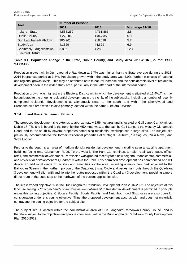
A ‘do nothing’ scenario would involve the subject site, which is zoned for residential development, remaining in its
current state, and remaining underutilised.
Figure 3.6: View of the site from Golf Lane
This would represent a sub-optimal use of zoned and serviced land which is identified for residential development.
The Dun Laoghaire Rathdown Development Plan states the following in relation to housing delivery over the plan
period:
“Actual delivery of housing units over the lifetime of the 2010 – 2016 Plan has been very low as a consequence of
the economic climate and market conditions. Only 260 no. houses were completed in 2013 - creating a huge
anomaly between actual output and projected outputs. However, with latent demand for housing, particularly in the
Dublin Region, and given Government policy as outlined in ‘Construction 2020’ (May 2014) the Development Plan
has a key role to act as a catalyst for positive change and progress and to plan for future growth in the County. The
Council must continue to utilise all policy avenues available to it to ensure the optimum delivery of residential units
over the duration of this Plan from both the public and private sectors. In seeking to secure this objective the
Development Plan response in relation to residential development will focus on three interrelated strands, namely:
• Increasing the supply of housing.
• Ensuring an appropriate mix, type and range of housing.
• Promoting the development of balanced sustainable communities.”
Golf Lane SHD Environmental Impact Assessment Report Chapter 3 – Population and Human Health
Chapter 3/Page 13
The Development Plan goes on to state that the full housing allocation for Dún Laoghaire Rathdown from the RPGs
for the years 2006 to 2022 was 40,385. Between 2006 and 2013, approximately 9,500 units were constructed in
the County, leaving an allocation of 30,885 for the remaining years 2014 to 2022.
The Issues Paper for the new County Development Plan (2022-2028) notes that c. 11,040 units had been subject
to a grant of permission in the county between 2016 and August 2019, indicating a remaining lag in housing
development. The Issues Paper further noted that there were 1,797 units under construction at the time of writing
of the Issues Paper, with a further 9,890 units permitted but not commenced at that time.
The Rebuilding Ireland Action Plan for Housing and Homelessness (2016), the National Planning Framework, and
the Regional Spatial and Economic Strategy for the EMRA all promote the delivery of housing in appropriate
locations in order the meet the considerably shortfall of housing in the state, which is precipitating gravely negative
impacts in terms of population and human health, with an increasing portion of the population living in overcrowded
conditions (as confirmed in the 2016 Census) which can be attributed to a lack of housing supply.
In the do-nothing scenario, the absence of the proposed development would perpetuate the housing shortfall in the
area, contrary to the aims and objectives of national, regional, and local planning and housing policy, all of which
promote the delivery of additional housing at locations such as the subject site.
The local economy would not experience the direct and indirect positive effects of the construction phase of
development, including employment creation. The local construction sector and associated industries and services
would be less viable than they might otherwise be.
Failure to deliver the proposed residential units would result in existing housing need and demand remaining unmet,
at a location where public transport is available. The new pedestrian and cycle links, the public open space, bridge
and the childcare facility, gym, local shop, and resident’s amenity spaces to be provided in the development would
also not be provided.
3.6 POTENTIAL IMPACT OF THE PROPOSED DEVELOPMENT
3.6.1 Introduction
This section provides a description of the specific, direct and indirect, impacts that the proposed development may
have during both the construction and operational phases of the proposed development. As stated, guidance
documents from the EPA, the European Commission, and the Department of Housing, Planning and Local
Government outline that the assessment of impacts on population and human health should focus on the health
issues and environmental hazards arising from the proposed development. A wider consideration of human health
effects which do not relate to the factors identified in the EIA Directive is not required. Additionally, this section
addresses the population and socio-economic impacts of the proposed development.
For a more detailed assessment of potential impacts associated with other environmental factors, please refer to
specific chapters of the EIAR which assess the environmental topics outlined in the EIA Directive. The Construction
and Environmental Management Plan, the Construction and Demolition Waste Management Plan, and the
Operational Waste Management Plan, which are included as standalone reports with this application, also provide
a more detailed assessment of the construction and waste proposals for this development.
3.6.2 Water
Construction Phase
Provision of water infrastructure for the proposed development would involve construction activities within the
subject lands mainly involving trench excavations conducted in parallel with the other services. The potential impact

Golf Lane SHD Environmental Impact Assessment Report Chapter 3 – Population and Human Health
Chapter 3/Page 14
on the local public water supply network would be short term and imperceptible. Therefore the impact on human
health and population in this regard is considered to be insignificant.
During the course of the construction phase of the proposed development, there is potential, in the absence of
mitigation, for surface water runoff to suffer from increased levels of silt or other pollutants, in addition to potential
pollution from spillages, wheel washing and water from trucks on site. The Construction and Environmental
Management Plan, and the Construction and Demolition Waste Management Plan (CDWMP) set out how all
materials will be managed, stored and disposed of in an appropriate manner, mitigating the potential negative
effects as outlined.
Potential impact on water is addressed in Chapter 8 (Water) and a number of mitigation measures are outlined in
in that chapter of this Environmental Impact Assessment Report. These mitigation measures will serve to minimise
potential adverse impacts of the construction phase to the water environment, thereby minimising any associated
risk to human health from water contamination. Therefore, the impact of construction of the proposed development
in relation to water is likely to be short-term and imperceptible with respect to human health.
Operational Phase
Surface water discharge rates will be controlled by a Hydrobrake flow control device, with underground attenuation
tanks provided to store runoff from a 1 in 100-year return period event. SUDS features are implemented in the
surface water drainage network to reduce the rate of runoff.
In the absence of SUDs measures, surface water run-off discharge rates from the development sites may be
increased because of increase in impermeable surfaces, however the implementation of SUDS features proposed
for the subject site including swales, filter drains, and bioretention areas will ensure that any such increased runoff
is attenuated on site with discharge being controlled.
SUDs will be implemented in accordance with the recommendations of Dun Laoghaire Rathdown County Council.
In addition, the ‘The Planning System and Flood Risk Management Guidelines for Planning Authorities’ will be
adhered to. The provision of flow control with storm attenuation will ensure a reduced quantity of surface water
discharging to the outfall, therefore reducing the impact on the receiving system. There is an interaction between
the provision of surface water for the proposed development drainage and the flood potential of the Golf Stream.
Mitigation measures identified in the Site Specific Flood Risk Assessment (SSFRA) by DBFL Consulting Engineers
will ensure there is no adverse effect from the proposed works. This report is submitted as a standalone report as
part of this planning submission.
Further details on the mitigation measures are set out in Chapter 8 (water) of this EIAR. Therefore, the potential
impact on population and human health in this regard is considered to be insignificant.
3.6.3 Noise and Vibration
Construction Phase
Noise and Vibration are addressed in Chapter 10 (Noise and Vibration) which was prepared by AWN Consulting.
During the construction phase there will be extensive site works, involving construction machinery, construction
activities on site, and construction traffic, which will all generate noise. The highest noise levels will be generated
during the general construction activities and during rock excavation. The construction noise levels will only occur
during daytime hours which will serve to minimise the noise impacts at local existing receptors over the course of
the construction phase.

Golf Lane SHD Environmental Impact Assessment Report Chapter 3 – Population and Human Health
Chapter 3/Page 15
The closest neighbouring noise sensitive properties to the proposed development are the residential dwellings that
bound the south and west of the site. The closest is located approximately 20m from the development site, and
over 25 metres from the nearest built element of the proposed development.
During the foundations activity it is predicted that a potentially significant impact may occur at the surrounding noise
sensitive receptors. However, the residual impacts section of Chapter 10 notes that the assessment can be
considered “worst case” and it is unlikely that all items of plant assessed will be in operational simultaneously.
Furthermore, as the impact will be temporary in nature and noise levels will be required to remain within set limits
as provided in Chapter 10, it is reasonable to conclude that there will not be a significant impact on human health
arising.
For all other activities it is predicted that, when taking into consideration of the recommended mitigation measures,
the noise levels from the construction works will not exceed the adopted 70 dB LAeq,1hr threshold. Chapter 10 of this
EIAR sets out mitigation measures in relation to noise.
In relation to vibration during the construction phase, Chapter 10 of this EIAR sets out that the main potential source
of vibration during the construction programme is associated ground breaking during the excavation phase. Chapter
10 confirms that vibration levels at the nearest receptors are not expected to pose any significance in terms of
cosmetic or structural damage.
In terms of disturbance to building occupants, works undertaken within close proximity to the residential receptors
on the site perimeter have the potential to emit perceptible vibration levels. However, it is noted in Chapter 10 of
this EIAR that all construction phase works will be required to comply with the mitigation measures set out therein.
This will include compliance with the noise and vibration criteria under BS 5228:2009+A1:2014 Code of Practice for
Noise and Vibration Control on Construction and Open Sites Parts 1 and 2.
Any construction activities undertaken on the site will be required to operate below the recommended vibration
criteria set out in Chapter 10. Following the implementation of mitigation and based on the standards which will be
maintained, Chapter 10 predicts that vibration impacts during the construction stage will be negative, not significant,
and temporary.
Operational Phase
Once operational, if building services plant items are required to serve the development, the cumulative operational
noise level at the nearest noise sensitive location within the development (e.g. apartments, etc.) will be
designed/attenuated to meet the relevant BS 4142 noise criteria for day and night-time periods.
Plant items with appropriate noise ratings and, where necessary, appropriate sound limits will be specified in order
that the adopted plant noise criteria is achieved at the façades of noise sensitive properties, including those within
the development itself. Further details on the mitigation measures are detailed in Chapter 10 (Noise and Vibration)
of this EIAR.
Chapter 10 of the EIAR confirms that after mitigation, the operational outward noise impact of the proposed
development will be neutral, imperceptible and permanent. The inward noise impact will be neutral, not significant,
and permanent.
The impact of additional traffic on roads is assessed in Chapter 10, with several routes in the surrounding area
assessed based on the likely additional traffic which the development will generate. Chapter 10 states that one
route (Route A) will see a slight, negative, and permanent impact (this is due to the projected opening of the
Glenamuck District Distributor Road before 2038 which will decrease the amount of traffic for both the Do Nothing
and the Do Something scenarios in 2038). Consequently, the rated impact in relation to noise for Route A is

Golf Lane SHD Environmental Impact Assessment Report Chapter 3 – Population and Human Health
Chapter 3/Page 16
considered to be negative, slight and permanent. The impact for all other routes is considered to be neutral,
imperceptible and permanent.
3.6.4 Air Quality & Climate
Construction Phase
During the construction phase, site clearance and ground excavation works have the potential to generate dust
emissions rising from the operation and movement of machinery on site. This could have a potential impact on
population and human health.
Chapter 9 of this EIAR states:
“Dust emissions from the construction phase of the proposed development have the potential to impact human
health through the release of PM10 and PM2.5 emissions. As per Table 9.5 significant PM10 emissions can occur
within 15m of the site for a development of this scale. There are a number of high sensitivity (residential) receptors
to the direct south and west of the site however, only one property is within 15m of the site. Therefore, in the
absence of mitigation there is the potential for slight, negative, short-term impacts to human health as a result of
the proposed development.”
Chapter 9 goes on to state that the potential construction phase impacts shall be mitigated as detailed in Chapter
9 (Air Quality and Climate) of this EIAR. Best practice mitigation measures are proposed for the construction phase
of the proposed development which will ensure the proactive control of dust and other air pollutants to minimise
generation of emissions at source. The mitigation measures that will be put in place during construction of the
proposed development will ensure that the impact of the development complies with all EU ambient air quality
legislative limit values which are based on the protection of human health.
Operational Phase
In relation to Human Health, Chapter 9 of the EIAR states:
“Traffic related air emissions have the potential to impact air quality which can affect human health. However, air
dispersion modelling of traffic emissions has shown that levels of all pollutants are below the ambient air quality
standards set for the protection of human health. It can be determined that the impact to human health during the
operational stage is long-term, negative and imperceptible and therefore, no mitigation is required.”
Chapter 9 goes on to state that traffic-related air emissions have the potential to impact air quality which can affect
human health. However, air dispersion modelling of traffic emissions has shown that levels of all pollutants are
below the ambient air quality standards set for the protection of human health. Chapter 9 determines that the impact
to human health during the operational stage is long-term, negative and imperceptible.
3.6.5 Landscape and Visual Impact
Construction Phase
Construction works can have visual effects on the quality of the surrounding landscape and the setting of nearby
built heritage receptors. The construction effects will vary according to their temporary nature and some operations
may have more perceptible effects than others. This is assessed in Chapter 6 of the EIAR ‘Landscape and Visual
Impacts’.

Golf Lane SHD Environmental Impact Assessment Report Chapter 3 – Population and Human Health
Chapter 3/Page 17
The construction phase will have short term townscape and visual impacts. The impacts are not considered
significant on population and human health. Hoarding is included as part of the mitigation measures for noise and
would minimise visual impact also.
Operational Phase
Please refer to Chapter 6 of the EIAR ‘Landscape and Visual Impacts’ and the accompanying photomontages for
a more detailed assessment. The proposed development will have a beneficial effect on local townscape, including
providing high quality new buildings at a landmark location, providing considerable improvement to the permeability
and legibility of its immediate context, and the quality of the public realm. It will be in accordance with planning
policy for the area, while the overall effect of the development will be moderately positive impact upon landscape
character. Visual impacts on nearby and more distant views range from low, to moderate to moderately positive.
The impact on the large majority of the views assessed will be either neutral or positive.
3.6.6 Economic Activity
Construction Phase
The construction phase of the proposed development is likely to result in a positive net improvement in economic
activity in the area of the proposed development site particularly in the construction sector and in associated
secondary building services industries. The construction sector (including associated services) was documented as
one of the most adversely impacted sectors of the Irish economy following the previous economic downturn in 2008.
Given the economic impact of COVID-19, this development will help to sustain and promote employment.
The construction of the development and all associated infrastructure will precipitate a positive impact on
construction-related employment for the duration of the construction phase.
The construction phase will also have secondary and indirect ‘spin-off’ impacts on ancillary support services in the
area of the site, such as retail services, together with wider benefits in the aggregate extraction (quarry) sector,
building supply services, professional and technical professions etc. These beneficial impacts on economic activity
will be largely temporary but will contribute to the overall future viability of the construction sector and related
services and professions over the construction period.
The proposed development could have a slight negative economic impact on the surrounding area during the
construction phase due to traffic and associated nuisance, dust and noise. These issues and appropriate mitigation
measures are addressed in Chapters 9 & 10 of the EIAR, in the Traffic Impact Assessment, Construction and
Environmental Management Plan and the Construction and Demolition Waste Management Plan which accompany
the application. A Construction Traffic Management Plan will be implemented for the site during the construction
process which will minimise disruption to the surrounding road network. The Construction Management Plan
submitted with the application includes outline construction traffic management measures to be implemented on
site.
Operational Phase
The operational phase of the development will assist with the delivery of additional housing to support planned and
projected population growth which will support a wide range of additional local businesses, services, transport
infrastructure and employment opportunities. The adjacent Park, Carrickmines and the permitted mixed use
neighbourhood centre development adjacent at Q3 will benefit from the increased local populace and allow for
improved local generation of job opportunities. Economic opportunities will also be provided for within the
development in the form of the gym, creche and shop unit which are all proposed.

Golf Lane SHD Environmental Impact Assessment Report Chapter 3 – Population and Human Health
Chapter 3/Page 18
The proposed development will help to meet established housing need and demand within the Dublin area, at a
location which will encourage public transport and active transit modes due to its proximity to high capacity, high
frequency public transport provision, and a broad range of existing and permitted uses, facilities and amenities.
Section 3.6.9 of this chapter examines the impact of the proposed development in terms of housing in further detail.
The proposal includes an element of Part V provision in accordance with the requirements of the Planning Authority,
which will provide for an enhanced mix of tenures, and add to the existing social housing stock. The overall benefit
to the economic activity of the surrounding area resulting from the development can be considered moderate, long
term, and positive.
3.6.7 Social Patterns
Construction Phase
The construction phase of the proposed development is unlikely to have any significant impact on social patterns
within the surrounding area. Some additional temporary additional local populations may arise out of construction
activities. However, these impacts are imperceptible, temporary in nature and therefore not considered significant.
It is acknowledged that the construction phase of the project may have some short-term negative impacts on local
residents. Such impacts are likely to be associated with construction traffic and possible nuisances associated with
construction access requirements. These impacts are dealt with separately and assessed elsewhere in the EIAR,
including Chapter 2 - Project Description and Alternatives Examined, Chapter 9 - Air Quality and Climate and
Chapter 10 - Noise and Vibration and also in the Traffic Impact Assessment report.
Such impacts will be short term and in the longer term, the completed scheme will have beneficial impacts for local
businesses, residents and the wider community. Any disturbance is predicted to be commensurate with the normal
disturbance associated with the construction industry where a site is efficiently, sensitively, and properly managed
having regard to neighbouring activities. The construction methods employed and the hours of work proposed will
be designed to minimise potential impacts to nearby residents. A Construction and Environmental Management
Plan and a Construction and Demolition Waste Management Plan have been prepared and are submitted with this
planning application.
Operational Phase
The addition of new residents and an additional element employment to the area will improve the vibrancy and
vitality of the area and will help to support existing community and social infrastructure, in addition to further
supporting nearby neighbourhood centre and commercial businesses. As set out within the Social and Community
Infrastructure Audit submitted as a standalone report with the application, there is a considerable range of existing
community and social infrastructure within a 2km radius of the subject site, which the proposed development will
be able to avail of.
The Social and Community Infrastructure Audit also demonstrates that the extra demand created by the proposal
for primary and post primary educational facilities will not be significant in relation to current levels of local provision,
while increased levels of demand from the scheme is unlikely to result in significant impact on existing services.
This includes facilities which are marginally outside the 2km radius as felt appropriate given the accessibility of the
proposal to public transport. Furthermore, it is noted that there are plans being progressed and permissions in place
for additional schools to serve the local area, including school facilities within the Cherrywood SDZ, and a permitted
school at Mimosa / Levmoss. Therefore, while demand for schools in the area is likely to increase based on
permitted and future development in the area, the necessary schools infrastructure is actively being progressed to
meet increase in demand.
Golf Lane SHD Environmental Impact Assessment Report Chapter 3 – Population and Human Health
Chapter 3/Page 19
The proposed development includes the provision of a childcare facility with a GFa of 300 sq.m. As set out within
the Community and Social Infrastructure Audit report, this childcare facility will accommodate the likely demand
arising from the proposed development based on the calculation methodology within the 2001 Childcare Facility
Guidelines.
A gym facility of 340 sq.m in area is proposed as part of the development. This is intended to further support the
needs of those living within the development and provide a local area for socialising and exercise. This facility will
further complement the wider sports facilities identified within the Social and Community Infrastructure Audit report,
which can be noted for a lack of gym facilities.
The proposed development also includes a range of resident’s amenity spaces. Block B0 includes an amenity and
concierge space at ground floor level with a gross floor area of 171 sq.m. A further multi-purpose event space for
entertaining is located at the top of this landmark building, comprising 83 sq.m over two levels, affording panoramic
views of the area. Within Block D, a further concierge space of 99 sq.m is provided at ground floor, with a large
amenity space provided at first floor level (292 sq.m), which could accommodate film screenings, functions, and
events. The space is intended to provide for a social space in which residents can interact and socialise, fostering
a community spirit among residents and further enhancing the high quality communal areas to be provided within
the development.
Once operational, the proposed development will give rise to much needed additional residential accommodation.
Residents will spend a portion of their income locally which would not happen without the proposed development.
The proposed development provides for a childcare facility, a gym and a shop unit. The proposed development will
provide long term job opportunities for people living in the area., in addition to those construction and development
jobs provided during the construction phase.
The current planning application is accompanied by a Social and Community Infrastructure Audit report prepared
by John Spain Associates, which confirms that the area within which the proposed development is situated has the
necessary community and social infrastructure to support the proposal.
Having regard to the fact that the area within which the development is situated benefits from a good level of social
and community infrastructure, and noting the elements of the proposed development which will improve and
strengthen this infrastructure, it is concluded that the proposed development will precipitate a moderate, positive,
long term impact on social patterns in the operational phase.
3.6.8 Land-Use & Settlement Patterns
Construction Phase
The construction phase of the proposed development will primarily consist of site clearing, excavation and
construction works, and the erection of the proposed new buildings on site and has the potential to impact adversely
and result in the temporary degradation of the local visual environment on a short-term basis. The visual impacts
precipitated by the proposed development are assessed in greater detail in Chapter 6 of the EIAR ‘Landscape and
Visual Impacts’ The site has been formerly occupied by 5 no. detached dwellings with large private gardens. These
dwellings have since been demolished and so no habitable dwellings are on site.
Secondary land use impacts include off-site quarry activity and appropriate disposal sites for removed spoil and
other materials transported off site. The Construction and Demolition Waste Management Plan addresses these
issues in more detail.
The phase may result in a marginally increased population in the wider area due to increased construction
employment in the area, however, this would be temporary in nature and the impact would be imperceptible.

Golf Lane SHD Environmental Impact Assessment Report Chapter 3 – Population and Human Health
Chapter 3/Page 20
Operational Phase
The operational phase of the proposed development will result in the introduction of a greater intensity and density
of residential development, delivering wider public realm improvements, in accordance with national and local
planning policy objectives which seeks to deliver compact growth at suitable locations. Adequate provision of high-
quality housing to serve the existing and future population of the county and the wider Dublin area is an important
pre-requisite and contributor to the establishment and maintenance of good human / public health. The high quality
design of the proposed development, including individual units which meet and exceed the relevant standards for
apartments as set out within the apartment guidelines will contribute to a positive impact on the wellbeing of future
residents.
The location of the development, nearby to high capacity light rail and proximate to bus services, including the
ample provision of bicycle parking facilities on site, encourages the use of sustainable transport, which has positive
public and human health implications when compared to development at less accessible locations which encourage
reliance on private cars. In addition to the proximate Luas stop, the site is also located in close proximity to bus
routes operating along Ballyogan Road and Glenamuck Road. The 63 bus route provides services from Dun
Laoghaire to Kilternan, with c. 20 minute frequencies. Glenamuck Road is well served by existing pedestrian and
cycle facilities, with Ballyogan Road also benefiting from good quality facilities. The nearby Luas stop provides an
opportunity to avail of high capacity, high frequency services between Brides Glen to the City Centre and onwards
to Broombridge in the north of the city.
3.6.9 Housing
Construction Phase
While the subject site formerly accommodated several residential dwellings, these were demolished some years
ago. Therefore, the proposed development will not result in any impact in terms of loss of housing stock during the
construction stage.
The impact of the development once operational is set out below.
Operational Phase
The operational phase of the proposed development will see the delivery of 482 residential units, all of which will
be apartments. This represents a large-scale development in the context of the housing delivery within Dun
Laoghaire Rathdown, with housing completions numbering c. 1,000-1,300 units in the County for the years 2016-
2018.
The proposed development will respond to established housing need and demand in the area of the proposed
development, and the wider region. The proposed residential units will assist in addressing the significant shortfall
of residential development, which has been further impacted by the ongoing Covid 19 crisis.
The proposed development delivers a range of housing unit sizes, including studio, one, two, and three bedroom
apartments. Resident’s amenities and local commercial uses (including a gym, local shop, and childcare facility)
are also provided. The scheme also benefits from a high level of good quality communal and public open space,
with new linkages provided through the site improving connectivity.
The delivery of 482 no. well designed residential units at an appropriate location will have a direct, positive, and
significant impact on the future residents of the proposed development and will support the population growth
targeted for the area and Dublin as a whole.

Golf Lane SHD Environmental Impact Assessment Report Chapter 3 – Population and Human Health
Chapter 3/Page 21
3.6.10 Employment
The impact of the proposed development in relation to employment has been discussed under economic activity.
3.6.11 Health & Safety
No significant health and safety effects are envisaged during either the construction or operational phases of the
proposed development. The Health and Safety policy, procedures and work practices of the proposed development
will conform to all relevant health and safety legislation both during the construction and operational stages of the
proposed development. The proposed development will be designed and constructed to best industry standards,
with an emphasis being placed on the health and safety of employees, local residents and the community at large.
Construction Phase
The construction methods employed and the hours of work proposed will be designed to minimise potential impacts.
The development will comply with all Health & Safety Regulations during the construction of the project. Where
possible, potential risks will be omitted from the design so that the impact on the construction phase will be reduced.
A Construction and Environmental Management Plan has been prepared by DBFL Consulting Engineers and the
measures specified therein will be complied with during the construction phase of the project.
Operational Phase
The operational stage of the development is unlikely to precipitate any significant impacts in terms of health and
safety. The design of the proposed development has been formulated to provide for a safe environment for future
residents and visitors alike. The paths, roadways and public areas have all been designed in accordance with best
practice and the applicable guidelines including DMURS. A quality audit has been undertaken which has informed
the design and which is submitted as part of the application. Likewise, the proposed residential units and childcare
facility accord with the relevant guidelines and will meet all relevant safety and building standards and regulations,
ensuring a development which promotes a high standard of health and safety for all occupants and visitors.
The proposed development will not result in any significant impacts on human health and safety once completed
and operational.
3.6.11 Risk of Major Accidents or Disasters
Construction Phase
Having regard to the topography, nature and location of the subject site, and based on the location of the built
elements of the development within Flood Zone C as established in the Site Specific Flood Risk Assessment
prepared by DBFL submitted with the application, it is not considered likely that there will be any impact related to
a major accident or disaster during the construction phase of the proposed development, stemming internally from
within the development, or externally.
The works proposed in proximity to roadways will be governed by best practice and appropriate safety procedures,
ameliorating any risk of a major accident in those contexts.
Operational Stage
The proposed development will be located on land which is not at any significant risk of flooding. A site specific
flood risk assessment (SSFRA) has been carried out by DBFL Consulting Engineers for the subject site and is
included as a standalone report. The SSFRA includes hydraulic modelling of the Golf Stream to verify the extents

Golf Lane SHD Environmental Impact Assessment Report Chapter 3 – Population and Human Health
Chapter 3/Page 22
of the floodplain through the site. The SSFRA concluded that the proposed development is appropriate for the site’s
flood zone categories and that the proposed development is considered to have the required level of flood
protection.
Therefore, it is considered that there is no significant risk related to major accidents or disasters, external or internal,
man-made or natural in respect of the proposed development.
3.7 AVOIDANCE, REMEDIAL & MITIGATION MEASURES
Avoidance, remedial and mitigation measures describe any corrective or mitigative measures that are either
practicable or reasonable, having regard to the potential likely and significant environmental impacts.
Construction Phase
A range of construction related remedial and mitigation measures are proposed throughout this EIAR document
with reference to the various environmental topics examined and the inter-relationships between each topic.
Readers are directed to Chapter 14 of this EIAR document which summarises all of the remedial and mitigation
measures proposed as a result of this EIAR.
In particular, the mitigation measures relating to construction phase referenced in Chapter 2 are also relevant to
Chapter 3 and therefore will not be repeated herein.
Operational Phase
The operation phase is considered to have likely positive impacts on human beings in relation to the provision of
additional residential units, gym, childcare facility and local shop uses, and high-quality open space and
pedestrian/cyclist facilities to cater for the demands of a growing population and encourage active travel modes in
accordance with the principles of sustainable development and fully utilising the public transport provision nearby
to the subject site. No further specific mitigation is required having regard to the mitigation included within the other
chapters of this EIAR.
3.8 POTENTIAL CUMULATIVE IMPACTS
The potential cumulative impacts of the proposed development on population and human health have been
considered in conjunction with the ongoing changes in the surrounding area. Visits to the subject site and
surrounding area and desk-based review of online planning files have been undertaken to identify the existing
pattern of development, nearby uses, and any permitted / ongoing developments of relevance to the current
proposals in the context of population and human health. The surrounding area is defined by a broad and varied
mix of uses, including residential, commercial, recreational and civic uses. Permitted and ongoing developments in
the area include several residential, commercial, and infrastructure developments permitted and under construction
including at the Park, Carrickmines and in particular Quadrant 3 of the Park. Furthermore, the ongoing development
of the wider area, including the Cherrywood SDZ, Kilternan / Glenamuck and the Ballyogan and Environs Local
Area Plan area will see the delivery of a further range of necessary and appropriate range of facilities and services
concurrently with the growth of the population of the area.
These developments will influence demographic change, population growth, and the intensity of commercial use in
this area, cumulatively contributing to increasing population and employment growth in the wider area which
represents a positive cumulative impact which accords with the planning policy context for the area. The planning
policy context, including the County Development Plan, the Ballyogan and Environs LAP, and the Cherrywood SDZ
Planning Scheme provide for the necessary and appropriate range of facilities and services in the area which will
deliver further improvements in service provision in line with the planned population growth.

Golf Lane SHD Environmental Impact Assessment Report Chapter 3 – Population and Human Health
Chapter 3/Page 23
The cumulative impact of the proposed development, along with other permitted and existing developments in the
vicinity, will be a further increase in the population of the wider area. This will have a moderate impact on the
population (human beings) in the area. This impact is likely to be long term and is considered to be positive, having
regard to the zoning objective for the subject lands, and their strategic location in close proximity to public transport,
and the high level of demand for new housing in the area. The impact of this cumulative population growth is likely
to increase demand for educational facilities and other services in the medium term, however it is noted that the
ongoing improvement of services in the area is provided for under the local planning policy framework, including
the provision of additional schools to meet increases in demand. A new school is permitted at Mimosa / Levmoss
to the northwest of the subject site, while
With regard to human health, the cumulative impact of the proposed development in conjunction with other nearby
developments will provide for the introduction of a high quality, new neighbourhood in the area with a high level of
accessibility and amenity. The overall cumulative impact of the proposed development will therefore be long term
and positive with regard to human health, as residents will benefit from a high quality, visually attractive living
environment, with strong links and pedestrian permeability. Having regard to the assessment of cumulative impacts,
it is not considered that any additional mitigation measures are required further to those which are outlined above.
3.9 PREDICTED / RESIDUAL IMPACTS OF THE PROPOSED DEVELOPMENT
This section allows for a qualitative description of the resultant specific direct, indirect, secondary, cumulative, short,
medium and long-term permanent, temporary, positive and negative effects as well as impact interactions which
the proposed development may have, assuming all mitigation measures are fully and successfully applied. It should
be noted that in addition to remedial and mitigation measures, impact avoidance measures have also been built
into the EIA and project design processes through the assessment of alternatives described in Chapter 2 of this
EIAR document.
Construction Phase
The construction phase of the proposed development will primarily consist of site clearance, excavation and
construction works, which will be largely confined to the proposed development site. Notwithstanding the
implementation of remedial and mitigation measures there will be some minor temporary residual impacts on
population (human beings) and human health most likely with respect to nuisance caused by construction activities,
predominantly related to noise and traffic as detailed.
It is anticipated that subject to the careful implementation of the remedial and mitigation measures proposed
throughout this EIAR document, and as controlled through the Construction and Environmental Management Plan,
any adverse likely and significant environmental impacts will be avoided. Positive impacts are likely to arise due to
an increase in employment and economic activity associated with the construction of the proposed development.
The overall predicted likely impact of the construction phase will be short-term and neutral.
Operational Phase
The proposed development will result in a positive alteration to the existing underutilised site in terms of the provision
of residential units and community facilities to serve the growing population of the area in accordance with national
and regional planning policy.
Positive impacts on population and human health will include health benefits associated with the provision of a
significant number of modern, well-designed and sustainable housing units, a high-quality environment, public open
space and improvements to the public realm which creates a highly permeable layout that encourages walking and
cycling, amenity and recreational facilities, including use of public transport options and local retail and commercial
offerings, both on site, at the existing Park, Carrickmines and the permitted Q3 development adjacent.

Golf Lane SHD Environmental Impact Assessment Report Chapter 3 – Population and Human Health
Chapter 3/Page 24
The implementation of the range of remedial and mitigation measures included throughout this EIAR document is
likely to have the impact of limiting any adverse significant and likely environmental impacts of the operational phase
of the proposed development on population and human health.
3.10 MONITORING
In relation to the impact of the development on population and human health it is considered that the monitoring
measures outlined in regard to the other environmental topics such as water, air quality and climate and noise and
vibration sufficiently address monitoring requirements.
3.11 REINSTATEMENT
While not applicable to every aspect of the environment considered within the EIAR, certain measures may be
proposed to ensure that in the event of the proposal being discontinued, there will be minimal impact to the
environment.
There are no reinstatement works proposed specifically with respect to population and human health. Alleviation of
fluvial flooding of the subject site due to the reinstatement of the overland flow path between the Golf Stream and
the M50 is however envisaged.
3.12 INTERACTIONS
As referenced throughout the chapter, there are numerous inter-related environmental topics described in detail
throughout this EIAR document which are of relevance to human health. This chapter of the EIAR has been
instructed by updated guidance documents reflecting the changes within the 2014 EIA Directive. These documents
include the EU and Irish guidelines for preparation of an EIAR and carrying out an EIA. Therefore, in line with the
guidance documents referred to, this chapter of the EIAR focuses primarily on the potential likely and significant
impact on Population and Human Health in relation to health effects/issues and environmental hazards from the
other environmental factors and interactions that potentially may occur.
Where there are identified associated and inter-related potential likely and significant impacts which are more
comprehensively addressed elsewhere in this EIAR document, these are referred to. However, the relevant
environmental topic chapter of this EIAR document contains a more detailed assessment in respect of the
interaction of each environmental topic with population and human health.
3.13 DIFFICULTIES ENCOUNTERED IN COMPILING CHAPTER
No significant difficulties were experienced in compiling this chapter of the EIAR document.
3.14 CONCLUSION
This chapter of the EIAR has provided an assessment of the likely impact of the proposed development on
population and human health. As set out above, the proposed development will result in a positive impact on housing
and is not likely to result in any significant adverse effects on population and human health, and will result in some
other positive impacts, including settlement patterns of a sustainable density at an appropriate location and
economic benefits derived from the employment opportunities within the gym, shop and childcare facility proposed.
Through generating additional economic activity in the area and providing for a high standard of residential
accommodation, there will be a significant positive impact arising from the proposed development.

Golf Lane SHD Environmental Impact Assessment Report Chapter 3 – Population and Human Health
Chapter 3/Page 25
3.15 REFERENCES
• National Planning Framework 2018
• Regional Spatial and Economic Strategy for the EMRA, 2019
• Dun Laoghaire Rathdown County Development Plan 2016-2022
• Ballyogan and Environs Local Area Plan 2019-2025
• 2020 Labour Force Survey Q3 – www.cso.ie
• 2020 Labour Force Survey Q2– www.cso.ie
• 2020 Labour Force Survey Q1 – www.cso.ie
• 2019 Labour Force Survey Q4 – www.cso.ie
• ESRI Quarterly Economic Commentary, Autumn 2020
• Central Statistics Office www.cso.ie
• Central Bank of Ireland - Population Change and Housing Demand in Ireland 10 December 2019