Embed Size (px)
Citation preview
Chapter 3. Minimum Control Requirements 3.1 Introduction This chapter establishes the minimum stormwater control standards necessary to implement the
Southern Lowcountry Stormwater Ordinance within the Town of Bluffton. The term “runoff reduction” is
used throughout this chapter to describe the retention of the stormwater on site. The SWRv is used to
describe the volume of stormwater to be retained on site.
Two levels of stormwater retention are prescribed, the 85th and the 95th percentile storm, and are
assigned based on a site’s subwatershed as identified by the U.S. Geological Survey Hydrologic Unit
Code 12 (HUC-12) presented in Section 3.5.1 below. In addition, peak discharge control of the post-
development 2-, 10- , and 25-year, 24-hour storms for the General and Savannah Watershed Protection
Areas and 2-, 10- , 25-, 50- and 100-year, 24-hour storms for the Bacteria and Shellfish Watershed
Protection Area to their predevelopment flow shall be provided by a combination of structural controls,
GI/LID practices and other non-structural BMPs. As well, requirements to manage the 100-yr, 24-hour
storm event are provided in the extreme flood event section below Further, this Manual and
Appendices provide the framework and necessary tools to document the methods proposed by
development plans to comply with these requirements. It should be noted that stormwater ponds are
considered the least favorable structural best management practice to meet the SWRv and water quality
requirements of this Manual.
3.2 Regulated Site Definition According to the Unified Development Ordinance, the design criteria of this Manual shall be applicable
to any new development, redevelopment or major substantial improvement activity, including, but not
limited to, Development Plan applications, site plan applications, grading plan applications, public
improvement projects, and subdivision applications that meet the applicability standards found in
Chapter 1.4.
The Southern Lowcountry stormwater design requirements are applied according to the flow chart in
Error! Reference source not found.1 and should be determined as follows:
1) In sequence, first determine which HUC-12 watershed that the project is in according to
Error! Reference source not found.. Stormwater design criteria for the development follows
the watershed area in which it is located. Next, determine the square feet of impervious
area to be created, added or replaced as a part of the development or redevelopment. Does
it equal or exceed 5,000 square feet? Or will the project disturb greater than 1 acre? If the
answer is “yes” to either of these questions, the project plan must meet the requirements
for stormwater management in this Manual for their respective watershed area.
2) If a project is a major substantial improvement, it must meet the water quality criteria for its
respective watershed protection area to the maximum extent practicable (MEP) or obtain
off-site stormwater credit. The terms MEP and off-site stormwater credit are further
explained in Section 3.9 and 3.10 below. Peak control requirements do not apply to major
substantial improvement projects.
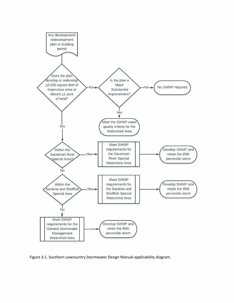
Figure 3.1. Southern Lowcountry Stormwater Design Manual applicability diagram.
3.3 Infill & Redevelopment An infill project is one on a previously platted property that may or may not have stormwater
management capacity in its original development plan. Regardless of size, infill that is part of a larger
common plan of development, even through multiple, separate, and distinct land disturbing activities
that may take place at different times and on different schedules must comply with this Manual. Such
projects may include Planned Unit Developments (PUDs) that have stormwater systems built that do not
meet the requirements of this Manual. If the proposed project meets the applicability criteria of Section
1.4.1, the stormwater plan review in this Manual is necessary. If the development’s original stormwater
management plan is sufficient to meet the current requirements of this Manual and is documented
through approved plans and as-built drawings, or current field measurements and engineering
calculations, no further stormwater requirements must be met. When the infill project is part of an
original plan that does not meet the current stormwater requirements, the level of stormwater
management that is provided in the current development may be credited toward the current volume
and hydrologic analysis. Infill locations that, due to the municipal jurisdiction’s zoning or land use
requirements or site conditions, cannot meet the requirements of this Manual must complete the
maximum extent practicable (MEP) evaluation in Section 3.9 for project approval.
Similarly, redevelopment may be credited for the level of stormwater in place. If the redevelopment’s
original stormwater management plan is sufficient to meet the current requirements of this Manual and
is documented through approved plans and as-built drawings, or current field measurements and
engineering calculations, no further stormwater requirements must be met. When the redevelopment is
part of an original plan that does not meet the current stormwater requirements, the level of
stormwater management that is provided in the current development may be credited toward the
current volume and hydrologic analysis. Redevelopment projects that, due to the municipal jurisdiction’s
zoning or land use requirements or site conditions, cannot meet the requirements of this Manual must
complete the maximum extent practicable (MEP) evaluation in Section 3.9 for project approval.
3.4 Stormwater Runoff Quality & Peak Discharge Control Since its inception, the Clean Water Act was designed to address the water quality impacts of
stormwater runoff. As it has been applied through successive stormwater permit cycles, the Act’s
requirements have been interpreted to mean application of stormwater best management practices to
the maximum extent practicable. The U.S. Environmental Protection Agency (EPA) has stated that such
conditions include specific tasks or best management practices (BMPs), BMP design requirements, and
performance requirements (EPA, 81 Fed. Reg. 3).
Consistent with the EPA’s Phase II MS4 permit, this Manual requires that stormwater runoff shall be
adequately treated before it is discharged from a development site. A stormwater management system
is assumed to meet the stormwater runoff quality criteria by satisfying the stormwater runoff volume
criteria for its respective Watershed Area presented in this Manual. If any of the required stormwater
runoff volume cannot be reduced on the site, due to impractical site characteristics or constraints, the
following questions shall be addressed in the permitting process:
1. Can the required stormwater volume be obtained from an adjacent site owned or available for stormwater retention purposes;
2. Is there available stormwater retention volume within the adjacent right-of-way and available through fee-in-lieu arrangements within this jurisdiction; and
3. Is a waiver granted based on a maximum extent practicable evaluation?
Further, a stormwater management system is presumed to comply with these criteria if:
• It intercepts and treats stormwater runoff in stormwater management practices that have been
selected, designed, constructed and maintained in accordance with this Manual;
• It is provided with documentation to show that total suspended solids, nitrogen and bacteria
removal were considered during the selection of the stormwater management practices that
will be used to intercept and treat stormwater runoff on the development site;
• It is designed to provide the amount of stormwater load reduction specified in the latest edition
of this Manual; and
• It manages the peak flow and extreme flood event storms in accordance with this Manual.
3.5 Southern Lowcountry Stormwater Management Performance Requirements Stormwater management requirements of this Manual are intended to enhance the quality of
development, protect and enhance stormwater quality and management, protect aquatic resources
from the negative impacts of the land development process, address water quality impairments or a
total maximum daily load, as identified by the South Carolina Department of Health and Environmental
Control (DHEC), or address localized flooding issues.
3.5.1 Watershed Protection Area Designations
Not all watersheds of the Southern Lowcountry region require the same level of post-construction
stormwater management. Currently, three watershed protection areas are designated with specific
unique stormwater management requirements based on the current and anticipated water quality
control measures for their contributing watersheds. The Southern Lowcountry Stormwater Ordinance
provides the Town of Bluffton the flexibility and authority to designate subwatersheds or drainage areas
as Special Watershed Protection Areas that lead to more restrictive requirements or special criteria.
Such special designations and criteria will be provided as Appendix P to this Manual.
In the Southern Lowcountry, impairments include recreational water use impairment from bacteria
(Enterococcus for saltwater and E. coli for freshwater), aquatic life use impairment from turbidity or
dissolved oxygen, and shellfish harvesting use impairment from fecal coliform bacteria. Stormwater best
management practices for these types of impairments include erosion and sediment control for
turbidity impairments, illicit discharge detection, vegetated conveyances, vegetated buffers, pet waste
programs, and post-construction runoff control. Currently, Southern Lowcountry water quality
impairments do not include nutrient impairments, but nutrients can also be addressed through erosion
and sediment control and the stormwater best management practices outlined in this Manual.
Most of Beaufort County and the lower reaches of the Jasper County watersheds have shellfish receiving
waters or are recreational waters and are therefore sensitive to bacteria impairments. Land
development and redevelopment projects in these watersheds require greater scrutiny to ensure that
low impact development methods are designed, implemented and maintained to be protective of these
water uses.
Watersheds tributary to the Savannah River in the Southern Lowcountry include most of the freshwater
wetlands of the region. River water quality is excellent and is a supply for drinking water for the City of
Savannah and the Beaufort Jasper Water and Sewer Authority. Savannah River impairments

downstream of the I-95 bridge are primarily aquatic life use due to low dissolved oxygen. Since the
Savannah River is the boundary of Georgia and South Carolina, it is reasonable to align stormwater
requirements within Jasper County with those in Chatham and Effingham Counties, GA. Stormwater
permits for the Georgia jurisdictions require use of the Georgia Coastal Stormwater Supplement to the
Georgia Stormwater Management Manual, which is primarily a green infrastructure/low impact
development (GI/LID) design Manual with requirements specific to the Georgia coastal counties.
The remaining watersheds of the Southern Lowcountry are more upland areas and in agricultural or
silvicultural use or are conservation lands. For these areas new development is subject to stormwater
management requirements similar to previous county requirements. This Manual unifies stormwater
management standards across the designated watersheds rather than differing across county or
jurisdictional lines.
The map in Figure 3.2 outlines the boundaries of the three watershed protection areas of the Southern
Lowcountry. Requirements specific to each area are further developed in this chapter. Table 3.1 lists the
US Geological Survey 12-Digit Hydrologic Unit Code (HUC-12) for the watersheds in each area. To
identify a site’s HUC-12, refer to the South Carolina DHEC Watershed Atlas, available online at
https://gis.dhec.sc.gov/watersheds/. After identifying the site’s HUC 12, use Table 3.2 to identify the
watershed protection area.
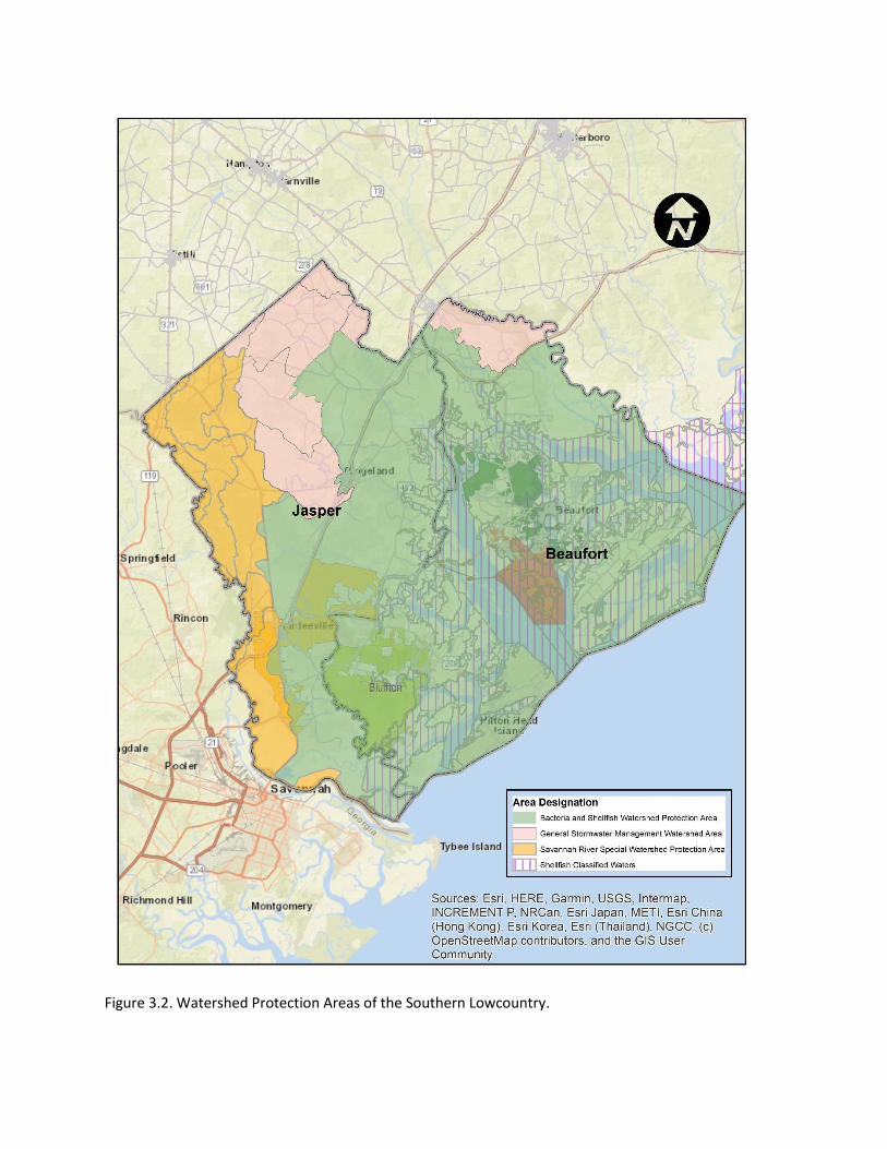
Figure 3.2. Watershed Protection Areas of the Southern Lowcountry.
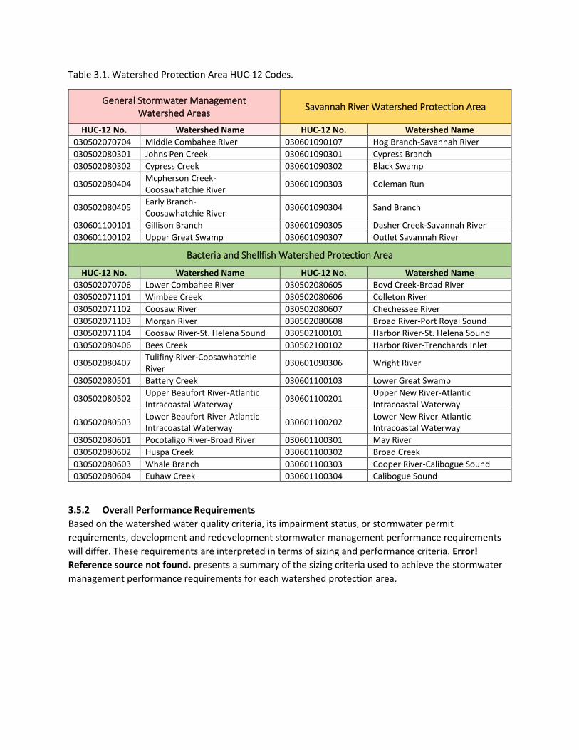
Table 3.1. Watershed Protection Area HUC-12 Codes.
General Stormwater Management Watershed Areas
Savannah River Watershed Protection Area
HUC-12 No. Watershed Name HUC-12 No. Watershed Name 030502070704 Middle Combahee River 030601090107 Hog Branch-Savannah River 030502080301 Johns Pen Creek 030601090301 Cypress Branch 030502080302 Cypress Creek 030601090302 Black Swamp
030502080404 Mcpherson Creek-Coosawhatchie River
030601090303 Coleman Run
030502080405 Early Branch-Coosawhatchie River
030601090304 Sand Branch
030601100101 Gillison Branch 030601090305 Dasher Creek-Savannah River 030601100102 Upper Great Swamp 030601090307 Outlet Savannah River
Bacteria and Shellfish Watershed Protection Area
HUC-12 No. Watershed Name HUC-12 No. Watershed Name
030502070706 Lower Combahee River 030502080605 Boyd Creek-Broad River
030502071101 Wimbee Creek 030502080606 Colleton River
030502071102 Coosaw River 030502080607 Chechessee River
030502071103 Morgan River 030502080608 Broad River-Port Royal Sound
030502071104 Coosaw River-St. Helena Sound 030502100101 Harbor River-St. Helena Sound
030502080406 Bees Creek 030502100102 Harbor River-Trenchards Inlet
030502080407 Tulifiny River-Coosawhatchie River
030601090306 Wright River
030502080501 Battery Creek 030601100103 Lower Great Swamp
030502080502 Upper Beaufort River-Atlantic Intracoastal Waterway
030601100201 Upper New River-Atlantic Intracoastal Waterway
030502080503 Lower Beaufort River-Atlantic Intracoastal Waterway
030601100202 Lower New River-Atlantic Intracoastal Waterway
030502080601 Pocotaligo River-Broad River 030601100301 May River
030502080602 Huspa Creek 030601100302 Broad Creek
030502080603 Whale Branch 030601100303 Cooper River-Calibogue Sound
030502080604 Euhaw Creek 030601100304 Calibogue Sound
3.5.2 Overall Performance Requirements
Based on the watershed water quality criteria, its impairment status, or stormwater permit
requirements, development and redevelopment stormwater management performance requirements
will differ. These requirements are interpreted in terms of sizing and performance criteria. Error!
Reference source not found. presents a summary of the sizing criteria used to achieve the stormwater
management performance requirements for each watershed protection area.
Table 3.2. Watershed Area Overall Performance Requirements.
General Stormwater Management Watershed Protection Areas
Savannah River Watershed Protection Area
Overall Performance Requirements Overall Performance Requirements
• Water Quality: Implement Better Site Design, maintain pre-development hydrology of the site to the Maximum Extent Practicable (MEP) for the 85th percentile storm event.
• Peak Control: Control post-development peak runoff discharge rate to pre-development rate for: 2-, 10- and 25-year, 24-hour design storm events.
• Accommodate the 100-year, 24-hour storm event conveyance through the site and downstream without causing damage/inundation to structures. Provide 10% rule analysis.
• As a pollutant removal minimum, intercept and treat stormwater runoff volume to at least an 80 percent reduction in total suspended solids load, 30 percent reduction of total nitrogen load and 60 percent reduction in bacteria load.
• Complete a natural resources inventory for new site development applications.
• Water Quality: Implement Better Site Design, retain the 85th percentile storm event on-site to the MEP or obtain off-site credit.
• Peak Control: Control post-development peak runoff discharge rate to pre-development rate for: 2-, 10-and 25-year, 24-hour design storm events.
• Accommodate the 100-year, 24-hour storm event conveyance through the site and downstream without causing damage/inundation to structures. Provide 10% rule analysis.
• As a pollutant removal minimum, intercept and treat stormwater runoff volume to at least an 80 percent reduction in total suspended solids load, 30 percent reduction of total nitrogen load and 60 percent reduction in bacteria load.
• Complete a natural resources inventory for new site development applications.
Rationale Rationale
The previous Jasper County stormwater design manual specified these overall performance requirements.
The Savannah River watershed adjoins Georgia counties that are subject to similar overall performance requirements as outlined in the Georgia Coastal Stormwater Supplement.
Bacteria and Shellfish Watershed Protection Area
Overall Performance Requirements • Water Quality: Implement Better Site Design and
retain the 95th percentile storm on-site with approved infiltration/filtering BMPs. Fulfill MEP requirements or, as a last resort, fulfill off-site credit and/or fee-in-lieu requirements.
• As a pollutant removal minimum, intercept and treat stormwater runoff volume to at least an 80 percent reduction in total suspended solids load, 30 percent reduction of total nitrogen load and 60 percent reduction in bacteria load.
• Peak control: Control the post-development peak runoff discharge rate for the 2, 10, 25, 50 and 100-year, 24-hour design storm events to the pre-development discharge rates.
• Accommodate the 100-year, 24-hour storm event conveyance through the site and downstream without causing damage/inundation to structures. Provide 10% rule analysis.
• Complete a natural resources inventory for new site development applications.
Rationale
The Bacteria and Shellfish Watershed Protection Areas are either impaired or have TMDLs, or the receiving waters are classified for shellfish harvesting. These watersheds require greater protection due to their Clean Water Act status or water quality classification. The site’s natural resource inventory is a necessary component of permit application.

3.5.3 Southern Lowcountry Stormwater Precipitation & Runoff
As in the natural environment, a site’s stormwater runoff volume depends upon soil conditions and land
cover. To evaluate each site’s development plan, this Manual relies on the rainfall runoff estimating
methods of the Natural Resources Conservation Service National Engineering Handbook (NEH).
Sometimes referred to as the curve number method or soil cover complex method, NEH chapter 9
describes the runoff response to rainfall events based on hydrologic soil group (HSG A, B, C or D) and
land cover type with an integer between 29 and 100 (NRCS, 2004). Accordingly, information
documenting the site’s soils, their permeability, predeveloped land use or natural cover, and post-
developed land cover, as well as the shallow groundwater table, are required in development plans in
order to review and permit the development activity (Appendix R – Land Cover Designations).
Precipitation event size and distribution are set by this Manual for the three watershed protection areas
that make up the Southern Lowcountry.
The precipitation event distribution terms used in this Manual are defined as follows:
85th Percentile Storm is the 24-hour rainfall amount that according to the National Oceanic and
Atmospheric Administration records for the past 30 years in which 85% of all rainfall events do
not exceed at the nearest US Weather Service station to the County seat. For the General
Stormwater Management Watershed Areas and the Savannah River Watershed Protection
Areas, this number is 1.16 inches of rainfall.
95th Percentile Storm is the 24-hour rainfall amount that according to the National Oceanic and
Atmospheric Administration records for the past 30 years in which 95% of all rainfall events do
not exceed at the nearest US Weather Service station to the County seat. For the Bacteria and
Shellfish Watershed Protection Areas this is 1.95 inches of rainfall.
Plans submitted for new development or redevelopment must demonstrate through accepted
hydrologic methods that the development at post-construction will attenuate and treat the prescribed
storm events. This includes volume reduction, peak flow management and extreme flood protection
both on site and downstream.
3.5.4 Savannah River Watershed Protection Area
Upon implementation of this Manual, any applicable new development, redevelopment or major
substantial improvement in the designated HUC-12 watersheds that are part of the Savannah River
watershed shall meet the following requirements:
• Complete a natural resources inventory for new site development applications.
• Document use of Better Site Design.
• Retain the 85th percentile storm event on-site to the MEP or obtain off-site credit.
• Control the post-development peak runoff discharge rate for the 2, 10 and 25-year, 24-hour design storm events to the pre-development discharge rates.
• Accommodate 100-year, 24-hour storm event through the development without causing damage to the on-site and offsite structures. Provide 10% rule analysis.
• At a minimum, intercept and treat stormwater runoff volume to at least an 80 percent reduction in total suspended solids load, 30 percent reduction of total nitrogen load and 60 percent reduction in bacteria load.
3.5.5 Bacteria & Shellfish Watershed Protection Area
Upon implementation of this Manual, any applicable new development, redevelopment or major
substantial improvement in the designated HUC-12 watersheds that are part of the Bacteria and
Shellfish Watershed Protection Area shall meet the following requirements:
• Complete a natural resources inventory for new site development applications.
• Document use of Better Site Design.
• Retain the 95th percentile storm on-site with approved infiltration/filtering BMPs.
• Fulfill MEP requirements or, as a last resort, fulfill off-site credit and/or fee-in-lieu requirements.
• At a minimum, intercept and treat stormwater runoff volume to at least an 80 percent reduction in total suspended solids load, 30 percent reduction of total nitrogen load and 60 percent reduction in bacteria load.
• Control the post-development peak runoff discharge rate for the 2, 10, 25, 50 and 100-year, 24-hour design storm events to the pre-development discharge rates.
• Accommodate the 100-year, 24-hour storm event conveyance through the site and downstream without causing damage/inundation to structures. Provide 10% rule analysis.
3.5.6 General Stormwater Management Watershed Area
Upon implementation of this Manual, any applicable new development, redevelopment or major
substantial improvement in the designated HUC-12 watersheds for the General Stormwater
Management Watershed Area shall meet the following requirements:
• Complete a natural resources inventory for new site development applications.
• Document use of Better Site Design.
• Maintain pre-development hydrology of the site to the Maximum Extent Practicable (MEP) for the 85th percentile storm event.
• Control post-development peak runoff discharge rate for the 2, 10, and 25 -year, 24-hour design storm events to pre-development discharge rates.
• Accommodate 100-year, 24-hour storm event through the development without causing damage to the on-site and offsite structures. Provide 10% rule analysis.
• As a pollutant removal minimum, intercept and treat stormwater runoff volume to at least an 80 percent reduction in total suspended solids load, 30 percent reduction of total nitrogen load and 60 percent reduction in bacteria load.
3.5.7 Runoff Reduction & Pollutant Removal
It is the minimum criteria of this Manual that a site’s stormwater best management practices shall retain
the precipitation event size for its watershed protection area as summarized in Section 3.5.2. Through
successive application of the practices below and that are described in detail in Chapter 4, provide at
least an 80% reduction in total suspended solids loads, 30% reduction of total nitrogen load, and 60%
reduction in bacteria load (Jasper County, 2011).
Stormwater best management practices, when built according to the standards in Chapter 4 and
maintained according to the site’s maintenance agreement, can be expected to achieve runoff reduction
and pollutant removal efficiencies according to Table 3.3. These values are to be used in the pollutant
removal documentation and are used within the stormwater runoff reduction calculator in Appendix H.
Other water quality credits may be assigned for BMPs based on the determination by the Town of
Bluffton and valid study results presented with the Stormwater Management Plan submittal.
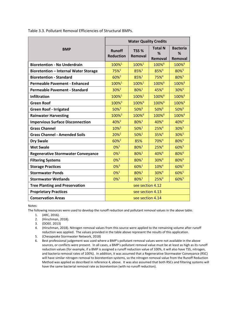
Table 3.3. Pollutant Removal Efficiencies of Structural BMPs.
BMP
Water Quality Credits
Runoff Reduction
TSS % Removal
Total N %
Removal
Bacteria %
Removal
Bioretention - No Underdrain 100%1 100%1 100%6 100%6
Bioretention – Internal Water Storage 75%1 85%1 85%4 80%5
Bioretention - Standard 60%2 85%1 75%4 80%5
Permeable Pavement - Enhanced 100%1 100%1 100%6 100%6
Permeable Pavement - Standard 30%2 80%1 45%4 30%6
Infiltration 100%1 100%1 100%6 100%6
Green Roof 100%3 100%6 100%6 100%6
Green Roof - Irrigated 50%3 50%6 50%6 50%6
Rainwater Harvesting 100%3 100%6 100%6 100%6
Impervious Surface Disconnection 40%2 80%1 40%4 40%6
Grass Channel 10%2 50%1 25%4 30%5
Grass Channel - Amended Soils 20%2 50%1 35%4 30%5
Dry Swale 60%2 85% 70%4 80%5
Wet Swale 0%1 80%1 25%4 60%5
Regenerative Stormwater Conveyance 0%1 80%1 40%6 80%6
Filtering Systems 0%3 80%1 30%4 80%6
Storage Practices 0%3 60%1 10%4 60%5
Stormwater Ponds 0%1 80%1 30%4 60%5
Stormwater Wetlands 0%1 80%1 25%4 60%5
Tree Planting and Preservation see section 4.12
Proprietary Practices see section 4.13
Conservation Areas see section 4.14
Notes:
The following resources were used to develop the runoff reduction and pollutant removal values in the above table.
1. (ARC, 2016). 2. (Hirschman, 2018). 3. (DOEE. 2013) 4. (Hirschman, 2018). Nitrogen removal values from this source were applied to the remaining volume after runoff
reduction was applied. The values provided in the table above represent the results of this application. 5. (Chesapeake Stormwater Network, 2018) 6. Best professional judgement was used where a BMP’s pollutant removal values were not available in the above
sources, or conflicts were present. In all cases, a BMP’s pollutant removal value must be at least as high as its runoff reduction values (for example, if a BMP is assigned a runoff reduction value of 100%, it will also have TSS, nitrogen, and bacteria removal rates of 100%). In addition, it was assumed that a Regenerative Stormwater Conveyance (RSC) will have similar nitrogen removal to bioretention systems, so the nitrogen removal value from the Runoff Reduction Method was applied as described in reference 4, above. It was also assumed that both RSCs and filtering systems will have the same bacterial removal rate as bioretention (with no runoff reduction).
3.6 Erosion & Sediment Control (ESC) Requirements The design and management of construction site runoff control measures for all qualifying
developments as defined in the Ordinance shall be in accordance with SCDHEC NPDES General Permit
for Stormwater Discharges from Construction Activities, the SCDHEC Erosion and Sediment Reduction
and Stormwater Management regulations and its most current version of standards, where applicable.
The Town of Bluffton reserves the right to require additional erosion and sediment control or a higher
standard of measure and make their requirement a condition of a development permit approval.
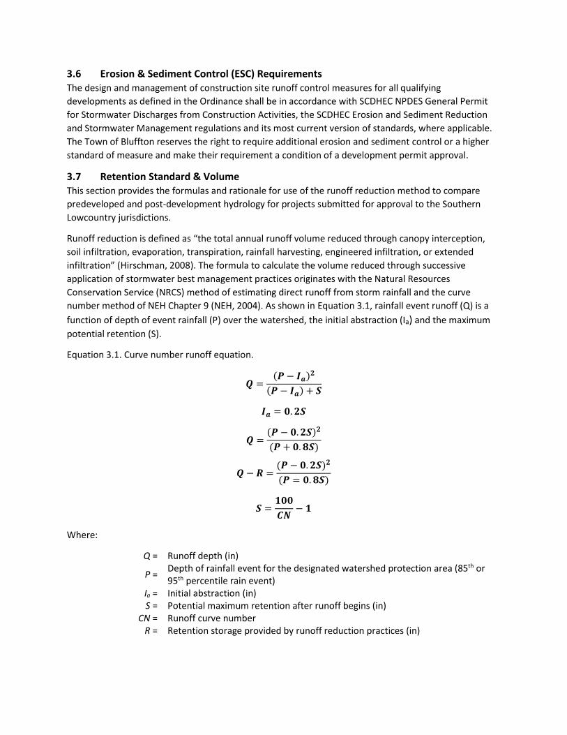
3.7 Retention Standard & Volume This section provides the formulas and rationale for use of the runoff reduction method to compare
predeveloped and post-development hydrology for projects submitted for approval to the Southern
Lowcountry jurisdictions.
Runoff reduction is defined as “the total annual runoff volume reduced through canopy interception,
soil infiltration, evaporation, transpiration, rainfall harvesting, engineered infiltration, or extended
infiltration” (Hirschman, 2008). The formula to calculate the volume reduced through successive
application of stormwater best management practices originates with the Natural Resources
Conservation Service (NRCS) method of estimating direct runoff from storm rainfall and the curve
number method of NEH Chapter 9 (NEH, 2004). As shown in Equation 3.1, rainfall event runoff (Q) is a
function of depth of event rainfall (P) over the watershed, the initial abstraction (Ia) and the maximum
potential retention (S).
Equation 3.1. Curve number runoff equation.
𝑸 =(𝑷 − 𝑰𝒂)
𝟐
(𝑷 − 𝑰𝒂) + 𝑺
𝑰𝒂 = 𝟎. 𝟐𝑺
𝑸 =(𝑷 − 𝟎. 𝟐𝑺)𝟐
(𝑷 + 𝟎. 𝟖𝑺)
𝑸 − 𝑹 =(𝑷 − 𝟎. 𝟐𝑺)𝟐
(𝑷 = 𝟎. 𝟖𝑺)
𝑺 =𝟏𝟎𝟎
𝑪𝑵− 𝟏
Where:
Q = Runoff depth (in)
P = Depth of rainfall event for the designated watershed protection area (85th or 95th percentile rain event)
Ia = Initial abstraction (in) S = Potential maximum retention after runoff begins (in)
CN = Runoff curve number R = Retention storage provided by runoff reduction practices (in)
Not all stormwater BMPs provide runoff reduction equally. Through the crediting procedures of the
Compliance Calculator found in Appendix H and the retention volumes required in this section,
designers will be able to evaluate their proposed designs and submit for approval in a unified process
across the Southern Lowcountry jurisdictions.1
Supplemental information on the terms below can be found in the Low Impact Development in Coastal
South Carolina: Planning and Design Guide, and the Georgia Stormwater Management Manual (Ellis, K.
et al., 2014; ARC, 2016).
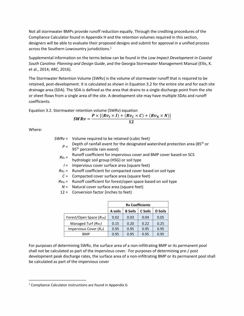
The Stormwater Retention Volume (SWRv) is the volume of stormwater runoff that is required to be
retained, post-development. It is calculated as shown in Equation 3.2 for the entire site and for each site
drainage area (SDA). The SDA is defined as the area that drains to a single discharge point from the site
or sheet flows from a single area of the site. A development site may have multiple SDAs and runoff
coefficients.
Equation 3.2. Stormwater retention volume (SWRv) equation
𝑺𝑾𝑹𝒗 =𝑷 × [(𝑹𝒗𝑰 × 𝑰) + (𝑹𝒗𝑪 × 𝑪) + (𝑹𝒗𝑵 ×𝑵)]
𝟏𝟐
Where:
SWRv = Volume required to be retained (cubic feet)
P = Depth of rainfall event for the designated watershed protection area (85th or 95th percentile rain event)
RvI = Runoff coefficient for impervious cover and BMP cover based on SCS hydrologic soil group (HSG) or soil type
I = Impervious cover surface area (square feet) RvC = Runoff coefficient for compacted cover based on soil type
C = Compacted cover surface area (square feet) RvN = Runoff coefficient for forest/open space based on soil type
N = Natural cover surface area (square feet) 12 = Conversion factor (inches to feet)
Rv Coefficients
A soils B Soils C Soils D Soils
Forest/Open Space (RVN) 0.02 0.03 0.04 0.05
Managed Turf (RvC) 0.15 0.20 0.22 0.25
Impervious Cover (RvI) 0.95 0.95 0.95 0.95
BMP 0.95 0.95 0.95 0.95
For purposes of determining SWRv, the surface area of a non-infiltrating BMP or its permanent pool shall not be calculated as part of the impervious cover. For purposes of determining pre-/ post development peak discharge rates, the surface area of a non-infiltrating BMP or its permanent pool shall be calculated as part of the impervious cover
1 Compliance Calculator instructions are found in Appendix G
The Compliance Calculator in Appendix H uses best available pollutant removal efficiencies for total suspended solids, total nitrogen and fecal indicator bacteria. Use of the compliance calculator allows the designer to evaluate alternative designs to arrive at compliance with the runoff reduction and pollutant removal requirements and clearly summarize them for the Town of Bluffton plan reviewer. The compliance calculator output is a necessary submittal for a plan reviewer to evaluate selected BMPs to demonstrate compliance with the watershed protection area standards of this Manual.
3.7.1 Total Suspended Solids, Nutrients, & Bacteria
The minimum pollutant removal performance requirements for all watersheds of the Southern
Lowcountry include the interception and treatment of stormwater runoff volume to at least an 80%
reduction in total suspended solids load, 30% reduction of total nitrogen load, and 60% reduction in
bacteria load. These requirements are established for the following reasons.
Stormwater in the Lowcountry conveys the plant nutrients nitrogen and phosphorus. Nitrogen tends to
dissolve in water, but phosphorus is adsorbed to suspended solids predominantly. Control of total
suspended solids through the BMPs in this Manual will also remove a proportional amount of
phosphorus. Relying on the judgement of stormwater researchers and other state design manuals, the
approach for the Southern Lowcountry is similar. If a BMP is effective at runoff reduction or retention of
stormwater, it is similarly effective at removal of the initial volume of suspended solids (NCDEQ, 2014).
Many of the Southern Lowcountry watersheds at the HUC-12 size are directly tributary to bacteria and
shellfish impaired waters. As these watersheds develop with rooftops, roads and other impervious
surfaces, there is an increasing potential for bacteria in the stormwater from wildlife populations (deer,
racoons, waterfowl), pet waste, septic system discharges and sanitary sewer system malfunctions.
Similarly, nutrients can be expected to increase due to fertilizer use in erosion control practices,
managed turf and landscaping, septic system leachate, and atmospheric deposition on impervious
surfaces. Best management practices, along with better site design practices, can be used to reduce
bacteria and nutrients in stormwater to the benefit and restoration of Southern Lowcountry water
quality.
3.7.2 Hydrologic & Hydraulic Analysis
In order to prevent an increase in the duration, frequency and magnitude of downstream overbank
flooding and scouring, this Manual requires that enough stormwater detention be provided on a
development site to control the post-development peak runoff discharge to the predevelopment runoff
rates for the 2, 10, 25, 50 and 100 -year, 24-hour storm events. The capacity of the existing downstream
receiving conveyance system for all off-site discharge points must be determined to be adequate. An
analysis of the downstream conveyance capacity to accommodate the site’s post development 25- and
100-year, 24-hour peak flow shall be provided in the engineering report. Discharge to the public right-of-
way of the SC State highway system shall comply with the SCDOT Requirements for Hydraulic Design
Studies. Necessary upgrades within the public right-of-way due to inadequate capacity for the post-
development 25-yr flow must be identified during the permit application process. Upgrades to the
downstream system to accommodate the 100-yr 24-hour flow must be considered through the MEP
process outlined in Section 3.9. Documentation supporting safe passage of the 100-yr post development
flow to the downstream point where the detention or storage area comprises 10% of the total drainage
area, and an analysis of the surrounding neighborhood area to identify any existing capacity shortfalls or
drainage blockages is required for plan approval. This analysis is called the 10% analysis rule in Section
3.8 of this Manual.
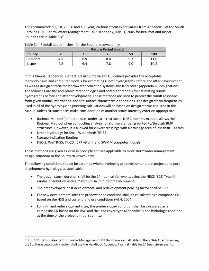
The recommended 2, 10, 25, 50 and 100-year, 24-hour storm event values from Appendix F of the South
Carolina DHEC Storm Water Management BMP Handbook, July 31, 2005 for Beaufort and Jasper
Counties are in Table 3.42.
Table 3.4. Rainfall depth (inches) for the Southern Lowcountry.
Return Period (years)
County 2 10 25 50 100
Beaufort 4.5 6.9 8.4 9.7 11.0
Jasper 4.2 6.4 7.8 9.0 10.2
In this Manual, Appendix I General Design Criteria and Guidelines provides the acceptable
methodologies and computer models for estimating runoff hydrographs before and after development,
as well as design criteria for stormwater collection systems and land cover (Appendix R) designations.
The following are the acceptable methodologies and computer models for estimating runoff
hydrographs before and after development. These methods are used to predict the runoff response
from given rainfall information and site surface characteristic conditions. The design storm frequencies
used in all of the hydrologic engineering calculations will be based on design storms required in this
Manual unless circumstances make consideration of another storm intensity criterion appropriate:
• Rational Method (limited to sites under 10 acres) Note: DHEC, nor this manual, allows the Rational Method when conducting analysis for stormwater being routed to/through BMP structures. However, it is allowed for culvert crossings with a drainage area of less than 10 acres.
• Urban Hydrology for Small Watersheds TR-55
• Storage-Indication Routing
• HEC-1, WinTR-55, TR-20, ICPR v3 or 4 and SWMM computer models
These methods are given as valid in principle and are applicable to most stormwater management
design situations in the Southern Lowcountry.
The following conditions should be assumed when developing predevelopment, pre-project, and post-
development hydrology, as applicable:
• The design storm duration shall be the 24-hour rainfall event, using the NRCS (SCS) Type III rainfall distribution with a maximum six-minute time increment.
• The predeveloped, post development, and redevelopment peaking factor shall be 323.
• For new development sites the predeveloped condition shall be calculated as a composite CN based on the HSG and current land use conditions (NEH, 2004).
• For infill and redevelopment sites, the predeveloped condition shall be calculated as a composite CN based on the HSG and the land cover type (Appendix R) and hydrologic condition at the time of the project’s initial submittal.
2 Until SCDHEC updates its Stormwater Management BMP Handbook rainfall table to the NOAA Atlas 14 values, the Southern Lowcountry region shall use the Handbook Appendix F rainfall table for 24 hour storm events.
• Antecedent Runoff Condition (ARC) II is the average adjustment factor for calculations using TR-55. ARC III is to be used for wetter conditions such as areas that receive irrigation water harvested from stormwater ponds and for poorly drained soils.
Project designs must include supporting data and source information. All storm sewer systems shall be
analyzed for both inlet and outlet control (including tailwater effects) by using the following:
a. Equations and nomographs as shown in the Federal Highway Administration (FHWA)
Hydraulic Design Services (HDS) publication No. 5.
b. Computer programs that calculate the actual hydraulic grade line for the storm sewer system
can be used, provided all losses (friction, bend, junction, etc.) are taken into account using the
appropriate loss coefficient (K) values.
c. Design tailwater condition elevation shall be supported by a reasonable resource and/or
analysis.
d. Allowable headwater. The allowable headwater of all culverts, pipe systems, open channels,
bridges and roadway culverts shall be established following the SCDOT Requirements for
Hydraulic Design Studies.
All culverts, pipe systems, and open channel flow systems shall be sized in accordance with the design
criteria found in Appendix I Hydrology and Hydraulics Design Requirements.
3.7.3 Maintenance Easements
Maintenance easements are provided for the protection and legal maintenance of stormwater
management facilities not within a right-of-way. Drainage easements shall be required in subdivisions
over any portion of a stormwater management facilities not within a right-of-way and necessary for the
functioning of the system. Drainage easements for all facilities must be shown on construction drawings
and approved by the stormwater manager. The easements shall be designated on the plan prior to
issuance of a development permit and recorded in public records with copy of recorded easement
submitted prior to Town of Bluffton permit termination. The minimum allowable width of drainage
easements shall be as shown in Table 3.5.
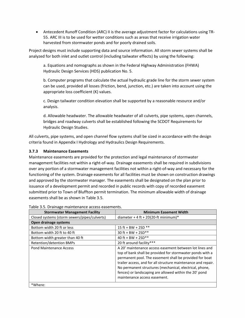
Table 3.5. Drainage maintenance access easements. Stormwater Management Facility Minimum Easement Width
Closed systems (storm sewers/pipes/culverts) diameter + 4 ft + 2D(20-ft minimum)*
Open drainage systems
Bottom width 20 ft or less 15 ft + BW + 2SD **
Bottom width 20 ft to 40 ft 30 ft + BW + 2SD**
Bottom width greater than 40 ft 40 ft + BW + 2SD**
Retention/detention BMPs 20 ft around facility***
Pond Maintenance Access A 20’ maintenance access easement between lot lines and top of bank shall be provided for stormwater ponds with a permanent pool. The easement shall be provided for boat trailer access, and for all structure maintenance and repair. No permanent structures (mechanical, electrical, phone, fences) or landscaping are allowed within the 20’ pond maintenance access easement.
*Where:
D = Depth from grade to pipe invert **Where: BW = Bottom width S = Side slope D = Depth of opening
Note: The minimum required width and configuration of drainage easements may be modified if deemed necessary by the stormwater manager for justifiable reasons.
3.8 Extreme Flood Requirement: 10% Rule
The peak discharge generated by the 100-year, 24-hour storm event under post-development
conditions is considered the extreme peak discharge. The intent of the extreme flood protection is to
prevent flood damage from infrequent but large storm events, maintain the boundaries of the mapped
100-year floodplain, and protect the physical integrity of the best management practices as well as
downstream stormwater and flood control facilities. The 100-yr flow is to be used in the routing of
runoff through the drainage system and stormwater management facilities to determine the effects on
the facilities, adjacent property, and downstream. Emergency spillways of best management practices
should be designed appropriately to pass the resulting flows safely.
Documentation supporting safe passage of the 100-year post-development flow shall be provided by the
applicant/engineer. In order to prevent an increase in the duration, frequency and magnitude of
downstream extreme flooding over existing conditions, an evaluation must be provided to include
downstream analysis to the point where the project comprises 10% of the total contributing drainage
area. The 10% rule evaluation must address existing conveyance system capacity and “pinch points”
where a pipe/culvert would be overtopped and where the pipe/culvert will need to be upgraded or the
peak discharge rate will need to be limited to the capacity of the downstream system.
The 10% rule recognizes the fact that a structural BMP control providing detention has a “zone of
influence” downstream where its effectiveness can be felt. Beyond this zone of influence, the structural
control becomes relatively small and insignificant compared to the runoff from the total drainage area
at that point. Based on studies and master planning results from a large number of sites, that zone of
influence is considered to be the point where the drainage area controlled by the detention or storage
facility comprises 10% of the total drainage area. For example, if the drainage control drains 10 acres,
the zone of influence ends at a point where the total drainage area is 100 acres or greater (ARC, 2016).
Demonstration of safe passage of the 100-year, 24-hour storm shall include a stage storage analysis of
the system, an inflow/outflow comparison of the system, and construction of a table showing peak
stage elevations in comparison to safe freeboards to structures of the system and adjacent
buildings/structures/infrastructure. Safe passage to the receiving water also requires that there be no
additional downstream flooding or other environmental impacts (e.g., stream channel enlargement,
degradation of habitat).
Typical steps in the application of the 10% rule are:
1. Determine the target peak flow for the site for predevelopment conditions.
2. Using a topographic map, determine the lower limit of the zone of influence (10% point)
3. Using a hydrologic model, determine the predevelopment peak flows and timing of those peaks
at each tributary junction beginning at the pond outlet and ending at the next tributary junction
beyond the 10% point.
4. Change land use on the site to post-development and rerun the model.
5. Design the structural control facility such that the overbank flood protection (25-year) post-
development flow is adequately conveyed to the lower limit of the zone of influence and the
Extreme Flood (100-year) post-development flow does not impact any existing structures within
the area of zone of influence.
6. If the overbank flood protection (25-year) post-development flow is not adequately conveyed to
the lower limit of the zone of influence and/or Extreme Flood (100-year) post-development flow
is shown to impact any structure, the structural control facility must be redesigned or one of the
following options considered:
a. Work with the Town of Bluffton to reduce the flow elevation through channel or flow
conveyance structure improvements downstream.
b. Obtain a flow easement from downstream property owners to the 10% point.
c. Request a detention waiver from Town of Bluffton. This waiver would be for water
quantity control only and best management practices to achieve water quality goals will
still be required.
3.9 Maximum Extent Practicable Maximum extent practicable (MEP) is the language of the Clean Water Act that sets the standards to
evaluate efforts pursued to achieve pollution reduction to the Waters of the United States. The MEP
refers to management practices; control techniques; and system, design, and engineering methods for
the control of pollutants. It allows for considerations of public health risks, societal concerns, and social
benefits, along with the gravity of the problem and the technical feasibility of solutions. The MEP for
stormwater management is achieved, in part, through a process of selecting and implementing different
design options with various structural and non-structural stormwater best management practices
(BMPs), where ineffective BMP options may be rejected, and replaced when more effective BMP
options are found (DOEE, 2019).
The Owner/Applicant must be aware that the first priority for the proposed development is to meet the
required stormwater retention volume (SWRv) and peak flow requirements according to the Southern
Lowcountry Stormwater Design Manual. Meeting the SWRv and peak flow requirements is attainable on
any site depending on a number of factors including percent of proposed impervious area and green
space conserved and/or provided. The proposed development site may have constraints or limitations
that prevent Design Manual requirements from being met. It is for these projects that the MEP
evaluation and waiver consideration will be required. Several site and stormwater design iterations may
be necessary to ensure that Maximum Extent Practicable is achieved.
Through application of stormwater best management practices on site and/or at an off-site property
within the same stormwater drainage catchment, land development projects should be able to comply
with the Southern Lowcountry Stormwater Design Manual. It is the applicant’s responsibility to
demonstrate to the greatest extent that the requirements of this Manual can be met for the proposed
development. The applicant must fully demonstrate that the requirements of the Manual are not
possible or feasible before entering into a MEP analysis, and only after the concurrence of the Town of
Bluffton based on the project submittals, documentation and discussions. The Owner/applicant must
realize that if the requirements of the Manual cannot be met, the site may not be conducive for
development, as proposed, in the interest of public safety and welfare.
This evaluation is intended to be evaluated, considered and presented during the concept review stage
of the Stormwater Management Plan for the proposed development.
1) Present a SWMP for the proposed development that meets stormwater retention volume (SWRv), and peak flow requirements for channel and extreme flood protection for the proposed development and identify the reasons that this plan can not be implemented.
2) Demonstrate why SWRv cannot be achieved by a reduction of impervious and disturbed area and/or increase in green space area on site.
3) Demonstrate how Better Site Design (BSD) has been. implemented to the maximum extent practicable or document site restrictions that prevent BSD application.
a. What efforts have been made to reduce impervious cover in the project limits of disturbance?
b. Are natural assets protected or conserved? c. Is stream restoration considered? d. Are structural and non-structural BMPs used in this project?
4) List site restrictions that prevent or otherwise limit effective use of stormwater BMPs. 5) Provide SWrv and Pollutant Load reductions for alternatives analyzed as compared to pollutant
load reductions for full SWRv. 6) What site limitations prevent retention of the SWRv or meeting the required peak discharge
limits? 7) Is there off-site opportunity and capacity in the same drainage catchment to meet the
volume/peak flow and/or Swrv requirements for the site’s contributing drainage area(s)? 8) Does the publicly maintained stormwater drainage system have sufficient capacity for the
development site’s extreme flood peak flow? 9) Develop a cost versus aggregated stormwater retention volume achieved curve for the site’s
contributing drainage area (e.g. cost vs. % SWRv met). A minimum of five cost points with various BMP iterations/%SWrv met are necessary for the curve. One of the cost points shall be for 100% of the SWRv. If it’s available, off-site capacity cost may be included in your evaluation. Identify the inflection point of the cost curve to select the optimal solution where increased cost does not result in increased effectiveness. What is the projected cost to meet the SWRv with filtering BMPs with underdrains and green roofs? What alternatives have been considered to reduce impervious and disturbed area and/or increase green space area on site.
10) The optimum aggregated retention value and BMP selection and size analysis must be submitted as a part of the stormwater management plan for the project.
11) Offsite stormwater volume retention credit or fee-in-lieu documents will be required for project completion.
The MEP submittal must provide documentable evidence of the process the applicant has performed
that demonstrates the restrictions to the use and implementation of BMPs to meet the requirements of
this Manual in whole or in part.
3.10 Off-Site Stormwater Management
All stormwater management design plans shall include on-site stormwater management practices,
unless post-construction stormwater runoff in an off-site or regional stormwater management practice
is approved according to this Section.
The off-site or regional stormwater management practice must be located on property legally dedicated
to that purpose, be designed and sized to meet the post-construction stormwater management criteria
presented in this Manual, provide a level of stormwater quality and quantity control that is equal to or
greater than that which would be provided by on-site green infrastructure and stormwater management
practices, be in the same drainage catchment, as defined by the Town of Bluffton, as the project area,
and have an associated inspection and maintenance agreement and plan. In addition, appropriate
stormwater management practices shall be installed, where necessary, to protect properties and
drainage channels that are located between the development site and the location of the off-site or
regional stormwater management practice.
To be eligible for compliance through the use of off-site stormwater management practices, the
applicant must submit a stormwater management design plan to the Town of Bluffton that
demonstrates the adequacy of the off-site or regional stormwater management practice, and
demonstrates, to the satisfaction of the Town of Bluffton that the off-site or regional stormwater
management practice will not result in any of the following impacts:
(1) Increased threat of flood damage or endangerment to public health or safety;
(2) Deterioration of existing culverts, bridges, dams, and other structures;
(3) Accelerated streambank or streambed erosion or siltation;
(4) Degradation of in-stream biological functions or habitat; or,
(5) Water quality impairment in violation of state water quality standards and/or violation of
any other state or federal regulations.
Upon approval of off-site stormwater management practices, the Owner/applicant shall prepare final
design plans for the facility construction and secure all easements, maintenance agreements, permits as
required to facilitate its construction. Plan approval for the of off-site stormwater management facility
will be tied to the Development Plan approval/permit and its requirements and must be completed and
approved according to the time frame/phasing plan of the Development Plan approval/permit.
3.11 Fee-in-Lieu Fee-in-lieu is, as the name suggests, a program where an entity with the responsibility of managing
stormwater runoff pays a fee in lieu of physically managing and maintaining stormwater on site or off
site. Based on the cost of treatment, long term maintenance/repair/replacement and inspection costs, a
representative cost of treating stormwater can be established, and that money can go to larger scale
and more efficient practices being implemented (ARC, 2016). The developer provides a fee to the Town
of Bluffton (or its assigned entity) that will help cover cost of installation and long-term operation and
maintenance of the stormwater practice. A fee-in-lieu program can be administered through the Town
of Bluffton a public/private initiative, or a private bank. Any fee-in-lieu program must have an Enterprise
Fund and ability to oversee construction activities (e.g. programs managed by the Town of Bluffton) or
be able to collect fees and dedicate those funds to stormwater related projects. In-lieu fees typically
need to cover higher municipal prevailing wage and public bidding costs. The off-site mitigation
practices must be implemented in the same HUC-12 watershed as the original project (or more
restrictive limits, at the discretion of the Town of Bluffton). Therefore, careful accounting must take
place to ensure that each site using off-site mitigation to meet pollutant removal requirements has
corresponding off-site controls in the same watershed (CWP, 2012).
3.12 Waivers Individuals seeking a waiver from the requirements of the Town of Bluffton UDO and this Design Manual may submit to the Town of Bluffton UDO Administrator a request for a waiver in accordance with the Southern Lowcountry Stormwater Design Manual.
(1) Request of a Waiver at Staff Level A written request for a waiver is required and shall state the specific waiver sought and the reasons, with supporting data, a waiver should be granted. The request shall include all information necessary to evaluate the proposed waiver. Requests must outline the need for such a waiver. Cost shall not be considered cause for a waiver. The applicant will address the criteria below for consideration of a waiver approval:
a. What exceptional circumstances to the site are evident that on-site or off-site stormwater management requirements cannot be met?
b. What unnecessary hardship is being caused?
c. How will denial of the waiver be inconsistent with the intent of the Ordinance?
d. How will granting the waiver comply with the intent of the Ordinance?
e. How are state and federal regulations still being met?
(2) Review of Waivers The Town of Bluffton UDO Administrator will conduct a review of the request and will issue a decision within thirty (30) working days of receiving the request.
(3) Fee-in-Lieu Requirement a. If a Waiver is granted, the applicant must submit a fee in lieu of meeting stormwater
requirements as determined by Town of Bluffton for regional stormwater management projects.
(4) Appeal of Decision Any person aggrieved by the decision of the UDO Administrator concerning a waiver request may appeal such decision in accordance with the Town of Bluffton established process.
3.13 References Atlanta Regional Commission (ARC). 2016. Georgia Stormwater Management Manual. Atlanta Regional
Commission (ARC), Atlanta, Georgia.
Blair, A., et. al. 2012. Quantifying and Simulating Stormwater Runoff in Watersheds. Hydrological
Processes. 28, 559–569.
Chesapeake Stormwater Network (CSN). 2018. Fecal Indicator Bacteria Management Reviewing the
Latest Science on Bacteria Control for Watershed Managers. Retrieved from:
https://chesapeakestormwater.net/2018/10/fecal-indicator-bacteria-management/
Center for Watershed Protection, Inc. (CWP). 2012. Guidance for Developing an Off-site stormwater Compliance Program in West Virginia. Retrieved from: https://owl.cwp.org/mdocs-posts/cwp-2012-guidance-developing-off-site-sw-program/
District of Columbia, Department of Energy and Environment (DC DOEE). 2019. Stormwater Management Guidebook. Retrieved from: https://doee.dc.gov/node/1386211
Ellis, K., Berg, C., Caraco, D., Drescher, S., Hoffmann, G., Keppler, B., LaRocco, M., & A. Turner. 2014. Low Impact Development in Coastal South Carolina: A Planning and Design Guide. ACE Basin and North Inlet – Winyah Bay National Estuarine Research Reserves.
Hirschman, D., Collins, K., & T. Schueler. 2008. Technical Memorandum: The Runoff Reduction Method.
Center for Watershed Protection, Inc. (CWP).
Hirschman, D. L. 2018. Updating the Runoff Reduction Method. Metro Government of Nashville and
Davidson County, Tennessee. Retrieved from: https://hirschmanwater.com/projects/
Jasper County, SC. (October 2011). Stormwater Management Design Manual.
North Carolina Department of Environmental Quality (NCDEQ). 2017. Stormwater Design Manual.
Retrieved from: https://deq.nc.gov/sw-bmp-manual
United States Department of Agriculture (USDA) Natural Resource Conservation Service (NRCS). 2004.
National Engineering Handbook (NEH) Chapter 10, Part 630. Washington, D.C.: USDA Natural
Resources Conservation Service. Retrieved from:
https://www.nrcs.usda.gov/wps/portal/nrcs/detailfull/national/water/?&cid=stelprdb1043063
National Pollutant Discharge Elimination System (NPDES) Municipal Separate Storm Sewer System (MS4)
General Permit Remand. Environmental Protection Agency (EPA), 81 Fed. Reg. 3 (Jan 6, 2016).
Federal Register: The Daily Journal of the United States, p. 415–435. Codified at 40 C.F.R. pt.
122.