Embed Size (px)
Citation preview
land use and
tRanspoRtationThe Land Use and Transportation chapter contains information on the following topics:
n Land use — information on land use categories and the general plan land use map, with discussion and policies relating to future land use development.
n Transportation — goals and policies related to transportation improvements.
n Economy — information on current economic conditions and discussion and policies relating to future trends and challenges.
n Open space — information on open space areas, service needs and future policies to meet demand for open space.
chapteR 3


land uSe
Land use has an effect on virtually all other elements of the General Plan. Land use determines the character of the community, its economic vitality and future demand for services. Therefore, it is essential to have a firm base from which to identify and consider land use issues. While providing this information, the General Plan also articulates the community’s vision for the future through a description of goals, policies and actions. Since the first General Plan was adopted for Sunnyvale in 1957, the City has expressed its goals for the future with emphasis in four broad areas:
n Appropriate housing
n Strong economy
n Transportation efficiency
n Community character
These areas are comprehensive and interwoven concepts. They have a timeless quality and continue to provide a solid platform for the City’s land use and transportation goals.
The Land Use and Transportation Element sections will be updated in 2012. Thegoals and policies of this element and other policies relating to a strong economy and communitycharacterarebeingreviewedaspartofthatupdate.UsersofthisGeneralPlanshouldconsultthefulltextoftheLandUseandTransportationElementforthedata and analysis, as well as action programs and other information. The goals and policies and a summary of the discussion are below.
Goal lt-1 Coordinated reGional planninG
PRoTeCT And SuSTAin A high QuAliTY oF liFe in SunnYvAle bY PARTiCiPATing
in CooRdinATed lAnd uSe And TRAnSPoRTATion PlAnning in The Region.
(Previously LUTE Goal R1 / Adopted in 1997)
policy lt-1.1 AdvoCATe The CiTY’S inTeReSTS To RegionAl AgenCieS ThAT MAke lAnd uSe And TRAnSPoRTATion SYSTeM deCiSionS ThAT AFFeCT SunnYvAle. (Previously LUTE Policy R1.1)
the full text of the land use and transportation element is available at GeneralPlan.inSunnyvale.com
3–3
l and use and tRanspoRtation — l and use Chapter 3
policy lt-1.2 SuPPoRT CooRdinATed RegionAl TRAnSPoRTATion SYSTeM PlAnning And iMPRoveMenTS. (Previously LUTE Policy R1.2)
policy lt-1.3 PRoMoTe inTegRATed And CooRdinATed loCAl lAnd uSe And TRAnSPoRTATion PlAnning. (Previously LUTE Policy R1.3)
n LT-1.3a Participate in intergovernmental activities related to regional and sub-regional land use and transportation planning in order to advance the City’s interests. (Previously LUTE Action Strategy R1.3.1)
n LT-1.3b Promote shorter commute trips and ease congestion by advocating that all communities provide housing and employment opportunities. (Previously LUTE Action Strategy R1.3.2)
n LT-1.3c Monitor significant land use and transportation decisions pending in other communities to ensure that Sunnyvale is not adversely affected. (Previously LUTE Action Strategy R1.3.3)
policy lt-1.4 AChieve An oPeRATing level oF SeRviCe (loS) “e” oR beTTeR FoR All RegionAl RoAdwAYS And inTeRSeCTionS, AS deFined bY The CiTY FunCTionAl ClASSiFiCATion oF The STReeT SYSTeM. (Previously LUTE Policy R1.4)
policy lt-1.5 MAinTAin A FunCTionAl ClASSiFiCATion oF The STReeT SYSTeM ThAT idenTiFieS CongeSTion MAnAgeMenT PRogRAM RoAdwAYS And inTeRSeCTionS, AS well AS loCAl RoAdwAYS And inTeRSeCTionS oF RegionAl SigniFiCAnCe. (Previously LUTE Policy R1.5)
policy lt-1.6 PReSeRve The oPTion oF exTending MARY Avenue To The induSTRiAl AReAS noRTh oF u.S. highwAY 101. (Previously LUTE Policy R1.6)
City of Sunnyvale GeneRal pl an – July 2011
3–4

policy lt-1.7 ConTRibuTe To eFFoRTS To MiniMize Region-wide AveRAge TRiP lengTh And Single-oCCuPAnT vehiCle TRiPS. (Previously LUTE Policy R1.7)
n LT-1.7a Locate higher intensity land uses and developments so that they have easy access to transit services. (Previously LUTE Action Strategy R1.7.1)
n LT-1.7b Support regional efforts which promote higher densities near major transit and travel facilities, without increasing the overall density of land usage. (Previously LUTE Action Strategy R1.7.2)
n LT-1.7c Cooperate in efforts to study demand management initiatives including congestion-pricing, flexible schedules, gas taxes and market-based programs. (Previously LUTE Action Strategy R1.7.3)
policy lt-1.8 SuPPoRT STATewide, RegionAl And Sub-RegionAl eFFoRTS ThAT PRovide FoR An eFFeCTive TRAnSPoRTATion SYSTeM. (Previously LUTE Policy R1.8)
n LT-1.8a Endorse funding to provide transportation system improvements that facilitate regional and interregional travel. (Previously LUTE Action Strategy R1.8.1)
n LT-1.8b Advocate the preservation of railroad lines for both commuter and freight transit. (Previously LUTE Action Strategy R1.8.2)
n LT-1.8c Advocate improvements to state and county roadways serving Sunnyvale. (Previously LUTE Action Strategy R1.8.3)
n LT-1.8d Support efforts to plan and implement effective inter-jurisdictional transportation facilities. (Previously LUTE Action Strategy R1.8.4)
policy lt-1.9 SuPPoRT Flexible And APPRoPRiATe AlTeRnATive TRAnSPoRTATion ModeS And TRAnSPoRTATion SYSTeM MAnAgeMenT MeASuReS ThAT ReduCe ReliAnCe on The AuToMobile And SeRve ChAnging RegionAl And CiTYwide lAnd uSe And TRAnSPoRTATion needS. (Previously LUTE Policy R1.9)
3–5
l and use and tRanspoRtation — l and use Chapter 3

n LT-1.9a Support state and regional efforts to provide High Occupant Vehicle (HOV) lanes, ridesharing, mass transit service, bicycling and Intelligent Transportation Systems. (Previously LUTE Action Strategy R1.9.1)
n LT-1.9b Promote modes of travel and actions that reduce single-occupant vehicle trips and trip lengths. (Previously LUTE Action Strategy R1.9.2)
policy lt-1.10 SuPPoRT lAnd uSe PlAnning ThAT CoMPleMenTS The RegionAl TRAnSPoRTATion SYSTeM. (Previously LUTE Policy R1.10)
n LT-1.10a Encourage a variety of land use types and intensities on a regional level while maintaining and improving regional transportation service levels. (Previously LUTE Action Strategy R1.10.1)
n LT-1.10b Support alternative transportation services, such as light rail, buses and commuter rail, through appropriate land use planning. (Previously LUTE Action Strategy R1.10.2)
n LT-1.10c Encourage mixed uses near transit centers. (Previously LUTE Action Strategy R1.10.3)
policy lt-1.11 PRoTeCT RegionAl enviRonMenTAl ReSouRCeS ThRough loCAl lAnd uSe PRACTiCeS. (Previously LUTE Policy R1.11)
n LT-1.11a Participate in state and regional activities to protect the natural environment. (Previously LUTE Action Strategy R1.11.1)
n LT-1.11b Protect and preserve the diked wetland areas in the Baylands, which serve as either salt evaporation ponds or holding ponds for the wastewater treatment plant. (Previously LUTE Action Strategy R1.11.2)
See Goal em-11 (improved air Quality) for further discussion and policies relating to proximity of housing and jobs.
City of Sunnyvale GeneRal pl an – July 2011
3–6

policy lt-1.12 PRoTeCT The QuAliTY oF liFe FoR ReSidenTS And buSineSSeS in SunnYvAle bY ACTivelY PARTiCiPATing in diSCuSSionS And deCiSionS on PoTenTiAl uSeS oF MoFFeTT FedeRAl AiRField. (Previously LUTE Policy R1.12)
n LT-1.12a Comprehensively review any proposed aviation services at Moffett that could increase aviation activity or noise exposure. (Previously LUTE Action Strategy R1.12.1)
n LT-1.12b Encourage appropriate uses that best support business and residents’ desire in Sunnyvale. (Previously LUTE Action Strategy R1.12.2)
n LT-1.12c Pursue annexation of that portion of Moffett Federal Airfield within Sunnyvale’s sphere of influence. (Previously LUTE Action Strategy R1.12.3)
Goal lt-2 an attraCtive CoMMunity
PReSeRve And enhAnCe An ATTRACTive CoMMuniTY, wiTh A PoSiTive iMAge
And A SenSe oF PlACe ThAT ConSiSTS oF diSTinCTive neighboRhoodS,
PoCkeTS oF inTeReST And huMAn-SCAle develoPMenT. (Previously LUTE Goal C1 / Adopted in 1997)
figure 3-1: General Plan and Zoning Districts
General Plan Category Zoning Districts
Residential
Rlo — Residential low density (0-7 dwelling units/acre)
(R-0 and R-1) low density Residential
RlM — Residential low Medium density (7-14 dwelling units/acre)
(R-1.5 and R-2) low-Medium Residential (R-1.7/Pd) low-Medium density Residential/Planned development
RMed — Residential Medium density (14-27 dwelling units/acre)
(R-3) Medium density Residential
Rhi — Residential high density (27-45 dwelling units/acre)
(R-4) high density Residential
Rvh — Residential very high density (45-65 dwelling units/acre)
(R-5) high density Residential/office 101/lawrence Site Specific Plan
See Goal cc-1 (a Distinguished city image) for further discussion and policies relating to enhancing neighborhoods and districts.
3–7
l and use and tRanspoRtation — l and use Chapter 3

General Plan Category Zoning Districts
MhP — Mobile home Park (R-Mh) Residential Mobile home district
Commercial/Office
CnS — Commercial neighborhood Shopping (C-1) neighborhood business
Cgb — Commercial general business (C-2) highway business(C-4) Service Commercial
CCb — Commercial Central business (C-3) Regional business
o — office (o) Administrative-Professional office (R-5) high density Residential/office
Industrial
i — industrial (M-S) industrial Service (M-3) general industrial
Public/Quasi-Public facilities
PARk — Parks SCh — Schoolsenv — environmental ServicesbAY — baylandsCC — Civic Center
(P-F) Public Facility
MoF — Moffett Federal Airfield unincorporated Public Facility
Special Areas
iTR — industrial to Residential — low-Medium through high density Residential (7-45 dwelling units/acre)
(iTR) industrial to Residential (iTR/R-1.5, iTR/R-1.7/Pd, iTR/R-2, iTR/R-3, iTR/R-4)
lSP — lakeside Specific Plan — Residential and Commercial Services
(lSP) lakeside Specific Plan
MP — Moffett Park Specific Plan — office, industrial and Commercial Services
(MP-Tod) Moffett Park Transit oriented development (MP-i) Moffett Park industrial(MP-C) Moffett Park Commercial
dSP — downtown Specific Plan — office, Retail, Mixed use and low through very high density Residential (7-78 dwelling units/acre)
dSP blocks 1-20. See the downtown Specific Plan for a breakdown of permitted uses in each dSP block.
City of Sunnyvale GeneRal pl an – July 2011
3–8
US-101
CENTRAL
MAR
Y
LAW
REN
CE
WO
LFE
TASMAN
HOMESTEAD
MONROE
EL CAMINO REAL
KIFER
FREMONT
MAT
HILD
A
GRA
NT
FAIR
OAK
S
BERN
ARDO
BOW
ERS
MAUDE
MIDDLEFIELD
ARQUES
JAVA
REED
HO
LLEN
BECK
REMINGTON
CARIBBEAN
GRE
AT A
MER
ICA
SUN
NYVA
LE
STEL
LIN
G
SUN
NYV
ALE
SARA
TOG
A
OLD SAN FRANCISCO
CALIFORNIA
FAIR
OAK
S
CENTRAL EXPRESSWAY
US-101
CA-8
5
US-280
CA-237
EVELYN
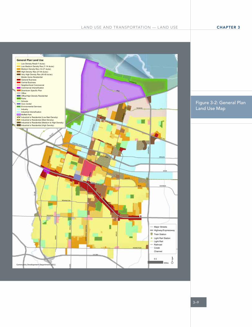
General Plan Land UseLow Density Res(0-7 du/ac)Low Medium Density Res (7-14 du/ac)Medium Density Res (14-27 du/ac)High Density Res (27-45 du/ac)Very High Density Res (45-65 du/ac)Mobile Home ResidentialGeneral BusinessCentral BusinessNeighborhood CommercialCommercial IntensificationDowntown Specific PlanOfficeOffice/High Density ResidentialParksSchoolsCivic CenterEnvironmental ServicesIndustryIndustrial IntensificationMoffett ParkIndustrial to Residential (Low Med Density)Industrial to Residential (Med Density)Industrial to Residential (Medium to High Density)Industrial to Residential (High Density)
Community Development Department, 2011
Major StreetsHighway/Expressway
Å Train Station
! Light Rail StationLight RailRailroadCreekChannel
¸0.5
Miles
figure 3-2: General Plan Land Use Map
3–9
l and use and tRanspoRtation — l and use Chapter 3

policy lt-2.1 ReCognize ThAT The CiTY iS CoMPoSed oF ReSidenTiAl, induSTRiAl And CoMMeRCiAl neighboRhoodS, eACh wiTh iTS own individuAl ChARACTeR; And Allow ChAnge ConSiSTenT wiTh ReinFoRCing PoSiTive neighboRhood vAlueS. (Previously LUTE Policy C1.1)
n LT-2.1a Prepare and update land use and transportation policies, design guidelines, regulations and engineering specifications to reflect community and neighborhood values. (Previously LUTE Action Strategy C1.1.1)
n LT-2.1b Promote and achieve compliance with land use and transportation standards. (Previously LUTE Action Strategy C1.1.2)
n LT-2.1c Require appropriate buffers, edges and transition areas between dissimilar neighborhoods and land uses. (Previously LUTE Action Strategy C1.1.3)
n LT-2.1d Require that commercial activities be conducted primarily within a building. (Previously LUTE Action Strategy C1.1.4)
policy lt-2.2 enCouRAge nodeS oF inTeReST And ACTiviTY, SuCh AS PARkS, PubliC oPen SPACeS, well PlAnned develoPMenT, Mixed uSe PRoJeCTS And oTheR deSiRAble uSeS, loCATionS And PhYSiCAl ATTRACTionS. (Previously LUTE Policy C.1.2)
n LT-2.2a Promote downtown as a unique place that is interesting and accessible to the whole City and the region. (Previously LUTE Action Strategy C1.2.1)
n LT-2.2b Encourage development of diversified building forms and intensities. (Previously LUTE Action Strategy C1.2.2)
n LT-2.2c Encourage development of multi-modal transportation centers. (Previously LUTE Action Strategy C1.2.3)
n LT-2.2d Maintain public open space areas and require private open space to be maintained. (Previously LUTE Action Strategy C1.2.4)
City of Sunnyvale GeneRal pl an – July 2011
3–10

Goal lt-3 appropriate Mix of houSinG
enSuRe owneRShiP And RenTAl houSing oPTionS in TeRMS oF STYle, Size
And denSiTY ThAT ARe APPRoPRiATe And ConTRibuTe PoSiTivelY To The
SuRRounding AReA. (Previously LUTE Goal C2 / Adopted in 1997)
policy lt-3.1 PRovide lAnd uSe CATegoRieS FoR And MAinTenAnCe oF A vARieTY oF ReSidenTiAl denSiTieS To oFFeR exiSTing And FuTuRe ReSidenTS oF All inCoMe levelS, Age gRouPS And SPeCiAl needS SuFFiCienT oPPoRTuniTieS And ChoiCeS FoR loCATing in The CoMMuniTY. (Previously LUTE Policy C2.1)
n LT-3.1a Ensure consistency with the City’s Housing and Community Revitalization Sub-Element. (Previously LUTE Action Strategy C2.1.1)
See chapter 5, Housing for further discussion and policies relating to provision of housing.
3–11
l and use and tRanspoRtation — l and use Chapter 3
n LT-3.1b Permit and maintain a variety of residential densities; including (Previously LUTE Action Strategy C2.1.2):
• Low density (0-7 dwelling units per net acre)
• Low-Medium density (7-14 dwelling units per net acre)
• Mobile home park (up to 12 mobile home dwelling units per net acre)
• Medium density (14-27 dwelling units per net acre)
• High density (27-45 dwelling units per net acre)
• Very high density (45-65 dwelling units per net acre)
n LT-3.1c Promote the maintenance and rehabilitation of existing housing. (Previously LUTE Action Strategy C2.1.3)
n LT-3.1d Support the transition of Industrial to Residential (ITR) areas as opportunities to increase housing variety and stock. (Previously LUTE Action Strategy C2.1.4)
n LT-3.1e Study housing alternatives; including, co-housing, live-work spaces and transitional housing options to serve a changing population. (Previously LUTE Action Strategy C2.1.5)
policy lt-3.2 enCouRAge The develoPMenT oF owneRShiP houSing To MAinTAin A MAJoRiTY oF houSing in The CiTY FoR owneRShiP ChoiCe. (Previously LUTE Policy C2.2)
policy lt-3.3 MAinTAin loweR denSiTY ReSidenTiAl develoPMenT AReAS wheRe FeASible. (Previously LUTE Policy C2.3)
n LT-3.3a Study the potential rezoning of properties in the R-4 and R-5 zoning districts to other zoning districts. (Previously LUTE Action Strategy C2.3.1)
n LT-3.3b Promote and preserve single-family detached housing where appropriate and in existing single-family neighborhoods. (Previously LUTE Action Strategy C2.3.2)
n LT-3.3c Monitor the progress of the remediation efforts for Futures Site 5 (General Plan Category of ITR for Low Medium Density Residential) to determine if and when conversion to residential use is appropriate. (Previously LUTE Action Strategy C2.3.3)
City of Sunnyvale GeneRal pl an – July 2011
3–12

policy lt-3.4 deTeRMine APPRoPRiATe denSiTY FoR houSing bASed on SiTe PlAnning oPPoRTuniTieS And PRoxiMiTY To SeRviCeS. (Previously LUTE Policy C2.4)
n LT-3.4a Locate higher-density housing with easy access to transportation corridors, rail transit stations, bus transit corridor stops, commercial services and jobs. (Previously LUTE Action Strategy C2.4.1)
n LT-3.4b Locate lower-density housing in proximity to existing lower density housing. (Previously LUTE Action Strategy C2.4.2)
Goal lt-4 Quality neiGhBorhoodS and diStriCtS
PReSeRve And enhAnCe The QuAliTY ChARACTeR oF SunnYvAle’S induSTRiAl,
CoMMeRCiAl And ReSidenTiAl neighboRhoodS bY PRoMoTing lAnd uSe
PATTeRnS And RelATed TRAnSPoRTATion oPPoRTuniTieS ThAT ARe SuPPoRTive
oF The neighboRhood ConCePT. (Previously LUTE Goal N1 / Adopted in 1997)
policy lt-4.1 PRoTeCT The inTegRiTY oF The CiTY’S neighboRhoodS; wheTheR ReSidenTiAl, induSTRiAl oR CoMMeRCiAl. (Previously LUTE Policy N1.1)
n LT-4.1a Limit the intrusion of incompatible uses and inappropriate development into city neighborhoods. (Previously LUTE Action Statement N1.1.1)
n LT-4.1b Foster the establishment of neighborhood associations throughout Sunnyvale to facilitate community building. (Previously LUTE Action Statement N1.1.2)
n LT-4.1cUsedensitytotransitionbetweenland use and to buffer between sensitive uses and less compatible uses. (Previously LUTE Action Statement N1.1.3)
n LT-4.1d Anticipate and avoid whenever practical the incompatibility that can arise between dissimilar uses. (Previously LUTE Action Statement N1.1.4)
n LT-4.1e Establish and monitor standards for community appearance and property maintenance. (Previously LUTE Action Statement N1.1.5)
3–13
l and use and tRanspoRtation — l and use Chapter 3

policy lt-4.2 ReQuiRe new develoPMenT To be CoMPATible wiTh The neighboRhood, AdJACenT lAnd uSeS And The TRAnSPoRTATion SYSTeM. (Previously LUTE Policy N1.2)
n LT-4.2a Integrate new development and redevelopment into existing neighborhoods. (Previously LUTE Action Statement N1.2.1)
n LT-4.2b UtilizeadoptedCitydesign guidelines to achieve compatible architecture and scale for renovation and new development in Sunnyvale’s neighborhoods. (Previously LUTE Action Statement N1.2.2)
n LT-4.2c Develop specific area plans to guide change in neighborhoods that need special attention. (Previously LUTE Action Statement N1.2.3)
policy lt-4.3 SuPPoRT A Full SPeCTRuM oF ConvenienTlY loCATed CoMMeRCiAl, PubliC And QuASi-PubliC uSeS ThAT Add To The PoSiTive iMAge oF The CiTY. (Previously LUTE Policy N1.3)
n LT-4.3a Review development proposals for compatibility within neighborhoods. (Previously LUTE Action Statement N1.3.1)
n LT-4.3b Study the adequacy /deficiency of bicycle and pedestrian access and circulation within neighborhoods. (Previously LUTE Action Statement N1.3.2)
n LT-4.3c Design streets, pedestrian paths and bicycle paths to link neighborhoods with services. (Previously LUTE Action Statement N1.3.3)
policy lt-4.4 PReSeRve And enhAnCe The high QuAliTY ChARACTeR oF ReSidenTiAl neighboRhoodS. (Previously LUTE Policy N1.4)
n LT-4.4a Require infill development to complement the character of the residential neighborhood. (Previously LUTE Action Statement N1.4.1)
n LT-4.4b Site higher density residential development in areas to provide transitions between dissimilar neighborhoods and where impacts on adjacent land uses and the transportation system are minimal. (Previously LUTE Action Statement N1.4.2)
n LT-4.4c Encourage and support home businesses that accommodate changing technologies and lifestyles, while remaining secondary to the nature of the residential neighborhood. (Previously LUTE Action Statement N1.4.3)
City of Sunnyvale GeneRal pl an – July 2011
3–14
n LT-4.4d Promote small-scale, well-designed, pedestrian-friendly spaces within neighborhoods to establish safe and attractive gathering areas. (Previously LUTE Action Statement N1.4.4)
n LT-4.4e Require amenities with new development that serve the needs of residents. (Previously LUTE Action Statement N1.4.5)
policy lt-4.5 SuPPoRT A RoAdwAY SYSTeM ThAT PRoTeCTS inTeRnAl ReSidenTiAl AReAS FRoM CiTYwide And RegionAl TRAFFiC. (Previously LUTE Policy N1.5)
n LT-4.5a Have internal residential neighborhood streets adequately serve traffic that is oriented to that neighborhood. (Previously LUTE Action Statement N1.5.1)
n LT-4.5bUtilizetheCity’sresidentialneighborhood“TrafficCalming”techniquestoaddress specific neighborhood traffic concerns. (Previously LUTE Action Statement N1.5.2)
n LT-4.5c Discourage non-neighborhood traffic from using residential neighborhood streets by accommodating traffic demand on Citywide and regional streets (Previously LUTE Action Statement N1.5.3)
n LT-4.5d Coordinate with adjacent communities to reduce and minimize commute traffic through Sunnyvale’s residential neighborhoods. (Previously LUTE Action Statement N1.5.4)
Industrial/Research and Development
policy lt-4.6 SAFeguARd induSTRY’S AbiliTY To oPeRATe eFFeCTivelY, bY liMiTing The eSTAbliShMenT oF inCoMPATible uSeS in induSTRiAl AReAS. (Previously LUTE Policy N1.6)
policy lt-4.7 SuPPoRT The loCATion oF ConvenienT ReTAil And CoMMeRCiAl SeRviCeS (e.g., ReSTAuRAnTS And hoTelS) in induSTRiAl AReAS To SuPPoRT buSineSSeS, TheiR CuSToMeRS And TheiR eMPloYeeS. (Previously LUTE Policy N1.7)
3–15
l and use and tRanspoRtation — l and use Chapter 3

policy lt-4.8 CluSTeR high inTenSiTY induSTRiAl uSeS in AReAS wiTh eASY ACCeSS To TRAnSPoRTATion CoRRidoRS. (Previously LUTE Policy N1.8)
n LT-4.8a Require high quality site, landscaping and building design for higher- intensity industrial development. (Previously LUTE Action Statement N1.8.1)
policy lt-4.9 Allow induSTRiAl, ReSidenTiAl, CoMMeRCiAl And oFFiCe uSeS in The induSTRiAl To ReSidenTiAl (iTR) FuTuReS SiTeS (SiTeS 4A, 4b, 6A, 6b, 7, 8 And 10). (Previously LUTE Policy N1.9)
Commercial/Office
policy lt-4.10 PRovide APPRoPRiATe SiTe ACCeSS To CoMMeRCiAl And oFFiCe uSeS while PReSeRving AvAilAble RoAd CAPACiTY. (Previously LUTE Policy N1.10)
n LT-4.10a Locate commercial uses where traffic can be accommodated, especially during peak periods (e.g. lunch time and commute times). (Previously LUTE Action Statement N1.10.1)
n LT-4.10b Encourage commercial enterprises and offices to provide support facilities for bicycles and pedestrians. (Previously LUTE Action Statement N1.10.2)
policy lt-4.11 ReCognize el CAMino ReAl AS A PRiMARY ReTAil CoRRidoR wiTh A Mix oF uSeS. (Previously LUTE Policy N1.11)
n LT-4.11a Use the Precise Plan for El Camino Real to protect legitimate businessinterests, while providing sufficient buffer and protection for adjacent and nearby residential uses. (Previously LUTE Action Statement N1.11.1)
n LT-4.11b Minimize linear “strip development” in favor of commercial development patterns that reduce single-purpose vehicle trips. (Previously LUTE Action Statement N1.11.2)
City of Sunnyvale GeneRal pl an – July 2011
3–16

policy lt-4.12 PeRMiT MoRe inTenSe CoMMeRCiAl And oFFiCe develoPMenT in The downTown, given iTS CenTRAl loCATion And ACCeSSibiliTY To TRAnSiT. (PReviouSlY LUTE Policy N1.12)
n LT-4.12a Use the Downtown Specific Plan to facilitate the redevelopment of downtown. (Previously LUTE Action Statement N1.12.1)
policy lt-4.13 PRoMoTe An ATTRACTive And FunCTionAl CoMMeRCiAl enviRonMenT. (Previously LUTE Policy N1.13)
n LT-4.13a Discourage commercial uses and designs that result in a boxy appearance. (Previously LUTE Action Statement N1.13.1)
n LT-4.13b Support convenient neighborhood commercial services that reduce automobile dependency and contribute positively to neighborhood character. (Previously LUTE Action Statement N1.13.2)
n LT-4.13c Provide opportunities for, and encourage neighborhood-serving commercial services in, each residential neighborhood. (Previously LUTE Action Statement N1.13.3)
n LT-4.13d Encourage the maintenance and revitalization of shopping centers. (Previously LUTE Action Statement N1.13.4)
n LT-4.13e Provide pedestrian and bicycling opportunities to neighborhood and commercial services. (Previously LUTE Action Statement N1.13.5)
Public and Quasi-Public
policy lt-4.14 SuPPoRT The PRoviSion oF A Full SPeCTRuM oF PubliC And QuASi-PubliC SeRviCeS (e.g., PARkS, dAY CARe, gRouP living, ReCReATion CenTeRS, ReligiouS inSTiTuTionS) ThAT ARe APPRoPRiATelY loCATed in ReSidenTiAl, CoMMeRCiAl And induSTRiAl neighboRhoodS And enSuRe ThAT TheY hAve beneFiCiAl eFFeCTS on The SuRRounding AReA. (Previously LUTE Policy N1.14)
n LT-4.14a Encourage carpooling to public and quasi-public services to minimize adverse traffic and parking impacts on neighborhoods (Previously LUTE Action Statement N1.14.1) 3–17
l and use and tRanspoRtation — l and use Chapter 3

n LT-4.14b Ensure the provision of bicycle support facilities at all major public use locations. (Previously LUTE Action Statement N1.14.2)
n LT-4.14c Encourage multiple uses of some facilities (e.g. religious institutions, schools, social organizations, day care) within the capacity of the land and roadway system. (Previously LUTE Action Statement N1.14.3)
n LT-4.14d Encourage employers to provide on-site facilities such as usable open space, health club facilities, and child care where appropriate. (Previously LUTE Action Statement N1.14.4)
n LT-4.14e Maintain and promote convenient community centers and services that enhance neighborhood cohesiveness and provide social and recreational opportunities. (Previously LUTE Action Statement N1.14.5)
n LT-4.14f Promote co-locating government (federal, state, county, city) activities to improve access to the community-at-large. (Previously LUTE Action Statement N1.14.6)
tranSportation
Goal lt-5 effeCtive, Safe, pleaSant and Convenient tranSportation
ATTAin A TRAnSPoRTATion SYSTeM ThAT iS eFFeCTive, SAFe, PleASAnT And
ConvenienT. (Previously LUTE Goal C3 / Adopted in 1997)
policy lt-5.1 AChieve An oPeRATing level-oF-SeRviCe (loS) oF “d” oR beTTeR on The CiTY-wide RoAdwAYS And inTeRSeCTionS, AS deFined bY The FunCTionAl ClASSiFiCATion oF The STReeT SYSTeM. (Previously LUTE Policy C3.1)
n LT-5.1a Maintain and update a functional classification of the street system. (Previously LUTE Action Strategy C3.1.1)
n LT-5.1b Monitor the operation and performance of the street system by establishing a routine data collection program and by conducting special data collection as the need arises. (Previously LUTE Action Strategy C3.1.2)
n LT-5.1c Require roadway and signal improvements for development projects to minimize decline of existing levels of service. (Previously LUTE Action Strategy C3.1.3)
City of Sunnyvale GeneRal pl an – July 2011
3–18

n LT-5.1d Study and implement physical and operational improvements to optimize roadway and intersection capacities. (Previously LUTE Action Strategy C3.141)
n LT-5.1e Promote the reduction of single occupant vehicle (SOV) trips and encourage an increase in the share of trips taken by all other forms of travel. (Previously LUTE Action Strategy C3.1.5)
n LT-5.1f Study the use of density, floor area limits, parking management, peak hour allocations and other techniques to maintain or achieve acceptable levels of service on existing roadways. (Previously LUTE Action Strategy C3.1.6)
n LT-5.1g Minimize the total number of vehicle miles traveled by Sunnyvale residents and commuters. (Previously LUTE Action Strategy C3.1.7)
policy lt-5.2 inTegRATe The uSe oF lAnd And The TRAnSPoRTATion SYSTeM. (Previously LUTE Policy C3.2)
n LT-5.2a Allow land uses that can be supported by the planned transportation system. (Previously LUTE Action Strategy C3.2.1)
n LT-5.2b Minimize driveway curb cuts and require coordinated access when appropriate. (Previously LUTE Action Strategy C3.2.2)
n LT-5.2c Encourage mixed use developments that provide pedestrian scale and transit oriented services and amenities. (Previously LUTE Action Strategy C3.2.3)
n LT-5.2d Continue to evaluate transportation impacts from land use proposals at a neighborhood and citywide level. (Previously LUTE Action Strategy C3.2.4)
n LT-5.2e Study potential transit station mixed use development. (Previously LUTE Action Strategy C3.2.5)
policy lt-5.3 oPTiMize CiTY TRAFFiC SignAl SYSTeM PeRFoRMAnCe. (Previously LUTE Policy C3.3)
n LT-5.3a Maintain the signal system and respond quickly to signal breakdowns. (Previously LUTE Action Strategy C3.3.1)
n LT-5.3b Monitor traffic signal control performance. (Previously LUTE Action Strategy C3.3.2)
n LT-5.3c Interconnect groups of traffic signals where practicable. (Previously LUTE Action Strategy C3.3.3)
3–19
l and use and tRanspoRtation — tRanspoRtation Chapter 3

n LT-5.3d Make appropriate hardware and software improvements to traffic signals. (Previously LUTE Action Strategy C3.3.4)
n LT-5.3e Make the traffic signal system responsive to all users, including bicyclists and pedestrians. (Previously LUTE Action Strategy C3.3.5)
n LT-5.3f Install and remove signals when warranted and establish an implementation schedule. (Previously LUTE Action Strategy C3.3.6)
policy lt-5.4 MAinTAin RoAdwAYS And TRAFFiC ConTRol deviCeS in good oPeRATing CondiTion. (Previously LUTE Policy C3.4)
n LT-5.4a Inventory and monitor roadway conditions and implement a regular program of pavement maintenance. (Previously LUTE Action Strategy C3.4.1)
n LT-5.4b Install permanent and painted pavement markings. (Previously LUTE Action Strategy C3.4.2)
n LT-5.4c Implement programs for repair of roadbeds, barriers and lighting. (Previously LUTE Action Strategy C3.4.3)
n LT-5.4d Respond quickly to sign damages and losses. (Previously LUTE Action Strategy C3.4.4)
n LT-5.4e Develop and implement a program for long term transportation infrastructure replacement. (Previously LUTE Action Strategy C3.4.5)
n LT-5.4f Manage on-street parking to assure safe, efficient traffic flow. (Previously LUTE Action Strategy C3.4.6)
n LT-5.4g Conduct periodic analyses of roadway facilities and collision data in order to assure traffic safety. (Previously LUTE Action Strategy C3.4.7)
policy lt-5.5 SuPPoRT A vARieTY oF TRAnSPoRTATion ModeS. (Previously LUTE Policy C3.5)
n LT-5.5a Promote alternate modes of travel to the automobile. (Previously LUTE Action Strategy C3.5.1)
n LT-5.5b Require sidewalk installation in subdivisions of land and in new, reconstructed or expanded development. (Previously LUTE Action Strategy C3.5.2)
n LT-5.5c Support land uses that increase the likelihood of travel mode split. (Previously LUTE Action Strategy C3.5.3)
n LT-5.5d Maximize the provision of bicycle and pedestrian facilities. (Previously LUTE Action Strategy C3.5.4)
City of Sunnyvale GeneRal pl an – July 2011
3–20

n LT-5.5e Implement the City of Sunnyvale Bicycle Plan. (Previously LUTE Action Strategy C3.5.5)
n LT-5.5f Support an efficient and effective paratransit service and transportation facilities for people with special transportation needs. (Previously LUTE Action Strategy C3.5.6)
n LT-5.5g Ensure safe and efficient pedestrian and bicycle connections to neighborhood transit stops. (Previously LUTE Action Strategy C3.5.7)
n LT-5.5h Work to improve bus service within the City, including linkages to rail. (Previously LUTE Action Strategy C3.5.8)
policy lt-5.6 MiniMize exPAnSion oF The CuRRenT RoAdwAY SYSTeM, whiCh MAxiMizing oPPoRTuniTieS FoR AlTeRnATive TRAnSPoRTATion SYSTeMS And RelATed PRogRAMS. (Previously LUTE Policy C3.6)
n LT-5.6a Develop clear, safe and convenient linkages between all modes of travel; including, access to transit stations and stops and connections between work, home and commercial sites. (Previously LUTE Action Strategy C3.6.1)
n LT-5.6b Promote public and private transportation demand management. (Previously LUTE Action Strategy C3.6.2)
policy lt-5.7 PuRSue loCAl, STATe And FedeRAl TRAnSPoRTATion Funding SouRCeS To FinAnCe CiTY TRAnSPoRTATion CAPiTAl iMPRoveMenT PRoJeCTS ConSiSTenT wiTh CiTY PRioRiTieS. (Previously LUTE Policy C3.7)
n LT-5.7a Develop alternatives and recommendations for funding mechanisms to finance the planned transportation system. (Previously LUTE Action Strategy C3.7.1)
n LT-5.7b Develop a funding mechanism where new and existing land uses equitably participate in transportation system improvements. (Previously LUTE Action Strategy C3.7.2)
policy lt-5.8 PRovide A SAFe And CoMFoRTAble SYSTeM oF PedeSTRiAn And biCYCle PAThwAYS. (Previously Community Design Policy B.2)
3–21
l and use and tRanspoRtation — tRanspoRtation Chapter 3

Modal Balance
policy lt-5.9 APPRoPRiATe ACCoMModATionS FoR MoToR vehiCleS, biCYCleS, And PedeSTRiAnS ShAll be deTeRMined FoR CiTY STReeTS To inCReASe The uSe oF biCYCleS FoR TRAnSPoRTATion And To enhAnCe The SAFeTY And eFFiCienCY oF The oveRAll STReeT neTwoRk FoR biCYCliSTS, PedeSTRiAnS, And MoToR vehiCleS.
policy lt-5.10 All ModeS oF TRAnSPoRTATion ShAll hAve SAFe ACCeSS To CiTY STReeTS.
policy lt-5.11 The CiTY Should ConSideR enhAnCing STAndARdS FoR PedeSTRiAn FACiliTieS.
City of Sunnyvale GeneRal pl an – July 2011
3–22

Transport Vs. Non-Transport Uses
policy lt-5.12 CiTY STReeTS ARe PubliC SPACe dediCATed To The MoveMenT oF vehiCleS, biCYCleS And PedeSTRiAnS. PRoviding SAFe ACCoMModATion FoR All TRAnSPoRTATion ModeS TAkeS PRioRiTY oveR non-TRAnSPoRT uSeS. FACiliTieS ThAT MeeT MiniMuM APPRoPRiATe SAFeTY STAndARdS FoR TRAnSPoRT uSeS ShAll be ConSideRed beFoRe non-TRAnSPoRT uSeS ARe ConSideRed.
policy lt-5.13 PARking iS The SToRAge oF TRAnSPoRTATion vehiCleS And ShAll noT be ConSideRed A TRAnSPoRT uSe.
policy lt-5.14 hiSToRiCAl PReCedenCe FoR STReeT SPACe dediCATed FoR PARking ShAll be A leSSeR ConSideRATion ThAn PRoviding STReeT SPACe FoR TRAnSPoRTATion uSeS when deTeRMining The APPRoPRiATe FuTuRe uSe oF STReeT SPACe.
policy lt-5.15 PARking ReQuiReMenTS FoR PRivATe develoPMenT ShAll APPlY To oFF-STReeT PARking onlY.
n LT-5.15a Incentives to offset impacts of roadway changes to non-transportation users shall be considered when retrofitting roadways.
3–23
l and use and tRanspoRtation — tRanspoRt vs. non-tRanspoRt uses Chapter 3
Use Of Engineering/Planning Criteria
policy lt-5.16 when deCiSionS on The ConFiguRATion oF RoAdwAY SPACe ARe MAde, STAFF ShAll PReSenT oPTionS, inCluding AT A MiniMuM An oPTion ThAT MeeTS MiniMuM SAFeTY-RelATed deSign STAndARdS FoR MoToR vehiCleS, biCYCleS And PedeSTRiAnS.
policy lt-5.17 bike ReTRoFiT PRoJeCTS ShAll be evAluATed bASed on The MeRiTS oF eACh PRoJeCT in The ConTexT oF engineeRing And PlAnning CRiTeRiA.
n LT-5.17a The City shall maintain engineering and planning criteria with respect to roadway geometry, collisions, travel speed, motor vehicle traffic volume, and parking supply and demand (on and off street) to guide decisions on the provision of bike lanes.
policy lt-5.18 The CiTY CounCil ShAll MAke The FinAl deCiSionS on RoAdwAY SPACe ReConFiguRATion when RoAdwAY ReConFiguRATion will ReSulT in ChAngeS To exiSTing ACCoMModATionS.
policy lt-5.19 PubliC inPuT on RoAdwAY SPACe ReConFiguRATion ShAll be enCouRAged And PReSenTed indePendenTlY oF TeChniCAl engineeRing And PlAnning AnAlYSeS.
City of Sunnyvale GeneRal pl an – July 2011
3–24

Design Standards/Safety
policy lt-5.20 iF STReeT ConFiguRATionS do noT MeeT MiniMuM deSign And SAFeTY STAndARdS FoR All uSeRS, ThAn STAndARdizATion FoR All uSeRS ShAll be PRioRiTY.
policy lt-5.21 SAFeTY ConSideRATionS oF All ModeS ShAll TAke PRioRiTY oveR CAPACiTY ConSideRATionS oF AnY one Mode.
n LT-5.21a For each roadway space retrofit project, a bike and pedestrian safety study shall be included in the staff report to evaluate the route in question.
3–25
l and use and tRanspoRtation — desiGn standaRds/safet y Chapter 3

eConoMy
Goal lt-6Supportive eConoMiC developMent environMent
An eConoMiC develoPMenT enviRonMenT ThAT iS SuPPoRTive oF A wide
vARieTY oF buSineSSeS And PRoMoTeS A STRong eConoMY wiThin exiSTing
enviRonMenTAl, SoCiAl, FiSCAl And lAnd uSe ConSTRAinTS. (Previously Socio-economic Goal 5.1B/Adopted in 1989)
Goal lt-7BalanCed eConoMiC BaSe
A bAlAnCed eConoMiC bASe ThAT CAn ReSiST downTuRnS oF AnY one induSTRY
And PRovideS Revenue FoR CiTY SeRviCeS. (Previously Socio-economic Goal 5.1C / Adopted in 1989)
Sunnyvale is home to a variety of corporate headquarters.
See the land Use and transportation section of this chapter for further discussion and policies on integration of land use and transportation improvements.
City of Sunnyvale GeneRal pl an – July 2011
3–26

The economic health of Sunnyvale depends, in part, on the success of its businesses and the City’s ability to create a business-friendly environment. The City of Sunnyvale and its business owners share a common goal of increasing the City’s economic vitality by creating jobs, services and increased tax revenue for the community. To foster a supportive economic environment, the City seeks to attract new businesses, retain existing ones and provide means for businesses to expand and change as the economy changes. These programs can be achieved through a variety of land use policies and economic development activities.
One of the key aspects of the City’s Economic Development program is to provide a variety of land uses and buildings to support a diverse mix of businesses, from small industrial start-ups to large corporation headquarters, from new restaurants to established retail centers and from medical office centers to individual professional offices. These areas are established and protected for businesses through General Plan designations, zoning districts and policies that support commercial areas, preserve affordable business spaces and protect large parcels for appropriate commercial or industrial development. In the past 10 years the City has implemented a variety of zoning districts and specific plans to preserve and enhance commercial and industrial areas, including the Downtown Specific Plan (2003), the Moffett Park Specific Plan (2004), the Places of Assembly Combining District (2006) and the Precise Plan for El Camino Real (2007). All of these plans have supported businesses through preserving space for commercial and industrial areas, enhancing the design and amenities needed to support these areas and encouraging non-jobs producing uses (such as places of assembly) in appropriate and non-disruptive locations.
Other land use issues such as adequate housing and transportation can affect the vitality of the business community. In order to support a variety of industrial land uses and jobs, the business community has supported a range of housing options and prices. The availability of housing enhances economic growth, supports businesses, reduces commuting distances and gives employees some opportunities to both work and live in a community. Increased traffic congestion and commute time can affect businesses as well. The City continues to pursue a variety of land use strategies that achieve a greater integration of land uses that shorten or reduce trips, or make alternative transportation modes more convenient. The City is also supportive of TOD programs developed by businesses.
The City also seeks to support businesses by providing a supportive regulatory environment. The City has been a leader in permitting services with the One-Stop Permit Center and the online E-Permit system. The City’s Economic Development program works closely with businesses and encourages communication when new plans or policies may affect them, to ensure that their needs are recognized and included in any regulation updates.
As of 2011, the major economic development issues facing the City are the need to support and expand the retail services available in the City, preserve a variety of spaces for start-up businesses and balance the need to introduce mixed-use areas with the need to provide adequate commercial and industrial space for businesses. The City will continue to use a variety of strategies to sustain a dynamic local economy that attracts investment, increases the tax base, generates public revenue and creates employment opportunities.
3–27
l and use and tRanspoRtation — economy Chapter 3

Policies supporting Goal LT-6 (Supportive Economic Development Environment)
policy lt-6.1 PRovide exiSTing buSineSSeS wiTh oPPoRTuniTieS To gRow
And AdoPT new induSTRieS. (Previously Socio-economic Policy 5.1B.1)
n LT-6.1a Monitor the effect of City policies on business development and consider the effects on the overall health of business within the City. (Previously Socio-economic Policy 5.1B.3)
n LT-6.1b Support transportation demand management programs and other ride sharing programs countywide.(Previously Socio-economic Action Statement 5.1B.4c)
n LT-6.1c Participate in partnerships with local industry/businesses in order to facilitate communication and address mutual concerns.(Previously Socio-economic Policy 5.1B.4)
policy lt-6.2 PRoMoTe buSineSS oPPoRTuniTieS And buSineSS ReTenTion
in SunnYvAle. (Previously Socio-economic Policy 5.1C.4)
policy lt-6.3 PARTiCiPATe in RegionAl eFFoRTS To ReSPond To
TRAnSPoRTATion And houSing PRobleMS CAuSed bY eConoMiC gRowTh in
oRdeR To iMPRove The QuAliTY oF liFe And CReATe A beTTeR enviRonMenT
FoR buSineSS To FlouRiSh. (Previously Socio-economic Policy 5.1B.4)
n LT-6.3a Support land use policies to achieve a healthy relationship between the creation of new jobs and housing. (Previously Socio-economic Action Statement 5.1B.4a)
City of Sunnyvale GeneRal pl an – July 2011
3–28

policy lt-6.4 enCouRAge SuSTAinAble induSTRieS ThAT eMPhASize ReSouRCe eFFiCienCY, enviRonMenTAl ReSPonSibiliTY, And The PRevenTion oF PolluTion And wASTe. (Previously Land Use and Transportation Policy C4.4)
policy lt-6.5 enCouRAge CReATion oR inSTAllATion oF PiloT PRogRAMS (SuCh AS blooM boxeS oR voiCe oveR inTeRneT PRoToCol) FoR eMeRging induSTRieS in boTh PRivATe And PubliC FACiliTieS. (NEW)
policy lt-6.6 SuPPoRT A SeAMleSS develoPMenT Review PRoCeSS (dPiC) And exPAnd The one-SToP PeRMiT CenTeR. (NEW)
Policies supporting Goal LT-7 (Balanced Economic Base)
policy lt-7.1 MAinTAin A diveRSiTY oF CoMMeRCiAl enTeRPRiSeS And induSTRiAl uSeS To SuSTAin And bolSTeR The loCAl eConoMY. (Previously Land Use and Transportation Action Statement C4.1)
n LT-7.1a Promote a variety of commercial, retail and industrial uses, including Neighborhood Shopping, General Business, Office, Clean Technology, and Industrial/Research and Development. (Previously Land Use and Transportation Action Statement C4.1.1)
n LT-7.1b Ensure that rezoning industrial and commercial areas or specific sites will not significantly hurt the City’s economic base. (NEW)
policy lt-7.2 enCouRAge lAnd uSeS ThAT geneRATe Revenue, while
PReSeRving A bAlAnCe wiTh oTheR CiTY needS, SuCh AS houSing. (Previously Socio-economic policy 5.1C.3)
3–29
l and use and tRanspoRtation — economy Chapter 3

n LT-7.2a Monitor revenues generated by different economic sectors on an on-going basis. (Socio-Economic Policy C.2)
policy lt-7.3 PRoMoTe CoMMeRCiAl uSeS ThAT ReSPond To The CuRRenT
And FuTuRe ReTAil SeRviCe needS oF The CoMMuniTY. (Previously Land Use and Transportation Action Statement C4.1.3)
policy lt-7.4 CReATe A STRong, idenTiFiAble CenTRAl buSineSS diSTRiCT
ThAT PRovideS RegionAl And CiTYwide ShoPPing oPPoRTuniTieS. (Previously Land Use and Transportation Action Statement C4.1.4)
policy lt-7.5 enCouRAge The ATTRACTion And ReTenTion oF buSineSSeS
ThAT PRovide A RAnge oF Job oPPoRTuniTieS. (Previously Land Use and Transportation Action Statement C4.1.5)
City of Sunnyvale GeneRal pl an – July 2011
3–30

special Use facility — a park or recreation facility oriented toward single-purpose use (e.g. las palmas tennis Center or Baylands park).
school open space — public school-owned open space lands, not including school buildings or playgrounds — that are under agreement with the City for public use and which by agreement the City is responsible for maintain. these sites consist largely of school athletic fields.
open SpaCe
Goal lt-8 adeQuate and BalanCed open SpaCe
PRovide And MAinTAin AdeQuATe And bAlAnCed oPen SPACe And ReCReATion
FACiliTieS FoR The beneFiT oF MAinTAining A heAlThY CoMMuniTY bASed
on CoMMuniTY needS And The AbiliTY oF The CiTY To FinAnCe, ConSTRuCT,
MAinTAin And oPeRATe TheSe FACiliTieS now And in The FuTuRe. (Previously Open Space and Recreation Goal A / Adopted in 2006)
Goal lt-9 reGional approaCh to open SpaCe
A RegionAl APPRoACh To PRoviding And PReSeRving oPen SPACe And
PRoviding oPen SPACe And ReCReATionAl SeRviCeS, FACiliTieS And AMeniTieS
FoR The bRoAdeR CoMMuniTY. (Previously Open Space and Recreation Goal C / Adopted in 2006)
The City strives to create community through its people, parks and programs. It provides a wide range of accessible, high quality open space and recreational programs and facilities to meet the desires of a diverse and changing Sunnyvale community, all which have a role in creating a healthy community and contribute to a high quality of life.
As of 2006 Sunnyvale has 20 parks comprising 223 acres, including 25 acres of athletic fields and 72 acres of developed parkland at Baylands Park; nine special use facilities comprising 355 acres including the Sunnyvale Golf Course, Sunken Gardens Nine-Hole Course, Baylands Park Wetlands and the closed landfill property; and has formal agreements for use and maintenance of 118 acres of school open space, primarily the school athletic fields. Also included in the total open space acreage are 49 acres of public grounds, which include sites such as the orchards as well as the open space surrounding the Community Center and Civic Center campuses. The total open space acreage is depicted below. Overall, in 2006 Sunnyvale maintained and provided almost 5.7 acres of park and open space for every 1,000 residents in the City (See Figure 3-3, Level of Service for Park Types).
3–31
l and use and tRanspoRtation — open space Chapter 3

US-101
MAR
Y
LAW
REN
CE
WO
LFE
TASMAN
HOMESTEAD
MONROE
EL CAMINO REALKIFER
FREMONT
MAT
HILD
A
GRAN
T
FAIR
OAK
S
BERN
ARDO
BOW
ERS
MAUDE
MIDDLEFIELD
ARQUES
JAVA
REED
HOLL
ENBE
CK
REMINGTON
CARIBBEAN
GREA
T AM
ERIC
A
SUNN
YVAL
E
STEL
LIN
G
SUN
NYV
ALE
SARA
TOG
A
OLD SAN FRANCISCO
CALIFORNIA
FAIR
OAK
S
CENTRAL EXPRESSWAY
US-101
CA-8
5
US-280
CA-237
EVELYN
Las PalmasPark
De AnzaPark
San AntonioPark
Greenwood ManorPark
SerraPark
Ortega Park
PanamaPark
RaynorPark
PonderosaPark
BralyPark
WashingtonPark
CanneryPark
EncinalPark
MurphyPark
Fair OaksPark
Victory Village Park
OrchardGardens
Park
LakewoodPark
FairwoodPark
Baylands Park
Improved Park
LAKEWOOD
EAST MURPHY
WEST MURPHY
WASHINGTON
PONDEROSA
ORTEGA
RAYNOR
SERRA
DE ANZA
Data Collected 2005
Neighborhood Planning AreasNeighborhood Planning Area
Public Park
Special Use Facility
Regional Trail
School Field (City Managed)
Public Schools
Public Grounds
Major StreetsHighway/Expressway
ÅTrain Station
! Light Rail StationLight RailRailroadCreekChannel
¸0.5
Miles
figure 3-3: Neighborhood Planning Areas
City of Sunnyvale GeneRal pl an – July 2011
3–32

figure 3-4: Level of Service for Park Types
Park Type
# of Sites
# of Acres
% of Total
Inventory
Existing LOS
(acres/ 1,000
population*)
Parks 20 223 30 1.69
School open Space 19 118 15.8 0.90
Special use Areas 9 355 47.7 2.70
Public grounds 5 49 6.5 0.37
TOTALS 53 745 100% 5.66
*Based on 2005 U.S. Census data showing the City of Sunnyvale Population is 131,700
From 1992 to 2006, City-owned open space acreage increased by 2.6 acres with Plaza del Sol and Victory Village Park. Through agreements, the City has made an additional eight acres available to the public at Braly and Ponderosa schools; opened 3.45 miles of the Bay Trail to public use; finished improving the John W. Christian Greenbelt; and builta50-meterswimmingpoolinpartnershipwiththeFremontUnionHighSchoolDistrict. Major physical improvements since the early 1990s also include a new 23,000 square foot Senior Center, three new tennis courts and a snack bar at the Tennis Center; a skate park at Fair Oaks Park; a boardwalk at Baylands Park; and the relocation of a 1918 redwood barn (Bianchi Barn) from San Jose to Orchard Heritage Park.
It is generally accepted that parks best serve those living immediately adjacent to them, although today’s population is highly mobile and will readily use parks throughout the City as well as in neighboring cities and not be limited to parks within walking distance. The City has identified neighborhood planning areas to describe this concept. Neighborhood planning areas are generally bounded by traffic arterials, are served with an elementary school or park within walking distance, and have neighborhood shopping facilities within a half-mile radius. Within the City there are nine neighborhood planning areas that are used by the City as a means to describe and evaluate the City’s physical organization and distribution of parks (see Figure 3-5 for neighborhood planning area boundaries.)
For the purposes of identifying areas which are relatively underserved by open space, a neighborhood approach was taken, looking at which households were within specified distances from City open space sites. Parks of three acres or less in size were considered to primarily serve those living with a quarter mile radius of the park. For larger parks, a half mile radius was used, because the larger parks generally include more amenities and can serve more people. For school open space, which represents athletic fields without amenities such as restrooms or playgrounds, a quarter mile radius was used.
Once the half-mile and quarter-mile buffers are drawn around each open space site, it is possible to see which pockets of the City are not within these designated service areas. Figure 3-4 depicts all park sites with their accompanying buffers, or service areas. An Open Space Initiative was suggested to evaluate areas as being currently underserved by open space and determine measures to be taken to mitigate the impact of these service gaps.
3–33
l and use and tRanspoRtation — open space Chapter 3

US-101
US HWY 280
MAR
Y
LAW
REN
CE
WO
LFE
TASMAN
HOMESTEAD
MONROE
EL CAMINO REALKIFER
FREMONT
MAT
HILD
A
GRA
NT
FAIR
OAK
S
BERN
ARDO
BOW
ERS
WALSH
MAUDE
MIDDLEFIELD
ARQUES
JAVA
REED
HO
LLEN
BECK
REMINGTON
CARIBBEAN
GRE
AT A
MER
ICA
SUN
NYVA
LE
STEL
LIN
G
SUN
NYV
ALE
SARA
TOG
A
OLD SAN FRANCISCO
CALIFORNIA
FAIR
OAK
S
CENTRAL EXPRESSWAY
US-101
CA-8
5
US-280
CA-237
EVELYNCivic Center
CommunityCenter
Orchard
SunnyvaleHeritageCenter
SeniorCenter
Three Points Corners
HomesteadHigh
West ValleyElementary Cupertino
Middle
NimitzElementary
StocklmeirElementary
FremontHigh
LaurelwoodElementary
PetersonMiddle
PonderosaElementary
BralyElementary
VargasElementary
SunnyvaleMiddle
Cherry ChaseElementary
CumberlandElementary
HollenbeckSchool Field
EllisElementary
BishopElementary
San MiguelElementary
ColumbiaMiddle
LakewoodElementary
Fairwood Elementary
WilcoxHighLas Palmas
Park
De AnzaPark
San AntonioPark
Greenwood ManorPark
SerraPark
Ortega Park
PanamaPark
RaynorPark
PonderosaPark
BralyPark
WashingtonPark
CanneryPark
EncinalPark
MurphyPark
Fair OaksPark
Victory VillagePark
OrchardGardens
Park
LakewoodPark
FairwoodPark
Baylands Park
Improved Park
Wetlands
West Hill
RecycleHill
South Hill
Moffett FieldGolf Course
SunnyvaleGolf Course
Swim Pool
Skate Park
SwimPool
Lawn Bowling Sq
Plaza Del SolSwim Pool
TennisCenter
Swim Pool
Swim Pool Sunken GardensGolf Course
RaynorMulti-Purpose
Center
John W. Christian Greenbelt
John W. Christian Greenbelt
San Francisco Bay Trail
EAST EVELYN(ITR 4)
MORSE/TASMAN(ITR 7 & 8)
COLUMBIAWEST
ACALANES/IOWA
LAKESIDE SPECIFIC PLAN
KNICKERBOCKER
SOUTHEASTCORNER
BIRDLAND
LAKEWOODSOUTH
MIDTOWN
SAN MIGUELEAST
Department of Parks and Recreation, 2005
Open Space Service and Gap AreasPublic Park
Special Use Facility
Regional Trail
School Field (City Managed)
Public Schools
Public Grounds
Open Space Service Area
Underserved Residential "Gap" Area
Residential Area Served by Public Park
Residential Area Served by School Field
Non-Residential Areas
Major StreetsHighway/Expressway
Å Train Station
! Light Rail StationLight RailRailroadCreekChannel
¸0.5
Miles
figure 3-5: Park and School field Service and Open Space Gap Areas
City of Sunnyvale GeneRal pl an – July 2011
3–34

In 1990, the National Recreation and Park Association (NRPA) developed standards or guidelines which recommended 4-6 acres of open space per 1000 population. Although it would be helpful to have a standard for the amount and kind of open space appropriate for the Sunnyvale community, the NRPA has since acknowledged the difficulty in setting standards that would be applicable to all communities, given each community’s unique characteristics. The 1990 NRPA standard is, however, still widely used as a starting point of discussion. At 5.7 acres per 1000, Sunnyvale falls well within that guideline.
The public has expressed interest in increasing most park services, programs, resources and facilities, with the most emphasis on additional open space or enhancement of existing facilities. Much of the stated demand is for sports/athletic fields; however, there is a general sense that additional open space is increasingly important as the City’s population increases.
Sunnyvale is experiencing a number of trends related to open space:
n Requiring residential developments to include buildings for community gatherings/meetings.
n Businesses are increasingly using open space during the work day for the benefit of their employees, resulting in a large increase in the use of picnic sites and athletic fields near large businesses. The daytime population for Sunnyvale was estimated at 149,923in2000bytheUSCensusBureau,almost20,000morethanthenighttimepopulation. Staff has noted the phenomenon particularly in the northern part of the City. Encinal Park, Lakewood Park, Sunnyvale Baylands Parks and Fair Oaks Park each get heavy use during the day from nearby day-time only residents.
n New residential development is planned in several locations throughout City. Figures 3-4 and 3-5 show areas where increased residential growth can be expected. Seven areas are noted in the table below, along with estimates of the magnitude for which growth is being planned. Evelyn/Wolfe, Lakeside Specific Plan, and Tasman/Morse areas are also identified as being underserved by open space (see Figure 3-6, Projected Residential Growth). The underserved nature of these areas can be exacerbated by the planned residential growth.
3–35
l and use and tRanspoRtation — open space Chapter 3

US-101
MAR
Y
LAW
REN
CE
WO
LFE
TASMAN
HOMESTEAD
MONROE
EL CAMINO REALKIFER
FREMONT
MAT
HILD
A
GRA
NT
FAIR
OAK
S
BERN
ARDO
BOW
ERS
MAUDE
MIDDLEFIELD
ARQUES
JAVA
REED
HO
LLEN
BECK
REMINGTON
CARIBBEAN
GRE
AT A
MER
ICA
SUN
NYVA
LE
STEL
LIN
G
SUN
NYV
ALE
SARA
TOG
A
OLD SAN FRANCISCO
CALIFORNIA
FAIR
OAK
S
CENTRAL EXPRESSWAY
US-101
CA-8
5
US-280
CA-237
EVELYN
Civic Center
CommunityCenter
Orchard
SunnyvaleHeritageCenter
SeniorCenter
Las PalmasPark
De AnzaPark
San AntonioPark
Greenwood ManorPark
SerraPark
Ortega Park
PanamaPark
RaynorPark
PonderosaPark
BralyPark
WashingtonPark
CanneryPark
EncinalPark
MurphyPark
Fair OaksPark
Victory Village Park
OrchardGardens
ParkLakewood
ParkFairwood
Park
Baylands ParkImproved Park
LAKEWOOD
EAST MURPHY
WEST MURPHY
WASHINGTON
PONDEROSA
ORTEGA
RAYNOR
SERRA
DE ANZA
LAKESIDESPECIFIC PLAN
MORSE/TASMAN(ITR 7 & 8)
NORTHRUPGRUMMAN
(ITR 5)
ARQUES/FAIR OAKS
(ITR 6a)
EVELYN/WOLFE (ITR 4b)
TIMBERPINE/LILY
DOWNTOWN
(ITR 4a)
Department of Parks and Recreation, 2005
Residential Growth AreasLow to Medium Density Residential Growth
High to Very High Density Residential Growth
Neighborhood Planning Area
Public Park
Special Use Facility
Regional Trail
School Field (City Managed)
Public Grounds
Major StreetsHighway/Expressway
ÅTrain Station
! Light Rail StationLight RailRailroadCreekChannel
¸0.5
Miles
figure 3-6: future Residential Growth Areas
City of Sunnyvale GeneRal pl an – July 2011
3–36

figure 3-7: Projected Residential Growth
Area of Residential Growth Neighborhood Planning Area
Within ½ Mile of Park?
Projected Build Out/Increase in
Population
Timberpine/lily Ponderosa Ponderosa Park 320
evelyn/wolfe (includes iTR 4a and 4b)
Ponderosa no 5,680
Arques/Fair oaks (iTR 6a) east Murphy Fair oaks Park 950
lakeside Specific Plan east Murphy no 1,416
downtown washington Split: ½ washington Park
1/3 Murphy Park 1/6 las Palmas Park
3,900
Tasman/Morse (includes iTR 7 and 8)
lakewood no 7,435
northrup grumman (iTR 5) west Murphy Split: ½ Murphy Park
¼ Fair oaks Park ¼ victory village Park
3,000
In 2006, the City developed Key Initiatives to respond to demands for increased open space and the areas identified as having “service gaps” and being underserved by current open space offerings. These Key Initiatives were further evaluated in the Parks of the Future Study, which was completed in 2009. The 2006 Key Initiatives and the 2009 Parks of the Future study recommendations are described as follows:
n Key Initiative #1 — Evaluate how well the following City-owned sites meet the open space and recreation priorities and determine which should be pursued for development as public open space;
• MurphyParksiteHousingonJacksonAvenue
• OrchardGardensParksiteHousingonGarnerAvenue
• FairOaksIndustrialComplex
In 2009, the City Council directed staff to sell the Orchard Gardens and Murphy Park park-site housing at a future time when the market improves and use the proceeds from the sale of the properties to fund other park and open space priorities. The Fair Oaks Industrial Complex, also known as the Morse Avenue park site, was identified as high priority for development as a Neighborhood Park. (In 2010 the planning and design for Morse Avenue Park was started, with an expect completion date in 2013.)
3–37
l and use and tRanspoRtation — open space Chapter 3

n Key Initiative #2 — Evaluate areas identified as being currently underserved by open space and determine measures to be taken to mitigate the impact of these service gaps.
In 2009, the City Council adopted as priorities for acquisition and development of new open space the following areas:
• Morse/Tasman(includesITR7&8)
• EastEvelyn(includesITR4)
• Acalanes/Iowa(BetweenwesternborderofSunnyvaleandMaryAvenue,between El Camino and Evelyn)
• Downtown
• CommunityCenterarea
• EastSunnyvaleITR
The Council also directed staff to:
• Actively identify land for acquisition and development, with particularemphasis on areas identified as priorities for new open space
• Revisit the City/School Use Agreements and look for opportunities toexpand and/or redefine the existing partnerships to best meet the City’s needs.[This effort was underway in 2010 and will be on-going.]
• Worktogethertodevelopalong-termplanfortherecreationaluseoftheWest Hill, Recycle Hill and South Hill portions of the Sunnyvale Landfill.
• Explorethepotentialfornewoff-streettrailsandcoordinationofon-streetbike connections.
n Key Initiative #3 — Determine whether or not to continue agreement with Santa Clara County for operation of Sunnyvale Baylands Park past 2011 (agreement was to expire in 2011 and the notice of intent was required by December 2008).
In December 2009 this agreement was renewed for an additional 25 years. It now expires in 2036.
n Key Initiative #4 — Evaluate how the Raynor Activity Center meets open space and recreation priorities and determine what should be done with the site (e.g. keep for use as recreation facility; tear down and use for civic, non-recreation use; sell).
In June 2010, City Council declared that the Raynor Activity Center was no longer needed for public purposes and available for long-term lease. The City anticipates making a determination on the future use of the Raynor Activity Center in 2011.
n Key Initiative #5 - Consider revisions to Sunnyvale Municipal Code (e.g. evaluate whether to include commercial development in park dedication or mitigation; consider changes to the open space acreage dedication amount.)
City of Sunnyvale GeneRal pl an – July 2011
3–38

In 2009, the City Council adopted as a target to maintain an open space level of service of 5.34 acres per 1,000 residents. Council also directed staff to prepare an amendment to Sunnyvale Municipal Code Chapter 18.10 and Chapter 19.74 relating to park dedication and in-lieu fees to change the facility standard to 3.0 acres per 1,000 population from its current standard of 1.25 acres per 1,000 population, in accordance with Fee Mitigation Act Requirements. This was completed on November 24, 2009 when Council raised the park facility standard from 1.25 acres per 1,000 residents to 3.0 acres per 1,000 residents over a three year period. In addition, the Council directed staff to further explore the feasibility of establishing expanded or modified Development Impact Fees under the Mitigation Fee Act.
Policies supporting Goal LT-8 (Adequate and Balanced Open Space)
policy lt-8.1 Follow MAnAgeMenT And PRevenTive MAinTenAnCe STRATegieS To exTend The uSAble liFe oF oPen SPACeS And ReCReATion FACiliTieS, SuCh AS PlAnning FoR And iMPleMenTing “non-uSe TiMeS” FoR oPen SPACe And FACiliTieS in oRdeR To ASSuRe AdeQuATe MAinTenAnCe And RegeneRATion TiMe. (Previously Open Space and Recreation Policy 2.2.A.1)
policy lt-8.2 AdoPT MAnAgeMenT, MAinTenAnCe And develoPMenT PRACTiCeS ThAT MiniMize negATive iMPACTS To The nATuRAl enviRonMenT, SuCh AS SuPPoRTing And enFoRCing The inTegRATed PeST MAnAgeMenT SYSTeM; And lAndSCAPing in wAYS whiCh MiniMize The need FoR wATeR. (Previously Open Space and Recreation Policy 2.2.A.2)
policy lt-8.3 PuRSue The ACQuiSiTion oF APPRoPRiATe FedeRAl lAndS CuRRenTlY loCATed AT The FoRMeR MoFFeTT nAvAl AiR STATion. (Previously Open Space and Recreation Policy 2.2.A.3)
3–39
l and use and tRanspoRtation — open space Chapter 3

policy lt-8.4 MAinTAin exiSTing PARk And oPen SPACe TRee invenToRY ThRough The RePlACeMenT oF TReeS wiTh An eQuAl oR gReATeR nuMbeR oF TReeS when TReeS ARe ReMoved due To diSeASe, PARk develoPMenT oR oTheR ReASonS. (Previously Open Space and Recreation Policy 2.2.A.4)
policy lt-8.5 MAinTAin PARk And oPen SPACe TRee invenToRY on A SYSTeM wide bASiS RATheR ThAn A SiTe-bY-SiTe bASiS wiTh An undeRSTAnding ThAT TheRe iS no Single oPTiMuM nuMbeR oF TReeS FoR A PARTiCulAR SiTe. (Previously Open Space and Recreation Policy 2.2.A.5)
policy lt-8.6 MAinTAin A woRking FRuiT oRChARd ThRoughouT The lARgeST PoRTion oF oRChARd heRiTAge PARk FoR AS long AS PRACTiCAl. (Previously Open Space and Recreation Policy 2.2.A.6)
policy lt-8.7 ConduCT A CoST/beneFiT AnAlYSiS To deTeRMine wheTheR The geneRAl CoMMuniTY would be well-SeRved duRing non-SChool houRS bY CAPiTAl iMPRoveMenTS To SChool-owned oPen SPACe And/oR ReCReATionAl FACiliTieS. The CoST/beneFiT AnAlYSiS Should TAke inTo ACCounT ongoing MAinTenAnCe CoSTS And ReSPonSibiliTieS. when iT iS deTeRMined ThAT The CoMMuniTY would be well SeRved bY The CAPiTAl iMPRoveMenT, The CiTY will ConSideR Funding A ShARe oF The CoSTS oF ThoSe iMPRoveMenTS PRoPoRTionATe To The CiTY’S uSe. (See AlSo FiSCAl MAnAgeMenT Sub-eleMenT FoR FiSCAl PoliCieS.) (Previously Open Space and Recreation Policy 2.2.A.7)
City of Sunnyvale GeneRal pl an – July 2011
3–40

policy lt-8.8 SuPPoRT The ACQuiSiTion oR JoinT uSe ThRough AgReeMenTS wiTh PARTneRS oF SuiTAble SiTeS To enhAnCe SunnYvAle’S oPen SPACeS And ReCReATion FACiliTieS bASed on CoMMuniTY need And ThRough SuCh STRATegieS AS develoPMenT oF eASeMenTS And RighT-oF-wAYS FoR oPen SPACe uSe, ConveRSion oF SiTeS To oPen SPACe FRoM develoPed uSe oF lAnd And lAndbAnking. (Previously Open Space and Recreation Policy 2.2.A.8)
policy lt-8.9 ReFRAin FRoM engAging in The develoPMenT oF oPen SPACe And/oR ReCReATionAl FACiliTieS wiThouT PRioR ASSuRAnCe ThAT ongoing MAinTenAnCe needS will be AddReSSed. (Previously Open Space and Recreation Policy 2.2.A.9)
policy lt-8.10 FACiliTATe And enCouRAge PedeSTRiAn TRAFFiC in PubliC ReCReATionAl oPen SPACeS And uTilize The SAnTA ClARA vAlleY TRAnSPoRTATion AuThoRiTY’S PedeSTRiAn TeChniCAl deSign guidelineS wheneveR APPRoPRiATe And FeASible. (Previously Open Space and Recreation Policy 2.2.A.10)
policy lt-8.11 SuPPoRT The ACQuiSiTion oF exiSTing oPen SPACe wiThin The CiTY liMiTS AS long AS FinAnCiAllY FeASible. (Previously Open Space and Recreation Policy 2.2.A.11)
policy lt-8.12 uTilize deSign And develoPMenT guidelineS FoR All PARk TYPeS wiThin The CiTY’S oPen SPACe SYSTeM.
3–41
l and use and tRanspoRtation — open space Chapter 3

policy lt-8.13 MiTigATe AS FeASible The oPen SPACe need in AReAS idenTiFied AS undeRSeRved ThRough The ACQuiSiTion oF new PARklAnd And/oR The AddiTion oF AMeniTieS in oRdeR To bRing SiTeS in line wiTh deSign And develoPMenT guidelineS.
policy lt-8.14 in APPlYing The PARk dediCATion ReQuiReMenTS FoR new develoPMenT, PlACe A PRioRiTY on ACQuiRing lAnd oveR in-lieu PAYMenT, PARTiCulARlY when The develoPMenT iS in AReAS idenTiFied AS undeRSeRved And/oR when The lAnd iS oF SuFFiCienT Size oR CAn be CoMbined wiTh oTheR lAnd dediCATion To FoRM lARgeR Mini PARkS oR neighboRhood PARkS.
policy lt-8.15 PlACe A PRioRiTY on enSuRing ThAT eACh SiTe hAS The MiniMuM ReSouRCeS idenTiFied in The deSign guidelineS FoR iTS PARk ClASSiFiCATion beFoRe Adding new AMeniTieS oveR And Above The MiniMuM ReQuiRed ReSouRCeS FoR The PARk ClASSiFiCATion.
policy lt-8.16 iF AMeniTieS ARe no longeR needed (e.g., due To FiSCAl ConSTRAinTS, enviRonMenTAl ReASonS, ChAnge in CoMMuniTY needS) give STRong ConSideRATion To RedeSigning The AMeniTY To SeRve CoMMuniTY needS.
City of Sunnyvale GeneRal pl an – July 2011
3–42
Policies supporting Goal LT-9 (Regional Approach to Open Space)
policy lt-9.1 SuPPoRT ACTiviTieS And legiSlATion ThAT will PRovide AddiTionAl loCAl, CounTY And RegionAl PARk ACQuiSiTion, develoPMenT And MAinTenAnCe And ReCReATionAl oPPoRTuniTieS. (Previously Open Space and Recreation Policy 2.2.C.1)
policy lt-9.2 SuPPoRT PubliC And PRivATe eFFoRTS in And ARound SunnYvAle To ACQuiRe, develoP And MAinTAin oPen SPACe And ReCReATion FACiliTieS And SeRviCeS FoR PubliC uSe. (Previously Open Space and Recreation Policy 2.2.C.2)
policy lt-9.3 enCouRAge SChool diSTRiCTS To MAke AvAilAble SChool SiTeS in And ARound SunnYvAle FoR CoMMuniTY oPen SPACe And ReCReATion PRogRAMS. (Previously Open Space and Recreation Policy 2.2.C.3)
policy lt-9.4 SuPPoRT A RegionAl TRAil SYSTeM bY CooRdinATing wiTh AdJACenT JuRiSdiCTionS To FACiliTATe TRAil ConneCTionS wheReveR PoSSible. (See AlSo CiTY oF SunnYvAle biCYCle PlAn.) (Previously Open Space and Recreation Policy 2.2.C.4)
3–43
l and use and tRanspoRtation — open space Chapter 3