Embed Size (px)
Citation preview
Cambridge sub-region SHMA 2012 Chapter 3, Economic and demographic context (uses 2009/10 data)
Final version Published April 2013 Page 1 of 26
Chapter 3: Economic and demographic context: a summary Interest and relevance
This chapter includes economic and demographic data which helps set out the economic and demographic context for our housing sub-region.
Some of this data is used in our affordable need calculation in Chapter 13 of the SHMA.
Headline messages
The Cambridge functional economic area (which covers the housing sub-region) continues to thrive, both nationally and internationally. The labour market is fairly self-contained, with Cambridge acting as a regional centre of employment. It is a diverse economy with some significant stengths, but some weaknesses too. Housing is both a positive and a negative force within our economy. This edition of the SHMA, based on 2009/10 data, reflects the economic situation at that time, so cannot reflect the full impact of the recession.
Population growth is evident in all districts, and projected to continue (see forthcoming Chapter 12 Forecasts for homes of all tenures).
Changes over time
Our economy continues to prove resilient though the effects of the 2008 recession are yet to be seen clearly within the SHMA, as this update focuses on 2009/10 data which may not reflect the resulting changes fully.
Our population and number of households across the sub-region continue to increase, partly due to natural growth from our existing residents, partly due to people moving in to our area for economic social and other reasons. Our population (similar to other areas) is generally ageing and this brings with it issues for the housing market and how it will accommodate this huge shift in demographic profile in the medium to longer term.
Initial results of the Census 2011 were being released just as this chapter update was being completed. The 2011 Census will be fed into the SHMA for its 2012 update, once more detailed data has been released.
Future development of the SHMA will continue to track and examine these economic and demographic trends. Projections for the economy and for demography will be covered in Chapter 12, Forecasts for homes of all tenures.

Cambridge sub-region SHMA 2012 Chapter 3, Economic and demographic context (uses 2009/10 data)
Final version Published April 2013 Page 2 of 26
Chapter 3: Economic and demographic context: Contents 3.1 Introduction......................................................................................................................................... 3 3.2 Facts and figures ................................................................................................................................ 4
3.2.1 Economic profile of our housing sub-region ....................................................................................4 3.2.2 Policy context ..................................................................................................................................4 3.2.3 Looking back: from 1991 to 2001 ....................................................................................................4 3.2.4 Claimant unemployment..................................................................................................................7 3.2.5 Cambridgeshire’s functional economic area: 2011 assessment ......................................................8 3.2.6 Overview of the Cambridgeshire economy......................................................................................8 3.2.7 The recession ..................................................................................................................................9 3.2.8 Implications for future economic strategy ......................................................................................10 3.2.9 Demography: looking back 1991 to 2001 ......................................................................................12 3.2.10 Current demography: district profiles.............................................................................................14 3.2.11 Demographic data used to calculate affordable housing need ......................................................17 3.2.12 A note about natural growth and in-migration in Suffolk ................................................................18 3.2.13 Land-use planning context ............................................................................................................18
3.3 Analysis ............................................................................................................................................ 19 3.3.1 Our economic context....................................................................................................................19 3.3.2 Our demographic context ..............................................................................................................19 3.3.3 Changes over time ........................................................................................................................19
3.4 Links and references ........................................................................................................................ 21 3.5 Definitions of terms........................................................................................................................... 22 3.6 Data issues....................................................................................................................................... 23 3.7 Additional information....................................................................................................................... 24
3.7.1 National inflation ............................................................................................................................24 3.7.2 National interest rates....................................................................................................................25 3.7.3 National trends in mortgage lending by type .................................................................................26

Cambridge sub-region SHMA 2012 Chapter 3, Economic and demographic context (uses 2009/10 data)
Section 3.1 Introduction
Final version Published April 2013 Page 3 of 26
Chapter 3: Economic and demographic context
3.1 Introduction
This chapter sets out the economic and demographic background to our housing sub-region
As such it provides vital context for the rest for our strategic assessment of the housing market, as it is the economic context (business activity, growth, potential or decline) and predictions for our population (size, numbers, household formation, migration in to our area, and rate of growth coming from existing residents) which will determine the numbers, types and sizes of homes most needed in future.
The data for this chapter relates to the financial year 2009/10 – that is, April 2009 to March 2010. Some of the updates rely on the 2001 Census data, which will be reworked when more detail from the 2011 Census becomes available.
The CLG’s guidance on producing a robust and credible SHMA, and the National Planning Policy Framework, require and assume an understanding of local issues and context, to create a useful assessment of housing trends and markets. This chapter contributes to that understanding.
In a change from the approach taken in the previous (2010) SHMA update, this chapter draws together key facts about the 2009/10 economy and demography, drawing all this context into one chapter. Forecasts and plans for the future of the local economy and local demography are included in more detail in Chapter 11 Planning and land availability. In this way we hope to improve accessibility of the SHMA, with current information and context in the early chapters, then plans and predictions for the future in the later chapters.

Cambridge sub-region SHMA 2012 Chapter 3, Economic and demographic context (uses 2009/10 data)
Section 3.2 Facts and figures
Final version Published April 2013 Page 4 of 26
3.2 Facts and figures
3.2.1 Economic profile of our housing sub-region
The London Stansted Cambridge Peterborough corridor was identified as one of four national growth areas, (along with Ashford, Thames Gateway and the Milton Keynes South Midland) back in 2004. The emphasis remains on growth of employment and population together, so it remains important to assess the extent to which anticipated employment and population/household growth occurs in tandem.
3.2.2 Policy context
The East of England Plan: ‘Indicative targets’ for jobs were included in the East of England Plan1, for groups of local authorities and, in the case of Cambridgeshire, for the county as a whole. For 2001 to 2021, the target for Cambridgeshire was 75,000 jobs. The relevant target for the three ‘Rest of Suffolk districts’ (that is, Mid Suffolk, Forest Heath and St Edmundsbury) was for 18,000 jobs. The Cambridge sub-region’s indicative target of around 88,000 jobs for 2001 to 2021 was set in the context of the target for the region as a whole; that was for 452,000 jobs, representing 19% of the total.
Key policy documents guiding future rates of economic, housing and population growth in the Cambridge housing sub-region were the Regional Economic Strategy (RES) and the East of England Plan, both approved in 2008.
The government is now revoking regional strategies, in its drive for localism and its removal of all “top-down” targets.
Cambridgeshire districts have formed a new Joint Strategic Planning Unit to help support and progress our duty to cooperate under the Localism Act. This work includes reviewing the evidence used by districts to identify the number of homes needed to meet demographic, economic and social needs in the future. This “forecasting model” work is described more fully in Chapter 12: Forecasts for homes of all tenures. This work is evolving as the 2011 SHMA update is being produced, but will feed in to the SHMA as part of the evidence needed to predict the need for all homes, and for affordable homes, as set out in the National Planning Policy Framework (see Chapter 1, Introduction and background, for more detail on the NPPF). The Unit is also helping to produce and updated statement on planning issues and growth, as at June 2012.
3.2.3 Looking back: from 1991 to 2001
The 2001 Census indicates a broad balance of employed residents and workforce in the seven districts comprising the sub-region. This is fully analysed in the 2010 SHMA chapter “Economic context and forecasting, available at www.cambridgeshireinsight.org.uk
The evidence provided there, suggests a relatively close balance between the sub-region’s workplace population and numbers of employed residents – suggesting that between 2001 and 2008, both groups have increased by around 30,000. This corresponds quite closely with the Annual Business Inquiry estimate of 36,000 additional jobs over a similar period. The difference can be explained by the fact that ‘jobs’ generally exceed ‘workplace population’ because an increasing percentage of people work part-time and many have more than one job.
The two groups of maps below provide economic context for our sub-region, using 2001 Census.
1 Policy E2

Cambridge sub-region SHMA 2012 Chapter 3, Economic and demographic context (uses 2009/10 data)
Section 3.2 Facts and figures
Final version Published April 2013 Page 5 of 26
Map 1 Group of maps showing economic status by ward
% economically active
% full time students
% full time employees
% retired
Source: Census 2001
Cambridge sub-region SHMA 2012 Chapter 3, Economic and demographic context (uses 2009/10 data)
Section 3.2 Facts and figures
Final version Published April 2013 Page 6 of 26
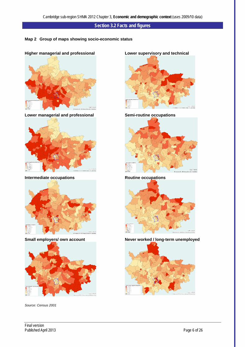
Map 2 Group of maps showing socio-economic status
Higher managerial and professional
Lower supervisory and technical
Lower managerial and professional
Semi-routine occupations
Intermediate occupations
Routine occupations
Small employers/ own account
Never worked / long-term unemployed
Source: Census 2001

Cambridge sub-region SHMA 2012 Chapter 3, Economic and demographic context (uses 2009/10 data)
Section 3.2 Facts and figures
Final version Published April 2013 Page 7 of 26
3.2.4 Claimant unemployment
Table 1: shows unemployment claimant rates in the working age population, for the sub-regional districts, the East of England and England, for each quarter (three month period) from January to March 2008, to April to June 2010.
Table 1: Working age unemployment, Jan 2008 to June 2010
Cambridge East
Cambs Fenland
Huntingdon-shire
South Cambs
Forest Heath
St Edmunds-
bury
East of England
England
Jan-Mar 2008 1.4% 1.0% 2.1% 1.1% 0.8% 1.0% 1.4% 1.7% 2.2%
Apr-Jun 2008 1.3% 1.0% 2.2% 1.1% 0.7% 1.1% 1.5% 1.7% 2.2%
Jul-Sept 2008 1.2% 1.1% 2.3% 1.2% 0.8% 1.0% 1.6% 1.7% 2.3%
Oct-Dec 2008 1.3% 1.3% 2.4% 1.4% 1.0% 1.4% 1.7% 2.0% 2.5%
Jan-Mar 2009 1.7% 2.0% 3.4% 2.2% 1.4% 2.0% 2.6% 2.8% 3.4%
Apr-Jun 2009 2.2% 2.5% 4.2% 2.9% 2.0% 2.7% 3.3% 3.5% 4.1%
Jul-Sept 2009 2.2% 2.4% 4.0% 2.8% 1.9% 2.5% 3.0% 3.4% 4.1%
Oct-Dec 2009 2.2% 2.4% 4.1% 2.6% 1.8% 2.3% 2.8% 3.4% 4.1%
Jan-Mar 2010 2.1% 2.4% 4.4% 2.7% 1.9% 2.6% 2.8% 3.6% 4.3%
Apr-Jun 2010 2.1% 2.4% 4.2% 2.6% 1.7% 2.4% 2.6% 3.4% 4.1% Source: Office of National Statistics, data for Jan 2008 to Jun 2010, last updated Jul 2010
Fig 1: and Fig 2: show this same data graphically…
Fig 1: Sub-regional district unemployment rates
Source: Office of National Statistics, data for Jan 2008 to Jun 2010, last updated Jul 2010
Fig 2: Unemployment rates for East of England and England
Source: Office of National Statistics, data for Jan 2008 to Jun 2010, last updated Jul 2010
Fig 1: and Fig 2: show similar trend lines, with unemployment rates rising significantly from Oct-Dec 2008 to Apr-Jun 2009, steadying till Oct-Dec 2009, rising to Jan-Mar 2010 then dropping to Apr-Jun 2010.
Although the degree of change varies by district, this pattern seems to occur for all lines on the two graphs above, broadly. Within the sub-region Fenland consistently has highest percentage claimant rate and South Cambridgeshire the lowest.

Cambridge sub-region SHMA 2012 Chapter 3, Economic and demographic context (uses 2009/10 data)
Section 3.2 Facts and figures
Final version Published April 2013 Page 8 of 26
3.2.5 Cambridgeshire’s functional economic area: 2011 assessment
Cambridgeshire’s labour market is relatively self contained, with 80% of Cambridgeshire’s residents working in the county, and 81% of Cambridgeshire’s workers living in the county. These figures have not changed significantly since 2001, however there has been a slight increase in the number of residents commuting to London, mainly from South Cambridgeshire and Huntingdonshire.
Cambridge acts as a regional centre of employment. Commuting patterns into Cambridge stretch across the Cambridgeshire local authority boundary into the surrounding districts of St Edmundsbury, Forest Heath and Uttlesford. These patterns overlap significantly with those of Peterborough.
Analysis has therefore been undertaken at the level of the functional economic area (Greater Cambridge), county and district with comparisons taken at regional and national level. The full assessment is available at http://www.cambridgeshire.gov.uk/business/economicandcommunitydev/ecodevelopment/economicassessment.htm
3.2.6 Overview of the Cambridgeshire economy
Cambridgeshire has a diverse, relatively resilient economy with nationally significant strengths in research and development, higher education, software consultancy, high value engineering and manufacturing, creative industries, pharmaceuticals, agriculture, processing and tourism. Many of these sectors are recognised to have significant growth potential which bodes well for the future health of the economy.
Much of the resident population is highly skilled, levels of economic activity are high, crime levels are low and generally residents are satisfied with the area as a place to live. However, the gap in prosperity and skills between the north of the county and the south of the county is growing; women earn significantly less than men and transport congestion costs businesses millions in lost productivity.
Low housing affordability and inadequate broadband access may severely restrict the capacity of the economy to grow. High carbon emissions will increase the vulnerability of business and residents to future hikes in energy prices. Table 2: shows the percentage of the economy in each district attributed to seven major economic classifications.
Table 2: NOMIS ABI 2008 Economic Profile
Cambridge East
Cambridgeshire Fenland HuntingdonshireSouth
Cambridgeshire Forest Heath St
Edmundsbury
1 Manufacturing 4.2% 12.5% 17.7% 13.7% 17.1% 11.8% 16.8%
2 Construction 1.7% 7.4% 5.2% 4.4% 5.2% 5.6% 4.6%
3 Distribution 17.8% 21.0% 26.1% 22.3% 22.5% 28.1% 25.9%
4 Transport 3.2% 8.0% 5.1% 4.9% 1.9% 3.3% 3.3%
5 Finance 25.5% 17.9% 15.8% 18.7% 27.1% 15.9% 13.2%
6 Public Admin 43.5% 20.1% 21.6% 30.0% 20.1% 19.2% 29.2%
7 Other 3.8% 6.1% 3.3% 3.5% 3.5% 12.0% 4.4%
Source: NOMIS ABI 2008 Economic Profile
These data are used to provide background to our assessment of St Edmundsbury and Forest Heaths’s in-migrant / natural growth demographic trends, described in section 3.2.11. The high proportion of people employed in "other" sectors in Forest Heath (12%) includes people employed in the horseracing industry.

Cambridge sub-region SHMA 2012 Chapter 3, Economic and demographic context (uses 2009/10 data)
Section 3.2 Facts and figures
Final version Published April 2013 Page 9 of 26
Table 2:and Fig 3: show that by comparing types of employment in the two Suffolk districts, the profile is similar to the rest of rural Cambridgeshire, excluding Cambridge itself which has a very different economic profile.
Fig 3: NOMIS ABI 2008 Economic Profile
3.2.7 The recession
Although the Cambridgeshire economic assessment used the latest available data, the latest data in some instances was from 2008. Where possible trend data was used to gain a “direction of travel” rather than rely on a snapshot in time, however it is important to recognise that the UK was still in recession in 2008 and over late 2009 and 2010 was only just beginning its slow recovery. The full impact of the recession is therefore unlikely to be identified in this assessment, although some impacts such as a widening gap between stronger and weaker economies can already be seen.
Various organisations have modelled the longer term impact of the recession and recovery and their findings include the following:
The recovery may make the gap between stronger and weaker economies even worse as it is anticipated that growth over the next ten years will be driven by knowledge-based industries such as the creative industries, manu-services, low carbon industries and high-tech and high-value added services.
This would imply that the gap we already see, particularly between the north and south of our functional economic area, is likely to widen.
Cities whose economies are dominated by the public sector are expected to face challenges across all sectors, public and private. The Work Foundation argue that although Cambridge has a high proportion of public sector jobs, the higher value nature of that employment means that the city is still likely to have robust growth in the future. However, Cambridge will not emerge unscathed. The Local Futures Group estimate that around 3,500 to 4,000 jobs will be lost from the public sector between 2010 an 2016. The high level of commuting into Cambridge from surrounding districts means that the impact of these job losses will be felt across a wider area.

Cambridge sub-region SHMA 2012 Chapter 3, Economic and demographic context (uses 2009/10 data)
Section 3.2 Facts and figures
Final version Published April 2013 Page 10 of 26
The multiplier effect of reduced employment in public services will spread out to the wider local economies. Public sector contracts will reduce in value and number while demand for locally produced goods and services, both from the public sector itself and public sector workers via consumption economies, will be affected. Research by Oxford Economics shows that at least 2.3m private sector jobs will be at risk, as a result of the spending cuts. This comprises 1.2m jobs directly supported by the sector and a further 1.1m jobs that depend on the supply chain of these companies.
Cambridge start-ups have traditionally attracted a large proportion of the UK’s venture capital funding, however the availability of that funding has significantly reduced during the course of the recession with many venture capitalists moving out of the risky ‘early stage’ market. The impact of this can be seen on 2008 start-up figures, whether this trend continues remains to be seen.
3.2.8 Implications for future economic strategy
Target training and skills support for business
o Managerial training o Apprenticeships and Group Training Associations
Maximise labor market potential
o Aspirations and skills levels of the long term workless population and deprived communities
o Availability, accessibility and quality of education for 14-19 and adults in rural areas o Links between high skilled graduates and the local business community, and between
schools and local business community o Disparity in earnings between men and women, particularly in South Cambridgeshire o Re-training for public sector workers
Improve strategic and local transport links, broadband infrastructure, housing affordability and enhance quality of life
o Alternative funding streams and approaches to infrastructure improvements o Affordable housing, in all districts, of all sizes. o Resource efficiency, particularly in housing to help tackle fuel poverty o Traffic congestion
Maintain and build strengths in growth sectors
o Inward investment to strengthen supply chains in high growth sectors o Export potential o Adequate provision of appropriately placed land and quality business accommodation o Funding availability o Investment in innovation o Migrant workers – visa restrictions
Build strengths in high value manufacturing and processing
o Renewable energy capacity and associated supply chains o Recruitment of high skilled technicians and managers in to agri-business sector o Tech transfer into agri-business sector o Agriculture susceptibility to climate change
Town centre vitality and tourism – diversify rural economies
o Adequate provision of retail and office accommodation in market towns o Tourism marketing and accommodation o Start-up support

Cambridge sub-region SHMA 2012 Chapter 3, Economic and demographic context (uses 2009/10 data)
Section 3.2 Facts and figures
Final version Published April 2013 Page 11 of 26
Table 3: summarises key findings into Strengths, Weaknesses, Opportunities and Threats, highlighting housing issues (underlined), while taking into consideration what further impacts of the recession we might see on the local economy.
Table 3: Overall SWOT analysis for our economy
Strengths High resident satisfaction (from 2008 Place Survey) Crime levels decreasing - risk of crime a significant factor
in choice of location for businesses Retail growth in all district town centres apart from
Fenland Steady increase in renewable energy capacity High business density across most of the area,
Increasing 2001 to 2008 (apart from Forest Heath) Internationally significant hi-tech sector, increasing hi-
tech firm size 2006 to 2008 Cambridgeshire job growth broadly matches national
rate. Continued employment growth forecast. GVA per capita above regional and national average. Pharmaceutical industry: high value exports. High % of residents employed in high value occupations High skills levels in the south and west of the county A relatively resilient and diverse economy Unemployment claimants increased at a rate equal to or
lower than the national average since onset of recession.
Weaknesses Gap in prosperity and skills between north and south.
Pay gap increasing; currently about 50%. Low levels of resident satisfaction and prosperity in
Fenland and Forest Heath. Housing less affordable than across the region. Reduces
moves in to live, work or set up business. Accessibility of employment, education and training by
means other than car low for rural districts Transport infrastructure and congestion means lost
business productivity, reduced attractiveness as business location and less attractive for investment
Low turnover and employment per enterprise Higher than the national average pay gap2 High, rising disability and Incapacity Benefit claimants in
Fenland. Pockets of long term claimants in Cambridge Minority groups3 face barriers to work and learning Basic & intermediate skills levels poor in Fenland and
Forest Heath4. Increasing employment inequalities: over-representation
of 18-24 year olds among unemployed, esp. in Fenland
Opportunities Significant increase in new homes built that are
affordable. Opportunities for first time buyers and people moving in, increasing labour supply for local businesses.
Further housing developments in the pipeline, increasing potential supply of affordable housing
Micro-generation and increasing renewable energy capacity opens up new supply chain opportunities, increases energy security, reduces fuel poverty
Improving green infrastructure, sports facilities, arts and culture help attract / retain best talent and business
Higher skilled workers commute into Fenland to work, suggests opportunity to up-skill residents to compete.
High-tech sector generating national strengths in creative industries and clean technologies
Targeted managerial training for potential high growth companies supports growth in small businesses.
Opportunities for workless to access jobs due to decreased competition from an ageing population
Potential of labour market supply (36,000 workless individuals in addition to high skilled graduates) not fully realised
Recent increase in further education/apprenticeship take-up of engineering, science and technology.
Short /medium term skills demand in health, retail, business services. Longer term demand in health, creative industries, agriculture, manufacturing.
Strong culture of collaborative working. Structures in place to allow interaction of public, private and social sectors; important in development of public and social capital. Opportunities to build on these structures to maximise potential of the economy, particularly building links between the private and social sectors.
Threats Low attainment and attendance levels of young people in
education in Fenland and Forest Heath5. Dependence on high skilled migrant workers in high tech
and health sectors a threat as visa restrictions tighten. Lower skilled migrant workers returning to country of
origin causes problems for e.g. agriculture & horticulture Lower than average % of population holds level 3 as
highest qualification. Likely chronic intermediate level skills shortage in technical and skilled trades
Managerial and commercial skills in short supply across ICT sector and agri-food industry; may restrict growth.
Reduction of occupied office space in town centres reduces business diversity; implications for growth.
Lack of available venture capital could constrain birth and growth of high value, high technology businesses.
CO2 emissions per head higher than average; could cause problems as fuel prices increase.
Food, farming and transport industries susceptible to negative impacts of climate change
High public sector employment in Cambridge & high in-commuting means high impact of redundancies.
Some economies6 lack diversity and business ‘churn’ and depend on low value manufacturing and processing.
Birth rates of new enterprises low; decreased in 2008. Can reduce competition and restrict business innovation
Few affordable detached and semi-detached homes available in Cambridge; deter inward investors who need to move to the city with staff and families
Strong innovation performance constrained by linkages e.g. transport and cost of finance.
Future population growth patterns likely to compound differences in prosperity between the south and north
Housing stock condition relatively poor in places7. Reduces attractiveness as places to live and invest.
Access to next generation broadband unlikely for much of county: affects business productivity, ability to work from home and attractiveness for inward investment
2 Average pay gap is about 30% between men and women across most of the area. National gap is 20%. 3 Including Travellers 4 Also pockets of education deprivation in Huntingdon, St Neots and Cambridge. 5 Accessibility of education is low particularly in Fenland. 6 Specifically East Cambridgeshire, Fenland, St Edmundsbury and Forest Heath
Cambridge sub-region SHMA 2012 Chapter 3, Economic and demographic context (uses 2009/10 data)
Section 3.2 Facts and figures
Final version Published April 2013 Page 12 of 26
3.2.9 Demography: looking back 1991 to 2001
There are two sources of information on population change between 1991 and 2001. The first is the national Census and the second is the mid-year population estimates series produced by the Office for National Statistics (ONS). Table 4: compares Census data on the population living in the districts in the housing sub-region for 1991 and 2001.
Table 4: Resident Population 1991 and 2001
1991 2001 Change 1991 to 2001
% change % of 2001 population
Cambridge City 101,643 108,863 7,220 7.1 15.4
East Cambridgeshire 59,477 73,214 13,737 23.1 10.4
Fenland 73,217 83,519 10,302 14.1 11.8
Huntingdonshire 141,008 156,954 15,946 11.3 22.2
South Cambridgeshire 118,692 130,108 11,416 9.6 18.4
Forest Heath 54,834 55,510 676 1.2 7.9
St Edmundsbury 91,731 98,193 6,462 7.0 13.9
Cambridge sub-region 640,602 706,361 65,759 10.3 100.0
Source: Census 1991 and 2001
The 2001 Census aimed to provide a ‘One Number’ estimate of the total resident population, grossing up to account for non-response. The 1991 Census made some allowances to account for households who were known to exist, but who failed to return a fully completed Census form. The consequence is that the 1991 Census under-recorded the population in some areas. This also means that the change 1991 to 2001 is likely to be an over-estimate. In 1991 students were counted at their home, rather than their term-time address. So although students were counted, they do not appear in the same way they appear in the 2001 Census.
The Census results suggest that the sub-region’s population increased by almost 65,800 or 10%. Huntingdonshire experienced the highest growth in terms of numbers, with an additional 16,000 people recorded in 2001 as compared with 1991. East Cambridgeshire also experienced very high population growth of over 13,700 – although there is some concern here that the 2001 Census calculations actually over-estimate the true numbers. Mid year population estimates produced by ONS for 1991 and 2001 resulted in a different profile, as Table 5: shows.
Table 5: Mid Year Population Estimates for 1991 & 2001, ‘000
1991 2001 Change 1991 to 2001 % change
Cambridge City 106.7 110.1 3.4 3.2
East Cambridgeshire 60.9 73.4 12.5 20.5
Fenland 75.1 83.7 8.6 11.5
Huntingdonshire 146.1 157.2 11.1 7.6
South Cambridgeshire 121.9 130.5 8.6 7.1
Forest Heath 57.7 56.2 - 1.5 - 2.6
St Edmundsbury 92.5 98.3 5.8 6.3
Cambridge sub-region 660.9 709.4 48.5 7.3
Source: ONS
7 e.g. Littleport, St Ives, parts of Forest Heath and Wisbech
Cambridge sub-region SHMA 2012 Chapter 3, Economic and demographic context (uses 2009/10 data)
Section 3.2 Facts and figures
Final version Published April 2013 Page 13 of 26
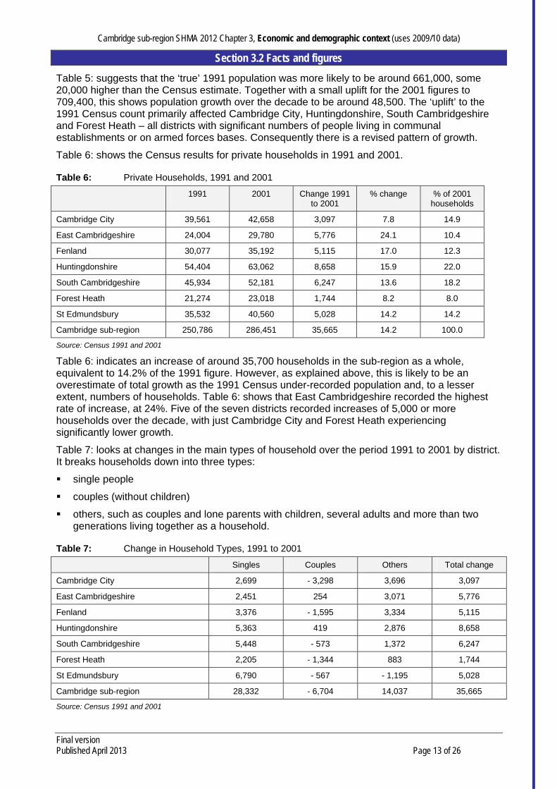
Table 5: suggests that the ‘true’ 1991 population was more likely to be around 661,000, some 20,000 higher than the Census estimate. Together with a small uplift for the 2001 figures to 709,400, this shows population growth over the decade to be around 48,500. The ‘uplift’ to the 1991 Census count primarily affected Cambridge City, Huntingdonshire, South Cambridgeshire and Forest Heath – all districts with significant numbers of people living in communal establishments or on armed forces bases. Consequently there is a revised pattern of growth.
Table 6: shows the Census results for private households in 1991 and 2001.
Table 6: Private Households, 1991 and 2001
1991 2001 Change 1991 to 2001
% change % of 2001 households
Cambridge City 39,561 42,658 3,097 7.8 14.9
East Cambridgeshire 24,004 29,780 5,776 24.1 10.4
Fenland 30,077 35,192 5,115 17.0 12.3
Huntingdonshire 54,404 63,062 8,658 15.9 22.0
South Cambridgeshire 45,934 52,181 6,247 13.6 18.2
Forest Heath 21,274 23,018 1,744 8.2 8.0
St Edmundsbury 35,532 40,560 5,028 14.2 14.2
Cambridge sub-region 250,786 286,451 35,665 14.2 100.0
Source: Census 1991 and 2001
Table 6: indicates an increase of around 35,700 households in the sub-region as a whole, equivalent to 14.2% of the 1991 figure. However, as explained above, this is likely to be an overestimate of total growth as the 1991 Census under-recorded population and, to a lesser extent, numbers of households. Table 6: shows that East Cambridgeshire recorded the highest rate of increase, at 24%. Five of the seven districts recorded increases of 5,000 or more households over the decade, with just Cambridge City and Forest Heath experiencing significantly lower growth.
Table 7: looks at changes in the main types of household over the period 1991 to 2001 by district. It breaks households down into three types:
single people
couples (without children)
others, such as couples and lone parents with children, several adults and more than two generations living together as a household.
Table 7: Change in Household Types, 1991 to 2001
Singles Couples Others Total change
Cambridge City 2,699 - 3,298 3,696 3,097
East Cambridgeshire 2,451 254 3,071 5,776
Fenland 3,376 - 1,595 3,334 5,115
Huntingdonshire 5,363 419 2,876 8,658
South Cambridgeshire 5,448 - 573 1,372 6,247
Forest Heath 2,205 - 1,344 883 1,744
St Edmundsbury 6,790 - 567 - 1,195 5,028
Cambridge sub-region 28,332 - 6,704 14,037 35,665
Source: Census 1991 and 2001

Cambridge sub-region SHMA 2012 Chapter 3, Economic and demographic context (uses 2009/10 data)
Section 3.2 Facts and figures
Final version Published April 2013 Page 14 of 26
Table 7: shows that the number of couples (all without children), decreased in virtually every district apart from those experiencing high rates of household growth overall. The number of households composed of single people increased by over 28,000 over the decade across the sub-region as a whole. There was also growth in the number of ‘other’ households, increasing by just over 14,000. This category includes single parent households, couples with children and other households, both with and without children.
Initial 2011 Census results were published in July 2012, which will be used to update this data in our next SHMA.
3.2.10 Current demography: district profiles
The following section provides key highlights on the current demography of each district in our sub-region.
Cambridge
The Cambridgeshire County Council Research Group (CCCRG) mid-2009 population estimate for Cambridge City is 119,100. The population has increased by 8% since 2001 and is forecast to increase by a further 28% by 2031.
In 2009 Cambridge had the highest proportion of its population aged 16-24 and 25-39 of all the districts. This is due to the large student population at Anglia Ruskin University and the University of Cambridge, which has a significant ‘distorting’ effect on the district’s overall age structure.
CCCRG estimates the number of households in 2009 as 46,000. This represents 8% household growth since 2001 and is forecast to increase by a further 33% by 2031.
Some 75% of Cambridge’s population aged 16-64 is economically active.
In December 2010 the Jobseeker’s Allowance claimant count unemployment rate was almost 2% compared to a national level of 3.5%.
Life expectancy at birth is higher in Cambridge than in England but the difference is statistically significant only for females. Females are expected to live 5 years longer than men.
Cambridge City has higher levels of overall mortality compared to Cambridgeshire. The most common causes of premature deaths are circulatory diseases and cancer.
East Cambridgeshire
The Cambridgeshire County Council Research Group (CCCRG) mid-2009 population estimate for East Cambridgeshire is 80,300. The population has increased by 13% since 2001 and is forecast to increase by a further 22% by 2031.
In 2009 the largest population age band is people aged 40-64, which constitutes 35% of East Cambridgeshire’s population. By 2031 it is forecast to decline to 30% of total population, with significant growth in the 65-74 and 75+ age groups.
CCCRG estimates the number of households in 2009 as 34,800. This represents 16% growth since 2001 and is forecast to increase by a further 30% by 2031.
86% of East Cambridgeshire’s working age population is economically active.
In December 2010 the Jobseekers’ Allowance claimant count unemployment rate was almost 2% compared to a national level of 3.5%.
Life expectancy at birth is higher in East Cambridgeshire than in England. Females are expected to live 3 years longer than men.
East Cambridgeshire has lower levels of overall mortality compared to Cambridgeshire. The most common causes of premature deaths are circulatory diseases and cancer.
Cambridge sub-region SHMA 2012 Chapter 3, Economic and demographic context (uses 2009/10 data)
Section 3.2 Facts and figures
Final version Published April 2013 Page 15 of 26
Fenland
The Cambridgeshire County Council Research Group (CCCRG) mid-2009 population estimate for Fenland is 93,300. The population has increased by 12% since 2001 and it is forecast to increase by a further 21% by 2031.
In 2009 the largest population age band is people aged 40-64, which constitutes 34% of Fenland’s population. By 2031 it is forecast to decline to 29% of total population, with significant growth in the 65-74 and 75+ age groups.
CCCRG estimates the number of households in 2009 as 39,900. This represents 13% growth since 2001. Households are forecast to increase by a further 28% by 2031.
77% of Fenland’s working age population is economically active.
In December 2010 the Jobseekers’ Allowance claimant count unemployment rate was slightly lower than the national level of 3.5%.
Life expectancy at birth is lower in Fenland than in England but the difference is only statistically significant for males. Females are expected to live 5 years longer than men.
Fenland has the highest levels of overall mortality in Cambridgeshire. The most common causes of premature deaths are circulatory diseases and cancer.
Huntingdonshire
The Cambridgeshire County Council Research Group (CCCRG) mid-2009 population estimate for Huntingdonshire is 164,600. The population has increased by 5% since 2001 and it is forecast to increase by a further 7% by 2031.
In 2009 Huntingdonshire has the highest proportion of its residents aged 40-64 of all the districts. In future, its age structure is forecast to age, with all age groups younger than 64 decreasing as proportions of total population and all older age groups increasing.
CCCRG estimates the number of households in 2009 as 69,300. This represents 10% growth since 2001 and is forecast to increase by a further 18% by 2031.
80% of Huntingdonshire’s working age population is economically active. In December 2010 the Jobseekers’ Allowance claimant count unemployment rate was 2% compared to a national level of 3.5%.
Life expectancy at birth is higher in Huntingdonshire than in England. The difference is statistically significant for both males and females. Females are expected to live 4 years longer than men.
Huntingdonshire has the third lowest levels of overall mortality in Cambridgeshire. The most common causes of premature deaths are circulatory diseases and cancer.
South Cambridgeshire
The Cambridgeshire County Council Research Group (CCCRG) mid-2009 population estimate for South Cambridgeshire is 143,600. The population has increased by 10% since 2001 and it is forecast to increase by a further 27% by 2031.
Most of the population is in the 25-39 and 40-64 age bands. The population’s age structure is likely to age over the next 22 years.
CCCRG estimates the number of households in 2009 as 59,800. This represents 14% growth since 2001 and is forecast to increase by a further 35% by 2031.
84% of South Cambridgeshire’s working age population is economically active. In December 2010 the Jobseekers’ Allowance claimant count unemployment rate was almost 1.5% compared to a national level of 3.5%.

Cambridge sub-region SHMA 2012 Chapter 3, Economic and demographic context (uses 2009/10 data)
Section 3.2 Facts and figures
Final version Published April 2013 Page 16 of 26
Life expectancy at birth is higher in South Cambridgeshire than in England. The difference is statistically significant for both males and females. Females are expected to live 3 years longer than men.
South Cambridgeshire has the lowest levels of overall mortality in Cambridgeshire. The most common causes of premature deaths are circulatory diseases and cancer.
Link to profiles: http://map1.cambridgeshire.gov.uk/observe/Flash/Profiles/WardProfiles/atlas.html
Forest Heath
Forest Heath is in West Suffolk, next to the boundaries of Norfolk and Cambridgeshire. It is a predominantly rural area with three market towns, Newmarket, Mildenhall and Brandon and a number of villages and small hamlets. The district has good connections to London and Norwich along the A11 and to the Midlands, Ipswich and the Port of Felixstowe along the A14.
The district, which has an area of 380 km2 (144 square miles) has a rich variety of natural landscape from the chalk downlands of Newmarket, through the rich agricultural fenlands in the west, to the sandy Brecklands in the north, home to the largest 'lowland' forest in the country.
In June 2010, the population of Forest Heath was 64,300 made up of 28,240 households. These figures suggest that Forest Heath has grown by nearly 12% over the last eight years, making it the fastest growing district in Suffolk, the fifth fastest in the eastern region and the 12th fastest nationally. Whilst the population is ageing, the district has a more youthful profile than the rest of the region, with almost two thirds of the population being working age (15-64) and only 5% aged 65 or over.
Forest Heath is the most ethnically diverse district in Suffolk (13.2% of the population was non-white in June 2009, compared to the national average of 12.5%) and has the largest foreign population in the county. The 2009 Annual Population Survey suggested that over 15% of the population are non-UK nationals, compared to a Suffolk average of 4.2%.
The district's diversity and youthful age profile can be attributed to the presence of the United States Air Force in Europe (USAFE) bases in Mildenhall and Lakenheath and the number of migrant workers in the district's horse racing and agricultural industries.
Source: http://www.forest-heath.gov.uk/info/100004/council_and_democracy/526/about_the_district
St Edmundsbury
St Edmundsbury is located in western Suffolk. The borough has borders with Norfolk and Breckland district to the north, Mid Suffolk and Babergh districts to the south and east, Essex and Braintree district to the south and Cambridgeshire and South and East Cambridgeshire districts and Forest Heath district to the west. While administratively links are with Suffolk County Council, the borough is increasingly playing a stronger role in the sub-region of Cambridge due to common economic and social needs.
The borough of St Edmundsbury is a predominantly rural area covering nearly 660 square kilometres and comprising over 70 towns and villages ranging in size from a few residents to the historic market town of Bury St Edmunds with a 2001 population of 35,222.The estimated resident population of the borough in mid 2008 was 103,700, representing a growth of 13.4% since 1987.
Bury St Edmunds
Bury St Edmunds plays an important role in the regional economy. As the former county town for West Suffolk it still acts as a sub-regional employment and service centre serving a wide, largely rural hinterland. It is well placed to benefit from further growth as part of the A14 Cambridge to Ipswich corridor, but this needs to be managed in the context of the town’s historic built environment, the rural landscape and the local distinctiveness of surrounding villages. The former Cattle Market site has been redeveloped as a mixed use scheme with retail, residential and a major new public venue. The ‘arc’ shopping centre which forms part of this redevelopment

Cambridge sub-region SHMA 2012 Chapter 3, Economic and demographic context (uses 2009/10 data)
Section 3.2 Facts and figures
Final version Published April 2013 Page 17 of 26
opened in March 2009, has seen a significant increase in available retail floor space, ensuring the return of shoppers to the town from other shopping destinations.
Haverhill
Located at the south-western corner of the borough, Haverhill is the borough’s second town and the fifth largest in Suffolk. It is a market town located within the Cambridge sub-region and currently has a population of around 22,000. The town experienced considerable housing and economic growth since the 1960’s, but it is fair to say that the town centre infrastructure had not kept pace with this growth and the Borough Council invested significant resources into the delivery of a regeneration masterplan for the central area. Haverhill is, however, well positioned to play a significant role in accommodating some of the additional development planned for the sub-region as well as potentially benefiting from the proximity of Stansted Airport and the M11. However, it is important that any such growth provides a balance of homes, jobs and improvements to services including health and shopping facilities.
Rural
Approximately 43% of the population of St Edmundsbury live in the 18 rural wards in the borough. Access to jobs and services, including public transport, is a particular issue in these areas, especially for the smaller villages. The ability for local people to find housing in their own area is also a major concern. Nearly 25% of the rural population is aged over 65. Many parishes in our rural areas lack essential services. For example 73% do not have a food shop or general store and 74% do not have a post office. However 58% have a public house and 64% have a village hall or community centre. Whilst the two towns of Bury St Edmunds and Haverhill will provide the main focus for large scale growth in the borough, a high proportion of the new housing an employment development will be located in rural areas, in those villages which have a range of services and facilities to meet local needs.
Source:
http://www.stedmundsbury.gov.uk/sebc/live/documents/reports/B143%20Approval%20of%20Local%20Investment%20Plan.pdf
3.2.11 Demographic data used to calculate affordable housing need
The tables below provide information used in our calculation of affordable housing need in Chapter 13. Table 8: presents the CLG household projections, using 2008 and 2013 figures to work back to a 2010 figure for our affordable housing calculation based on 2009/10 data.
Table 8: CLG household projections by district
2008 households 2013 projected households
Calculation of 2010 households8
Cambridge City 45,000 47,000 45,800
East Cambridgeshire 34,000 37,000 35,200
Fenland 39,000 43,000 40,600
Huntingdonshire 69,000 73,000 70,600
South Cambridgeshire 58,000 63,000 60,000
Forest Heath 25,000 27,000 25,800
St Edmundsbury 44,000 46,000 44,800
Cambridge sub-region 314,000 336,000 322,800
Source: CLG Table 406, at http://www.communities.gov.uk/documents/housing/xls/140987.xls
8 2010 calculated as number of households in 2008 x 40% (or 2008 plus 2 years)
Cambridge sub-region SHMA 2012 Chapter 3, Economic and demographic context (uses 2009/10 data)
Section 3.2 Facts and figures
Final version Published April 2013 Page 18 of 26
Table 9: sets out more detailed household estimates, and the division of growth in households into two main categories: “natural growth” which comes from the current resident population of the area; and “in-migrant” growth which is due to households moving into the district in question – from a neighbouring district, county, from across the UK or elsewhere. Both are vital to our understanding of local communities and economies, and movement of people for work and other reasons.
Table 9: Using household figures to identify annual natural growth and in-migrant growth
Households 2008
Households 2013
Change 2008 to
2013
Average change per
year
Natural growth per
year to 2011
In-migrants per year to
2011
Cambridge City 45,200 50,700 5,500 1,100 440 660
East Cambridgeshire 34,300 35,400 1,100 220 320 -100
Fenland 39,500 41,400 1,900 380 280 100
Huntingdonshire 68,400 71,900 3,500 700 760 -60
South Cambridgeshire 59,000 62,500 3,500 700 780 -80
Forest Heath 23,642 26,958 3,315 663 728 -65
St Edmundsbury 42,530 45,750 3,220 644 707 -63
Table 10: Percentage of total growth per year due to natural growth and to in-migration, rural Cambridgeshire districts
East
Cambridgeshire Fenland Huntingdonshire
South
Cambridgeshire Average
Natural growth 145% 74% 109% 111% 110%
In-migrants -45% 26% -9% -11% -10%
3.2.12 A note about natural growth and in-migration in Suffolk
Cambridgeshire County Council produces household estimates for Cambridgeshire districts where it is possible to establish growth from in-migration and natural growth. While overall estimates of household growth are available for the Suffolk districts, there are currently no comparable data about natural growth and in-migration for Forest Heath and St Edmundsbury. Household growth estimates are used in the calculation of newly arising need. As in-migrants and existing households are treated differently in this part of the calculation some estimate of the split was required. As household growth and migration are to a large extent influenced by economic factors, we compared an economic profile of the rural Cambridgeshire districts with the Suffolk districts (see section 3.2.6 above) and found them to be broadly similar. Therefore the split of growth from in-migration versus natural growth for Forest Heath and St Edmundsbury was based on the overall split of the Cambridgeshire rural districts.
3.2.13 Land-use planning context
Previously, the main driver for future population and household growth in the Cambridge sub-region was the 2003 Cambridgeshire & Peterborough Structure Plan. The policies of the Structure Plan aim to accommodate substantial growth in the immediate Cambridge area, significantly above that generated by ‘natural change’. The previous SHMA produced in 2010 sets out in full the approach to new development and the land-use planning context for this, and is available at www.cambridgeshire.horizons.co.uk/shma
Further information on the land-use planning context and the work of the new Joint Strategic Planning Unit, mentioned in section 3.2.2, is outlined in Chapter 11, Planning and land availability.

Cambridge sub-region SHMA 2012 Chapter 3, Economic and demographic context (uses 2009/10 data)
Section 3.3 Analysis
Final version Published April 2013 Page 19 of 26
3.3 Analysis
3.3.1 Our economic context
The Cambridge functional economic area (which covers the whole housing sub-region) continues to thrive, both nationally and internationally. The labour market is fairly self-contained, with Cambridge acting as a regional centre of employment. It is a diverse economy with some significant stengths, but some weaknesses too.
Housing is both a positive and a negative force within our economy. This edition of the SHMA, based on 2009/10 data, reflects the economic situation at that time, so cannot reflect the full impact of the recession.
3.3.2 Our demographic context
Cambridge’s population and number of households continue to grow and area predicted to grow further to 2031. Cambridge includes a large student population, so it shows a larger than usual proportion aged between 16 and 39. Some 75% of the population aged 16 to 64 are economically active. Unemployment is low (under 2%).
East Cambridgeshire’s population is growing now, and to 2031. The largest age band is 40-64 at present, and it is forecast that by 2031 there will be a significant increase in the 65 to 74 and 75+ age bands. 86% of the working age population is economically active. Again less than 2% claiming Jopb Seekers Allowance (JSA).
In Fenland the population is increasing, with similar age pattern as East Cambridgeshire. Some 77% of the working age population are economically active. Unemployment at December 2010 was just under the national average of 3.5%.
Huntingdonshire’s population is growing but at a slower rate than other districts. Shows a similar age pattern to other districts, though in Huntingdonshire ONLY the older age groups are predicted to increase in future, all the younger age groups are predicted to decline as a proportion of the population. Some 80% of the working age population is economically active with a 2% claimant count for JSA at December 2010.
South Cambridgeshire sees an increasing population. The largest age groups are 25 to 39 and 40 to 64 years old. Some 84% of the working age population is economically active and there was a 1.5% unemployment count at December 2010.
Forest Heath saw the greatest growth of all the districts in Suffolk, based on June 2010 estimates, at 12% growth. Whilst the population is ageing, the district has a more youthful profile than the rest of the region, with almost two thirds of the population being working age (15-64) and only 5% aged 65 or over. The USAF bases in Mildenhall and Lakenheath have a significant effect on the district’s demography.
St Edmundsbury has a growing population. Saw low unemployment at 3.1% in September 2009. Haverhill is the fastest growing town in Suffolk, but has a relatively high rate of NEETs (not in education, employment or training). Around 43% of the population lives in the rural areas of St Edmundsbury.
3.3.3 Changes over time
Our economy continues to prove resilient though the effects of the 2008 recession are yet to be seen clearly within the SHMA, as this update focuses on 2009/10 data which may not reflect the resulting changes fully.

Cambridge sub-region SHMA 2012 Chapter 3, Economic and demographic context (uses 2009/10 data)
Section 3.3 Analysis
Final version Published April 2013 Page 20 of 26
Our population and number of households across the sub-region continue to increase, partly due to natural growth from our existing residents, partly due to people moving in to our area for economic social and other reasons. Our population (similar to other areas) is generally ageing and this brings with it issues for the housing market and how it will accommodate this huge shift in demographic profile in the medium to longer term.
The affordable need calculation uses “natural growth” and “in-migrant figures” to model the formation and movement of households each year who are in housing need, across our housing sub-region. This chapter sets out the figures used in Chapter 13, Affordable housing need and how the breakdown of household change fits into these two definitions.

Cambridge sub-region SHMA 2012 Chapter 3, Economic and demographic context (uses 2009/10 data)
Section 3.4 Links and references
Final version Published April 2013 Page 21 of 26
3.4 Links and references
Cambridgeshire’s economic assessment (summary) http://www.cambridgeshire.gov.uk/NR/rdonlyres/BF2B205F-30B8-4D78-AEA4-06D4912DE824/0/ExecSummary.pdf
District economic assessments:
o Cambridge http://www.cambridgeshire.gov.uk/NR/rdonlyres/90357D72-0E76-4210-86E6-195C639116C0/0/CambridgeProfile.pdf
o ECDC http://www.cambridgeshire.gov.uk/NR/rdonlyres/77F7D5BA-21DF-403F-A0A6-8134161DA1EB/0/EastCambsProfile.pdf
o FDC http://www.cambridgeshire.gov.uk/NR/rdonlyres/F36E4AD6-0C86-49D1-8F9F-AE4480C8A88C/0/FenlandProfile.pdf
o HDC http://www.cambridgeshire.gov.uk/NR/rdonlyres/3FDE4BFC-96E5-430B-B514-6544F4B587D9/0/HuntingdonshireProfile.pdf
o SCDC http://www.cambridgeshire.gov.uk/NR/rdonlyres/3D5C9CFD-3270-401D-BD2E-2163631AE401/0/SouthCambridgeshire.pdf
o FHDC http://www.cambridgeshire.gov.uk/NR/rdonlyres/5CF7D759-3BB6-4921-8886-0C728A357E1F/0/ForestHeath.pdf
o SEBC http://www.cambridgeshire.gov.uk/NR/rdonlyres/546C846D-4468-480B-AC35-BD5DA45EBD7B/0/StEdsprofile.pdf
District ward profiles
o Cambridgeshire http://map1.cambridgeshire.gov.uk/observe/Flash/Profiles/WardProfiles/atlas.html
o Forest Heath http://www.forest-heath.gov.uk/info/100004/council_and_democracy/526/about_the_district
o St Edmundsbury http://www.stedmundsbury.gov.uk/sebc/live/documents/reports/B143%20Approval%20of%20Local%20Investment%20Plan.pdf

Cambridge sub-region SHMA 2012 Chapter 3, Economic and demographic context (uses 2009/10 data)
Section 3.5 Definitions of terms
Final version Published April 2013 Page 22 of 26
3.5 Definitions of terms
Term used Abbreviation Meaning Link for further information
Cambridge sub-region SHMA 2012 Chapter 3, Economic and demographic context (uses 2009/10 data)
Section 3.6 Data issues
Final version Published April 2013 Page 23 of 26
3.6 Data issues
Main sources of data
o Cambridgeshire ward atlases
o Census 1991
o Census 2001
o CLG household projections table 406
o ONS Jan 2008 to June 2010
o ONS mid-year population estimates
o Cambridge economic area’s functional economic assessment
o NOMIS ABI economic profile 2008
Planned changes to data
o Census 2011 – full results will be published late in 2012 and feed in to the SHMA in future versions
Cambridge sub-region SHMA 2012 Chapter 3, Economic and demographic context (uses 2009/10 data)
Section 3.7 Additional information
Final version Published April 2013 Page 24 of 26
3.7 Additional information
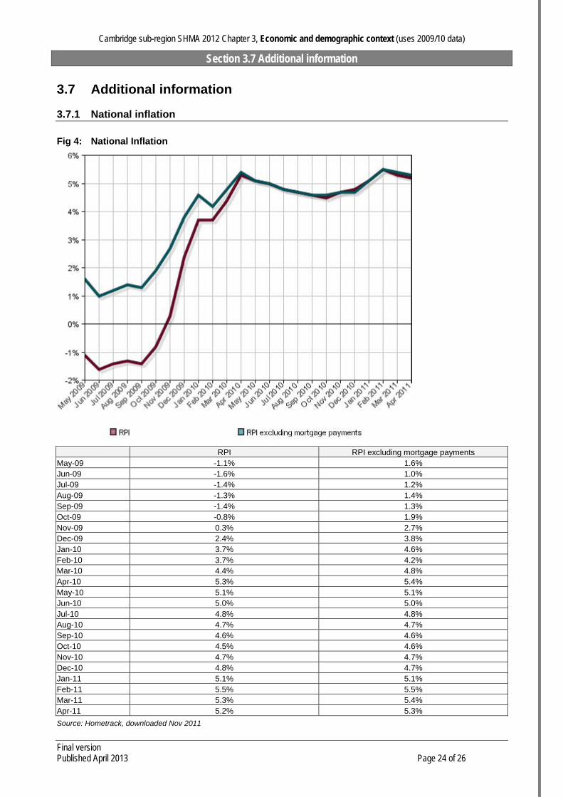
3.7.1 National inflation
Fig 4: National Inflation
RPI RPI excluding mortgage payments May-09 -1.1% 1.6% Jun-09 -1.6% 1.0% Jul-09 -1.4% 1.2% Aug-09 -1.3% 1.4% Sep-09 -1.4% 1.3% Oct-09 -0.8% 1.9% Nov-09 0.3% 2.7% Dec-09 2.4% 3.8% Jan-10 3.7% 4.6% Feb-10 3.7% 4.2% Mar-10 4.4% 4.8% Apr-10 5.3% 5.4% May-10 5.1% 5.1% Jun-10 5.0% 5.0% Jul-10 4.8% 4.8% Aug-10 4.7% 4.7% Sep-10 4.6% 4.6% Oct-10 4.5% 4.6% Nov-10 4.7% 4.7% Dec-10 4.8% 4.7% Jan-11 5.1% 5.1% Feb-11 5.5% 5.5% Mar-11 5.3% 5.4% Apr-11 5.2% 5.3%
Source: Hometrack, downloaded Nov 2011
Cambridge sub-region SHMA 2012 Chapter 3, Economic and demographic context (uses 2009/10 data)
Section 3.7 Additional information
Final version Published April 2013 Page 25 of 26
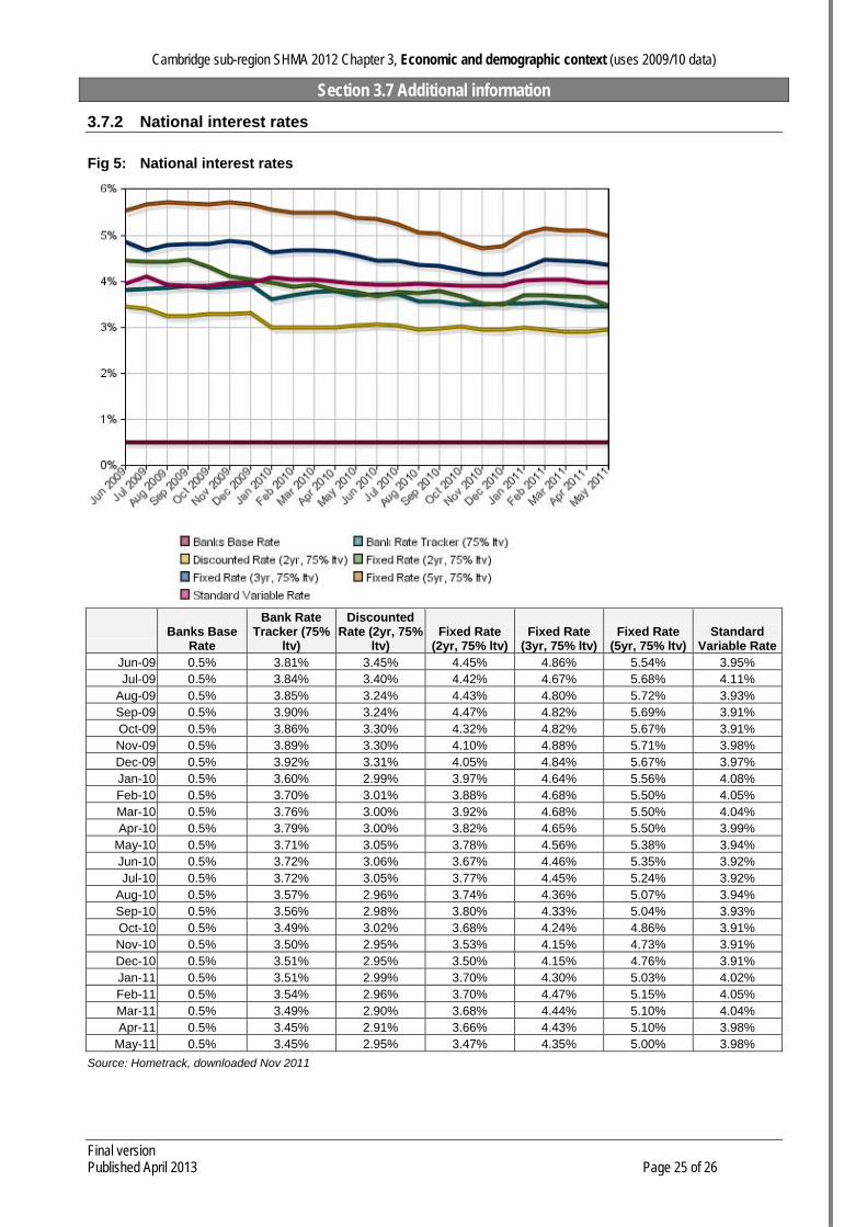
3.7.2 National interest rates
Fig 5: National interest rates
Banks Base
Rate
Bank Rate Tracker (75%
ltv)
Discounted Rate (2yr, 75%
ltv) Fixed Rate
(2yr, 75% ltv)Fixed Rate
(3yr, 75% ltv)Fixed Rate
(5yr, 75% ltv) Standard
Variable RateJun-09 0.5% 3.81% 3.45% 4.45% 4.86% 5.54% 3.95% Jul-09 0.5% 3.84% 3.40% 4.42% 4.67% 5.68% 4.11%
Aug-09 0.5% 3.85% 3.24% 4.43% 4.80% 5.72% 3.93% Sep-09 0.5% 3.90% 3.24% 4.47% 4.82% 5.69% 3.91% Oct-09 0.5% 3.86% 3.30% 4.32% 4.82% 5.67% 3.91% Nov-09 0.5% 3.89% 3.30% 4.10% 4.88% 5.71% 3.98% Dec-09 0.5% 3.92% 3.31% 4.05% 4.84% 5.67% 3.97% Jan-10 0.5% 3.60% 2.99% 3.97% 4.64% 5.56% 4.08% Feb-10 0.5% 3.70% 3.01% 3.88% 4.68% 5.50% 4.05% Mar-10 0.5% 3.76% 3.00% 3.92% 4.68% 5.50% 4.04% Apr-10 0.5% 3.79% 3.00% 3.82% 4.65% 5.50% 3.99%
May-10 0.5% 3.71% 3.05% 3.78% 4.56% 5.38% 3.94% Jun-10 0.5% 3.72% 3.06% 3.67% 4.46% 5.35% 3.92% Jul-10 0.5% 3.72% 3.05% 3.77% 4.45% 5.24% 3.92%
Aug-10 0.5% 3.57% 2.96% 3.74% 4.36% 5.07% 3.94% Sep-10 0.5% 3.56% 2.98% 3.80% 4.33% 5.04% 3.93% Oct-10 0.5% 3.49% 3.02% 3.68% 4.24% 4.86% 3.91% Nov-10 0.5% 3.50% 2.95% 3.53% 4.15% 4.73% 3.91% Dec-10 0.5% 3.51% 2.95% 3.50% 4.15% 4.76% 3.91% Jan-11 0.5% 3.51% 2.99% 3.70% 4.30% 5.03% 4.02% Feb-11 0.5% 3.54% 2.96% 3.70% 4.47% 5.15% 4.05% Mar-11 0.5% 3.49% 2.90% 3.68% 4.44% 5.10% 4.04% Apr-11 0.5% 3.45% 2.91% 3.66% 4.43% 5.10% 3.98%
May-11 0.5% 3.45% 2.95% 3.47% 4.35% 5.00% 3.98%
Source: Hometrack, downloaded Nov 2011

Cambridge sub-region SHMA 2012 Chapter 3, Economic and demographic context (uses 2009/10 data)
Section 3.7 Additional information
Final version Published April 2013 Page 26 of 26
3.7.3 National trends in mortgage lending by type
Fig 6: National trends in mortgage lending by type
Loans for house purchase (£m) Remortgage (£m) Other (£m) May-09 6,797,000,000 4,029,000,000 820,000,000 Jun-09 8,119,000,000 4,635,000,000 941,000,000 Jul-09 8,600,000,000 4,836,000,000 913,000,000 Aug-09 6,910,000,000 3,256,000,000 729,000,000 Sep-09 7,836,000,000 3,273,000,000 898,000,000 Oct-09 7,995,000,000 3,148,000,000 868,000,000 Nov-09 7,514,000,000 3,156,000,000 797,000,000 Dec-09 5,776,000,000 3,025,000,000 583,000,000 Jan-10 3,972,000,000 2,470,000,000 524,000,000 Feb-10 5,493,000,000 3,518,000,000 689,000,000 Mar-10 8,102,000,000 4,388,000,000 817,000,000 Apr-10 7,524,000,000 3,477,000,000 693,000,000 May-10 7,858,000,000 3,477,000,000 694,000,000 Jun-10 8,761,000,000 3,967,000,000 763,000,000 Jul-10 7,991,000,000 3,844,000,000 688,000,000 Aug-10 6,650,000,000 3,444,000,000 656,000,000 Sep-10 6,769,000,000 3,833,000,000 704,000,000 Oct-10 6,646,000,000 3,813,000,000 663,000,000 Nov-10 6,575,000,000 4,566,000,000 645,000,000 Dec-10 4,339,000,000 3,320,000,000 454,000,000 Jan-11 3,563,000,000 3,275,000,000 471,000,000 Feb-11 5,385,000,000 4,752,000,000 585,000,000 Mar-11 7,913,000,000 5,038,000,000 709,000,000 Apr-11 6,510,000,000 3,368,000,000 533,000,000
Source: Hometrack, downloaded Nov 2011