Embed Size (px)
Citation preview

from Perilous Earth: Understanding Processes Behind Natural Disasters, ver. 1.0, June, 2009 by G.H. Girty, Department of Geological Sciences, San Diego State University Page 1
Chapter 2 Volcanoes
from Perilous Earth: Understanding Processes Behind Natural Disasters, ver. 1.0, June, 2009 by G.H. Girty, Department of Geological Sciences, San Diego State University Page 2
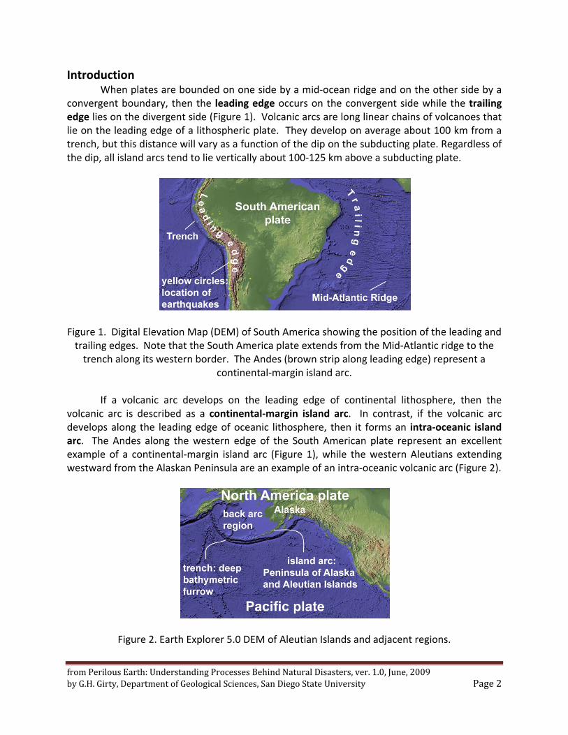
Introduction When plates are bounded on one side by a mid‐ocean ridge and on the other side by a
convergent boundary, then the leading edge occurs on the convergent side while the trailing edge lies on the divergent side (Figure 1). Volcanic arcs are long linear chains of volcanoes that lie on the leading edge of a lithospheric plate. They develop on average about 100 km from a trench, but this distance will vary as a function of the dip on the subducting plate. Regardless of the dip, all island arcs tend to lie vertically about 100‐125 km above a subducting plate.
Figure 1. Digital Elevation Map (DEM) of South America showing the position of the leading and trailing edges. Note that the South America plate extends from the Mid‐Atlantic ridge to the trench along its western border. The Andes (brown strip along leading edge) represent a
continental‐margin island arc.
If a volcanic arc develops on the leading edge of continental lithosphere, then the volcanic arc is described as a continental‐margin island arc. In contrast, if the volcanic arc develops along the leading edge of oceanic lithosphere, then it forms an intra‐oceanic island arc. The Andes along the western edge of the South American plate represent an excellent example of a continental‐margin island arc (Figure 1), while the western Aleutians extending westward from the Alaskan Peninsula are an example of an intra‐oceanic volcanic arc (Figure 2).
Figure 2. Earth Explorer 5.0 DEM of Aleutian Islands and adjacent regions.
from Perilous Earth: Understanding Processes Behind Natural Disasters, ver. 1.0, June, 2009 by G.H. Girty, Department of Geological Sciences, San Diego State University Page 3
In the continental United States, the chain of volcanoes extending from northern California, through Oregon and Washington occur on the leading edge of the North American plate and are the result of the subduction of the Juan de Fuca microplate. They therefore represent a continental‐margin island arc.
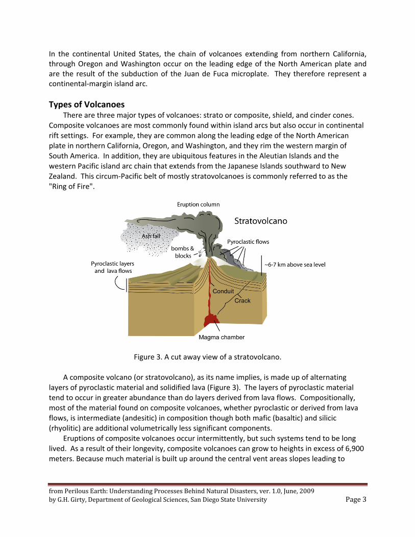
Types of Volcanoes There are three major types of volcanoes: strato or composite, shield, and cinder cones.
Composite volcanoes are most commonly found within island arcs but also occur in continental rift settings. For example, they are common along the leading edge of the North American plate in northern California, Oregon, and Washington, and they rim the western margin of South America. In addition, they are ubiquitous features in the Aleutian Islands and the western Pacific island arc chain that extends from the Japanese Islands southward to New Zealand. This circum‐Pacific belt of mostly stratovolcanoes is commonly referred to as the "Ring of Fire".
Figure 3. A cut away view of a stratovolcano.
A composite volcano (or stratovolcano), as its name implies, is made up of alternating layers of pyroclastic material and solidified lava (Figure 3). The layers of pyroclastic material tend to occur in greater abundance than do layers derived from lava flows. Compositionally, most of the material found on composite volcanoes, whether pyroclastic or derived from lava flows, is intermediate (andesitic) in composition though both mafic (basaltic) and silicic (rhyolitic) are additional volumetrically less significant components.
Eruptions of composite volcanoes occur intermittently, but such systems tend to be long lived. As a result of their longevity, composite volcanoes can grow to heights in excess of 6,900 meters. Because much material is built up around the central vent areas slopes leading to
from Perilous Earth: Understanding Processes Behind Natural Disasters, ver. 1.0, June, 2009 by G.H. Girty, Department of Geological Sciences, San Diego State University Page 4
summit areas of composite volcanoes tend to be much steeper than in shield volcanoes, but less steep than in cinder cones.
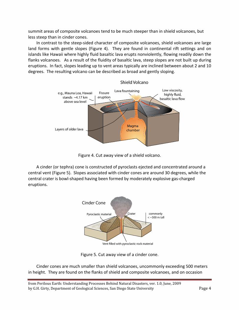
In contrast to the steep‐sided character of composite volcanoes, shield volcanoes are large land forms with gentle slopes (Figure 4). They are found in continental rift settings and on islands like Hawaii where highly fluid basaltic lava erupts nonviolently, flowing readily down the flanks volcanoes. As a result of the fluidity of basaltic lava, steep slopes are not built up during eruptions. In fact, slopes leading up to vent areas typically are inclined between about 2 and 10 degrees. The resulting volcano can be described as broad and gently sloping.
Figure 4. Cut away view of a shield volcano.
A cinder (or tephra) cone is constructed of pyroclasts ejected and concentrated around a central vent (Figure 5). Slopes associated with cinder cones are around 30 degrees, while the central crater is bowl‐shaped having been formed by moderately explosive gas‐charged eruptions.
Figure 5. Cut away view of a cinder cone.
Cinder cones are much smaller than shield volcanoes, uncommonly exceeding 500 meters in height. They are found on the flanks of shield and composite volcanoes, and on occasion
from Perilous Earth: Understanding Processes Behind Natural Disasters, ver. 1.0, June, 2009 by G.H. Girty, Department of Geological Sciences, San Diego State University Page 5
within calderas. They are associated with mafic, intermediate, and silicic volcanic systems. In the latter case, the tephra cone is referred to as a pumice cone.
So where does the magma that is erupted through these various volcanic edifices come from?
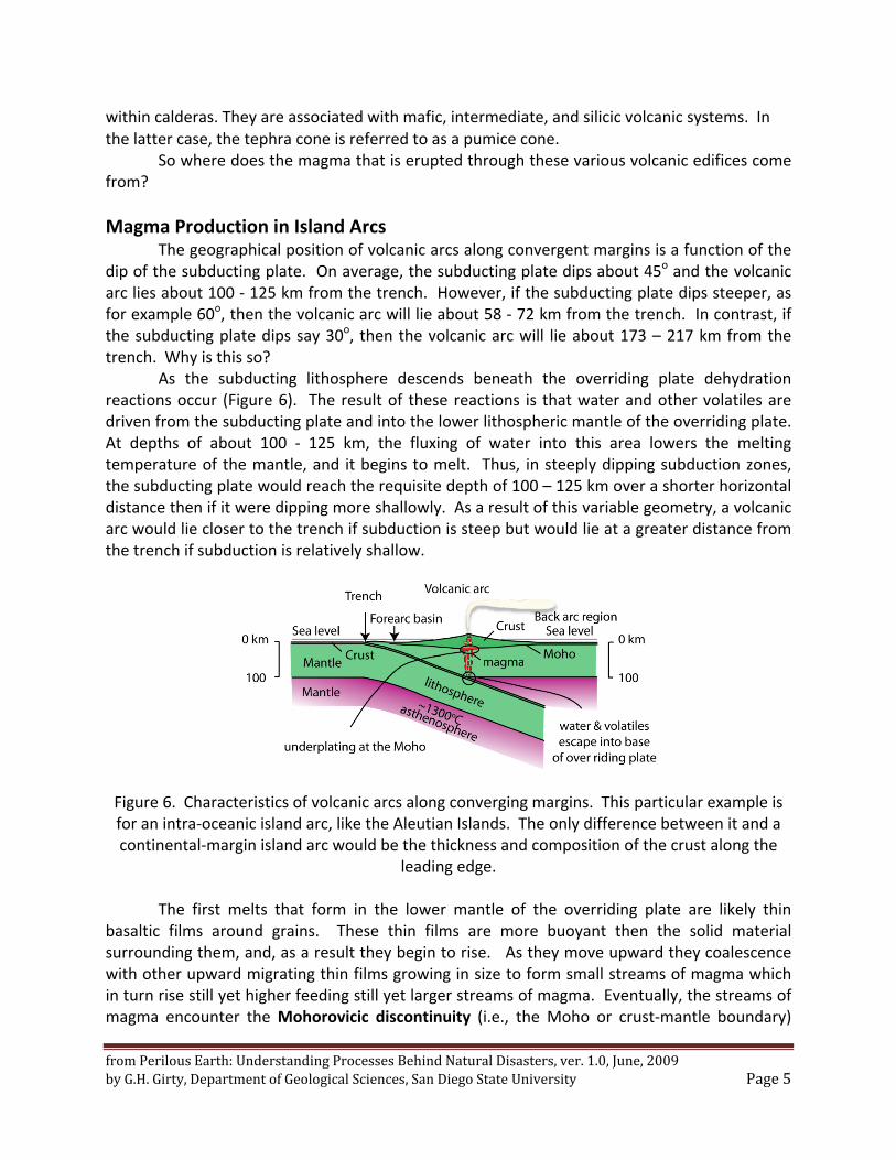
Magma Production in Island Arcs The geographical position of volcanic arcs along convergent margins is a function of the
dip of the subducting plate. On average, the subducting plate dips about 45o and the volcanic arc lies about 100 ‐ 125 km from the trench. However, if the subducting plate dips steeper, as for example 60o, then the volcanic arc will lie about 58 ‐ 72 km from the trench. In contrast, if the subducting plate dips say 30o, then the volcanic arc will lie about 173 – 217 km from the trench. Why is this so?
As the subducting lithosphere descends beneath the overriding plate dehydration reactions occur (Figure 6). The result of these reactions is that water and other volatiles are driven from the subducting plate and into the lower lithospheric mantle of the overriding plate. At depths of about 100 ‐ 125 km, the fluxing of water into this area lowers the melting temperature of the mantle, and it begins to melt. Thus, in steeply dipping subduction zones, the subducting plate would reach the requisite depth of 100 – 125 km over a shorter horizontal distance then if it were dipping more shallowly. As a result of this variable geometry, a volcanic arc would lie closer to the trench if subduction is steep but would lie at a greater distance from the trench if subduction is relatively shallow.
Figure 6. Characteristics of volcanic arcs along converging margins. This particular example is for an intra‐oceanic island arc, like the Aleutian Islands. The only difference between it and a continental‐margin island arc would be the thickness and composition of the crust along the
leading edge.
The first melts that form in the lower mantle of the overriding plate are likely thin basaltic films around grains. These thin films are more buoyant then the solid material surrounding them, and, as a result they begin to rise. As they move upward they coalescence with other upward migrating thin films growing in size to form small streams of magma which in turn rise still yet higher feeding still yet larger streams of magma. Eventually, the streams of magma encounter the Mohorovicic discontinuity (i.e., the Moho or crust‐mantle boundary)
from Perilous Earth: Understanding Processes Behind Natural Disasters, ver. 1.0, June, 2009 by G.H. Girty, Department of Geological Sciences, San Diego State University Page 6
where their upward migration is arrested. Geologists describe the accumulation of magma at the crust‐mantle boundary as ponding or underplating (Figure 6).
While ponded at the Moho magma may mix with other batches or streams of magma, or assimilate portions of the adjacent crust. In addition, during storage at the Moho the composition of the magma can be modified by crystal fractionation while convective overturn of the slowly cooling magma can homogenize the melt. Eventually, some magma will break free from the Moho and rise higher into the crust ponding to form magma chambers (Figure 6). Dikes, i.e., magma flowing through transient tabular fractures, then may feed magma from lower to higher crustal level chambers. In many cases, this complicated plumbing system eventually feeds a magma chamber lying beneath a volcano. It is in this near‐surface sub‐volcanic magma chamber that key changes in the physical attributes of the magma take place that control how it will be expelled from the volcano. Prior to considering how these changes occur, let’s take a brief look at intraplate hotspots and continental rift settings, two additional areas where voluminous quantities of magma are produced.
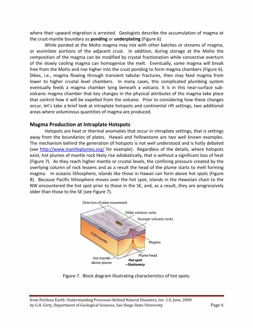
Magma Production at Intraplate Hotspots Hotspots are heat or thermal anomalies that occur in intraplate settings, that is settings away from the boundaries of plates. Hawaii and Yellowstone are two well known examples. The mechanism behind the generation of hotspots is not well understood and is hotly debated (see http://www.mantleplumes.org/ for example). Regardless of the details, where hotspots exist, hot plumes of mantle rock likely rise adiabatically, that is without a significant loss of heat (Figure 7). As they reach higher mantle or crustal levels, the confining pressure created by the overlying column of rock lessens and as a result the head of the plume starts to melt forming magma. In oceanic lithosphere, islands like those in Hawaii can form above hot spots (Figure 8). Because Pacific lithosphere moves over the hot spot, islands in the Hawaiian chain to the NW encountered the hot spot prior to those in the SE, and, as a result, they are progressively older than those to the SE (see Figure 7).
Figure 7. Block diagram illustrating characteristics of hot spots.
from Perilous Earth: Understanding Processes Behind Natural Disasters, ver. 1.0, June, 2009 by G.H. Girty, Department of Geological Sciences, San Diego State University Page 7
Figure 8. In this Earth Explorer 5.0 DEM image of the central Pacific, Hawaii may lie over a mantle plume lying beneath the NW moving Pacific plate.
In hot spot settings like that in Hawaii, voluminous quantities of highly fluid lava are
erupted and form large shield volcanoes like Mauna Loa. In contrast, when hotspots form within continental lithosphere, as for example at Yellowstone, then violent pyroclastic eruptions of very viscous magma can occur. Such eruptions may alternate with extrusion of lava flows and build large stratovolcanoes.
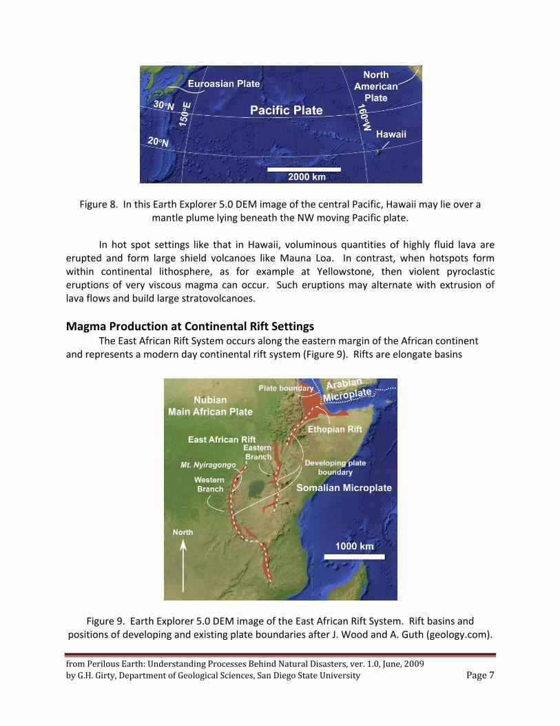
Magma Production at Continental Rift Settings The East African Rift System occurs along the eastern margin of the African continent
and represents a modern day continental rift system (Figure 9). Rifts are elongate basins
Figure 9. Earth Explorer 5.0 DEM image of the East African Rift System. Rift basins and positions of developing and existing plate boundaries after J. Wood and A. Guth (geology.com).
from Perilous Earth: Understanding Processes Behind Natural Disasters, ver. 1.0, June, 2009 by G.H. Girty, Department of Geological Sciences, San Diego State University Page 8
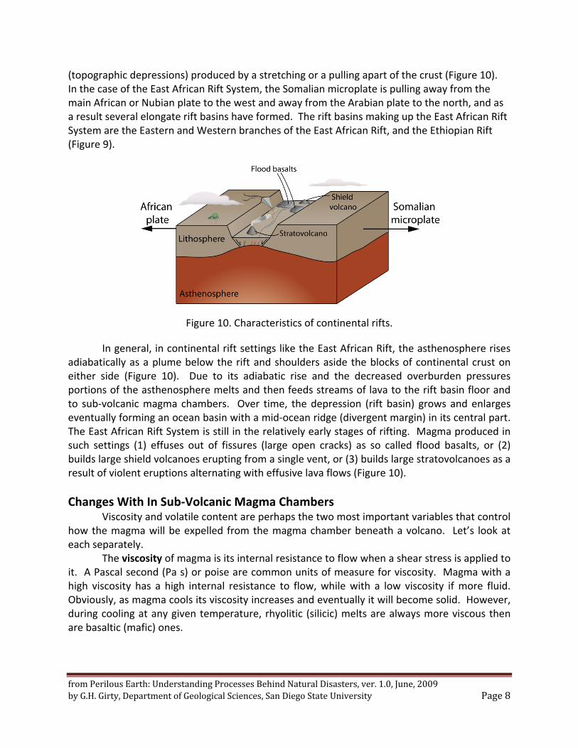
(topographic depressions) produced by a stretching or a pulling apart of the crust (Figure 10). In the case of the East African Rift System, the Somalian microplate is pulling away from the main African or Nubian plate to the west and away from the Arabian plate to the north, and as a result several elongate rift basins have formed. The rift basins making up the East African Rift System are the Eastern and Western branches of the East African Rift, and the Ethiopian Rift (Figure 9).
Figure 10. Characteristics of continental rifts.
In general, in continental rift settings like the East African Rift, the asthenosphere rises adiabatically as a plume below the rift and shoulders aside the blocks of continental crust on either side (Figure 10). Due to its adiabatic rise and the decreased overburden pressures portions of the asthenosphere melts and then feeds streams of lava to the rift basin floor and to sub‐volcanic magma chambers. Over time, the depression (rift basin) grows and enlarges eventually forming an ocean basin with a mid‐ocean ridge (divergent margin) in its central part. The East African Rift System is still in the relatively early stages of rifting. Magma produced in such settings (1) effuses out of fissures (large open cracks) as so called flood basalts, or (2) builds large shield volcanoes erupting from a single vent, or (3) builds large stratovolcanoes as a result of violent eruptions alternating with effusive lava flows (Figure 10).
Changes With In Sub‐Volcanic Magma Chambers Viscosity and volatile content are perhaps the two most important variables that control
how the magma will be expelled from the magma chamber beneath a volcano. Let’s look at each separately.
The viscosity of magma is its internal resistance to flow when a shear stress is applied to it. A Pascal second (Pa s) or poise are common units of measure for viscosity. Magma with a high viscosity has a high internal resistance to flow, while with a low viscosity if more fluid. Obviously, as magma cools its viscosity increases and eventually it will become solid. However, during cooling at any given temperature, rhyolitic (silicic) melts are always more viscous then are basaltic (mafic) ones.
from Perilous Earth: Understanding Processes Behind Natural Disasters, ver. 1.0, June, 2009 by G.H. Girty, Department of Geological Sciences, San Diego State University Page 9
Dissolving water into magma decreases its viscosity, making it more fluid. However, the degree of this increasing fluidity is dependent upon composition. For example, dissolved water has a greater affect on the viscosity of rhyolitic silicic liquids then it does on basaltic mafic ones.
The solubility of any substance refers to its ability to be dissolved within a liquid. In magma, the solubility of the volatile phase (mostly H2O and CO2) is controlled, in large part, by confining pressure, i.e., the pressure exerted by the column of rock lying above the magma. Obviously, the greater the column of rock overlying the magma, the higher the confining pressure. In general, the solubility of volatiles in magma rising upward through the crust decreases as it moves toward shallow near‐surface depths. Eventually, at a certain critical relatively shallow depth, it will become supersaturated with H2O and CO2 and these phases will begin to exsolve (separate from) from the magma. When this happens H2O and CO2 will exist as a distinct and separate gas phase within the liquid magma.
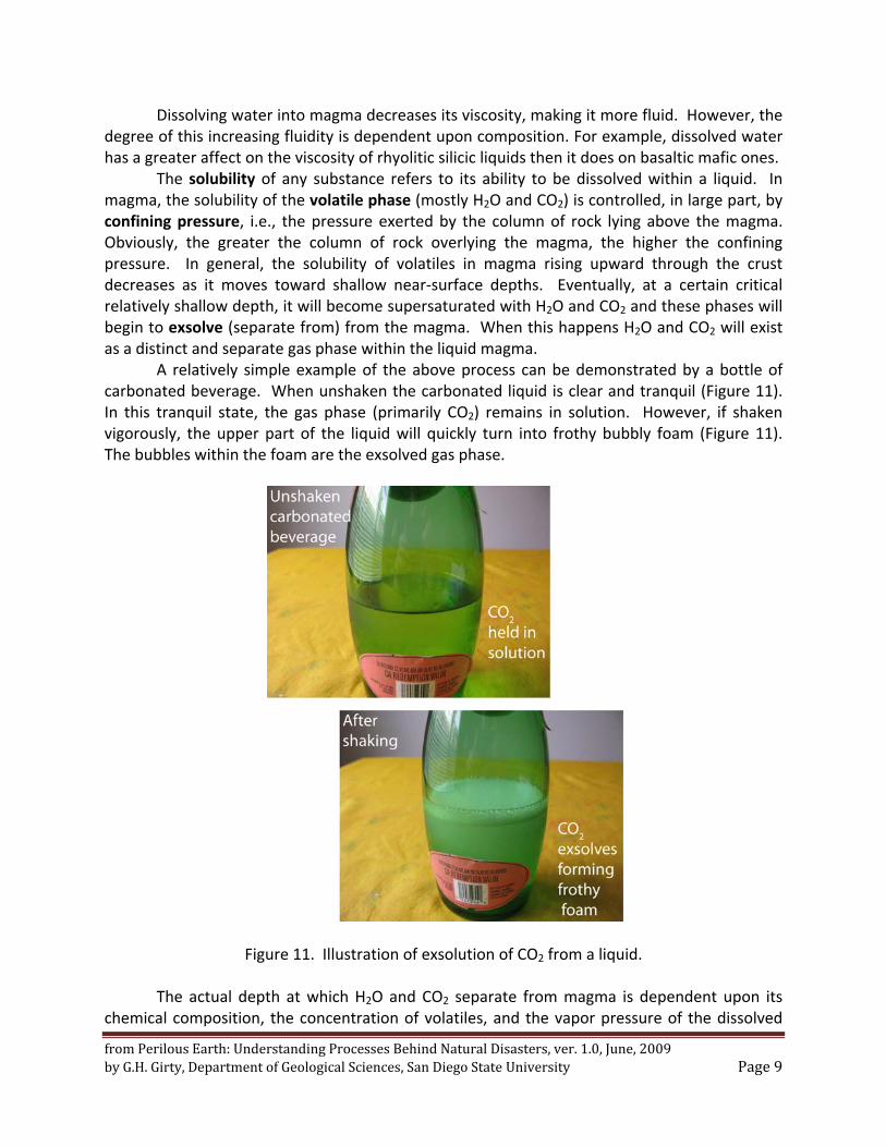
A relatively simple example of the above process can be demonstrated by a bottle of carbonated beverage. When unshaken the carbonated liquid is clear and tranquil (Figure 11). In this tranquil state, the gas phase (primarily CO2) remains in solution. However, if shaken vigorously, the upper part of the liquid will quickly turn into frothy bubbly foam (Figure 11). The bubbles within the foam are the exsolved gas phase.
Figure 11. Illustration of exsolution of CO2 from a liquid.
The actual depth at which H2O and CO2 separate from magma is dependent upon its chemical composition, the concentration of volatiles, and the vapor pressure of the dissolved
from Perilous Earth: Understanding Processes Behind Natural Disasters, ver. 1.0, June, 2009 by G.H. Girty, Department of Geological Sciences, San Diego State University Page 10
volatiles relative to the confining pressure. Vapor pressure is the pressure produced by H2O and CO2 gas separating from the magma at a given temperature under equilibrium conditions. Under such conditions, the rate at which H2O and CO2 separate from the magma is equal to the rate at which they dissolve back into it. Within a given magma, a larger volatile content will produce a larger vapor pressure than would magma with a lesser concentration of volatiles.
Exsolution of H2O and CO2 will occur when the vapor pressure equals the confining pressure. Hence, for a given magma exsolution will commence at a greater crustal depth if it has a larger concentration of volatiles then does a similar magma with a smaller volatile content.
If the exsolution of H2O and CO2 is a result of lowered confining pressure, then it is called first boiling or isothermal decompression. The immediate effect of exsolution of H2O and CO2 during first boiling is to increase the viscosity of the magma, i.e., its resistance to shear, thus, making it less fluid. Under this situation, if the vapor pressure of the exsolved gas phase continues to increase, then it has the potential to explosively disrupt the magma.
In contrast to first boiling which occurs without a change in temperature (isothermally), the effect of crystallizing anhydrous minerals like olivine, pyroxene, and the feldspars during a drop in temperature is to increase the concentration of the volatile phase in the liquid magma. This result in turn increases the vapor pressure within the magma, and if it rises to equal that of the confining pressure, then second or retrograde boiling occurs.
Vesiculation refers to the general process of exsolution of volatiles from magma. It can be produced by either of the above two processes. If magma is degassed without an explosive eruption occurring, then it will effuse from the volcano as lava. Otherwise it will erupt in varying degrees of explosivity depending upon its volatile content and composition.
An Explosive Volcanic Eruption
For an explosive volcanic eruption to occur, vesiculation must first take place. However, rhyolitic, rhyodacitic, and dacitic magmas are more viscous than are andesitic liquids. In turn, andesitic magma is more viscous than a basaltic silicate liquid. During vesiculation the viscosity of silicic to intermediate magmas (e.g., andesitic, dacitic to rhyolitic) prevents the gas phase from migrating through it, and hence the likely hood of an explosive volcanic eruption is greater than in a mafic (e.g., basaltic) magma where the exsolving gases can move more easily through the magma.
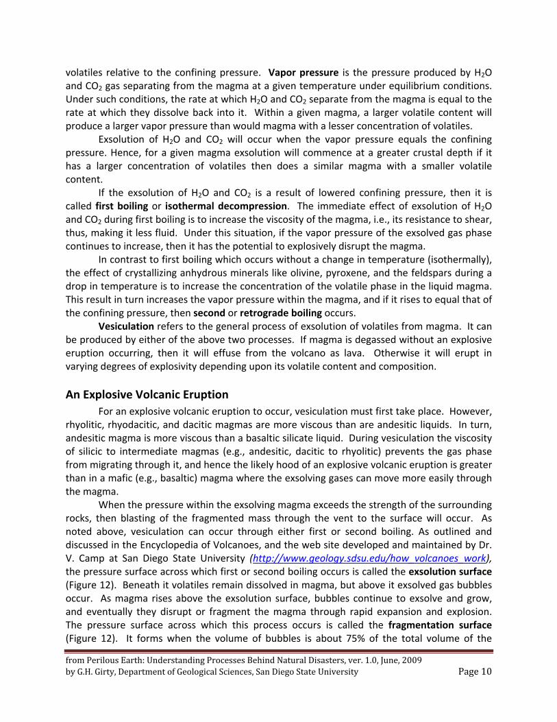
When the pressure within the exsolving magma exceeds the strength of the surrounding rocks, then blasting of the fragmented mass through the vent to the surface will occur. As noted above, vesiculation can occur through either first or second boiling. As outlined and discussed in the Encyclopedia of Volcanoes, and the web site developed and maintained by Dr. V. Camp at San Diego State University (http://www.geology.sdsu.edu/how_volcanoes_work), the pressure surface across which first or second boiling occurs is called the exsolution surface (Figure 12). Beneath it volatiles remain dissolved in magma, but above it exsolved gas bubbles occur. As magma rises above the exsolution surface, bubbles continue to exsolve and grow, and eventually they disrupt or fragment the magma through rapid expansion and explosion. The pressure surface across which this process occurs is called the fragmentation surface (Figure 12). It forms when the volume of bubbles is about 75% of the total volume of the
from Perilous Earth: Understanding Processes Behind Natural Disasters, ver. 1.0, June, 2009 by G.H. Girty, Department of Geological Sciences, San Diego State University Page 11
magma column. The fragmentation surface separates the exsolving magma below from the eruptive column above, and thus represents the point source of the material in the overlying eruption column.
The eruption column is the region of hot gas and fragmented pyroclastic materials lying above the fragmentation surface. It transfers materials from the fragmentation surface to the atmosphere, and can be subdivided into the gas thrust, convective thrust, and umbrella regions (Figure 12). The gas thrust region occurs in the lower part of the eruption column where it consists of pyroclastic material, some still plastic, and gases driven vertically upward through expansion. The convective thrust region comprises about 90% of the eruption column and occurs where, due to the fall out of pyroclastic particles, the density of the eruption column becomes less than that of the atmosphere, and hence the column is driven upward by
Figure 12. Characteristics of the eruption column derived from the eruption of volatile‐rich
andesitic or dacitic to rhyolitic magma. Adapted from Cioni et al. (2000) and http://www.geology.sdsu.edu/how_volcanoes_work/.
convective up rise. The umbrella region or downwind plume occurs at the top of the eruption column. It develops when the density of the eruption column is equal to the surrounding atmosphere.
During and following an eruption pyroclastic material can be pulled gravitational from the umbrella region. Such material characteristically rains down on the land surface blanketing it as an air‐fall deposit (Figure 13). Hence, a rock derived from an air‐fall deposit composed mostly of ash would be an air‐fall tuff while one composed of lapilli would be an air‐fall lapillistone.
from Perilous Earth: Understanding Processes Behind Natural Disasters, ver. 1.0, June, 2009 by G.H. Girty, Department of Geological Sciences, San Diego State University Page 12
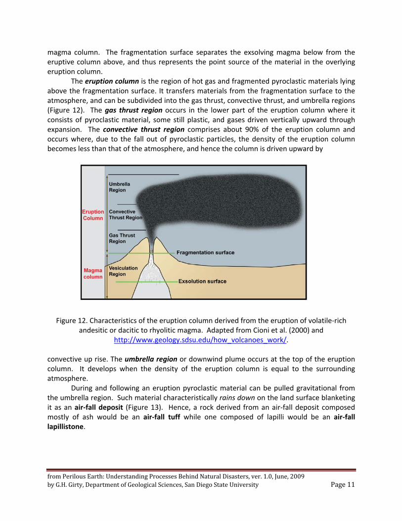
Figure 13. Ash fall from the Mount St. Helens eruption, Yakima, Washington, May 1980. Photograph from United States Geological Survey. If vehicular traffic was not disturbing the ash
fall, then it would form a layer of loose unconsolidated ash. Pyroclastic flows, sometimes called nuees ardentes (French for "glowing clouds"), are
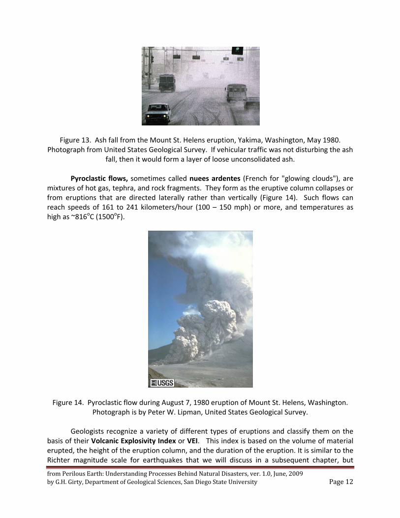
mixtures of hot gas, tephra, and rock fragments. They form as the eruptive column collapses or from eruptions that are directed laterally rather than vertically (Figure 14). Such flows can reach speeds of 161 to 241 kilometers/hour (100 – 150 mph) or more, and temperatures as high as ~816oC (1500oF).
Figure 14. Pyroclastic flow during August 7, 1980 eruption of Mount St. Helens, Washington.
Photograph is by Peter W. Lipman, United States Geological Survey.
Geologists recognize a variety of different types of eruptions and classify them on the basis of their Volcanic Explosivity Index or VEI. This index is based on the volume of material erupted, the height of the eruption column, and the duration of the eruption. It is similar to the Richter magnitude scale for earthquakes that we will discuss in a subsequent chapter, but
from Perilous Earth: Understanding Processes Behind Natural Disasters, ver. 1.0, June, 2009 by G.H. Girty, Department of Geological Sciences, San Diego State University Page 13
ranges from 0 to 8 rather than from 1 to 10. On the VEI, each interval represents an increase of a factor of ten. In other words the scale is logarithmic. On such a scale, an eruption of VEI 4 is 10 times larger than a 3 and one hundred times larger than a 2. Here I will briefly consider five distinctive types of eruptions and where they fall on the VEI. The five styles of eruption are hawaiian, strombolian, vulcanian, plinian, and ultraplinian. Eruptions of hawaiian and strombolian type typically produce so called shield volcanoes, while those of volcanian, plinian, and ultraplinian produce so called strato or composite volcanoes. The latter are also characteristic of island arcs while shield volcanoes are more often found in intraplate island settings. Hawaiian Eruptions
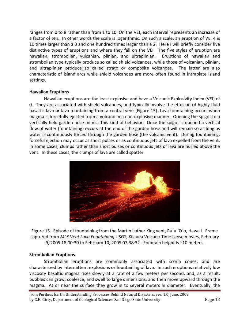
Hawaiian eruptions are the least explosive and have a Volcanic Explosivity Index (VEI) of 0. They are associated with shield volcanoes, and typically involve the effusion of highly fluid basaltic lava or lava fountaining from a central vent (Figure 15). Lava fountaining occurs when magma is forcefully ejected from a volcano in a non‐explosive manner. Opening the spigot to a vertically held garden hose mimics this kind of behavior. Once the spigot is opened a vertical flow of water (fountaining) occurs at the end of the garden hose and will remain so as long as water is continuously forced through the garden hose (the volcanic vent). During fountaining, forceful ejection may occur as short pulses or as continuous jets of lava expelled from the vent. In some cases, clumps rather than short pulses or continuous jets of lava are hurled above the vent. In these cases, the clumps of lava are called spatter.
Figure 15. Episode of fountaining from the Martin Luther King vent, Pu`u `O`o, Hawaii. Frame captured from MLK Vent Lava Fountaining USGS, Kilauea Volcano Time Lapse movies, February
9, 2005 18:00:30 to February 10, 2005 07:38:32. Fountain height is ~10 meters.
Strombolian Eruptions
Strombolian eruptions are commonly associated with scoria cones, and are characterized by intermittent explosions or fountaining of lava. In such eruptions relatively low viscosity basaltic magma rises slowly at a rate of a few meters per second, and, as a result, bubbles can grow, coalesce, and swell to large dimensions, and then move upward through the magma. At or near the surface they grow in to several meters in diameter. Eventually, the
from Perilous Earth: Understanding Processes Behind Natural Disasters, ver. 1.0, June, 2009 by G.H. Girty, Department of Geological Sciences, San Diego State University Page 14
bubbles burst and hurl globs of partially molten magma into the air along parabolic trajectories. The partially molten magma fragments are aerodynamically streamlined as they are shot through the atmosphere and accumulate as bombs around the vent area. Strombolian eruptions are sometimes called burps as they occur as short blasts separated by periods of less than a tenth of a second to several hours. Strombolian eruptions are characterized by a VEI of 1 or 2 and may or may not produce pyroclastic accumulations.
Volcanian Eruptions
Volcanian eruptions are commonly associated with stratovolcanoes and scoria cones. They commonly involve relatively viscous andesitic to dacitic magma. Because such magma is relatively viscous, exsolving gases can’t readily escape, and, as a result, significant pressures can arise resulting in explosive eruptions with eruption columns reaching 5 to 10 km in height. The exsolution surface during such eruptions commonly lies deep within the magma chamber.
In contrast to plinian and strombolian eruptions, discrete bursts taking place at intervals of minutes to hours are characteristic of the initial stages of volcanian eruptions. During such bursts bombs and blocks are hurled at high velocity from the volcanic vent. Often the blocks and bombs represent shattered fragments of lava that had plugged the vent prior to the eruption and viscous blobs of magma, respectively. They accumulate and are prominent near the vent, but the greatest volume of erupted material is finer grained ash. Minor pyroclastic flows may occur during volcanian eruptions.
Some volcanian eruptions are produced by ground‐water seeping into the vent and then vaporizing when coming into contact with magma, thus leading to a significant increase in pressure.
The VEI for vulcanian eruptions is typically between 2 and 4.
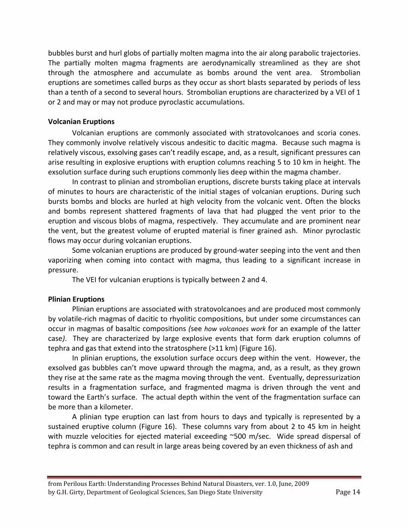
Plinian Eruptions Plinian eruptions are associated with stratovolcanoes and are produced most commonly
by volatile‐rich magmas of dacitic to rhyolitic compositions, but under some circumstances can occur in magmas of basaltic compositions (see how volcanoes work for an example of the latter case). They are characterized by large explosive events that form dark eruption columns of tephra and gas that extend into the stratosphere (>11 km) (Figure 16).
In plinian eruptions, the exsolution surface occurs deep within the vent. However, the exsolved gas bubbles can’t move upward through the magma, and, as a result, as they grown they rise at the same rate as the magma moving through the vent. Eventually, depressurization results in a fragmentation surface, and fragmented magma is driven through the vent and toward the Earth’s surface. The actual depth within the vent of the fragmentation surface can be more than a kilometer.
A plinian type eruption can last from hours to days and typically is represented by a sustained eruptive column (Figure 16). These columns vary from about 2 to 45 km in height with muzzle velocities for ejected material exceeding ~500 m/sec. Wide spread dispersal of tephra is common and can result in large areas being covered by an even thickness of ash and
from Perilous Earth: Understanding Processes Behind Natural Disasters, ver. 1.0, June, 2009 by G.H. Girty, Department of Geological Sciences, San Diego State University Page 15
Figure 16. Photograph by D. Swanson, USGS, May 18, 1980 of Mount St.Helens plinian dacitic eruption.
pumice. In addition, the eruptive column may collapse generating a pyroclastic flow that will travel down the flanks of the volcano at hurricane‐force speeds. The VEI for plinian eruptions varies from 3 to 6.
Plinian eruptions typically are dacitic to rhyolitic in concentration. However, if magma with these compositions contains low concentrations of dissolved gases, then it will effuse out of the volcano as lava flows with little or no production of pyroclastic material. Ultraplinian Eruptions
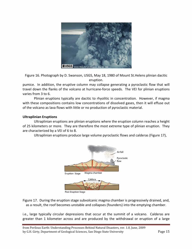
Ultraplinian eruptions are plinian eruptions where the eruption column reaches a height of 25 kilometers or more. They are therefore the most extreme type of plinian eruption. They are characterized by a VEI of 6 to 8.
Ultraplinian eruptions produce large volume pyroclastic flows and calderas (Figure 17),
Figure 17. During the eruption stage subvolcanic magma chamber is progressively drained, and, as a result, the roof becomes unstable and collapses (founders) into the emptying chamber.
i.e., large typically circular depressions that occur at the summit of a volcano. Calderas are greater than 1 kilometer across and are produced by the withdrawal or eruption of a large
from Perilous Earth: Understanding Processes Behind Natural Disasters, ver. 1.0, June, 2009 by G.H. Girty, Department of Geological Sciences, San Diego State University Page 16
volume of material from the subvolcanic magma chamber (Figure 17). They commonly are subsequently filled with lake water.
An excellent example of an ultraplinian eruption occurred about 2.0 million years ago at Yellowstone. The eruption produced a caldera that is about 60 miles (100 kilometers) in dimension and threw about 1000 cubic kilometers of debris into the atmosphere.
References Used in the Development of this Chapter Books and Papers Cas, R.A.F., and Wright, J.V., 1988, Volcanic successions: modern and ancient, Unwin Hymann
Inc., Winchester, Mass, 528 p. Cioni, R., Marianelli, P., Santacroce, R., and Sbrana, A., 2000, Plinian and subplinian eruptions, in
Sigurdsson, H., Houghton B., McNutt, S.R., Rymer, H., and Stix, J., eds., Encyclopedia of Volcanoes, Academic Press, New York, p. 477‐494.
Fisher, R.V., 1966, Rocks Composed of Volcanic Fragments, Earth‐Science Reviews, v. 1, p. 287‐
298. Frances, P., 1993, Volcanoes, A Planetary Perspective, Oxford University Press Inc., New York,
443 p. Schmid, R., 1981. Descriptive nomenclature and classification of pyroclastic deposits and
fragments: Recommendations of the International Union of Geological Sciences Subcommission on the Systematics of Igneous Rocks. Geology, v. 9, p. 41‐43.
Web Sites http://en.wikipedia.org/wiki/1980_eruption_of_Mount_St._Helens#Pyroclastic_flows http://hvo.wr.usgs.gov/gallery/kilauea/volcanomovies/ http://geology.com/articles/east‐africa‐rift.shtml http://pubs.usgs.gov/fs/fs027‐00/ http://volcano.oregonstate.edu/education http://volcanoes.usgs.gov/images/pglossary http://www.geology.sdsu.edu/how_volcanoes_work