Embed Size (px)
Citation preview

GEORGE WASHINGTON NATIONAL FOREST CHAPTER 2 - VISION
REVISED LAND AND RESOURCE MANAGEMENT PLAN 2 - 1
CHAPTER 2 – VISION DESIRED CONDITIONS OVERVIEW The USDA Forest Service Strategic Plan (FY 2007-2012) defines the mission of the Forest Service “to sustain the health, diversity, and productivity of the Nation’s forest and grasslands to meet the needs of present and future generations.” Desired conditions describe the vision for achieving the Forest Service’s mission on the George Washington National Forest. They portray the ecological, social and economic conditions the Forest is expected to provide in the future when the management direction in the Forest Plan has been successfully implemented. Desired conditions “paint a picture” of an area by describing the appearance and condition of various natural and social resources within the area, in part giving a sense of the type and extent of human influence that a forest visitor could expect. They were developed through an integration of input from the public comments we have received, national and regional Forest Service goals, changes and trends affecting the George Washington National Forest, and sound science for various resources and uses of the forest. Just like ecosystems, many desired conditions are interrelated across resource areas and are not mutually exclusive. A recurring theme that runs throughout the desired conditions for the George Washington NF is the focus on sustaining the diverse terrestrial, aquatic and vegetative communities unique to the central and southern Appalachians through the foundation of healthy watersheds, productive soils, and healthy airsheds. This in turn will allow the Forest to continue to provide a large holding of public land that can offer many different social and economic contributions for current and future generations. In some cases, our desired condition matches the current condition, so our goal is to maintain what we have. In other cases, we need to work toward meeting the desired conditions and success in achieving them can only be measured over the long-term. The Forest may need to make adjustments in the desired conditions if monitoring results indicate they are not achievable in the long-term or if there is an imbalance in what the Forest is accomplishing. Budget levels are an important factor in moving toward the desired conditions. Desired conditions are aspirations; they are not final decisions or commitments to action. This chapter identifies desired conditions that apply across the entire GWNF. Desired conditions that apply to certain management prescription areas (land allocations) are identified in Chapter 4. FORESTWIDE DESIRED CONDITIONS WATERSHEDS - WATER, SOIL, AIR, AND GEOLOGY WATERSHED RESOURCES Background The lands known today as the George Washington National Forest could hardly have been called a “forest” when it was officially designated in 1918. Clearing of steep mountain land for farming and grazing, iron ore mining, widespread and indiscriminate logging, and uncontrolled and intense wildfires in leftover logging debris, had led to severe erosion and increased flooding. As a result, by the early 1900s, much of the higher elevation mountains and ridges in southwestern Virginia had been transformed into stumps and brushfields (The Lands Nobody Wanted, Conservation Foundation Report, 1977). In 1911, Congress authorized and directed the Secretary of Agriculture “to examine, locate, and purchase such forested, cut-over, or denuded lands within the watersheds of navigable streams as in his judgment may be necessary to the regulation of the flow of navigable streams or for the production of timber.” In 1918, as a result of this Act, the George

CHAPTER 2 – VISION GEORGE WASHINGTON NATIONAL FOREST
2 - 2 REVISED LAND AND RESOURCE MANAGEMENT PLAN
Washington National Forest (known at that time as the Shenandoah National Forest) was established from these “lands nobody wanted.” The Forest Plan continues the tradition of watershed restoration, protection and stewardship begun on this national forest over 90 years ago. Maintenance and restoration of healthy, diverse, and resilient watersheds is a high priority in our management activities. Standards to protect water quality do not vary across the Forest. The George Washington National Forest is located in two major river drainages, the James and Potomac, both of which drain into the Chesapeake Bay. Priority watersheds highlight those watersheds with sensitive aquatic species, currently identified water quality concerns due to private land or natural causes (impaired streams), and public water supplies. These watersheds (listed in Appendix D) will be a priority for inventorying soil and water improvement needs, restoring streams and streamside systems to fully functioning systems, restoring habitat for sensitive aquatic and riparian species, addressing opportunities to reduce impacts from roads through relocation or decommissioning, and evaluating any new proposals for special uses that could affect water quality. Relatively undisturbed watersheds, or reference watersheds, help define systems with a high level of integrity. Five watersheds (Table 2-1) have been identified as reference watersheds on the Forest. The streams within these watersheds have existing water quality conditions considered to be representative of the ecological sub-section under relatively undisturbed, natural situations.
Table 2-1. Reference Watersheds
Reference Watershed Location Acres
Lost Run Laurel Fork Special Biological Area 592
Morgan Run Southern Massanutten 817
Ramseys Draft Ramseys Draft Wilderness 6,298
North Fork Simpson Creek Rich Hole Wilderness 1,900
Little Cove Creek Mt. Pleasant National Scenic Area and Appalachian Trail Corridor 867
Desired Conditions for Watersheds DC WTR-01: Watersheds within the Forest are resilient, have intact hydrologic function, and support the quality and quantity of water necessary for channel maintenance, aquatic habitats, riparian habitats and beneficial water uses, including public water supplies. Watersheds are not contributing sediment to streams at levels which adversely impact downstream uses, riparian ecosystems and aquatic lifecycles. Beavers provide a variety of beneficial watershed functions where their presence does not conflict with other desired conditions. DC WTR-02: The identified reference watersheds remain in a relatively undisturbed condition, with a low level of human intervention or impact. These areas retain a natural, forested appearance shaped primarily by natural processes. Uneven-aged forest communities with intermediate to high shade tolerance dominate the area. Landscapes feature a structurally diverse older aged forest community with a continuous forested canopy, with the exception of gaps created by storms, insects, diseases, and/or fire. Insects and diseases play a role in shaping future species composition and successional stages across these areas. Streams within reference watersheds have water quality conditions considered to be representative of the ecological sub-section under relatively undisturbed, natural situations.
GEORGE WASHINGTON NATIONAL FOREST CHAPTER 2 - VISION
REVISED LAND AND RESOURCE MANAGEMENT PLAN 2 - 3
DC WTR-03: Channeled ephemeral streams maintain their hydrologic function and the areas adjacent to these streams retain their ability to filter sediment from upslope disturbances while achieving the goals of the adjacent area. NOTE: Desired Conditions related to riparian areas are stated under Management Prescription Area 11–Riparian Corridors in Chapter 4.
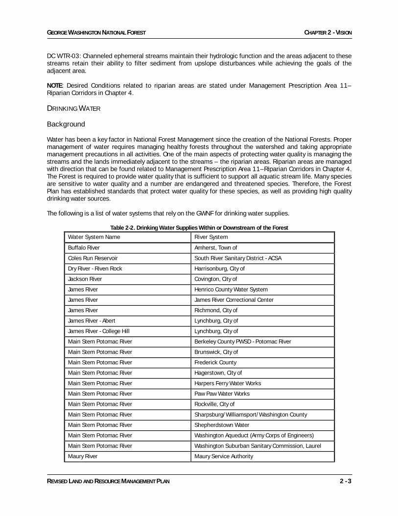
DRINKING WATER Background Water has been a key factor in National Forest Management since the creation of the National Forests. Proper management of water requires managing healthy forests throughout the watershed and taking appropriate management precautions in all activities. One of the main aspects of protecting water quality is managing the streams and the lands immediately adjacent to the streams – the riparian areas. Riparian areas are managed with direction that can be found related to Management Prescription Area 11–Riparian Corridors in Chapter 4. The Forest is required to provide water quality that is sufficient to support all aquatic stream life. Many species are sensitive to water quality and a number are endangered and threatened species. Therefore, the Forest Plan has established standards that protect water quality for these species, as well as providing high quality drinking water sources. The following is a list of water systems that rely on the GWNF for drinking water supplies.
Table 2-2. Drinking Water Supplies Within or Downstream of the Forest Water System Name River System
Buffalo River Amherst, Town of
Coles Run Reservoir South River Sanitary District - ACSA
Dry River - Riven Rock Harrisonburg, City of
Jackson River Covington, City of
James River Henrico County Water System
James River James River Correctional Center
James River Richmond, City of
James River - Abert Lynchburg, City of
James River - College Hill Lynchburg, City of
Main Stem Potomac River Berkeley County PWSD - Potomac River
Main Stem Potomac River Brunswick, City of
Main Stem Potomac River Frederick County
Main Stem Potomac River Hagerstown, City of
Main Stem Potomac River Harpers Ferry Water Works
Main Stem Potomac River Paw Paw Water Works
Main Stem Potomac River Rockville, City of
Main Stem Potomac River Sharpsburg/Williamsport/Washington County
Main Stem Potomac River Shepherdstown Water
Main Stem Potomac River Washington Aqueduct (Army Corps of Engineers)
Main Stem Potomac River Washington Suburban Sanitary Commission, Laurel
Maury River Maury Service Authority

CHAPTER 2 – VISION GEORGE WASHINGTON NATIONAL FOREST
2 - 4 REVISED LAND AND RESOURCE MANAGEMENT PLAN
Water System Name River System
North Fork Shenandoah River Broadway, Town of
North Fork Shenandoah River Food Processors Water Cooperative, Inc
North Fork Shenandoah River Strasburg, Town of
North Fork Shenandoah River Winchester, City of
North Fork Shenandoah River Woodstock, Town of
North River Bridgewater, Town of
North River Harrisonburg, City of
North River Dam Staunton, City of
Pedlar Reservoir Lynchburg, City of
Potomac River Fairfax County Water Authority
Potomac River Leesburg, Town of
Shenandoah River Berryville, Town of
Shenandoah River Charles Town Water Dept
Smith Creek Clifton Forge, Town of
South Branch Potomac River Romney Water Dept
South Branch Potomac River and South Fork of the South Branch Potomac River Moorefield Municipal Water
South Fork of the South Branch Potomac River Navy Information Operations Command/MB
South Fork Shenandoah River Front Royal, Town of
While most of these water sources are from rivers whose watersheds contain areas of private and federal lands, several reservoirs are located on rivers whose watersheds are predominantly National Forest System lands. These are:
· Coles Run Reservoir · Switzer Lake (located seven miles upstream from Harrisonburg’s intake) · Clifton Forge Reservoir · Staunton Reservoir · Lynchburg Reservoir
The following public water supplies on the GWNF are designated by the Commonwealth of Virginia-Department of Environmental Quality as Public Water Supplies:
Public Water Supply Description
Coles Run Coles Run and Mills Creek from South River Sanitary Districts raw water intake to its headwaters
Dry River and Skidmore Fork Dry River from Harrisonburg’s raw water intake (11.7 miles above its confluence with North River) to a point 5 miles upstream, unless otherwise designated
Jackson River Jackson River and its tributaries from Covington’s raw water intake to points 5 miles upstream
NF Shenandoah-Cedar Creek North Fork Shenandoah R and its tributaries from the Winchester raw water intake to points 5 miles upstream (to include Cedar Creek and its tributaries to their headwaters)

GEORGE WASHINGTON NATIONAL FOREST CHAPTER 2 - VISION
REVISED LAND AND RESOURCE MANAGEMENT PLAN 2 - 5
Public Water Supply Description
North Fork Shenandoah North Fork Shenandoah River and its tributaries from Strasburg’s raw water intake to points 5 miles upstream
North Fork Shenandoah North Fork Shenandoah River and its tributaries from Woodstock’s intake (1/4 mile upstream of Rt 609 bridge near Woodstock) to points 5 miles upstream
North River North River from Staunton Dam to its headwaters
Pedlar River Pedlar River and its tributaries from Lynchburg’s raw water intake (near Lynchburg Reservoir) to points 5 miles upstream
Smith Creek Smith Creek and Clifton Forge Reservoir from Clifton Forge’s raw water intake to their headwaters
Desired Conditions for Drinking Water DC DRW-01: Abundant clean water is produced within the Forest in response to the increasing downstream public need for drinking water, as many communities in Virginia, West Virginia and the District of Columbia rely on the high quality water from the George Washington National Forest for their drinking water. DC DRW-02: Forest management activities are focused on protecting drinking water sources while achieving the other ecological, social and economic goals of the Forest Plan. Practices to prevent contamination of drinking water sources are applied and monitored. DC DRW-03: Significant potential sources of drinking water contamination are identified and the susceptibility of the water supply to contamination from these sources is determined. Existing roads, trails, developed and dispersed recreation sites, and areas of concentrated recreation use are examined and problems mitigated. Old mining, grazing, and agricultural areas are stabilized and rehabilitated where necessary. DC DRW-04: Dams to store municipal drinking water are frequently found immediately downstream from the Forest on State or private lands. Expansion of these reservoirs to provide additional drinking water needs may be necessary in the future. Water-based recreation and associated facilities may be developed and maintained when these reservoirs are on or adjacent to national forest land and such development is acceptable to the municipality. DC DRW-05: Vegetation management activities are designed to maintain and restore habitat for a variety of native species in conditions that are resistant to large-scale disturbances that could affect drinking water. These large-scale disturbances include wildfires, landslides, and insect and disease epidemics (including but not limited to hemlock woolly adelgid, gypsy moth, southern pine beetle, and oak decline). SOIL RESOURCES Background Soils on the Forest have mainly formed in two geographical provinces, the Blue Ridge and the Appalachian Valley and Ridge. The northern part of the Glenwood-Pedlar Ranger District is located in the Blue Ridge Province and contains soils developed from metamorphic and igneous rock such as quartzite, phyllite, and greenstone. Soils developed from these parent bedrocks are moderately deep (20 inches to 40 inches to bedrock) to deep (greater than 40 inches to bedrock). These soils have moderate-to-severe erosion potential and moderate-to-high productivity levels. The southern slopes of soils derived from quartzite bedrock are low in productivity. The other four ranger districts are located in the Appalachian Valley and Ridge Province and contain soils that developed from sedimentary rock such as shale and sandstone. A small portion of the Warm Springs District in

CHAPTER 2 – VISION GEORGE WASHINGTON NATIONAL FOREST
2 - 6 REVISED LAND AND RESOURCE MANAGEMENT PLAN
Highland County is located in the transitional zone of the Allegheny Plateau physiographic province. The Laurel Fork area is in this transition zone. Soils have developed from sedimentary rock are moderately deep to shallow, less than 20 inches to bedrock. These soils have a slight-to-moderate erosion potential due to the common occurrence of greater than 35 percent rock fragments. North and west slopes are moderately productive. Southeast and southwest slopes are moderate-to-low in productivity. Many lower slope positions in the Appalachian Valley and Ridge Province contain a fragipan (restrictive layer) two to three feet beneath the surface. The fragipan restricts the downward movement of water and the growth of roots and can cause a perched water table that produces very wet surface conditions during periods of high precipitation. Some of the geology and soils of the Forest have a low buffering capacity against the effects of acid deposition, which has been occurring on the Forest for decades. These low buffered areas have the greatest risk of becoming increasingly acidic, having greater amounts of aluminum in rooting zones and having stressed ecosystems due to losses of beneficial plant-available soil nutrients. Desired Conditions for Soils DC SOL-01: Forest soils have adequate physical, biological, and chemical properties to maintain or improve vegetative growth, hydrologic function, nutrient cycling and slope stability. Minimal erosion and sedimentation occur due to the successful use of best management practices and erosion control during forest management activities. DC SOL-02: Generally, soils dedicated to growing vegetation have a normal soil profile that is typical for undisturbed soils on similar landforms in the local area. This soil profile includes an organic layer of partly to highly decomposed organic litter and humus. This layer is underlain by a layer of mineral soil, which is uncompacted, darker in color, and higher in available plant nutrients than the soil layers below it. Soil compaction does not prevent vegetation from growing. Soils dedicated to growing vegetation, which have been altered by past disturbance, are recovering toward a pre-disturbance condition with vegetative cover. Areas dedicated for other uses, such as campgrounds and system roads and trails, are not contributing above normal amounts of sediment to stream channels. Soil productivity is sustained through nitrogen and carbon fixation, mineral release from weathering parent material, decaying organic matter, and translocation of nutrients. DC SOL-03: Forests and streams located in areas of nutrient poor bedrock and soils are not being negatively affected by our management decisions.
AIR RESOURCES Background There are no Class I airsheds on the George Washington National Forest; however, Class I areas near the Forest include the James River Face Wilderness in the Jefferson National Forest and the Shenandoah National Park. The Forest is located downwind of two major areas of coal-fired power generation, the Ohio River Valley and the Tennessee Valley Authority. It is located within a day’s drive of a large percentage of the United States’ population and numerous major cities, including Washington DC and Richmond, Virginia. The heavily traveled Interstate Highway 81 runs through the length of the Forest. Nitrogen oxide, sulfur dioxide and fine particulates are the main pollutants emitted from these sources that are affecting resources within the Forest. Air quality in western Virginia is currently meeting all National Ambient Air Quality Standards (NAAQS) established by the Environmental Protection Agency. On the GWNF, prescribed burning is the management activity most likely to contribute to air pollution, and current burning levels are not contributing to exceedence
GEORGE WASHINGTON NATIONAL FOREST CHAPTER 2 - VISION
REVISED LAND AND RESOURCE MANAGEMENT PLAN 2 - 7
of air quality standards. However, prescribed burning levels associated with returning the national forests to more historic fire conditions will require an increase in forestwide prescribed burn acreages from recent years. This increase was anticipated and the Forest worked with Virginia Department of Environmental Quality (VDEQ) and other state air agencies to incorporate these increases into the emissions inventory used by VDEQ for Regional Haze and Ozone State Implementation Plans. Air modeling analyses out to the year 2018 show that even with the anticipated increase in prescribed fire emissions on the Forest, the State should be able to attain the NAAQS and show reasonable progress in visibility improvement. Although the NAAQS are not exceeded, Forest resources are affected by air pollution, especially sulfur dioxide. Air pollution that originates outside the Forest boundary is transported onto the Forest and contributes to acid deposition and regional haze. In both cases sulfate particles from sulfur dioxide emissions are the primary pollutants of concern. Fine sulfate particles contribute to visibility impairment and stream water acidification. Forest soils can also be affected where high sulfur deposition and sensitive soils/geology coincide. Sulfur deposition has declined over the past 20 years, and this is expected to continue as new pollution control programs are implemented by State and Federal governments. But affected streams do not recover immediately because stored sulfur is slowly released from the soil into the water and acidification continues. Forests and streams located in areas of base-poor bedrock (sandstone and granite) and with elevations above 3,000 feet are being negatively affected by historic and current levels of acid deposition. This is especially true for spruce-fir forests. The two primary acidifying compounds are sulfates and nitrates. Of those two compounds, nitrate deposition is most important in spruce-fir forests. The sources of acidifying compounds are generally located off National Forest System lands, with coal-fired electric generation facilities and vehicles accounting for the bulk of sulfur and nitrogen emissions. When nitrogen is deposited in excess of forest nutrient needs, some nitrate will leave the soil and take with it essential nutrients. When nutrients are leached from soils, growth of vegetation can be reduced. Sulfur deposition can cause the same effects on soils when the capacity to absorb sulfur is exceeded. Sulfur and nitrogen compounds in the soil also cause acidification of high elevation streams, thereby endangering the habitat of native brook trout and other aquatic species. Recent and projected trends in air pollutants show sulfur compound emissions decreasing over the life of the Plan, whereas nitrogen compound emissions are projected to remain relatively flat. Ozone pollution is negatively affecting the health of sensitive forest tree species, black cherry for example. Ozone is formed through chemical reactions in the atmosphere between nitrogen oxide (from vehicles and coal-fired power generation) and volatile organic compounds (from industrial and natural sources) in the presence of sunlight. Ozone levels are highest during the summer. Recent studies suggest that competitiveness between tree species is changing over time due to elevated ozone levels. Tree species that are not sensitive to ozone will out-compete more sensitive species over time. Significant reductions in ozone pollution over the life of the Plan are not anticipated because nitrogen oxide emissions are not expected to decrease significantly. Desired Conditions for Air Quality DC AIR-01: Visitors to the Forest experience clean air and clear vistas, with recognition that the Forest is affected by human-caused regional haze originating predominantly from pollution sources outside the Forest boundaries. DC AIR-02: Activities on NFS lands meet the National Ambient Air Quality Standards designed to protect human health. Forest resources are free of air pollution impacts. DC AIR-03: Sulfur and nitrogen deposition decline to levels not harmful to forest resources. DC AIR-04: Smoke impacts on the general public and adjacent landowners from prescribed fires are minimal and short-term.

CHAPTER 2 – VISION GEORGE WASHINGTON NATIONAL FOREST
2 - 8 REVISED LAND AND RESOURCE MANAGEMENT PLAN
GEOLOGIC RESOURCES Background Geologic resources include: groundwater; caves, sinkholes, disappearing streams and other karst features; evidence of climate change, such as Ice Age features; fossils and paleontological resources; volcanic features; unusual landforms; waterfalls; and interesting rocks and minerals. Groundwater-dependent ecosystems are areas where communities of plants, animals, and other organisms depend on access to, or discharge of, groundwater. Geologic materials and geologic processes control or influence a host of ecological factors, such as slope aspect, slope steepness, the areal extent of landforms and associated vegetation, the distribution and composition of soil parent material, the structure and composition of vegetation, the physical character of wetlands, riparian area and stream substrates, the quantity and quality of stream water and groundwater, and some natural disturbance regimes. The diversity of surface geology (bedrock and surface materials; structures, landforms, and dynamic processes acting on the earth's surface) is the foundation for most of the Forest's diversity of ecosystems. Surface geologic processes are a part of the natural disturbance regime in the Forest. These processes include: the erosion, transport and deposition of sediment; mass wasting or landsliding; flooding; changes in stream channels; groundwater flow; and the formation of caves, sinkholes and other karst features. Geologic hazards are geologic processes that may threaten public safety and damage infrastructure such as roads and campgrounds. Geologic hazards include flooding, sinkholes, ground collapse, piping, abandoned mines, groundwater pollution, and a wide range of landslides such as rock falls, rockslides, debris slides, debris flows, slumps, and stream bank failures. Geologic hazards can affect people, infrastructure, and natural resources on and off the Forest. Desired Conditions for Geologic Resources DC GEO-01: Geologic resources are identified and managed for educational, interpretative, scientific, scenic, paleontological, ecological, recreational, public use, historic, and/or archaeological values. DC GEO-02: Groundwater is protected. Management activities, especially in karst areas, are not adversely affecting groundwater. Groundwater-dependent ecosystems (such as springs, bogs, fens, seeps, and cave streams) are protected and sustained. DC GEO-03: Geologic hazards and potential threats to public safety, campgrounds, roads, bridges, trails, dams and other facilities are identified and managed. Ground-disturbing management activities are not causing or contributing to geologic hazards. DC GEO-04: Karst areas are identified and recognized as a geologic-based ecosystem vulnerable to groundwater contamination due to interaction between the surface and subsurface. Caves, sinkholes and other karst features function to maintain groundwater quality and provide habitat for species that depend on these features. DC GEO-05: Management activities are appropriate to the diverse geologic processes, structures, and materials.
GEORGE WASHINGTON NATIONAL FOREST CHAPTER 2 - VISION
REVISED LAND AND RESOURCE MANAGEMENT PLAN 2 - 9
ECOLOGICAL SYSTEMS DIVERSITY Background Ecosystem diversity is defined as the variety and relative extent of ecological systems including their species composition, structure (the successional stages and canopy conditions of that system across a landscape) and associated processes. Ecological systems are recurring groups of biological and vegetative communities that are found in similar physical environments and are influenced by similar dynamic ecological processes, geological substrates, and/or environmental gradients. These systems have similar potential and opportunities for management. Vegetation, wildlife, soils, water, geology, climate, fire and other natural disturbances all contribute to ecosystem diversity. By restoring and maintaining the key characteristics, conditions, and functionality of the native ecosystems found on the GWNF to the extent possible, the Forest should be able to sustain ecosystem diversity and also provide for the needs of the diverse plant and animal species on the forest (species diversity). Ecological sustainability in turn supports social and economic sustainability. Ecological systems provide opportunities for nature watching, hunting, fishing, wildflower viewing, and other recreational activities, and support local communities through sustainable forest products. In the abiotic component of ecosystems, geological diversity is the foundation for terrestrial and aquatic ecosystems. The diversity of both bedrock and surficial geology (below ground and surface materials, including structures, landforms, and dynamic processes acting on the earth's surface), combined with moisture regimes, determine the distribution and variety of the individual ecological systems on the landscape (Anderson and Ferree 2010). The Ridge and Valley section is composed of long belts of parallel, strike ridges and valleys trending in a northeast-southwest direction. A strike ridge is a linear, asymmetric ridge formed by the differential erosion of inclined sedimentary bedrock layers. One flank of the strike ridge is a steep slope cutting across several bedrock layers (antidip or scarp slope). In contrast, the other side of the ridge is a less steep slope conforming to the slope of the underlying bedrock layer (dip-slope). Pine, pine-oak, and drier oak types are found on the south to west facing slopes with dry to mesic oak on the north to east facing slopes. This pattern repeats itself along most of the ridges of the Ridge and Valley. The ridges consist of sandstone, shale, and siltstone with the occasional bands of limestone. Red spruce and northern hardwoods are found at the highest elevations along mountain crests and cool, moist northern slopes. The valleys are composed of shale and carbonate bedrock (limestone and dolomite), creating distinctly different “poor valleys” (less fertile) and “rich valleys” (more fertile). Shale barrens are found in the driest, least fertile aspects while cove forests occur in the more fertile, moist concave landforms. It is in the carbonate valleys where karst terrain with numerous sinkholes and caves are often found, plus the occasional alkaline glade. The Ridge and Valley has a trellis drainage pattern. The strike ridge has two distinct drainage systems. The antidip slope has many, closely-spaced, steep, deeply-incised hollows; the dip-slope has fewer, widely-spaced, less steep and less incised drainages. The Blue Ridge section is the mountain range on the easternmost part of the Forest dominated by granitic bedrock with metamorphosed sedimentary rocks on the lower slopes of the western flank. Lenses of basalt volcanic rocks intrude into and add to diversity in the granitic terrain. In contrast to the linear bands of alternating bedrock layers in the Ridge and Valley, the massive granitic bedrock of the Blue Ridge forms a broad landscape of more homogeneous bedrock and random landforms. The occurrences and composition of ecological systems in the Blue Ridge are similar to the Ridge and Valley but the pattern tends to be more random. Red spruce is not found in this portion of the Blue Ridge, but mafic glades and woodlands occur here and not in the Ridge and Valley. The quantity and quality of surface water and groundwater has less variation in the widespread granitic landscapes, which have a radial and dendritic drainage pattern. Ecological Systems The framework for classifying terrestrial ecological systems on the GWNF was defined using NatureServe’s International Ecological Classification Standards (NatureServe 2004a, 2004b) and cross-walked with the Virginia Department of Conservation and Recreation–Division of Natural Heritage Vegetation Community types and Forest Service FSVeg forest types (see Ecosystem Diversity Report, FEIS Appendix E). Twenty-four terrestrial ecological systems were identified for the GWNF that represent both major and rare community
CHAPTER 2 – VISION GEORGE WASHINGTON NATIONAL FOREST
2 - 10 REVISED LAND AND RESOURCE MANAGEMENT PLAN
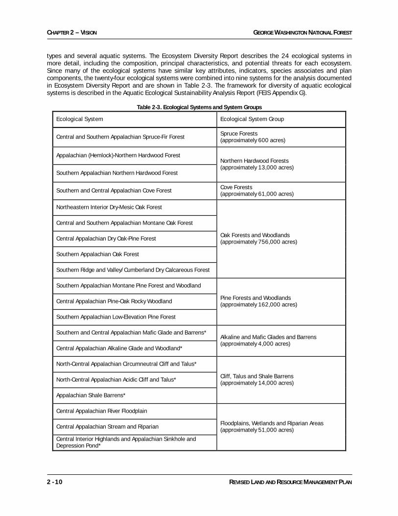
types and several aquatic systems. The Ecosystem Diversity Report describes the 24 ecological systems in more detail, including the composition, principal characteristics, and potential threats for each ecosystem. Since many of the ecological systems have similar key attributes, indicators, species associates and plan components, the twenty-four ecological systems were combined into nine systems for the analysis documented in Ecosystem Diversity Report and are shown in Table 2-3. The framework for diversity of aquatic ecological systems is described in the Aquatic Ecological Sustainability Analysis Report (FEIS Appendix G).
Table 2-3. Ecological Systems and System Groups
Ecological System Ecological System Group
Central and Southern Appalachian Spruce-Fir Forest Spruce Forests (approximately 600 acres)
Appalachian (Hemlock)-Northern Hardwood Forest Northern Hardwood Forests (approximately 13,000 acres)
Southern Appalachian Northern Hardwood Forest
Southern and Central Appalachian Cove Forest Cove Forests (approximately 61,000 acres)
Northeastern Interior Dry-Mesic Oak Forest
Oak Forests and Woodlands (approximately 756,000 acres)
Central and Southern Appalachian Montane Oak Forest
Central Appalachian Dry Oak-Pine Forest
Southern Appalachian Oak Forest
Southern Ridge and Valley/Cumberland Dry Calcareous Forest
Southern Appalachian Montane Pine Forest and Woodland
Pine Forests and Woodlands (approximately 162,000 acres) Central Appalachian Pine-Oak Rocky Woodland
Southern Appalachian Low-Elevation Pine Forest
Southern and Central Appalachian Mafic Glade and Barrens* Alkaline and Mafic Glades and Barrens (approximately 4,000 acres)
Central Appalachian Alkaline Glade and Woodland*
North-Central Appalachian Circumneutral Cliff and Talus*
Cliff, Talus and Shale Barrens (approximately 14,000 acres) North-Central Appalachian Acidic Cliff and Talus*
Appalachian Shale Barrens*
Central Appalachian River Floodplain
Floodplains, Wetlands and Riparian Areas (approximately 51,000 acres) Central Appalachian Stream and Riparian
Central Interior Highlands and Appalachian Sinkhole and Depression Pond*

GEORGE WASHINGTON NATIONAL FOREST CHAPTER 2 - VISION
REVISED LAND AND RESOURCE MANAGEMENT PLAN 2 - 11
Southern and Central Appalachian Bog and Fen*
North-Central Appalachian Acidic Swamp*
North-Central Appalachian Seepage Fen*
Caves and Karstlands Caves and Karstlands (approximately 119,000 acres)
* The systems with asterisks are considered rare or naturally small in scale
Spruce Forests Ecological System Group Found only in the higher elevations near border of Ridge & Valley and Alleghany Plateau (roughly the Virginia - West Virginia state line) this system is a predominately mature or old-growth forest with a diversity of vertical and age structure on sites to which this species is appropriate and of historical occurrence. Overstories are typically dominated by red spruce, but this system grades into northern hardwoods. Often other tree species found with red spruce include American beech, yellow birch, and sugar maple. The herbaceous layer is typically dominated by mosses, ferns, sedges, and forbs, The Spruce Forest system supports populations of rare species associated with boreal habitats to the north and endemic species associated with this habitat in the mid-Appalachians, such as the Virginia northern flying squirrel. Northern Hardwood Forests Ecological System Group Usually found in the highest elevations on the Forest this system is dominated by overstories that include American beech, sugar maple and yellow birch with some eastern hemlock. Midstories and understories are usually well developed. The understory varies quite a bit, in some places dominated by evergreen shrubs and in others by herbs. Cove Forests Ecological System Group This closed-canopy forest is found on concave landforms and is often associated with riparian areas. Overstories are typically dominated by yellow poplar, hemlock, birch, magnolia, basswood, and red maple. Midstories are well developed and fairly diverse. In acidic coves, rhododendron is often abundant. Understories have a well-developed herb layer, often very dense and usually high in species richness, in all but the acid coves. Well-developed and fairly diverse subcanopy and shrub layers are often also present in all but the acid coves. This system supports populations of associated rare species, such as ginseng. Oak Forests and Woodlands Ecological System Group This is the most common ecological system on the Forest and can be viewed as the primary forest in which all other vegetation types occur. Oak forests range from those found on moist (or mesic) sites to dry sites that then grade into yellow pine. Overstory trees on mesic sites are typically dominated by red oak, white oak and hickory with chestnut oak, black oak and scarlet oak on drier sites. Heath shrubs such as blueberry, huckleberry and mountain laurel are common in the understory, especially on drier sites and often form a dense shrub layer along with grasses and sedges. Fewer heath shrubs are found on mesic sites and the understory often consists of various perennial herbaceous plants. Pine Forests and Woodlands Ecological System Group Next to Oak Forest and Woodlands this ecological system is the most common on the Forest and occupies the upper slopes and south to west exposures. Overstories are typically dominated by table mountain pine, pitch pine, and some Virginia pine along with dry site oaks such as chestnut oak, scarlet oak, and bear oak. A dense heath shrub layer is almost always present. Mountain laurel is most typical and dominant, but species of blueberry and huckleberry along with fetterbush may also be dominant. Native grasses and sedges are common along with dry site herbs and forbs. Their density varies depending on shrub cover.

CHAPTER 2 – VISION GEORGE WASHINGTON NATIONAL FOREST
2 - 12 REVISED LAND AND RESOURCE MANAGEMENT PLAN
Cliffs, Talus, and Shale Barrens Ecological System Group Vegetation on and near shale barrens is mostly classified as woodland, but may include large open areas of sparse vegetation. Dominant trees are primarily chestnut oak, pitch pine, table mountain pine, and Virginia pine; although on higher-pH substrates the common trees include eastern red cedar and white ash. Shale barren endemic plants are diagnostic in the herb layer. The substrate includes areas of solid rock as well as unstable areas of shale scree, usually steeply sloped. The Cliff and Talus system comprises sparsely vegetated to partially wooded cliffs and talus slopes. It consists of vertical or near-vertical cliffs and the talus slopes below. In some cases, this system may take the form of upper-slope boulderfields without adjacent cliffs, where talus forms from freeze/thaw action cracking the bedrock. Most of the substrate is dry and exposed, but areas of seepage are often present. The vegetation is patchy and often sparse, punctuated with patches of small trees that may form woodlands in places. Alkaline Glades and Woodlands and Mafic Glades and Barrens Ecological System Group Alkaline Glades and Woodlands and Mafic Glades and Barrens support a patchy mosaic of open woodland and grassy herbaceous vegetation sometimes with a predominant woody short-shrub community present. The canopy species are species tolerant of dry, shallow soils, most commonly chestnut oak, pines and eastern red cedar. Shrubs may be dense, with species determined by soil chemistry and often include redbud and fragrant sumac. The herb layer is usually fairly dense and dominated by grasses, both in treeless areas and beneath open canopy. The forbs include species characteristic of other rock outcrops and grassland species, with a smaller number of forest species present. The Alkaline system consists of woodlands and open glades on thin soils over limestone, dolostone or similar calcareous rock. In some cases, the woodlands grade into closed-canopy forests. Eastern red cedar is often a common tree, and along with chinquapin oak is indicative of the limestone substrate. Warm season grasses such as big and little bluestem are often the dominant herbs; forb richness is often high. The mafic system found in the Blue Ridge consists of vegetation associated with shallow soils over predominantly mafic bedrock (which is rich in iron and magnesium), usually with significant areas of rock outcrops. Floodplains, Wetlands and Riparian Areas Ecological System Group Riparian Areas are functionally defined as areas with three-dimensional ecotones of interaction that include both terrestrial and aquatic ecosystems. They extend down into the groundwater, up above the canopy, outward across the floodplain, up the near-slopes that drain into the water, laterally into the terrestrial ecosystem, and along the watercourse at a variable width. The riparian corridor has distinctive suitable uses and standards so this ecological system is managed specifically through Management Prescription Area 11–Riparian Corridors. Overstories are typically dominated by the same trees occupying the oak and cove forest types. Midstories and understories are often well developed and diverse. This system supports populations of many associated rare species. Caves and Karstlands Ecological System Group This important ecological system is found to a limited degree on the Forest where it is associated with carbonate bedrock (limestone and dolostone) and often characterized by internal drainage. This bedrock type is typically found in valleys where it is dissolved by groundwater creating surface depressions (sinkholes) and underground caves and tunnels.
GEORGE WASHINGTON NATIONAL FOREST CHAPTER 2 - VISION
REVISED LAND AND RESOURCE MANAGEMENT PLAN 2 - 13
Structural Diversity Structural diversity involves both successional stage and canopy conditions that are important to all forested ecological systems. Structure is also important to non-forested systems. Every forested community requires a balance of structural classes representing a diversity of vertical structure that allows for recruitment of young growth to replace losses due to storm events, pest infestations, wildfires, and biological age. An appropriate balance of vertical structure within each community also provides habitat for associated terrestrial species that require either grass/forb-seedling/shrub (early seral), and/or trees (late seral) at some stage in their life cycle. These concepts are described in more detail in the Species Diversity section of this chapter. Early successional forest is defined as regenerating forest of 0 to 35 years of age, depending upon the ecological system. It is characterized by woody growth of regenerating trees and shrubs, often with a significant grass/forb component, and relatively low density or absent overstory. This condition is distinguished from permanent grass/shrubland habitats by having relatively dense woody vegetation, as opposed to grasses and forbs. Such conditions may be created by even-aged and two-aged regeneration cutting, and by natural disturbance events, such as windstorms, wildfire, and some insect or disease outbreaks. Ages defining the remaining successional stages vary by ecological system group. Mid-successional forest often begins to develop with the sapling/pole forest characterized by canopy closure of dense tree regeneration, with tree diameters typically smaller than 10 inches diameter at breast height. It then proceeds through stratification of over-, mid-, and understory layers. Late successional forests, from 50 to 100 years in age and older, include old growth conditions. This stage contains the largest trees and often has well-developed crown and canopy layers and scattered openings caused by tree mortality. Another important type of condition that combines elements of both early and mid – to late successional forest is open woodlands. Created and maintained largely by periodic fire disturbance regimes, open woodlands are characterized by an overstory of trees that are spaced far enough apart to allow sunlight to reach the forest floor. This structural condition allows the development of a grassy/shrubby/herbaceous/woody understory more typical of early successional forest and grassland/shrublands. Many species depend on the juxtaposition of both overstory mature and a well-developed grassy/shrubby/herbaceous understory for their life cycle needs. In this stage canopy openings range from individual or multiple tree gaps to widely spaced trees with open-grown crowns. Permanent grass/forb and seedling/sapling/shrub habitats are important elements of early successional habitat. Permanent openings typically are maintained for wildlife habitat on an annual or semi-annual basis with the use of cultivation, mowing, or other vegetation management treatments. These openings may contain native grasses and forbs or may be planted to non-native agricultural species such as clover, orchard grass, wheat, or small grains. Old fields are maintained on a less frequent basis (5-10 year intervals), usually with burning and mowing) or are succeeding to forest. They are largely influenced by past cultural activities and may be dense sod or a rapidly changing field of annual and perennial herbs, grasses, woody shrubs and tree seedlings.

CHAPTER 2 – VISION GEORGE WASHINGTON NATIONAL FOREST
2 - 14 REVISED LAND AND RESOURCE MANAGEMENT PLAN
Table 2-4. Definitions of Structural Classes
Open Land with less than 10 percent canopy cover in permanent or long-term open condition (grasslands, barrens, etc.; not timber harvest regeneration)
Early Successional or Regenerating Forest
Stands developing after a major disturbance or timber harvest, generally less than 11 years in age in the most common systems, but can be up to 35 years
Mid-Successional Open Canopy Forest
Stands beyond regeneration that stay in a relatively open canopy (canopy closure of 25-60%)
Mid-Successional Closed Canopy Forest
Stands beyond regeneration where the canopy closes (canopy closure of 61% or greater)
Late Successional Open Canopy Forest
Stands reaching older ages of mature trees (50-100 years or greater) and more lasting structural conditions with overall open canopy (canopy closure of 25-60%; typical of an area being thinned)
Late Successional Closed Canopy Forest
Stands reaching older ages of mature trees (50-100 years or greater) and more lasting structural conditions with a largely closed canopy (all layers) greater than 60%, includes natural canopy gaps
Desired Conditions for Ecological Systems Diversity DC ESD-01: Native ecological systems occupy appropriate sites. Native ecosystems sustain strong, resilient populations of associated terrestrial and aquatic species. DC ESD-02: There is a mix of closed canopy forest, intermittent canopy, and open canopy conditions. Forest and woodland ecological systems support a diversity of tree ages, from regeneration to old growth, providing a relatively stable mix of ecological conditions across the landscape over time. Openings occur in individual tree-sized gaps and larger. Vegetation structure within patches of regenerating forest and woodland is diverse due to the presence of snags and live overstory trees. These forested systems are dominated by hardwoods, pines, or combinations of both. Non-forested systems are primarily dominated by shrubs, forbs, and grasses. Snags, downed wood, stumps, and other organic matter occur in sufficient abundance to support native species. DC ESD-03: Ecological systems are intact and as resilient as possible to absorb negative effects associated with various natural and human-caused stresses. Forest ecosystems are in their natural state with limited infestations of invasive species to the fullest extent possible. Structural and compositional diversity occurs throughout the forest. DC ESD-04: Open areas (including permanent and semi-permanent grasslands, shrublands and old fields) occupy around 4% of the area. These areas are typically less than 100 acres in size, but could be up to 500 acres.
GEORGE WASHINGTON NATIONAL FOREST CHAPTER 2 - VISION
REVISED LAND AND RESOURCE MANAGEMENT PLAN 2 - 15
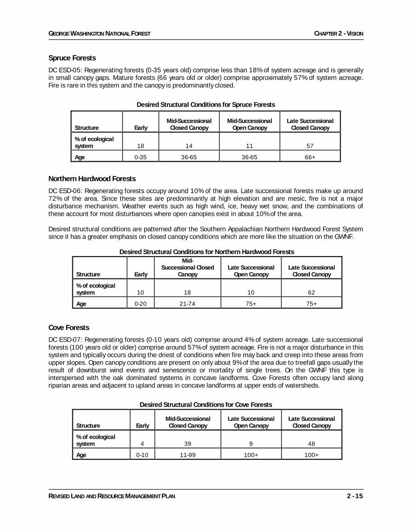
Spruce Forests
DC ESD-05: Regenerating forests (0-35 years old) comprise less than 18% of system acreage and is generally in small canopy gaps. Mature forests (66 years old or older) comprise approximately 57% of system acreage. Fire is rare in this system and the canopy is predominantly closed.
Desired Structural Conditions for Spruce Forests
Northern Hardwood Forests
DC ESD-06: Regenerating forests occupy around 10% of the area. Late successional forests make up around 72% of the area. Since these sites are predominantly at high elevation and are mesic, fire is not a major disturbance mechanism. Weather events such as high wind, ice, heavy wet snow, and the combinations of these account for most disturbances where open canopies exist in about 10% of the area. Desired structural conditions are patterned after the Southern Appalachian Northern Hardwood Forest System since it has a greater emphasis on closed canopy conditions which are more like the situation on the GWNF.
Desired Structural Conditions for Northern Hardwood Forests
Structure Early
Mid- Successional Closed
Canopy Late Successional
Open Canopy Late Successional
Closed Canopy
% of ecological system 10 18 10 62
Age 0-20 21-74 75+ 75+ Cove Forests
DC ESD-07: Regenerating forests (0-10 years old) comprise around 4% of system acreage. Late successional forests (100 years old or older) comprise around 57% of system acreage. Fire is not a major disturbance in this system and typically occurs during the driest of conditions when fire may back and creep into these areas from upper slopes. Open canopy conditions are present on only about 9% of the area due to treefall gaps usually the result of downburst wind events and senescence or mortality of single trees. On the GWNF this type is interspersed with the oak dominated systems in concave landforms. Cove Forests often occupy land along riparian areas and adjacent to upland areas in concave landforms at upper ends of watersheds.
Desired Structural Conditions for Cove Forests
Structure Early Mid-Successional
Closed Canopy Late Successional
Open Canopy Late Successional
Closed Canopy
% of ecological system 4 39 9 48
Age 0-10 11-99 100+ 100+
Structure Early Mid-Successional
Closed Canopy Mid-Successional
Open Canopy Late Successional
Closed Canopy
% of ecological system 18 14 11 57
Age 0-35 36-65 36-65 66+
CHAPTER 2 – VISION GEORGE WASHINGTON NATIONAL FOREST
2 - 16 REVISED LAND AND RESOURCE MANAGEMENT PLAN
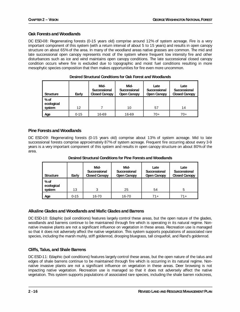
Oak Forests and Woodlands
DC ESD-08: Regenerating forests (0-15 years old) comprise around 12% of system acreage. Fire is a very important component of this system (with a return interval of about 5 to 15 years) and results in open canopy structure on about 65% of the area. In many of the woodland areas native grasses are common. The mid and late successional open canopy represents most of the system where frequent low intensity fire and other disturbances such as ice and wind maintains open canopy conditions. The late successional closed canopy condition occurs where fire is excluded due to topographic and moist fuel conditions resulting in more mesophytic species composition that then makes opportunities for fire even more uncommon.
Desired Structural Conditions for Oak Forest and Woodlands Pine Forests and Woodlands
DC ESD-09: Regenerating forests (0-15 years old) comprise about 13% of system acreage. Mid to late successional forests comprise approximately 87% of system acreage. Frequent fire occurring about every 3-9 years is a very important component of this system and results in open canopy structure on about 80% of the area.
Desired Structural Conditions for Pine Forests and Woodlands
Alkaline Glades and Woodlands and Mafic Glades and Barrens
DC ESD-10: Edaphic (soil conditions) features largely control these areas, but the open nature of the glades, woodlands and barrens continue to be maintained through fire which is operating in its natural regime. Non-native invasive plants are not a significant influence on vegetation in these areas. Recreation use is managed so that it does not adversely affect the native vegetation. This system supports populations of associated rare species, including the marsh muhly, stiff goldenrod, drooping bluegrass, tall cinquefoil, and Rand's goldenrod. Cliffs, Talus, and Shale Barrens
DC ESD-11: Edaphic (soil conditions) features largely control these areas, but the open nature of the talus and edges of shale barrens continue to be maintained through fire which is occurring in its natural regime. Non-native invasive plants are not a significant influence on vegetation in these areas. Deer browsing is not impacting native vegetation. Recreation use is managed so that it does not adversely affect the native vegetation. This system supports populations of associated rare species, including the shale barren rockcress,
Structure Early
Mid-Successional
Closed Canopy
Mid-Successional Open Canopy
Late Successional Open Canopy
Late Successional
Closed Canopy
% of ecological system 12 7 10 57 14
Age 0-15 16-69 16-69 70+ 70+
Structure Early
Mid-Successional
Closed Canopy
Mid-Successional Open Canopy
Late Successional Open Canopy
Late Successional
Closed Canopy
% of ecological system 13 3 25 54 5
Age 0-15 16-70 16-70 71+ 71+
GEORGE WASHINGTON NATIONAL FOREST CHAPTER 2 - VISION
REVISED LAND AND RESOURCE MANAGEMENT PLAN 2 - 17
Millboro leatherflower, shale-barren blazing star, shale-barren evening primrose, Appalachian grizzled skipper, bristly sarsaparilla, chestnut lipfern, mountain sandwort, and three-toothed cinquefoil.
Floodplains, Wetlands and Riparian Areas
DC ESD-12: Regenerating forests (0-10 years old) are uncommon, though small openings are present and are important for key species. Open wetlands and open beaver meadows and ponds provide much of the open habitat conditions. Late successional forest is common and makes up most of the canopy. Fire is rare.
Caves and Karstlands
DC ESD-13: Caves and karstlands are protected both from recreational damage and from polluted water, which, in turn, protects the species that depend on them.
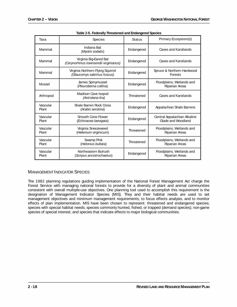
SPECIES DIVERSITY Background Maintaining a diversity of habitats for all species on the GWNF, especially threatened or endangered species, and enhancing wildlife habitat are important desired conditions. A diversity of plant and animal species is part of our natural heritage and provides forest visitors the opportunity to recreate in natural settings, view and study nature, hunt and fish. Forest lands serve as refuges for threatened, endangered and rare species, offer large contiguous forested areas where animal species can successfully reproduce and rear their young, offer key rest and feeding areas for migratory bird species, and provide important linkages (travel corridors) between State, Federal and other blocks of forested land. As part of a strategic plan for species diversity, the GWNF developed the Species Diversity Report (FEIS Appendix F) as a supplement to the Ecosystem Diversity Report, which describes how the ecological characteristics for ecosystems on the George Washington National Forest (GWNF) were identified and incorporated into the Plan. To assess species diversity, a comprehensive list of plant and animal species was compiled by combining species lists from a variety of sources. Federally threatened and endangered species (T&E), sensitive species, locally rare species and other species with management concerns (e.g., demand species) were identified and a total of 295 species were evaluated. Species were then linked to the terrestrial ecological systems. Where appropriate, species were grouped before linking them to systems. Many species needing differing habitat characteristics throughout their life cycle occurred in multiple groups. All species have at least some of their needs covered by ecosystem diversity, but some species required additional plan components based on their major limiting factors. These components are described in the Management Approach and Objectives section of Chapter 3 and in Standards in Chapter 4. THREATENED AND ENDANGERED SPECIES There are ten species listed by the Department of Interior, U.S. Fish and Wildlife Service (USFWS) as federally threatened or endangered that have been documented on or near the Forest. The USFWS is the agency responsible for listing T&E species on lands managed by the GWNF. Since the 1993 Plan, two birds (bald eagle & peregrine falcon) that occur on the Forest and were listed as endangered have been delisted by the Service. The Forest Service cooperates with USFWS efforts in conserving T&E species through protection and habitat management. The Forest Service conducts activities and programs to assist in the identification, conservation, and protection of threatened and endangered species and their habitats. Site-specific evaluations are conducted for any proposed activity that may take place within habitat for these species or near known populations. These ten species are further described in Table 2-5.
CHAPTER 2 – VISION GEORGE WASHINGTON NATIONAL FOREST
2 - 18 REVISED LAND AND RESOURCE MANAGEMENT PLAN
Table 2-5. Federally Threatened and Endangered Species
Taxa Species Status Primary Ecosystem(s)
Mammal Indiana Bat (Myotis sodalis) Endangered Caves and Karstlands
Mammal Virginia Big-Eared Bat (Corynorhinus townsendii virginianus) Endangered Caves and Karstlands
Mammal Virginia Northern Flying Squirrel (Glaucomys sabrinus fuscus) Endangered Spruce & Northern Hardwood
Forests
Mussel James Spinymussel (Pleurobema collina) Endangered Floodplains, Wetlands and
Riparian Areas
Arthropod Madison Cave Isopod (Antrolana lira) Threatened Caves and Karstlands
Vascular Plant
Shale Barren Rock Cress (Arabis serotina) Endangered Appalachian Shale Barrens
Vascular Plant
Smooth Cone Flower (Echinacea laevigata) Endangered Central Appalachian Alkaline
Glade and Woodland
Vascular Plant
Virginia Sneezeweed (Helenium virginicum) Threatened Floodplains, Wetlands and
Riparian Areas
Vascular Plant
Swamp Pink (Helonius bullata) Threatened Floodplains, Wetlands and
Riparian Areas
Vascular Plant
Northeastern Bulrush (Scirpus ancistrochaetus) Endangered Floodplains, Wetlands and
Riparian Areas
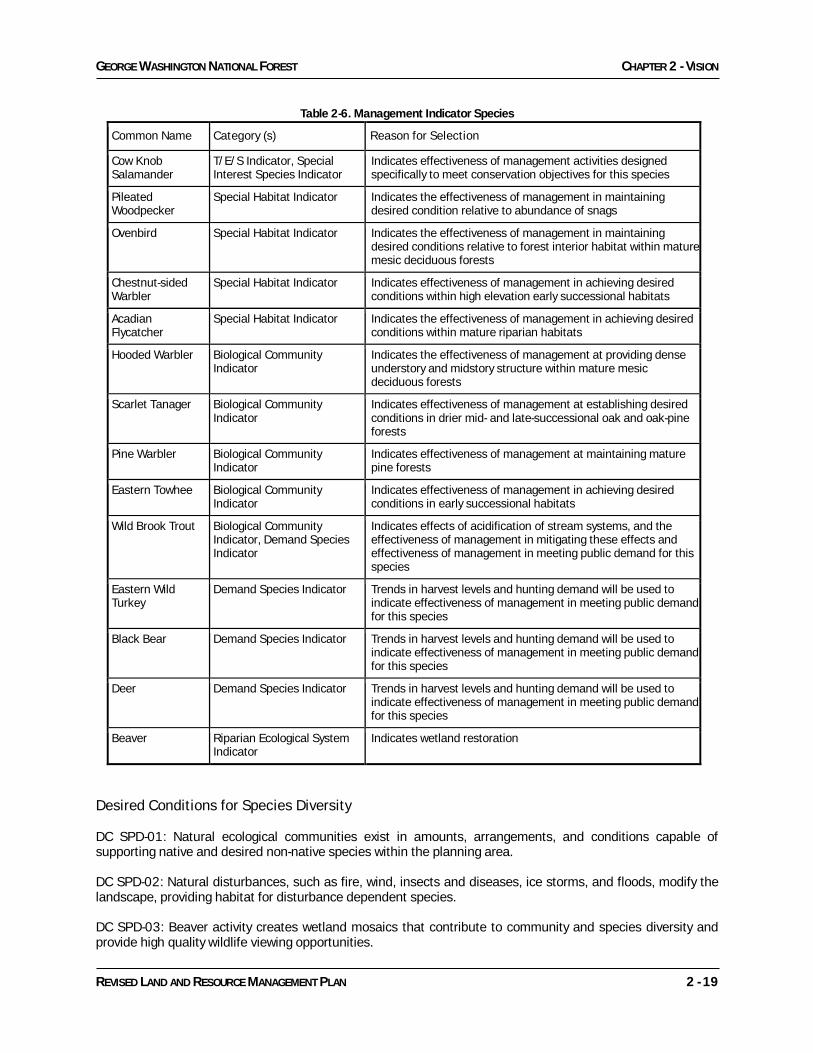
MANAGEMENT INDICATOR SPECIES The 1982 planning regulations guiding implementation of the National Forest Management Act charge the Forest Service with managing national forests to provide for a diversity of plant and animal communities consistent with overall multiple-use objectives. One planning tool used to accomplish this requirement is the designation of Management Indicator Species (MIS). They and their habitat needs are used to set management objectives and minimum management requirements, to focus effects analysis, and to monitor effects of plan implementation. MIS have been chosen to represent: threatened and endangered species; species with special habitat needs; species commonly hunted, fished, or trapped (demand species); non-game species of special interest; and species that indicate effects to major biological communities.
GEORGE WASHINGTON NATIONAL FOREST CHAPTER 2 - VISION
REVISED LAND AND RESOURCE MANAGEMENT PLAN 2 - 19
Table 2-6. Management Indicator Species
Common Name Category (s) Reason for Selection
Cow Knob Salamander
T/E/S Indicator, Special Interest Species Indicator
Indicates effectiveness of management activities designed specifically to meet conservation objectives for this species
Pileated Woodpecker
Special Habitat Indicator Indicates the effectiveness of management in maintaining desired condition relative to abundance of snags
Ovenbird Special Habitat Indicator Indicates the effectiveness of management in maintaining desired conditions relative to forest interior habitat within mature mesic deciduous forests
Chestnut-sided Warbler
Special Habitat Indicator Indicates effectiveness of management in achieving desired conditions within high elevation early successional habitats
Acadian Flycatcher
Special Habitat Indicator Indicates the effectiveness of management in achieving desired conditions within mature riparian habitats
Hooded Warbler Biological Community Indicator
Indicates the effectiveness of management at providing dense understory and midstory structure within mature mesic deciduous forests
Scarlet Tanager Biological Community Indicator
Indicates effectiveness of management at establishing desired conditions in drier mid- and late-successional oak and oak-pine forests
Pine Warbler Biological Community Indicator
Indicates effectiveness of management at maintaining mature pine forests
Eastern Towhee Biological Community Indicator
Indicates effectiveness of management in achieving desired conditions in early successional habitats
Wild Brook Trout Biological Community Indicator, Demand Species Indicator
Indicates effects of acidification of stream systems, and the effectiveness of management in mitigating these effects and effectiveness of management in meeting public demand for this species
Eastern Wild Turkey
Demand Species Indicator Trends in harvest levels and hunting demand will be used to indicate effectiveness of management in meeting public demand for this species
Black Bear Demand Species Indicator Trends in harvest levels and hunting demand will be used to indicate effectiveness of management in meeting public demand for this species
Deer Demand Species Indicator Trends in harvest levels and hunting demand will be used to indicate effectiveness of management in meeting public demand for this species
Beaver Riparian Ecological System Indicator
Indicates wetland restoration
Desired Conditions for Species Diversity DC SPD-01: Natural ecological communities exist in amounts, arrangements, and conditions capable of supporting native and desired non-native species within the planning area. DC SPD-02: Natural disturbances, such as fire, wind, insects and diseases, ice storms, and floods, modify the landscape, providing habitat for disturbance dependent species. DC SPD-03: Beaver activity creates wetland mosaics that contribute to community and species diversity and provide high quality wildlife viewing opportunities.
CHAPTER 2 – VISION GEORGE WASHINGTON NATIONAL FOREST
2 - 20 REVISED LAND AND RESOURCE MANAGEMENT PLAN
DC SPD-04: Diverse habitats exist that range from early successional forests to late successional forests, in both open and closed overstory conditions. These early, late, closed, and open conditions will provide habitat structure for a wide range of native plant and animal species. Diverse habitat is provided for known populations of threatened and endangered species, sensitive species and locally rare species on the Forest. DC SPD-05: Habitat for threatened and endangered species is provided to aid in recovery or movement towards recovery. Risks and threats are reduced or eliminated, especially during critical life stages such as nesting or raising offspring. The potential for sensitive species to become listed as threatened or endangered is reduced. DC SPD-06: Habitat is provided for species requiring a mosaic of forest types and structures for their life cycle needs, including black bear, ruffed grouse, wild turkey, and white-tailed deer. Larger areas of early successional habitat in the form of old fields, wildlife openings, pastoral areas, and regeneration areas provide habitat for species such as yellow-breasted chat, northern bobwhite, prairie warbler, white-eyed vireos, golden-winged warbler, and cotton-tailed rabbits. Habitat is also provided for species associated with areas of mid- to late-successional forests. In cove and mesic hardwood/pine forests with predominantly closed canopies, species needing large areas of mature trees with some level of overstory structural diversity (canopy gaps) are present, including cerulean warblers, worm-eating warblers, wood thrushes, hooded warblers, pileated woodpeckers, woodland salamanders, and eastern gray squirrels. In mature mesic and xeric pine/hardwood open woodlands with a mosaic of grass/forb/shrub understories, species needing large areas of both mature trees and an open structure are present, including golden-winged warblers, whip-poor-wills, scarlet tanagers, eastern wood pee-wees, northern flickers, Indiana bats and other tree and cave bats, fox squirrels, and timber rattlesnakes near rock outcrops. In addition, xeric pine/hardwood open woodlands provide habitat for post-breeding and migratory stop-over needs for birds species normally associated with forest interior habitat for breeding. Open oak woodlands near riparian areas and in valley bottoms provide habitat for species such as fox squirrels, woodcock, and wood turtles. DC SPD-07: Diverse breeding, wintering, migration, staging and stop-over diverse habitats for migratory species are provided in ways that contribute to their long-term conservation. DC SPD-08: Early successional habitat at higher elevations for high priority species like the golden-winged warbler and smooth green snake is present in the form of open woodlands, regenerating forests, and grasslands/shrublands. Patches of these habitats are clustered on the landscape to provide habitat for area-sensitive species. DC SPD-09: Some roads are seasonally inaccessible to motorized public travel to protect physical and biological resources and wildlife habitat. DC SPD-10: Snags, downed wood, stumps, and other organic matter occur in sufficient abundance to support native wildlife species. DC SPD-11: A combination of both dense shrub and relatively open understories exist across the landscape. Areas of blueberries, huckleberries, mountain laurel, and rhododendron are present. Hollow trees suitable for cavities and dens plus standing dead trees are common throughout the area. DC SPD-12: A blight-resistant American chestnut (Castanea dentata) is reestablished on the Forest as a dominant tree species. DC SPD-13: Watersheds with known populations of wood turtles are managed to maintain or enhance the terrestrial summer foraging habitat, nesting habitat and overwintering habitat of wood turtles. Human interactions, such as motorized vehicle use and recreation, are managed to minimize impacts to wood turtles.
GEORGE WASHINGTON NATIONAL FOREST CHAPTER 2 - VISION
REVISED LAND AND RESOURCE MANAGEMENT PLAN 2 - 21
OLD GROWTH Background The current amount and distribution of old growth (measured as the age of dominant overstory trees) on the Forest has been most influenced by management activities that preceded federal ownership. Natural disturbances, such as strong winds, large accumulations of ice, native insects and disease, wildfire and landslides, also affect old growth forest conditions, but they are regarded as being within the natural range of variability for forest successional dynamics. No plant or animal species in the Appalachians are known to require old growth forest conditions exclusively (i.e. are “old growth obligates”) for their survival or continued existence. Old growth forests are distinguished by not only old-age trees but also the presence of related structural attributes within the forest stand, such as large dead and down snags and gap-phase dynamics. The age at which a stand develops old growth attributes varies according to forest type (determined by dominant tree species) and reflects climate, site conditions (bedrock geology, soil type, aspect, moisture regime, elevation), and disturbance regime. The definitive characteristics for the different old growth forest types are contained in the document, “Guidance for Conserving and Restoring Old-Growth Forest Communities on National Forests in the Southern Region, Forestry Report R8-FR 62” and “Information about Old Growth for Selected Forest Type Groups in the Eastern United States, General Technical Report NC-197.” See also Appendix B - Old Growth Strategy for more information regarding old growth. Desired Conditions for Old Growth DC OLD-01: A well-distributed and representative network of large, medium, and small old growth patches is provided over time for biological and social benefits. These patches are expected to be embedded in a forest matrix dominated by mid and late successional forests. Old growth areas are generally interconnected by mature forests. DC OLD-02: On about 70,000 acres of Wilderness and Recommended Wilderness Study Areas, natural processes will determine the type of vegetation and structure of the old growth community. These landscapes feature a structurally diverse older aged forest community with occasional gaps created by disturbance events such as storms, insects, diseases, landslides, or wildland fire. These areas provide old growth characteristics in large blocks of land and contribute habitat for late successional, mature forest terrestrial and avian species. On about 350,000 acres of the forest (managed for Remote Backcountry recreation, Special Biological Areas, Research Natural Areas, National Scenic Areas, and Shenandoah Mountain Crest) predominantly natural processes will determine the type of vegetation and structure of the old growth community, though these areas will provide some additional areas of open woodland habitat since fire regimes will be within their historical range. These areas provide old growth characteristics in large blocks of land and contribute habitat for late successional, mature forest terrestrial and avian species. On the remainder of the forest, old growth conditions will be well dispersed predominantly in medium and small patches. FOREST HEALTH Background There are a number of forces that lead to forest disturbances. Some are a direct result of human activities, such as the introduction or spread of non-native organisms and continuous suppression of wildfires. Some are indirectly related to human activities, such as climate change. Still others result from such forces as extreme weather events. Disturbances may have positive impacts on various ecosystem components such as creation of canopy gaps for natural regeneration or input of woody material into the soil nutrient cycle or aquatic habitats. Yet the scale of some forest disturbances can be such that adverse impacts to some ecosystem components are significant. The social and economic benefits from salvaging dead and dying trees should be considered in addition to the benefits of leaving the trees as sources for soil nutrient recycling or large woody debris. Regardless of the cause of the disturbance, full consideration of both the beneficial and negative

CHAPTER 2 – VISION GEORGE WASHINGTON NATIONAL FOREST
2 - 22 REVISED LAND AND RESOURCE MANAGEMENT PLAN
impacts of the disturbance on the ecosystem and desired conditions for the area should be considered in determining a response, or lack of response, to a given disturbance event. As stated elsewhere in this document, the overarching principle will be to foster a resilient and healthy, primarily forested ecosystem that can absorb, or survive through, these disturbance events. The disturbances for discussion here include: insects, disease, non-native invasive plants, and non-native invasive aquatic species. Other aspects of forest health related to age, species diversity, and species composition are discussed in the desired conditions of Ecological Systems elsewhere in this chapter. Integrated Pest Management (IPM) principles are used during site-specific analysis. IPM is a decision-making and action process, which includes biological, economic, and environmental evaluation of host-pest systems to manage pest populations. IPM strategies involve a comprehensive systems approach to silvicultural, wildlife, fuel treatment, recreation and corridor management practices that emphasizes prevention of pest problems. Insect and disease organisms are a significant component of forest ecosystems. Native organisms contribute to many ecological processes of forests including nutrient cycling, plant succession, and forest dynamics. In most cases, these native organisms are recognized as an integral component of forest health. In a few instances, however, these organisms cause unacceptable resource damage or loss, and negatively affect ecological, economic, or social values. In these cases, the organisms causing the damage are referred to as pests. Significant native insect pests on the George Washington National Forest include the southern pine beetle and a variety of defoliators. Significant native disease problems include oak decline, shoe-string root rot, and a variety of other decay organisms affecting living trees. Often, problems from these pests are the result of other components of the ecosystem being outside the natural range of variability, such as the loss or lengthening of fire frequencies or the loss of predator organisms that keep these pests within acceptable population sizes. Throughout the past 100 years, a variety of insects, diseases, and plant species have been introduced to the United States and spread into the GWNF. These non-native organisms often are considered pests because they have no natural enemies or other naturally controlling agent and their unchecked spread can significantly damage native ecosystems and forest communities. Large areas of uniformly aged forests are particularly vulnerable to both native and non-native forest pest epidemics. The chestnut blight has reduced the American chestnut from a dominant tree species on this forest to a minor understory shrub. Other significant non-native pests include the gypsy moth, the hemlock woolly adelgid, beech bark disease, butternut canker, dogwood anthracnose and didymo. Non-native invasive plants are introduced species that can thrive in areas beyond their natural range. These plants are characteristically adaptable, aggressive, and have a high reproductive capacity. Their vigor combined with a lack of natural enemies often leads to population outbreaks. While not all non-native species are known to disrupt native ecosystems, of particular concern are those that are successful at invading and rapidly spreading through natural habitats. Numerous non-native invasive plants have been documented across the George Washington National Forest and many infested sites present an immediate threat to natural communities, rare species sites, and other sites of high public interest. Desired Conditions for Native and Non-Native Invasive Species DC NNI-01: A forest environment is provided where damage to natural resources from forest pests (any native or non-native invasive species including plants, animals, insects, and/or diseases) are minimized when such damage prevents the attainment of other natural resource objectives. DC NNI-02: New introductions of invasive species are minimized. DC NNI-03: New invasive species infestations are promptly detected and eliminated before establishment. DC NNI-04: Existing infestations of targeted invasive species are eradicated, controlled or contained.

GEORGE WASHINGTON NATIONAL FOREST CHAPTER 2 - VISION
REVISED LAND AND RESOURCE MANAGEMENT PLAN 2 - 23
DC NNI-05: Ecosystems impacted by invasive species have been effectively restored or rehabilitated to desired conditions and to conditions that reduce vulnerability to invasion or reinvasion by invasive species. DC NNI-06: Healthy native ecosystems, particularly those that support threatened, endangered and sensitive species, are maintained or restored such that non-native organisms do not adversely impact the function of ecosystem processes. DC NNI-07: The integrity of rare natural communities is protected from native and non-native invasive plant species, such as ailanthus (tree of heaven), kudzu, multiflora rose, and autumn olive. Non-native invasive species are not a demonstrable threat to the integrity of other natural communities. FIRE Background Fire has played a major role in shaping vegetation communities in the Appalachian Mountains. Of all the natural disturbances that influence and shape ecosystems in our area, fire is perhaps the one humans have had the most influence over, both in suppressing and causing. Recent studies on the Forest and elsewhere in the Appalachians have analyzed the historic role of fire in our ecosystems. By examining basal fire scars in tree trunks using dendrochronology (study of tree rings) and microscopic charcoal in bog and pond sediments, it has been shown that fire was widespread and occurred frequently across our landscape. For example fire scar/tree ring studies at eight sites on or near the Forest show fires occurring at a frequency of approximately 3-9 years from the earliest chronology dates in the mid-1600s to mid-1700s and continued until the 1930s when fires began to be effectively and actively suppressed. Before European settlement, oak and oak-American chestnut forests on mesic slopes were maintained by a combination of lightning and human-set fires. Many communities and species require fire to sustain populations. Oak and southern yellow pine communities have been major components of these forests for thousands of years. These communities promote and require fire. Recurring fire has been a part of the ecosystem for thousands of years. Fire suppression, coupled with an array of other disturbances (e.g., logging and chestnut blight), has facilitated the increased dominance of shade-tolerant species such as red maple. Periodic prescribed burning can recreate the ecological role of fire in a controlled manner. A fire regime is the pattern of seasonality, frequency, and intensity of fire that prevails in an area. While fires may have been frequent on the landscape they do vary greatly in their intensity and effects within and between vegetation types. The drier ridgetops and south to west facing slopes typically dominated by pine and some dry-site oaks had the most frequent and intense fires while the cove and riparian areas with species such as yellow poplar and hemlock had less frequent and very low intensity fires. Typically fires on the upper drier slopes would be naturally extinguished as they burned into the cool moist habitats in coves and along streams. Generally speaking across the Forest, approximately 80% of the acreage had frequent fire while 20% had infrequent and low intensity fire based on forest types. Fire management strategies support a variety of desired conditions and objectives across the GWNF (e.g., to establish, maintain, control or restore forest vegetation, wildlife openings, open woodlands). The fire program includes determining the response to wildfires (both human-caused and lightning), using prescribed fire to reduce risk of damaging high intensity fires, reestablishing historic fire regimes, and restoring native ecosystems along with the plant and animal species those conditions support. Wildfires in our area that result from human-caused ignitions have two seasonal peaks, the highest one in April and a lower one in November. These months correspond with weather and fuel conditions that are conducive to easy fire ignition and spread (dry, low humidity, windy and no canopy cover of leaves). Lightning caused fires begin in April and peak from May to July then taper off in September. Most fires are the result of human ignitions, but lightning caused fires range from 12% to almost 45% depending on weather and fuel conditions.
CHAPTER 2 – VISION GEORGE WASHINGTON NATIONAL FOREST
2 - 24 REVISED LAND AND RESOURCE MANAGEMENT PLAN
Destructive wildfire can cross and affect all lands and resources regardless of jurisdiction and ownership. With almost 3,000 miles of property boundary line, the GWNF borders a mix of ownerships with residences and personal property, infrastructure, and other high value resources within the wildland urban interface. Above all else in the management of fire is the priority for firefighter and public safety. Desired Conditions for Fire DC FRE-01: The forest, influenced by both past climatic and human forces, is a forest with diversity and resiliency that is well-adapted to fire occurrence. Many native oak species and yellow pines continue to be major components. DC FRE-02: Wildland fire that results from natural ignitions (lightning) functions in its natural ecological role as nearly as possible, while life and property (public and private) are protected and critical resource values, including soil, air, and water quality, are maintained with no long-term negative impacts. DC FRE-03: The risk of losing key ecosystem components from the occurrence of high severity wildfire remains relatively low. DC FRE-04: Fire is used in a controlled, well-planned manner to manage vegetation, restore fire-dependent ecosystems and species, create desired wildlife habitat conditions, and modify uncharacteristic fuel conditions resulting from extended absence of fire and/or tree mortality from non-native insects and disease. DC FRE-05: Prescribed burning occurs under specific preplanned conditions, considering social concerns with smoke management, public health and safety, and welfare of private property. DC FRE-06: Wildland urban interface areas have a low risk of destructive wildfire. These areas are managed to reduce the risk of loss of human life, enhance protection of nearby homes and improvements, and provide an area where firefighters can safely conduct tactical operations to stop the spread of a wildland fire. RECREATION, SCENERY AND CULTURAL RESOURCES RECREATION Background Recreation has been a significant offering of the George Washington National Forest since its designation. Outdoor enthusiasts were drawn to the vast forested lands of the national forest for hunting, fishing, camping, hiking and horseback riding, and later mountain bicycling. As these different user groups demanded additional opportunities, the trail network on the National Forest exploded until it topped 1,000 miles. By the time of the last Plan Revision (1993), the Forest could no longer meet demand for single use trails and, with few exceptions, designated all trails as non-motorized, multiple-use trails. Since then, the various user groups and volunteer organizations have made significant strides in cooperating in their use and maintenance of these trails. The primary exception to multiple-use trails is the Appalachian National Scenic Trail (AT). The AT was congressionally-designated as a hiker only trail. For policy development and maintenance of the AT, there is a cooperative management system comprised of the federal land managing agencies, the Appalachian Trail Conservancy, and the individual volunteer trail clubs. The AT has a reputation throughout the world as a premier long-distance hiking trail and serves as a model for successful partnerships. The George Washington National Forest is also a provider of some of the most primitive, dispersed recreation in Virginia. There are designated Wildernesses and additional remote backcountry areas outside of Wilderness. In these areas, users can find solitude and must rely heavily on their own outdoor skills and abilities.

GEORGE WASHINGTON NATIONAL FOREST CHAPTER 2 - VISION
REVISED LAND AND RESOURCE MANAGEMENT PLAN 2 - 25
On the other end of the spectrum, the GWNF offers numerous front-country, developed recreation opportunities. After several recreation areas were constructed by the Civilian Conservation Corps, some of which are still enjoyed today, the developed recreation program really took root. Since that time, developed recreation has grown to include family campgrounds, group campgrounds, equestrian campgrounds, family picnic areas, group picnic areas, swimming beaches, boat ramps and launches, interpretive sites, shooting ranges and a designated Forest Service Scenic Byway. Improvements or expansion of existing recreation facilities and trails, and proposals for new facilities and trails, are screened and analyzed not only against the capability of the physical environment, but also the Forest’s financial capability to maintain and sustain its massive recreation program. The George Washington National Forest will work collaboratively with partners and the public in aligning our offering of recreation facilities and opportunities with public demand and desires as well as to achieve financial and environmental sustainability. Desired Conditions for Recreation DC REC-01: The Forest provides spectacular scenery, unique ecosystems and adequate access for the American public to use and enjoy the resources and opportunities available. The Forest provides escapes from the urban environment and the rural lands are the "backyard" playgrounds and tourism attractions for many smaller communities. A spectrum of high quality, nature-based outdoor recreation opportunities that reflect the exceptional resources of the Forest and interests of the recreating public are provided in an environmentally sound and financially sustainable basis. The rugged mountain landscapes make premier sightseeing and trail use the focus of recreation. DC REC-02: Recreational activities contribute to the sustainability of the social and economic values of local communities. DC REC-03: Transportation infrastructure (interstates; the Blue Ridge Parkway; roads; trails, including the Appalachian National Scenic Trail) facilitates access that is appropriate for the recreation opportunity setting. DC REC-04: Seasonal flora, waterfalls, streams, and lakes, wildlife, and pristine scenery set the stage for a wide availability and variety of quality outdoor recreation experiences. Lakes, streams, upland forests, and historic sites provide the attraction for day and overnight camping visits by urban recreationists. DC REC-05: Most of the Forest provides the opportunities for hunting, fishing, camping, and other quality outdoor dispersed recreation experiences. There are many opportunities for visitors to learn about natural and cultural resources and how to recreate responsibly. DC REC-06: A variety of motorized and non-motorized recreation opportunities are available at different levels of challenge. DC REC-07: Solitude and primitive recreation experiences are available in wilderness and remote backcountry settings and offer physical challenges with minimal human encounters. DC REC-08: The general forest area provides a variety of dispersed recreational opportunities (hunting, fishing, driving for pleasure, nature viewing, trails use, etc.). The setting is generally natural appearing, although forest management activities are present. Game and non-game wildlife populations are abundant and support viewing, photography, nature study, and hunting. Many areas of solitude and quiet are found. DC REC-09: Roads are managed to provide a variety of motorized recreation opportunities for licensed off-highway vehicles to enjoy driving in natural appearing settings. Some roads are maintained for high clearance vehicles. These roads are managed and monitored to absorb moderate to high levels of use while protecting soil, water, and air resource conditions. Roads may be closed seasonally or during inclement weather to protect resources.
CHAPTER 2 – VISION GEORGE WASHINGTON NATIONAL FOREST
2 - 26 REVISED LAND AND RESOURCE MANAGEMENT PLAN
RECREATION SETTINGS (RECREATION OPPORTUNITY SPECTRUM) Background A recreation opportunity is defined as “the availability of a real choice for a user to participate in a preferred activity in a preferred setting, in order to realize desired experiences,” (USDA 1982). The Recreation Opportunity Spectrum (ROS) is a method used to categorize, evaluate, and monitor settings and opportunities based on the natural, managerial, and social environment. On National Forest System (NFS) lands five ROS classes apply that include: primitive (P); semi-primitive non-motorized (SPNM); semi-primitive motorized (SPM); roaded natural (RN); and rural (R). The urban class (U) is not appropriate on NFS lands and there are no primitive classes on the GWNF. Desired Conditions for Recreation Opportunity Spectrum Settings (ROS) DC REC-10: The Forest offers a variety of recreation opportunity settings ranging from the highly developed to remote. DC REC-11: The semi-primitive classes (SPM, SPNM) are characterized by predominantly natural or natural-appearing landscapes. The size of these areas gives a strong feeling of remoteness. Within these settings, there are ample opportunities to practice wildland skills and to achieve feelings of self-reliance. In these semi-primitive settings, the primary mode of travel is foot, mountain bike or horse. DC REC-12: For a semi-primitive non-motorized recreational opportunity (SPNM), the area is remote. Visitors feel that they are removed or at least distanced from the sights and sounds of human activity. Visitors can find solitude and serenity as well as opportunities for self-discovery, challenge and risk-taking. Access to this area is difficult where travel is by animal or is human-powered. Few opportunities for social interaction exist. Visitors rely on their own backcountry skills and abilities. Other than trails, no facilities are provided for the comfort and convenience of visitors. The land provides a high degree of naturalness with little or no evidence of human-made changes to the environment. Wilderness areas and remote backcountry recreation areas provide most of the SPNM opportunities. The area has high probability of isolation from sights of human activities though an occasional road, power line, or evidence of vegetation manipulation may be seen. DC REC-13: For a semi-primitive motorized recreational opportunity (SPM), motorized public access is compatible, but may be limited or nonexistent in some SPM areas. Roads open for public use are typically primitive with a maintenance level of 2. More often, public access is by foot, mountain bike or horse. There is a moderate degree of challenge, risk and self-reliance. SPM settings offer visitors some expectation of isolation from sights of human activities though an occasional road, power line, or evidence of vegetation manipulation may be seen. The likelihood for meeting other recreationists is generally low. Visitors may see gated roads or tank traps to regulate access into an area. Other than trails, recreation facilities are rare, limited to resource protection needs and designed to be unobtrusive on the landscape. The area can have a high degree of naturalness. Remote backcountry areas provide a large component of SPM, but SPM can also be found in areas spread throughout the Forest. DC REC-14: For a roaded natural (RN) recreational opportunity, the area is characterized by predominantly natural appearing landscapes with moderate evidence of the sights and sounds of man. Such evidence usually harmonizes with the natural environment. Motorized access is available. On or near motorized travelways, other national forest visitors may frequently be encountered due to concentrated use. As recreationists move away from motorized travelways within the RN areas, there is about equal probability to see other individuals or groups as to experience solitude. There are ample opportunities to have a high degree of interaction with the natural environment. RN areas often take on a mosaic of development from highly modified areas to pockets of unmodified lands. Developed recreation sites such as campgrounds, picnic areas, shooting ranges, boat launches, trailheads, and interpretive sites may be present within this setting for the enhancement of the visitors’ recreational experience or the protection of the site and resources.

GEORGE WASHINGTON NATIONAL FOREST CHAPTER 2 - VISION
REVISED LAND AND RESOURCE MANAGEMENT PLAN 2 - 27
DC REC-15: For a rural recreational opportunity (R), these areas are substantially modified although they do have natural appearing elements. Facilities are typically designed for a large number of people and roads are generally paved. Sights and sounds of other people are readily evident. The landscape is often dominated by human-caused geometric patterns; open spaces may dominate the landscape. Facilities are developed for user comfort such as pavement on roads and trails, and convenience amenities within campgrounds. Common facilities within this setting would be developed campgrounds day use facilities, interpretive sites and administrative facilities. Opportunities for solitude, challenge and risk are generally low. DISPERSED RECREATION (TRAILS) Background The George Washington National Forest is becoming an increasingly urban forest. In such close proximity to numerous cities (including Washington, DC, and northern Virginia), towns, colleges and universities, as well as smaller communities, this national forest is uniquely located to serve many people from all walks of life and with various recreation preferences. Each trail user group has expressed desire, and demand, for more miles of their respective favorite trail use, whether motorized or non-motorized, hiking, mountain biking or equestrian trails. During the 1993 Forest Plan revision process, it was determined that there are not enough acres or human resources available to meet the demand for single use trails. Therefore, the vast majority of the trails on the national forest was, and continues to be, designated as multiple or shared use trails. There are exceptions, of course, such as the hiker-only Appalachian National Scenic Trail, highly developed interpretive trails, and trails where resource damage or potential damage is a concern. Also, all-terrain vehicles are restricted to the three designated motorized trail areas on the GWNF (See Management Prescription Area 7C). Over the last 16 years, the various user groups have, for the most part, embraced the shared use trail systems. Some volunteer organizations with different recreation preferences now work cooperatively to get projects done and obtain grants for trail maintenance. By sharing trails, each non-motorized user group can enjoy hundreds of miles of trails within the national forest. The George Washington National Forest currently has about 1,100 miles of system trail. Forest Service trails are categorized by the intended maintenance level. A primitive trail is maintenance level 0 or 1 and may appear to be not much more than a deer path. The range goes up to maintenance level 5 which would be a relatively short paved trail that offers interpretive signs. The majority of trail miles fall in the 2-4 maintenance level range.
Desired Conditions for Dispersed Recreation (Trails) DC REC-16: The Forest provides trail opportunities for varied interests and skill levels ranging from quality day trips to long distance backpack or saddlepack trips. The trail program is managed from a forestwide perspective and opportunities are offered where they are most responsive to demand, minimize conflicts between recreation user types, and can be managed in an environmentally sustainable and operationally efficient manner. DC REC-17: Trails are provided across all Recreation Opportunity Spectrum classes that are found on the forest. A range of trail difficulty levels, easy to most difficult, exists as terrain and intended maintenance levels dictate. Visitors have choices between using a high maintenance level trail near the “frontcountry”, a primitive low maintenance trail in the “backcountry”, or a trail in the middle of the range. DC REC-18: Trails are provided for non-motorized uses such as hiking, horseback riding, mountain biking, and hunting and fishing access; and trails are provided for motorized uses such as all-terrain vehicles and motorcycles. Use of motorized trail vehicles is restricted to designated trails. Motorized trails are open to non-motorized uses.

CHAPTER 2 – VISION GEORGE WASHINGTON NATIONAL FOREST
2 - 28 REVISED LAND AND RESOURCE MANAGEMENT PLAN
DC REC-19: For high maintenance level trails, the presence of other visitors is high. Where desired and the level of visitor use warrants, there are restroom facilities for the comfort of visitors. An information kiosk or bulletin board as well as other on-site signs provide clear directions and interpretive messages to and along the trail. These trails are accessible to all users. The trail difficulty rating is ‘easy’. There is little or no need to have special outdoor skills prior to using these trails. DC REC-20: For moderate maintenance level trails, there may be some encounters with other visitors, primarily at or near the trailhead. A vault toilet facility is provided at the trailhead only if needed for the protection of resources. Information boards at trailhead parking areas give some directional signs. Few signs exist along the trail to assure users they are still on the correct trail, to provide directions at an intersection with another trail or a road, and to give mileage to a destination. Blazes are painted along the route to help visitors follow the trail. The trail difficulty rating can range from easy to difficult. Users will be challenged and need to rely on their outdoor skills for trails rated moderate or difficult. DC REC-21: For low maintenance level trails, there will be few if any encounters with other visitors. A vault toilet facility is provided at the trailhead only if needed for the protection of resources. Information boards at trailhead parking areas give some directional signs, but few if any signs exist along the trail, primarily just at intersections. In non-Wilderness areas, trails are blazed. The trail difficulty rating is moderate to difficult. Visitors are afforded the opportunity to be self-reliant on their outdoor skills in an environment away from comfort and convenience amenities normally found in developed recreation areas. Possessing outdoor skills will be important for visitors in the remote portions of these areas. DC REC-22: A trail management objective (TMO) is completed for each trail and trails are managed and maintained in accordance with their specific TMOs. Volunteers play an important role in helping to maintain many popular trails. Through either individual or sponsored organization agreements, volunteers actively work with local district personnel to identify and address trail maintenance needs. LANDSCAPE AND SCENERY Background The Forest contains picturesque mountains and valleys of great scenic beauty. The majority of the Forest provides a natural-appearing landscape. The scenic and aesthetic values of the Forest are maintained by meeting Scenic Integrity Objectives (SIOs), using the Scenery Management System process. Scenic Integrity is a measure of the degree to which a natural or cultural landscape is visually perceived to be complete and intact, free from detractions from the natural or socially valued appearance. SIOs are classified as Very High, High, Moderate, Low, Very Low, or No Integrity. The Very Low and No Integrity SIOs are not adopted on the GWNF. The approximate acres of Scenic Integrity Objectives to be maintained are: Very High 45,000 acres, High 424,000 acres, Moderate 579,000 acres, and Low 17,000 acres. Desired Conditions for Scenery DC SCE-01: The mountainous George Washington National Forest provides many opportunities for high quality, nature-related scenic viewing and rural culture sightseeing and tourism. Numerous distinctively scenic and historic "special places" of a localized importance are available for people to enjoy. The Forest offers premier opportunities for scenic viewing from trails, roads, rivers and developed recreation sites. DC SCE-02: The desired conditions for scenery across the forest include intact, natural appearing, predominantly forested mountaintops and side slopes. The valleys are also predominantly forested except for openings for cultural or historic sites, pastoral areas, rivers, developed recreation areas, roads and administrative sites. These natural appearing landscapes include areas such as open woodlands, open wetlands, rock outcrops and talus slopes. Management activities in areas with SIO of Low may have scenery that appears moderately altered.
GEORGE WASHINGTON NATIONAL FOREST CHAPTER 2 - VISION
REVISED LAND AND RESOURCE MANAGEMENT PLAN 2 - 29
DC SCE-03: The Scenery Treatment Guide (Chapter 3, Table 3-3) and the scenic integrity objectives (SIO) within the standards of the Plan will provide guidance for mitigating scenery impacts for management activities during project planning and implementation. DC SCE-04: Disturbances to scenery allow for restoration of the landscape character that was influenced historically by wildfires. Within a variety of prescription areas, a landscape character theme includes a mosaic of openings that appear to have been created by natural wildfire, initially with blackened trees, shrubs, and ground-cover. Visual evidence of fire may persist for years; however, elements that are not natural appearing, such as mechanically constructed firelines, are not visually evident after one year of completing the project. These areas, where the role of fire is restored, have a long-term landscape character goal of predominantly canopied forest and woodland with natural appearing openings that contain a diversity of vegetative layers and species including grass/forbs and other groundcovers, understory, midstory and overstory trees. DC SCE-05: For a Very High (VH) SIO area, landscapes exist where the valued landscape character is intact and appears natural or unaltered with only minute visual disturbances to the valued scenery. The existing landscape character and sense of place is expressed at the highest possible level. VH generally provides only for ecological changes to be visible in natural landscapes and complete visual intactness of cultural landscapes. The SIO level is achieved immediately upon completion of any projects. DC SCE-06: For a High (H) SIO area, landscapes exist where the valued landscape character appears intact, natural and unaltered even though disturbances may be present. These deviations remain unnoticed to the casual observer because they have been designed to repeat attributes of form, line, color, texture and scale found in the valued scenery. This SIO level is achieved as soon after project completion as possible or within three years maximum. DC SCE-07: For a Moderate (M) SIO area, landscapes exist where the valued landscape character appears slightly altered. Noticeable human-created deviations are minor and remain visually subordinate to the landscape character being viewed, because they repeat its form, line, color, texture, pattern and scale. This SIO level is achieved as soon after project completion as possible or within three years maximum. DC SCE-08: For a Low (L) SIO area, landscapes exist where the valued landscape character appears moderately altered. Deviations begin to dominate the valued landscape character being viewed but they borrow valued attributes such as size, shape, edge effect, and pattern of natural openings.
CULTURAL RESOURCES Background The George Washington National Forest contains a multitude of sites representing past human events. The varieties of cultural resources are impressive and include those related to 14,000 years of Native American habitation, the Civil War, the early industrial revolution, and the Civilian Conservation Corps (CCC). Sites that can be visited include an antebellum mansion, breastworks, recreation areas constructed by the CCC and numerous ruins of 19th Century furnaces, to name a few. These sites provide forest visitors a valuable lesson in the history of these lands prior to federal ownership. National Forest lands have been called “the lands that nobody wanted”, but these cultural resources indicate that there were many people throughout history who struggled to survive or thrived making a living off of these lands. Desired Conditions for Cultural Resources DC CUL-01: Cultural resources are protected. Those resources that are particularly susceptible to vandalism or looting are not publicly identified on-site. Treatments or mitigating measures are taken to make public access difficult to cultural resources that are particularly vulnerable to vandalism or that require a higher level of protection. However, many cultural resources are openly available for public viewing. Those that are readily accessible along roadways or short trails are the subject of on-site interpretation in the form of signs or programs, and off-site interpretation provided on the forest’s webpage. These interpretive opportunities are

CHAPTER 2 – VISION GEORGE WASHINGTON NATIONAL FOREST
2 - 30 REVISED LAND AND RESOURCE MANAGEMENT PLAN
provided to enhance public understanding of and appreciation for the cultural history of the forest. Opportunities are also provided for the public to volunteer with the Passport in Time and other programs, assisting Forest Service archaeologists in a formal “dig” and documentation of a historic or pre-historic site on the national forest. DC CUL-02: Effective relationships are maintained with Federal, State, Tribal and local governments and historic preservation organizations with interests in the George Washington National Forest to ensure protection of cultural resources and to promote Heritage program efficiencies.
INFRASTRUCTURE – ROADS AND FACILITIES Background Facilities include buildings, kiosks, shelters, etc. located on the National Forest, as well as administrative offices and work centers in nearby towns and cities. There are about 1,800 miles of inventoried and classified National Forest System (NFS) roads currently within the GWNF. These include collector and local roads of various levels ranging from an Operational Maintenance Level (OML) of Basic Custodial Care to High Degree of User Comfort. The majority of road work currently performed on the Forest consists of reconstruction of existing roads. New roads are sometimes required, but typically, existing roads are reconstructed if their location and layout are suitable for the currently existing need and the existing layout provides for minimal risk of resource damage. It is also necessary, at times, to decommission roads that are no longer required or are causing damage to other natural resources. About 160 miles of road have been identified as potentially available for decommissioning. Two types of roads on the Forest are used predominantly for other than Forest access. One of these (about 50 miles) includes roads that access special use permits. The other type is used to travel through the Forest from a destination off the Forest to another location, also off Forest. Common examples include work and school commuters who use these roads as shortcut access to jobs or to school locations. In these cases, it is often more desirable to bring the road to minimum State standards and turn the road over to the respective State Departments of Transportation for maintenance. Without exception, the State Departments of Transportation are better equipped and better funded to provide a higher level of maintenance and service for these roads. This maximizes efficiency of application for the limited funding received by the Forest Service for road maintenance and allows for better maintenance of those access routes, which are predominantly used for through-Forest access. About 130 miles of this type of road have been identified. The road system needed on the GWNF to meet Forest access needs has been identified as about 1,477 miles, not including the special use roads and roads potentially available to become forest highways (turned over to the State). The following maintenance levels are provided to National Forest System roads.
Table 2-7. Operational Maintenance Levels of Forest Roads
Operational Maintenance Level Miles
Maintenance Level 1 – Closed, in storage for future use 151
Maintenance Level 2 - High Clearance, seasonal or administrative use 1,005
Maintenance Level 3 - Passenger Car 281
Maintenance Level 4 - Passenger Car, collector 32
Maintenance Level 5 - Passenger Car, 2-lane, paved, arterial 8
Grand Total 1,477
GEORGE WASHINGTON NATIONAL FOREST CHAPTER 2 - VISION
REVISED LAND AND RESOURCE MANAGEMENT PLAN 2 - 31
Desired Conditions for Roads and Facilities DC RDF-01: A minimal transportation system is provided that supplies safe and efficient access to the GWNF for forest users while protecting forest resources. The desire for motorized access to the Forest is balanced against conflicting goals of providing for certain types of diverse wildlife habitat and non-motorized recreation use. Roads serve a variety of needs including access for recreational purposes, fire protection, vegetation and wildlife management, access to facilities, access to private land inholdings, and energy and mineral development. DC RDF-02: Public motorized access occurs only on designated roads and trails and as indicated on the Motorized Vehicle Use Map (MVUM). Motor vehicle designations include parking along designated routes and at facilities associated with designated routes when it is safe to do so and when not causing damage to National Forest System resources. DC RDF-03: Roads that are no longer needed have been decommissioned. Roads that are not needed for an extended period of time have been closed, stabilized and have native vegetation cover. DC RDF-04: Permanent vegetation is established on roadbeds of intermittent service roads. Cut and fill slopes of all roads have permanent vegetation established. DC RDF-05: Facilities reflect the natural and cultural landscape, and provide optimal service to customers and cooperators. They are in good condition, safe, clean, structurally sound, energy efficient and accessible to all users. LANDS AND SPECIAL USES Background Special use authorizations provide for those private uses of Forest lands that are necessary to serve the public interest and which cannot be accommodated on non-Federal land. This includes Forest lands used for utility corridors and transmission lines, communication sites, military training activities, outfitter guides, organizational camps, and recreation special events such as fishing tournaments and marathons. These special uses serve a public benefit by providing for public access, transportation efficiency for commerce, a reliable supply of electricity, natural gas, and water, and a communication network. Generation of power from wind and solar energy may be national forest special uses of the future. Authorizations for access to private land across NFS land are considered special uses, as are recreational activities such as outfitting and guiding and competitive events such as fishing tournaments, foot races, horse endurance races, and mountain bike races. The utility corridors designated as Management Prescription Area 5C are linear areas 50 to 1,000 feet wide to accommodate access for maintenance and facilitate co-location of new utilities, and include all existing utility rights-of-way 50 feet wide and larger under special use permit. Local energy distribution lines are smaller in scope and are a part of the management area in which they are physically located. Communication sites are designated as Management Prescription Area 5B and are usually located on mountain and ridge tops. The Secretary of Agriculture is authorized to issue permits, leases, and/or easements for transportation and utility rights-of-way and communication uses on National Forest System lands by the Federal Land Policy and Management Act of 1976 (P.L. 94-579), and the Mineral Leasing Act of 1920, as amended (P.L. 66-146). The Lands program consists of the acquisition, disposal and exchange of lands to meet resource management needs as well as maintaining around 3,000 miles of landline boundary between National Forest System lands and private lands.
CHAPTER 2 – VISION GEORGE WASHINGTON NATIONAL FOREST
2 - 32 REVISED LAND AND RESOURCE MANAGEMENT PLAN
Desired Conditions for Lands, Special Uses, Communication Sites and Utility Corridors Lands DC LSU-01: National Forest System lands are consolidated and provide reasonable access and efficiency of land management. Encroachments are none to few. No isolated forest tracts without legal access exist. Many small National Forest tracts surrounded by private lands are generally accessible to the public. DC LSU-02: The majority of Forest lands identified for exchange are lands that are attractive to private individuals, thus allowing for acquisition of other desirable parcels. DC LSU-03: Lands identified for acquisition are primarily in-holdings or adjoining parcels which are partially surrounded by Forest lands which will aid in consolidating National Forest System lands. DC LSU-04: The Appalachian National Scenic Trail has legal access and is sufficiently protected from developments which would detract for the Trail experience. DC LSU-05: Landlines and property corners are established to Forest Service standards. Landlines are easily locatable and highly visible. DC LSU-06: Private land improvements are not constructed on National Forest System lands as a result of erroneous surveys. No land title claims or encroachments exist. Special Uses DC LSU-07: Special uses exist that serve a local, regional or national public benefit and need by providing for public access, transportation efficiency for commerce, military training, a reliable supply of electricity, natural gas, water and alternative forms of energy, competitive and non-competitive recreational events, outfitting and guiding services, and communication networks. DC LSU-08: Special uses occur that serve an individual (private) benefit by providing access to private land. DC LSU-09: The number and acreage of special use authorizations for individual (private) use do not increase rapidly over current numbers; with terminated uses tending to offset new uses. DC LSU-10: Existing flood control dams are maintained in good working order per provisions in the special use permit. DC LSU-11: The Virginia Power Bath County Pumped Storage Project remains operational. DC LSU-12: Wind energy applications are considered a request for a special use permit. Communication Sites DC LSU-13: Each site is developed and utilized to its greatest potential in order to reduce the need to develop additional sites. All users' equipment blends visually with forest surroundings. All users’ equipment and frequencies coexist. New equipment is as inconspicuous to the surrounding terrain as possible. Vegetation consists predominantly of low grasses and wildflowers with some native deciduous and evergreen shrubs and scattered trees. For the most part the areas are on gently rolling terrain, some with exposed surface rock, rock outcrops, and meandering streams. DC LSU-14: Obsolete sites have been rehabilitated and blend into the surrounding landscape with native vegetation.
GEORGE WASHINGTON NATIONAL FOREST CHAPTER 2 - VISION
REVISED LAND AND RESOURCE MANAGEMENT PLAN 2 - 33
Utility Corridors DC LSU-15: Each utility corridor is developed and utilized to its greatest potential in order to reduce the need to develop additional corridors. DC LSU-16: Utility corridors retain low growing vegetation which conforms to the safe operating requirements of the utility and which reduce surface water runoff and erosion. Vegetation consists predominantly of grasses and wildflowers, low-growing native deciduous and evergreen shrubs, low-growing trees like dogwood and redbud, and young, sapling-sized trees. These corridors also provide open habitat conditions for wildlife. TIMBER MANAGEMENT Background Timber and other wood products are a byproduct of habitat management activities as well as a purpose for timber management on lands suitable for production. The following desired conditions apply to lands suitable for timber production. Desired Conditions for Timber Management DC TIM-01: Forested stands are healthy, vigorous, of appropriate stocking levels and desirable species composition, and free to grow from competing less desirable trees on lands suitable for timber production. A regenerated forest stand contains tree species that commonly occur or have historically occurred naturally on similar sites within that ecosystem. Regenerated stands contribute to a variety of age classes and facilitate an even flow of wood products for societal use that benefit the local economy. DC TIM-02: Timber harvesting is used in a controlled, well-planned manner to manage vegetation, restore or create wildlife habitat conditions, reduce uncharacteristic fuel loads resulting from extended absence of fire and/or tree mortality from non-native insects and disease. DC TIM-03: On areas suitable for timber production, trees and the products derived from them are a highly valued forest resource, carefully managed to achieve the desired condition of a given area in a cost-effective manner. For societal use, forest products vary from high quality veneer and boards for furniture and flooring to small diameter pulp logs used in the production of paper, wood biomass energy, and personal use firewood. A stable supply of wood products contributes to the social and economic well-being of the people living in the area and helps maintain a way of life long associated with those living within the area. DC TIM-04: The ecological value of leaving dead, dying, and damaged trees as a natural part of the ecosystem is balanced with aesthetic desires and economic values of the timber resource that can be used for fuelwood, wood biomass energy, pulpwood, or sawtimber if removed prior to deterioration or its value being lost. MINERAL RESOURCES Background Congress authorized the National Forests to help meet public demand for energy and non-energy minerals. The National Forests and the Bureau of Land Management have wide-ranging, multiple benefit missions. Congress established the roles of the Forest Service and the Bureau of Land Management in implementing the federal leasable mineral program, which on the George Washington National Forest currently involves about 10,200 acres of federal oil and gas leasing. Since 1980 a few exploration wells have been drilled on the George Washington National Forest, but the wells did not find commercial deposits of oil and gas. New exploration targets, such as the Marcellus shale, are potential exploration targets in the future. The Forest also is authorized to manage building stone, landscaping rock, aggregate, rip rap, and other rock or earthen materials under the federal mineral materials program. The Forest uses mineral materials to meet

CHAPTER 2 – VISION GEORGE WASHINGTON NATIONAL FOREST
2 - 34 REVISED LAND AND RESOURCE MANAGEMENT PLAN
desired conditions for a wide variety of resource management. Mineral materials are essential to build and maintain the Forest’s roads, trails, and other infrastructure. Like firewood, mineral materials also may be sold to the public, and can be provided free to public agencies, such as state highway departments. A continuing supply of energy and non-energy minerals is essential to manage the Forest and for public use and enjoyment of the Forest. This continuous supply of minerals originates mostly from local, regional, national, and international sources off the Forest, but the Forest also has opportunities to supply a part of the minerals required to manage the Forest and for public use and enjoyment of the Forest. Desired Conditions for Mineral Resources DC MIN-01: The Forest's mineral resources help meet identified public demand for energy and non-energy minerals. DC MIN-02: The Forest's mineral materials (aggregate, rip rap, gabion rock, building stone, landscaping rock, etc.) are utilized to: help build and maintain trails, roads, campgrounds, and watershed improvement projects; control erosion and sedimentation; restore riparian and aquatic habitat; prevent or repair flood damage; for other uses to manage and sustain the Forest; and help meet public demand and other governmental agency needs. DC MIN-03: On National Forest System tracts where mineral rights are private (outstanding or reserved rights), the exercise of private mineral rights to explore and develop mineral resources is respected, and the Forest Plan direction is subject to the valid existing rights. When private mineral rights are exercised, operations are using only as much of the surface as is reasonably necessary and impacts to other resources are minimized. DC MIN-04: Looking across the Forest at all mineral operations, federal or private, the total area of ground disturbance from mineral operations is less than one-half of one percent of the Forest. DC MIN-05: All operations are reclaimed, and when possible, reclamation is used to enhance the desired condition for other resources, such as wildlife openings, ponds for wildlife, parking for recreation, staging area for firefighting and helicopters, etc. Reclamation also can be seen at historic abandoned mines. DC MIN-06: Collection of geologic materials for scientific or educational purposes and recreational rock hounding may occasionally be seen. RANGELAND RESOURCES Background There are currently three active grazing allotments: the Moody and Whiting Tracts along the Shenandoah River and the Zepp Tannery Tract on Cedar Creek. Desired Conditions for Rangeland Resources DC RGE-01: A landscape that includes pastoral landscapes and bottomland hardwoods exists. DC RGE-02: Healthy forage for domestic livestock and valuable grassland/shrubland habitat for various wildlife species is provided. DC RGE-03: Rangelands are not contributing to the degradation of water quality, aquatic species, or threatened, endangered or sensitive species habitat.