Embed Size (px)
Citation preview
WATCHTOWER Warwick, NY Project Description June 15, 2011 2-1
Chapter 2 Project Description
A. Introduction This Chapter provides a brief history of the Project Sponsor’s organization and existing operations in New York State, descriptions of the site location and the proposed project, and explanations of the Project Sponsor’s objectives and the need for the proposed project.
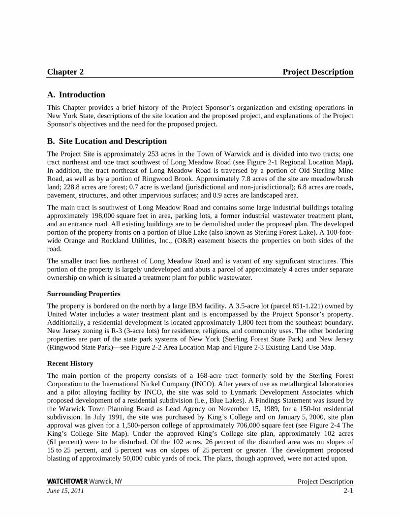
B. Site Location and Description The Project Site is approximately 253 acres in the Town of Warwick and is divided into two tracts; one tract northeast and one tract southwest of Long Meadow Road (see Figure 2-1 Regional Location Map). In addition, the tract northeast of Long Meadow Road is traversed by a portion of Old Sterling Mine Road, as well as by a portion of Ringwood Brook. Approximately 7.8 acres of the site are meadow/brush land; 228.8 acres are forest; 0.7 acre is wetland (jurisdictional and non-jurisdictional); 6.8 acres are roads, pavement, structures, and other impervious surfaces; and 8.9 acres are landscaped area.
The main tract is southwest of Long Meadow Road and contains some large industrial buildings totaling approximately 198,000 square feet in area, parking lots, a former industrial wastewater treatment plant, and an entrance road. All existing buildings are to be demolished under the proposed plan. The developed portion of the property fronts on a portion of Blue Lake (also known as Sterling Forest Lake). A 100-foot-wide Orange and Rockland Utilities, Inc., (O&R) easement bisects the properties on both sides of the road.
The smaller tract lies northeast of Long Meadow Road and is vacant of any significant structures. This portion of the property is largely undeveloped and abuts a parcel of approximately 4 acres under separate ownership on which is situated a treatment plant for public wastewater.
Surrounding Properties
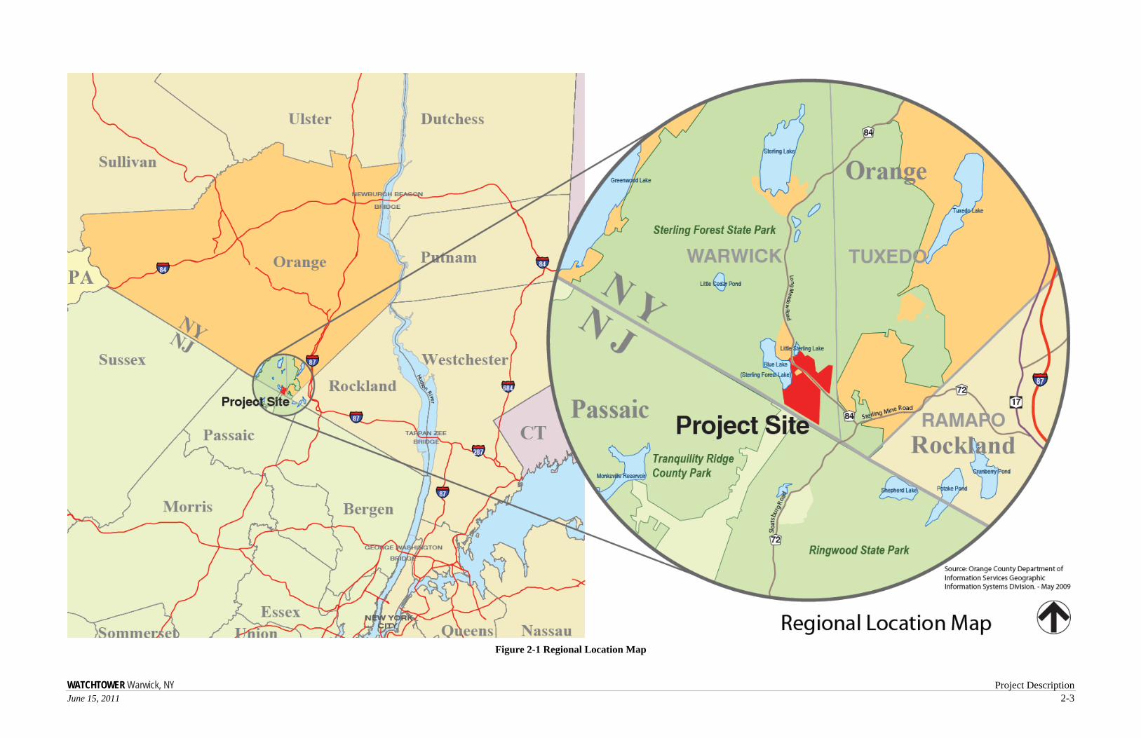
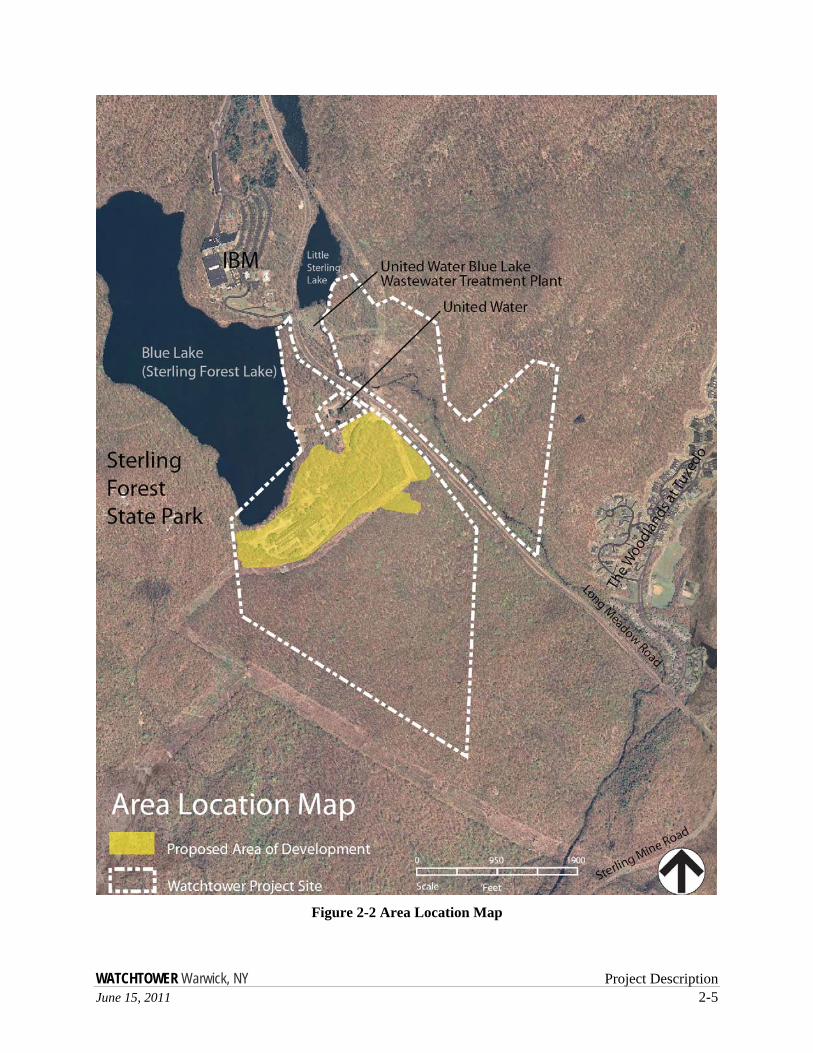
The property is bordered on the north by a large IBM facility. A 3.5-acre lot (parcel 851-1.221) owned by United Water includes a water treatment plant and is encompassed by the Project Sponsor’s property. Additionally, a residential development is located approximately 1,800 feet from the southeast boundary. New Jersey zoning is R-3 (3-acre lots) for residence, religious, and community uses. The other bordering properties are part of the state park systems of New York (Sterling Forest State Park) and New Jersey (Ringwood State Park)—see Figure 2-2 Area Location Map and Figure 2-3 Existing Land Use Map.
Recent History
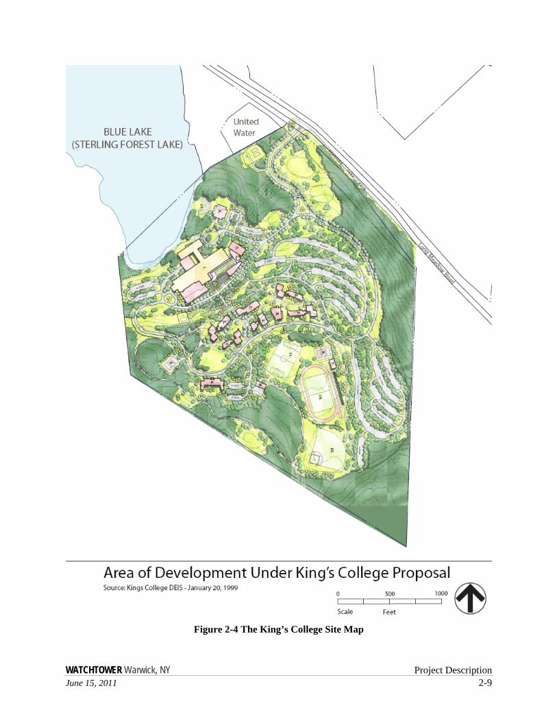
The main portion of the property consists of a 168-acre tract formerly sold by the Sterling Forest Corporation to the International Nickel Company (INCO). After years of use as metallurgical laboratories and a pilot alloying facility by INCO, the site was sold to Lynmark Development Associates which proposed development of a residential subdivision (i.e., Blue Lakes). A Findings Statement was issued by the Warwick Town Planning Board as Lead Agency on November 15, 1989, for a 150-lot residential subdivision. In July 1991, the site was purchased by King’s College and on January 5, 2000, site plan approval was given for a 1,500-person college of approximately 706,000 square feet (see Figure 2-4 The King’s College Site Map). Under the approved King’s College site plan, approximately 102 acres (61 percent) were to be disturbed. Of the 102 acres, 26 percent of the disturbed area was on slopes of 15 to 25 percent, and 5 percent was on slopes of 25 percent or greater. The development proposed blasting of approximately 50,000 cubic yards of rock. The plans, though approved, were not acted upon.

WATCHTOWER Warwick, NY Project Description June 15, 2011 2-3
Figure 2-1 Regional Location Map

WATCHTOWER Warwick, NY Project Description June 15, 2011 2-5
Figure 2-2 Area Location Map

WATCHTOWER Warwick, NY Project Description June 15, 2011 2-7
Figure 2-3 Existing Land Use Map

WATCHTOWER Warwick, NY Project Description June 15, 2011 2-9
Figure 2-4 The King’s College Site Map

WATCHTOWER Warwick, NY Project Description June 15, 2011 2-11
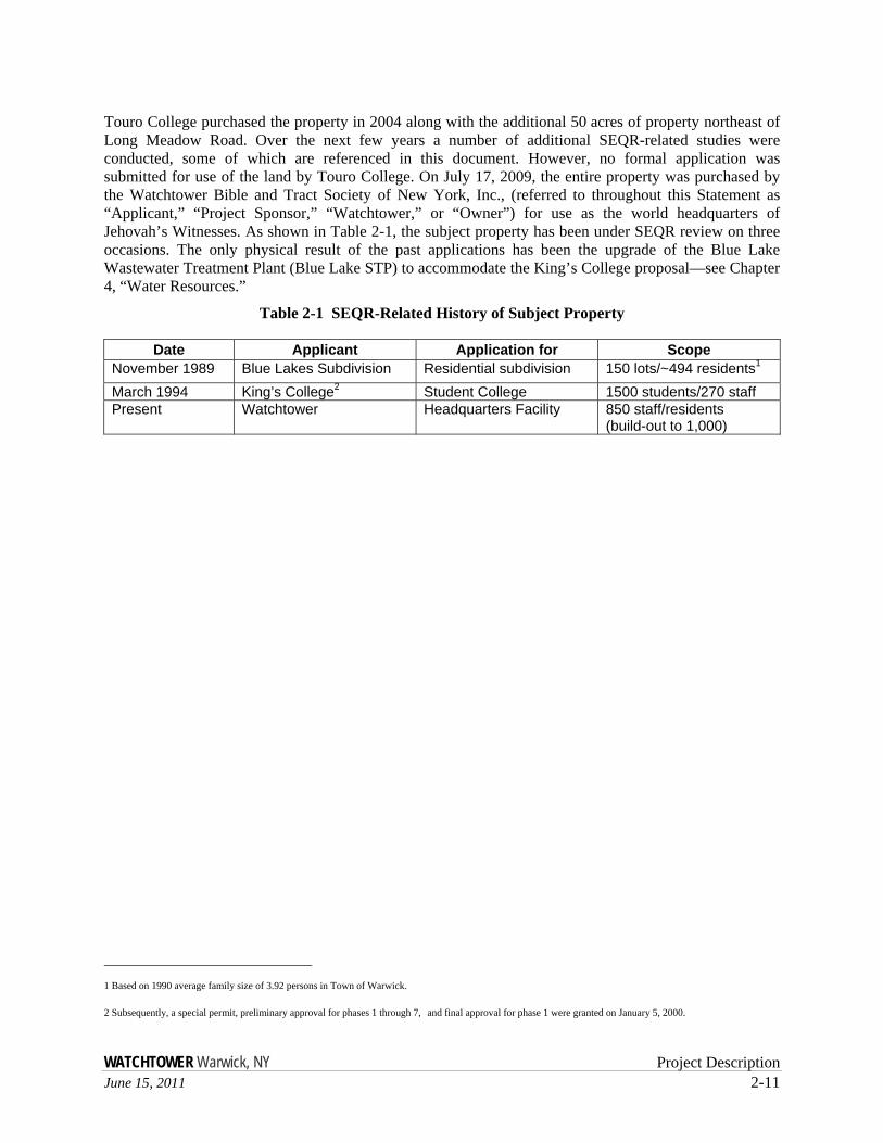
Touro College purchased the property in 2004 along with the additional 50 acres of property northeast of Long Meadow Road. Over the next few years a number of additional SEQR-related studies were conducted, some of which are referenced in this document. However, no formal application was submitted for use of the land by Touro College. On July 17, 2009, the entire property was purchased by the Watchtower Bible and Tract Society of New York, Inc., (referred to throughout this Statement as “Applicant,” “Project Sponsor,” “Watchtower,” or “Owner”) for use as the world headquarters of Jehovah’s Witnesses. As shown in Table 2-1, the subject property has been under SEQR review on three occasions. The only physical result of the past applications has been the upgrade of the Blue Lake Wastewater Treatment Plant (Blue Lake STP) to accommodate the King’s College proposal—see Chapter 4, “Water Resources.”
Table 2-1 SEQR-Related History of Subject Property
Date Applicant Application for Scope November 1989 Blue Lakes Subdivision Residential subdivision 150 lots/~494 residents1 March 1994 King’s College2 Student College 1500 students/270 staff Present Watchtower Headquarters Facility 850 staff/residents
(build-out to 1,000)
1 Based on 1990 average family size of 3.92 persons in Town of Warwick. 2 Subsequently, a special permit, preliminary approval for phases 1 through 7, and final approval for phase 1 were granted on January 5, 2000.
WATCHTOWER Warwick, NY 2-12 June 15, 2011
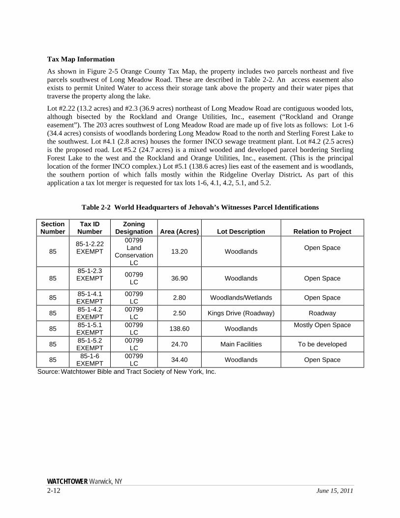
Tax Map Information
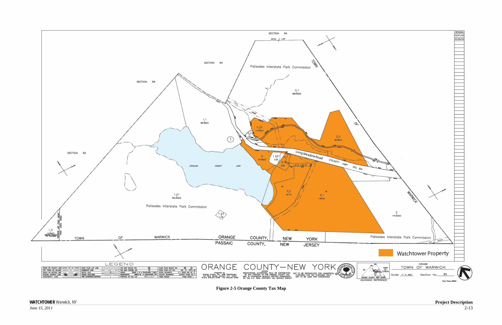
As shown in Figure 2-5 Orange County Tax Map, the property includes two parcels northeast and five parcels southwest of Long Meadow Road. These are described in Table 2-2. An access easement also exists to permit United Water to access their storage tank above the property and their water pipes that traverse the property along the lake.
Lot #2.22 (13.2 acres) and #2.3 (36.9 acres) northeast of Long Meadow Road are contiguous wooded lots, although bisected by the Rockland and Orange Utilities, Inc., easement (“Rockland and Orange easement”). The 203 acres southwest of Long Meadow Road are made up of five lots as follows: Lot 1-6 (34.4 acres) consists of woodlands bordering Long Meadow Road to the north and Sterling Forest Lake to the southwest. Lot #4.1 (2.8 acres) houses the former INCO sewage treatment plant. Lot #4.2 (2.5 acres) is the proposed road. Lot #5.2 (24.7 acres) is a mixed wooded and developed parcel bordering Sterling Forest Lake to the west and the Rockland and Orange Utilities, Inc., easement. (This is the principal location of the former INCO complex.) Lot #5.1 (138.6 acres) lies east of the easement and is woodlands, the southern portion of which falls mostly within the Ridgeline Overlay District. As part of this application a tax lot merger is requested for tax lots 1-6, 4.1, 4.2, 5.1, and 5.2.
Table 2-2 World Headquarters of Jehovah’s Witnesses Parcel Identifications
Section Number
Tax ID Number
Zoning Designation Area (Acres) Lot Description Relation to Project
85 85-1-2.22 EXEMPT
00799 Land
Conservation LC
13.20 Woodlands Open Space
85 85-1-2.3 EXEMPT
00799 LC 36.90 Woodlands Open Space
85 85-1-4.1 EXEMPT
00799 LC 2.80 Woodlands/Wetlands Open Space
85 85-1-4.2 EXEMPT
00799 LC 2.50 Kings Drive (Roadway) Roadway
85 85-1-5.1 EXEMPT
00799 LC 138.60 Woodlands Mostly Open Space
85 85-1-5.2 EXEMPT
00799 LC 24.70 Main Facilities To be developed
85 85-1-6 EXEMPT
00799 LC 34.40 Woodlands Open Space
Source: Watchtower Bible and Tract Society of New York, Inc.
WATCHTOWER Warwick, NY Project Description June 15, 2011 2-13
Figure 2-5 Orange County Tax Map

WATCHTOWER Warwick, NY Project Description June 15, 2011 2-15
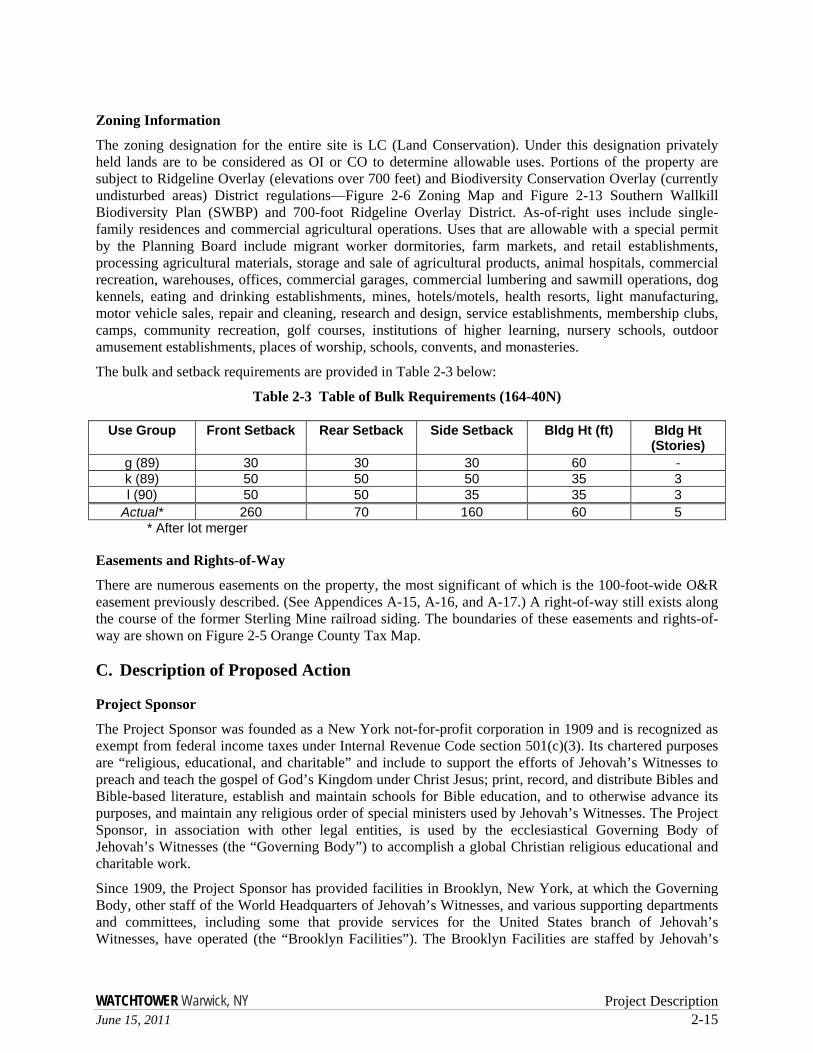
Zoning Information
The zoning designation for the entire site is LC (Land Conservation). Under this designation privately held lands are to be considered as OI or CO to determine allowable uses. Portions of the property are subject to Ridgeline Overlay (elevations over 700 feet) and Biodiversity Conservation Overlay (currently undisturbed areas) District regulations—Figure 2-6 Zoning Map and Figure 2-13 Southern Wallkill Biodiversity Plan (SWBP) and 700-foot Ridgeline Overlay District. As-of-right uses include single-family residences and commercial agricultural operations. Uses that are allowable with a special permit by the Planning Board include migrant worker dormitories, farm markets, and retail establishments, processing agricultural materials, storage and sale of agricultural products, animal hospitals, commercial recreation, warehouses, offices, commercial garages, commercial lumbering and sawmill operations, dog kennels, eating and drinking establishments, mines, hotels/motels, health resorts, light manufacturing, motor vehicle sales, repair and cleaning, research and design, service establishments, membership clubs, camps, community recreation, golf courses, institutions of higher learning, nursery schools, outdoor amusement establishments, places of worship, schools, convents, and monasteries.
The bulk and setback requirements are provided in Table 2-3 below:
Table 2-3 Table of Bulk Requirements (164-40N)
Use Group Front Setback Rear Setback Side Setback Bldg Ht (ft) Bldg Ht (Stories)
g (89) 30 30 30 60 - k (89) 50 50 50 35 3 l (90) 50 50 35 35 3
Actual* 260 70 160 60 5 * After lot merger
Easements and Rights-of-Way
There are numerous easements on the property, the most significant of which is the 100-foot-wide O&R easement previously described. (See Appendices A-15, A-16, and A-17.) A right-of-way still exists along the course of the former Sterling Mine railroad siding. The boundaries of these easements and rights-of-way are shown on Figure 2-5 Orange County Tax Map.
C. Description of Proposed Action
Project Sponsor
The Project Sponsor was founded as a New York not-for-profit corporation in 1909 and is recognized as exempt from federal income taxes under Internal Revenue Code section 501(c)(3). Its chartered purposes are “religious, educational, and charitable” and include to support the efforts of Jehovah’s Witnesses to preach and teach the gospel of God’s Kingdom under Christ Jesus; print, record, and distribute Bibles and Bible-based literature, establish and maintain schools for Bible education, and to otherwise advance its purposes, and maintain any religious order of special ministers used by Jehovah’s Witnesses. The Project Sponsor, in association with other legal entities, is used by the ecclesiastical Governing Body of Jehovah’s Witnesses (the “Governing Body”) to accomplish a global Christian religious educational and charitable work.
Since 1909, the Project Sponsor has provided facilities in Brooklyn, New York, at which the Governing Body, other staff of the World Headquarters of Jehovah’s Witnesses, and various supporting departments and committees, including some that provide services for the United States branch of Jehovah’s Witnesses, have operated (the “Brooklyn Facilities”). The Brooklyn Facilities are staffed by Jehovah’s

WATCHTOWER Warwick, NY 2-16 June 15, 2011
Witnesses who are members of the Worldwide Order. Members of the Worldwide Order perform their duties full-time without compensation, have chosen to live either unmarried or married without children, and have taken a simple vow of obedience and poverty. The personnel who serve the world headquarters and these other departments and committees, including maintenance, cleaning, housekeeping, and food service personnel, live at residence buildings that are part of the Brooklyn Facilities. Additionally, thousands of guests and visitors arrive annually to tour the facilities and see relatives or friends.
WATCHTOWER Warwick, NY Project Description June 15, 2011 2-17
Figure 2-6 Zoning Map

WATCHTOWER Warwick, NY Project Description June 15, 2011 2-19
In 2004, printing operations, including those previously carried on in Brooklyn, were consolidated to the Project Sponsor’s farm and printing facility near the hamlet of Wallkill in the Town of Shawangunk, New York. At Watchtower’s educational facility located in Patterson, New York, members of the Worldwide Order provide training to missionaries, ministers, and religious administrators and prepare audio, video, and visual artwork, provide translation services, and administer the congregations, assemblies, education, and public religious worship of Jehovah’s Witnesses in the United States.
All three existing facilities are staffed by members of the Worldwide Order.
As a result of discontinuing printing and related activities at the Brooklyn Facilities, related downsizing of staff at those facilities, and other organizational adjustments, the Brooklyn Facilities are too large for the activities now carried on there. Such changes make it feasible to relocate the world headquarters staff and others to a more rural, contemplative environment appropriate for the needs of the activities now remaining at the Brooklyn Facilities.
Proposed Action
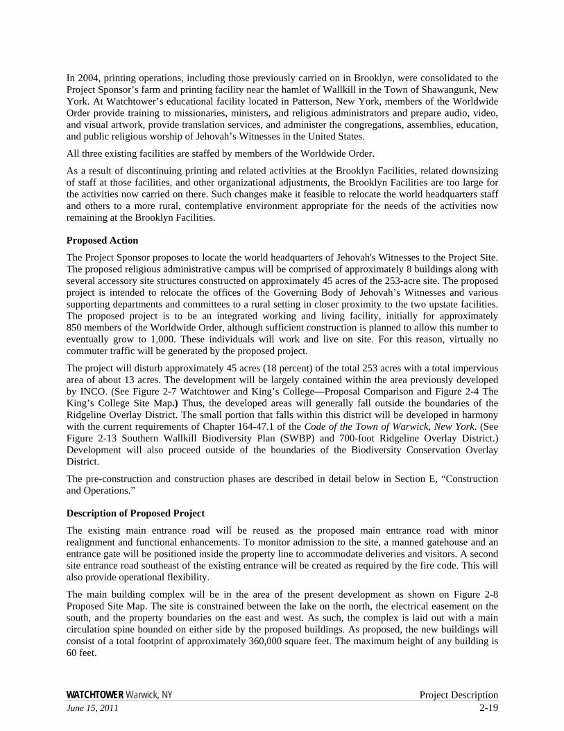
The Project Sponsor proposes to locate the world headquarters of Jehovah's Witnesses to the Project Site. The proposed religious administrative campus will be comprised of approximately 8 buildings along with several accessory site structures constructed on approximately 45 acres of the 253-acre site. The proposed project is intended to relocate the offices of the Governing Body of Jehovah’s Witnesses and various supporting departments and committees to a rural setting in closer proximity to the two upstate facilities. The proposed project is to be an integrated working and living facility, initially for approximately 850 members of the Worldwide Order, although sufficient construction is planned to allow this number to eventually grow to 1,000. These individuals will work and live on site. For this reason, virtually no commuter traffic will be generated by the proposed project.
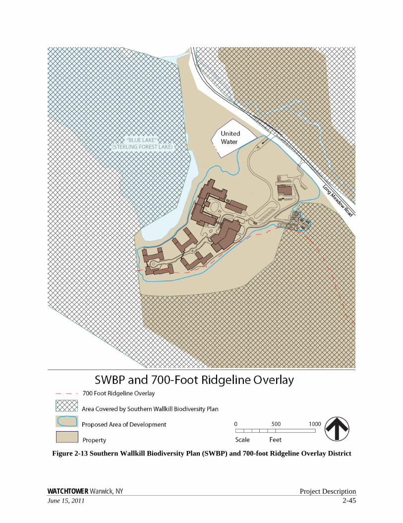
The project will disturb approximately 45 acres (18 percent) of the total 253 acres with a total impervious area of about 13 acres. The development will be largely contained within the area previously developed by INCO. (See Figure 2-7 Watchtower and King’s College—Proposal Comparison and Figure 2-4 The King’s College Site Map.) Thus, the developed areas will generally fall outside the boundaries of the Ridgeline Overlay District. The small portion that falls within this district will be developed in harmony with the current requirements of Chapter 164-47.1 of the Code of the Town of Warwick, New York. (See Figure 2-13 Southern Wallkill Biodiversity Plan (SWBP) and 700-foot Ridgeline Overlay District.) Development will also proceed outside of the boundaries of the Biodiversity Conservation Overlay District.
The pre-construction and construction phases are described in detail below in Section E, “Construction and Operations.”
Description of Proposed Project
The existing main entrance road will be reused as the proposed main entrance road with minor realignment and functional enhancements. To monitor admission to the site, a manned gatehouse and an entrance gate will be positioned inside the property line to accommodate deliveries and visitors. A second site entrance road southeast of the existing entrance will be created as required by the fire code. This will also provide operational flexibility.
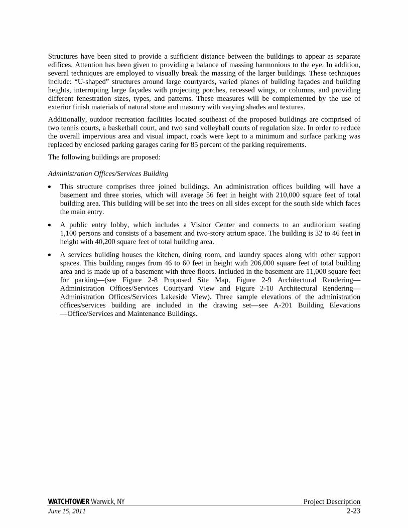
The main building complex will be in the area of the present development as shown on Figure 2-8 Proposed Site Map. The site is constrained between the lake on the north, the electrical easement on the south, and the property boundaries on the east and west. As such, the complex is laid out with a main circulation spine bounded on either side by the proposed buildings. As proposed, the new buildings will consist of a total footprint of approximately 360,000 square feet. The maximum height of any building is 60 feet.

WATCHTOWER Warwick, NY Project Description June 15, 2011 2-21
Figure 2-7 Watchtower and King’s College—Proposal Comparison

WATCHTOWER Warwick, NY Project Description June 15, 2011 2-23
Structures have been sited to provide a sufficient distance between the buildings to appear as separate edifices. Attention has been given to providing a balance of massing harmonious to the eye. In addition, several techniques are employed to visually break the massing of the larger buildings. These techniques include: “U-shaped” structures around large courtyards, varied planes of building façades and building heights, interrupting large façades with projecting porches, recessed wings, or columns, and providing different fenestration sizes, types, and patterns. These measures will be complemented by the use of exterior finish materials of natural stone and masonry with varying shades and textures.
Additionally, outdoor recreation facilities located southeast of the proposed buildings are comprised of two tennis courts, a basketball court, and two sand volleyball courts of regulation size. In order to reduce the overall impervious area and visual impact, roads were kept to a minimum and surface parking was replaced by enclosed parking garages caring for 85 percent of the parking requirements.
The following buildings are proposed:
Administration Offices/Services Building
• This structure comprises three joined buildings. An administration offices building will have a basement and three stories, which will average 56 feet in height with 210,000 square feet of total building area. This building will be set into the trees on all sides except for the south side which faces the main entry.
• A public entry lobby, which includes a Visitor Center and connects to an auditorium seating 1,100 persons and consists of a basement and two-story atrium space. The building is 32 to 46 feet in height with 40,200 square feet of total building area.
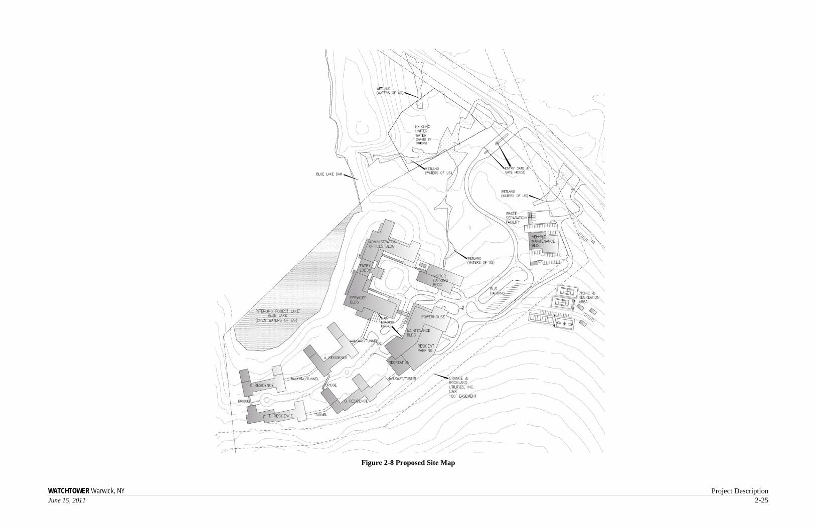
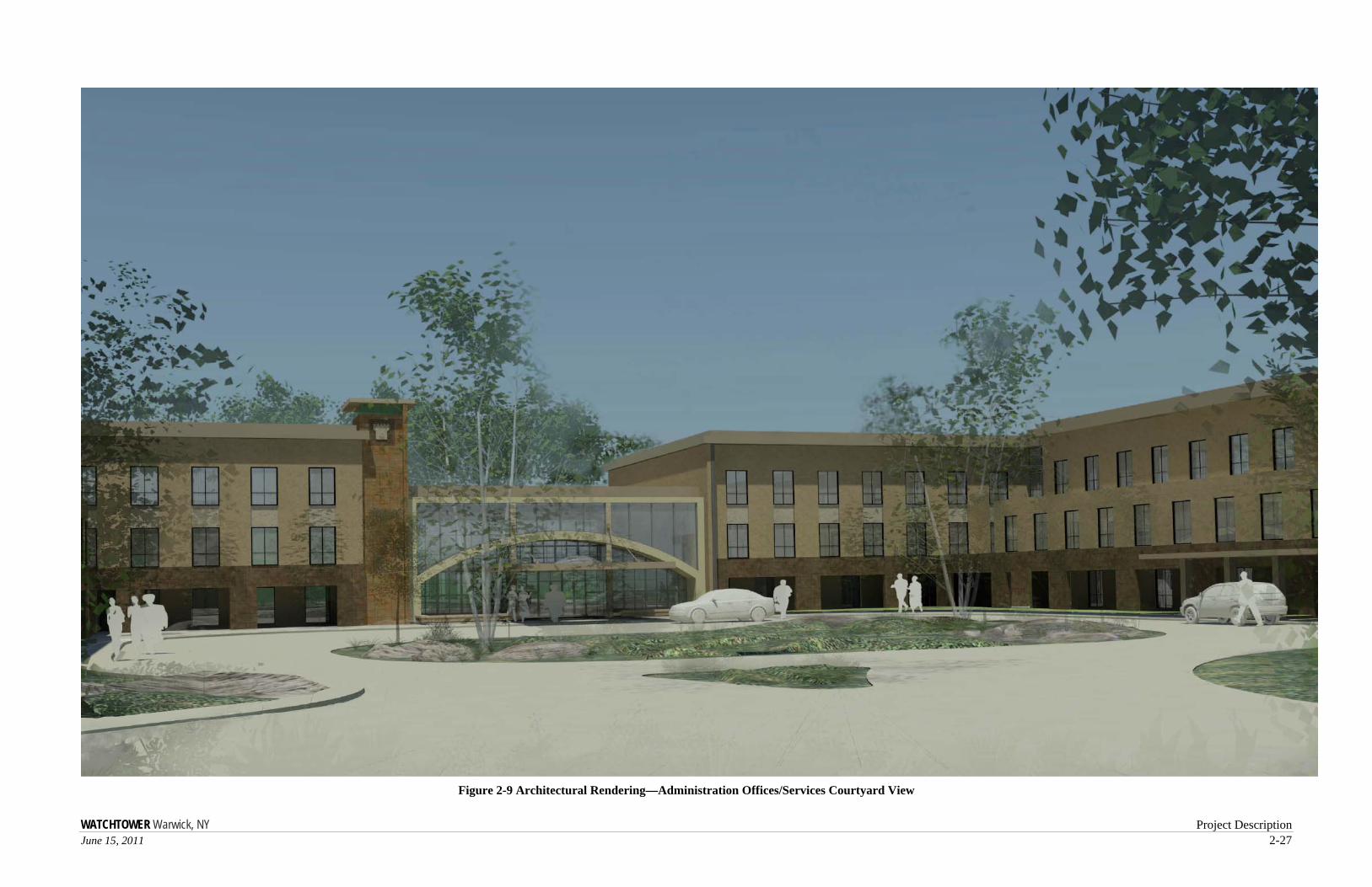
• A services building houses the kitchen, dining room, and laundry spaces along with other support spaces. This building ranges from 46 to 60 feet in height with 206,000 square feet of total building area and is made up of a basement with three floors. Included in the basement are 11,000 square feet for parking—(see Figure 2-8 Proposed Site Map, Figure 2-9 Architectural Rendering—Administration Offices/Services Courtyard View and Figure 2-10 Architectural Rendering—Administration Offices/Services Lakeside View). Three sample elevations of the administration offices/services building are included in the drawing set—see A-201 Building Elevations —Office/Services and Maintenance Buildings.

WATCHTOWER Warwick, NY Project Description June 15, 2011 2-25
Figure 2-8 Proposed Site Map

WATCHTOWER Warwick, NY Project Description June 15, 2011 2-27
Figure 2-9 Architectural Rendering—Administration Offices/Services Courtyard View

WATCHTOWER Warwick, NY Project Description June 15, 2011 2-29
Figure 2-10 Architectural Rendering—Administration Offices/Services Lakeside View

WATCHTOWER Warwick, NY Project Description June 15, 2011 2-31
Residence Buildings
• Four residence buildings, 30 to 58 feet in height with 494,000 square feet of total building area (see Figure 2-8 Proposed Site Map). The buildings generally have a basement with four floors above and contain a total of 588 residence rooms and support spaces. The residence rooms are “studio” or one-bedroom units ranging from 350 to 600 square feet including a kitchenette and private bathroom. Three sample elevations of Residence A are included in the drawing set—see Drawing A-202 Building Elevations—Residence A.
Maintenance Building/Resident Parking
• A maintenance and resident parking building with basement, varying from 15 to 52 feet in height with 427,000 square feet of total building area. 280,000 square feet of this space are for parking. Also included in the building footprint are the powerhouse and recreational facilities—see Figure 2-8 Proposed Site Map. One sample elevation of the maintenance building is included in the drawing set —see Drawing A-201 Building Elevations—Office/Services and Maintenance Buildings.
Vehicle Maintenance Building
• A maintenance building will be located between the main entrance road and the O&R easement and will be 30 to 46 feet in height with 35,000 square feet of total building area. The building consists of a basement with one or two floors above.
Visitor Parking
• A three-level partially enclosed below-ground parking garage with 240 parking spaces for visitors and 92,200 square feet of total building area.
Accessory Buildings
• Several small outbuildings, totaling less than 8,000 square feet, will be distributed within the general development area for recreation, waste separation, visitor conveniences, and maintenance areas.
Since the administration offices/services building is open to the public for guided tours, this building has been developed nearer to the main entry. The main loading docks are also developed near the main entrance to reduce vehicular traffic at the residential and recreational areas of the site, but are hidden from general public view. The residence buildings are located further from the main entrance in the more secluded and private area of the site. All major buildings are designed to take maximum advantage of lake views while minimizing the visual impact from areas outside of the site.
All of the proposed uses comply with existing zoning since places of worship, convents and monasteries, offices, and vehicle repair uses are allowed by special permit. Two zoning variances may be required for the project as noted in Table 2-5 Required Approvals.
Although the initial move-in is proposed to have 500 dwelling units for an initial move-in population of 850 persons, future expansion possibilities for a maximum of 588 and 1,000 persons will be built-in as part of the initial construction. The additional dwelling units are needed for residents’ guests and for turnover accommodations to allow for maintenance and upgrade of the units on an ongoing basis. The proposal is being designed in this manner in order to maintain the unified and compact nature of the proposal and to avoid future construction activities in the midst of a functioning site. No further expansion is planned beyond what is proposed as part of the present application.
WATCHTOWER Warwick, NY 2-32 June 15, 2011
Construction is proposed to begin upon completion of the permit process in 2012 and is anticipated to continue for approximately four years. The phases are described in detail in Section E, “Construction and Operations” below.
Landscaping
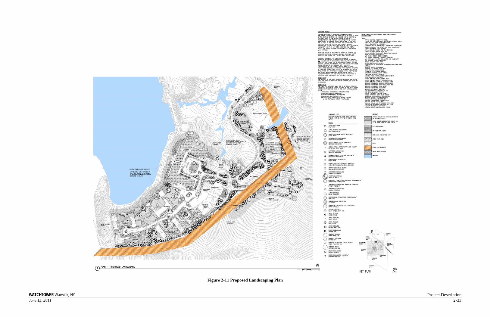
Clearing of existing vegetation around the site will be minimized. However, currently open areas including areas along the existing utility line easement, dam, and along Blue Lake will be maintained in an open unwooded character in order to maintain habitat for species that prefer this type of ecological community. The site’s remaining landscaping will be designed to be appropriate to the site’s location in a wooded area. Small ornamental planting areas and small retaining walls will make generous use of on-site boulders and stone. Any large retaining walls will be supplemented with green walls. No large lawn areas are planned. Only native plant species will be used for planting areas. The total impervious area will be limited to approximately 13 acres. The use of vegetated roofs will decrease the impervious area of the site by approximately 3.5 acres. Where heavy traffic is not anticipated, pervious paving as defined by the 2010 New York State Stormwater Management Design Manual will be used. Figure 2-11 Proposed Landscaping Plan shows how these elements will be included in the landscaping—see full-size drawing in Appendix L.
WATCHTOWER Warwick, NY Project Description June 15, 2011 2-33
Figure 2-11 Proposed Landscaping Plan

WATCHTOWER Warwick, NY Project Description June 15, 2011 2-35
Building Elevations of Proposed Development
The proposed new buildings have been designed in cooperation with the award-winning architectural firm of Perkins Eastman. Care was taken to develop an eco-friendly design which blends with the scenic rural environs while minimizing impact on precious habitats and wildlife. Views from Sterling Forest State Park were carefully analyzed. Impacts have been minimized by maintaining a small overall footprint, use of environmentally-friendly building materials and color shades and textures which blend well with the natural surroundings. Colors will be chosen in conformance with the Town's Biodiversity Color Chart (see Appendix I-4). The façade of each building will use natural materials. Complementary architectural features, such as a mix of sloped and vegetated roofs, punched windows, stepped buildings, and avoidance of long unbroken walls will enhance the overall appearance.
Proposed Utilities, Open Spaces, and Impervious Areas
The proposed project includes new distribution and collection piping, recreational amenities, open-space areas for common use by residents and visitors, parking, and driveways.
Water and sewer services to the site are to be provided by United Water’s facilities which occupy adjacent parcels. In their “Willingness to Serve” letter, United Water stated that 147,000 gpd can be made available for the Project Sponsor’s proposed use (see Appendix H-1). United Water has a Water Taking Permit for withdrawal from Blue Lake for 500,000 gpd. The rated capacity of the existing water plant is 650,000 gpd. The average daily demand on the plant is 119,000 gpd and maximum daily demand is 188,000 gpd. The plant presently supplies IBM, the Blue Lake STP, and Woodlands Development in addition to the Project Sponsor’s property.
Water consumption in the offices is anticipated to be less than 10 gallons per square foot per year, achieving the highest Green Globes™ points in this category. The residences will have lower-than-normal consumption through the use of low-flush toilets, water-saving or no-water urinals, water-saving faucets and shower heads, and other water conserving appliances and equipment.
Wastewater is to be handled by the Blue Lake STP, which was upgraded in 2002 to a 150,000-gpd plant with tertiary treatment (see Appendix A-9—“SPDES Permit” dated November 6, 2002). At present, the nearby IBM facility is the only user of this plant. United Water South County Sewer has confirmed that the proposed site has a maximum allotment of 130,000 gallons per day of available treatment capacity. However, a maximum average of 80,000 per day will be discharged due to the conservation measures outlined in Chapter 10, “Infrastructure and Utilities—Water Supply.”
Stormwater is to be handled in accordance with the 2010 New York State Stormwater Management Design Manual. Stormwater runoff reduction will be accomplished through the use of vegetated roofs, permeable paving, rainwater harvesting, rain gardens, bio-retention basins, and finally through riparian buffers and detention basins. A Stormwater Pollution Prevention Plan (SWPPP) is being submitted, the conformance of which will result in no net increase to the rate of stormwater runoff.
Electrical service will be provided by Orange and Rockland Utilities, Inc. (O&R) through an on-site substation. On-site electrical distribution will be via buried cable in order to minimize visual impact. The peak proposed electrical load is anticipated to be approximately 2100 kW for the entire facility. In addition, the Project Sponsor will install three, approximately 720-kW each, diesel-powered generators configured to supply power during an outage or during periods of high demand when curtailment is requested. The electrical design will follow required sustainability standards in order to achieve a 3 Green Globes™ award level. Communications services can be provided by Verizon and/or Cablevision—see Figure 2-12 Utilities Map.

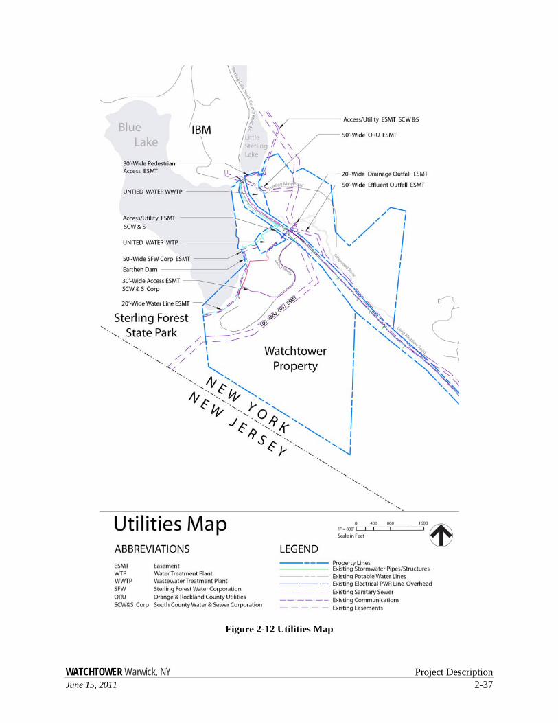
WATCHTOWER Warwick, NY Project Description June 15, 2011 2-37
Figure 2-12 Utilities Map

WATCHTOWER Warwick, NY Project Description June 15, 2011 2-39
Indoor and outdoor recreation spaces will be provided. Outdoor recreation is anticipated to include two tennis courts, two volleyball courts, a basketball court, and picnic tables. Indoor recreation will include a small swimming pool, basketball and racquetball courts, aerobic exercise, and game rooms. The swimming pool will be filled from domestic water connections located in the pool area. Chemicals used to maintain proper water quality in the pool include sodium hypochlorite for disinfection, and muriatic acid and sodium bicarbonate for pH balance. These chemicals will be stored in a separate room, away from the pool, within containment areas. Libraries will also be provided for the residents.
The footprint of the development has been kept to the smallest area practical to allow for the largest amount of open space. The approximate 50 acres in lots #2.22 (13.2 acres) and #2.3 (36.9 acres) northeast of Long Meadow Road and approximately 158 acres of land southwest of Long Meadow Road will be left undeveloped, other than unpaved walking trails to be used by residents for exercise, prayer, and meditation trails.
A total of 870 covered parking spaces will be provided for fleet, personal vehicles of the residents, and visitor parking. A total of 150 surface parking places will be provided in addition to parking for up to 13 buses. All of the covered parking will be in multi-story (mostly below street-level) garages to minimize footprint and runoff.
D. Project Purpose, Need, and Benefits
Objective of the Project Sponsor
As stated in its charter, the Project Sponsor’s purposes include to: “…support the efforts of Jehovah’s Witnesses to preach and teach the gospel of God’s Kingdom under Christ Jesus as a witness to the name, Word, and supremacy of Almighty God, JEHOVAH (Matthew 24: 14; 28: 19, 20; Psalm 83: 18; Isaiah 43: 10- 12); print, record by any means and in any medium, and otherwise produce, and distribute Bibles in any medium; disseminate Bible truths in various languages; write, record by any means and in any medium, and otherwise create, publish, and distribute literature in various languages containing information and comment explaining Bible truths and prophecy concerning the establishment of Jehovah’s Kingdom under Christ Jesus (2 Timothy 3:16, 17); write, record by any means and in any medium, and otherwise create, publish, and distribute music, art, and other intellectual property of a religious or educational nature in any medium; instruct and educate men, women, and children about the Bible and incidental scientific, historical, and literary subjects and to own and/or operate schools to advance such purpose; improve men, women, and children intellectually and morally by education based on Christian principles and to own and/or operate schools to advance such purpose; establish and operate private Bible schools, and ancillary facilities to house and care for the students at such schools, and classes for instructing men and women about the Bible, Bible literature, and Bible history; arrange for and hold assemblies for religious worship (Leviticus 23); maintain one or more religious orders of special ministers of Jehovah’s Witnesses (2 Kings 2:3, 5; 6:1).”
To accomplish these purposes, the personnel serving at the Brooklyn Facilities plan, research, and create the content of Jehovah’s Witnesses’ religious print, audio, and video publications and their educational programs, including those for schools for missionaries, special ministers, and religious administrators and for meetings and assemblies for public religious worship. Personnel serving there also oversee worldwide functions, including financial services and computer software creation and technical support, and some activities specific to the United States.
The worldwide activities of Jehovah’s Witnesses are overseen by the Governing Body, which has established over 100 branch offices of Jehovah’s Witnesses throughout the world. Worldwide, the number of active Jehovah’s Witnesses has grown from over 4,000,000 in 1990 to about 7,500,000 today, living in
WATCHTOWER Warwick, NY 2-40 June 15, 2011
236 lands. The number of those attending meetings of Jehovah’s Witnesses in their local congregations has grown from about 9.9 million in 1990 to over 18 million in 2010.
The world headquarters of Jehovah’s Witnesses oversees a worldwide religious organization that is well-known for its distribution of Bibles and Bible-based literature and providing free Bible education to all who wish to understand the Bible better. Over 165 million copies of all editions of the New World Translation have been printed in over 80 languages, with translation currently underway in more than 30 additional languages. Distribution of the bi-monthly magazine The Watchtower has steadily increased to its current average printing of over 42 million per issue in 185 languages, making it the most widely distributed magazine in the world. The monthly Awake! magazine, now published in 83 languages, is a general-interest magazine with a religious slant. The average printing of Awake! has increased from about 15 million in 1990 to over 39 million in 2010. Additionally, Jehovah’s Witnesses have produced 22 documentary videos on a variety of historical and Biblical topics in 71 languages and have prepared about 100 different American Sign Language programs in DVD format with a distribution of 527,555 copies a year.
The increased membership among Jehovah’s Witnesses and a concomitant increase in printing requirements have necessitated expansion and/or upgrading of the Project Sponsor’s facilities in the United States and those at other branches of Jehovah’s Witnesses in numerous locations around the world. Several growth factors are responsible for the rate at which these needs arise. They include: (1) as a result of world political changes and globalization, many countries of the world have opened up to Christianity in general and to Jehovah’s Witnesses in particular; (2) the worldwide growth in the number of Jehovah’s Witnesses and those associating with them; and (3) the increase in the worldwide demand for Bibles and Bible-related literature printed and published by Jehovah’s Witnesses.
These same factors have created a need to increase the size of the staff serving the world headquarters and some of its supporting departments. That need and the desire to withdraw from the sprawling Brooklyn Facilities and consolidate operations to a rural, contemplative facility that is compact and operationally efficient provide the catalyst for, and are the goals that the Project Sponsor intends to achieve by the proposed project.
Public Purposes: Meeting the Objectives of the Town of Warwick Comprehensive Plan
The proposed action will satisfy a number of public objectives as expressed in the Town of Warwick Comprehensive Plan. The adopted Comprehensive Plan makes the following comments related to this property and planning in general. Relevant quotations from the Comprehensive Plan are followed by comments on how the proposal relates to those quotations.
• Regional Planning Efforts (referring to the 2003 Orange County Comprehensive Plan): “The growth areas are general areas of preference for future development to maximize efficiency of infrastructure and services and minimize losses of open space. . . . In the County Plan . . . Urban development is shown . . . to a more limited extent in Sterling Forest around Sterling Lake and Sterling Forest Lake.” —Section 1.2, page 4, paragraphs 2 and 3.
The proposal concentrates development in an identified growth area from the Orange County Plan. As stated in the Town of Warwick, NY, 2008 Comprehensive Plan, the County Plan is only advisory. Nevertheless, focusing future development to existing villages, hamlets, and areas with existing infrastructure is a widely applied principal in the Town Plan, and is consistent with smart growth practice.
• Goals of the Community: “Protection of Warwick’s rural quality and its natural environment continue to clearly stand out as the major goals for the residents of Warwick.” —Section 1.4, page 10, paragraph 2.
Project Description June 15, 2011 2-41
The proposed project reflects this goal in redeveloping an area already developed while preserving the great majority of the approximately 250 acres in its natural state.
• Privately Operated Utilities: “Sterling Forest, east of Greenwood Lake, has centralized water and sewer services in the Town of Warwick at three locations. These facilities are capable of being expanded to provide for future planned development along County Road 84 (CR-84) in the Sterling Forest area. Touro College has been proposed for the former International Nickel site in the Town and it is possible that some additional commercial development will occur in this area by Sterling Forest or others.” —Section 2.9, page 55, paragraph 3.
The proposed project development will tap into already existing, but underutilized, water and sewer utilities.
• Agriculture, (C) Conservation Easements: “The Town has put into place a mechanism for receiving development rights and conservation easements from farmers and other property owners who would like to donate these rights to the public…. Warwick should consider expansion of this mechanism to receive conservation easement on other environmentally sensitive lands as well.”—Section 3.2, page 61, paragraph 1.
While the proposed project is not an agricultural use, the Town’s policy of receiving conservation easements on environmentally sensitive lands can be achieved. Specifically, the proposed project is seeking to heavily cluster disturbance on approximately 45 of 253 acres. The Project Sponsor will seek to ensure conservation of preserved lands and will explore the potential for furthering the Town’s goals while meeting its own preservation objectives.
• Residential Development, Community Objective: “Encourage a mixed-use pattern of development where appropriate, in and around the hamlets and adjacent to the Villages.”—Section 3.3, page 66, “Community Goals” textbox, bullet 4.
The proposed project is not located adjacent to a village or hamlet located in the Town of Warwick, although it is located adjacent to the Eagle Valley area of the Town of Tuxedo. Nevertheless, many of the benefits associated with mixed-use development will be achieved by the proposed action, specifically the significant reduction in automobile dependence, since residents will work and share meals communally, and recreational facilities will be available on site.
• Site Entrance and Parking (C): “Paved parking areas should be decentralized and placed as far from public view as possible…Additional limitation should…reduce the number of entrances onto major roads, as well as eliminate the possibility of continuous paved access.”—Section 3.4, page 85, paragraph 3.
The proposal provides for all resident parking to be located in below-ground parking garage to minimize surface cover. Main-site ingress and egress will be achieved via a boulevard leading from and to a single-site entrance. To the extent possible, the existing main access road will be utilized in order to minimize disturbance to the landscape. The project will similarly take advantage of existing utilities.
• Commercial and Industrial Development, (D) Other Compatible Businesses: “Other kinds of economic activity, which are compatible with public desires for a quiet residential community, include institutions of higher learning, enterprises related to the visual and performing arts, tourism, and home occupations which do not depend on daily high volume customer traffic and do not have other negative effects on the residential neighbors…. Finally, the physical attractiveness of the area should be recognized as an economic resource supporting restaurants, recreational sites and tourism.” —Section 3.4, page 85, paragraph 5.
WATCHTOWER Warwick, NY 2-42 June 15, 2011
The proposed project will have a positive economic benefit to the community due the expenditure of funds to maintain and operate the facility and due to the tourism associated with the development. It will not generate a high volume of traffic and will have a minimal effect on the surrounding area compared to other potential uses. The world headquarters is currently a very popular tourist destination for Jehovah’s Witnesses throughout the world. Currently, when touring the Brooklyn Facilities, visitors typically visit other popular destinations in New York City. With the proposed project these visitors will be brought to Warwick and will seek tourist destinations, lodging, and restaurants in the area.
• Open Space and Recreation, Community Objective: “Support preservation of open space, especially in environmentally sensitive areas.” —Section 3.5, page 86, “Community Goals” textbox, bullet 2.
The proposed project contains sensitive lands including wetlands, steep slopes, and potentially important habitat areas. The project will be clustered on 18 percent of the total site, disturbing only 45 of 253 total acres—almost half of which was already disturbed for a previous development.
• Public Facilities, (B) Water and Sewer Service: “The Comprehensive Plan encourages areas with high development density, on the border of Villages or other areas with community water and sewer, to connect to these existing public services if capacity is available.” —Section 3.7, page 95, paragraph 2.
The proposal is similar to the referenced previously planned development by a non-profit entity and will similarly take advantage of existing, under-utilized utilities. It is noted that the local water utility is not private but is operated by United Water, a public utility. Adequate water and sewer capacity exist at the site.
• Controlling the Intensity of Office and Industrial Use: “Additional limitations should restrict curb cut width and spacing, reduce the number of entrances onto major roads.”—Section 3.4.C, page 85, paragraph 1.
The proposed layout has just one entrance for daily use, including visitors and deliveries. A second road—required by fire code—will be locked and used for emergencies only.
• Architectural design and layout suitable to its environs: “The negative aesthetic and traffic impacts of office and light industrial structures can be reduced by design requirements related to architecture, parking, and access….Paved parking areas should be decentralized and placed as far from public view as possible.”—Section 3.4.C, page 85, paragraph 2.
The architectural design theme of the project was developed in consultation with Perkins Eastman of New York with interim reviews and input by members of the Warwick Planning Board. In order to keep paved parking areas “as far from public view as possible” the Project Sponsor plans to construct underground parking garages which will meet the parking requirements. These garages will also greatly reduce the non-pervious surface parking footprint, thereby reducing stormwater run-off.
• Public Facilities, (E) Health and Safety: “The Comprehensive Plan strongly supports the inspection of all bridges and dams within the Town, including those under the jurisdiction of Orange County and the State, for their safety and structural integrity on a regular basis.”—Section 3.7, page 97, paragraph 1.
The Project Sponsor, as a responsible property manager, will meet or exceed the local and NY State requirements for inspection and maintenance of the dam.
• Environmental Protection, (B) Sensitive Environments: “Steep slopes, significant habitats, wetlands and other water bodies are environmentally sensitive areas that should be protected…perhaps through
Project Description June 15, 2011 2-43
the Town’s Ridgeline Overlay District regulations….Significant habitats have been identified through a comprehensive examination of such areas by the Metropolitan Conservation Alliance, which resulted in the Southern Wallkill Biodiversity Plan (SWBP).”—Section 3.8, page 99, paragraphs 4, 5.
The proposed project lies almost entirely outside the boundaries of both the Southern Wallkill Biodiversity Plan (SWBP) and the 700-foot Ridgeline Overlay District. (See Figure 2-13 Southern Wallkill Biodiversity Plan (SWBP) and 700-foot Ridgeline Overlay District.) Even so, the proposed action acknowledges the importance of maintaining a diversity of habitats and satisfies a number of objectives outlined in the SWBP. By limiting the proposed development to just 18 percent of the 253 acres, a substantial amount of undisturbed wildlife habitat is retained.
• Environmental Protection, (C) Vegetation: “Vegetation retards water runoff, thus helping to preserve the water table and to prevent flooding. It stabilizes the slopes and prevents soil erosion and excessive siltation of the stream beds. It also reduces air and noise pollution and offers a beautiful scenic resource that is so important to Warwick. Future development should be carefully planned and controlled to avoid the destruction of this valuable natural resource.”—Section 3.8, page 100, paragraph 3.
The proposal will maximize the retention of existing vegetation. As a result, the benefits outlined will be achieved.
• Environmental Protection, (H) Energy: “Since energy usage has become a critical concern in the Town and globally, the Town should consider substantially strengthening the Building Code with regards to energy use in both residential and commercial properties. The Town should consider following the leas of the Orange County Planning Department regarding the US Green Building Council Program or that of the LEED (Leadership in Energy and Environmental Design.)”—Section 3.8, page 102, paragraph 2, 3.8.
The proposal will include energy reduction strategy as part of its design. The Project Sponsor is registered with the Green Building Initiative (GBI) which has established a sustainability program similar to the US Green Building Council (USGBC). GBI promotes a rating system similar to the LEED system that awards from one-to-four Green Globes™ based on the points obtained in the design and construction of projects. The Green Globes™ program also incorporates a third-party verification of actual project accomplishments as compared to proposed initiatives. This project will strive for a rating of three Green Globes™, which is similar to a LEED Gold rating.

WATCHTOWER Warwick, NY Project Description June 15, 2011 2-45
Figure 2-13 Southern Wallkill Biodiversity Plan (SWBP) and 700-foot Ridgeline Overlay District

WATCHTOWER Warwick, NY Project Description June 15, 2011 2-47
E. Construction and Operations
Construction
Construction is proposed to begin upon completion of the permit process in 2012 and is anticipated to continue for approximately four years.
The proposed project will require the disturbance of approximately 45 acres. During construction, unstabilized disturbed soils will not exceed ten acres at any given time. The proposed project will be divided into a pre-construction phase and 13 construction phases and will proceed in compliance with the New York State (NYS) Department of Environmental Conservation (DEC) limits.
Sequence
See the Stormwater Pollution Prevention Plan (SWPPP) in Appendix M for construction sequencing as well as phasing maps for the proposed project. The pre-construction and 13 construction phases will generally follow the sequence outlined in Appendix M, Section 2, and as summarized in Table 2-4:
Table 2-4 Construction Phasing
Phase and Area of
Disturbance Construction Activity Phase 1 – 7.5 Acres
Construction road access, Vehicle Maintenance Building, Utility Installation
Phase 2 – 10.0 Acres
Staging Areas
Phase 3 – 5.7 Acres
Temporary Concrete Batch Plant
Phase 4 – 9.0 Acres
Maintenance Building
Phase 5 – 8.0 Acres
Temporary Housing, C Residence, Utility Install
Phase 6 – 5.7 Acres
C Residence, D Residence, Maintenance Building
Phase 7 – 5.3 Acres
D Residence, Maintenance Building, Main Entrance
Phase 8 – 9.1 Acres
Maintenance Building, Visitor Parking Structure
Phase 9 – 8.0 Acres
Visitor Parking Structure, Administration Offices/Services Building, Residence A
Phase 10 – 4.4 Acres
Services Building, Residence A
Phase 11 – 5.5 Acres
Administration Offices/Services Building, Residence B
Phase 12 – 7.1 Acres
Administration Offices/Services Building, Residence B
Phase 13 – 2.1 Acres
Recreation Area
WATCHTOWER Warwick, NY 2-48 June 15, 2011
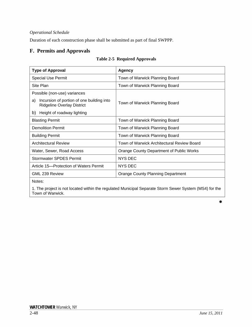
Operational Schedule
Duration of each construction phase shall be submitted as part of final SWPPP.
F. Permits and Approvals Table 2-5 Required Approvals
Type of Approval Agency
Special Use Permit Town of Warwick Planning Board
Site Plan Town of Warwick Planning Board
Possible (non-use) variances
a) Incursion of portion of one building into Ridgeline Overlay District
b) Height of roadway lighting
Town of Warwick Planning Board
Blasting Permit Town of Warwick Planning Board
Demolition Permit Town of Warwick Planning Board
Building Permit Town of Warwick Planning Board
Architectural Review Town of Warwick Architectural Review Board
Water, Sewer, Road Access Orange County Department of Public Works
Stormwater SPDES Permit NYS DEC
Article 15—Protection of Waters Permit NYS DEC
GML 239 Review Orange County Planning Department
Notes:
1. The project is not located within the regulated Municipal Separate Storm Sewer System (MS4) for the Town of Warwick.