Embed Size (px)
Citation preview
27N.F. Bicho et al. (eds.), Trekking the Shore: Changing Coastlines and the Antiquity of Coastal Settlement, Interdisciplinary Contributions to Archaeology,DOI 10.1007/978-1-4419-8219-3_2, © Springer Science+Business Media, LLC 2011
Introduction
Awareness of and interest in the role that coastlines and coastal adaptations played in the development and dispersal of anatomically modern humans have grown over the last few decades. Scattered evidence for marine exploitation between 125,000 and 12,000 cal BP has been identified in Africa (Henshilwood et al. 2001; Singer and Wymer 1982; Walter et al. 2000), Eurasia (Stiner 1999; Straus et al. 1993), and North America (Erlandson et al. 1996). Yet, robust archaeological evidence for coastal activities accrues worldwide predominantly after 10,000 cal BP (Des Lauriers 2005; Dixon et al. 1997; Dunbar 1997; Erlandson 2002; Glassow et al. 2008; Jacobsen 1973; Keefer et al. 1998; Sandweiss et al. 1998; Stothert 1985). This relatively late appearance of clear-cut evidence for early coastal exploitation has been used to propose that early humans had little interest in coasts until stressed to seek less productive resources (Yesner 1987). Conversely, many researchers argue that the paucity of identified coastal sites dating to earlier times is more likely a result of our inability to locate these sites, rather than a lack of interest in coasts and coastal resources by early humans (Dixon 2001; Erlandson 2001; Kraft et al. 1983). Numerous Pleistocene age coastlines were deeply submerged during the postglacial period of eustatic sea level rise; and in areas such as the Northwest Coast of North America, isotastic rebound outpaced sea level rise, leaving Pleistocene coastal landscapes miles inland from current shorelines. These factors conspire to make locating Pleistocene landscapes difficult, and identifying preserved sites on those landscapes, a challenge.
While factors affecting visibility of coastal sites have a global impact on archae-ological research, the submersion of North American coastlines due to eustatic sea level rise presents a particularly significant obstacle in clarifying New World archaeological migration models and chronologies. Although the exact manner and
A.E. Gusick (*) Department of Anthropology, University of California, Santa Barbara, CA 93106-3210, USA e-mail: [email protected]
Chapter 2Prehistoric Archaeology Underwater: A Nascent Subdiscipline Critical to Understanding Early Coastal Occupations and Migration Routes
Amy E. Gusick and Michael K. Faught
28 A.E. Gusick and M.K. Faught
timing of an initial human migration into the New World remain in discussion (Adovasio et al. 1978; Barton et al. 2004; Bradley and Stanford 2004; Faught 2008; Gruhn 1988), a Pleistocene Pacific coastal migration has been hypothesized to have occurred before 13,000 cal BP, when sea levels were lower than today (Dixon 2001; Faught 2008; Fladmark 1979; Mandryk et al. 2001; Waters and Stafford 2007). Accurate modeling of the initial or any later coastal migration and the full range of settlement patterns employed by early peoples are complicated by the submersion of coastal habitats and the archaeological evidence they contain.
Today, the increased need to identify coastal adaptations and other early sites in submerged contexts in the New World has led researchers to obtain additional data from submerged continental shelf settings. Recent advancements in oceanography (e.g., sound underwater imagery and accurate Differential Global Positioning System (DGPS) mapping, to be discussed) and developments in industry (e.g., precision dredging and resource mining methods) combine to provide researchers with increasing abilities to explore submerged prehistoric archaeological sites in marine environments. While the search for these submerged prehistoric sites is a nascent endeavor, marine submerged prehistoric archaeology can offer a method to investigate more fully coastal environments and their importance to past human development. Current researchers focus mostly on paleolandscape reconstruction and location of paleoshorelines surrounding the western hemisphere that may offer more evidence of New World Pleistocene coastal migration and early habitation sites (Adovasio and Hemmings 2009; Evans et al. 2007; Fedje and Christensen 1999; Fedje and Josenhans 1999; Faught 2002, 2004; Gusick and Davis 2010a, 2010b; Josenhans et al. 1995; Pearson et al. 1986).
Our purpose in this chapter is to organize our experiences, and those of others, to expose some principles and ideas concerning how best to conduct prehistoric archaeology underwater. These principles and ideas are both intuitive and practiced and integrate culture histories, sea levels, paleolandscape, and predictive modeling methods, as well as knowledge of the kinds of equipment that can be integral to identifying archaeological evidence in a marine context. Our goal is to move sub-merged prehistoric archaeology from a nascent discipline within archaeology to a viable research method considered for most studies conducted in coastal areas.
Background to Submerged Prehistoric Underwater Archaeology
Underwater archaeology gained a place within academic archaeology in the 1960s with the underwater excavation, mapping, analysis, and publication of several Bronze Age shipwrecks in the Mediterranean (Bass 1966, 1967; Throckmorton 1970). Bass and his colleagues at the time (Dumas, du Plat, Frost, and Throckmorton) showed that mapping and excavations underwater could be controlled, that fragmentary ship remains were still useful for study, and that the analysis of ship building techniques and shipwreck trade assemblages could be valuable data for historians, classical archaeologists, and anthropologists (Gould 2000; Muckelroy 1978, 1980).
292 Prehistoric Archaeology Underwater
The underwater archaeology of submerged prehistoric sites is following a path somewhat similar to that of shipwreck archaeology; however, interest in developing specific methods for the underwater archaeology of prehistoric sites has begun to grow within the last few decades. Submerged freshwater prehistoric sites have been known since the nineteenth century in various lakes and rivers; yet, theory building, research, and publication necessary to develop predictive models and accumulate examples for open ocean submerged prehistoric sites did not start to accrue until the 1980s (Bailey and Parkington 1988; Gifford 1983; Hoyt et al. 1990; Masters and Flemming 1983; Stright 1990).
Prehistoric sites submerged in marine environments represent a special genre of underwater archaeological sites, with increasing numbers of examples of published research projects and a growing list of sites found by focused research. Recent stud-ies into submerged terrains have found that excavations and mapping can be accom-plished, that reworked sites remain valuable resources, and that archaeologists and anthropologists can use data collected from marine submerged sites to expand their knowledge of past settlement ranges and migration paths (Faught 2004; Master and Flemming 1983).
Worldwide, there are several important examples of marine submerged Early and Middle Holocene age archaeological sites studied by archaeologists (Fischer 1995; Flemming 1983). The best examples are found in low energy brackish water sediments containing Mesolithic age artifacts (8,000–5,000 cal BP) submerged by Holocene sea level fluctuation in Denmark and Germany (Andersen 1987). In the Mediterranean, off the coastline of Israel, Middle Holocene age stone structures and refuse deposits, including an early olive processing facility, have been exca-vated and studied (Galili and Weinstein-Evron 1985). Earlier sites are also known from marine contexts, but they are more rare. Petroleum geologists discovered Mousterian artifacts in 17 m of water north of Cherbourg, France (Scuvée and Verague 1988). This site, Fermanville, has produced 2,500 pieces of chipped stone (including tools and debitage) indicating Middle Paleolithic (Mousterian of Acheulean Tradition) artifacts in possible terrestrial sediments. Other early marine submerged site representatives include hand axes indicating Lower Paleolithic age reported from Table Bay, South Africa (Werz and Flemming 2001).
Turning to projects in North America, there are several examples of marine inun-dated prehistoric archaeology along the Pacific and Atlantic coasts and in the Gulfs of Mexico and California. Pacific Coast projects include the use of marine remote sensing tools for paleolandscape reconstruction (Josenhans et al. 1995, 1997), testing with grab samples and coring in Hecate Strait (Fedje and Josenhans 1999) and in the Gulf of California (Gusick and Davis 2010a, 2010b), subbottom profiling and water dredge excavations in Middle Holocene age deposits at Montague Harbour in British Columbia (Easton and Moore 1991), and geoarchaeological studies focused on predictive model-ing off of the Oregon coast (Davis et al. 2009) and the Northern Channel Islands (Garrison 2000). Additionally, over 2,000 mortars and other ground stone artifacts have been found offshore in Southern California since 1915 (Masters 1983, 1996).
Research in the Gulf of Mexico and off the Atlantic coast has focused on sub-bottom profiling and side scan sonar to reconstruct channel configurations and to
30 A.E. Gusick and M.K. Faught
identify anomalies for further testing; and coring or excavating to test sediment packages in order to locate paleo- and archaic-age sites (inter alia Adovasio and Hemmings 2009; Blanton and Margolin 1994; Evans et al. 2007; Faught 2002, 2004; Fillon 2006; Garrison 2006; Merwin 2006). The methods used in marine contexts have also been successfully applied to underwater research in the Great Lakes (O’Shea and Meadows 2009) and in the Damariscotta River (Leach and Belknap 2007).
The methodological approaches used by North American researchers revolve around geoarchaeologically based reconstructions of evolving Late Pleistocene and Early Holocene coastal paleolandscapes and paleoenvironments. By effectively combining environmental reconstructions with bathymetric surveys and local settle-ment patterns, these researchers have delineated survey areas with high archaeo-logical potential. As will be discussed below, many of these projects show that mapping and reconstructing the locations of paleodrainage and paleolandscape features, and seeking out preserved sediment beds, are effective tools in predicting where to look for archaeological sites in local settings.
Principles and Methods
In the 1960s, oceanographers J.O. Emery and M. Edwards of the Woods Hole Oceanographic Institute realized the great potential for marine inundated prehistoric archaeological research along the Eastern seaboard, and they theorized about the kinds of data that would be needed to find submerged sites (Emery and Edwards 1966). They proposed four guidelines that are still useful today, (1) determine the local sea level history, (2) assess site preservation potentials, (3) assess relevant cultural time periods of local human occupation, and (4) know the functional range of sites which might be expected (Stright 1990, p. 439).
Recent research has expanded on these principles and added various technologies that allow for more refined predictive modeling of archaeological site locations. Advancements have also been made with the excavation of prehistoric sites in a marine inundated context. While some methods are borrowed from shipwreck archaeology, many are unique to marine inundated prehistoric archaeology, and certainly resemble modified versions of terrestrial archaeological methods. Although there is not yet a textbook on field methods in marine inundated prehistoric archae-ology, the methods that will be described below have proven effective in locating submerged prehistoric archaeological material in various marine contexts throughout North America.
Paleolandscapes
Reconstructing the paleolandscape underwater is integral for identifying locales with high archaeological potential. Determining morphological characteristics such as river channels, bedrock depressions, or complex topographic features may
312 Prehistoric Archaeology Underwater
indicate biologically productive areas such as riparian environments, estuaries, rocky headlands, or rocky intertidal habitats. Navigation charts can be effective for identifying general areas for survey in deeper water. Faught (2002) digitized the recorded depth points from a navigation chart to reconstruct the PaleoAucilla chan-nel system, which was then refined with subbottom profiler data. For their work on the Florida Middle Grounds in the Gulf of Mexico, Adovasio and Hemmings (2009) focused their survey efforts on relict embayments and possible paleoshore-lines in the 40–120 m depth range, which they located by using a sea depth chart and knowledge of previous research conducted in the region (Faught 2002).
Though navigation charts may work for identifying larger formations or general survey areas, identifying smaller landforms and features, and specific potential locations for sites, demands more precise and abundant data. Areas with a slight increase or decrease in relief, which may not be indicated on a navigation chart, can signal the presence of smaller landscape features that may have been central to prehistoric economic and habitation activity. Features such as steep slopes, smaller rock outcrops, or shell middens are usually integral to the economy of coastal hunter-gatherer groups and may be too small to identify without high-resolution bathymetry.
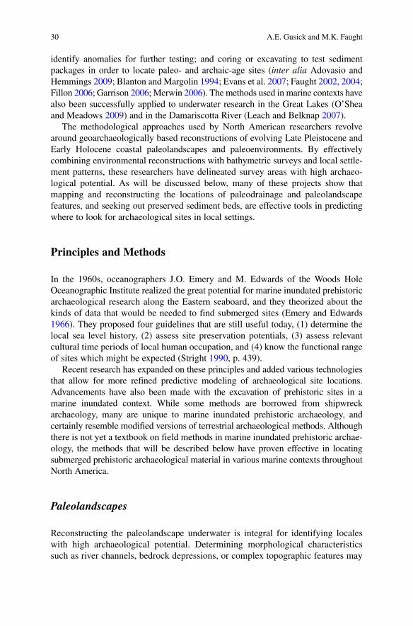
A great example of finding and sampling potential paleolandscapes comes from British Columbia. Building on the knowledge that favorable Late Pleistocene age terrestrial environmental contexts remained under the immediate waters of Haida Gwaii, British Columbia, Fedje and colleagues have employed swath bathymetric data (very high resolution bathymetric data) to model the drowned landscape in Hecate Strait and then incorporated high-resolution subbottom profiling and side scan sonar surveys to locate submerged terrestrial landforms for core sampling (Fedje and Josenhans 2000; Josenhans et al. 1995, 1997) (Fig. 2.1). This approach has also proven effective along Florida’s Gulf coast, where numerous researchers rely on side scan sonar and subbottom profiler images to select survey locations that appear analogous to the settings of local terrestrial prehistoric sites (Adovasio and Hemmings 2009; Faught 2002, 2004) or to select specific features for coring (Evans et al. 2007).
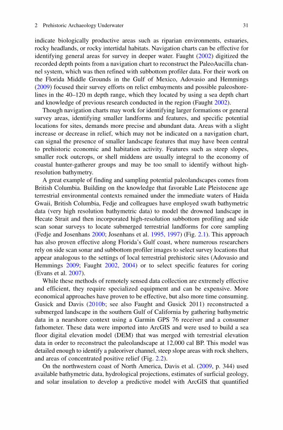
While these methods of remotely sensed data collection are extremely effective and efficient, they require specialized equipment and can be expensive. More economical approaches have proven to be effective, but also more time consuming. Gusick and Davis (2010b; see also Faught and Gusick 2011) reconstructed a submerged landscape in the southern Gulf of California by gathering bathymetric data in a nearshore context using a Garmin GPS 76 receiver and a consumer fathometer. These data were imported into ArcGIS and were used to build a sea floor digital elevation model (DEM) that was merged with terrestrial elevation data in order to reconstruct the paleolandscape at 12,000 cal BP. This model was detailed enough to identify a paleoriver channel, steep slope areas with rock shelters, and areas of concentrated positive relief (Fig. 2.2).
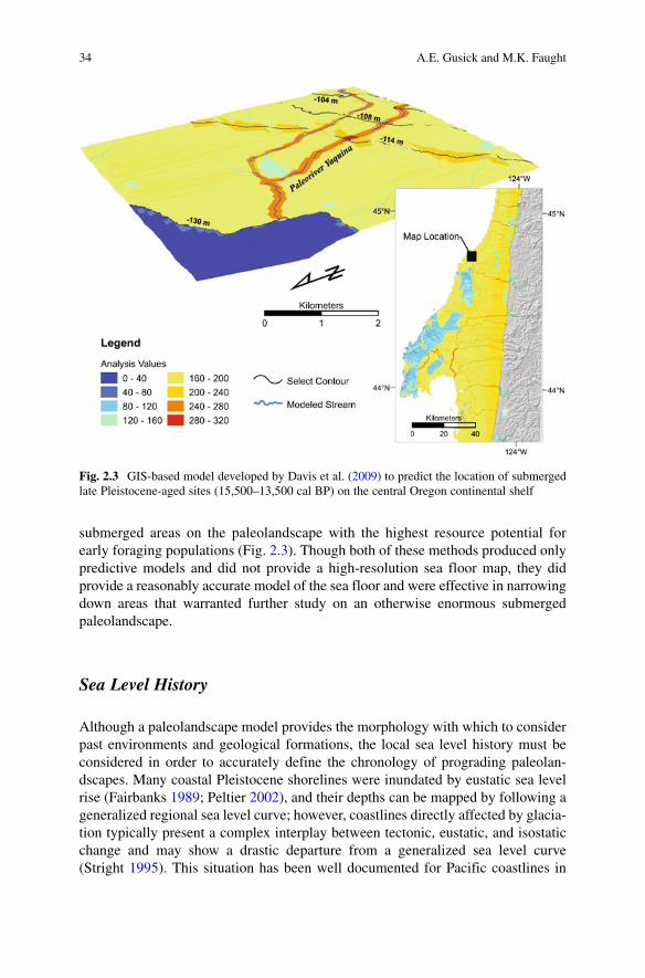
On the northwestern coast of North America, Davis et al. (2009, p. 344) used available bathymetric data, hydrological projections, estimates of surficial geology, and solar insulation to develop a predictive model with ArcGIS that quantified
32 A.E. Gusick and M.K. Faught
Fig
. 2.
1 L
eft
imag
e sh
ows
larg
e ar
ea o
f gl
acia
lly o
verd
eepe
ned
basi
n w
ith e
nd m
orai
ne t
o ea
st a
nd r
iver
del
ta(s
) to
sou
th (
Hei
ner
Jose
nhan
s, G
eolo
gica
l Su
rvey
of
Can
ada)
. Rig
ht im
age
is d
etai
l (50
m c
onto
ur)
of a
rea
in w
hite
box
sho
win
g m
odel
of
Hux
ley
Isla
nd e
nvir
ons
at c
a. 1
1,50
0 B
P. T
he la
ndsc
apes
su
rrou
ndin
g an
d be
twee
n M
ores
by I
slan
d, H
uxle
y Is
land
, and
Bur
naby
Isl
and
up t
o Ju
an P
erez
Sou
nd w
ere
suba
eria
l du
ring
pre
hist
oric
tim
es. T
oday
, onl
y th
e th
ree
isla
nds
are
suba
eria
l lan
dmas
ses
(Dar
yl F
edje
and
Pat
rick
Bar
tier,
Park
s C
anad
a)
332 Prehistoric Archaeology Underwater
Fig
. 2.
2 Pa
leol
ands
cape
mod
el d
epic
ting
a se
ctio
n of
lan
dsca
pe i
n B
aja
Cal
ifor
nia
at 1
2,00
0 B
P. S
urve
y ar
eas
depi
cted
are
cur
rent
ly s
ubm
erge
d.
Eac
h ar
ea in
clud
es d
epth
bel
ow c
urre
nt s
ea le
vel a
nd th
e tim
e th
at a
SC
UB
A d
iver
wou
ld b
e ab
le to
rem
ain
at e
ach
dept
h.
34 A.E. Gusick and M.K. Faught
submerged areas on the paleolandscape with the highest resource potential for early foraging populations (Fig. 2.3). Though both of these methods produced only predictive models and did not provide a high-resolution sea floor map, they did provide a reasonably accurate model of the sea floor and were effective in narrowing down areas that warranted further study on an otherwise enormous submerged paleolandscape.
Sea Level History
Although a paleolandscape model provides the morphology with which to consider past environments and geological formations, the local sea level history must be considered in order to accurately define the chronology of prograding paleolan-dscapes. Many coastal Pleistocene shorelines were inundated by eustatic sea level rise (Fairbanks 1989; Peltier 2002), and their depths can be mapped by following a generalized regional sea level curve; however, coastlines directly affected by glacia-tion typically present a complex interplay between tectonic, eustatic, and isostatic change and may show a drastic departure from a generalized sea level curve (Stright 1995). This situation has been well documented for Pacific coastlines in
Fig. 2.3 GIS-based model developed by Davis et al. (2009) to predict the location of submerged late Pleistocene-aged sites (15,500–13,500 cal BP) on the central Oregon continental shelf
352 Prehistoric Archaeology Underwater
Haida Gwaii on the northern Northwest coast of North America. Much of this landscape was greatly affected by glaciation, resulting in “significant difference in the timing and limits of sea-level position” (Fedje and Christensen 1999, p. 637; Clague 1983; Josenhans et al. 1997). Additionally, McLaren et al. (2007, p. 2) have identified shorelines in Haida Gwaii that were “isostatically depressed as a result of glacial loading during the last glacial maximum, resulting in Late Pleistocene sea levels that were higher than today, leaving relict shorelines inland” rather than deeply submerged. This research illustrates the necessity of using local geologic history to determine if factors such as ice loading, uplift, or tectonic activity may have played a significant role in regional sea level history.
Culture Histories, Adaptation to Environments, and Behavioral Regularities
While paleolandscape models can provide researchers with means of identifying landforms that are considered integral to general prehistoric economy and habita-tion, knowledge of local cultural histories will elucidate population dynamics, chronologies and settlement patterns, adaptive behaviors, and diagnostic artifacts that are archaeologically sensitive in a regional context. Population dynamics refers to the abundance, or lack thereof, of sites of different time periods relevant to offshore settings, and the research on settlement patterns refers both to modeling missing resource or habitation zones, as well as adding to local understanding of the archaeological record.
Understanding local cultural systems and specific adaptations to both environ-mental and social pressures will provide insight into the types of material that can be expected to occur in preserved archaeological sites within various regions. Of course, one typical assumption regarding sites on a coastal landscape is that they will progressively show more faunal evidence of coastal adaptations the closer they are to the shoreline; however, not all sites located on submerged coastal land-scapes will necessarily present clear indications of marine exploitation. While many pre-8,000 cal BP Pacific coastal sites yield the remains of marine resources (Erlandson 1994; Erlandson and Colten 1991; Glassow 2006; Glassow et al. 2008; Kennett 2005; Rick et al. 2001, 2005), contemporaneous sites in the Southeast, both terrestrial and submerged, have only produced evidence of terrestrial subsistence (inter alia Clausen et al. 1979; Driskell 1996; Dunbar et al. 1988; Webb 2006). Therefore, marine inundated prehistoric archaeology demands that archaeologists be knowledgeable about the local or regional prehistory, thus enabling them to know what they are looking for; what they are finding; and where to integrate the findings into local prehistoric reconstructions, settlement patterns, and chronologies.
Current underwater research in North America is shaped around knowing local human behavioral patterns that can provide defined guidelines for identifying locales considered high-potential for submerged cultural remains in the context of
36 A.E. Gusick and M.K. Faught
local cultural behaviors. Settlement patterning in the Northeast suggests that prehistoric groups exploited and processed eastern oyster (Crassostrea virginica), leaving traces of this activity close to natural oyster bioherms. Current archaeological investigation in the Damariscotta River in Maine focuses on identifying and sampling relict oyster bioherms, which have been preserved in marine sediment, in an attempt to locate cultural shell middens (Leach and Daniel 2006). Another inventive use of local cultural knowledge, though not in a marine setting, is found in research conducted in the Great Lakes. O’Shea and Meadows (2009) have identi-fied potential caribou drive lanes (stone structures used for caribou hunting) that have been submerged beneath Lake Huron. These types of linear stone structures have previously been identified in a terrestrial setting and are associated with prehistoric and ethnographic caribou hunting. By framing their research around a local cultural activity that occurs on a specific type of landscape and leaves definite, identifiable evidence, they were able to narrow their search area and identify a unique submerged cultural site.
Preservation Potential and Processes
Even armed with an accurate paleolandscape model that presents features known to be important within the local culture history, the probability that archaeological remains may be preserved must be predicted and assessed. There are, of course, numerous factors in a marine context that can be detrimental to the preservation of submerged remains; however, there are contexts in which preservation potential can be considered favorable (Flemming 1983; Stright 1995). An ideal study area must exhibit a morphology that is not only biologically productive and attractive for habitation but also shows physical constraints that allow for preservation and acces-sibility (Fedje and Christensen 1999, p. 650). For instance, coastal caves and rock-shelters have proven to be ideal locations for early mobile hunter-gatherer occupation (Erlandson 1993; Erlandson et al. 1996; Dixon et al. 1997; Fujita and Poyatos de Paz 1998; Gruhn and Bryan 2002; Fedje et al. 2004) and these recesses may provide protection from wave and tidal action in a submerged environment (Inman 1983). Regions in which structural contexts result in shallow bays can limit the amount of site disturbance from tidal action or storm surges, and supplementary protection from wave energy is also found on the leeward side of coastal islands and within archipelagos (Flemming 1983, p. 138). Coastlines with gently sloping continental shelves, particularly in locales with reduced wave action, would have been quickly inundated during sea level rise, promoting rapid sedimentation and therefore protection of archaeological sites from environmental elements. In fact, the anaerobic environment that can exist in the seabed is favorable for preservation of organic material (Dean et al. 1995, p. 31; Muckelroy 1978, p. 52).
Underwater research efforts in North America reflect the importance of identify-ing areas with high preservation potential. The protected bays within the archipelagos along the northern Northwest Coast have been the focus of dedicated paleolandscape
372 Prehistoric Archaeology Underwater
modeling and archaeological sampling, resulting in the identification of submerged cultural material (Easton and Moore 1991; Fedje and Josenhans 2000; Fedje and Christensen 1999; Josenhans et al. 1995). Projects in the Gulfs of Mexico and California have benefited from the gently sloping bathymetry of the continental shelves in many areas of these regions and from the reduced wave energy typical of gulf contexts (Adovasio and Hemmings 2009; Evans et al. 2007; Faught and Gusick 2011; Gusick and Davis 2010b). Additionally, Faught’s (2002) work in the Gulf of Mexico relies, in part, on identifying submerged karst features, as these are known from local terrestrial settings to contain preserved archaeological evidence.
Even in regions with numerous conditions favorable for preservation, geologic, hydrologic, and oceanographic changes that have occurred over the past 15,000 years may have greatly affected the preservation of archaeological material. For instance, while the geomorphology of eastern Pacific coastal environments, with rocky shores and deep basins, provides enclaves and rockshelters that can act to protect archaeological remains, the formidable wave action in this area of the world can erode away sea cliffs and cut terraces (Inman 1983), possibly destroying evidence of prehistoric occupation. In areas with reduced wave action such as the Gulfs of Mexico and California, site preservation may be more probable than those areas exposed to the open ocean, but the frequent hurricanes that occur in these regions may destroy or alter the location of submerged remains.
An additional consideration is sedimentation rates. Although sedimentation can aid in preservation, the amount of sediment that accumulated during marine trans-gression can be massive, resulting in deeply buried terrestrial surfaces. Punke and Davis (2006, p. 336) have identified Pleistocene landforms in the Pacific Northwest that are buried beneath the 28 m of fine- to course-grained sediment that has been deposited over the last 10,000 years. The depth of sediment covering a terrestrial surface can be difficult to determine without obtaining sediment core samples; however, images generated from a subbottom profiler can provide an indication of sediment cover. Use of this remote sensing equipment will be discussed below.
Survey Methods
The processes of narrowing down targeted features to those most favorable for investigation considering the paleolandscape, paleoenvironment, sea level history, cultural history, and preservation potential aid in determining general areas con-sidered to have high-potential for preserved archaeological remains. This informa-tion is important when developing an effective underwater survey design, as location and depth of targets will determine the type of survey necessary for effica-cious investigation. Additionally, marine inundated prehistoric archaeology can be time-consuming and costly; therefore, developing a survey design focusing first on those areas considered to have high-potential for archaeological remains can greatly increase productivity and maximize time and expenses.
38 A.E. Gusick and M.K. Faught
Remote Sensing Survey: Sound Underwater Imagery
Searching submerged landscapes for prehistoric sites and artifacts is more than a challenge. Areas to survey are extremely large; and discovery of small objects (i.e., stone, bone, or wood artifacts) is akin to finding little needles in gigantic haystacks. Few sites will be exposed for surface collection, although they do exist (Faught 2002, 2004). Consequently, it is timely that digital mapping of large areas of the sea floor bottom, and remote probing of the sediment beds below, is currently possible because of technological advancements in remotely sensed sound under-water imagery and precise, integrated DGPS locational controls.
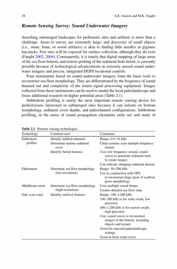
Four instruments based on sound underwater imagery form the basic tools to reconstruct sea floor morphology. They are differentiated by the frequency of sound beamed out and complexity of the return signal processing equipment. Images collected from these instruments can be used to model the local paleolandscape and focus additional research on higher potential areas (Table 2.1).
Subbottom profiling is surely the most important remote sensing device for prehistorians interested in submerged sites because it can inform on bottom morphology, sediment cover depths, and paleochannel configurations. Subbottom profiling, in the sense of sound propagation (dynamite early on) and study of
Table 2.1 Remote sensing technologies
Technology Common uses Comments
Subbottom profiler
Identify infilled-channels Range: 0.9–34 kHzDetermine marine sediment
coverChirp systems scan multiple frequency
returnsIdentify buried features Uses low frequency seismic sound
waves to penetrate sediment beds to create images
Can indicate changing sediment densityFathometer Determine sea floor morphology
(low-resolution)Range: 50–200 kHzUse in conjunction with GPS
to reconstruct large areas of seafloor gross morphology
Multibeam sonar Determine sea floor morphology (high-resolution)
Uses multiple sound beamsCreates detailed sea floor map
Side scan sonar Identify surficial features Range: 100–1,200 kHz100–300 kHz is for wide swath, low
precision400–1,200 kHz is for narrow swath,
high precisionUses sound waves to reconstruct
images of the bottom, including objects and texture
Good for exposed paleolandscape settings
Good in fresh water rivers
392 Prehistoric Archaeology Underwater
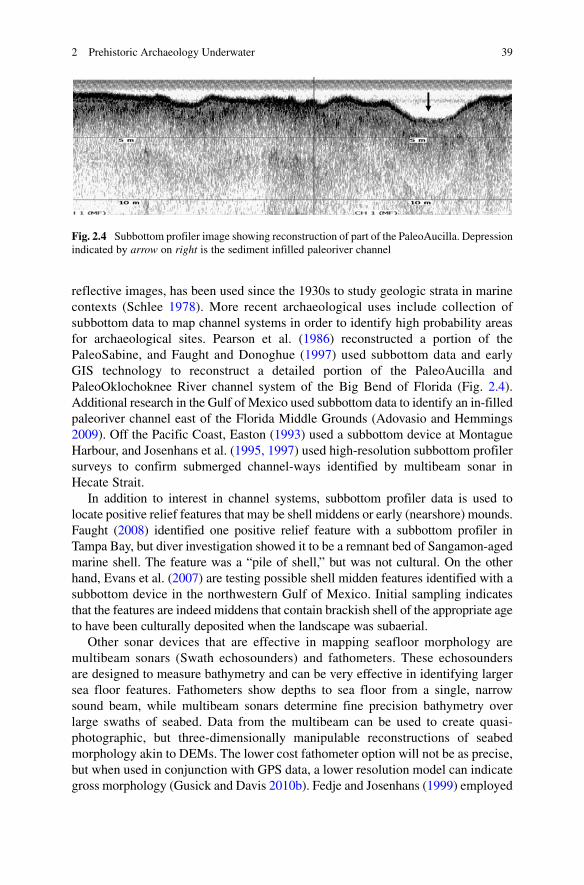
reflective images, has been used since the 1930s to study geologic strata in marine contexts (Schlee 1978). More recent archaeological uses include collection of subbottom data to map channel systems in order to identify high probability areas for archaeological sites. Pearson et al. (1986) reconstructed a portion of the PaleoSabine, and Faught and Donoghue (1997) used subbottom data and early GIS technology to reconstruct a detailed portion of the PaleoAucilla and PaleoOklochoknee River channel system of the Big Bend of Florida (Fig. 2.4). Additional research in the Gulf of Mexico used subbottom data to identify an in-filled paleoriver channel east of the Florida Middle Grounds (Adovasio and Hemmings 2009). Off the Pacific Coast, Easton (1993) used a subbottom device at Montague Harbour, and Josenhans et al. (1995, 1997) used high-resolution subbottom profiler surveys to confirm submerged channel-ways identified by multibeam sonar in Hecate Strait.
In addition to interest in channel systems, subbottom profiler data is used to locate positive relief features that may be shell middens or early (nearshore) mounds. Faught (2008) identified one positive relief feature with a subbottom profiler in Tampa Bay, but diver investigation showed it to be a remnant bed of Sangamon-aged marine shell. The feature was a “pile of shell,” but was not cultural. On the other hand, Evans et al. (2007) are testing possible shell midden features identified with a subbottom device in the northwestern Gulf of Mexico. Initial sampling indicates that the features are indeed middens that contain brackish shell of the appropriate age to have been culturally deposited when the landscape was subaerial.
Other sonar devices that are effective in mapping seafloor morphology are multibeam sonars (Swath echosounders) and fathometers. These echosounders are designed to measure bathymetry and can be very effective in identifying larger sea floor features. Fathometers show depths to sea floor from a single, narrow sound beam, while multibeam sonars determine fine precision bathymetry over large swaths of seabed. Data from the multibeam can be used to create quasi-photographic, but three-dimensionally manipulable reconstructions of seabed morphology akin to DEMs. The lower cost fathometer option will not be as precise, but when used in conjunction with GPS data, a lower resolution model can indicate gross morphology (Gusick and Davis 2010b). Fedje and Josenhans (1999) employed
Fig. 2.4 Subbottom profiler image showing reconstruction of part of the PaleoAucilla. Depression indicated by arrow on right is the sediment infilled paleoriver channel
40 A.E. Gusick and M.K. Faught
high-resolution multibeam data to illustrate the drowned paleolandscape in Hecate Strait, and from these data were able to identify paleo-beaches, -terraces, and -fluvial confluences.
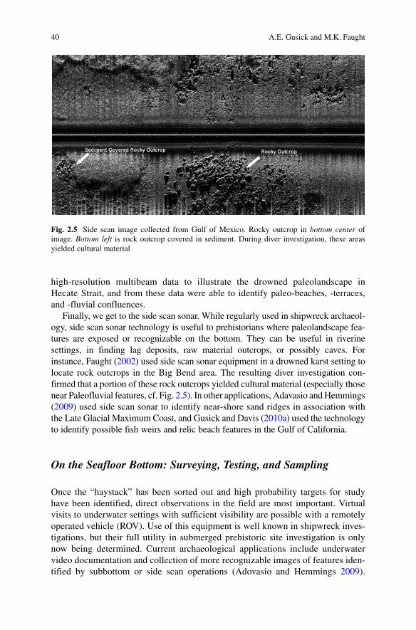
Finally, we get to the side scan sonar. While regularly used in shipwreck archaeol-ogy, side scan sonar technology is useful to prehistorians where paleolandscape fea-tures are exposed or recognizable on the bottom. They can be useful in riverine settings, in finding lag deposits, raw material outcrops, or possibly caves. For instance, Faught (2002) used side scan sonar equipment in a drowned karst setting to locate rock outcrops in the Big Bend area. The resulting diver investigation con-firmed that a portion of these rock outcrops yielded cultural material (especially those near Paleofluvial features, cf. Fig. 2.5). In other applications, Adavasio and Hemmings (2009) used side scan sonar to identify near-shore sand ridges in association with the Late Glacial Maximum Coast, and Gusick and Davis (2010a) used the technology to identify possible fish weirs and relic beach features in the Gulf of California.
On the Seafloor Bottom: Surveying, Testing, and Sampling
Once the “haystack” has been sorted out and high probability targets for study have been identified, direct observations in the field are most important. Virtual visits to underwater settings with sufficient visibility are possible with a remotely operated vehicle (ROV). Use of this equipment is well known in shipwreck inves-tigations, but their full utility in submerged prehistoric site investigation is only now being determined. Current archaeological applications include underwater video documentation and collection of more recognizable images of features iden-tified by subbottom or side scan operations (Adovasio and Hemmings 2009).
Fig. 2.5 Side scan image collected from Gulf of Mexico. Rocky outcrop in bottom center of image. Bottom left is rock outcrop covered in sediment. During diver investigation, these areas yielded cultural material
412 Prehistoric Archaeology Underwater
Features derived from the sonar equipment can be difficult to positively identify; therefore, collecting clear ROV images aids in determining if a feature should be investigated more thoroughly with a dive operation. This kind of technology is important to be developed for working in water deeper than 60 ft., as the amount of time a diver can remain at these depths is limited.
Although virtual site visits are possible, direct diver survey remains the most effective method for obtaining samples, for investigating targets more thoroughly, and for positively identifying cultural material. With SCUBA, divers breathe compressed air from a tank, or supplied from the surface with hoses. Experienced divers can dive deeper and stay longer by breathing mixtures of gases (increased oxygen, helium, or nitrogen mixtures), but these are not for the novice. In general, diving in depths less than 30 ft., is particularly easy and not time restricted, but the time a diver can remain underwater gets shorter with increasing depth and there are severe time restrictions on SCUBA diving deeper than 100 ft. It is at these greater depths that gas mixtures or closed-circuit rebreathers (CCR) are useful.
Fundamentally, the time underwater is always limited when compared with the way terrestrial archaeologists would spend getting to know their site. If a site is deeply submerged, an underwater archaeologist may only be able to work 3 h/day at the site. Prehistorians accustomed to ample time to draw strata and observe in the field should internalize this fact and learn to embrace and communicate specific and attainable goals for each season and each dive.
Effective sampling at a submerged archaeological site is another task that tends to be a bit more challenging than at a terrestrial site. Massive infield gridding, as often done on land, is a luxury underwater. It is often the case that sampling under-water takes place from central datum points from which collection transects can be sampled at regular intervals. Artifacts or other objects can be recorded by distance and bearing measures. Likewise, collection areas can be quadrilateral, but taking the time to set up a grid with actual pins on the bottom may not be the most efficient use of bottom dive time.
Coring remains the most useful way to collect sedimentary data and can be done relatively easily in an underwater context. Pearson et al. (1986) used a dense pattern core sampling project to test features and strata located with seismic records in order to identify terrestrial landforms in an area of the PaleoSabine River in the Gulf of Mexico. They were successful in identifying a probable midden at a considerable depth. Once a site can be identified, increased numbers of cores in tight patterns can be useful to determine the extent of sediment beds or boundaries of a site; however, cores are not usually effective in finding artifacts, and therefore in identifying sites, simply because the sample area is so small. That being said, Easton (1993, p. 9) collected a series of core samples from throughout the basin in Montague Harbour, British Columbia, that were effective in identifying stratified midden deposits as well as a “depositional sequence of basal clays, terrestrial soils, and marine sands.” Additionally, Gagliano et al. (1982) used geoarchaeological point count methods to identify anthropogenic sediment characteristics at known terrestrial sites. These data were then used to identify submerged sites by comparing characteristics within sediment from cores collected from probable inundated anthropogenic deposits.
42 A.E. Gusick and M.K. Faught
Another approach to subsurface testing, if the paleolandscape is not buried too deeply with marine sediment, is hand fanning. Equivalent to shovel testing terrestrially, divers can take samples at predetermined intervals by hand fanning up to a meter or more into unconsolidated sediments and collecting specimens (Muckelroy 1978, p. 28). Faught (2002, 2004) used hand fanning to good effect in a drowned karst environment in Florida, and Gusick and Davis (2010b) report its effectiveness in Baja California.
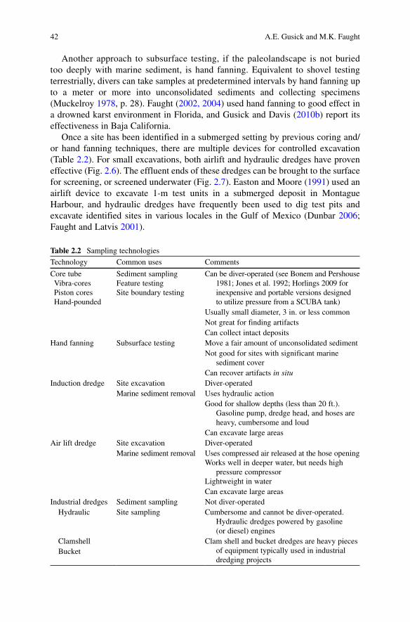
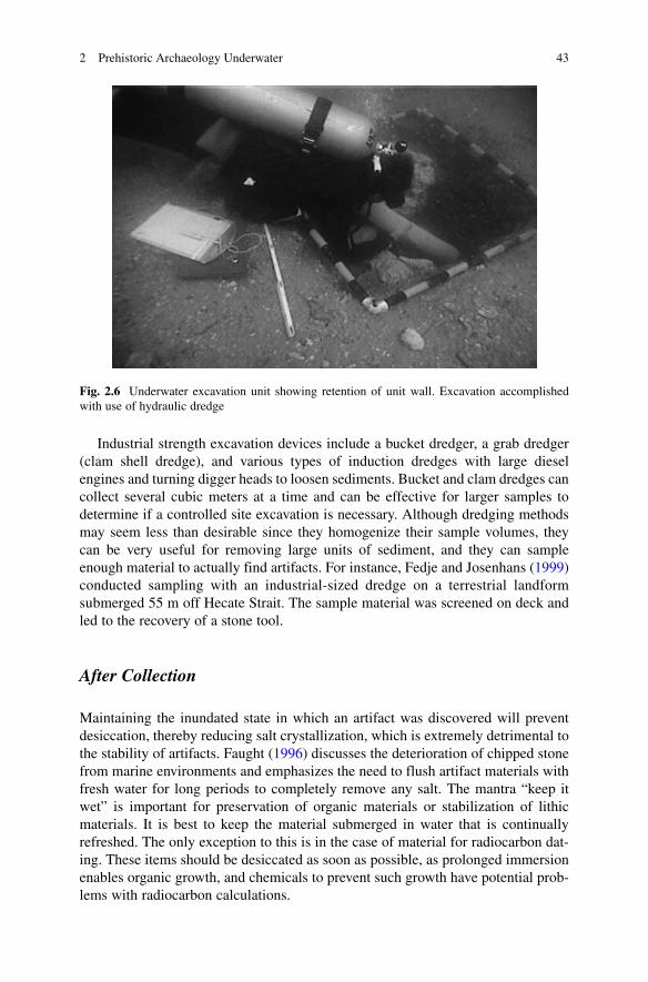
Once a site has been identified in a submerged setting by previous coring and/or hand fanning techniques, there are multiple devices for controlled excavation (Table 2.2). For small excavations, both airlift and hydraulic dredges have proven effective (Fig. 2.6). The effluent ends of these dredges can be brought to the surface for screening, or screened underwater (Fig. 2.7). Easton and Moore (1991) used an airlift device to excavate 1-m test units in a submerged deposit in Montague Harbour, and hydraulic dredges have frequently been used to dig test pits and excavate identified sites in various locales in the Gulf of Mexico (Dunbar 2006; Faught and Latvis 2001).
Table 2.2 Sampling technologies
Technology Common uses Comments
Core tubeVibra-coresPiston coresHand-pounded
Sediment samplingFeature testingSite boundary testing
Can be diver-operated (see Bonem and Pershouse 1981; Jones et al. 1992; Horlings 2009 for inexpensive and portable versions designed to utilize pressure from a SCUBA tank)
Usually small diameter, 3 in. or less commonNot great for finding artifactsCan collect intact deposits
Hand fanning Subsurface testing Move a fair amount of unconsolidated sedimentNot good for sites with significant marine
sediment coverCan recover artifacts in situ
Induction dredge Site excavation Diver-operatedMarine sediment removal Uses hydraulic action
Good for shallow depths (less than 20 ft.). Gasoline pump, dredge head, and hoses are heavy, cumbersome and loud
Can excavate large areasAir lift dredge Site excavation Diver-operated
Marine sediment removal Uses compressed air released at the hose openingWorks well in deeper water, but needs high
pressure compressor Lightweight in waterCan excavate large areas
Industrial dredges Sediment sampling Not diver-operated Hydraulic Site sampling Cumbersome and cannot be diver-operated.
Hydraulic dredges powered by gasoline (or diesel) engines
Clamshell Clam shell and bucket dredges are heavy pieces of equipment typically used in industrial dredging projects
Bucket
432 Prehistoric Archaeology Underwater
Fig. 2.6 Underwater excavation unit showing retention of unit wall. Excavation accomplished with use of hydraulic dredge
Industrial strength excavation devices include a bucket dredger, a grab dredger (clam shell dredge), and various types of induction dredges with large diesel engines and turning digger heads to loosen sediments. Bucket and clam dredges can collect several cubic meters at a time and can be effective for larger samples to determine if a controlled site excavation is necessary. Although dredging methods may seem less than desirable since they homogenize their sample volumes, they can be very useful for removing large units of sediment, and they can sample enough material to actually find artifacts. For instance, Fedje and Josenhans (1999) conducted sampling with an industrial-sized dredge on a terrestrial landform submerged 55 m off Hecate Strait. The sample material was screened on deck and led to the recovery of a stone tool.
After Collection
Maintaining the inundated state in which an artifact was discovered will prevent desiccation, thereby reducing salt crystallization, which is extremely detrimental to the stability of artifacts. Faught (1996) discusses the deterioration of chipped stone from marine environments and emphasizes the need to flush artifact materials with fresh water for long periods to completely remove any salt. The mantra “keep it wet” is important for preservation of organic materials or stabilization of lithic materials. It is best to keep the material submerged in water that is continually refreshed. The only exception to this is in the case of material for radiocarbon dat-ing. These items should be desiccated as soon as possible, as prolonged immersion enables organic growth, and chemicals to prevent such growth have potential prob-lems with radiocarbon calculations.
44 A.E. Gusick and M.K. Faught
Conclusions
Most important to underwater exploration in the New World, the examples listed throughout this paper illustrate the utility of employing systematic approaches to the location and sampling of offshore archaeological sites (see Flemming 1983; Geddes et al. 1983; Kraft et al. 1983; Masters 1983). The accomplishments to date in methodological development and research into submerged environments are extremely promising. By effectively combining information on environmental reconstructions with bathymetric surveys and knowledge of coastal settlement patterns, innovative archaeologists have developed and will continue to develop
Fig. 2.7 Image showing effluent end of hydraulic dredge dumping into a screen being monitored topside
452 Prehistoric Archaeology Underwater
newer and more effective methods for the study of submerged sites within their paleolandscape context. Our attempt to bring these efforts to light and to help move prehistoric marine archaeology into mainstream archaeological research is only part of what will undoubtedly be a long process. Strengthening the role of under-water archaeology as part of early coastal sites research would not only be extremely advantageous for research into the initial human migration into the New World but would also benefit any archaeologist investigating an ancient landscape that has been partially or fully submerged, no matter the time period of interest.
While we do feel it is important for archaeologists working in a coastal environ-ment to consider the seascape when developing project methods, there are areas in which the cost and time of conducting underwater studies may exceed the expected outcomes. Yet, there are thousands of miles of inundated coastline surrounding North America that do have the potential to yield prehistoric archaeological sites, but are largely unexplored. The inundation of these coastlines should not be a barrier that prevents researchers from collecting data that may help to evaluate major issues within archaeology. Indeed, coastal landscapes and the resources they provide have influenced some of the most significant developments in human history. Our ability to explore more fully these developments has been expanded through dedicated research focused on coastal landscapes. While much of this research has been terrestrially based, underwater paleocoastal research is rapidly becoming a viable and integral field in Anthropology. Our ability to more fully understand the behaviors of early maritime peoples, including the timing and nature of the peopling of the New World, may very well depend on locating data that has been submerged for the last 15,000 years.
Acknowledgments We would like to thank Nuno Bicho, Jonathan Haws, and Loren Davis for inviting us to contribute in this volume. Heiner Josenhans, Daryl Fedje, Patrick Bartier, and Loren Davis kindly shared their images for inclusion in our chapter. Ruth Gruhn, Alan Bryan, Loren Davis, and Michael Glassow provided helpful critiques and edits.
References
Adovasio, J.M. and A. Hemmings. 2009. Inner continental shelf archaeology in the northeast Gulf of Mexico, paper presented to the 74th annual meeting of the Society for American Archaeology, Atlanta.
Adovasio, J.M., J.D. Gunn, J. Donahue and R. Stuckenrath. 1978. Meadowcroft Rockshelter, 1977: an overview. American Antiquity 43: 632–651.
Andersen, S.H. 1987. Tybrind Vig: A submerged Ertebolle settlement in Denmark, in J.M. Coles and A.J. Lawson (Eds.) European wetlands in prehistory: 253–280. Oxford: Clarendon Press.
Bailey, G.N. and J. Parkington. 1988. The archaeology of prehistoric coastlines. Cambridge: Cambridge University Press.
Barton, C.M., G.A. Clark, D.A. Yesner and G.A. Pearson. 2004. The settlement of the American continents: a multidisciplinary approach to human biogeography. Tuscon: University of Arizona Press.
Bass, G.F. 1966. Archaeology under water. New York: Praeger.
46 A.E. Gusick and M.K. Faught
Bass, G.F. 1967 Cape Gelidonya: A Bronze Age shipwreck. Transactions of the American Philosophical Society 57: 3–177.
Blanton, D.B. and S.G. Margolin. 1994. An assessment of Virginia’s underwater cultural resources. Williamsburg: Virginia Department of History, William and Mary Center for Archaeological Research, Department of Anthropology.
Bonem, R.M. and J.R. Pershouse. 1981. Inexpensive, portable underwater coring device. Journal of Sedimentary Research 51: 654–656.
Bradley, B. and D. Stanford. 2004. The north Atlantic ice-edge corridor: A possible Palaeolithic route to the New World. World Archaeology 36: 459–478.
Clague, J.J. 1983. Glacio-isostatic effects of the Cordilleran ice sheet, British Columbia, Canada, in D.E. Smith and A.D. Dawson (Eds.) Shorelines and Isostacy: 321–343. London: Academic Press.
Clausen, C. J., A.D. Cohen, C. Emiliani, J.A. Holman and J.J. Stipp. 1979. Little Salt Spring, Florida: a unique underwater site. Science 203(4381): 609–614.
Davis, L.G., Jenevein, S.A., Punke, M.L., Noller, J.S., Jones, J.A., and Willis, S.C. 2009. Geoarchaeological themes in a dynamic coastal environment, Lincoln and Lane Counties, Oregon. In, J.E. O’Connor, R.J Dorsey and I.P. Madin (eds.), pp. 331–348, Volcanoes to Vineyards: Geologic Field Trips through the Dynamic Landscape of the Pacific Northwest. Geological Society of America Field Guide 15.
Dean, M., B. Ferrari, I. Oaley, M. Redknap and K. Watson (Eds.). 1995. Archaeology underwater: The NAS guide to principles and practice. Dorchester: Nautical Archaeology Society.
Des Lauriers, M.R. 2005. Rediscovering Huamalgua, the island of fogs: archaeological and ethnohistorical investigations of Isla Cedros, Baja California. Ph.D. thesis, University of California, Riverside.
Dixon, E.J. 2001. Human colonization of the Americas: timing, technology and process. Quaternary Science Reviews 20: 277–299.
Dixon, E. J., T.H. Heaton, T.E. Field, T.D. Hamilton, D.E. Putnam and F. Grady. 1997. Late Quaternary regional geoarchaeology of southeast Alaska karst: a progress report. Geoarchaeology 12: 689–712.
Driskell, B.N. 1996. Stratified Late Pleistocene and Early Holocene deposits at Dust Cave, north-western Alabama, in D.E. Anderson and K.E. Sassaman (eds.) The Paleoindian and Early Archaic Southeast: 315–30. Tuscaloosa: University of Alabama Press.
Dunbar, J.S. 1997. Inundated Paleoindian and Archaic sites of the coastal margins and continental shelf in the southeastern United States, paper presented to the 163rd annual meeting of the American Association for the Advancement of Science, Seattle.
Dunbar, J.S. 2006. Paleoindian Archaeology, in S.D. Webb (Ed.) First Floridians and last mastodons: the Page-Ladson site in the Aucilla River: 403–435. Dordrecht: Springer
Dunbar, J.S., M.K. Faught and S.D. Webb. 1988. Page/Ladson (8Je591): an underwater Paleo-Indian site in northwestern Florida. The Florida Anthropologist 41(3): 442–452.
Easton, N.A. (Ed.) 1993. Underwater archaeology in Montague Harbor: report on the 1992 field investigations, Occasional papers of the Northern Research Institute, Research Report No. 4.
Easton, N.A. and C. Moore. 1991. Test excavations of subtidal deposits at Montague Harbor, British Columbia, Canada - 1989. The International Journal of Nautical Archaeology 20: 269–280.
Emery, K.O. and R.L. Edwards. 1966. Archaeological potential of the Atlantic continental shelf. American Antiquity 31: 733–737.
Erlandson, J.M. 1993. Evidence for a Pleistocene human occupation of Daisy Cave, San Miguel Island. Current Research in the Pleistocene 10: 17–21.
Erlandson, J.M. 1994. Early hunter-gatherers of the California coast. New York: Plenum.Erlandson, J.M. 2001. The archaeology of aquatic adaptations: paradigms for a new millennium.
Journal of Archaeological Research 9: 287–350.Erlandson, J.M. 2002. Anatomically modern humans, maritime voyaging, and the Pleistocene
colonization of the Americas, in N. Jablonski (Ed.) The first Americans: the Pleistocene colonization of the New World: 59–92. San Francisco: California Academy of Sciences.
Erlandson, J.M. and R.H. Colten (Eds.). 1991. Hunter-gatherers of Early Holocene coastal California. Los Angeles: Institute of Archaeology, University of California.
472 Prehistoric Archaeology Underwater
Erlandson, J.M., D.J. Kennett, B.L. Ingram, D.A. Guthrie, D.P. Morris, M.A. Tveskov, G.J. West and P.L. Walker. 1996. An archaeological and paleontological chronology for Daisy Cave (CA-SMI-261), San Miguel Island, California. Radiocarbon 38(2): 355–373.
Evans, A., R. Floyd and M. Keith. 2007. Identifying offshore prehistoric sites from remote sensing data: preliminary site investigation in the Gulf of Mexico, paper presented to the 72nd annual meeting for the Society for American Archaeology, Austin.
Fairbanks, R.G. 1989. A 17, 000-year glacio-eustatic sea level record: influence of glacial melting rates on the Younger Dryas event and deep-ocean circulation. Nature 342: 637–642.
Faught, M.K. 1996. Clovis origins and underwater prehistoric archaeology in northwestern Florida. Ph.D. thesis, University of Arizona, Tuscon.
Faught, M.K. 2002. Submerged Paleoindian and Archaic sites of the big bend, Florida. Journal of Field Archaeology 29: 273–290.
Faught, M.K. 2004. The underwater archaeology of paleolandscapes, Apalachee Bay, Florida. American Antiquity 69: 235–249.
Faught, M.K. 2008. Archaeological roots of human diversity in the New World: a compilation of accurate and precise radiocarbon ages from earliest sites. American Antiquity 73: 670–698.
Faught, M.K. and J.F. Donoghue. 1997. Marine inundated archaeological sites and paleofluvial systems: examples from a karst controlled continental shelf setting in the Apalachee Bay, northeastern Gulf of Mexico. Geoarchaeology 12: 417–458.
Faught, M.K. and A.E. Gusick. 2011. Submerged Prehistory in the Americas, in J. Benjamin, C. Bonsall, C. Pickard and A. Fischer (Eds.) Submerged Prehistory: 145–157. Oxford: Oxbow Books.
Faught, M.K. and J.M. Latvis. 2001. PaleoAucilla prehistory project: underwater prehistoric archaeology in Apalachee Bay 1999 interim report, program in underwater archaeology research reports no. 1. Tallahassee: Florida State University.
Fedje, D.W. and T. Christensen. 1999. Modeling paleoshorelines and locating Early Holocene coastal sites in Haida Gwaii. American Antiquity 64: 635–652.
Fedje, D.W. and H. Josenhans. 1999. A prehistoric stone tool recovered from a deeply drowned fluvial fan in Hecate Strait, British Columbia, Canada. Manuscript on file, Parks Canada, Victoria.
Fedje, D.W. and H. Josenhans. 2000. Drowned forests and archaeology on the continental shelf of British Columbia, Canada. Geology 28: 99–102.
Fedje, D.W., R.J. Wigen, D. McClaren and Q. Mackie. 2004. Pre-Holocene archaeology and environment from karst cases in Haida Gwaii, west coast, Canada, paper presented to the 57th Annual Northwest Anthropological Conference, Eugene.
Fillon, R.H. 2006. Glacioeustatic sea level, gas hydrate stability, and a Late Pleistocene shelf-edge delta in the northeast Gulf of Mexico: environmental factors controlling shelf-margin stability and the probable record for pre-Clovis man in North America, poster presented to the Geological Society of America Annual Meeting, Philadelphia.
Fischer, A. 1995. Man and sea in the Mesolithic: coastal settlement above and below present sea level. Oxford: Oxbow Monograph 53.
Fladmark, K.R. 1979. Routes: alternative migration corridors for early man in North America. American Antiquity 44: 55–69.
Flemming, N.C. 1983. Preliminary geomorphological survey of an Early Neolithic submerged site in the Sporadhes, N. Aegean, in P.M. Masters and N.C. Flemming (Eds.) Quaternary coast-lines and marine archaeology: towards the prehistory of land bridges and continental shelves: 233–268. London: Academic Press.
Fujita, H. and G. Poyatos de Paz. 1998. Settlement patterns on Espiritu Santo Island, Baja California Sur. Pacific Coast Archaeological Society Quarterly 34: 67–105.
Gagliano, S.M., C.E. Pearson, R.A. Weinstein, D.E. Wiseman and C.M. McClendon. 1982. Sedimentary studies of prehistoric archaeological sites: criteria for the identification of submerged archaeological sites of the Northern Gulf of Mexico continental shelf, report prepared for the U.S. Department of the Interior National Park Service, Division of State Plans and Grants, Contract No. C35003(79).
48 A.E. Gusick and M.K. Faught
Galili, E. and M. Weinstein-Evron. 1985. Prehistory and paleoenvironments of submerged sites along the Carmel coast of Israel. Paleorient Paris 11: 37–52.
Garrison, E.G. 2000. A geoarchaeological study of Prisoner’s Harbor, Santa Cruz Island, Northern Channel Islands, California - past sea levels and delatic deposits of an insular stream, in C.J. Donlan, B.R. Tershy, B.S. Keitt and B. Wood (Eds.) Proceedings of the 5th California Islands Symposium: 531–540. Santa Barbara: Santa Barbara Museum of Natural History.
Garrison, E.G. 2006. Two Archaeological and Paleontological Locatilities on the Atlantic Southeastern U.S Continental Shelf, Gray’s Reef National Marine Sanctuary and J-Reef (Georgia), poster presented to the annual meeting of the Geological Society of America, Philadelphia.
Geddes, D.S., J. Guilaine and A. Monaco. 1983. Early Neolithic occupation on the submerged continental plateau of Roussillon (France), in P.M. Masters and N.C. Flemming (Eds.) Quaternary coastlines and marine archaeology: towards the prehistory of land bridges and continental shelves: 175–188. London: Academic Press.
Gifford, J.A. 1983. Core sampling of a Holocene marine sedimentary sequence and underlying Neolithic cultural material off Franchthi Cave, Greece, in P.M Masters and N.C. Flemming (Eds.) Quaternary coastlines and marine archaeology: towards the prehistory of land bridges and continental shelves: 269–282. London: Academic Press.
Glassow, M.A. 2006. Early to Middle Holocene occupation on Santa Cruz Island, paper presented to the 40th Annual Society for California Archaeology Conference, Ventura.
Glassow, M.A., J. Perry and P. Paige. 2008. The Punta Arena site: Early and Middle Holocene development on Santa Cruz Island. Santa Barbara: Santa Barbara Museum of Natural History.
Gould, R. A. 2000. Archaeology and the social history of ships. Cambridge: Cambridge University Press.
Gruhn, R. 1988. Linguistic evidence in support of the coastal route of earliest entry into the New World. Man 23: 77–100.
Gruhn, R. and A.L. Bryan. 2002. An interim report on two rockshelter sites with Early Holocene occupation in the northern Baja California peninsula, in M. Wilken-Robertson, M. Santos Mena, M.E. Castillo Sarabia and D. Laylander (Eds.) 2nd binational symposium: balances and perspectives on the anthropology and history of Baja California. Ensenada: Instituto de Culturas Nativas de Baja California: Instituto Nacional de Antropologia e Historia.
Gusick, A.E. and L.G. Davis. 2010a. Exploring Baja California’s submerged landscapes. Journal of California and Great Basin Anthropology 30(1): 35–49.
Gusick, A.E. and L.G. Davis. 2010b. Sea of Cortez 2010: exploring Mexico’s submerged land-scapes, paper presented at 4th Annual Explorers Symposium at the National Geographic Society, Washington DC.
Henshilwood, C.S., J.C. Sealy, R. Yates, K. Cruz-Uribe, P. Goldberg, F.E. Grine, R.G. Klein, C. Poggenpoel, K. van Niekerk and I. Watts. 2001. Blombos Cave, Southern Cape, South Africa: preliminary report on the 1992–1999 excavations of the Middle Stone Age levels. Journal of Archaeological Science 28: 421–448.
Horlings, R. 2009. An effective diver-operated coring device for underwater archaeology. Technical Briefs in Historical Archaeology 4: 1–6.
Hoyt, W.H., J.C. Kraft and M.J. Chrzastowski. 1990. Prospecting for submerged archaeological sites on the continental shelf; southern mid-Atlantic bight of North America, in N.P Lasca and J. Donahue (Eds.) Archaeological geology of North America: centennial special volume 4. Boulder: Geological Society of America.
Inman, D.C. 1983. Application of coastal dynamics to the reconstruction of paleocoastlines in the vicinity of La Jolla, California, in P.M Masters and N.C. Flemming (Eds.) Quaternary coast-lines and marine archaeology: towards the prehistory of land bridges and continental shelves: 1–50. London: Academic Press.
Jacobsen, T.W. 1973. Excavation in the Franchthi Cave, 1969–1971, part I. Hesperia, 42: 45–88.Jones, B., K.F. Phimester, I.G. Hunter and P. Blanchon. 1992. A quick, inexpensive, self-contained
sediment coring system for use underwater. Journal of Sedimentary Research 62: 725–728.
492 Prehistoric Archaeology Underwater
Josenhans, H.W., D.W. Fedje, K.W. Conway and J.V. Barrie. 1995. Post glacial sea levels on the western Canadian continental shelf: evidence for rapid change, extensive subaerial exposure, and early human habitation. Marine Geology 125: 73–94.
Josenhans, H.W., D.W. Fedje, R. Pienitz and J. Southon. 1997. Early humans and rapidly changing Holocene sea levels in the Queen Charlotte Islands-Hecate Strait, British Columbia, Canada. Science 277: 71–74.
Keefer, D.K., S.D. deFrance, M.E. Moseley, J.B. I. Richardson, D.R. Satterlee and A. Day-Lewis. 1998. Early maritime economy and El Niño events at Quebrada Tacahuay, Peru. Science 281: 1833–1835.
Kennett, D. 2005. The island Chumash: behavioral ecology of a maritime society. Berkeley: University of California Press.
Kraft, J.C., D.F. Bellknap and I. Kayan. 1983. Potentials of discovery of human occupation sites on the continental shelves and nearshore coastal zones, in P.M Masters and N.C. Flemming (Eds.) Quaternary coastlines and marine archaeology: towards the prehistory of land bridges and continental shelves: 87–120. London: Academic Press
Leach, P.A. and D.F. Belknap. 2007. Marine geophysical and vibracoring applied to refining the search for submerged prehistory in Damariscotta River, Maine, USA, in L. Wilson, P. Dickinson and J. Jeandron (Eds.) Reconstructing human-landscape interactions: 141–158. Newcastle: Cambridge Scholars Publication.
Leach, P.A. and F. Daniel. 2006. Marine geoarchaeological investigation in Damariscotta River, Maine, USA, poster presented to the annual meeting of the Geological Society of America, Philadelphia.
Mandryk, C.A.S., H. Josenhans, D.W. Fedje and R.W. Mathewes. 2001. Late Quaternary paleoen-vironments of northwestern North America: implications for inland versus coastal migration routes. Quaternary Science Reviews 20: 301–314.
Masters, P.M. 1983. Detection and assessment of prehistoric artifact sites off the coast of southern California, in P.M Masters and N.C. Flemming (Eds.) Quaternary coastlines and marine archaeology: towards the prehistory of land bridges and continental shelves: 189–214. London: Academic Press
Masters, P.M. 1996. Paleocoastlines, ancient harbors, and marine archaeology. Shore and Beach 64: 8–17.
Masters, P.M. and N.C. Flemming. 1983. Quaternary coastlines and marine archaeology: towards the prehistory of land bridges and continental shelves. London: Academic Press.
McLaren, D., Q. Mackie, D.W. Fedje, A. Martindale and D. Archer. 2007. Relict shorelines and archaeological prospection on the continental hinge of north coastal British Columbia, paper presented to the 72nd annual meeting for the Society for American Archaeology, Austin.
Merwin, D. 2006. Submerged prehistoric archaeological deposits in the New York bight, poster presented to the annual meeting of the Geological Society of America, Philadelphia.
Muckelroy, K. 1978. Maritime archaeology. Cambridge: Cambridge University Press.Muckelroy, K. 1980. Archeology under water: an atlas of the world’s submerged sites. New York:
McGraw-Hill.O’Shea, J.M. and G.A. Meadows. 2009. Evidence for early hunters beneath the Great Lakes.
Proceedings of the National Academy of Sciences 106: 10120–10123.Pearson, C.E., D.B. Kelley, R.A. Weinstein and S.M. Gagliano. 1986. Archaeological investiga-
tions on the outer continental shelf: a study within the Sabine River valley, offshore Louisiana and Texas. Washington, DC: US Dept. of Interior, Minerals Management Service.
Peltier, W.R. 2002. On eustatic sea level history: late glacial maximum to Holocene. Quaternary Science Reviews 21: 377–396.
Punke, M.L. and L.G. Davis. 2006. Problems and prospects in the preservation of Late Pleistocene cultural sites in southern Oregon coastal river valleys: implications for evaluating coastal migration routes. Geoarchaeology: An International Journal 21: 333–350.
Rick, T.C., J.M. Erlandson and R.L. Vellanoweth. 2001. Paleocoastal marine fishing on the Pacific Coast of the Americas: perspectives from Daisy Cave, California. American Antiquity 66: 595–613.
50 A.E. Gusick and M.K. Faught
Rick, T.C., D.J. Kennett and J.M. Erlandson. 2005. Preliminary report on the archaeology and paleoecology of the abalone rocks estuary, Santa Rosa Island, California, in D. Garcelon and C. Schwemm (Eds.) Proceedings of the Sixth California Islands Symposium: 55–63. Arcata: National Park Service Technical Publication CHIS-05-01, Institute for Wildlife Studies.
Sandweiss, D.H., H. McInnis, R.L. Burger, A. Cano, B. Ojeda, R. Paredes, M.C. Sandweiss and M.D. Glascock. 1998. Quebrada Jaguay: early South American maritime adaptations. Science 281: 1830–1832.
Schlee, S. 1978. On almost any wind: the saga of the oceanographic research vessel “Atlantis”. London: Cornell University Press.
Scuvée, F. and J. Verague. 1988. Le gisement sous-marin du Paléolithique moyen de l’anse de la mondrée à Fermanville, Manche. Cherbourg: C.E.H.P-Littus.
Singer, R. and J.J. Wymer. 1982. The middle Stone Age at Klasies River mouth in South Africa. Chicago: University of Chicago Press.
Stiner, M.C. 1999. Paleolithic mollusc exploitation at Riparo Mochi (Balzi Rossi, Italy): food and ornaments from the Aurignacian through the Epigravettian. Antiquity 73: 735–754.
Stothert, K.E. 1985. The preceramic Las Vegas culture of coastal Ecuador. American Antiquity 50: 613–637.
Straus, L., J.L. Bischoff and E. Carbonell. 1993. A review of the Middle to Upper Paleolithic transition in Iberia. Prehistoire Europeenne 3:11–26.
Stright, M.J. 1990. Archaeological sites on the North American continental shelf, in N.P Lasca and J. Donahue (Eds.) Archaeological geology of North America: centennial special volume 4: 439–465. Boulder: Geological Society of America.
Stright, M.J. 1995. Archaic period sites on the continental shelf of North America: the effects of relative sea-level changes on archaeological site locations and preservation, in E.A.I. Bettis (Ed.) Archaeological Geology of the Archaic Period in North America: 131–147. Geological Society of America Special Paper 297.
Throckmorton, P. 1970. Shipwrecks and archaeology: the unharvested sea. Boston: Little, Brown.
Walter, R.C., R.T. Buffler, J.H. Bruggemann, M.M.M. Guillaume, S.M. Berhe, B. Negassi, Y. Libsekal, H. Cheng, R.L. Edwards, R. von Cosel, D. Neraudeau and M. Gagnon. 2000. Early human occupation of the Red Sea coast of Eritrea during the last interglacial. Nature 405: 65–69.
Waters, M.R. and T.W. Stafford Jr. 2007. Redefining the age of Clovis: implications for the peopling of the Americas. Science 315: 1122–1126.
Webb, S.D. 2006. First Floridians and last mastodons: the Page-Ladson site in the Aucilla River. Dordrecht: Springer.
Werz, B. and N.C. Flemming. 2001. Discovery in Table Bay of the oldest handaxes yet found underwater demonstrates preservation of hominid artefacts on the continental shelf: news and views. South African Journal of Science 97: 183–185.
Yesner, D.R. 1987. Life in the “garden of Eden”: causes and consequences of the adoption of marine diets by human societies, in M. Harris and E.B. Ross (Eds.) Food and evolution: toward a theory of human food habit: 285–310. Philadelphia: Temple University Press.