Embed Size (px)
Citation preview

Chapter – 2Physical Features
2.1 Geographical Disposition
The Par-Tapi-Narmada link canal, its proposed six reservoirs, twobarrages, two tunnels, six power houses, feeder canals and command areaare located in the basins of west flowing rivers from Par to Tapi, Tapi andNarmada. The basins of west flowing rivers from Par to Tapi lie betweennorth latitudes 20o 13’ to 21o 14’ and east longitudes 72 o 43’ to 73 o 58’. TheTapi basin lies between north latitudes 20 o 05’ to 22 o 03’ and east longitudes72 o 38’ to 78 o 17’ while the Narmada basin lies between north latitudes 21o
20’ to 23o 45’ and east longitudes 72o 32’ to 81o 45’. The link traversesbetween Par and Narmada from south to north. Index map showing rivers,basin boundaries, State boundaries, dams etc is appended at Plate 1.1 inVolume-VII.
2.2 Topography of the Basins, Reservoirs and Command Area
The link canal passes through Par, Auranga, Ambica, Purna,Mindhola, Tapi and Narmada basins. Physiographic map of the adjoiningarea of the Par-Tapi-Narmada link project is at Fig - 2.1. Each of the basinsis described below separately:
2.2.1 Par Basin
The Par river is one of the important west flowing rivers in the region,north of Mumbai and south of the Tapi river. The river rises in the Sahyadrihill ranges at an elevation of about 1100 m above mean sea level in Nasikdistrict of Maharashtra State and traverses a distance of 131 km beforedraining into the Arabian Sea. The Par river travels mostly through hillscovered with forest and patches of cultivated lands on banks of river.
The basin lies in the States of Maharashtra and Gujarat and has aeffective catchment area of 1648 km2. The percentages of the area of thebasin in the States of Maharashtra and Gujarat are 46.91% and 53.09 %
59
respectively. The basin is part of the Western Ghats portion in Maharashtraand Gujarat and is covered by Deccan traps.
2.2.2 Auranga Basin
The Auranga is one of the important west flowing rivers in the regionnorth of Mumbai city and south of Tapi river. The river is known as Aurangaafter the confluence of its two tributaries the Man and the Tan. Bothtributaries originate in the Sahyadri hill ranges in the Nasik district ofMaharashtra State. The river traverses a distance of about 30 km fromconfluence of the tributaries before draining into the Arabian Sea. The
60

effective drainage area of the Auranga basin is 748 km2, out of which 150km2 is in Maharashtra State and 598 km2 is in Gujarat State. The area is hillyand covered with forest in the upstream reaches, while the area down-wardsfrom about 15 km upstream of confluence of the Tan and the Man rivers canbe described as plain with cultivated lands.
The Tan river rises at an elevation of about 645 m and the elevationwhere it meets the Man river is about 50 m. The length of the river upto itsconfluence with Man river is 52 km. The catchment area of the Tan riverupto its confluence with Man river is 289 km2, out of which 68 km2 lies inNasik district of Maharashtra State and the balance 221 km2 lies in theValsad and Navsari district of Gujarat State.
2.2.2 Ambica Basin
The Ambica which is a west flowing river, rises in the Sahyadri hillranges in the Nasik district of Maharashtra State at an elevation of about1050 m above MSL and after traversing a total distance of 164 km joins theArabian Sea in the State of Gujarat. The effective drainage area of theAmbica basin 2685 km2 out of which 102 km2 lies in Maharashtra and 2583km2 is in Gujarat. The important tributaries of the Ambica river are Khapri,Kaveri and Kharera rivers.
The Khapri river rises at an altitude of 1030 m in Sahyadri hill rangein Ahwa taluka of Dang district in the State of Gujarat and joins the riverAmbica near village Milan at an elevation of 100 m. The length of riverKhapri is about 80 km. The Khapri catchment upto its confluence withAmbica river is spread over an area of 537 km2 which is about 19% of thetotal catchment of the Ambica basin.
2.2.4. Purna Basin
The river Purna, a west flowing river, rises in the Sahyadri hillranges of the Western Ghats at an elevation of about 1300 m in the Ahwataluka of Dang district in the State of Gujarat and after traversing a distanceof 180 km, it outfalls into the Arabian sea. The level of the river bed dropssteeply from 1300 m at source to about 115 m at the dam site as the river in
61
this reach passes through hilly area covered with dense forest and patches ofcultivated land. The effective drainage area of the basin is 2193 km2, out ofwhich 58 km2 lies in Maharashtra State and 2135 km2 lies in the State ofGujarat.
The important tributaries of the Purna river are Girra, Jankhari andDamaskhadi rivers.
2.2.5 Tapi Basin
The Tapi basin is bounded on the north by the Satpura range, on eastby the Mahadeo hills, on the south by the Ajanta range and the Satmala hillsand on the west by the Arabian Sea. The basin has an elongated shape with amaximum length of 587 km east to west and maximum width of 201 kmfrom north to south. The basin has two well-defined physical regions, viz.the hilly region and the plains. The hilly region covers the Satpuras, theSatmalas, the Ajanta and the Gawilgarh hills with good forests. TheKhandesh and the Gujarat plains are broad and fertile areas suitable forcultivation. The Tapi basin consists mainly of black cotton soils. The coastalplains in Gujarat are composed of alluvial clays with a layer of black soil onthe surface.
2.2.6 Narmada Basin
The Narmada basin is bounded on the north by the Vindyas, on theeast by the Maikalu range, on the south by the Satpura and on the west bythe Arabian Sea. The basin has five well defined physiographic regions.They are:(1) The upper hilly areas covering the districts of Shahdol,Mandla, Durg, Balaghat and Seoni;(2) The upper plains covering the districsof Jabalpur, Narsimhapur, Sagar, Damoh, Chhindwara, Hoshangabad, Betul,Raisen and Sehore: (3) The middle plains covering the districts of EastNimar, part of west Nimar, Dewas, Indore and Dhar; (4) The lower hillyareas covering part of the west Nimar, Jhabua, Dhulia, Narmada and parts ofVadodara; and (5) The lower plains covering mainly the districts ofNarmada, Bharuch and parts of Vadodara. The hill regions are wellforested. The upper, middle and lower plains are broad and fertile areas,well suited for cultivation. The Narmada basin mainly consists of black
62
soils. The coastal plains in Gujarat are composed of alluvial clays with alayer of black soils on the surface.
2.2.7 Topography of the Reservoirs
Six storage reservoirs are proposed for storing and diverting the waterthrough Par-Tapi-Narmada link. These are Jheri dam across Par river;Paikhed dam across Nar river (a tributary of Par river); Chasmandva damacross Tan river (a tributary of Auranga river); Chikkar dam across Ambicariver; Dabdar dam across Khapri river (a tributary of Ambica river); andKelwan dam across Purna river. The Jheri reservoir is entirely lies inMaharashtra whereas, Dabdar and Kelwan reservoirs lies entirely in Gujarat.Other reservoirs namely Paikhed, Chasmandva and Chikkar reservoirs lie inboth Gujarat and Maharashtra. The topographical details of six reservoirsare detailed below:
The Jheri dam is proposed across Par River near village ‘Jheri’ inPeint taluka of Nasik district of Maharashtra State. Paikhed dam isproposed across Nar River (a tributary of Par) near village ‘Paikhed’ inDharampur taluka of Valsad district of Gujarat State. It is proposed to divertsurplus waters from Jheri reservoir to Paikhed reservoir through 12.70 kmlong inter-connecting tunnel. The combined waters will be released throughthe Dam toe Power House of Paikhed dam into Nar river and tapped atPaikhed barrage, proposed at about 4.60 km downstream near village ‘NaniCoswadi’ of Dharampur taluka, and let into the Link Canal which off-takesfrom Paikhed barrage.
The Chasmandva dam is proposed across Tan River (a tributary ofAuranga) near village ‘Chasmandva’ in Dharampur taluka. The surpluswaters of Tan River released through the Dam toe Power House ofChasmandva dam will be tapped at Chasmandva barrage, proposed at about8.50 km downstream near village ‘Chandha Chikadi’ of Dharampur taluka,and will be diverted into the Link Canal by a Feeder Pipeline of about 2.859km long.
The Chikkar dam is proposed across Ambica River near village‘Chikkar’ in Ahwa taluka of the Dangs district in Gujarat State. The surplus
63

water of Ambica River will be diverted through a 14.342 km long inter-connecting Pipeline into Dabdar reservoir after power generation at Chikkardam toe Power House. The Dabdar dam is proposed across Khapri River (atributary of Ambica) near village ‘Dabdar’ in Ahwa taluka of the Dangsdistrict. The combined surplus flows of Ambica and Khapri Rivers will bediverted into the Link Canal through a 12.258 km long Feeder Pipeline afterpower generation at Dabdar dam toe Power House.
The Kelwan dam is proposed across Purna River near villages‘Kelwan’ and ‘Kakarda’ in Ahwa taluka of The Dangs district. The surpluswaters of Purna River will be fed to the Link Canal through a 7.616 km longFeeder Pipeline after power generation at Kelwan dam toe Power House.Another Power House is proposed at RD 5.80 km of the Kelwan feederPipeline where considerable drop in ground level is observed.
2.2.8 Topography of the Command Area
(i) Topography
Topography of the command area is undulating and of moderateslope. The command area in Valsad district comprises of Deccan trap Basalt.Basaltic out crops are seen in Vansda taluka of Navsari district in which theCommand area lies. The command area in the Dangs district comprises ofDeccan trap Basalt. The Command Area in Tapi district is comprises ofDeccan trap Basalt of Cretaceous-Eocene age, which is overlain byquaternary alluvium. Limestone and clay formation of Eocene ages andquaternary alluvium formation are seen in Command Area lying in Suratdistrict. In the eastern side of Bharuch district, where the Command Arealies, Basaltic rocks are seen.
(ii) Land Slopes
Slopes of the lands in the command are generally moderate neithersteep nor flat.
(iii) Soils
64

The taluka wise reports of the soil survey carried out by GujaratGovernment in respect of the districts falling in the en-route command areahave been collected from the Agriculture Department, Government ofGujarat. Reports on land irrigability and soil classification of Banni area ofKutchh region and SSNNL phase I (Upto Mahi river), Soil classificationreport and soil maps for the talukas lying in reservoir submergence areasand link alignment have also been collected. Using this information the soilmap of the enroute command area has been prepared and appended at Plate-4.45 in Volume -VII.
The soils in the command area can be broadly classified into 3 maincategories viz. i) Deep Black, Medium Black to Loamy Sand (Goradu) soils,ii) Deep Black with Alluvial, Laterite and Medium Black Soils and iii)Deep Black Clayey Soils.
2.3 Geology of the Basins, Reservoirs and Command Area2.3.1 Geology of the Basins
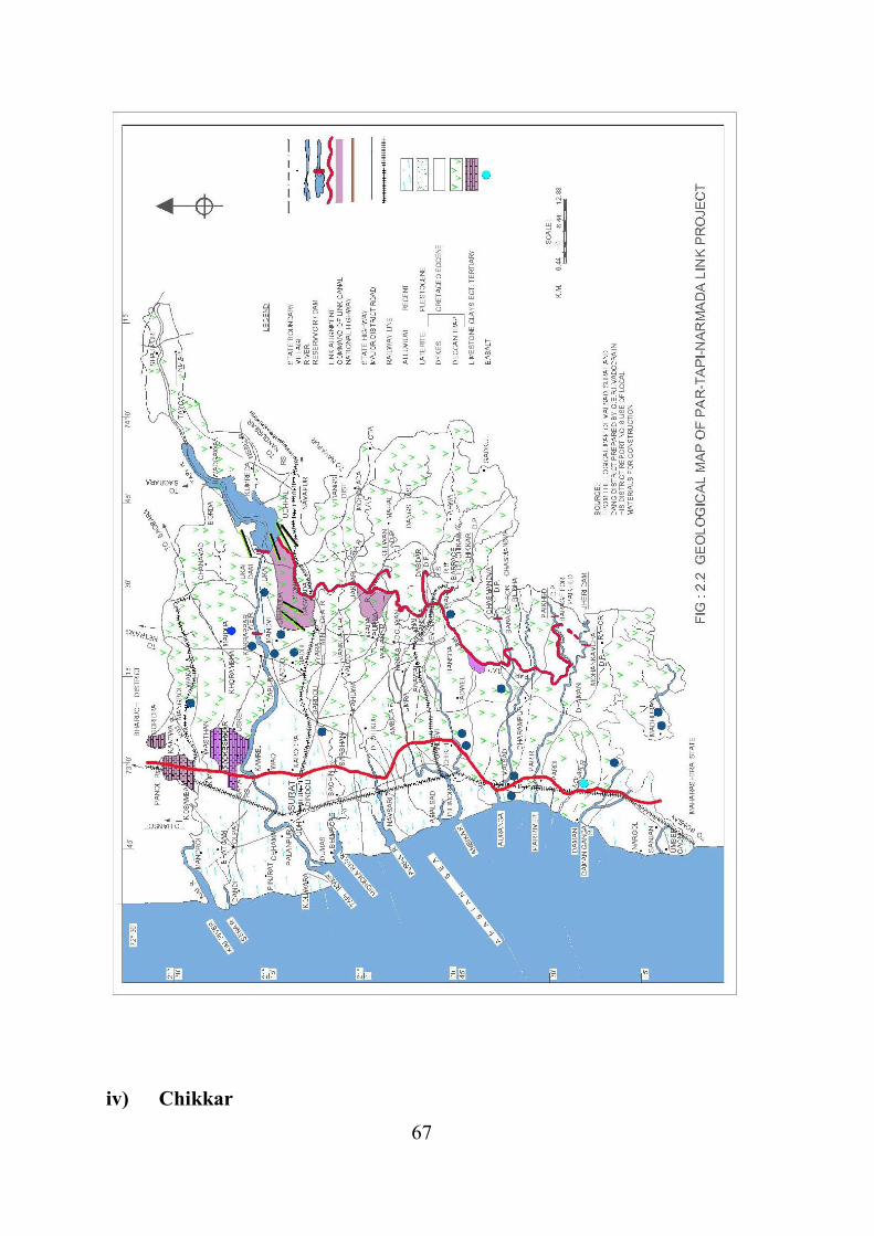
The major part of the ‘Par-Tapi’ portion of the link canal and itsenroute command areas are covered by Deccan trap basalts with isolateddeposits of laterite. The geological formations in Par and Auranga basinswhere Paikhed and Chasmandva dam sites lie, belong to the Precambrian,melipozoice, tertiary and quatertiary ages. Deccan traps which occupymajor portion of upper reaches are of two prominent types, one being darkgrey to bluish black which are hard, compact and massive and the otherbeing light brown to pink which are soft.
Like in Par and Auranga basins, Deccan traps with dykes occupymost of the areas of Ambica basin in which Chikkar ad Dabdar dam sites areproposed. The geological formations found in Ambica basin include thoseof the Quaternary and Tertiary ages. The middle ranges have developed onthe Deccan traps and the intermediate amphitheatres have developed out ofthe alluvial debris washed out from the hills. The lower reaches of the basincontain mainly alluvial plains upto coastal margins.
65

Deccan traps also occupy most parts of Purna basin in which Kelwandam site is proposed. In the east, there are high ridges and deep valleys andtowards the west, they merge into the lower reach composed of recent andsub-recent alluvium and sand. The stratigraphical sequences of the rocksfound in the basin are Neogene, Paleogene and early Paleogene. Ageological map Par-Tapi-Narmada link is at Fig - 2.2.
2.3.2 Geology of Reservoirs
i) Jheri
The Jheri reservoir area is thickly forested and restricted to the valleywith steep hills on both sides. Amygdular basalts which are jointed andsheared are encountered in the area. No major fault or shear zone was notedin the area.
ii) Paikhed
In the Paikhed reservoir area the Basalts of the Deccan trap formsfoundation rock. The rocks have horizontal to sub horizontal dips. Thewater percolation test results of these bore holes indicate that the strata ingeneral have low permeability but higher values of equivalent permeabilityup to 15 lugeons since the rocks in the area have a horizontal to subhorizontal disposition.
iii) ChasmandvaIn the Chasmandva reservoir area the basaltic flows of Deccan Trap formfoundation rock. The rock has horizontal to sub horizontal disposition withlow permeability.
66
iv) Chikkar
67

The Chikkar reservoir area consists sub horizontal sequence of lavaflows of Deccan traps. The contacts zone between the successive lava flowsare moderately to highly weathered and marked by presence of flowbreccias, with predominance of Amygdule.
v) Dabdar
The Dabdar reservoir area consists of Deccan traps. The bed rockconstituting the foundation are a sequence of lava flows, which comprisesAmygdaloidal, dense, perphyritic basalt and flow breccias with horizontal tosub horizontal dips.
vi) Kelwan
The Kelwan reservoir area consists of Deccan traps and it’sdifferentiates. The exposed out crops are mainly consisting of horizontal tosub horizontal sequence of lava flows, which includes Amygdaloidal, dense,perphyritic basalt and flow breccias.
2.3.3 Geology of Command Area
The proposed Command Area of the link canal lies in Valsad,Navsari, Dangs, Tapi, Surat and Bharuch, Chhota Udepur and Panchmahaldistricts of Gujarat State.
Geologically the Valsad district comprises of Deccan trap with dykesof quaternary and tertiary ages. The middle ranges have developed onDeccan trap and the intermediate amphitheatres have developed out of thealluvial debris washed from the hills. The lower reaches are mainly alluvialplains.
Geologically the Navsari district comprises of Alluvium (Clay andSand) and Trap. Basaltic out crops are seen in Vansda taluka in which theCommand area lies. Ground water availability in alluvial formations issatisfactory. In Trap area, the availability of ground water is less. Theground water quality in the Command area is good.
68

Geologically the Dangs district is composed of Deccan trap Basalt.Basalt acts as poor aquifer. The water quality is very good.
Geologically the Tapi district is comprises of Deccan trap Basalt ofCretaceous-Eocene age, which is overlain by quaternary alluvium. Theground water availability is poor in hard rock area but its quality is good.
Limestone and clay formation of Eocene ages and quaternaryalluvium formation are seen in Surat district. The ground water availabilityand quality is good in the proposed Command Area.
Geologically, Bharuch district is mainly divided in two types of rocks.Alluvial formations are seen in western side. In the eastern side, where theCommand area lies, Basaltic rocks are seen. Ground water availability andquality is good in the proposed Command Area. Overall, the level ofgroundwater development in the proposed Command area of the link projectcan be categorized as “Safe”.
Geologically, in Chhota Udepur district, Rocks of highly intricate andvaried gneissic complex; they are mostly of igneous origin, but on accountof interfoliar injection, they have a general northerly foliation strike, and arecontinuous with gneissic complex of Central Mewar.
Geologically, in Panchmahals district Rocks of Aravali System(including Champaners) are Metamorphic and have been affected bytectonic forces forming folds. Basal conglomerates, an impure calcareousfacies generally dolomitic in composition, quartzite, phyllites, slates andschists are the rocks under this system. Phyllites are common rocks andoccupy large areas with quartzite as intercalations: phyllites grade intoschists.
2.4 River System and Catchment Area
Each river system and its catchment area intercepted by the Par-Tapi-Narmada link is described below:
69

2.4.1 Par Basin
Par is a west flowing river with its catchment area lying inMaharashtra and Gujarat. It rises at an elevation of 1100 m in the Sahyadrihill ranges near village Gogul of Surgana taluka in Nasik district ofMaharashtra. After traversing a distance of about 131 km, it drains intoArabian sea. The important tributaries of the Par river are Aroti, Nar,Bhimtas, Vajri and Keng.
The Par basin lies between North latitudes 20o 16’ and 20o 35’ andEast longitudes 72o 54’ and 73o 44’ with effective drainage area of 1648km2.
The basin can be divided into two prominent physiographic zones.The eastern part comes under rugged mountain chains of the Sahyadri hillsand descends on the western side to the edge of the uplands of Valsaddistrict. This region is placed at a steep slope of elevation 1050 m to 100 m.The Western part, barring the coastal plains, is essentially in the sub-Sahyadrian zone of hills and valley generally lies at an elevation below 100m.
Deccan traps with dykes of quaternary and tertiary ages occupy mostof the area of the basin. The middle ranges have developed on the Deccantraps and the intermediate amphitheatres have developed out of the alluvialdebris washed from the hills. The lower reaches of the basin upto the coastalmargins are mainly alluvial plains.
2.4.2 Auranga Basin
Auranga is a west flowing river with its catchment in Gujarat andMaharashtra. The river is known as Auranga after the confluence of its 2tributaries viz., Man and Tan. The rivers Man and Tan originate in the
70

Sahyadri hill ranges near village Dongar and Kuranjul respectively inSurgana taluka in Nasik district of Maharashtra. The length of Man and Tanrivers upto their confluence is 78 km and 49 km respectively. The Aurangariver traverses a distance of about 30 km after the confluence of Man andTan rivers before draining into the Arabian sea.
Auranga basin lies between north latitudes 200 30' and 200 42' andeast longitudes 720 53' and 730 37' with effective drainage area of 748 km2.A portion of Valsad and Navsari districts of Gujarat and Nasik district ofMaharashtra falls in this basin.
The basin forms part of the Western Ghats in Gujarat.
Physiographically, the basin can be divided into 5 groups namely,
1. Hill tops and hill slopes, 2. Hill terraces and uplands, 3. Upper and lower foot slopes (medium land), 4. Valley plains and local depressions (low lands) and 5. River and stream beds.
Geological formations in the region belong to the Precambrian,mellpozoic, tertiary and quarternary ages. Deccan traps occupy majorportion of the upper reaches. They are of two prominent types viz. dark greyto bluish black which are hard, compact and massive and the light brown topink which are soft.
2.4.3 Ambica Basin
Ambica is a west flowing river with its catchment area in Gujarat andMaharashtra. It rises in the Sahyadri hill ranges near village Kotambi ofSurgana taluka in Nasik district of Maharashtra. After traversing a distanceof about 164 km, it drains into the Arabian Sea. Important tributaries ofAmbica river are Khapri, Olan, Kaveri and Kharera.
Ambica basin lies between latitudes 20o 31' N and 20o 57' N andlongitudes 72o 48' E and 73o 52' E with effective drainage area of about
71
2685 km2. Valsad, Dangs and Surat districts of Gujarat and a small portionof Nasik district of Maharashtra fall in this basin.
Basin can be divided into 2 prominent physiographic zones. Theeastern part comes under rugged mountain chains of the Sahyadri hills anddescends on the western side to the edge of the uplands of Surat district.This region is placed at a general elevation of 1050 to 100 m. Western part,barring the coastal plains, is essentially in the sub-Sahyadrian zone of hillsand valleys generally below 100 m elevation.
Deccan traps with dykes of quaternary and tertiary ages occupy mostof the area of the basin. The middle ranges have developed on the Deccantraps and the intermediate amphitheatres have developed out of the alluvialdebris washed from the hills. Lower reaches of the basin upto the coastalmargins are mainly alluvial plains.
2.4.4 Purna Basin
Purna is a west flowing river with its catchment in Gujarat andMaharashtra. The river rises in the Salher hills in the Western Ghats nearvillage Chinchi at an elevation of about 1300 m in Maharashtra State. Totallength of the river from its source to outfall in the Arabian Sea is about 180km. Important tributaries of the river are Dhodar Nallah, Barda nallah,Nagihpar nallah, Girra river, Zankhari river and Dumas khadi.
Purna basin lies between East longitude of 720 44’ and 730 58’ andNorth latitudes of 200 44’ and 210 06’ and effective drains an area of 2193km2.
Basin can be divided in 2 prominent physiographic Zones. Theeastern part comes under rugged mountain chains of the Sahyadri hills anddescends on the western side to the edge of the uplands of Surat district. Theregion is placed at a general elevation of 1300 to 100 m. Western part,barring the coastal plains, is essentially in the sub-sahyadrian zone of hillsand valleys and generally below 100 m elevation.
72

Deccan traps occupy major portion of the upper reaches. In the east,there are high ridges and deep valleys and towards the west, they merge intothe lower reach composed of recent and sub recent alluvium and blownsand. Stratigraphical sequences of the rocks found in the basin are neogene,paleogene and early paleogene. Availability of ground water is restricted toweathered residues and fractured zones.
2.4.5 Tapi Basin
The river Tapi which is the second largest west flowing inland river ofthe peninsula rises near Betul district of Madhya Pradesh at an elevation of752 m. In the head reach for a distance of about 241 km, the river traversesthrough an open and partially cultivated plain before plunging into a rockygorge in the Satpura hills. The Tapi basin extends over an area of 65,145km2 and lies between north latitudes 20o 5’ to 22o 3’ and east longitudes 72o
38’ to 78o 17’ situated in the Deccan plateau. The basin covers a drainagearea of 9804 km2 in Madhya Pradesh, 51,504 km2 in Maharashtra and 3837km2 in Gujarat. The important tributaries joining from the left are the Purna,the Vaghur, the Girna, the Bori, the Panjhra and from the right the Aner.The drainage area of the Tapi basin upto Ukai dam is 62,225 km2 of which9,804 km2 in Madhya Pradesh, 51,504 km2 in Maharashtra and 917 km2 inGujarat. The Tapi basin consists of mainly black soil. The coastal plains inGujarat have alluvial soil with black soil on the surface.
2.5 Basin Characteristics 2.5.1 Rainfall
Par Basin
Basin receives about 97% of the annual rainfall during the South-West monsoon from June to September. The maximum, minimum andannual average rainfall in the basin is 2669 mm, 1920 mm and 2180 mmrespectively
Auranga Basin
73

Basin receives most of the rainfall from South-West monsoon duringJune to September. 97% of the rainfall occurs during monsoon season.Rainfall during non-monsoon season is meager. Maximum, minimum andaverage annual rainfall recorded in the basin are 2406 mm,1644 mm and2055 mm respectively.
Ambica Basin
Basin receives most of the rainfall from south-west monsoon duringJune to September. About 98% of the rainfall occurs during the monsoonseason. Rainfall during non-monsoon months is meager. Maximum,minimum and average annual rainfall recorded in the basin is 2520 mm,1460 mm and 1830 mm respectively.
Purna Basin
Basin receives about 97% of the annual rainfall during south-westmonsoon from June to September. Maximum, minimum and annualaverage rainfall of in the basin is 1972 mm, 782 mm, and 1472 mmrespectively.
Tapi Basin
The basin comes under the direct influence of the south-westmonsoon and receives heavy and assured rainfall between June and August.The rainfall gradually decreases from Karnataka in the south to Gujarat inthe north. The south-west monsoon rainfall is usually very heavy. 90% ofthe rainfall occurs from June to November.
2.5.2 Temperature, Relative Humidity, Wind Speed and Cloud Cover
Two meteorological observatories viz., Surat and Vadodaramaintained by IMD located adjacent to the project area have been used tocharacterize the climatic condition of the project area. The normaltemperature, relative humidity, wind speed and cloud cover observed atSurat IMD observatory (based on the data for the period from 1998 to 2007)
74

and Vadodara IMD observatories (based on the data for the period from1998 to 2007) are as follows.
Temperature:
Monthly mean maximum and minimum temperatures recorded atSurat and Vadodara stations are 36.8 0C and 14.7 0C and 39.9 0C and 13.2 0Crespectively.
Humidity:
Monthly mean maximum and minimum relative humidity recorded atSurat and Vadodara stations are 90% and 53% and 94% and 44%respectively.
Wind Speed:
Monthly mean maximum and minimum wind speed recorded at Suratand Vadodara stations are 6.4 km/h and 1.7 km/h and 13.3 km/h and 2.2km/h respectively.
Cloud Cover:
Monthly mean maximum and minimum wind speed recorded at Suratand Vadodara stations are 6.2 oktas and 0.7 oktas and 6.4 oktas and 0.8oktas respectively.
75