Embed Size (px)
Citation preview

Bronx River Greenway Strategic Plan Greenway Route from South to NorthDraft 03/30/06 Page 1
CHAPTER 2: GREENWAY ROUTE FROM SOUTH TO NORTH
The Bronx River Alliance is the single organization that tracks the implementation of the NewYork City portion of the Bronx River Greenway—a continuous bike and pedestrian path that willextend into Westchester County to run the full 23-mile length of the river. The greenway willopen up new green space in neighborhoods which now lack it and enhance existing parks. Inaddition, the greenway will connect neighborhoods currently separated by highways, railroads,and other barriers and provide Bronxites greater access to the borough’s many cultural andrecreational amenities.
The Greenway Team—planners, designers, and advocates from the community andgovernment—guides the planning and implementation of the Bronx River Greenway. Ourcollaborative approach ensures that Bronx residents stand on equal footing with designers andagency representatives in discussing design concepts and implementation priorities for thegreenway.
In this chapter, we travel what will be the complete route in the Bronx—from the river’s mouth atthe East River to the border with Westchester County. Some sections of the greenway—particularly in the north—already exist and require only modest path improvements or therealignment of problem intersections. However, in the South Bronx the greenway is carving outnew parkland along the river, creating acres of new green space and access to the waterfrontfor communities that have long been deprived of these amenities.
In the following description, the greenway is divided into five segments, according to varyingcharacteristics of the greenway and the different agencies involved in its design andconstruction. For each segment of the greenway, we describe the route that users will travel, aswell as its relevant history and future plans. Connections to other greenways and on-streetroutes are also identified, to relate the Bronx River Greenway to the City’s larger network ofbicycle and pedestrian paths, and as a reference for users who may at times prefer on-streetroutes for security or better connection to their destinations.

Bronx River Greenway Strategic Plan Greenway Route from South to NorthDraft 03/30/06 Page 2
SEGMENT A – EAST RIVER TO BRUCKNER BOULEVARDThe southernmost segment of the Bronx River Greenway will include dedicatedpathways on both sides of the river to Bruckner Boulevard. One segment of thegreenway will run along the east side of the river from Soundview Park; the otheroriginates on the west side of the river at Hunts Point Riverside Park.
East Side of the River – Soundview Park to Bruckner BoulevardOn the east side of the Bronx River, a new greenway path will run from the southeastcorner of Soundview Park along the water to the northwest corner of park (at Colgateand Lafayette Avenues). From there, the greenway will be a Class One, two-way bikeand pedestrian pathway along Colgate, Story, and Bronx River Avenues to theintersection with Bruckner Boulevard.

BroDra
1.
2.
3.
4.
5.
An alternative route would be made possible by the redevelopment of the Loral site, avacant industrial property bounded by the river,Story Avenue, Colgate Avenue, and LafayetteAvenue. Rezoning of this site for residential orcommercial use would subject future developmentto the provisions of New York City’s WaterfrontZoning regulations, requiring continuous publicaccess along the river. A waterfront pathwayalong the Loral site would connect Bronx RiverAvenue directly to the new greenway path inSoundview Park.
ReresTheestCoclohisobt
CoThirecAvewadanove
At Paconan devTheeveGrewill10-Gre
1 Acstrebut
SEGMENT A COMPONENTPROJECTS - EAST
Soundview Park bikeway, Phase I completed in 2001
Soundview Park bikeway, Phase II
Bruckner-Soundview connection
Soundview Park Fieldhouse
Soundview Point River Access
nx River Greenway Strategic Plan Greenway Route from South to Northft 03/30/06 Page 3
The New York City Department of Parks &creation has additional improvements planned for Soundview Park—including lagoontoration, the creation of active and passive recreational spaces and an amphitheater.se are among the many Bronx park projects funded under the mitigation agreement
ablished as a condition for the construction of the Croton Filtration Plant in Vanrtlandt Park. Soundview Park is a former landfill used for construction debris and wassed in the 1960’s. Capital projects in the park are encountering delays due to the longtory of intensive land use on the site. Currently, delays in the Park involve difficultyaining the necessary permits from DEC to proceed with construction.
nnections to Other Greenways and On-Street Routess segment of the Bronx River Greenway makes connections to the followingommended routes1 listed on the 2005 New York City Cycling Map: Bronx Rivernue, Lafayette Avenue, and Rosedale Avenue. However, cyclists should be
rned that crossing Bruckner Boulevard on Bronx River Avenue is an extremelygerous intersection. Cyclists should use great caution or use the pedestrian bridger the elevated Bruckner Expressway at Elder Street.
the southeastern corner of Soundviewrk, the Bronx River Greenway willnect to the Ferry Point Park Greenway,eight-mile greenway now beingeloped along the East River waterfront. Ferry Point Park Greenway willntually connect to the Hutchinson Riverenway, which via the Pelham Greenway loop users back to the Bronx River, in amile loop. The Hutchinson Riverenway is currently under construction.
2002 Tour de Bronx in Soundview Park
cording to the map, available at http://www.nyc.gov/html/dcp/html/bike/cwbm.shtml, recommended routes areets identified by the New York City Departments of Transportation and City Planning as generally suitable for cycling,which are not striped or sign-posted.
Bronx River Greenway Strategic Plan GreenDraft 03/30/06
An on-street alternative for users traveling from the southeast on Leland Avenue to Bronx RiverAvenue is:
Left on Patterson Avenue
Right on St. Lawrence Avenue
Left on Lacombe Avenue
Right on Rosedale Avenue
Left on Randall Avenue
Right on Metcalf Avenue
Left on Lafayette Avenue
Right on Colgate Avenue
Left on Story Avenue
Right on Bronx River Avenue (proceed with caution at intersection with BrucknerBoulevard!)
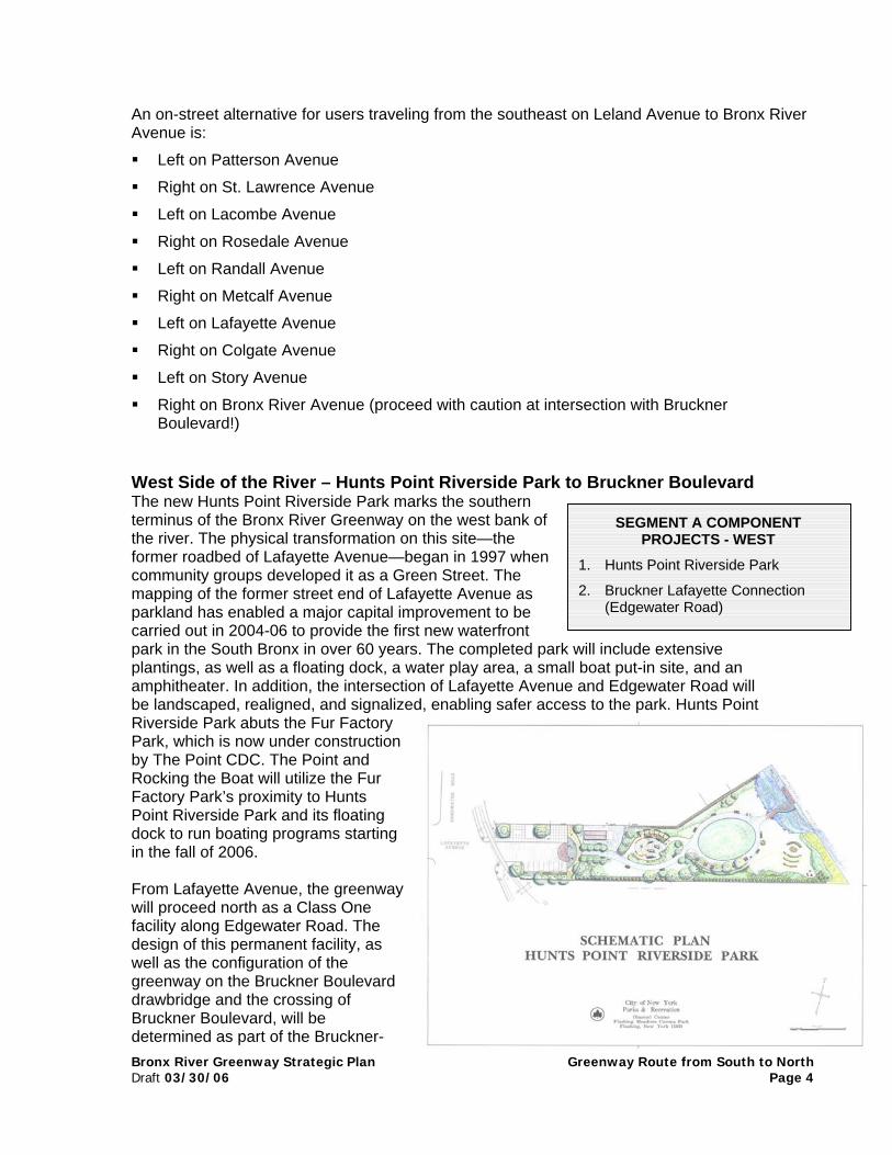
West Side of the River – Hunts Point Riverside Park to Bruckner BoulevardThe new Hunts Point Riverside Park marks the southernterminus of the Bronx River Greenway on the west bank ofthe river. The physical transformation on this site—theformer roadbed of Lafayette Avenue—began in 1997 whencommunity groups developed it as a Green Street. Themapping of the former street end of Lafayette Avenue asparkland has enabled a major capital improvement to becarried out in 2004-06 to provide the first new waterfrontpark in the South Bronx in over 60 years. The completed park will inplantings, as well as a floating dock, a water play area, a small boatamphitheater. In addition, the intersection of Lafayette Avenue and be landscaped, realigned, and signalized, enabling safer access to Riverside Park abuts the Fur FactoryPark, which is now under constructionby The Point CDC. The Point andRocking the Boat will utilize the FurFactory Park’s proximity to HuntsPoint Riverside Park and its floatingdock to run boating programs startingin the fall of 2006.
From Lafayette Avenue, the greenwaywill proceed north as a Class Onefacility along Edgewater Road. Thedesign of this permanent facility, aswell as the configuration of thegreenway on the Bruckner Boulevarddrawbridge and the crossing ofBruckner Boulevard, will bedetermined as part of the Bruckner-
1. H
2. B(
SEGMENT A COMPONENTPROJECTS - WEST
unts Point Riverside Park
ruckner Lafayette ConnectionEdgewater Road)
way Route from South to NorthPage 4
clude extensive put-in site, and anEdgewater Road willthe park. Hunts Point

Bronx River Greenway Strategic Plan Greenway Route from South to NorthDraft 03/30/06 Page 5
Sheridan Environmental Impact Study, now being carried out by NYSDOT. Under any ofthe alternatives being studied—ranging from the construction of a major highwayinterchange at Bruckner Boulevard and Edgewater Road, to the elimination of theSheridan and the creation of an elevated interchange at Leggett Avenue—the BrucknerExpressway through lanes will be removed from their current street level. Elevation ofthe express lanes would allow for major bicycle and pedestrian improvements both alongand across Bruckner Boulevard. A Draft EIS is expected in mid-2006, and construction isslated to begin in 2011/2012.2 In the meantime, Parks has allocated TEA-21 fundsprovided by Congressman Serrano to design an interim route for this crucial segment ofthe greenway.
Until the Bruckner Sheridan interchange is resolved, the nearest point at which it is physicallypossible to cross Bruckner Boulevard is at its intersection with Bronx River Avenue, on the eastside of the river. From Edgewater Road, bikers and pedestrians must travel east to Bronx RiverAvenue and there cross underneath the Bruckner Expressway. Cyclists and pedestriansshould be aware that this intersection is extremely dangerous and that they shouldproceed with caution or use the pedestrian bridge over the elevated BrucknerExpressway at Elder Street. From the north Bruckner Service Road, users can double-backover the north side of the drawbridge to reach the Concrete Plant Park (see page 19), which iscurrently under construction until 2007. Upon the eventual realignment of the Bruckner-Sheridanintersection (no earlier than 2015), this crossing will be much easier as users will be able tocross directly underneath the newly-elevated Bruckner at Edgewater Road to enter theConcrete Plant.
Connections to Other Greenways and On-Street RoutesAt Lafayette Avenue, the Bronx River Greenway will connect to the planned South BronxGreenway, which will run through Hunts Point and Port Morris to Randal’s Island. A planningstudy for the South Bronx Greenway was completed in 2005, under a contract being overseenby New York City Economic Development Corporation (EDC).3
2 Refer to NYSDOT’s website for an up-to-date schedule for the Bruckner-Sheridan EIS and construction process:http://www.dot.state.ny.us/reg/r11/bese/milestones.html 3 For more information about the South Bronx Greenway, see Sustainable South Bronx’s website athttp://www.ssbx.org/greenway.html
Segment A Outstanding Issues Overcoming delays at Soundview Park—coordinating with DEC on permits
Resolution of the Bruckner-Sheridan Interchange to enable final design for the Brucknercrossing
Configuration of an interim on-street greenway path along Edgewater Road

Bronx River Greenway Strategic PlanDraft 03/30/06
SEGMENT B – BRUCKNER BOULEVARD TO E. TREMONTAVENUE
The Concrete Plant ParkFrom Bruckner Boulevard, the greenway route proceeds north through the city-owned siteknown as the Concrete Plant Park. This site has a storied past—suspected as having ties to theMafia, the plant went bankrupt in 1987 after theowner was convicted on price-fixing charges.The site was then acquired by New York Citywith the intention of auctioning it off. However, inresponse to community pressure the Citywithdrew it from public auction in 1999 andagreed to set it aside as parkland.
The Concrete Plant has been used as a publicpark since 2000, when control of the site wastransferred to Parks. During this time, atemporary, bark-mulched pathway led northdown the steep slope from Bruckner Boulevard,connecting to an extensive, concrete-paved area
SEGMENT B COMPONENT PROJECTS
1. Concrete Plant Park, Phase I (demolition)
2. Concrete Plant Park, Phase II (site work)
3. Concrete Plant Park, Phase III (additionalimprovements)
4. Westchester Avenue crossing
5. Apex Auto and PDJ Simone
6. Starlight Park—east and west bank
7. E. Tremont Avenue /Devoe Ave / e. 177th
St intersection
Greenway Route from South to NorthPage 6

Bronx River Greenway Strategic Plan Greenway Route from South to NorthDraft 03/30/06 Page 7
and the mapped but unimproved section of Edgewater Road that exits the site to the north, atWestchester Avenue. The Concrete Plant was also used to house a native plant nursery usedby Parks NRG to provide plant stock for ecological restoration throughout the Bronx. In addition,boat storage containers were used by the Alliance and partners for events and activities and byRocking the Boat, a nonprofit organization that teaches boat-building and on-water skills to localyoung people.
Construction of the Concrete Plant willbe implemented over three phases.Phase I of construction, whichinvolves the demolition of severalstructures and the stabilization ofremaining ones, began in the summerof 2005. Some of the steel structuressurviving as remnants of the formerconcrete batching operation will bestabilized and retained as sculpturalelements of the site. In future phases,they may be used to support windturbines and solar panels to provideenergy for park buildings and lighting.
View from the Concrete Plant on the Bronx River, looking north
Phase II of the Concrete Plant Park’s development will create a number of improvements,including a continuous greenway, a waterfront promenade, a modular classroom, new plantings,small boat access, space for cookouts and outdoor performances, an improved connection toBruckner Boulevard, and restoration of shoreline vegetation.
Final design for Phase III, which encompasses the area west of Edgewater Road,cannot be completed until the Bruckner-Sheridan and Access to Hunts Point PeninsulaEIS is finished in 2007, since all of the alternatives under consideration for the Bruckner-Sheridan Interchange would have important impacts on this site. In addition, full build-outof the Concrete Plant Park cannot take place until the reconstruction of the Bruckner-Sheridan Interchange is completed (projected 2015), since a portion of the site isproposed to be used for construction access and staging. However, once NYSDOTdecides on an alternative, work could begin on planning and design.
Adjacent to the Concrete Plant Park is a vacant railroad station designed in 1910-11 bythe legendary architect Cass Gilbert for the New York, New Haven & Hartford Rail Road.The station stands directly west of the site’s exit at Westchester Avenue above what arenow Amtrak’s North East Corridor tracks. Youth Ministries for Peace and Justice is nowstudying the feasibility of restoring the station building for a use that would serve as acommunity gateway to the Concrete Plant Park.
Westchester Avenue to East Tremont AvenueThe Bronx River Greenway from Westchester Avenue to East Tremont Avenue is beingimplemented by NYSDOT, with coordination with Parks and the Bronx River Alliance.
Bronx River Greenway Strategic Plan Greenway Route from South to NorthDraft 03/30/06 Page 8
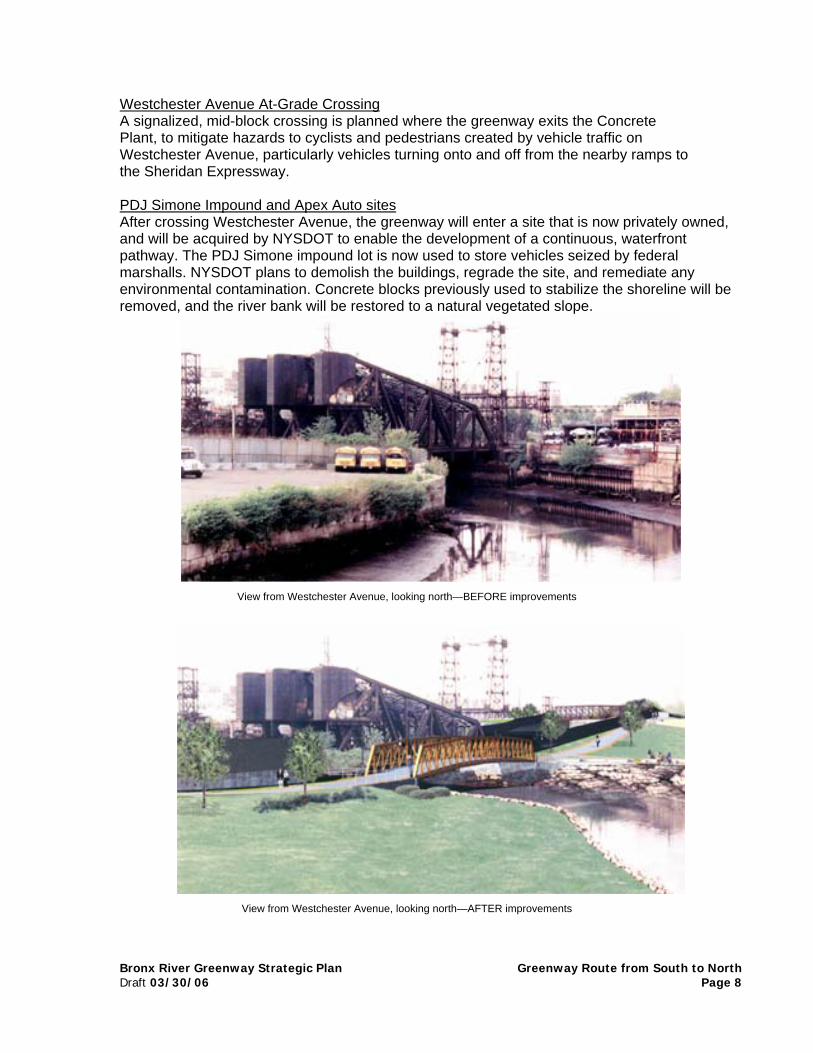
Westchester Avenue At-Grade CrossingA signalized, mid-block crossing is planned where the greenway exits the ConcretePlant, to mitigate hazards to cyclists and pedestrians created by vehicle traffic onWestchester Avenue, particularly vehicles turning onto and off from the nearby ramps tothe Sheridan Expressway.
PDJ Simone Impound and Apex Auto sitesAfter crossing Westchester Avenue, the greenway will enter a site that is now privately owned,and will be acquired by NYSDOT to enable the development of a continuous, waterfrontpathway. The PDJ Simone impound lot is now used to store vehicles seized by federalmarshalls. NYSDOT plans to demolish the buildings, regrade the site, and remediate anyenvironmental contamination. Concrete blocks previously used to stabilize the shoreline will beremoved, and the river bank will be restored to a natural vegetated slope.
View from Westchester Avenue, looking north—BEFORE improvements
View from Westchester Avenue, looking north—AFTER improvements
Bronx River Greenway Strategic Plan Greenway Route from South to NorthDraft 03/30/06 Page 9
The pathway will cross the river on a new, prefabricated steel truss bridge to access theparcel currently occupied by Apex Auto, an auto salvage operation. This site is over 600feet long, but has only two, widely separated 20-foot segments of street frontage. Theremainder of the site is a long sliver of land bounded by Amtrak to the west, and a row ofattached residential buildings to the east on Bronx River Avenue.
The greenway will exit the north end of the Apex Auto site at East 172nd Street, turn west onto anew bridge above the Amtrak line, and descend via several switchbacks to near river level. Herethe pathway will branch, offering users two options. One is to continue along the east bank ofthe river, on now-undeveloped land owned by Parks. The other is to cross a third new bridgeand enter Starlight Park on the west bank. The two paths re-connect over a fourth new bridgenorth of Starlight Park to form a one-mile loop along the river.
Starlight ParkStarlight Park was developed in the 1960’s, in conjunction with the construction of the SheridanExpressway. A private amusement park of the same name was condemned by Robert Mosesfor the Sheridan right-of-way; the present Starlight Park was constructed as a replacement.Though the surrounding communities suffer from a lack of open space and recreationalfacilities, Starlight Park was poorly utilized due to its poor condition, outdated recreationalfacilities, and difficulty of access.
An agreement negotiated in 2001 between NYSDOT and Parks permitted the utilization ofStarlight Park as a staging area for the reconstruction of the Sheridan Expressway by NYSDOT.This agreement also provided for the installation of an upgraded stormwater collection andtreatment system for runoff from theSheridan underneath the park. Inexchange, NYSDOT committed funds fora major reconstruction and upgrade ofthe park, and assigned its landscapearchitects to work closely with localresidents on the redesign.
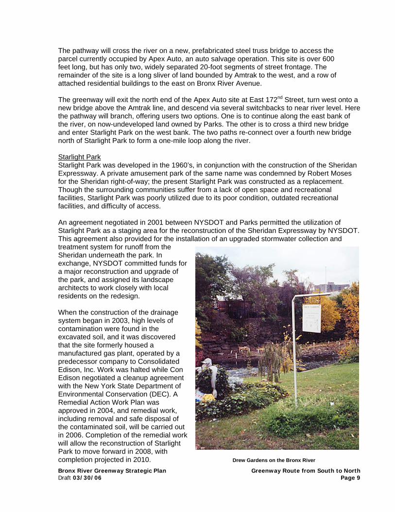
When the construction of the drainagesystem began in 2003, high levels ofcontamination were found in theexcavated soil, and it was discoveredthat the site formerly housed amanufactured gas plant, operated by apredecessor company to ConsolidatedEdison, Inc. Work was halted while ConEdison negotiated a cleanup agreementwith the New York State Department ofEnvironmental Conservation (DEC). ARemedial Action Work Plan wasapproved in 2004, and remedial work,including removal and safe disposal ofthe contaminated soil, will be carried outin 2006. Completion of the remedial workwill allow the reconstruction of StarlightPark to move forward in 2008, withcompletion projected in 2010. Drew Gardens on the Bronx River

Bronx River Greenway Strategic Plan Greenway Route from South to NorthDraft 03/30/06 Page 10
The reconstructed park will include a continuous pathway along the river (the river wascompletely fenced off in the former park configuration). A comfort station and boat storagebuilding will also be constructed in latter phases by Parks, with funding provided byCongressman José E. Serrano. Funds from the mitigation funds from the Croton Filtration Plantwill enable Parks to expand on the boat storage building, to provide space for community eventsand environmental programming, and for the headquarters of the Bronx River Alliance itself—allat the south end of Starlight Park. The Rebuild / Renew NY Transportation Bond which passedin November 2005 will fund a floating dock to enable small boat users to launch and cross the172nd Street weir even at low tide. An additional path will run along the east side of the riverfrom 172nd to 174th Streets.
Starlight Park to East Tremont AvenueNorth of Starlight Park, the greenway crosses below the Cross-Bronx Expressway and entersland that became parkland under an agreement between Parks, NYSDOT, the New York CityDepartment of Environmental Protection (DEP), and the Metropolitan Transit Authority (MTA).
North of the Cross-Bronx Expressway, NYSDOT plans to reconfigure the intersection ofE. 177th Street, Devoe Avenue, and E. Tremont Avenue, in front of the new MTA busstation. The new design significantly greens the street, improves safety, and calms trafficat what is currently a confusing and hazardous location. In addition, the parcel of landbounded by those streets will be converted from an illegal parking lot into a park and anatural, vegetated slope down to the river will be restored. On the opposite bank of theriver at this location is Drew Gardens, a community and educational garden. The 2-acrebotanical and vegetable garden was developed in 1995 by the Phipps CommunityDevelopment Corporation.
The greenway will cross E. Tremont Avenue at a signalized mid-block crossing, bringingusers to Bronx Street.
Connections to Other Greenways and On-Street RoutesThis segment of the Bronx River Greenway connects to Bronx River Avenue, which north of theBruckner Expressway is a recommended route listed on the 2005 New York City Cycling Map.
The on-street detour for cyclists, pedestrians, and rollerbladers traveling from the ConcretePlant Park at Westchester Avenue and who wish to connect to E. Tremont Avenue is thefollowing:
At the intersection with Whitlock Avenue, cross Westchester Avenue
Right onto Home Street
At the triangle, bear right ontoWest Farms Road
Right onto E. Tremont Avenue
Segment B Outstanding Issues Final Phase III design for the Concrete Plant Park (area
to be used as staging area for the Sheridan)
Programming and security on the greenway, whereentrance and egress are limited (Concrete Plant Park,Westchester – E. Tremont)
Bronx River Greenway Strategic Plan Greenway Route from South to NorthDraft 03/30/06 Page 11
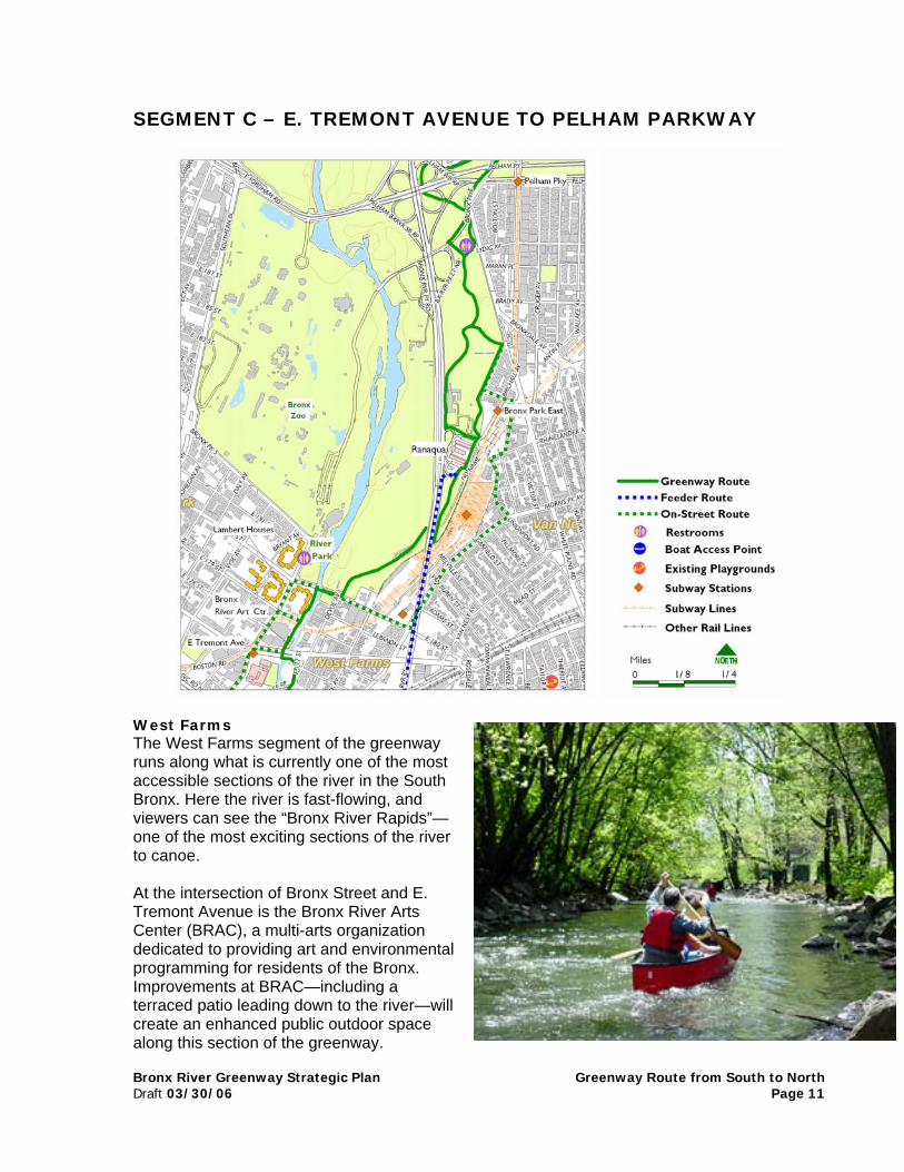
SEGMENT C – E. TREMONT AVENUE TO PELHAM PARKWAY
West Farms The West Farms segment of the greenwayruns along what is currently one of the mostaccessible sections of the river in the SouthBronx. Here the river is fast-flowing, andviewers can see the “Bronx River Rapids”—one of the most exciting sections of the riverto canoe.
At the intersection of Bronx Street and E.Tremont Avenue is the Bronx River ArtsCenter (BRAC), a multi-arts organizationdedicated to providing art and environmentalprogramming for residents of the Bronx.Improvements at BRAC—including aterraced patio leading down to the river—willcreate an enhanced public outdoor spacealong this section of the greenway.

Beyond BRAC, the greenway continues north on thewest bank of the river and utilizes the old streetbedof Bronx Street, which is now closed to motorizedvehicle traffic. Bronx Street is just one block longand terminates at E. 179th Street. From there, thegreenway will continue north along a narrow strip ofparkland behind the Lambert Houses to 180th Street.An agreement with Phipps Housing, Inc., thenonprofit owner and manager of the LambertHouses, would allow for a wider, straighter path
a
1
2
3
4
5
SEGMENT C COMPONENT PROJECTS
. BRAC improvements
. West Farms segment
. 180th Street – Birchall Avenue
. Intersection with Boston Road at theBronx Zoo
. Intersection with Pelham Parkway
Bronx River Greenway Strategic Plan Greenway Route from South to NorthDraft 03/30/06 Page 12
alignment and that allows better access into and outof this greenway segment via bicycle. This
greement would also provide improved lighting and security.
This entire section of the greenway will be reconstructed to open up sight lines andimprove safety.
At E. 180th Street, the path emerges directly opposite from River Park. River Park’s rockoutcroppings overlook the 20-foot high waterfall where the river exits the Bronx Zoo. Parksreceived $1m from the Croton mitigation funds to make improvements to River Park, includingreconstructing the playground, comfort station, and picnic area located adjacent to thegreenway. A comfort station is located in this park.
Bronx River Alliance's Annual Golden Ball Festival, passing below RiverPark
E . 180th Street to Bronx Park EastThe greenway path alignment from 180th Street to Ranaqua (Bronx Borough ParksHeadquarters) and Bronx Park East is one of the most problematic sections of the greenwayand has not yet been determined. This area’s complex topography and many layers of rail,street, and highway infrastructure create real challenges to the development of a safe andinviting route. A promising alternative would create a Class One pathway along the north side of

Bronx River Greenway Strategic Plan Greenway Route from South to NorthDraft 03/30/06 Page 13
E. 180th Street, which could connect to new pathway along between the MTA and Firehouseproperties. The path could then run along a small edge of Zoo property and underneath theBronx River Parkway. From there the path could run adjacent to Ranaqua’s vehicle storageyards. This option would involve minimal elevation change for the pathway, but rights-of-waywould have to be negotiated with the Bronx Zoo, the MTA, Parks, and potentially the NYC FireDepartment.
This route will bring the path onto the Parks property known as Ranaqua. The complex servesas the Borough Headquarters for Parks and houses administrative, operations, program offices,maintenance and repair shops, and facilities for vehicle storage and maintenance.
In recent years, traffic exiting and entering the northbound Bronx River Parkway fromRanaqua’s driveways and parking lots is a potential hazard to pedestrians and cyclists. A pathalignment can be developed that will minimize conflicts, but it may be desirable to curtail use ofthe driveways by through traffic. In fact, additional signage and barricades installed in late springof 2005 have already dramatically reduced unauthorized traffic through the Ranaqua propertyand improved safety in the complex.
An additional challenge on this segment of the greenway is determining if the path should run infront of or behind Ranaqua. Determining the best alignment involves trade-offs between greatervisibility and safety of the greenway, minimizing the number of parking spaces that need to berealigned or reduced and minimizing impact on landscaped areas.
The most likely route for the greenway will exit Ranaqua to the north along the Parksemployee parking lot. From there, the greenway will enter a forested section of BronxPark East, and connect with existing park paths, which will be improved and marked aspart of the greenway path.
Connection to Bronx Zoo River Walk / Pelham Parkway Intersection The path will then cross Boston Road, which provides access to the Bronx Zoo’s easternparking lot and entrance. A planned—but as yet unfunded—NYSDOT project is to reconfigurethe intersection of Boston Road, the Bronx River Parkway entrance and exit ramps, and PelhamParkway. The reconfiguration of this intersection would provide an opportunity to integrate thedesign of the greenway with the road and ramp system here.
A side trip off the greenway is the Bronx Zoo’s Riverwalk—a riverside park with a 4/10-mileinterpretative nature trail along the eastern shore of the Bronx River with beautiful views one ofthe Bronx River’s many waterfalls. Through a settlement with State Attorney General EliotSpitzer, the Bronx Zoo/ Wildlife Conservation Society agreed to create the Riverwalk tocompensate for the Zoo’s contribution to pollution in the river. The Riverwalk—located justbeyond the Zoo’s eastern entrance— opened in April 2004 and is free and open to the publicduring regular Bronx Zoo operating hours, providing educational and recreational opportunitiesfor local residents and other visitors.
Continuing north on the greenway, improvements are planned for the intersection ofPelham Parkway, Boston Road, and Bronx Park East. Pedestrians and cyclists are nowdirected by signs to travel to the east side of the intersection. From here, they must thenbacktrack on the north sidewalk of Pelham Parkway, and re-enter the greenway aftercrossing the access ramp between Bronx Park East and the northbound Bronx RiverParkway.

Bronx River Greenway Strategic Plan Greenway Route from South to NorthDraft 03/30/06 Page 14
Proposed Bronx River Parkway Viaduct PathNYSDOT is planning a number of major projects on the Bronx River Parkway. As a part ofimproving vehicular conditions on the Parkway, NYSDOT also plans to develop a separatedbike path on the viaduct between E. Tremont Avenue and Ranaqua. This viaduct bike pathconnection would provide direct access from the Parkchester neighborhoods to destinationsnorth on the Bronx River Greenway. In addition, proposals are currently being discussed toprovide a connection from this Bronx River Parkway bike path to E. 180th Street and the trainstation there.
On-Street GreenwaysThis segment of the Bronx River Greenway makes connections to Boston Road, E. 180th Street,Morris Park Avenue, White Plains Road, Bronxdale Avenue, Rhinelander, and Bronx ParkEast—all recommended routes listed on the 2005 New York City Cycling Map. In addition, thissegment connects to the forthcoming Bronx River Parkway Viaduct Greenway at Ranaqua andto the Mosholu-Pelham Greenway at Pelham Parkway.
The on-street detour for cyclists, pedestrians, and rollerbladers traveling from E. TremontAvenue and who wish to connect to Pelham Parkway is the following:
Turn north onto Boston Road
Right onto E. 180th Street
Left onto Morris Park Avenue
Left onto Amethyst
Left onto Sagamore (under the elevated train tracks)
Right onto Unionport
Left onto Bronx Park East to the intersection with Pelham Parkway
Segment C Outstanding Issues Major issue to be resolved is the connection from E. 180th Street through
Ranaqua, to connect to Bronx Park East. In addition, this portion of the pathwill likely be isolated and so safety and security warrant extra attention.
Greenway intersection with Boston Road and Pelham Parkway—realignmentplanned, not yet funded
Bronx River Greenway Strategic Plan Greenway Draft 03/30/06
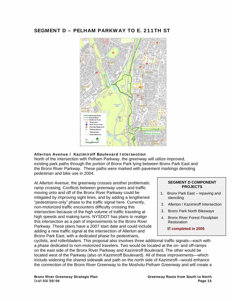
SEGMENT D – PELHAM PARKWAY TO E. 211TH ST
Allerton Avenue / Kazimiroff Boulevard IntersectionNorth of the intersection with Pelham Parkway, the greenway will utilize improved,existing park paths through the portion of Bronx Park lying between Bronx Park East andthe Bronx River Parkway. These paths were marked with pavement markings denotingpedestrian and bike use in 2004.
At Allerton Avenue, the greenway crosses another problematicramp crossing. Conflicts between greenway users and trafficmoving onto and off of the Bronx River Parkway could bemitigated by improving sight lines, and by adding a lengthened“pedestrians-only” phase to the traffic signal here. Currently,non-motorized traffic encounters difficulty crossing thisintersection because of the high volume of traffic traveling athigh speeds and making turns. NYSDOT has plans to realignthis intersection as a part of improvements to the Bronx RiverParkway. These plans have a 2007 start date and could includeadding a new traffic signal at the intersection of Allerton andBronx Park East, with a dedicated phase for pedestrians,cyclists, and rollerbladers. This proposal also involves three additional ta phase dedicated to non-motorized travelers. Two would be located at on the east side of the Bronx River Parkway and Kazimiroff Boulevard. located west of the Parkway (also on Kazimiroff Boulevard). All of theseinclude widening the shared sidewalk and path on the north side of Kazthe connection of the Bronx River Greenway to the Mosholu-Pelham Gr
1.
2.
3.
4.
SEGMENT D COMPONENTPROJECTS
Bronx Park East – repaving andstenciling
Allerton / Kazimiroff Intersection
Bronx Park North Bikeways
Bronx River Forest FloodplainRestoration
completed in 2005
Route from South to NorthPage 15
raffic signals—each withthe on- and off-rampsThe other would be improvements—whichimiroff—would enhanceeenway and will create a

Bronx River Greenway Strategic Plan Greenway Route from South to NorthDraft 03/30/06 Page 16
safe crossing for Bronx River Greenway users to continue north/south. As of early 2006,proposals and designs are still being evaluated for this intersection.
Bronx Park EastNorth of the intersection with Allerton Avenue, the main greenway path continues north and runsalong the east side of the Bronx River Parkway and the river.
Spur Loop Path Bronx Park North Bikeways: French Charley, Allerton / McCarthy-Cunnion-Hourigan BallFieldsAlthough this is not the main section of the greenway, the path—in making theconnection to the Mosholu Greenway to the west—makes a loop between Allerton andBurke Avenues. After traveling west along Kazimiroff Boulevard but before the BotanicalGardens Metro North station, the path makes a sharp turn north and enters a popularpark with several ballfields, a comfort station, and a playground. The area around theballfields has many colorful names, including the French Charley playground, namedafter Charley Mangin who owned a nearby French restaurant in the 1890s. Hisestablishment, in the heart of a small French enclave of the Bronx, was popularlyreferred to as French Charley’s. The ballfields in the area are frequently referred to asthe Allerton ballfields. However, the true name of these athletic fields is the McCarthy-Cunnion-Hourigan fields, named after three Vietnam veterans who were killed in action.In addition, the section of the greenway path that runs along Kazimiroff Boulevard, theballfields, and playground is referred to as “Bronx Park North Bikeways” by Parks, and isscheduled to be repaved and striped in 2006.
Bronx River ForestBeyond French Charley, the path enters the Bronx River Forest, where a $3 millionfloodplain restoration project was begun in 2004 and completed in June 2005. The pathhere follows the old roadbed of the Bronx River Parkway to Burke Bridge—a newly-renovated scenic look-outcomplete with new signage,bollards, and benches. Thegreenway path in this area hasbeen reduced significantly, fromthe 40-foot wide roadbed of theformer parkway, to the 16-footwidth required to servepedestrians and bicyclists. Themain greenway path will notenter the restored area, whereinvasive plants species havebeen replaced with natives andthe floodplain has been restored.Pedestrian paths andboardwalks from the BurkeBridge, however, provide accessalong the waterfront, and forth-coming interpretive signs willexplain how the restored forest contributes to the health of the river. Leaving the Bronx River
Bank stabilization work visible in the Bronx River Forest
Bronx River Greenway Strategic Plan Greenway Route from South to NorthDraft 03/30/06 Page 17
Main Greenway Path, Burke Avenue to Gun Hill RoadThe main greenway route continues north from Burke Avenue along improved park paths toMagenta Street. From Magenta to East 211th Street, the greenway will utilize one lane of BronxBoulevard, another segment of the original Bronx River Parkway, where the roadway width willbe narrowed. As the greenway passes under the brick-arched viaduct of Gun Hill Road, anarrow pathway at the river level can be accessed from a stairway at Duncomb Avenue in thecenter of Bronx Boulevard. This soft path allows users to enjoy the Duncomb bridge arches,reflected in the slow-moving river and also connects back to the pedestrian paths in the BronxRiver Forest.
On-Street GreenwaysThis segment of the Bronx River Greenway makes connections to Allerton Avenue, BurkeAvenue, and Webster Avenue—all recommended routes listed on the 2005 New York CityCycling Map. (However, please note that Mace Avenue may be preferable to biking on the verybusy Allerton Avenue). In addition, at Pelham Parkway, the Bronx River Greenway connects tothe Mosholu-Pelham Greenway.
Cyclists, rollerbladers, and pedestrians will likely feel fairly safe on this segment of thegreenway, due to its close proximity to street activity. However, in the case that they donot or need to travel to a destination not directly along the greenway, we recommendthat they travel on Bronx Park East—a wide and sparsely-traveled road—even though itis not listed as a recommended route on the NYC Cycling Map.
Segment D Outstanding Issues Resolve conflicts at the intersection with
Allerton/Kazimiroff Avenue
Bronx River Greenway Strategic Plan GreenwayDraft 03/30/06
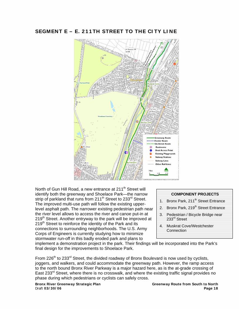
SEGMENT E – E. 211TH STREET TO THE CITY LINE
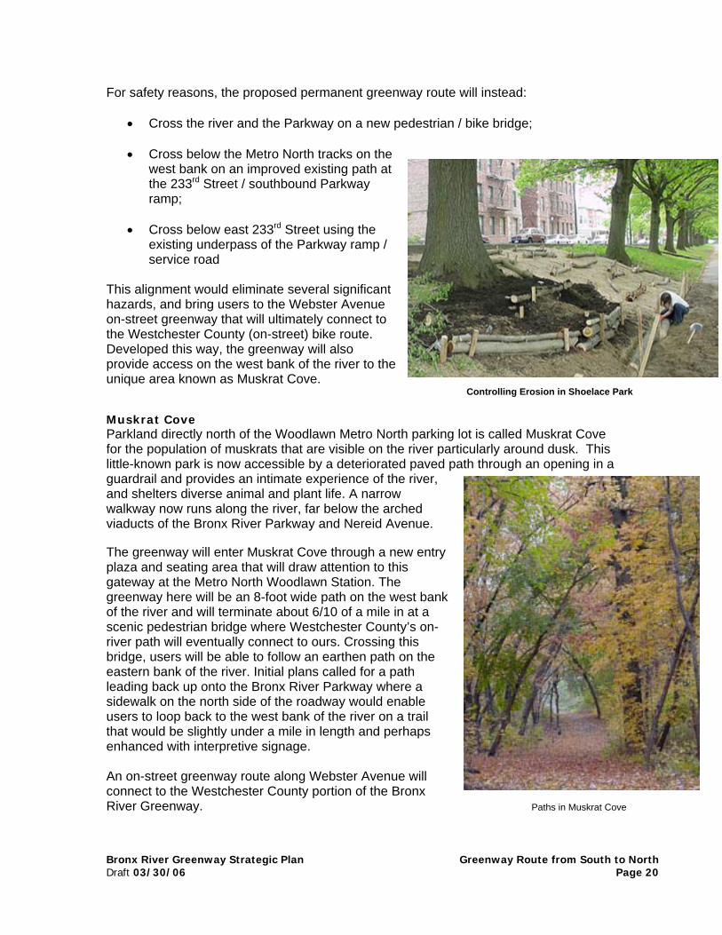
North of Gun Hill Road, a new entrance at 211th Street willidentify both the greenway and Shoelace Park—the narrowstrip of parkland that runs from 211th Street to 233rd Street.The improved multi-use path will follow the existing upper-level asphalt path. The narrower existing pedestrian path nearthe river level allows to access the river and canoe put-in at219th Street. Another entryway to the park will be improved at219th Street to reinforce the identity of the Park and itsconnections to surrounding neighborhoods. The U.S. ArmyCorps of Engineers is currently studying how to minimizestormwater run-off in this badly eroded park and plans toimplement a demonstration project in the park. Their findings will be incfinal design for the improvements to Shoelace Park.
From 226th to 233rd Street, the divided roadway of Bronx Boulevard is njoggers, and walkers, and could accommodate the greenway path. Howto the north bound Bronx River Parkway is a major hazard here, as is thEast 233rd Street, where there is no crosswalk, and where the existing tphase during which pedestrians or cyclists can safely cross.
1. Br
2. Br
3. Pe23
4. MCo
COMPONENT PROJECTS
onx Park, 211th Street Entrance
onx Park, 219th Street Entrance
destrian / Bicycle Bridge near3rd Street
uskrat Cove/Westchesternnection
Route from South to NorthPage 18
orporated into the Park’s
ow used by cyclists,ever, the ramp accesse at-grade crossing ofraffic signal provides no
Bronx River Greenway Strategic Plan Greenway Route from South to NorthDraft 03/30/06 Page 20
For safety reasons, the proposed permanent greenway route will instead:
• Cross the river and the Parkway on a new pedestrian / bike bridge;
• Cross below the Metro North tracks on thewest bank on an improved existing path atthe 233rd Street / southbound Parkwayramp;
• Cross below east 233rd Street using theexisting underpass of the Parkway ramp /service road
This alignment would eliminate several significanthazards, and bring users to the Webster Avenueon-street greenway that will ultimately connect tothe Westchester County (on-street) bike route.Developed this way, the greenway will alsoprovide access on the west bank of the river to theunique area known as Muskrat Cove.
Controlling Erosion in Shoelace Park
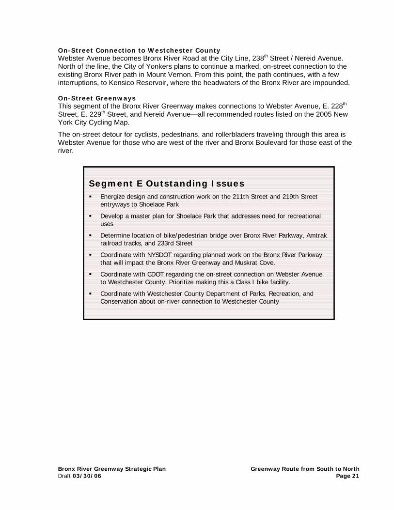
Muskrat CoveParkland directly north of the Woodlawn Metro North parking lot is called Muskrat Covefor the population of muskrats that are visible on the river particularly around dusk. Thislittle-known park is now accessible by a deteriorated paved path through an opening in aguardrail and provides an intimate experience of the river,and shelters diverse animal and plant life. A narrowwalkway now runs along the river, far below the archedviaducts of the Bronx River Parkway and Nereid Avenue.
The greenway will enter Muskrat Cove through a new entryplaza and seating area that will draw attention to thisgateway at the Metro North Woodlawn Station. Thegreenway here will be an 8-foot wide path on the west bankof the river and will terminate about 6/10 of a mile in at ascenic pedestrian bridge where Westchester County’s on-river path will eventually connect to ours. Crossing thisbridge, users will be able to follow an earthen path on theeastern bank of the river. Initial plans called for a pathleading back up onto the Bronx River Parkway where asidewalk on the north side of the roadway would enableusers to loop back to the west bank of the river on a trailthat would be slightly under a mile in length and perhapsenhanced with interpretive signage.
An on-street greenway route along Webster Avenue willconnect to the Westchester County portion of the BronxRiver Greenway. Paths in Muskrat Cove
Bronx River Greenway Strategic Plan Greenway Route from South to NorthDraft 03/30/06 Page 21
On-Street Connection to Westchester CountyWebster Avenue becomes Bronx River Road at the City Line, 238th Street / Nereid Avenue.North of the line, the City of Yonkers plans to continue a marked, on-street connection to theexisting Bronx River path in Mount Vernon. From this point, the path continues, with a fewinterruptions, to Kensico Reservoir, where the headwaters of the Bronx River are impounded.
On-Street GreenwaysThis segment of the Bronx River Greenway makes connections to Webster Avenue, E. 228th
Street, E. 229th Street, and Nereid Avenue—all recommended routes listed on the 2005 NewYork City Cycling Map.
The on-street detour for cyclists, pedestrians, and rollerbladers traveling through this area isWebster Avenue for those who are west of the river and Bronx Boulevard for those east of theriver.
Segment E Outstanding Issues Energize design and construction work on the 211th Street and 219th Street
entryways to Shoelace Park
Develop a master plan for Shoelace Park that addresses need for recreationaluses
Determine location of bike/pedestrian bridge over Bronx River Parkway, Amtrakrailroad tracks, and 233rd Street
Coordinate with NYSDOT regarding planned work on the Bronx River Parkwaythat will impact the Bronx River Greenway and Muskrat Cove.
Coordinate with CDOT regarding the on-street connection on Webster Avenueto Westchester County. Prioritize making this a Class I bike facility.
Coordinate with Westchester County Department of Parks, Recreation, andConservation about on-river connection to Westchester County