Embed Size (px)
Citation preview
Chapter 2 Geographical Profile of the
Study Area
Chapter 2: Geographical Profile of the Study Area
23
CHAPTER -2
GEOGRAPHICAL PROFILE OF THE STUDY AREA
2.1 AGRA
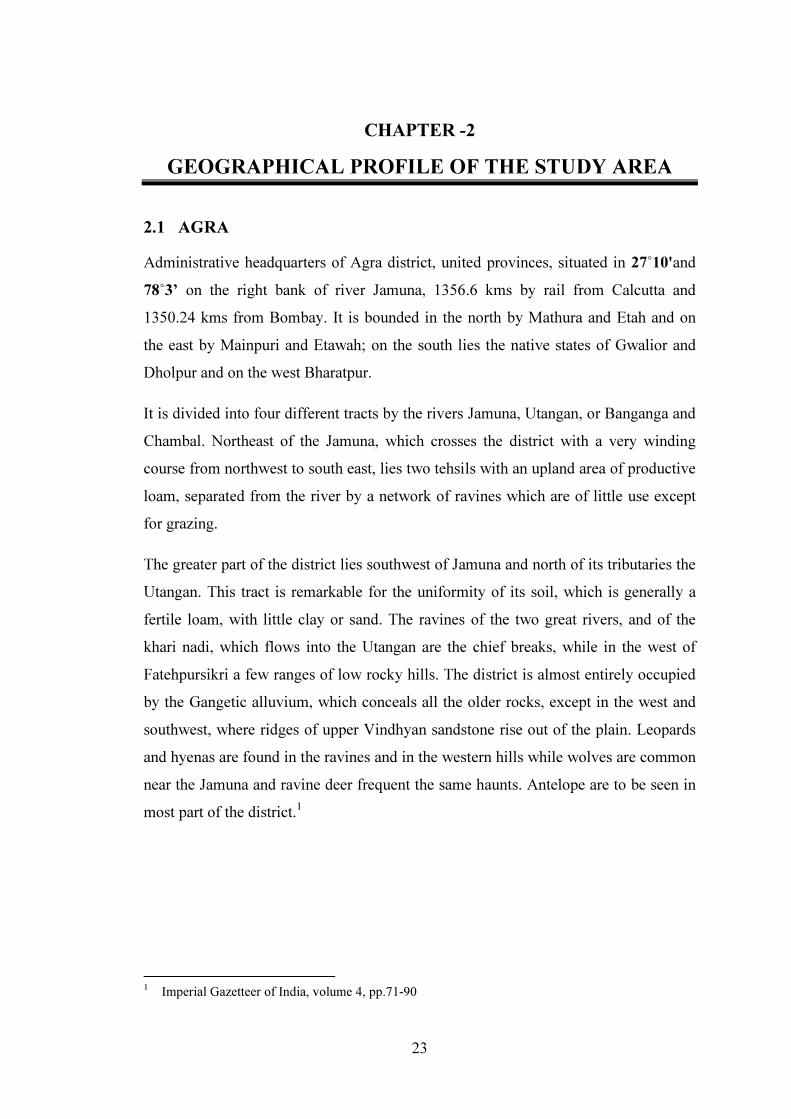
Administrative headquarters of Agra district, united provinces, situated in 27˚10'and 78˚3’ on the right bank of river Jamuna, 1356.6 kms by rail from Calcutta and 1350.24 kms from Bombay. It is bounded in the north by Mathura and Etah and on the east by Mainpuri and Etawah; on the south lies the native states of Gwalior and Dholpur and on the west Bharatpur.
It is divided into four different tracts by the rivers Jamuna, Utangan, or Banganga and Chambal. Northeast of the Jamuna, which crosses the district with a very winding course from northwest to south east, lies two tehsils with an upland area of productive loam, separated from the river by a network of ravines which are of little use except for grazing.
The greater part of the district lies southwest of Jamuna and north of its tributaries the Utangan. This tract is remarkable for the uniformity of its soil, which is generally a fertile loam, with little clay or sand. The ravines of the two great rivers, and of the khari nadi, which flows into the Utangan are the chief breaks, while in the west of Fatehpursikri a few ranges of low rocky hills. The district is almost entirely occupied by the Gangetic alluvium, which conceals all the older rocks, except in the west and southwest, where ridges of upper Vindhyan sandstone rise out of the plain. Leopards and hyenas are found in the ravines and in the western hills while wolves are common near the Jamuna and ravine deer frequent the same haunts. Antelope are to be seen in most part of the district.1
1 Imperial Gazetteer of India, volume 4, pp.71-90
Chapter 2: Geographical Profile of the Study Area
24
ASource: An Atlas of the Mughal Empire
Map 2.1: Divisions of Agra in 1595
AGRA
DIVISIONS OF AGRA IN MUGHAL ERA 1595
Chapter 2: Geographical Profile of the Study Area
25
2.2 AHMEDABAD
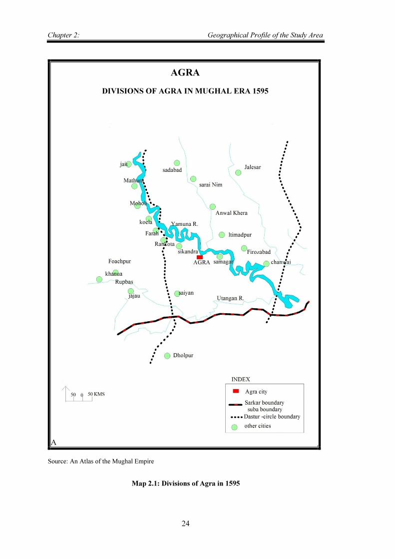
It is situated in 23˚2'N and 72˚35'E, 310 miles by rail from Bombay, and about 80 kms N of the head of the Gulf of The Cambay. The general appearance of the district shows that at no very remote period it was covered with sea. The tract between the head of the Gulf of Cambay and the Rann of Kutch is still subject to overflow at high tides. In the extreme south, and also just beyond, are a few rocky hills.
But between these points the hole of the district forms very level plains, gradually rising towards the north and east, its surface unbroken by any inequality greater than a sand hill. The chief physical features is the river Sabarmati which rises in the northeast, near the extremity of the Aravali range, and flows towards the south west, falling finally into the Gulf of Cambay.
The river has three tributaries; the khari, meshwa, and majham all flow southwest. The district is occupied mostly by alluvial plains. The superficial covering of Alluvium is, however of no great thickness. The underline strata probably include tertiary and cretaceous sediments, resting on a sub stratum of gneiss and possibly slate.
The district as a whole is open and poorly wooded. The chief trees are Mango, Rayan (mimusops hexandra), Mahua and Neem. Tigers are almost extinct. Leopards are found in modasa, and wolves in the low lying salt lands near the nal. Wild hog are common.2
2 Ibid. Vol. 4, pp.93-110
Chapter 2:
Source: An Atlas of Mughal Empire
Map 2.2: Divisions of Ahmedabad in Mughal Era 1595
DIVISIONS OF AHMEDABAD IN MUGHAL ERA 1595
Geographical Profile of the
26
Source: An Atlas of Mughal Empire
: Divisions of Ahmedabad in Mughal Era 1595
AHMEDABAD
DIVISIONS OF AHMEDABAD IN MUGHAL ERA 1595
of the Study Area
: Divisions of Ahmedabad in Mughal Era 1595
Chapter 2: Geographical Profile of the Study Area
27
2.3 BANARAS/VARANASI
Headquarters of Banaras district united provinces with cantonment is situated in 25˚ 18'N and 83˚1'E on the left bank of Ganges; distant by rail from Calcutta 770 km, and from Bombay 1514 km. The city is the second largest in the united provinces. The district is part of the alluvial valley deposited by the river Ganges, and its forms an irregular parallelogram, divided by the sacred streams.
On each bank of the river is found a high ridge of coarse gravelly soil, mixed with kankar or nodular limestone and scored by ravines. East of the Ganges the surface dipped rapidly, and a large portion of this tract is under water during the rains, and it’s generally marshy. On the opposite bank the level is more uniformly maintained. The Ganges first touches the district on the southern boundaries, and after crossing it in a series of bold curves.
With general directions from southwest to north east, leaves the northern border, at the point there it receives the Gomti, which forms the northern boundaries for about 35.4 km. The district contains many small marshy lakes or jhils, some of which attain a length of several miles during the rains, but most of them are almost dry in the summer.
Banaras lies entirely in the Gangetic alluvium, and kankar is the only stones found, saline efflorescence called Reh are not uncommon, especially in the chandauli tehsil. The flora of the district presents no peculiarities.
The mango and bamboos are largely planted, and fine groves are numerous. Fruit is also largely grown, and Banaras is famous for its mangoes and guavas. Owing to the absence of uncultivated land, the wild animals found here are not important. A few antelope are seen northeast of the Ganges; wild fowl congregate in numbers on the river.3
3 Imperial Gazetteer of India, vol. 7,pp. 1-13
Chapter 2: Geographical Profile of the Study Area
28
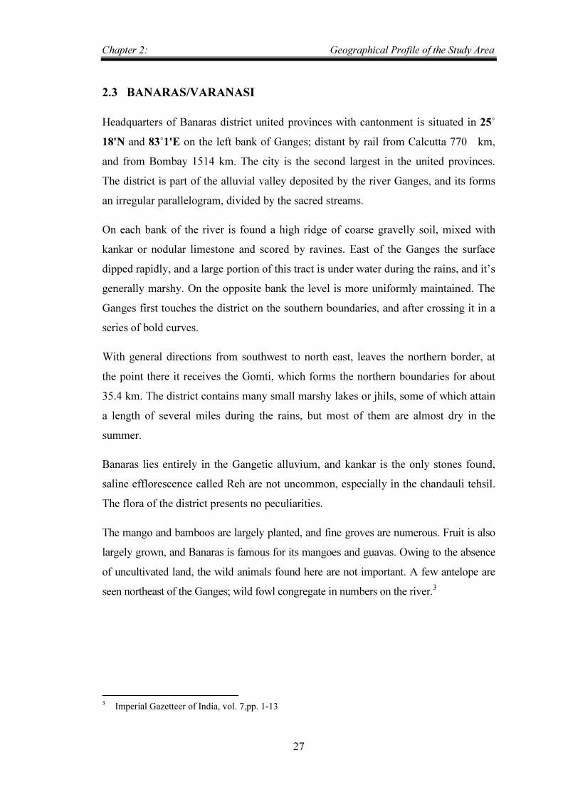
Source: An Atlas of the Mughal Empire
Map 2.3: Divisions of Banaras in Mughal Era 1595
BANARAS
DIVISIONS OF BANARAS IN MUGHAL ERA 1595
Chapter 2: Geographical Profile of the Study Area
29
2.4 CAMBAY/KHAMBAT
Feudatory state in the political Agencies of Kaira, Bombay, lying at the head of the gulf of the same name in the western part of the province of Gujarat, between 22˚9' and 22˚41' N, and 72˚ 20' and 73˚5' E, with an area of 563 kms square miles.
It is bounded on the north by the District of Kaira; on the east by Kaira and Baroda; on the south by the Gulf of Cambay and on the west by the Sabarmati River separating it from Ahmedabad. The boundaries of the State are very irregular; some villages belonging to the Gaikwar of Baroda and to the British Government are entirely surrounded by Cambay territory, while Cambay villages are found in the Kaira District.
The country is flat and open, interspersed here and there, generally in the vicinity of the villages with groves of fine trees, such as the mango, tamarind, banyan or bar, neem and papal. From the position of the state between the Sabarmati and Mahi, both of which are tidal rivers, the soil is so soaked with salt that the water becomes brakish at a little distance below the surface.
Cambay is a gentle, undulating, alluvial, and plain without any rock exposure. The fauna does not differ from that of the neighbouring British District of Kaira, through the former presence of tigers in large number is said to be indicated by the site of a village named Vagh Talao or Tiger tank. The climate is equable, the temperature rising to 108˚ in May, when minimum is 75˚, and falling as low as 46˚ in January, at which seasons 84˚ is the maximum. The annual rainfall averages 31 inches.4
4 Imperial Gazetteer of India , vol. 9, pp292-298
Chapter 2:
Source: An Atlas of the Mughal Empire
Map 2.4
DIVISIONS OF CAMBAY IN MUGHAL ERA 1595
Geographical Profile of the
30
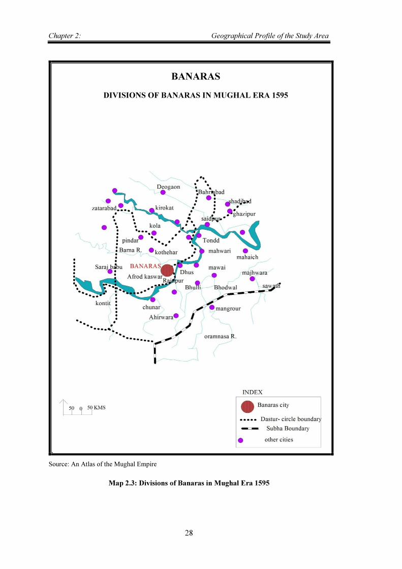
Source: An Atlas of the Mughal Empire
Map 2.4: Division of Cambay in Mughal Era 1595
CAMBAY
DIVISIONS OF CAMBAY IN MUGHAL ERA 1595
of the Study Area
: Division of Cambay in Mughal Era 1595
Chapter 2: Geographical Profile of the Study Area
31
2.5 DELHI
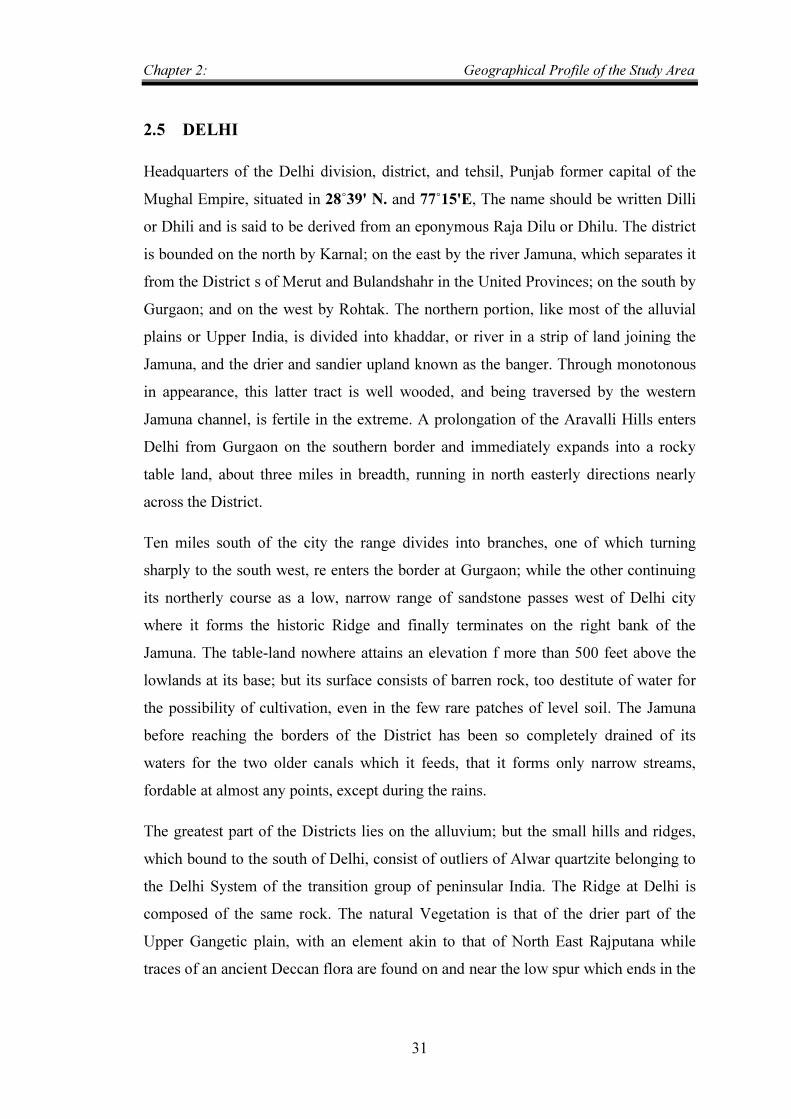
Headquarters of the Delhi division, district, and tehsil, Punjab former capital of the Mughal Empire, situated in 28˚39' N. and 77˚15'E, The name should be written Dilli or Dhili and is said to be derived from an eponymous Raja Dilu or Dhilu. The district is bounded on the north by Karnal; on the east by the river Jamuna, which separates it from the District s of Merut and Bulandshahr in the United Provinces; on the south by Gurgaon; and on the west by Rohtak. The northern portion, like most of the alluvial plains or Upper India, is divided into khaddar, or river in a strip of land joining the Jamuna, and the drier and sandier upland known as the banger. Through monotonous in appearance, this latter tract is well wooded, and being traversed by the western Jamuna channel, is fertile in the extreme. A prolongation of the Aravalli Hills enters Delhi from Gurgaon on the southern border and immediately expands into a rocky table land, about three miles in breadth, running in north easterly directions nearly across the District.
Ten miles south of the city the range divides into branches, one of which turning sharply to the south west, re enters the border at Gurgaon; while the other continuing its northerly course as a low, narrow range of sandstone passes west of Delhi city where it forms the historic Ridge and finally terminates on the right bank of the Jamuna. The table-land nowhere attains an elevation f more than 500 feet above the lowlands at its base; but its surface consists of barren rock, too destitute of water for the possibility of cultivation, even in the few rare patches of level soil. The Jamuna before reaching the borders of the District has been so completely drained of its waters for the two older canals which it feeds, that it forms only narrow streams, fordable at almost any points, except during the rains.
The greatest part of the Districts lies on the alluvium; but the small hills and ridges, which bound to the south of Delhi, consist of outliers of Alwar quartzite belonging to the Delhi System of the transition group of peninsular India. The Ridge at Delhi is composed of the same rock. The natural Vegetation is that of the drier part of the Upper Gangetic plain, with an element akin to that of North East Rajputana while traces of an ancient Deccan flora are found on and near the low spur which ends in the
Chapter 2: Geographical Profile of the Study Area
32
ridge at Delhi. The Mango and other sub tropical species are cultivated in gardens and along canals and road sides; but large trees, except where planted are comparatively scarce and the kinds that reproduce themselves spontaneously are probably in most cases, not native of the District. Wolves are not uncommon and leopards are occasionally met with. Hog are painful all along the Jamuna. Antelope are becoming scarce while Nilgai and hog deer are practically extinct. Ravine deer (Indian Gazelle) are found in the low hills.
The cold season is much like that of the Punjab; proper but ends a fortnight sooner than at Lahore. Hot west winds blow steadily till the end of June, when plentiful rain is expected. October brings cool night and the beginning of the feverish seasons, which is always very unhealthy. The average mean temperature of January is 57˚, of April 85˚, of June 97˚ and of September 87˚.
The annual rainfall varies from 21 ½ inches at Ballabgarh to 28 at Delhi. Of the rainfall at the latter place 25 inches fall in the summer month and 3 in winter. The greatest rainfall recorded during the twenty years ending 1901 was 48 inches at Delhi in 1884-85 and the least one fifth of an inch at mahrauli in 1896-7.5
5 Ibid, vol. 12, pp. 223-238
Chapter 2: Geographical Profile of the Study Area
33
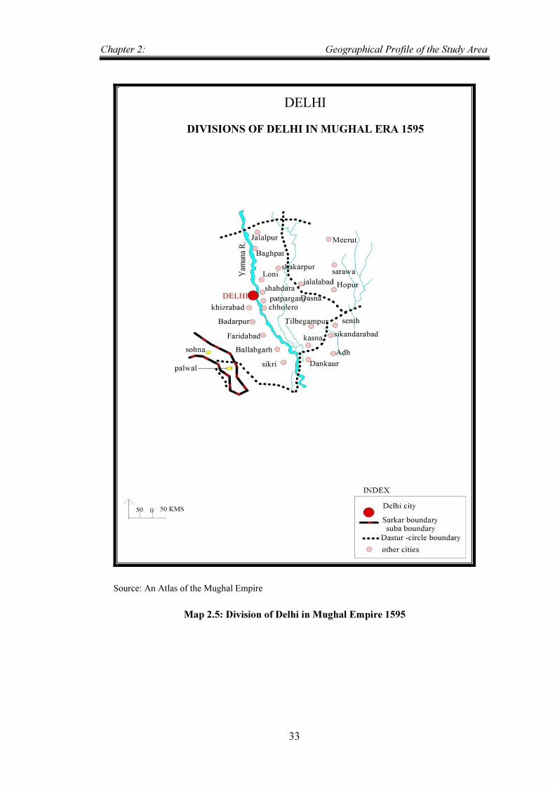
Source: An Atlas of the Mughal Empire
Map 2.5: Division of Delhi in Mughal Empire 1595
DELHI
DIVISIONS OF DELHI IN MUGHAL ERA 1595
Chapter 2: Geographical Profile of the Study Area
34
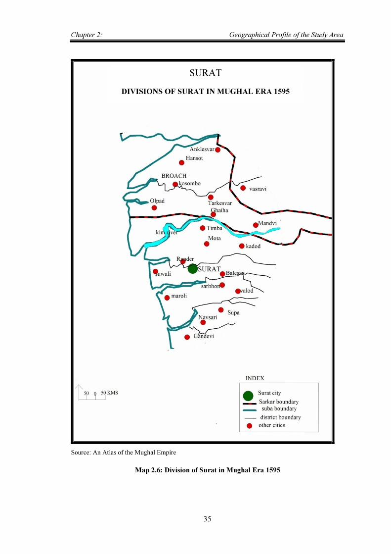
2.6 SURAT
It is situated on the perennial river of river Tapti and is a famous port city of Gujarat; the city is located at 21.17˚N, 72.83˚E and has an average elevation of 13 mts. The climate is tropical and monsoon is abundant.
The city is famous for diamond cutting. The mangoes of some Surat gardens approach the Bombay ‘Alphonso’ and ‘pairi’ in flavour and sweetness. There are no good timber trees. The Babul is found in small bushes in most part of the district springing up freely in fields set apart for the cultivation of grass Wild flowering plant are not numerous, the commonest being Hibiscus, Abutilon, Sida, Clerodendron, Phlomis, Salvadora, Celosia, and Leuca..
The fauna of Surat includes a few tigers, stragglers from the jungles of Bansda, and Dharampur, beside Leopards (which are found throughout the district) bears wild hog, wolves, hyenas, spotted deer, and antelope. Other and grey foxes are also met with. Duck, wild geese, teal, and other wild-fowl abound during the cold seasons on the ponds and reservoirs; and hares, partridges, and quail are common.6
6 Ibid, vol. 23, pp. 150-164
Chapter 2: Geographical Profile of the Study Area
35
Source: An Atlas of the Mughal Empire
Map 2.6: Division of Surat in Mughal Era 1595
SURAT
DIVISIONS OF SURAT IN MUGHAL ERA 1595