Embed Size (px)
Citation preview
29
CHAPTER - 2
GEO-STRATEGIC AND SOCIO-ECONOMIC
ENVIRONMENT OF NORTH EAST INDIA:
HISTORICAL BACKGROUND
30
CHAPTER - 2
GEO-STRATEGIC AND SOCIO-ECONOMIC ENVIRONMENT
OF NORTH EAST INDIA: HISTORICAL BACKGROUND
Introduction-
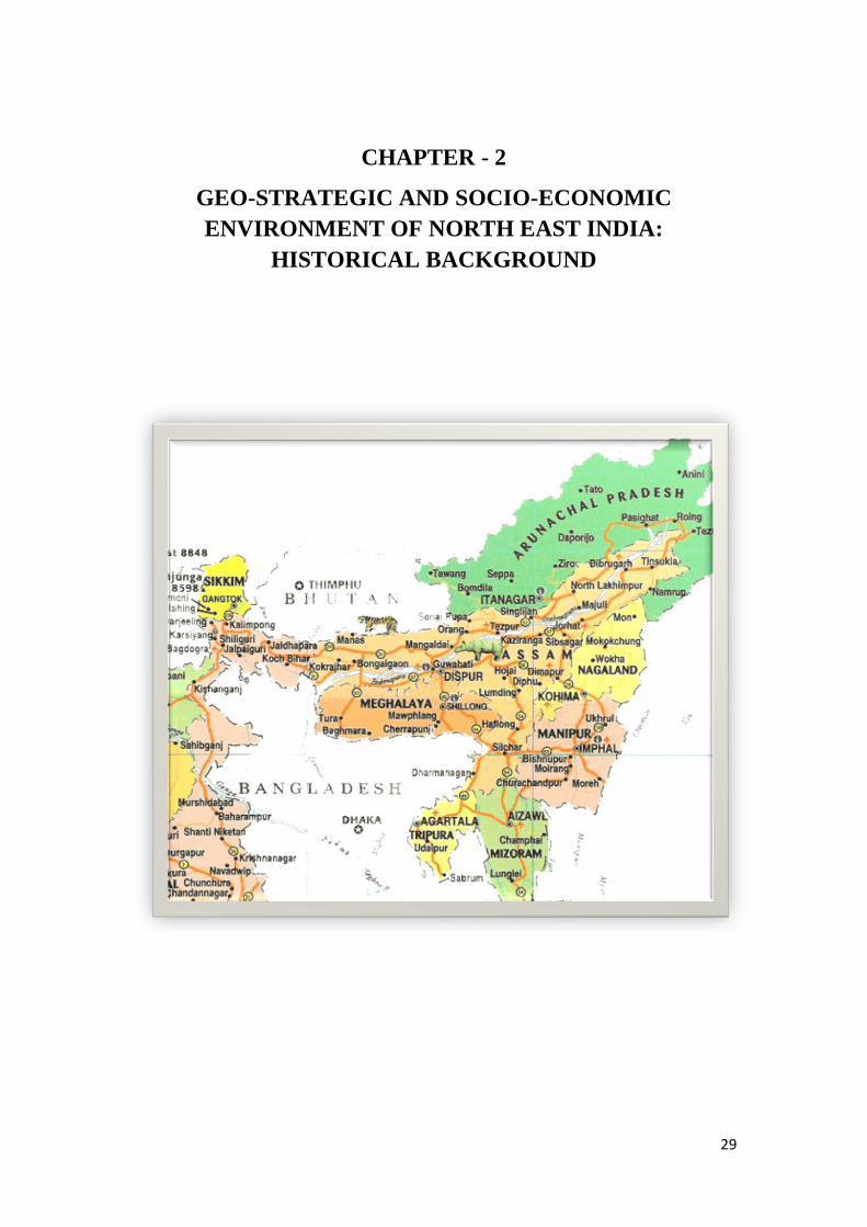
The north eastern region of India shares borders with Bhutan, Nepal and
China on its north, Myanmar on its east and Bangladesh on its south and west that
constitutes approximately 60% of India‘s land borders. It is the only region in
south Asia to be surrounded by five countries. The jungles of south East Asia
sweep down from Bhutan and Arunachal Pradesh across seven other nations –
Bangladesh, Myanmar, Thailand, Laos, Indonesia, Malaysia and Vietnam-
spanning political boundaries regardless of physical frontiers. The region provides
access for China to the Bay of Bengal and the Indian Ocean. Lhasa is 1200 Km
from Kolkata port and Kunming is 550 Km from Sittwe port in Myanmar. Nepal is
dependent on Kolkata port for all its trade. Similarly Bhutan‘s economy is linked
to India through Assam and West Bengal. Myanmar is a gateway for India to
South East Asia through this region and Bangladesh is a prominent wedge
between Indian mainland and its north eastern states. Each one of these countries
is in a state of influx and economic turmoil, constrained by legitimacy issues.
There are political, economic and boundary grievances as a fallout of ‗small- big
power‘ syndrome. They are providing sanctuaries to the Indian insurgent groups
from the North eastern region. Fake Indian currency notes (FICN) in large
quantity is finding their way into the north east from the neighboring countries.
The region has an area of 2.6 lakh sq.km (8.06% of India‘s land area)1
while its population is 39 million plus (3.73 % of India‘s population).2 It has
estimated 483 ethnic tribes with a comparable number of languages and dialects.3
The region has immense geo – strategic importance and the ongoing insurgencies
and the implementation of the Look East policy is a matter of grave concern to the
government and the strategic planners of the country.
Ethnic coalitions, oral traditions and lifestyles based on respect for nature
1 Ministry of Development of North Eastern Region, Annual Report - 2008-09.
2 Office of the Registrar General, India, Census of India, 2001.
3 T.T. Haokip, ―North East India, Linguistic Diversity and Language Politics,‖ IDSA Occasional
Paper, No. 5, November 2009.
31
have mattered more in these regions than frontiers. Here men and women, with
common origins but different nationalities, share a racial, historic, anthropological
and linguistic kinship with each other that is more vital than their links with the
mainstream political centers, especially at Delhi, Dhaka and Yangon.
Geo- Strategic Environment of the North Eastern Region -
Bangladesh -
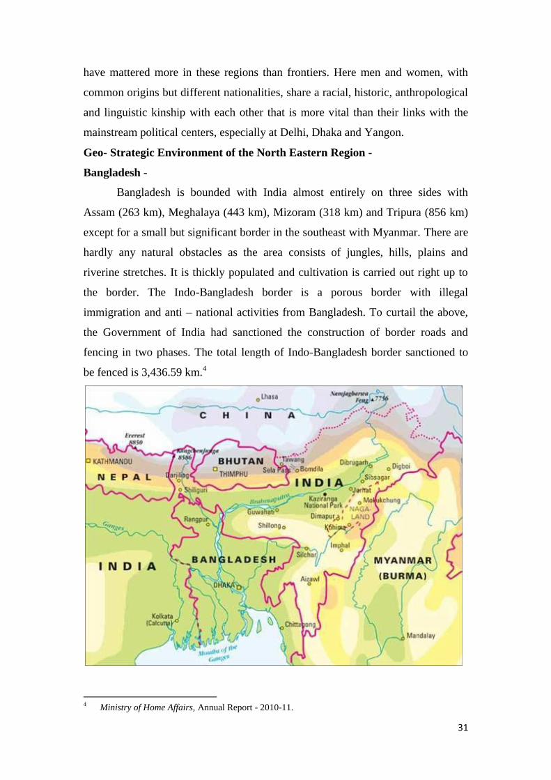
Bangladesh is bounded with India almost entirely on three sides with
Assam (263 km), Meghalaya (443 km), Mizoram (318 km) and Tripura (856 km)
except for a small but significant border in the southeast with Myanmar. There are
hardly any natural obstacles as the area consists of jungles, hills, plains and
riverine stretches. It is thickly populated and cultivation is carried out right up to
the border. The Indo-Bangladesh border is a porous border with illegal
immigration and anti – national activities from Bangladesh. To curtail the above,
the Government of India had sanctioned the construction of border roads and
fencing in two phases. The total length of Indo-Bangladesh border sanctioned to
be fenced is 3,436.59 km.4
4 Ministry of Home Affairs, Annual Report - 2010-11.
32
This border is contiguous with Myanmar state of Rakhine (old Arakan),
thus gains importance. Its geo-strategic location is of significant value to the two
strategic rivals, China and India, because in the north, Bangladesh is separated
from the Himalayan Kingdom‘s of Nepal and Bhutan by a strip of India‘s territory,
which is known as the Siliguri corridor.5 The Siliguri corridor (narrowest is 21
km) is regarded as a very sensitive strategic land for India. If this land connection
is blocked in future by any internal or external elements, India would find itself
cut off from its strategic part of the north east states, so in that situation the only
alternative way for India to reach its important part of land is a strategic corridor
through Bangladesh.
China enjoys access to the Bay of Bengal through Myanmar. Bangladesh‘s
proposal to connect it with Kunming by a road through Myanmar could be an
alternative route for China. India‘s geo-strategic location is also important for
Bangladesh because its energy security strategy relies on the import of hydro-
based electricity from Bhutan or Nepal, so Bangladesh also needs a route for
access through India.
Successive governments in Bangladesh except Awami League were
reluctant to help north east India get access to the Bay of Bengal through
Chittagong port as well as by allowing transit. However, after Sheikh Hasina came
to power Bangladesh has also agreed to use their territory for transportation of
goods on specific purposes. Bangladesh foreign minister Dipu Moni also indicated
that Dhaka would welcome Indian support for Chittagong port development where
China is also bidding. With a growing Islamist agenda, the erstwhile East Pakistan
(now Bangladesh) had emerged as the primary staging ground for the Inter Service
Intelligence (ISI) of Pakistan and Directorate General of Forces Intelligence
(DGFI) of Bangladesh operations in the north east. The erstwhile East Pakistan
was aiding the Mizo and the Naga separatists before 1971. The DGFI, as is well
known, is a smaller prototype of the ISI and was created in 1978 by General Zia-
ur-Rahman, and presently it is this organisation that has taken the initiative to
launch forward intelligence capabilities in India‘s north east.
After the assassination of Sheikh Mujibir Rehman in 1975, there had been 5 Sakhawat Hussein, ―Geo – Strategic Importance of Bangladesh‖, at
http://www.fairbd.net/Files/Geo.doc
33
a transparent shift of the foreign policy of Bangladesh towards China. Bangladesh
has been acquiring their defence and development needs from China. In 2002,
both the countries had signed an agreement on defence cooperation which covers
military training and defence production. The Bangladesh armed forces are
equipped with tanks, frigates, missile boats and fighter jets from China.
Migration from the erstwhile East Bengal/ East Pakistan and the present
day Bangladesh to eastern and north eastern parts of India has been an ongoing
phenomenon.6 Only after the partition of India in 1947, following which the
political boundaries changed has this age –old tradition become ―illegal‖. This
cross- border movement of people is due to a number of interrelated factors:
economic, environmental, religious and political. Bangladesh is one of the most
populous and poorest countries in the world thus it is a major source of labour, but
mainly of low skilled and unskilled workers. Assam was the main focus of this
immigration in the north east because of tea, oil and coal industries and the
demand for labour. However, from Assam the immigrants are now going to other
states of the region to include Nagaland, along with Mizoram, Tripura, Arunachal
Pradesh and Manipur. Mizoram is the worst affected as it has migration from
Bangladesh and Myanmar which has resulted in becoming a serious issue.
Demographic transformation has been the result of the influx from across the
border leading to tribal insurgency in the states.
With the Sheikh Hasina government in power in Bangladesh, India‘s
relations with that country seem set to improve. Bangladesh lies contiguous to
India‘s sensitive North east, which has been the focus of destabilization through
anti – Indian insurgencies supported by China, Myanmar and also Bangladesh,
singly and jointly with Pakistan. However, the security related issues need to be
addressed. The issues include the safe havens provided to the Indian insurgent
groups like the United Liberation Front of Assam (ULFA), activities of the Islamic
Groups such as the Muslim Liberation Tigers of Assam (MULTA) and the People
United Liberation Front (PULF), passage of arms and ammunition through and
from Bangladesh.
The visit of the Bangladesh Prime Minister from10-13 January 2010 6 Mansi Mehrotra, ―Illegal Immigration in India‘s North East: Perennial Problem‖, Article No 1354,
2 July 2009, Centre for Land Warfare Studies, at www.claws.org.
34
promised to launch a new phase in the ties between the two countries. Three
agreements were signed to fight against international terrorism, organized crime
and illegal drug trafficking, mutual legal assistance in criminal matters and mutual
transfer of convicted prisoners. If despite internal resistance from anti – Indian
elements and the bureaucracy, India – Bangladesh relations can be steadily
transformed, it will considerably improve the political and economic dynamics of
the region. Bangladesh can play a positive part in linking the eastern region of
south Asia to Myanmar, Thailand and beyond. A solution however has to be
found, to the problem of illegal Bangladesh migration into India.7 The Prime
Minister of India was on a two day visit to Bangladesh from 06-07 September
2011, during which many agreements less the Teesta River were signed. The
boundary issues to include the 111 Indian Enclaves (17,158 acres) and 51
Bangladesh Enclaves (7,110 acres) were agreed upon.8
Water has been a major issue in India-Bangladesh relations. There are 54
shared rivers between India and Bangladesh. The two have till date signed only the
Ganges water treaty in 1997. While the treaty has helped the two countries to
arrive at a mutually acceptable solution on the sharing of the water of the Ganges;
Bangladesh remains apprehensive about India‘s intentions on several other water-
related issues such as the sharing of the Teesta and India‘s proposal on the
interlinking of the rivers.9
Myanmar -
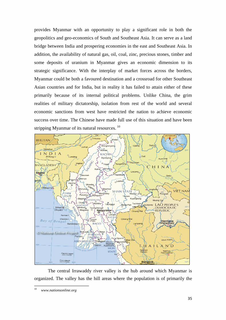
Myanmar has a land border with India (1645 km) and Bangladesh. Four
Indian states (Arunachal Pradesh, Manipur, Mizoram and Nagaland) border
Myanmar (Kachin & Chin states and Sagaing Division). Myanmar is often
perceived to be a buffer state between the two Asian giants of India and China and
also a connecting nation for India and other Southeast Asian nations. Myanmar is
geographically, dominating the Bay of Bengal and the Andaman Sea and this is
where the spheres of influence of India and China overlap. Its strategic location
7 B Raman, ―India and Bangladesh- Security related issues‖, Paper No 3652, 06 Feb 2010, at
www.southasiaanalysis.org/%5Cpapers37%5Cpaper3652.html 8 Dipanjan Roy Chaudhary,‖India, Bangladesh Settle Boundary Dispute, September 7, 2011,
at indiatoday.intoday.in/story/india-bangladesh-settle.../150380.html 9 Sayantanee Choudhary,‖Teesta: Nourishing Neighbourhood‖ Look East, Volume 1, Issue 6,
September 2010, Kolkota.
35
provides Myanmar with an opportunity to play a significant role in both the
geopolitics and geo-economics of South and Southeast Asia. It can serve as a land
bridge between India and prospering economies in the east and Southeast Asia. In
addition, the availability of natural gas, oil, coal, zinc, precious stones, timber and
some deposits of uranium in Myanmar gives an economic dimension to its
strategic significance. With the interplay of market forces across the borders,
Myanmar could be both a favoured destination and a crossroad for other Southeast
Asian countries and for India, but in reality it has failed to attain either of these
primarily because of its internal political problems. Unlike China, the grim
realities of military dictatorship, isolation from rest of the world and several
economic sanctions from west have restricted the nation to achieve economic
success over time. The Chinese have made full use of this situation and have been
stripping Myanmar of its natural resources. 10
The central Irrawaddy river valley is the hub around which Myanmar is
organized. The valley has the hill areas where the population is of primarily the
10
www.nationsonline.org
36
Kachin, Chin, Shan, Karenni and Karen people. These people are self organized
and have their own armies and regular forces and they have been fighting the
national army since a long period. However, these hill regions which are populated
by the minority are ethnically divided from within. They have migrated from
China, Bangladesh, Thailand, Cambodia and India. Due to this reason, the western
Myanmar which has the chin population is not similar to the Karen in the eastern
Myanmar in any manner. Similarly there is no common factor in terms of
language and culture between the Shans and the ethnic Barman‘s except for the
Buddhist religion. In the case of the Arakans, their feeling is that they are not
connected with the rest of Myanmar.
The Indo-Myanmar border has no border fencing except the construction of
the 10 Km border fencing along the Moreh sector of the Indo-Myanmar border
which is underway and would be completed by 2014.The border is not clearly
demarcated, which allows people to freely cross with neither any security outpost
dotted along or within even a few kilometers of the boundary. Indian Border
Roads Task Force had constructed the Indo-Myanmar friendship road - the 160 km
Tamu - Kyigone - Kalewa road inside Myanmar. Communication infrastructure
on both sides is poor particularly on the Myanmar side it is abysmal. The area is
poorly developed and ineffectively administered.
Historical Background –
It was in the 13th century that the China‘s Yuan dynasty invaded Myanmar
and it has been since then under the shadow of the greater China. However, it is
interesting to mention that at around the same time, Myanmar became the home of
an Indian business community which became a great support to the British in
holding Myanmar as a part of greater British India. In 1948, it became a union of
Burma, which made it a sovereign independent country. During the period 1958 -
60, there was serious politico-ethnic turmoil. In March 1962, General Ne Win, led
a coup after which he suspended the constitution of Burma and ruled the country
with a military council and also supported one party system known as the Burma
Socialist Programme Party (BSPP). This resulted in a spate of insurgency
movements by the ethnic groups like the Kachin Independent Army (KIA), the
Shan State Army (SSA), the Arakanese Revolutionary Army (ARA), the Chin
National Army (CAN) and the National Party of Arakan (NUPA) against the
Rangoon military junta. It was in 1989, when the name of the country was
37
changed from Burma to Myanmar.
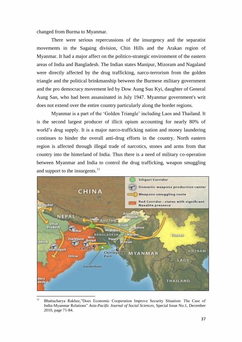
There were serious repercussions of the insurgency and the separatist
movements in the Sagaing division, Chin Hills and the Arakan region of
Myanmar. It had a major affect on the politico-strategic environment of the eastern
areas of India and Bangladesh. The Indian states Manipur, Mizoram and Nagaland
were directly affected by the drug trafficking, narco-terrorism from the golden
triangle and the political brinkmanship between the Burmese military government
and the pro democracy movement led by Dow Aung Suu Kyi, daughter of General
Aung San, who had been assassinated in July 1947. Myanmar government's writ
does not extend over the entire country particularly along the border regions.
Myanmar is a part of the ‗Golden Triangle‘ including Laos and Thailand. It
is the second largest producer of illicit opium accounting for nearly 80% of
world‘s drug supply. It is a major narco-trafficking nation and money laundering
continues to hinder the overall anti-drug efforts in the country. North eastern
region is affected through illegal trade of narcotics, stones and arms from that
country into the hinterland of India. Thus there is a need of military co-operation
between Myanmar and India to control the drug trafficking, weapon smuggling
and support to the insurgents.11
11
Bhattacharya Rakhee,‖Does Economic Cooperation Improve Security Situation: The Case of
India-Myanmar Relations‖ Asia-Pacific Journal of Social Sciences, Special Issue No.1, December
2010, page 71-84.
38
India has taken initiative to improve its economic relationship with
Myanmar by keeping possible doors open for bilateral engagement like
investment, infrastructure, trade and other co-operation. Trade with and through
Myanmar would revive India‘s north east and make both the nations prosperous.
Also, Myanmar being India‘s gateway to Association of South East Asian Nations
(ASEAN), it is the only country of this group, which has a land and maritime
boundary with India. Thus with India becoming a summit level partner of ASEAN
and a member of the East Asia Summit, improved relations with Myanmar can be
beneficial in many respects. Besides, Myanmar and India are members of other
sub regional groupings such as the Bay of Bengal Initiative for Multi - Sectoral
Technical and Economic Cooperation (BIMST-EC) and the Mekong - Ganga
Cooperation (MGC).
In 1992, following the breakup of the Soviet Union, the Indian government
launched its `Look East policy‘, which in the words of the then prime minister was
`a strategic shift in India‘s vision of the world and India‘s place in the evolving
global economy‘. Since that time, a number of initiatives have been pursued to
increase ties, largely in trade relations, between India, members of the ASEAN
and other Asian states. As India‘s gateway to East Asia, the Burmese military
regime has found itself in a key geo-strategic position, giving it a strong hand in
negotiations with India.
Though the Indo – Myanmar Friendship Road was completed in 2001,
India has not been able to exploit its potential by reaching the markets of
Southeast Asia. Indian companies have been involved in negotiations with
Myanmar in the fields of onshore and offshore explorations of oil and gas and
hydropower projects. The recent planned infrastructure development of road, rail
and waterways from Indian side are all steps in the direction of establishing
economic and business connections with Myanmar.
Kaladan Multi – Modal Transport Project –
The construction of the Kaladan multi – modal transport project
commenced in 2010 and is likely to be completed by 2015. This would facilitate
India‘s north eastern region to be linked to the Bay of Bengal through Myanmar
using the road and waterway of the Kaladan River through the Arakan state. The
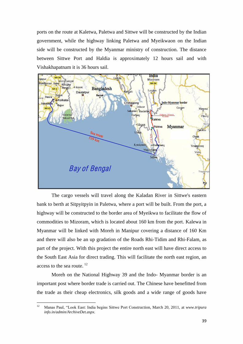
39
ports on the route at Kaletwa, Paletwa and Sittwe will be constructed by the Indian
government, while the highway linking Paletwa and Myeikwaon on the Indian
side will be constructed by the Myanmar ministry of construction. The distance
between Sittwe Port and Haldia is approximately 12 hours sail and with
Vishakhapatnam it is 36 hours sail.
The cargo vessels will travel along the Kaladan River in Sittwe's eastern
bank to berth at Sitpyitpyin in Paletwa, where a port will be built. From the port, a
highway will be constructed to the border area of Myeikwa to facilitate the flow of
commodities to Mizoram, which is located about 160 km from the port. Kalewa in
Myanmar will be linked with Moreh in Manipur covering a distance of 160 Km
and there will also be an up gradation of the Roads Rhi-Tidim and Rhi-Falam, as
part of the project. With this project the entire north east will have direct access to
the South East Asia for direct trading. This will facilitate the north east region, an
access to the sea route. 12
Moreh on the National Highway 39 and the Indo- Myanmar border is an
important post where border trade is carried out. The Chinese have benefitted from
the trade as their cheap electronics, silk goods and a wide range of goods have
12
Manas Paul, ―Look East: India begins Sittwe Port Construction, March 20, 2011, at www.tripura
info.in/admin/ArchiveDet.aspx.
40
been smuggled to the Indian market through this area. This is something which
should become a cause of worry for India.
Due to the location of the Sittwe port not very far from Kyakpiu port of
Myanmar and Chittagong port of Bangladesh it gains a serious geo - strategic
importance with India‘s presence. China is providing support to Myanmar in
developing the Kyakpiu port and constructing a road and oil-gas pipeline
connecting Kunming. China has also proposed to develop Chittagong port and
Sonadia deep sea port located seven kilometers off the Cox Bazaar. The
construction of Sittwe incidentally comes close on the heels of Myanmar‘s
elections and release of Aung Sun Swu Kyi. India, in spite of the international
pressure has remained engaged with Burmese military junta since 1993 keeping in
mind its strategic importance.
Visit of Than Shwe –
During the visit of Senior General Than Shwe to India in July 2010, the
two nations resolved to increase trade by up to $1 billion per annum. The general
expressed his satisfaction on the construction, maintenance and repair work of the
road Tamu- Kalaywa- Kalemyo connecting Moreh in Manipur to Myanmar by the
border roads organisation of India and thereafter handing over most of the
segments to the government of Myanmar.13 The Myanmar government will
commence construction and revamping of the road Rhi –Tiddim with financial
grants from India. In addition, India has also agreed to give a grant of $ 10 Million
for agricultural machinery and technical assistance to manufacture the same in
Myanmar. The Tamanthi and Shwezaye power projects on the Chindwin river
basin will be assisted by India in Myanmar. There will be a third border trading
point made functional at Avankhug- Somra (Nagaland). To patrol rivers and
deltas, India will provide fast inshore and offshore boats and interceptors. To boost
mutual legal assistance in criminal matters to combat transnational organized
crime like terrorism, drug trafficking, money laundering and smuggling of arms
and explosives, a treaty was signed. The senior general also reiterated Myanmar‘s
support for India‘s bid for permanent membership of the United Nations Security
Council (UNSC) and also India‘s candidature for a non-permanent seat in the 13
Democracy and Discontent: The 2010 Elections in Myanmar, AIIA Policy Commentary, at
www.southasiaanalysis.org/%5Cpapers40%5Cpaper3954.html
41
UNSC for the term 2011-2012. An agreement, on the strategy of increased
security cooperation and a strengthened collective effort to fight the insurgents and
combat terrorism along the border of the two countries, was also signed by the two
countries.
Insurgency and Drug Smuggling –
There is close social and cultural affinity between the tribal population on
both sides of the Indo- Myanmar border particularly in Nagaland, Manipur and
Mizoram. The area on the Myanmar side is infested with insurgent groups‘ camps
and due to logistics and hostile terrain, the Myanmar government has not been
able to exercise sovereignty and is a constraint for anti –terror operations.
For many years, India has faced an insurgency in the remote north east of
the country, with insurgent groups frequently operating from bases inside
Myanmar. Myanmar‘s military co-operation with the Indian government in
dealing with these groups has been reportedly linked with an Indian government‘s
offer to supply a variety of military hardware such as tanks, aircraft, artillery guns,
radar, small arms and advanced light helicopters. However, there are worries that
the Myanmar military may use the weapons and other military equipment, such as
helicopters, sold or donated by India for the crackdown on insurgents or against
ethnic civilians. In April 2007, it was reported that Indian and Myanmar security
forces were ―conducting joint military operations along the 1,643 kms Indo-
Myanmar border to neutralise insurgent groups.‖14 In the month of January 2010,
an agreement was also signed between India and Myanmar to conduct joint
military operations in north east and Myanmar against the Indian insurgents hiding
in the dense jungles of Myanmar. The aim was to ensure that no insurgent can
escape to the other side when facing the heat on one side. The security forces were
also to be more vigilant on the border against smuggling of drugs, arms and other
goods.15
India's concern over the transit, permanent and training camps and other
support by Myanmar on their soil to the Indian Insurgent Groups including United
Liberation Front of Assam (ULFA) has made an affect. There are rebel militias in
the Shan state and apart from that some of the insurgent groups have been active 14
www.arakanrivers.net/?page_id=147 - 45k 15
articles.timesofindia.indiatimes.com › Collections
42
against Yangon for over four decades. This was the reason why the Naga and the
Assamese groups have been finding refuge on the Myanmar side. Besides ULFA,
NSCN (Khaplang -K), PLA and ULFA from Manipur too have their camps within
Myanmar territory. Some of these camps are in the Kachin province bordering
China; the other outfits have been operating from areas bordering India. Cross
border smuggling of small arms from South East Asia and China‘s Yunnan also
exists.16
While China has long maintained a friendly relationship with Myanmar,
India appears to have changed its position on the regime over the last decade.
India‘s past calls for the release of Aung San Suu Kyi as well as for a national
political reconciliation process seem to have been replaced by a policy of
―engagement rather than sanctions as a means to exert influence over the military
administration,‖ and a new ―pragmatic stance‖ which allows it to take advantage
of new investment opportunities wherever they appear.
Even USA has now shifted its focus to Asia – Pacific where most countries
were getting concerned about the rise of China and it assertiveness. The change in
trend in Myanmar of liberalization and to have good relations with the countries of
the world will have a major impact in Asia. By taking initiatives to open talks with
the USA and other neighbouring countries it will be able to develop into an energy
and natural resources base in the sub-continent, China and the South East Asia.
United States secretary of state Hillary Clinton‘s three day visit from30
November- 02 December, the first of its kind after the 1950‘s to Myanmar has
been a welcome step as compared to imposing sanctions on the military junta
rule.17 This step is primarily to shift the focus of Myanmar from China which was
gaining an excessive grip over the country.
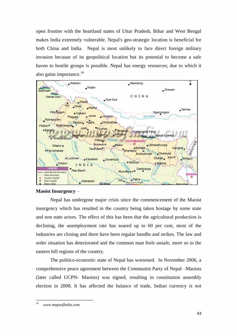
Nepal –
Nepal shares a close geographic proximity with India and China, the two
acknowledged nuclear weapons states and major powers in Asia. Nepal is closer to
Tibet and is home for 12,000 Tibetans refugees. India and Nepal had signed a
Treaty of Peace and Friendship in 1950 which guarantees the open border. Nepal‘s
16
Based on personal interviews. 17
Gautam Sen, Ethnic Tension and Political Drift in Myanmar, May 27, 2013, www.idsa.in ›
Publications › PAPERS & BRIEFS › IDSA Comment
43
open frontier with the heartland states of Uttar Pradesh, Bihar and West Bengal
makes India extremely vulnerable. Nepal's geo-strategic location is beneficial for
both China and India. Nepal is most unlikely to face direct foreign military
invasion because of its geopolitical location but its potential to become a safe
haven to hostile groups is possible. Nepal has energy resources; due to which it
also gains importance.18
Maoist Insurgency –
Nepal has undergone major crisis since the commencement of the Maoist
insurgency which has resulted in the country being taken hostage by some state
and non state actors. The effect of this has been that the agricultural production is
declining, the unemployment rate has soared up to 60 per cent, most of the
industries are closing and there have been regular bandhs and strikes. The law and
order situation has deteriorated and the common man feels unsafe, more so in the
eastern hill regions of the country.
The politico-economic state of Nepal has worsened. In November 2006, a
comprehensive peace agreement between the Communist Party of Nepal –Maoists
(later called UCPN- Maoists) was signed, resulting in constitution assembly
election in 2008. It has affected the balance of trade, Indian currency is not
18
www.mapsofIndia.com
44
available, banking and financial institutions have failed, poor supply of electricity
and supply of petroleum products is undependable. The government has not been
able to find a solution for integrating and rehabilitating the 19000 odd Maoist
insurgents. The Unified CPN- Maoists have finally joined the Government.19 The
United Nations Mission (UNMIN) ended its term in January 2011 which played an
important role in ensuring the ceasefire agreement with the Maoists and also
supported in the conduct of the elections in 2008.
China is becoming more assertive in demanding equal treatment with India
in terms of the latter‘s respective treaties with Nepal. With the Maoists now
becoming a strong political force in Nepal, and given their ideological
compulsion to be seen as drawing Nepal closer to China, coupled with their
periodic ranting calculated to inflame public opinion against India, the political
terrain has become more favourable for China.Chinese Premier had visited Nepal
on 14 January 2012 which was not made public and had announced a ―one time
special grant‖ of $20 Million as well as an assistance of 200 Million RMB ($31.75
Million) under a 750 million RMB grant spread over three years. The premier also
committed to give economic and technical support to strengthen Nepal‘s police
force. In August 2011, Baburam Bhattarai became the Prime Minister and since
then has been working towards changing the stance between India and China and
has reiterated that Nepal is not a buffer state between India and China, but is a
bridge between the two. On the economic front, India has been accounting for 44
per cent of the foreign direct investment in Nepal for the Year 2010-2011 and for
60 per cent of Nepal‘s external trade.20
Water is a sensitive issue in the relationship between India and Nepal. The
two countries have a long history of water cooperation and have signed several
water sharing treaties like Kosi (1954), Gandak (1959), and Mahakali (1997). The
Mahakali Treaty (1997), however, remains merely a document. The breach of the
Kosi embankment and the devastating floods it caused in India in 2008 has only
highlighted the importance of water in India-Nepal relations.21
19
The Tribune, Chandigarh, 06 August 2011. 20
The Tribune, Chandigarh 12 March 2012 21
Rakesh Tiwary,‖Deepening Divide over Water Share‖, Look East, Vol. 1, Issue 6, September
2010, Kolkota.
45
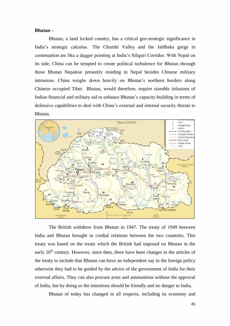
Bhutan –
Bhutan, a land locked country, has a critical geo-strategic significance in
India‘s strategic calculus. The Chumbi Valley and the Jaldhaka gorge in
continuation are like a dagger pointing at India‘s Siliguri Corridor. With Nepal on
its side, China can be tempted to create political turbulence for Bhutan through
those Bhutan Nepalese presently residing in Nepal besides Chinese military
intrusions. China weighs down heavily on Bhutan‘s northern borders along
Chinese occupied Tibet. Bhutan, would therefore, require sizeable infusions of
Indian financial and military aid to enhance Bhutan‘s capacity-building in terms of
defensive capabilities to deal with China‘s external and internal security threats to
Bhutan.
The British withdrew from Bhutan in 1947. The treaty of 1949 between
India and Bhutan brought in cordial relations between the two countries. This
treaty was based on the treaty which the British had imposed on Bhutan in the
early 20th century. However, since then, there have been changes in the articles of
the treaty to include that Bhutan can have an independent say in the foreign policy
otherwise they had to be guided by the advice of the government of India for their
external affairs. They can also procure arms and ammunition without the approval
of India, but by doing so the intentions should be friendly and no danger to India.
Bhutan of today has changed in all respects, including its economy and
46
international stature since 1949. The relationship has, thus, been one of dynamism
and change. The Chinese occupied Tibet in 1950, after which Bhutan became
suspicious of independent India's intentions. The prime minister of India
Jawaharlal Nehru stated in the parliament that any attack on Bhutan would be
considered an attack on India. Bhutan entered into the international environment
after becoming member of the Colombo Plan in 1963, which was sponsored by
India. Thereafter, it received technical assistance from other countries, became a
member of the United Nations, South Asian Association of Regional Cooperation
(SAARC) and Economic and Social Council for Asia and Pacific (ESCAP).In
1998, the transfer of power from monarchy to an elected cabinet took place. In
2008, Jigmi Y Thinley of the Druk Phuensum Tshegpa (DPT) became the first
elected Prime Minister of Bhutan.
India has been helping Bhutan in terms of completely financing the first
two five- year plans, and in many projects to include hydropower plants, cement
plants, roads, etc. The 336 MW Chukha Hydel project ensures power supply to
parts of West Bengal and Assam which has given Bhutan 40 per cent of the
external revenue. There is a free trade regime between India and Bhutan with no
customs and about 13 transit routes. Bhutan is very keen on sub-regional
cooperation through the growth quadrangle which encompasses Bangladesh,
Nepal and the north eastern parts of India. Due to the ongoing process of
normalizing relations between India and China, Bhutan has been able to
commence bilateral talks with China on the boundary issue. For India, a stable
Bhutan is very important as a buffer state.
India and Bhutan had concluded an extradition agreement in 1996. The
disturbed situation in the north east India is a serious concern with Bhutan as it
involves the presence of the Indian insurgent groups in that country. Bhutan is not
in any way assisting these insurgents, but its police forces are limited to meet such
contingencies. Due to the bilateral talks between the two countries, this issue has
been addressed and is a cause of concern.
Operation All Clear –
On 15th December 2003, Bhutanese monarch, Jigme Singye Wangchuck,
unleashed his small military machine, comprising the Royal Bhutan Army (RBA)
47
and the Royal Body Guards (RBG), to expel an excess of 3,000 heavily armed
Indian separatists belonging to three different groups, the United Liberation Front
of Assam (ULFA), National Democratic Front of Bodoland (NDFB) and the
Kamatpur Liberation Organisation (KLO). These insurgents were operating from
30 camps inside the kingdom (ULFA had 13 camps, NDFB 12 and the KLO 5).
Buddhist Bhutan had last gone to a war against any foreign force 138 years back.22
On the Indo –Bhutan border, Sashastra Seema Bal (SSB) has been
deployed as the border guarding force. An India-Bhutan group on border
management and security has been regularly meeting as part of a bilateral
mechanism. This mechanism has proved to be very useful in assessing threat
perception of the two countries from groups attempting to take advantage of this
open border and in discussing way of improving the security environment in
border areas23.
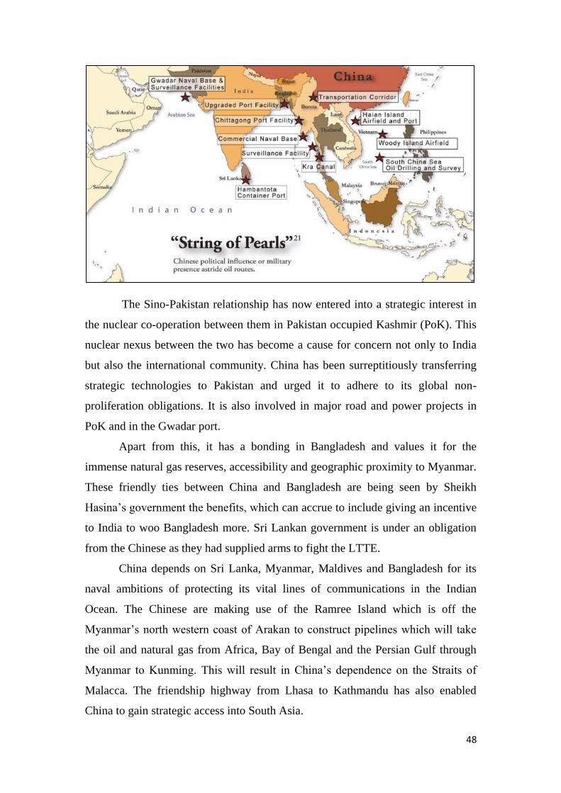
China -
The Chinese are convinced that sustained economic development has to be
accorded the highest priority. In the Chinese concept of the comprehensive
national power, both soft and hard powers are equally relevant. To enhance its
global power, it requires strategic space, enlarged area of influence and to ensure
this, it has formulated an Asia policy which involves making inroads into south
and south East Asia.
China, with its increased political, economic and military weight, is
stepping up its presence in countries around India. The core of China‘s policy is to
enhance its economic interests by keeping a peaceful and stable environment
particularly along its strategic periphery. The so called `String of Pearls‘ strategy,
with commercial goals in view in the short term and military goals in the long
term, includes construction of new port facilities in select countries. To promote
these objectives China is bound to ante its engagement with these countries,
especially with its increasing material means at its disposal, posing further
challenges to India‘s interests in its neighbourhood.
22
Wasbir Hussain, ―Insurgency in India‘s North East Cross-border Links and Strategic Alliances‖,
Strategic Analysis, Vol. 33, No 6, November 2009. 23
Ministry of Home Affairs, Annual Report - 2011-12.
48
The Sino-Pakistan relationship has now entered into a strategic interest in
the nuclear co-operation between them in Pakistan occupied Kashmir (PoK). This
nuclear nexus between the two has become a cause for concern not only to India
but also the international community. China has been surreptitiously transferring
strategic technologies to Pakistan and urged it to adhere to its global non-
proliferation obligations. It is also involved in major road and power projects in
PoK and in the Gwadar port.
Apart from this, it has a bonding in Bangladesh and values it for the
immense natural gas reserves, accessibility and geographic proximity to Myanmar.
These friendly ties between China and Bangladesh are being seen by Sheikh
Hasina‘s government the benefits, which can accrue to include giving an incentive
to India to woo Bangladesh more. Sri Lankan government is under an obligation
from the Chinese as they had supplied arms to fight the LTTE.
China depends on Sri Lanka, Myanmar, Maldives and Bangladesh for its
naval ambitions of protecting its vital lines of communications in the Indian
Ocean. The Chinese are making use of the Ramree Island which is off the
Myanmar‘s north western coast of Arakan to construct pipelines which will take
the oil and natural gas from Africa, Bay of Bengal and the Persian Gulf through
Myanmar to Kunming. This will result in China‘s dependence on the Straits of
Malacca. The friendship highway from Lhasa to Kathmandu has also enabled
China to gain strategic access into South Asia.
49
Sino - Indian Border Dispute –
The Sino - Indian border dispute is distant from any settlement. There is no
commonly delineated Line of Actual Control (LAC) between the two countries.
There have been differences in the perception of the LAC which have resulted in
untoward situations. These could have been avoided if there were common
perceptions. China has been making claims over Arunachal Pradesh, which has
forced India to improve its infrastructure and raising of additional two infantry
divisions in the north eastern region. The Siliguri corridor gains importance due to
the Chinese plan of a trade route from the Kolkata port through the corridor,
Chumbi valley and on to Yardong in Tibet. The Chinese had occupied Tibet in
1950.There is an indirect recognition of Tibet being part of China by India and
Sikkim as part of India by China. Agreement to open trade route through Nathula
has the above effect/meaning. The situation of the Siliguri corridor has further
been extended into Nepal and connected all along India‘s eastern coast up to
Andhra Pradesh by the dangerous Red Corridor.
China and India have now widened their scope of their engagement to
include climate change, energy security, food security and restructuring
institutions of global governance. However, contradictions on issues of high
politics, especially regarding China‘s sub-Himalayan strategic involvement,
remain unaltered, enabling analysts to effortlessly paint an adversarial image.
India‘s security interests are in its periphery, while China is linked to its threat
perceptions over Tibet and its overland strategic infrastructure (road and rail links,
port development) part of a policy of periphery consolidation and to secure and
exploit potential geo-economic opportunities in the long-term as Beijing seeks to
develop southern and western China.
Due to India‘s own vulnerable status in the global nuclear system, it had
become difficult for it to critique China‘s proliferation record. In the coming years
the fundamental dichotomy of Sino-Indian relations, discord at the regional level
and collaboration at the global level is unlikely to disappear. China has been
reframing its terms of relationship with the west.Similarly, India too has
persevered to reshape its own equation with the major powers .There is a need for
India to revise its own posture: from a grieving to a confident aspiring regional
50
power. The strategic community has a growing myth that China is on the cusp of
acquiring a permanent presence in the Indian Ocean region, whereas the reality is
that China is constrained in East Asia, surrounded by the most formidable naval
armada. China‘s eastern seaboard is regularly patrolled by the American
submarines and aircraft carriers in close proximity to making the notion of China
as an Indian Ocean power a distant aspiration. Therefore, China remains
essentially a continental power.
Support to the Insurgency in the North east –
The Indian Government has confirmed that China was meddling in the
affairs of the restive North eastern states. There were strong inputs that suggested
that some rebel leaders of these states had visited China several times to seek its
help in procuring arms. The Chinese have been supporting the Indian insurgent
groups which involved the insurgents visiting China and in turn being supplied
with machine guns and AK-47 rifles. The revelation of this came about when a
Chinese firm encashed a crossed cheque of half a million dollars for purchasing
arms for NSCN (IM). Minister of State for Home Mullapally Ramachandran, in a
written response to a question in Rajya Sabha on 09 March 2011, said that there
have been inputs suggesting the visit of some of leaders of insurgent groups in the
north eastern region to China with the objective of establishing a rapport with
Chinese authorities to facilitate procurement of arms and ammunition from arms
agents in that country. Acquisition of arms by the insurgents groups is facilitated
by easy availability of weapons in Sino- Myanmar borders towns like Tenchong,
Ruili and Yingjiang in Yunnan Province. This serious issue has also been voiced
by the Government of India with the Governments of Myanmar and Bangladesh.24
There were reports that a Chinese woman spy Wang Qing had visited
Nagaland in January 2011, which happened to be her second visit after August
2010. There were conflicting reports of the police and the Kolkota based national
daily about her visit to the NSCN (IM) headquarters at Hebron near Dimapur and
also being briefed there. However, she was deported by the Government of India
after her arrest and in all probability it was primarily that the centre didn‘t want to
make an issue of it, for the sake of friendly relations with China and the ongoing
24
The Tribune, Chandigarh, 10 March 2011.
51
talks with the Naga Leaders.25
The Himalayas are called the ―water tower‖ of South Asia. Most of the
water in India‘s northern rivers originates in Tibet. China annexed Tibet in 1950
and thereby gained control over the Himalayan glaciers of the region from which
some of the world‘s largest rivers originate and flow to South Asia and South East
Asia. China has strengthened its political and economic control on Tibet. India and
China have a complex, unresolved boundary dispute in Tibet. Thus, water has
assumed higher priority in Sino-Indian relations in the recent years. There are
widespread fears in India that China is planning to divert the waters of the
Brahmaputra River to meet the demand in the arid north. The Chinese anti-
draught project envisages the diversion of the Brahmaputra to the arid Xinjiang
and adjoining region where close to ten million people face water shortage. They
are planning to construct a dam on the Yarlung Tsangpo River, high up in the
Tibetan plateau. Any blocking of the river either by way of building any kind of
dams or by simply diverting it will have irreparable and devastating impact on the
ecosystems and the peoples way of life in Tibet, Arunachal Pradesh, Assam and
also in the lower reaches of Bangladesh.26
India’s Look East Policy -
India‘s Look East policy was developed and enacted during the
government of Prime Minister P.V. Narasimha Rao in 1992 and rigorously
pursued by the successive governments of Atal Bihari Vajpayee and Manmohan
Singh. It marked a strategic shift in India‘s perspective of the world. It is
imperative that from the Look East policy objective, India should integrate itself
with the South and South East Asian countries and the rest of the world to further
its future strategic and economic interests. There are ample common factors to
include racial, cultural and linguistic between north east India and South East
Asia. The policy will result in the economic development of the backward north
eastern region of India taking advantage of huge market of Association of South
East Asian Nations (ASEAN) as well as of the energy resources available in some
of the member countries of ASEAN like Myanmar. Phase one of the policy was
25
The Statesman, Kolkota , 6 February 2011. 26
Binoda Kumar Mishra, ―China Eyes on Brahmaputra Waters‖, Look East, Vol. 1, Issue 6
September 2010, Kolkota.
52
aimed on trade and investment linkages, while phase two is focused on security
cooperation, construction of transport corridors and erecting pillars of linkages and
connectivity.
In 1997, a sub-regional grouping, called BIST-EC, comprising Bangladesh,
India, Sri Lanka and Thailand was established. In 2004, with the addition of
Myanmar, Bhutan and Nepal it became BIMSTEC. Mekong Ganga Cooperation
(MCG) project was launched on November 10, 2000, at Vientiane, capital of Laos
and was known as the Vientiane Declaration. The signatories to the treaty were
India and five other South East Asian Nations i.e Myanmar, Thailand, Laos,
Cambodia and Vietnam. The primary thrust of the project is aimed at the
development in three main areas of tourism and culture, infrastructure and
Information Technology.27
The Look East policy envisages the north east region not as the periphery
of India, but as the centre of a thriving and integrated economic space linking two
dynamic regions with a network of highways, railways, pipelines, transmission
lines crisscrossing the region. With this as the objective and to enhance the
connectivity between the north east and Southeast Asia, India has concluded a
number of bilateral and multilateral projects. India has also constructed the 165
km long Indo-Myanmar friendship road connecting Tamu and Kalaymyo-Kalewa.
Some of the other projects which are underway and have been planned are India-
Myanmar-Thailand Trilateral Highway, Trans Asian Highway, India-Myanmar
rail linkages, Kaladan Multimodal project, the Stilwell road, Myanmar-India-
Bangladesh gas and oil pipeline, Tamanthi Hydroelectricity project and optical
fiber network between North east India and Southeast Asia.28
The Kaladan multi-modal transit transport facility will provide an alternate
route for transport of goods to north east India. The second India-Myanmar border
trade point at Rhi - Zowkhathar in Mizoram to be made functional by upgradation
of the Rhi - Tidim and Rhi - Falam road segments in Myanmar. There are plans
for a rail link from Jiribam in Assam to Hanoi in Vietnam passing through
27
Sayantani Sen Mazumdar ―Mekong- Ganga Cooperation- A Brief Overview‖, Global India
Foundation- MSS Mazumdar –at www.globalindiafoundation.org. 28
Julien Lévesque, ―Northeast in India‘s Look East Policy‖, Institute of Peace and Conflict Studies,
Article No. 2558, 6 May 2008, New Delhi.
53
Myanmar. However, to achieve the above there are geographical, technical,
political and security challenges that limit the process of infrastructure
development.
India has signed a ‗Long Term Cooperative Partnership for Peace and
Prosperity‘ with ASEAN and is using the comprehensive economic cooperation
agreement as a template for Free Trade Agreements (FTAs). The end result of this
has been that India is negotiating bilateral FTAs with East Asian economic powers
to include Thailand and Singapore and free-trade area with Brunei, Indonesia and
Malaysia.29 India‘s trade with countries bordering the north east has seen the most
dramatic expansion, with the share going up more than five times since 1992-93.
However, this trade expansion with India‘s eastern neighbors has had little or no
impact on the north east as most of it has taken place through the seaports. It
would not be incorrect to argue that the north east has once again been
marginalized. India is looking east, but not through its contagious north eastern
borders. There is a need that the north eastern region should develop industrially.
The `North East Industrial Policy 2007‘ has practically made the whole region a
special economic zone. The states of north east India in the Look East Policy
except as a site for events such as the ASEAN-India car rally in 2004 and 2012
have played no major role. The Chinese have on the other hand pursued a closer
relationship with its neighbours in the South and South East Asia through its
province of Yunnan. India has been concentrating on the insurgency problem in
the north east, thus the Look East Policy concessions and aid has been primarily to
seek the support of the neighbouring countries to expel the insurgent groups
seeking shelter in their countries and to dismantle their camps. Some of the
countries have cooperated and flushed out insurgent groups from their areas.
The Indian Government is possibly hesitant to showcase its Look East
policy through the north eastern region due to the following;
(a) The insurgency and ethnic conflicts though under control, but have a
cascading effect in the states which have a border with the neighbouring
countries.
(b) The geo-strategic and the security concerns have been given more
29
Manipur Online, December 25, 2010. at manipuronline.com › Look-East Policy
54
consideration.
(c) The Chinese have made inroads into the markets of the region selling cheap
stuff.
(d) The Government is looking for passage through Bangladesh and Myanmar
to the sea ports and not at the various highways which have been planned
as per the Look East policy to connect the South East Asian countries. The
sea routes are cheaper than the land routes.
![Community Based Adaptation in Action BIOENERGY · COMMUNITY BASED ADAPTATION IN ACTION] [ABSTRACT Bangladesh, due to its geo-physical position and socio-economic context, is highly](https://img.pdfslide.us/doc/110x75/5e50188a9bd7862ab42d8dfd/community-based-adaptation-in-action-community-based-adaptation-in-action-abstract.jpg)