Embed Size (px)
Citation preview
1
Introduction and Geographical Setting
Chapter 1
2
INTRODUCTION
There are many organisms on this planet. In them, human is the most powerful
animal on the basis of his brain. Thereare has three basic needs of man 1.Food 2.Cloth
3.Shelter. In the primitive stage, he used tree branches, caves or rock-cut for shelter.
After that, there was a change in man’s work with respect to space and time and that
influenced his settlement. That is why his shelter was converted into Hamlet, Village, Town
and finally into city and this hierarchy was mostly influenced by physical, social, economical
and cultural factors. These factors also influenced the distribution, spacing and morphology
of settlement.
The term settlement refers to man made habitats on the earth surface. In other words,
settlement is organized colony of human beings consisting of buildings in which they live or
work or store various things and street on which their movements take place.
The study of settlement has been one of the most significant themes of human
geography. The term “settlement geography” is derived from the German” siedlunge
geographic” (R. L. Singh 1978) which involves the study of visual imprints made by man
upon cultural landscape in the process of occupation. In the beginning various settlement
features bore simpler forms and relationship with the environment, with the growth of
civilization and technical knowledge, the degree of variability in their size, form and
complexity of their relationship became overwhelming greater. This needs for the perfection
of any study and for the understanding of the concerned surrounding environment as a
whole.
Rural settlement as a pioneer habitat of human being is a living functional space.
Rural settlement means a rural space occupied by rural community with their economic,
social and cultural environment. This environment influences the entire rural way of life and
their dynamic structure. Geographers look at the rural settlements as agglomeration of man-
made habitat on the earth which is dependent mostly on primary occupation.
3
PREVIOUS WORK DONE
Settlement geography is concerned with the spatial and temporal variations in the
processes of settling and their manifestations on the earth’s surface. Abundant literature of
settlement geography is available, particularly on the towns of the developed countries.
However, our knowledge of current process, growth, configuration, problems and
implication of development of rural settlement in developing country like India is still
limited (south India).
Review of the relevant literature is divided into two parts i.e. Indian works and
Foreign works.
INDIAN WORKS
Subrahmanyam (1938) has worked on house types in relations to physiography and
building materials.
Deshpande (1942) has analyzed types of settlement in Bombay – Karnataka in
relation to graphical factors and his study revealed that the site of rural settlement in drier
was mainly determined by fresh water supply and that although relief and transport system
influenced the pattern of settlement, nature of agricultural operations also had the decided
influence especially there, where the field and crop therein needed frequent attention as in
Kokan.
Ali (1992) has discussed rural type, pattern, location, sitting and types of rural
dwellings in Ghargha Plain in relation to the distribution of population
B. Mukharjee (1947) has made valuable contribution in her Doctoral thesis on the
changing settlement in the Hooghly region of the lower Ganga plain.
E Ahmad (1948) has given details about study of settlement of both rural and urban
in the long settled fertile state of Uttar Pradesh. He also described the Indian village pattern
based largely on the study of One-inch topographical maps.
He also described various physical and cultural factors which are responsible for
various types and patterns of rural settlements in the study area.
4
Singh (1950) has made the analysis of the landscape of a tribal village named –
Bharabharis, in the Chotanagpur plateau, with habitations on plants and fields at lower levels
and has established the role of environment on the mode of life of all the communities living
in the village.
Lahiri (1950) has done the study of four typical settlements of Ajoy Barakar basin
and has stressed the physical growth of settlement through successive stages of young
maturity and old.
A. B. Mukerjee (1953) studied Jat settlements and habitations and made valuable
contribution in this field. He has also worked on Moradabad and Bijnor districts. He has
described growth and distribution of rural settlement and explained the various types and
patterns and gave suggestions for the development of rural landscape of region.
R. L. Singh (1961) studied “Evolution of settlement in the middle Ganga Valley”
and provided guidelines to investigators in this field. He has explained the meaning,
objectives and scope of rural settlement geography. He also described origin, growth
distribution and morphology of rural settlement as well as rural house types in the study
regions.
Viswanath (1956) has studied the settlement pattern of the deltaic district of
Thanagavur in Tamil Nadu. Linear settlements predominate in the alluvial tract along the
sandy coast, whereas the nucleated settlements are mainly found in the black soil region and
scattered settlements predominate in less fertile soil region
Bhattacharya (1956) has studied the settlement pattern in the upper Ganga plain of
U. P. He has mainly concentrated on the study of settlements of Jat, Rajput and Ahirs and
has found that they preferred to live close together in large agglomerated habitation and not
necessarily close to the farm.
Bhattacheraya and Varma (1957) have studied types of rural settlement in upper
Son valley. Their study revealed that culture provided with security has helped the growth of
hamlets near marshes and fields, whereas the dissected relief and dense forests have caused
dissemination and isolated farmsteads in the midst of forest clearings and cultivable patches.
5
L. R. Singh (1965) has studied rural settlement in the Tarai region of U.P. He has
given detailed analysis of the evolution, growth and distribution of rural settlement. He
further discussed the socio economic condition of villagers, population composition, spacing
of rural settlement and physical- cultural elements which are dominating factors for the
development of rural settlement.
R. C. Sharma (1972) he has studied in detail about settlement of the Indian desert.
He has deduced that general distributional pattern of rural settlement is clearly the effect of
physical relief, rain fall distribution extent of cultivated area, means of irrigation and impact
of the network of transport lines. He has found that the settlement types and house types in
the area are the result of adaptation of local physical conditions.
A. Prasad. (1969) has studied “rural settlements of Chotanagpur” and has explained
their evolution, types and spatial distribution. He also co-related physical landscape with
various aspects of settlements.
J. P. Sharma (1975) has done the study of rural dwellings and house types in the
Himalayan Ravi – Chenave in interfluves. He also proved that the physico–economic and
socio- cultural conditions in the region have determined the site, plain, shape, size building
material, roof type and style of construction of rural houses to the great extent.
V. N. P. Sinha (1976) has studied “Chotanagpur plateau: a study in settlement
geography”,which analyses and interprets the growth, pattern, types of rural settlement. A
special emphasis has been laid on the geographical conditions that determine evolution,
distribution, morphology and functional character of the rural settlement. He also analyzed
economic and social conditions, which have influenced typology of rural settlement and
rural dwellings.
R. B. Mandal (1979) has studied the form of settlements which are determined by
social requirements and the physical environment. The origin of settlements took place near
cross roads, houses of land lords and hermits .He also told the types of rural settlements in
India, selected area of Jammu and Kashmir and desert areas of Rajasthan and also told where
settlements sitting is selective either on slope or on oasis pattern of rural settlements which
determine the shape, size and structure of rural settlements. They correlate the rainfall,
6
income with housing and conditions in terms of materials and studied the rural service
centers. He has made a modest attempt to highlight the problems of rural settlements and the
need for their planning in North Bihar in 1981.
Anjana P Desai (1985) has illustrated spatial aspects of settlement patterns with case
study of Mahesana district of North Gujarat.
Neelam Grover (1985) he has studied the rural settlements: A cultural-
Geographical Analysis “A case study of Northern Haryana”, historically an ancient culture
comprise six different cultural groups dominantly, they are Rajput, Gujar, Jat and Kanet each
practicing their own genera device.
Haushila Prasad (1986) has studied physical environment and settlements in
Missouri region. He has used co-relation technique to show that how settlements are
distributed in the association of altitudinal zones, relative relief, dissection index, slope and
drainage density of the region.
S. C. Singh and S.B. Singh (1988) have studied settlements distribution and their
co-relation with morph metric attributes in Simla hills. Their study reveals that there are
some stretches which are not suitable for the growth of settlements, which correspond with
the areas of steep slopes and high relief. In his study it was found that physical environment
and their influence on the distribution of settlements is more than other factors. By such
studies one should take into account that altitude plays an important role for the growth and
development of the rural settlements in the mountainous and hilly regions.
A.P. Kumbhar (1996) has studied rural habitat as regional study of rural settlements
in Nira valley. In this research monograph an attempt has been made to study the rural
settlements in various perspectives. He analyzed distribution of rural settlements, spacing,
centrality and functional gap. He also described in detail various factors which have
influenced on distribution, types, pattern, site and spacing of rural settlements in the study
region. He has also explained morphogenesis as well as nucleation and dispersion of rural
settlements.
7
FOREIGN WORKS
Vidal de la Blache (1926) was a French settlement geographer who studied human
geography in detail.
Demangeon (1920) emphasized the study of field ownership, cultivation, building
material, house types and the distribution of towns, rural settlements and human habitations.
Aurosseau (1920) an Australian Geographer used the term arrangement for the
grouping of dwellings in their typical form and found close relationship with physical factors
like soil, topography, climate, and water in a region. Their external forms reflect
architectural styles of the time, culture and reason from which they spring. Their
distributional pattern is distinguishable in their landscape when once created they outline
both the function for which originally designed and the architectural style of their time and
thus they reflect changes in human occupancies of an area often being the only relict
expressions of the past cultural landscape.
Miss Lefevre (1921 & 1964) Belgium Geographer has made some major
contribution. Her study concentrates on rural settlement patterns and density. She has also
suggested that rural habitat be reserved for the residence of persons who worked on the soil.
This idea of Lefevre was seconded by Demangeon in 1931.
Matui (1932) was Japani geographer who analysed rural settlements geography
quantitatively.
Bruhnes (1953) in his study he explained that houses and highways are the two
fundamental facilities and settlements are topographic expressions of their groupings or
arrangements.
Isaiaz Bowan (1931) has drawn attention mainly to the rural aspects. He has studied
the pioneer fringe of settlement.
Losh (1954) has shown the deviation of the market areas of the central places for
different sizes of regions and he gave mathematical solutions through equations.
E. Socfield (1938) and Trewartha (1946) are of the view that the compact rural
villages in the U.S.A. reflect colonization by homogeneous ethnic or religious groups.
8
Kollmorgen and Jenks (1951) have found a line pattern of rural settlement
developing in an area originally laid out on a rectangular pattern in the wheat lands of
western Kansas.
Barnes (1936) examined the relative merits of the rectangular and linear patterns of
rural settlements. He found that the standard rectangular pattern characteristic of large parts
of the U.S.A. was actually very costly in terms of public services.
Hudson (1969) has emphasized the location of rural settlements through
colonization, spread and competition of people and he concludes that these processes are
cyclic in nature.
Bylund (1960) has presented his ideas of settlement diffusion in space through
deterministic models.
Morril (1963) and Haggerstand have developed probabilistic models of settlement
diffusion through stochastic processes and random number.
Grosaman (1971) has emphasized the theory of location of rural settlements with the
process of the migration of people from one settlement to the other.
Mills (1972) has classified the villages as closed and open villages on the basis of
single ownership and multiple ownerships respectively.
Michael Chisholm (1973) studied rural settlement and land use. Distance is the
central theme of this book, an attempt to provide a systematic account of certain features of
rural settlement and land use.
F.S. Hudson (1977) in his book “Geography of settlements” the major part of the
subject is concerned with urban geography, towns and cities are the most striking man-made
features on the earth’s surface. He described and tried to interpret the site and situation,
building material, form and functions of small settlements and the pattern they make on the
map as well as the characteristics of urban settlements.
Hugh D. Clout (1977) has presented in his book “Rural geography, an introductory
survey”. The first of them involves out-migration from the countryside, leading to
9
depopulation which has affected many parts of the developed world during and after their
periods of industrialization.
The second theme involves the recent repopulation of some rural areas in the post-
war age of increased personal mobility as car-owning urbanities that choose to move in to
the countryside for residence on a permanent or a part time basis and for recreation.
The third group of chapter discusses selected systematic aspects of planned and
unplanned change in the countryside.
Paul J. Cloke (1983) has studied the changes in rural settlements in England and
Wales. He explained the constant dynamism taking place in the countryside and the resultant
fluctuations both in the nature of settlements and communities in their demands as well as
requirements.
OBJECTIVES:-
1. To analyze place names.
2. To understand the impact of physical determinants like Relief, Slope,
Rainfall, Soil, Drainage on the distribution of settlement.
3. To understand the impact of human determinants like road and railway on the
distribution of settlement.
4. To study the types and patterns of settlements
5. To explain size and spacing of settlements.
6. To understand the hierarchy of rural service centre.
7. To analyze the demographic characteristics of settlements.
HYPOTHESIS:-
There is an impact of physical and human factors on the development of rural
settlements.
10
SOURCE OF DATA
This study has emphasized mainly spatial analysis of settlements. For this purpose,
data obtained from the primary and secondary sources supplemented in making general
observations. Most of the secondary data obtained from district census hand book, socio-
economics review and statistical abstracts, Gazetteers of Ahmadnagar District and other
government and private institutes. Primary data collected at the village level with the help of
questionnaires, interviews of farmers and residences of villagers.
METHODOLOGY
Recent years have seen a marked increase in the application of models and many
different descriptive and inferential statistical techniques to the geographical problems.
To examine the influence of some selected physical and cultural variables on the
distribution of settlement co-relation technique is used. For the indices of agglomeration and
dispersion of settlements developed by Bernard, Demongeon, Deboureive and Houston are
computed to explain the various types of settlements in the study area, Nearest Neighbour
Analysis, Spacing method, use of one-dimensional diagrams, use of choroplath techniques
etc. are used. To understand the pattern of settlement researcher used Google earth image.
Centrality index is computed to determine the centrality score values, which are
worked out by taking into account various functions performed and services. Five decades
census data is used for this proposed research work.
Karl Pearson’s Method of co-relation: -
Σ (x - ̄ x) (y -̄ y) σ x = √Σ (x - ̄ x) / n
r = ---------------------
σ x * σ y σ y = √Σ (y -̄ y) / n
11
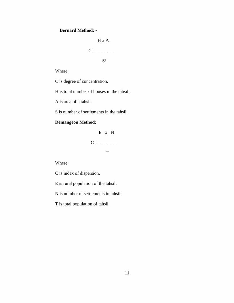
Bernard Method: -
H x A
C= ------------
S²
Where,
C is degree of concentration.
H is total number of houses in the tahsil.
A is area of a tahsil.
S is number of settlements in the tahsil.
Demangeon Method:
E x N
C= -------------
T
Where,
C is index of dispersion.
E is rural population of the tahsil.
N is number of settlements in tahsil.
T is total population of tahsil.
12
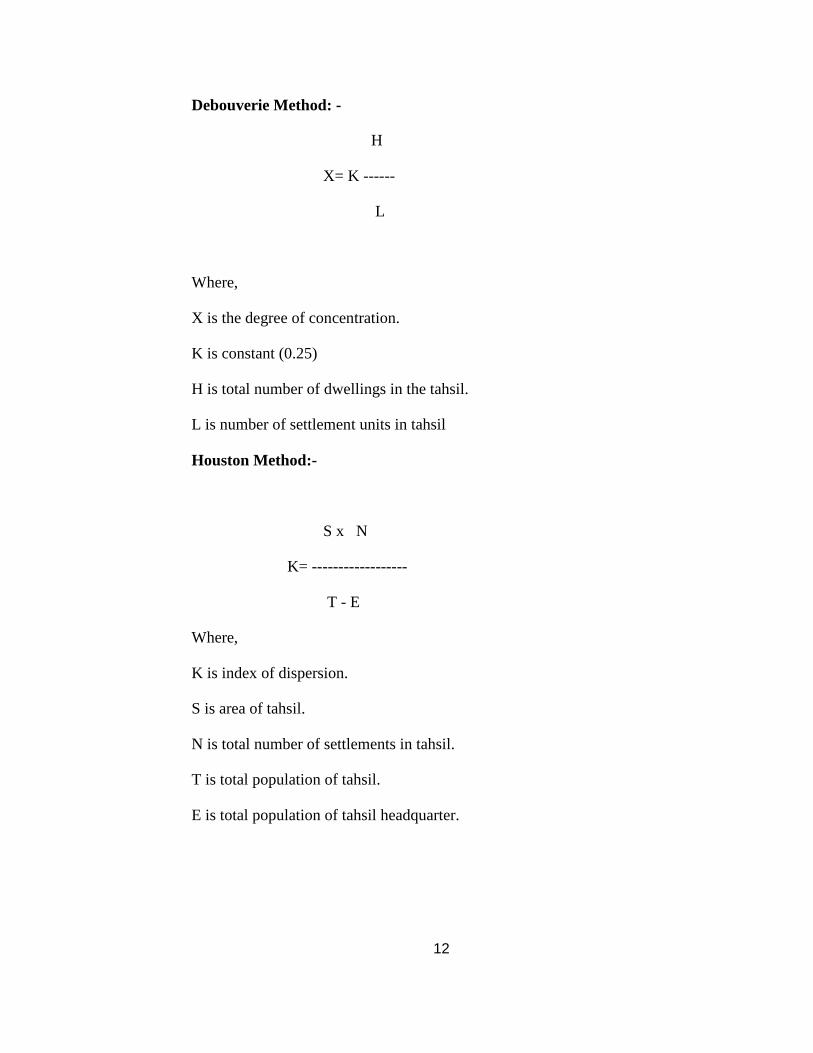
Debouverie Method: -
H
X= K ------
L
Where,
X is the degree of concentration.
K is constant (0.25)
H is total number of dwellings in the tahsil.
L is number of settlement units in tahsil
Houston Method:-
S x N
K= ------------------
T - E
Where,
K is index of dispersion.
S is area of tahsil.
N is total number of settlements in tahsil.
T is total population of tahsil.
E is total population of tahsil headquarter.
13
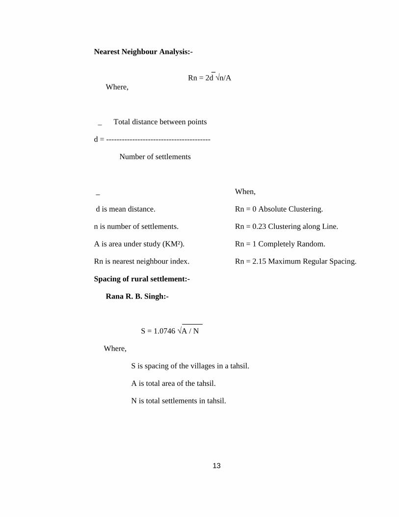
Nearest Neighbour Analysis:-
_ Rn = 2d √n/A Where,
_ Total distance between points
d = ----------------------------------------
Number of settlements
_ When,
d is mean distance. Rn = 0 Absolute Clustering.
n is number of settlements. Rn = 0.23 Clustering along Line.
A is area under study (KM²). Rn = 1 Completely Random.
Rn is nearest neighbour index. Rn = 2.15 Maximum Regular Spacing.
Spacing of rural settlement:-
Rana R. B. Singh:-
S = 1.0746 √A / N
Where,
S is spacing of the villages in a tahsil.
A is total area of the tahsil.
N is total settlements in tahsil.
14
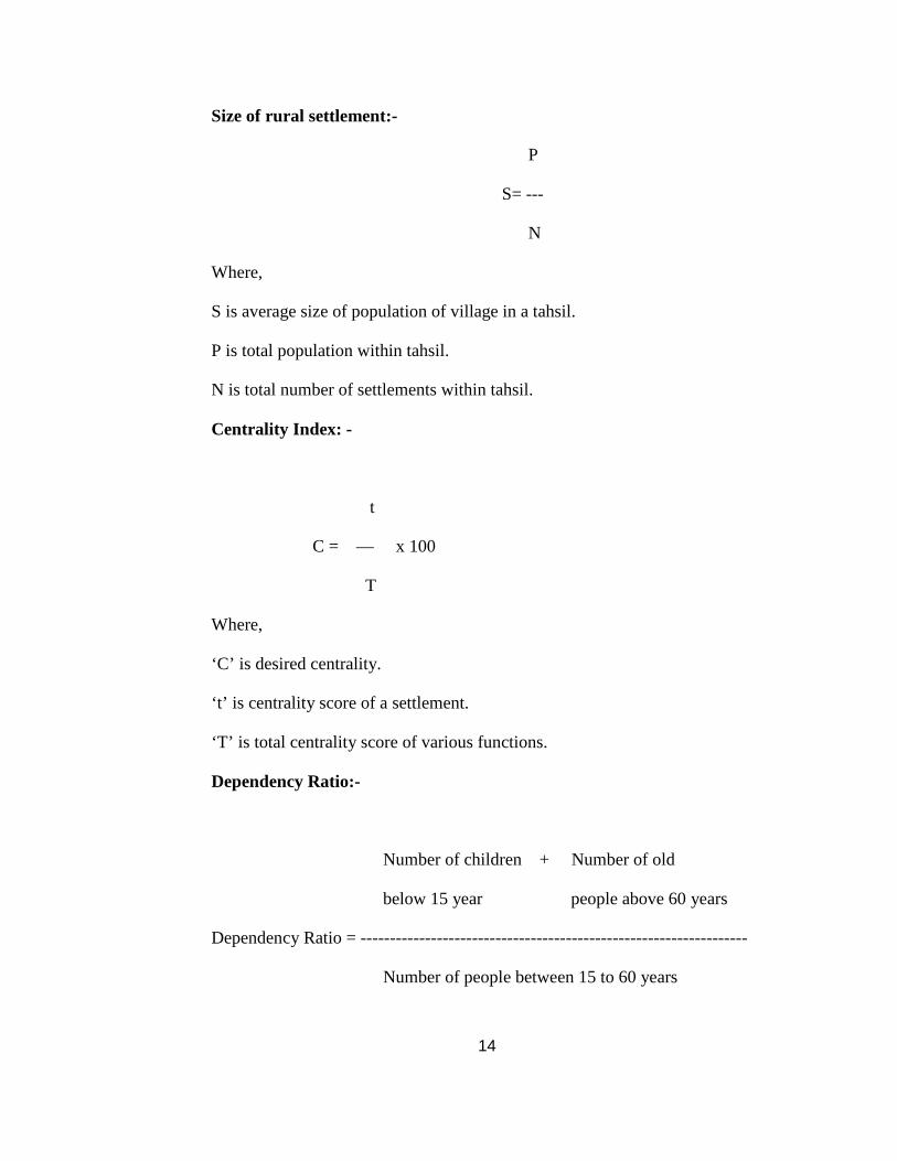
Size of rural settlement:-
P
S= ---
N
Where,
S is average size of population of village in a tahsil.
P is total population within tahsil.
N is total number of settlements within tahsil.
Centrality Index: -
t
C = — x 100
T
Where,
‘C’ is desired centrality.
‘t’ is centrality score of a settlement.
‘T’ is total centrality score of various functions.
Dependency Ratio:-
Number of children + Number of old
below 15 year people above 60 years
Dependency Ratio = ------------------------------------------------------------------
Number of people between 15 to 60 years
15
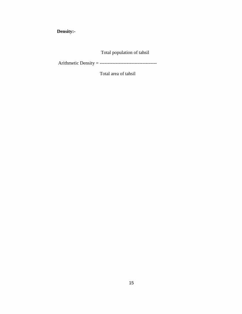
Density:-
Total population of tahsil
Arithmetic Density = ------------------------------------
Total area of tahsil
16
DESIGN OF THE PROPOSED RESEARCH WORK
1. The first chapter introduces physical setting of the region (location, geology,
relief, drainage, climate, soil.), socio-economic background of study area.
(Population growth, population density, cast-wise population, literacy, land
use pattern and cropping pattern.) This chapter also throws light on social
amenities in study area. (Education, medical facilities, drinking water, post
and telegraph, transportation)
2. The second chapter covers the place names which are grouped according to
their relation to various natural and cultural features.
3. Third chapter studies the distributional factors of settlement in study region.
Factors such as Relief, Slope, Drainage, Rainfall, Soil Type, Roadway,
Railways.
4. The forth chapter deals with Type, Pattern, Size and Spacing of rural
settlement.
5. In fifth chapter an attempt has made to identify rural service centers in study
region and hierarchy of rural service centers also considered in this chapter.
6. The sixth chapter gives comparison of demographic characteristics of
settlements in last five decade. It includes population growth rate, population
density, sex ratio, population of scheduled castes and scheduled tribes and
literacy.
7. Seventh chapter deals with case studies of few selected villages. In this
chapter an attempt has been made to highlight the various characteristics of
rural settlements in the study area.
8. The last chapter deals with observations and conclusions based on the study.
Finally the references, bibliography, articles and reports are listed.
17
LOCATION OF STUDY REGION:-
Ahmadnagar district is situated partly in the upper Godavari basin and partly in the
Bhima basin occupying somewhat central position in Maharashtra state. Its extent is 18° 2’
to 19° 9’ north latitudes and 73° 9’ to 75° 5’ east longitudes. The district is irregular in shape
and resembles a slanting cross with a length of 200 Kms. and a breadth of 210 Kms. It is
surrounded by Nasik district to north, Aurangabad district to the north-east, Beed district to
the east, Osmanabad and Solapur district to the south, Pune district to the west and Thane
district to the north-west. Ahmadnagar district lies in Nashik administrative division of
Maharashtra. (Figure No. 1.1)
18
Figure No. 1.1 Location of Ahmadnagar District
19
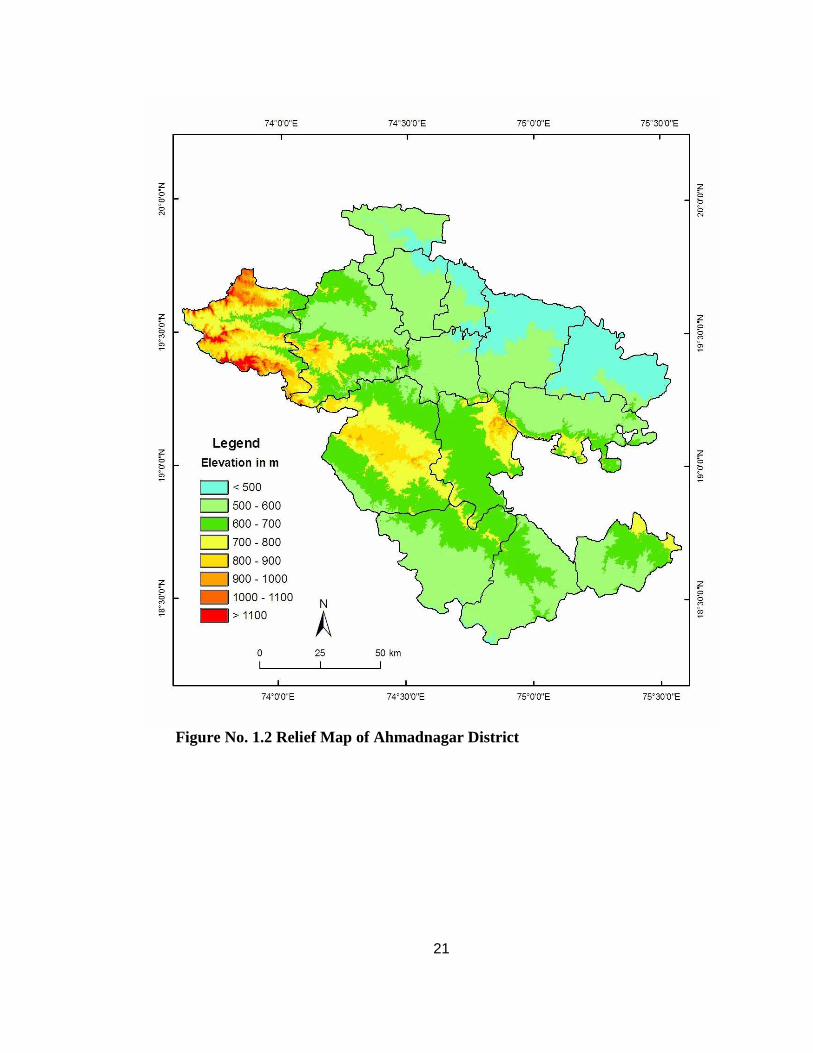
RELIEF OF STUDY REGION:-
The whole district lies on the elevated tableland of the Deccan which has a general
slope from west to east. The western subdivision of Akola, which abouts on the Sahyadris is
the highest part of the district and indeed of the Deccan, averaging 762 metres above sea
level. The plain of the Shevgaon which lies to the extreme east of the district is not more
than 457 metres above the sea. The district can be divided into three parts. (Figure No. 1.2)
1. The plains or Basins :-
In the north, central and east are the fertile alluvial plains of Kopargaon, Shrirampur,
Rahta, Rahuri, Nevasa and Shevgaon lying in the valley of the Godavari. In the extreme
south there are the alluvial but less fertile plains of Shrigonda and Karjat lying in the valley
of Bhima.
2. The Plateaux:-
Plateau merges into the other often through sharp-crested ridges. These are mainly in
the Sangamner, Parner, Nagar and Jamkhed.
3. The Sahyadri Hill Range:-
The Sahyadri Mountains spread upto 40 Kms. Distance. It is a continuous natural
boundary between the Ahmadnagar and Thana districts. The west view of it is the wall of
rock about 610 to 915 metres high, having isolated peaks and rocky bluffs rising in many
places to a further hight of 305 to 460 metres.
In the Ahmadnagar district, the Sahyadri is divided into three great spurs, i.e.
Kalsubai, Baleshvar and Harishchandragad.
i. Kalsubai Range:-
In the northernmost side of the three spurs, for about 40 Kms. forms the boundary
between the Ahmednagar and Nasik district. Its view from the Nasik side presents the
appearance of a continuous and in many places having a precipitous wall of rock. It holds
series of rockey and very steep peaks averaging about 1524 metres height followed by
Kalsubai (1647 metres) which is the highest point in the Mahrashtra state. In the East side of
the Kalsubai is a natural depression in the range over which winds the Bari pass road leading
20
from the Rajor hills to the plain of the Darna River in Nasik district. The next noteworthy
peaks are Palan, Bitangad and Mahakali. There are two smaller spurs which run in a south-
easterly direction, enclosing the valley of the Adula river, branch off near Bitangad and
Patta. The two flat topped hills of Tava 1075 Metres and Raula which lie a few kilometres
north of the town of Akola are conspicuous objects from all parts of the Pravara valley.
Another striking hill is Manbhav 918 metres which lie east of Tava on the boundary between
Akola and Sangamner.
ii. Baleshvar Range:-
The Baleshwar range is the second great spur of the Sahyadris, which branches off at
Ratangad 11 Kms. south-east of Kulang, completely traverses the Akola and Sangamner
sub-divisions forming in the north the valley of Pravara and in the south the valley of Mula.
To the East side of Ratangad there is a series of lofty mountains.
iii. Harishchandragad Range:-
The third range which leaves the Sahyadris at Harishchandragad is the longest in the
district and forms the water shed between the Godavari and the Bhima rivers. It’s direction
for the first 24 kms. is easterly shutting in the valley of the Mula river which flows between
it and the Baleshvar range and forming the boundary line between the Ahmadnagar and Puna
district. Near Brahmanvada the range, gradually decreasing in height, takes a turn to south-
east crosses the corner of the Junner sub-division of Puna and enters Parner which it
completely traverses. The summits of the hills here widen into the plateau of Kanhur.
21
Figure No. 1.2 Relief Map of Ahmadnagar District
22
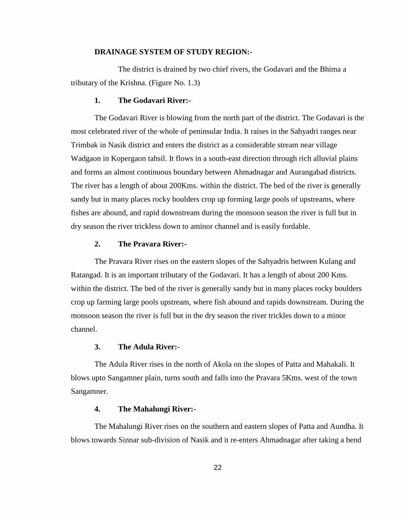
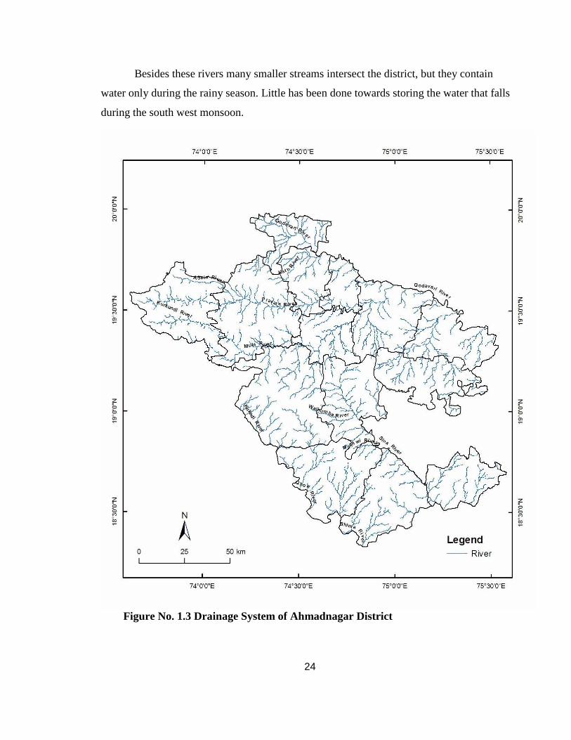
DRAINAGE SYSTEM OF STUDY REGION:-
The district is drained by two chief rivers, the Godavari and the Bhima a
tributary of the Krishna. (Figure No. 1.3)
1. The Godavari River:-
The Godavari River is blowing from the north part of the district. The Godavari is the
most celebrated river of the whole of peninsular India. It raises in the Sahyadri ranges near
Trimbak in Nasik district and enters the district as a considerable stream near village
Wadgaon in Kopergaon tahsil. It flows in a south-east direction through rich alluvial plains
and forms an almost continuous boundary between Ahmadnagar and Aurangabad districts.
The river has a length of about 200Kms. within the district. The bed of the river is generally
sandy but in many places rocky boulders crop up forming large pools of upstreams, where
fishes are abound, and rapid downstream during the monsoon season the river is full but in
dry season the river trickless down to aminor channel and is easily fordable.
2. The Pravara River:-
The Pravara River rises on the eastern slopes of the Sahyadris between Kulang and
Ratangad. It is an important tributary of the Godavari. It has a length of about 200 Kms.
within the district. The bed of the river is generally sandy but in many places rocky boulders
crop up farming large pools upstream, where fish abound and rapids downstream. During the
monsoon season the river is full but in the dry season the river trickles down to a minor
channel.
3. The Adula River:-
The Adula River rises in the north of Akola on the slopes of Patta and Mahakali. It
blows upto Sangamner plain, turns south and falls into the Pravara 5Kms. west of the town
Sangamner.
4. The Mahalungi River:-
The Mahalungi River rises on the southern and eastern slopes of Patta and Aundha. It
blows towards Sinnar sub-division of Nasik and it re-enters Ahmadnagar after taking a bend
23
to the south and still preserving a course parallel to that of Adula, it joints the Pravara at the
town of Sangamne. Its flow is seasonal.
5. The Mula River:-
The Mula River rises on the eastern slopes of the Sahyadris between Ratangad and
Harishchandragad. The total distance from its source to its meeting with Pravara at the
Sangam is about 145 Kms. except in the lower part of its course, on account of the great
depth of its bed, the water of the Mula is little used for irrigation.
6. The Dhora River:-
The Dhora River rises on the slopes of the hills east of the town of the Ahmadnagar.
It flows north-easterly, draining the Shevgaon and part of the Nevasa sub-division and falls
into the Godavari at Paithan. Its total length is 56 Kms.
7. The Bhima River:-
The whole of the southern portion of the district lies in the Bhima basin. The Bhima
however, passes only on the boundary between Ahmadnagar and Pune districts for a distance
about 60 Kms. The Bhima rises close to Bhimashankar in Pune district and enters in
Ahmadnagar district near village Sangavi Dumale in Shrigonda tahsil and flows in a south
east direction. The bank of the river is generally low and the bed is generally sandy crossed
at a few places by rocky barriers. The chief tributaries of the Bhima are the Ghod and the
Sina. Bhima River is having the length within Ahmadnagar district is 56 Kms. The course of
the Bhima is continuously to the south east.
8. The Ghod River:-
The Ghod River rises on the slopes of the Sahyadris in the Junnar sub-division of
Pune. It flows in a south easterly direction for about 80 Kms. within the district.
9. The Sina River:-
The Sina river has two chief sources one near Jamgaon 23 Kms. west of the town of
Ahmadnagar and the other near Jeur 16 Kms. to the north-east. After flowing through the
city forms a part of the boundary between Ahmadnagar and Bid district. It joins the Bhima
River in Solapur district a few miles south of Solapur city.
24
Besides these rivers many smaller streams intersect the district, but they contain
water only during the rainy season. Little has been done towards storing the water that falls
during the south west monsoon.
Figure No. 1.3 Drainage System of Ahmadnagar District
25
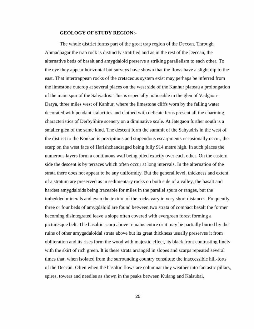
GEOLOGY OF STUDY REGION:-
The whole district forms part of the great trap region of the Deccan. Through
Ahmadnagar the trap rock is distinctly stratified and as in the rest of the Deccan, the
alternative beds of basalt and amygdaloid preserve a striking parallelism to each other. To
the eye they appear horizontal but surveys have shown that the flows have a slight dip to the
east. That intertrappean rocks of the cretaceous system exist may perhaps be inferred from
the limestone outcrop at several places on the west side of the Kanhur plateau a prolongation
of the main spur of the Sahyadris. This is especially noticeable in the glen of Vadgaon-
Darya, three miles west of Kanhur, where the limestone cliffs worn by the falling water
decorated with pendant stalactites and clothed with delicate ferns present all the charming
characteristics of DerbyShire scenery on a diminative scale. At Jategaon further south is a
smaller glen of the same kind. The descent form the summit of the Sahyadris in the west of
the district to the Konkan is precipitous and stupendous escarpments occasionally occur, the
scarp on the west face of Harishchandragad being fully 914 metre high. In such places the
numerous layers form a continuous wall being piled exactly over each other. On the eastern
side the descent is by terraces which often occur at long intervals. In the alternation of the
strata there does not appear to be any uniformity. But the general level, thickness and extent
of a stratum are preserved as in sedimentary rocks on both side of a valley, the basalt and
hardest amygdaloids being traceable for miles in the parallel spurs or ranges, but the
imbedded minerals and even the texture of the rocks vary in very short distances. Frequently
three or four beds of amygdaloid are found between two strata of compact basalt the former
becoming disintegrated leave a slope often covered with evergreen forest forming a
picturesque belt. The basaltic scarp above remains entire or it may be partially buried by the
ruins of other amygadaloidal strata above but its great thickness usually preserves it from
obliteration and its rises form the wood with majestic effect, its black front contrasting finely
with the skirt of rich green. It is these strata arranged in slopes and scarps repeated several
times that, when isolated from the surrounding country constitute the inaccessible hill-forts
of the Deccan. Often when the basaltic flows are columnar they weather into fantastic pillars,
spires, towers and needles as shown in the peaks between Kulang and Kalsubai.
26
In the face of the hill at Kothul, a small village in Shrigonda 39 Kms. south of
Ahmadnagar there is a thick stratum of close grained gray homogeneous basalt. In the water
courses near Kadus in Parner are columns of basalt of a bluish gray colour, compact texture,
vitreous hue, and sharp fracture. Columns also occur abundantly in the slop of the hills on
either side of a very narrow valley running westward from the village of Akolner in the
Nagar tahsil.
Sheet of rock of considerable superficial extent and totally destitute of soil occur in
all parts of the district but especially in the hilly tracts. They are intersected by fissures lined
internally on both sides with layers of chalcedony, cachalong, hornstone and semiopal the
innermost layer being frequently composed of crystals of quartz generally colourless and
sometimes, through rarely, associated with Calcspar. These veins together with the nodules
of the amygdaloids, supply the majority of the siliceous minerals so abundantly strewn over
district.
CLIMATE OF STUDY REGION:-
The climate of the district is characterized by a hot summer and general dryness
except during the south west monsoon season. The year can be divided into four seasons.
The cold season from December to February is followed by the hot season from March to
the first week of June till the end of September there is rainy season while October and
November constitute the post monsoon or retreating monsoon season.
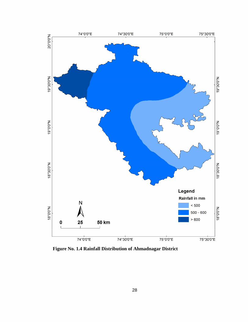
The average annual rainfall in the district is 578.8 mm. The distribution of rainfall is
very uneven. (Figure No. 1.4) The western part of Akola tahsil gets good rainfall and the
rainfall decreases as one proceeds towards east. The district mostly lies in the rain shadow to
the east of the Sahyadries, September is the rainiest month. About 77 % of the annual
rainfall is received during the south-west monsoon season. The variation in rainfall from
year to year is large.
Seasonal variation in temperature is quite large from March onwards is a period of
continuous increase in day temperatures the nights remaining comparatively cool. May is the
hottest month of the year with the mean daily maximum temperature at 38.9 ° C. On
individual days temperatures occasionally rise to 43° C to 44° C. With the onset of the south
27
west monsoon there is an appreciable drop in temperatures and the water becomes pleasant.
With the withdrawal of the monsoon day temperatures increase but night temperatures
progressively decrease from about the middle of November both day and night temperatures
decrease rapidly. December is the coldest month of the year with the mean daily minimum
temperature at 11.7° C. In association with the passage of western disturbances across north
India during winter season, the minimum temperature in the district sometimes drops to 2° C
or 3° C.
Except during the south-west monsoon season, the air generally dry particularly so in
the afternoons. Skies are generally clear or lightly clouded during most of the year. During
the south-west monsoon season, the skies are heavily clouded to overcast. Winds are
generally light to moderate in force with some strengthening during the monsoon season.
Thunder storms occur during the months of March to June and the September and
October. In association with the monsoon depression that form in the Bay of Bengal and
move across the central parts of the country, the district experiences cloudy to overcast skies
and wide spread heavy rain.
28
Figure No. 1.4 Rainfall Distribution of Ahmadnagar District
29
SOILS OF STUDY REGION:-
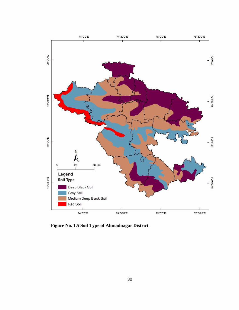
The soils of the district can broadly be classified into three groups viz black or Kali,
Rad Laterite and the Gray of inferior quality locally known as barad. The plains in
Kopargaon and Shrirampur tahsil have comparatively a good depth of soil. Near the Pravara
and Godavari rivers wide tracts of deep rich lands are found. The soils in the Mula valley on
the other hand are comparatively lighter. In the Adula valley, there is a good deal of fertile
land bordering the river banks. Further up in the hilly areas to the west of Akola, red soil
derived by residual weathering of the Basalts in a tropical humid climate depper on the
slopes than on the levels is found. Near the range of hills that run south-east down the centre
of Shrigonda and Karjat tahsil the land is very poor with occasional patches of good light
soil near Karjat and other places. (Figure No. 1.5)
Soils on the plateau vary considerably depending upon the terrain and slop
conditions. Over the plateau in many parts of Parner tahsil, the soils though not very deep
have a good admixture of lime. However, on the terraces, the soils are too inferior and the
hill slopes are stony. Fairly productive black soils are seen only in low grounds. In the
western parts of Sangamner tahsil the soils are fertile along the banks of the Pravara and
Mula that develop only in narrow strips. On the hills in the plateau, the soils are friable and
mixed with gravel.
The chief soils of the entire Godavari basin are kali or black with a variety of
gradations depending upon the local terrain conditions and slopes. The soils, by and large
derived from weathering of basalts under tropical semi-arid climatic conditions are regurs
(black cotton soil). The plains of Sangamner tahsil on either side of the Pravara and Mula,
occur rich munjal soil, a raddish sandy loom and chopan soil which are admirably suited for
garden cropping.
30
Figure No. 1.5 Soil Type of Ahmadnagar District
31
DEMOGRAPHIC STATUS OF STUDY REGION:-
Table No. 1.1 Demographic Status of Study Region
Tahsil Total Population Male Population (%)
Female Population (%)
Akola 266638 50.65 49.35 Sangamner 441439 51.41 48.59 Kopargaon 277170 51.83 48.17
Rahta 288279 51.61 48.39 Shrirampur 256458 51.32 48.68
Nevasa 326698 51.62 48.38 Shevgaon 203676 51.21 48.79 Pathardi 214872 51.25 48.75
Nagar 606690 52.60 47.40 Rahuri 294924 51.70 48.30 Parner 246552 50.31 49.69
Shrigonda 277356 51.58 48.42 Karjat 205674 51.74 48.26
Jamkhed 134216 51.30 48.70 District 4040642 51.55 48.45
Source: 2001 census of Ahmadnagar District
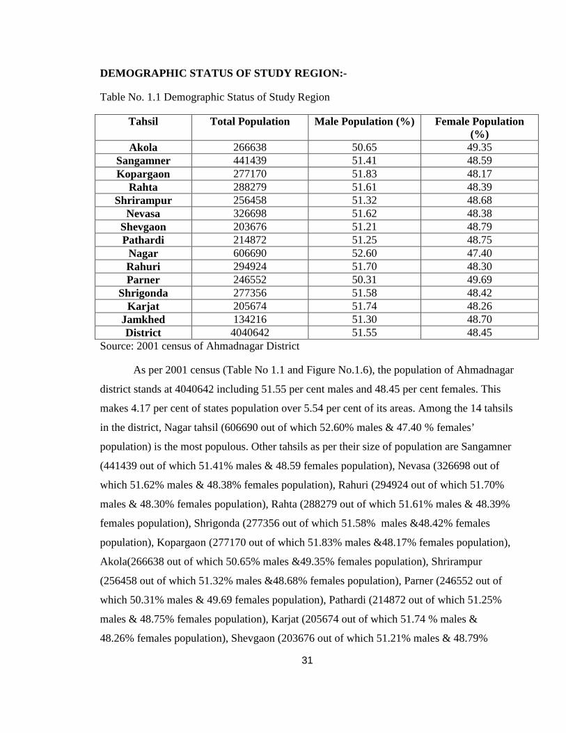
As per 2001 census (Table No 1.1 and Figure No.1.6), the population of Ahmadnagar
district stands at 4040642 including 51.55 per cent males and 48.45 per cent females. This
makes 4.17 per cent of states population over 5.54 per cent of its areas. Among the 14 tahsils
in the district, Nagar tahsil (606690 out of which 52.60% males & 47.40 % females’
population) is the most populous. Other tahsils as per their size of population are Sangamner
(441439 out of which 51.41% males & 48.59 females population), Nevasa (326698 out of
which 51.62% males & 48.38% females population), Rahuri (294924 out of which 51.70%
males & 48.30% females population), Rahta (288279 out of which 51.61% males & 48.39%
females population), Shrigonda (277356 out of which 51.58% males &48.42% females
population), Kopargaon (277170 out of which 51.83% males &48.17% females population),
Akola(266638 out of which 50.65% males &49.35% females population), Shrirampur
(256458 out of which 51.32% males &48.68% females population), Parner (246552 out of
which 50.31% males & 49.69 females population), Pathardi (214872 out of which 51.25%
males & 48.75% females population), Karjat (205674 out of which 51.74 % males &
48.26% females population), Shevgaon (203676 out of which 51.21% males & 48.79%
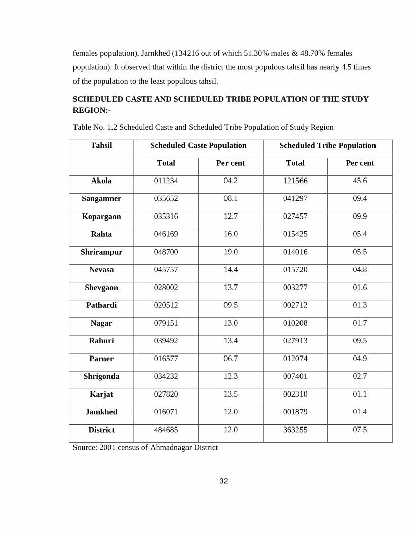
32
females population), Jamkhed (134216 out of which 51.30% males & 48.70% females
population). It observed that within the district the most populous tahsil has nearly 4.5 times
of the population to the least populous tahsil.
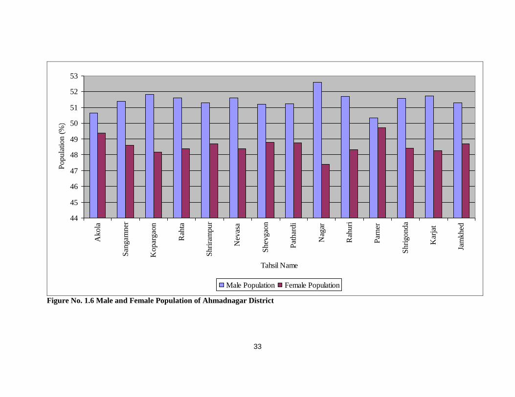
SCHEDULED CASTE AND SCHEDULED TRIBE POPULATION OF T HE STUDY REGION:-
Table No. 1.2 Scheduled Caste and Scheduled Tribe Population of Study Region
Scheduled Caste Population Scheduled Tribe Population Tahsil
Total Per cent Total Per cent
Akola 011234 04.2 121566 45.6
Sangamner 035652 08.1 041297 09.4
Kopargaon 035316 12.7 027457 09.9
Rahta 046169 16.0 015425 05.4
Shrirampur 048700 19.0 014016 05.5
Nevasa 045757 14.4 015720 04.8
Shevgaon 028002 13.7 003277 01.6
Pathardi 020512 09.5 002712 01.3
Nagar 079151 13.0 010208 01.7
Rahuri 039492 13.4 027913 09.5
Parner 016577 06.7 012074 04.9
Shrigonda 034232 12.3 007401 02.7
Karjat 027820 13.5 002310 01.1
Jamkhed 016071 12.0 001879 01.4
District 484685 12.0 363255 07.5
Source: 2001 census of Ahmadnagar District
33
44
45
46
47
48
49
50
51
52
53
Ako
la
San
gam
ner
Kop
arga
on
Rah
ta
Shr
iram
pur
Nev
asa
She
vgao
n
Pat
hard
i
Nag
ar
Rah
uri
Par
ner
Shr
igon
da
Kar
jat
Jam
khed
Tahsil Name
Pop
ulat
ion
(%)
Male Population Female Population
Figure No. 1.6 Male and Female Population of Ahmadnagar District
34
0
5
10
15
20
25
30
35
40
45
50
Ako
la
San
gam
ner
Kop
arga
on
Rah
ta
Shr
iram
pur
Nev
asa
She
vgao
n
Pat
hard
i
Nag
ar
Rah
uri
Par
ner
Shr
igon
da
Kar
jat
Jam
khed
Tahsil Name
Popu
latio
n (%
)
S.C. Population S.T. Population
Figure No. 1.7 S.C and S.T. Population of Ahmadnagar District
35
At the time of 2001 census (Table No 1.2 and Figure No.1.7), scheduled caste and
scheduled tribe population in Ahmadnagar district was 484685 and 303255 including
247545 & 153590 males and 237140 & 149665 females respectively. They constitute 12 per
cent and 7.5 per cent of total population of the district.
According to tahsil wise scheduled caste and scheduled tribe population against the
total population of the tahsil was Akola (4.2% &45.6%), Sangamner (8.1% & 9.4%),
Kopargaon (12.7% & 9.9%), Rahta (16% & 5.4%), Shrirampur (19% & 5.5%), Nevasa
(14.4% & 4.8%), Shevgaon (13.7% & 1.6%), Pathardi (9.5% & 1.3%), Nagar (13% &
1.7%), Rahuri (13.4% & 9.5%), Parner(6.7% & 4.9%), Shrigonda (12.3% & 2.7%), Karjat
(13.5% & 7.1%), Jamkhed (12% & 1.4%). Among these Shrirampur stand first and Akola
stand last for the scheduled caste population. In scheduled tribe population Akola stands first
and Karjat is last in rank.
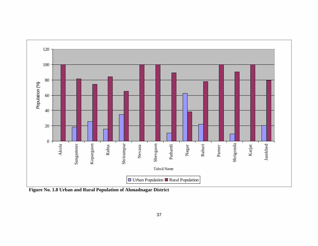
DISTRIBUTION OF POPULATION IN RURAL AND URBAN AREAS OF
THE STUDY REGION:-
As per the 2001 census (Table No.1.3 and Figure No.1.8) of Ahmadnagar district out
of 4040642 persons, 3236945 (80.11%) live in the countryside and the remaining 803697
(19.89%) in the urban area. The tahsil wise rural urban status compared with its own
population (tahsil) of Ahmadnagar district was as follows Akola (100%), Sangamner
(81.58% & 18.42%) Kopargaon (74.45% & 25.55%), Rahta (84.32% & 15.68%),
Shrirampur (65.39% & 34.61%), Nevasa (100%), Shevgaon (100%), Pathardi (89.38% &
10.62%), Nagar (38.03% & 61.97%), Rahuri (78.02% & 21.98%), Parner (100%), Shrigonda
(90.51% & 9.49%), Karjat (100%), Jamkhed (79.40% & 20.60%). In the Ahmadnagar
district topmost urbanized tahsils are namely Nagar, Shrirampur, Kopargaon, Rahuri, and
Jamkhed. Without urbanization tahsils are Akola, Nevasa, Shevgaon, Parner and Karjat.
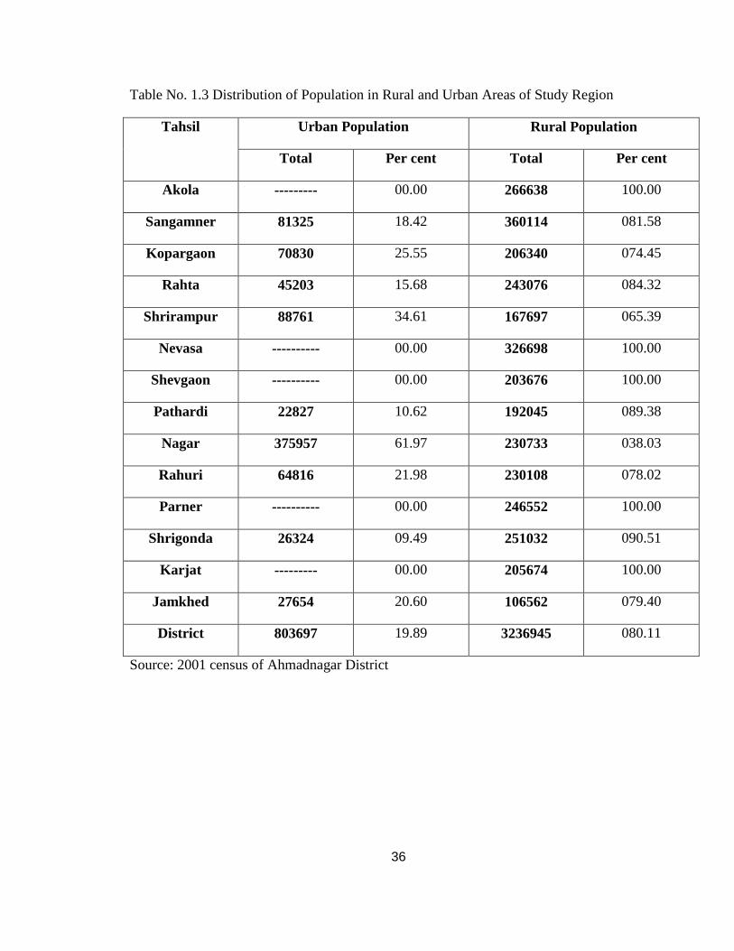
36
Table No. 1.3 Distribution of Population in Rural and Urban Areas of Study Region
Urban Population Rural Population Tahsil
Total Per cent Total Per cent
Akola --------- 00.00 266638 100.00
Sangamner 81325 18.42 360114 081.58
Kopargaon 70830 25.55 206340 074.45
Rahta 45203 15.68 243076 084.32
Shrirampur 88761 34.61 167697 065.39
Nevasa ---------- 00.00 326698 100.00
Shevgaon ---------- 00.00 203676 100.00
Pathardi 22827 10.62 192045 089.38
Nagar 375957 61.97 230733 038.03
Rahuri 64816 21.98 230108 078.02
Parner ---------- 00.00 246552 100.00
Shrigonda 26324 09.49 251032 090.51
Karjat --------- 00.00 205674 100.00
Jamkhed 27654 20.60 106562 079.40
District 803697 19.89 3236945 080.11
Source: 2001 census of Ahmadnagar District
37
0
20
40
60
80
100
120
Ako
la
Sa
ng
am
ne
r
Ko
pa
rga
on
Ra
hta
Sh
rira
mp
ur
Ne
vasa
Sh
evg
ao
n
Pa
tha
rdi
Na
ga
r
Ra
hu
ri
Pa
rne
r
Sh
rigo
nd
a
Ka
rjat
Jam
khe
d
Tahsil Name
Popu
latio
n (%
)
Urban Population Rural Population
Figure No. 1.8 Urban and Rural Population of Ahmadnagar District
38
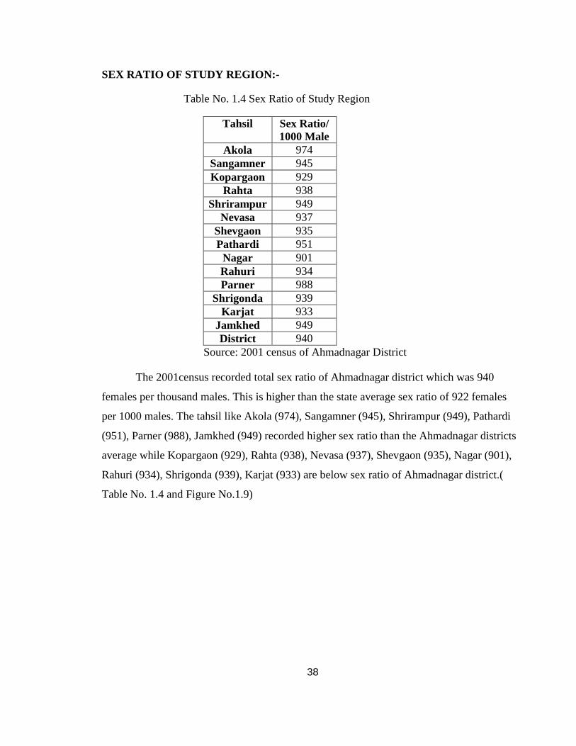
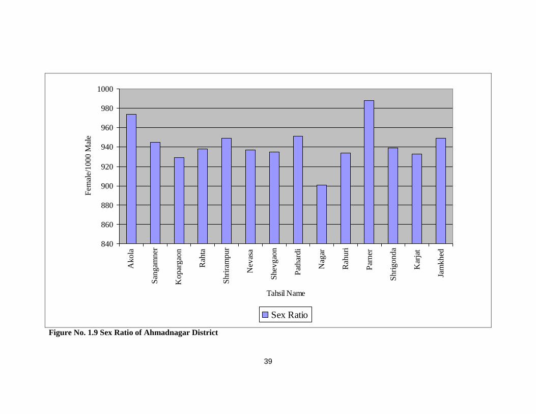
SEX RATIO OF STUDY REGION:-
Table No. 1.4 Sex Ratio of Study Region
Tahsil Sex Ratio/ 1000 Male
Akola 974 Sangamner 945 Kopargaon 929
Rahta 938 Shrirampur 949
Nevasa 937 Shevgaon 935 Pathardi 951 Nagar 901 Rahuri 934 Parner 988
Shrigonda 939 Karjat 933
Jamkhed 949 District 940
Source: 2001 census of Ahmadnagar District
The 2001census recorded total sex ratio of Ahmadnagar district which was 940
females per thousand males. This is higher than the state average sex ratio of 922 females
per 1000 males. The tahsil like Akola (974), Sangamner (945), Shrirampur (949), Pathardi
(951), Parner (988), Jamkhed (949) recorded higher sex ratio than the Ahmadnagar districts
average while Kopargaon (929), Rahta (938), Nevasa (937), Shevgaon (935), Nagar (901),
Rahuri (934), Shrigonda (939), Karjat (933) are below sex ratio of Ahmadnagar district.(
Table No. 1.4 and Figure No.1.9)
39
840
860
880
900
920
940
960
980
1000
Ako
la
San
gam
ner
Kop
arga
on
Rah
ta
Shr
iram
pur
Nev
asa
She
vgao
n
Pat
hard
i
Nag
ar
Rah
uri
Par
ner
Shr
igon
da
Kar
jat
Jam
khed
Tahsil Name
Fem
ale/
1000
Mal
e
Sex Ratio
Figure No. 1.9 Sex Ratio of Ahmadnagar District
40
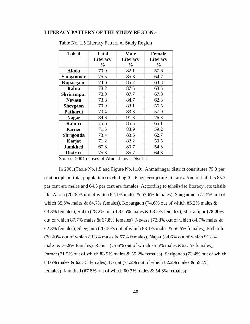
LITERACY PATTERN OF THE STUDY REGION:-
Table No. 1.5 Literacy Pattern of Study Region
Tahsil Total Literacy
%
Male Literacy
%
Female Literacy
% Akola 70.0 82.1 57.6
Sangamner 75.5 85.8 64.7 Kopargaon 74.6 85.2 63.3
Rahta 78.2 87.5 68.5 Shrirampur 78.0 87.7 67.8
Nevasa 73.8 84.7 62.3 Shevgaon 70.0 83.1 56.5 Pathardi 70.4 83.3 57.0 Nagar 84.6 91.8 76.8 Rahuri 75.6 85.5 65.1 Parner 71.5 83.9 59.2
Shrigonda 73.4 83.6 62.7 Karjat 71.2 82.2 59.5
Jamkhed 67.8 80.7 54.3 District 75.3 85.7 64.3
Source: 2001 census of Ahmadnagar District
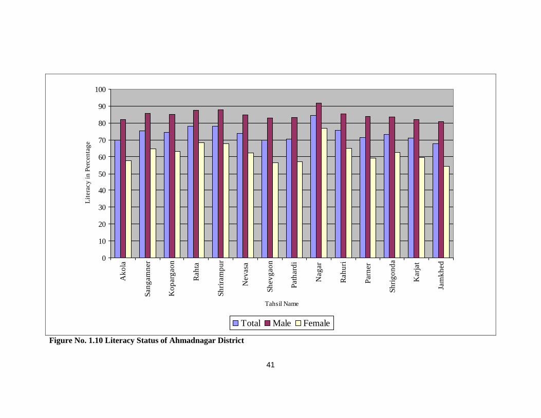
In 2001(Table No.1.5 and Figure No.1.10), Ahmadnagar district constitutes 75.3 per
cent people of total population (excluding 0 – 6 age group) are literates. And out of this 85.7
per cent are males and 64.3 per cent are females. According to tahsilwise literacy rate tahsils
like Akola (70.00% out of which 82.1% males & 57.6% females), Sangamner (75.5% out of
which 85.8% males & 64.7% females), Kopargaon (74.6% out of which 85.2% males &
63.3% females), Rahta (78.2% out of 87.5% males & 68.5% females), Shrirampur (78.00%
out of which 87.7% males & 67.8% females), Nevasa (73.8% out of which 84.7% males &
62.3% females), Shevgaon (70.00% out of which 83.1% males & 56.5% females), Pathardi
(70.40% out of which 83.3% males & 57% females), Nagar (84.6% out of which 91.8%
males & 76.8% females), Rahuri (75.6% out of which 85.5% males &65.1% females),
Parner (71.5% out of which 83.9% males & 59.2% females), Shrigonda (73.4% out of which
83.6% males & 62.7% females), Karjat (71.2% out of which 82.2% males & 59.5%
females), Jamkhed (67.8% out of which 80.7% males & 54.3% females).
41
0
10
20
30
40
50
60
70
80
90
100
Ako
la
Sa
ng
am
ne
r
Ko
pa
rga
on
Ra
hta
Sh
rira
mp
ur
Ne
vasa
Sh
evg
ao
n
Pa
tha
rdi
Na
ga
r
Ra
hu
ri
Pa
rne
r
Sh
rigo
nd
a
Ka
rjat
Jam
khe
d
Tahsil Name
Lit
era
cy in
Pe
rce
nta
ge
Total Male Female
Figure No. 1.10 Literacy Status of Ahmadnagar District
42
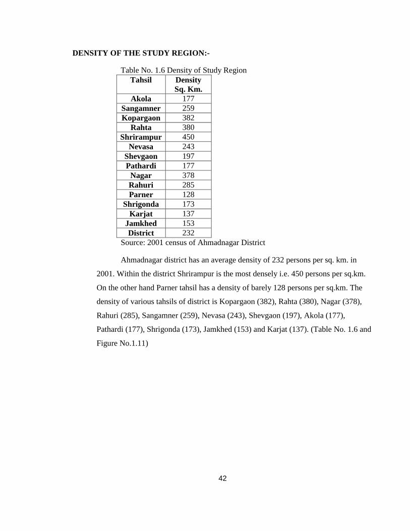
DENSITY OF THE STUDY REGION:-
Table No. 1.6 Density of Study Region Tahsil Density
Sq. Km. Akola 177
Sangamner 259 Kopargaon 382
Rahta 380 Shrirampur 450
Nevasa 243 Shevgaon 197 Pathardi 177 Nagar 378 Rahuri 285 Parner 128
Shrigonda 173 Karjat 137
Jamkhed 153 District 232
Source: 2001 census of Ahmadnagar District
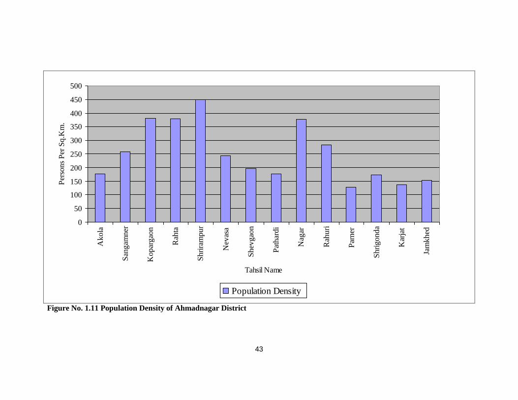
Ahmadnagar district has an average density of 232 persons per sq. km. in
2001. Within the district Shrirampur is the most densely i.e. 450 persons per sq.km.
On the other hand Parner tahsil has a density of barely 128 persons per sq.km. The
density of various tahsils of district is Kopargaon (382), Rahta (380), Nagar (378),
Rahuri (285), Sangamner (259), Nevasa (243), Shevgaon (197), Akola (177),
Pathardi (177), Shrigonda (173), Jamkhed (153) and Karjat (137). (Table No. 1.6 and
Figure No.1.11)
43
0
50
100
150
200
250
300
350
400
450
500
Ako
la
San
gam
ner
Kop
arga
on
Rah
ta
Shr
iram
pur
Nev
asa
She
vgao
n
Pat
hard
i
Nag
ar
Rah
uri
Par
ner
Shr
igon
da
Kar
jat
Jam
khed
Tahsil Name
Per
sons
Per
Sq.
Km
.
Population Density
Figure No. 1.11 Population Density of Ahmadnagar District
44
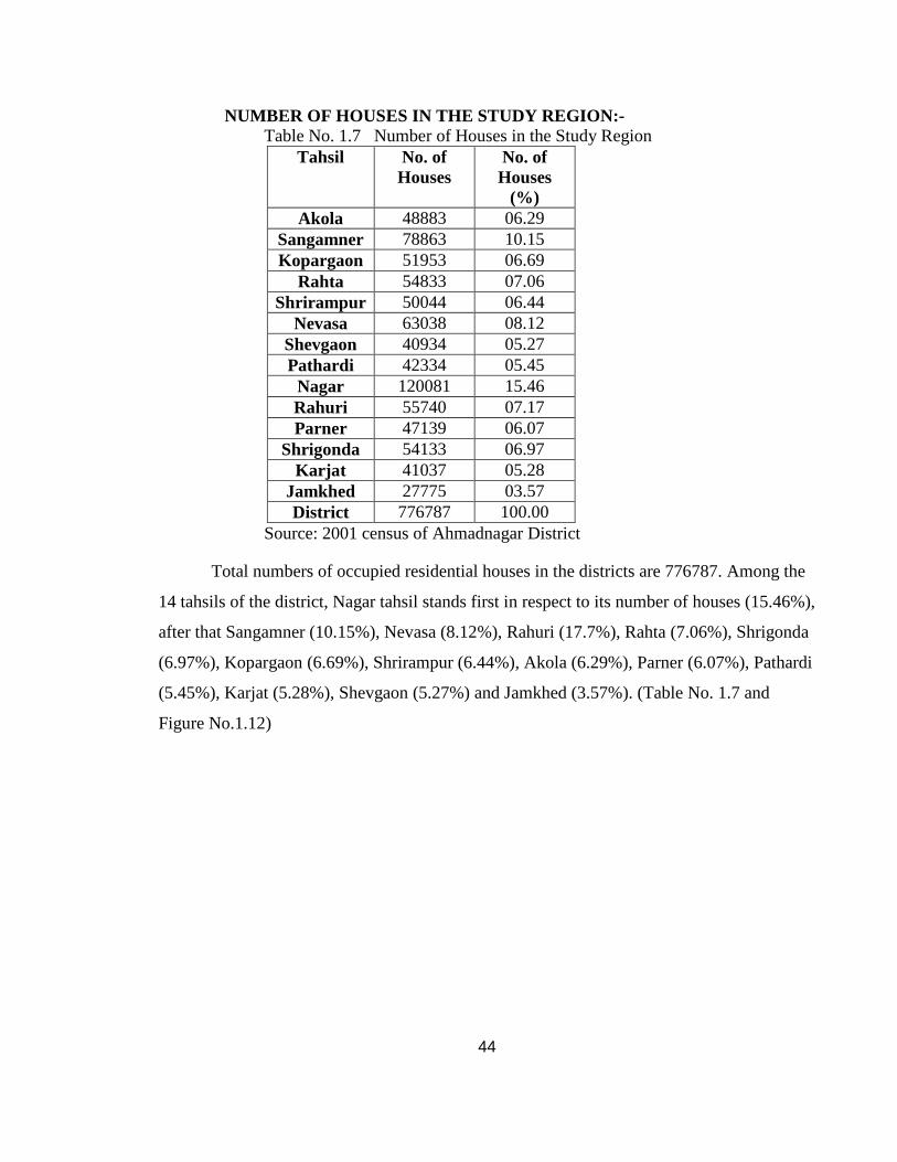
NUMBER OF HOUSES IN THE STUDY REGION:- Table No. 1.7 Number of Houses in the Study Region
Tahsil No. of Houses
No. of Houses
(%) Akola 48883 06.29
Sangamner 78863 10.15 Kopargaon 51953 06.69
Rahta 54833 07.06 Shrirampur 50044 06.44
Nevasa 63038 08.12 Shevgaon 40934 05.27 Pathardi 42334 05.45 Nagar 120081 15.46 Rahuri 55740 07.17 Parner 47139 06.07
Shrigonda 54133 06.97 Karjat 41037 05.28
Jamkhed 27775 03.57 District 776787 100.00
Source: 2001 census of Ahmadnagar District
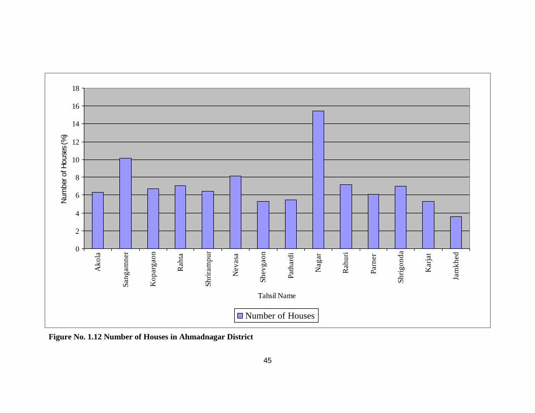
Total numbers of occupied residential houses in the districts are 776787. Among the
14 tahsils of the district, Nagar tahsil stands first in respect to its number of houses (15.46%),
after that Sangamner (10.15%), Nevasa (8.12%), Rahuri (17.7%), Rahta (7.06%), Shrigonda
(6.97%), Kopargaon (6.69%), Shrirampur (6.44%), Akola (6.29%), Parner (6.07%), Pathardi
(5.45%), Karjat (5.28%), Shevgaon (5.27%) and Jamkhed (3.57%). (Table No. 1.7 and
Figure No.1.12)
45
0
2
4
6
8
10
12
14
16
18A
kola
Sa
ng
am
ne
r
Ko
pa
rga
on
Ra
hta
Sh
rira
mp
ur
Ne
vasa
Sh
evg
ao
n
Pa
tha
rdi
Na
ga
r
Ra
hu
ri
Pa
rne
r
Sh
rigo
nd
a
Ka
rjat
Jam
khe
d
Tahsil Name
Num
ber o
f Hou
ses
(%)
Number of Houses
Figure No. 1.12 Number of Houses in Ahmadnagar District
46
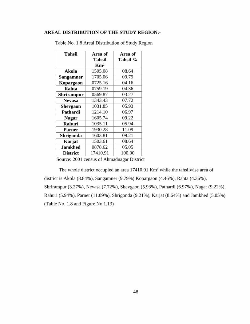
AREAL DISTRIBUTION OF THE STUDY REGION:-
Table No. 1.8 Areal Distribution of Study Region
Source: 2001 census of Ahmadnagar District
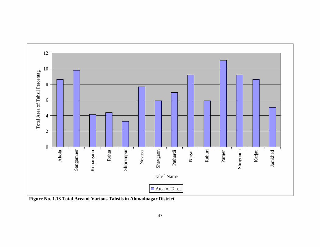
The whole district occupied an area 17410.91 Km² while the tahsilwise area of
district is Akola (8.84%), Sangamner (9.79%) Kopargaon (4.46%), Rahta (4.36%),
Shrirampur (3.27%), Nevasa (7.72%), Shevgaon (5.93%), Pathardi (6.97%), Nagar (9.22%),
Rahuri (5.94%), Parner (11.09%), Shrigonda (9.21%), Karjat (8.64%) and Jamkhed (5.05%).
(Table No. 1.8 and Figure No.1.13)
Tahsil Area of Tahsil Km²
Area of Tahsil %
Akola 1505.08 08.64 Sangamner 1705.06 09.79 Kopargaon 0725.16 04.16
Rahta 0759.19 04.36 Shrirampur 0569.87 03.27
Nevasa 1343.43 07.72 Shevgaon 1031.85 05.93 Pathardi 1214.10 06.97 Nagar 1605.74 09.22 Rahuri 1035.11 05.94 Parner 1930.28 11.09
Shrigonda 1603.81 09.21 Karjat 1503.61 08.64
Jamkhed 0878.62 05.05 District 17410.91 100.00
47
0
2
4
6
8
10
12A
kola
San
gam
ner
Kop
arga
on
Rah
ta
Shr
iram
pur
Nev
asa
She
vgao
n
Pat
hard
i
Nag
ar
Rah
uri
Par
ner
Shr
igon
da
Kar
jat
Jam
khed
Tahsil Name
Tot
al A
rea
of T
ahsi
l Per
cent
age
Area of Tahsil
Figure No. 1.13 Total Area of Various Tahsils in Ahmadnagar District
48
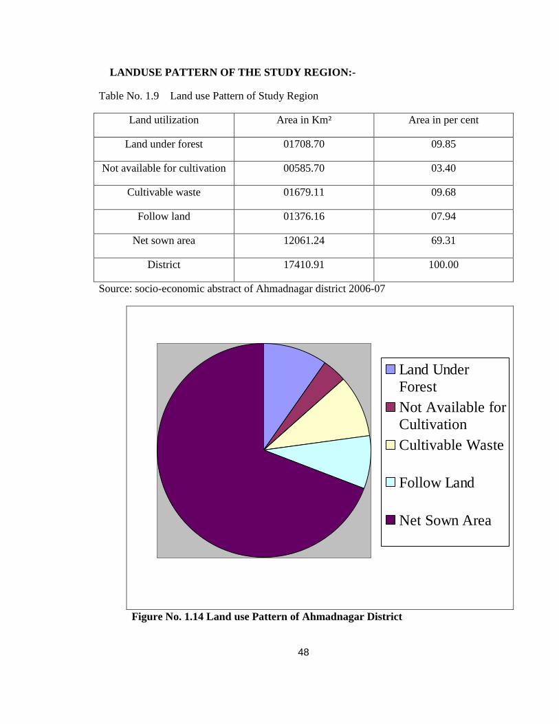
LANDUSE PATTERN OF THE STUDY REGION:-
Table No. 1.9 Land use Pattern of Study Region
Land utilization Area in Km² Area in per cent
Land under forest 01708.70 09.85
Not available for cultivation 00585.70 03.40
Cultivable waste 01679.11 09.68
Follow land 01376.16 07.94
Net sown area 12061.24 69.31
District 17410.91 100.00
Source: socio-economic abstract of Ahmadnagar district 2006-07
Land UnderForestNot Available forCultivationCultivable Waste
Follow Land
Net Sown Area
Figure No. 1.14 Land use Pattern of Ahmadnagar District
49
Nearly one-tenth of the total area in the district is under forest. Thus, in comparison
to the state as such, Ahmadnagar district is less forested. The forest in the district is of the
type “Southern Tropical Dry Deciduous”. They are scattered in sheltered pockets of spurs
and valleys situated mainly in Akola, Sangamner, Nagar, Shrigonda, Parner, Rahuri, and
Karjat tahsils. The species found in the forests are teak, neem, babul, sisoo, sandalwood etc.
Other species such as khair, hiwar, herkal, apta, bar etc. are also found in the forests.
However, the district gets revenue mainly from the minor forest products such as bamboo,
grass, tendu leaves and gums. These products are supplemented by agave, apta leaves,
wawding sitaphal etc. About 3.40 per cent of land is not available for cultivation. Cultivable
waste and follow n land is 9.68 per cent and 7.94 per cent respectively. The sown area of the
whole district is 69.31 per cent. In it Rice, Wheat, Jawar, Bajra, Sugarcane are the main
crops in the study region. (Table No. 1.9 and Figure No.1.14)
CROPPING PATTERN OF THE STUDY REGION:-
Table No. 1.10 Cropping Pattern of Study Region
Crops Per cent to total
Cereals 75.47
Pulses 06.32
Sugarcane 06.12
Vegetables & Fruits 02.83
Other crops 09.26
Source: socio-economic abstract of Ahmadnagar district 2006-07

50
Cereals
Pulses
Sugarcane
Vegetable & Fruits
Other crops
Figure No. 1.15 Cropping Pattern of Ahmadnagar District
Cropping pattern means the proportion of area under various crops at a point of time.
It changes in space and time. Agricultural land use is governed by the physical as well as
cultural and technological factors. Agriculture plays an important role in the economy of the
region.
The regional cropping pattern reveals that, it dominated by the cultivation of
cereals crops on the total cultivable land in the study area, percentage is almost 75.47. In the
cropping pattern other crops occupy second rank and share 9.26 per cent of total cultivable
land. The third rank was occupied by pulses nearly 6.32 per cent of total cultivable area.
Nearly 6.12 per cent of total cultivable area was under sugarcane.Vegetable and Fruits rank
fifth and occupy nearly 2.83 per cent of the area. (Table No. 1.10 and Figure No.1.15)
51
SOCIAL AMENITIES OF THE STUDY REGION:-
Social amenities plays secondary role in the type of village (compact type or
concentrated settlement). Higher order social amenities show the high population size of the
village and it affects on size and spacing of the village e.g. High school, Junior college,
Hospital, Dispensary, post services, Bus stop or Railway station etc. In addition, these
facilities are the functions of rural settlement, which give the boost to rural market center.
1. EDUCATION FACILITY OF THE STUDY REGION:-
The Ahmadnagar district is enrich with educational facilities. It holds from Play
group or Nursery to Medical, Engineering and Agricultural colleges up to the date
30/09/2006. The district contain 3262 Primary School,806 High School,152 Junior college
and 41 colleges i.e.4261 educational institutions play an important role in the literacy and
development of the study region. At that time 831967 student were enrolled in various
institutions. Out of them 425785 are in Primary School, 294717are in High School, 71051
are in Junior College and 40414 are in colleges.
2. MEDICAL FACILITY OF THE STUDY REGION:-
There are many types of medical facilities available in the study area such as
Dispensary, Hospital, Maternity & Child welfare, Primary health center and Primary health
sub center.
Ahmadnagar district is enrich with medical facilities. There are 692 various types of
medical facilities available in the district. Out of them 29 are Dispensary, 12 Hospitals, 29
Maternity & Child welfare centers, 96 Primary health center and 555 are the Primary health
sub centers provided by the government in 2006-07.
3. POST, TELEGRAPH AND TELEPHONE FACILITY:-
Post, Telegraph and telephone are important channels of communication. The
communication which is runs from ancient period to modern period always changes its way.
There are 750 post offices and telegraph centres in study region out of it 665 are post offices
and 85 are telegraph offices in 2006-07. The district contains 205346 telephones which

52
affects the telegraph facility i.e. telegraph facility reduced day by day also it slightly affects
on post facility.
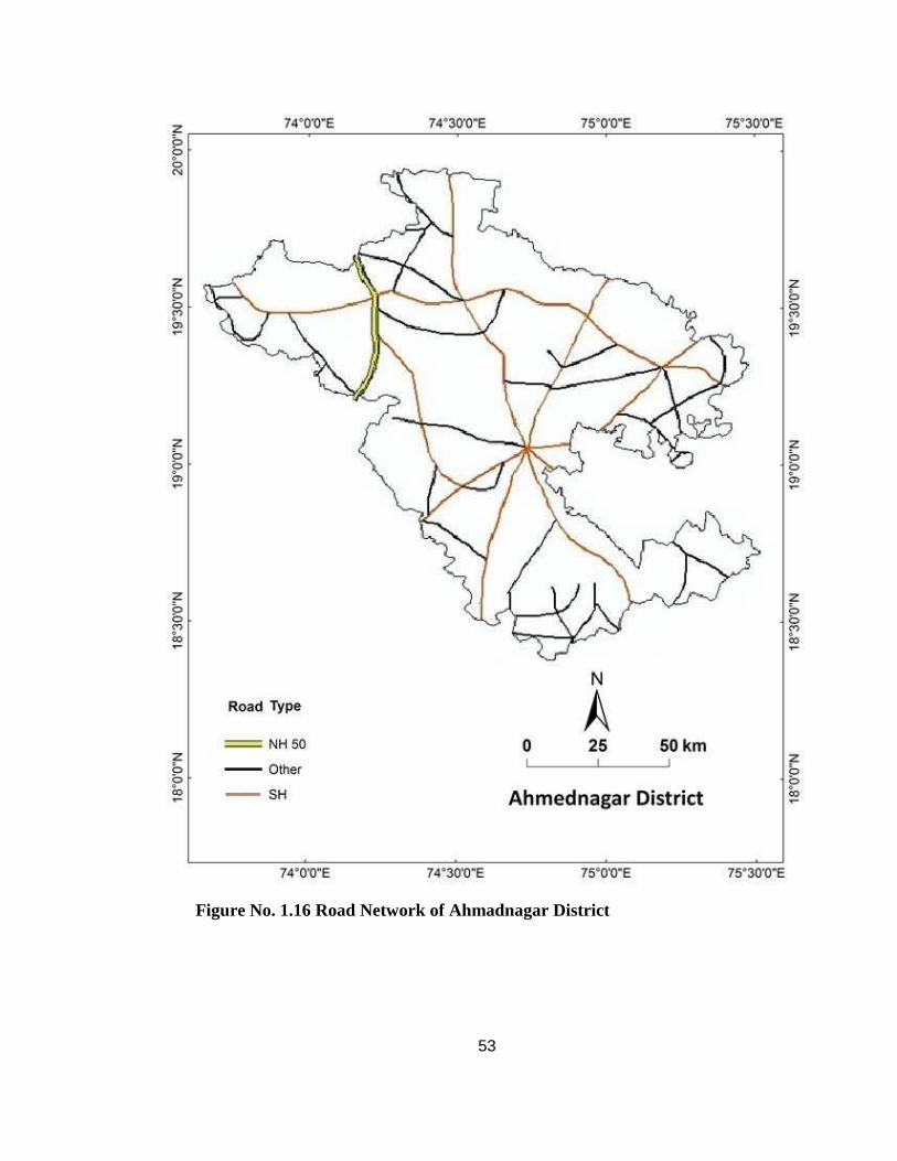
4. TRANSPORTATION FACILITY OF STUDY REGION:-
The study region enjoys comparative good system of transportation facility mainly of
private and government vehicles including railways. In 2001 in study region the road length
was 13594 Km. (Figure No. 1.16) and rail route length was 197 Km. (Figure No. 1.17).
There are 439853 passenger carrier and 67253 goods carrier.
53
Figure No. 1.16 Road Network of Ahmadnagar District

54
Figure No. 1.17 Railway Network of Ahmadnagar District
55
REFERANCES: -
1) Gazetteer of “The Bombay Presidency”, Ahmadnagar District Volume XVII (2003) P.P.
1 – 15
2) Census of India (1991), “ District Census Handbook of Ahmadnagar”, Published by the
Director of Census operations Govt. Printing Press Mumbai P.P. 18 -20
3) Census of India (1991), “ District Census Handbook of Ahmadnagar”, Published by the
Director of Census operations Govt. Printing Press Mumbai P.P. 26 -30
4) Census C. D. of Maharashtra and Goa state (2001).
5) Socio-economic Abstract of Ahmadnagar District 2006-07 P.P. 7
6) Socio-economic Abstract of Ahmadnagar District 2006-07 P.P. 12
7) Socio-economic Abstract of Ahmadnagar District 2006-07 P.P. 14
8) Socio-economic Abstract of Ahmadnagar District 2006-07 P.P. 35 - 36
9) Kulkarni Suyog Prakash (2004), “Distribution of settlements in North Ahmadnagar
District : A Geographical Analysis” , Unpublished M.A. Dissertation, Pune University
P.P. 9 - 16
10) Kulkarni Suyog Prakash (2004), “Distribution of settlements in North Ahmadnagar
District : A Geographical Analysis” , Unpublished M.A. Dissertation, Pune University
P.P. 18 – 27
11) Kulkarni Suyog Prakash (2004), “Distribution of settlements in North Ahmadnagar
District : A Geographical Analysis” , Unpublished M.A. Dissertation, Pune University
P.P. 29 – 35
12) Kulkarni Suyog Prakash (2008), “settlements Pattern in Godavari Valley, Kopargaon
Tahsil of Ahmadnagar District, Maharashtra State: A Spatial Analysis”, Unpublished
M.Phil. Dissertation, Tilak Maharashtra Vidyapeeth, Pune P.P. 12 – 20
13) Kumbhar Arjun (1997), “Rural Habitat”, Published Ph.D Thesis Shivaji University,
Kolhapur Sumeroo Prakashan Thane P.P. 3-8
56
14) Ghosh B.N. (1985), “Fundamentals of Population Geography”, Sterling Publisher Pvt.
Ltd. New Delhi.31 – 32
15) Chandana R. C. (1996), “A Geography of Population Concept, Determinants and
Patterns”, Kalyani Publisher New Delhi.
16) Mandal R.B. (2001), “Introduction to Rural Settlements”, Concept Publication Company
New Delhi.
17) Singh Sant Bahadur (1977), “ Rural Settlement Geography A Case Study of Sultanpur
District” , Uttar Bharat Bhoogol Parishad Gorakhapur Research Series No. 2 P.P. 1 -5
18) Yadav Shio Muni (1997), “Rural settlement Pattern A Case Study of Vaishali District,
Radha Publications New Delhi.
19) Sawant S.B. (1979), “Trends of Rural Transformation in Pune District”, Deccan
Geographer Vol. XCIII, P.P. 644 – 656
20) Husain Majid (1979), “Agricultural Geography” , Inter India Publication Delhi P.P. 80


![BIBLIOGRAPHY – CHAPTER 1shodhganga.inflibnet.ac.in/bitstream/10603/18801/15/16_references.pdf · BIBLIOGRAPHY – CHAPTER 1 [1] E.N. Gregory, ... microstructure and wear behaviour](https://img.pdfslide.us/doc/110x75/5b7917b07f8b9a31308cfd69/bibliography-chapter-bibliography-chapter-1-1-en-gregory-microstructure.jpg)