Embed Size (px)
Citation preview
Chapter 16Landforms Made by Waves and Wind
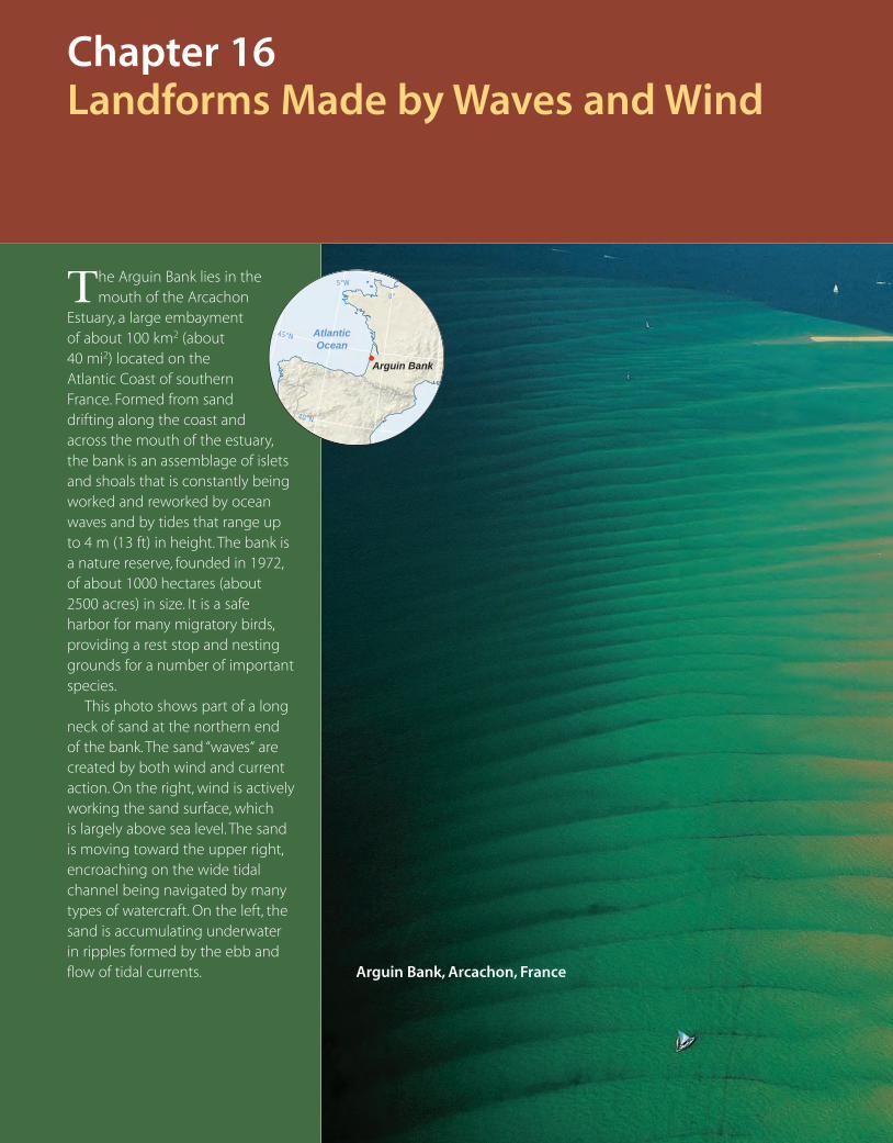
The Arguin Bank lies in the mouth of the Arcachon
Estuary, a large embayment of about 100 km2 (about 40 mi2) located on the Atlantic Coast of southern France. Formed from sand drifting along the coast and across the mouth of the estuary, the bank is an assemblage of islets and shoals that is constantly being worked and reworked by ocean waves and by tides that range up to 4 m (13 ft) in height. The bank is a nature reserve, founded in 1972, of about 1000 hectares (about 2500 acres) in size. It is a safe harbor for many migratory birds, providing a rest stop and nesting grounds for a number of important species.
This photo shows part of a long neck of sand at the northern end of the bank. The sand “waves“ are created by both wind and current action. On the right, wind is actively working the sand surface, which is largely above sea level. The sand is moving toward the upper right, encroaching on the wide tidal channel being navigated by many types of watercraft. On the left, the sand is accumulating underwater in ripples formed by the ebb and flow of tidal currents. Arguin Bank, Arcachon, France
Arguin Bank
AtlanticOcean
40°N
0°
5°W
45°N
c16LandformsMadeByWavesAndWind.indd 522 4/29/10 10:13:41 AM
Eye on Global Change • Global Change and Coastal Environments
The Work of Waves and TidesWAVES
MARINE SCARPS AND CLIFFS
BEACHES AND LITTORAL DRIFT
TIDAL CURRENTS
Types of CoastlinesRIA COASTS AND FIORD COASTS
BARRIER-ISLAND COASTS
DELTA COASTS
VOLCANO AND CORAL-REEF COASTS
FAULT COASTS
RAISED SHORELINES AND MARINE
TERRACES
Wind ActionEROSION BY WIND
DUST STORMS
Sand Dunes and LoessTYPES OF SAND DUNES
COASTAL FOREDUNES
LOESS
INDUCED DEFLATION
c16LandformsMadeByWavesAndWind.indd 523 4/29/10 10:14:46 AM
524
Global Change and Coastal EnvironmentsGlobal climate change over the remainder of the twenty-first century will have major impacts on coastal environments. The changes include increases in sea-surface temperature and sea level, decreases in sea-ice cover, and changes in salinity, wave climate, and ocean circulation.
What changes have already occurred? According to recent reports of the Intergovernmental Panel on Climate Change, sea level has risen about 15 cm since 1870. Most of this rise is due to thermal expansion of sea water in response to global warming of about 0.75°C (1.35°F) since 1906, but some is also due to the
melting of glaciers and ice caps. Arctic sea-ice cover is decreasing at a rate of about 3 percent per decade, with summer ice cover decreasing by about 7 percent per decade. Extreme weather events are increasing, including the number of heat waves, number of precipitation events leading to flooding, the extent of drought-affected regions, and the intensity and duration of tropi-cal storms.
What changes are in store? Between 1990 and 2100, global average surface temperature will increase between 1.7 and 6.4°C (3.1 and 10.5°F), depending on the scenario for future economic growth and usage of fossil fuels. Sea level will rise from present levels by about 21 cm to 47 cm (8.3 to 18.5 in.), again depending on the scenario. Snow and ice cover will continue to decrease, and mountain glaciers and ice caps will continue their retreat of the twentieth century. Tropical cyclone peak wind and peak precipita-tion intensities will increase, and El Niño extremes of flood and drought will be exaggerated.
These changes are bad news for coastal environments. Let’s begin with coastal erosion (Figure 16.1). Global warming will
ind creates landforms directly by moving sand and dust and indirectly by generating
waves that shape shorelines and coasts. How do waves form, and how do they move
sediment along shorelines? What distinctive landforms does wave action create? What types of
coastlines do we find around the globe? What kinds of materials does wind erode, transport,
and deposit? What types of sand dunes are there, and how do they form? These are some of the
questions we will answer in this chapter.
W
Landforms Made by Waves and Wind
increase the frequency of high winds and heavy precipitation events, amplifying the effects of severe coastal storms. More frequent and longer El Niños will increase the severity and frequency of Pacific storms, leading to increased sea-cliff erosion along Southern Cali-fornia’s south- and southwest-facing coastlines. During La Niña events, Atlantic hurricane frequency and intensity will increase with increased risk of damage to structures and coastal populations.
How will sea-level rise impact coastlines? Over the past 100 years or so, about 70 percent of sandy shorelines have retreated and 10 percent have advanced. The long-term effect of sea level is to push beaches, salt marshes, and estuaries landward (Figure 16.2). Beaches disappear and are replaced by sea walls. Salt marshes are drained to reduce inland flooding. Estuaries become shallower and more saline. In this way, the most productive areas of the coast are squeezed between a rising ocean and a water’s edge that is increasingly defended.
Sea-level rise will not be uniform. Modifying factors of waves, currents, tides, and offshore topography can act to magnify the rise, depending on the location. Some models predict doubled rates of sea-level rise for portions of the eastern United States, North Ameri-can Pacific coast, and the western North American arctic shoreline.
Land subsidence is a contributing factor to the impact of sea-level rise. Many coastlines are fed by rivers that have now been dammed, often many times, which reduces the amount of fine sediment brought to the coast. Without new sediment, coastal wet-lands slowly sink as the older sediment that supports them com-pacts. This subsidence increases the effects of sea-level rise.
Rising sea level and increasing frequency
and severity of storms will heighten future
coastal erosion. Coastal wetlands will
decrease in area and in quality. Warming will stress coral reefs and
speed arctic shoreline recession.
EYE O
N G
LOB
AL C
HA
NG
E
c16LandformsMadeByWavesAndWind.indd 524 4/29/10 10:15:14 AM
Global Change and Coastal Environments 525
Delta coasts are especially sensitive to sediment starvation and subsidence. Here, rates of subsidence can reach 2 cm/yr (0.8 in./yr). The Mississippi has lost about half of its natural sediment load, and sediment transport by such rivers as the Nile and Indus has been reduced by 95 percent.
According to recent estimates, sea-level rise and subsidence could cause the loss of more than 22 percent of the world’s coastal wetlands by the year 2100. Coupled with losses directly related to human activity, coastal wetlands could decrease by 30 percent or more, with major impacts on commercially important fish and shellfish populations.
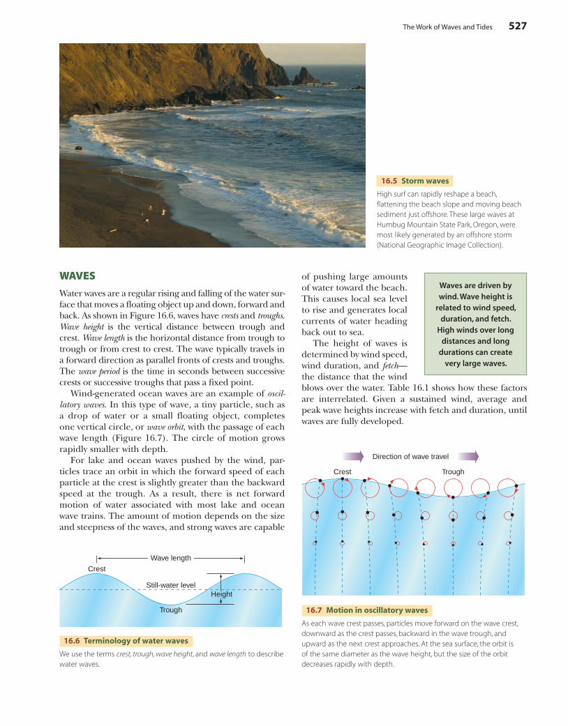
Coral reefs, like coastal wetlands, perform important ecological functions. They are highly biodiverse. They also serve as protective barriers to coastlines against storm waves and surges. However, more than half of the total area of living coral reefs is thought to be threatened by human activities ranging from water pollution to coral mining. When stressed by a rise in temperature, many corals respond by “bleaching” (Figure 16.3). In this process, they expel the algae that live symbiotically inside their structures, leaving the coral without color. The bleaching may be temporary if the stress subsides, but if permanent, the corals die. Major episodes of coral bleaching have been associated with increased water temperatures during strong El Niños.
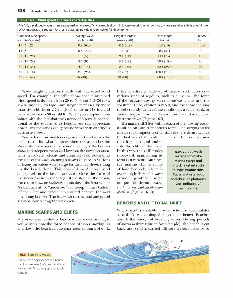
Many pristine stretches of arctic shoreline are threatened by global warming (Figure 16.4). As global temperatures rise, the shoreline is less protected by sea ice, frozen ground, and ground ice. Greater expanses of open sea allow larger waves to attack the coast. Moreover, global warming will be especially severe at high latitudes. Rapid coastal recession has already been reported along the Beaufort Sea.
It is apparent that global climate change will have major impacts on coastal environments, with very broad implications for ecosystems and natural resources. It will take careful management of our coastlines to reduce those impacts on both human and natural systems.
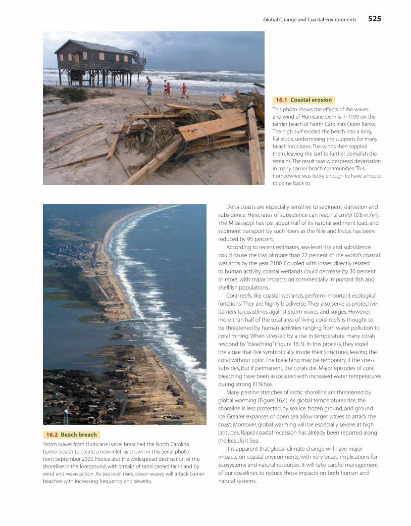
16.1 Coastal erosion
This photo shows the effects of the waves and wind of Hurricane Dennis in 1999 on the barrier beach of North Carolina’s Outer Banks. The high surf eroded the beach into a long, flat slope, undermining the supports for many beach structures. The winds then toppled them, leaving the surf to further demolish the remains. The result was widespread devastation in many barrier beach communities. This homeowner was lucky enough to have a house to come back to.
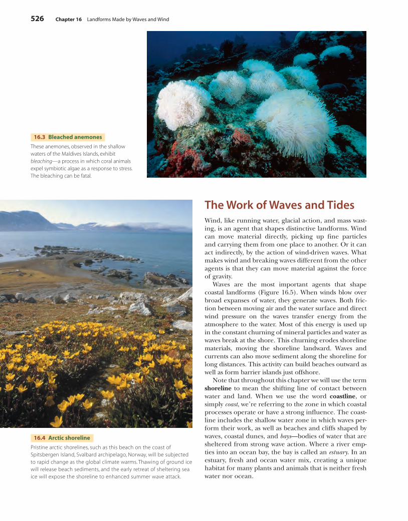
16.2 Beach breach
Storm waves from Hurricane Isabel breached the North Carolina barrier beach to create a new inlet, as shown in this aerial photo from September 2003. Notice also the widespread destruction of the shoreline in the foreground, with streaks of sand carried far inland by wind and wave action. As sea level rises, ocean waves will attack barrier beaches with increasing frequency and severity.
c16LandformsMadeByWavesAndWind.indd 525 4/29/10 10:15:14 AM
526 Chapter 16 Landforms Made by Waves and Wind
The Work of Waves and TidesWind, like running water, glacial action, and mass wast-ing, is an agent that shapes distinctive landforms. Wind can move material directly, picking up fine particles and carrying them from one place to another. Or it can act indirectly, by the action of wind-driven waves. What makes wind and breaking waves different from the other agents is that they can move material against the force of gravity.
Waves are the most important agents that shape coastal landforms (Figure 16.5). When winds blow over broad expanses of water, they generate waves. Both fric-tion between moving air and the water surface and direct wind pressure on the waves transfer energy from the atmosphere to the water. Most of this energy is used up in the constant churning of mineral particles and water as waves break at the shore. This churning erodes shoreline materials, moving the shoreline landward. Waves and currents can also move sediment along the shoreline for long distances. This activity can build beaches outward as well as form barrier islands just offshore.
Note that throughout this chapter we will use the term shoreline to mean the shifting line of contact between water and land. When we use the word coastline, or simply coast, we’re referring to the zone in which coastal processes operate or have a strong influence. The coast-line includes the shallow water zone in which waves per-form their work, as well as beaches and cliffs shaped by waves, coastal dunes, and bays—bodies of water that are sheltered from strong wave action. Where a river emp-ties into an ocean bay, the bay is called an estuary. In an estuary, fresh and ocean water mix, creating a unique habitat for many plants and animals that is neither fresh water nor ocean.
16.3 Bleached anemones
These anemones, observed in the shallow waters of the Maldives Islands, exhibit bleaching—a process in which coral animals expel symbiotic algae as a response to stress. The bleaching can be fatal.
16.4 Arctic shoreline
Pristine arctic shorelines, such as this beach on the coast of Spitsbergen Island, Svalbard archipelago, Norway, will be subjected to rapid change as the global climate warms. Thawing of ground ice will release beach sediments, and the early retreat of sheltering sea ice will expose the shoreline to enhanced summer wave attack.
c16LandformsMadeByWavesAndWind.indd 526 4/29/10 10:15:24 AM
The Work of Waves and Tides 527
16.5 Storm waves
High surf can rapidly reshape a beach, flattening the beach slope and moving beach sediment just offshore. These large waves at Humbug Mountain State Park, Oregon, were most likely generated by an offshore storm (National Geographic Image Collection).
Crest Trough
Direction of wave travel
16.7 Motion in oscillatory waves
As each wave crest passes, particles move forward on the wave crest, downward as the crest passes, backward in the wave trough, and upward as the next crest approaches. At the sea surface, the orbit is of the same diameter as the wave height, but the size of the orbit decreases rapidly with depth.
Trough
Crest
Still-water level
Wave length
Height
16.6 Terminology of water waves
We use the terms crest, trough, wave height, and wave length to describe water waves.
WAVES
Water waves are a regular rising and falling of the water sur-face that moves a floating object up and down, forward and back. As shown in Figure 16.6, waves have crests and troughs. Wave height is the vertical distance between trough and crest. Wave length is the horizontal distance from trough to trough or from crest to crest. The wave typically travels in a forward direction as parallel fronts of crests and troughs. The wave period is the time in seconds between successive crests or successive troughs that pass a fixed point.
Wind-generated ocean waves are an example of oscil-latory waves. In this type of wave, a tiny particle, such as a drop of water or a small floating object, completes one vertical circle, or wave orbit, with the passage of each wave length (Figure 16.7). The circle of motion grows rapidly smaller with depth.
For lake and ocean waves pushed by the wind, par-ticles trace an orbit in which the forward speed of each particle at the crest is slightly greater than the backward speed at the trough. As a result, there is net forward motion of water associated with most lake and ocean wave trains. The amount of motion depends on the size and steepness of the waves, and strong waves are capable
of pushing large amounts of water toward the beach. This causes local sea level to rise and generates local currents of water heading back out to sea.
The height of waves is determined by wind speed, wind duration, and fetch—the distance that the wind blows over the water. Table 16.1 shows how these factors are interrelated. Given a sustained wind, average and peak wave heights increase with fetch and duration, until waves are fully developed.
Waves are driven by wind. Wave height is
related to wind speed, duration, and fetch.
High winds over long distances and long
durations can create very large waves.
c16LandformsMadeByWavesAndWind.indd 527 4/29/10 10:15:35 AM
528 Chapter 16 Landforms Made by Waves and Wind
1
23
4 5 6
7 8
16.8 Breaking wave
As the wave approaches the beach (1–3), it steepens (4–5), and finally falls forward (6–7), rushing up the beach slope (8).
Wave height increases rapidly with increased wind speed. For example, the table shows that if sustained wind speed is doubled from 25 to 50 knots (13–26 m/s, 29–58 mi/hr), average wave height increases by more than fivefold, from 2.7 m (9 ft) to 15 m (48 ft), and peak waves reach 30 m (99 ft). When you coupled these values with the fact that the energy of a wave is propor-tional to the square of its height, you can appreciate how hurricane winds can generate waves with enormous destructive power.
Waves don’t lose much energy as they travel across the deep ocean. But what happens when a wave reaches the shore? As it reaches shallow water, the drag of the bottom slows and steepens the wave. However, the wave top main-tains its forward velocity and eventually falls down onto the face of the wave, creating a breaker (Figure 16.8). Tons of foamy turbulent water surge forward in a sheet, riding up the beach slope. This powerful swash moves sand and gravel on the beach landward. Once the force of the swash has been spent against the slope of the beach, the return flow, or backwash, pours down the beach. This “undercurrent” or “undertow” can sweep unwary bathers off their feet and carry them seaward beneath the next oncoming breaker. The backwash carries sand and gravel seaward, completing the wave cycle.
MARINE SCARPS AND CLIFFS
If you’ve ever visited a beach when waves are high, you’ve seen how the force of tons of water moving up and down the beach can do enormous amounts of work.
If the coastline is made up of weak or soft materials—various kinds of regolith, such as alluvium—the force of the forward-moving water alone easily cuts into the coastline. Here, erosion is rapid, and the shoreline may recede rapidly. Under these conditions, a steep bank, or marine scarp, will form and steadily erode as it is attacked by storm waves (Figure 16.9).
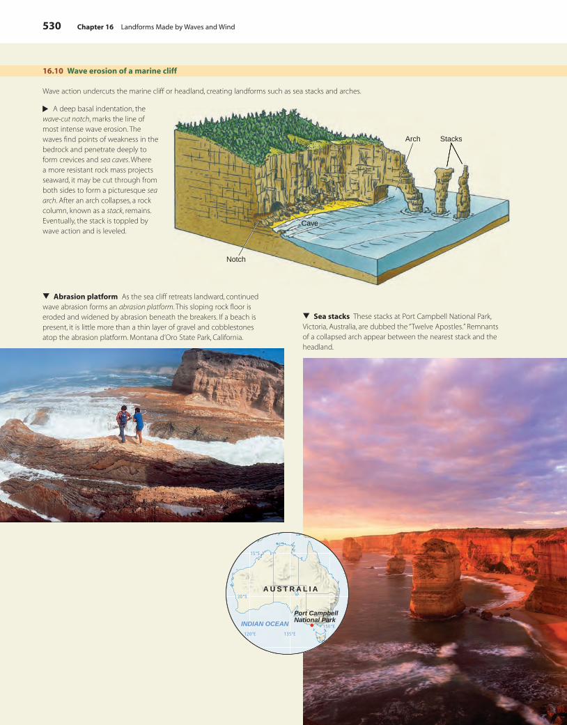
If a marine cliff lies within reach of the moving water, it will be hit with tremendous force. The surging water carries rock fragments of all sizes that are thrust against the bedrock of the cliff. The impact breaks away new rock fragments and under-cuts the cliff at the base. In this way, the cliff erodes shoreward, maintaining its form as it retreats. But since the marine cliff is made of hard bedrock, retreat is exceedingly slow. The wave erosion produces some unique landforms—caves, stacks, arches, and an abrasion platform (Figure 16.10).
BEACHES AND LITTORAL DRIFT
Where sand is available to wave action, it accumulates as a thick, wedge-shaped deposit, or beach. Beaches absorb the energy of breaking waves. During periods of storm activity (winter, for example), the beach is cut back, and sand is carried offshore a short distance by
Waves erode weak materials to make marine scarps and
attack resistant rocks to make marine cliffs. Caves, arches, stacks,
and abrasion platforms are landforms of
marine cliffs.
Table 16.1 Wind speed and wave characteristics
For fully developed waves given a sustained wind speed. Wind speed is shown in knots—nautical miles per hour, where a nautical mile is one minute
of longitude at the Equator. Fetch and duration are values required for full development.
Sustained wind speed,
knots (m/s, mi/hr)
Average wave
height, m (ft)
Height of largest
waves, m (ft)
Fetch length,
km (mi)
Duration,
hrs
10 (5, 12) 0.3 (0.9) 0.5 (1.8) 18 (10) 2.4
15 (8, 17) 0.8 (2.5) 1.5 (5) 63 (34) 6
20 (10, 23) 1.5 (5) 3.0 (10) 140 (75) 10
25 (13, 29) 2.7 (9) 5.5 (18) 300 (160) 16
30 (15, 35) 4.3 (14) 8.5 (28) 520 (280) 23
40 (21, 46) 8.5 (28) 17 (57) 1300 (710) 42
50 (26, 58) 15 (48) 30 (99) 2600 (1420) 69
c16LandformsMadeByWavesAndWind.indd 528 4/29/10 10:15:40 AM
The Work of Waves and Tides 529
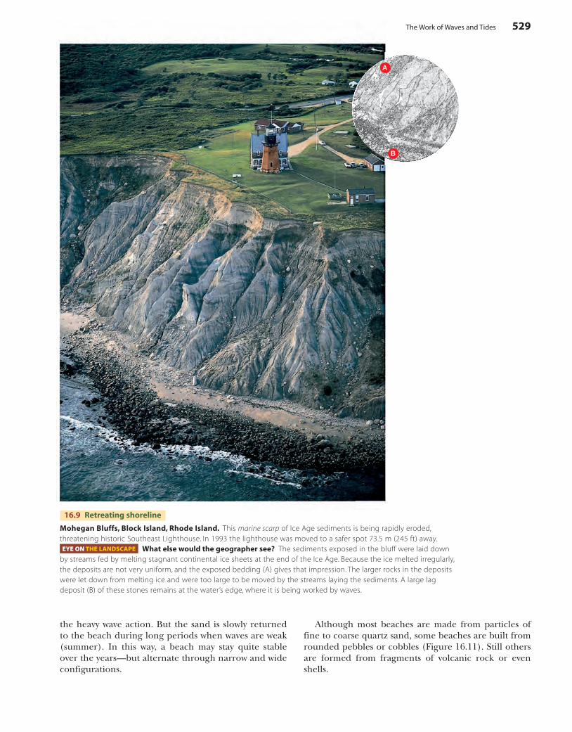
16.9 Retreating shoreline
Mohegan Bluffs, Block Island, Rhode Island. This marine scarp of Ice Age sediments is being rapidly eroded, threatening historic Southeast Lighthouse. In 1993 the lighthouse was moved to a safer spot 73.5 m (245 ft) away.EYE ON THE LANDSCAPE What else would the geographer see? The sediments exposed in the bluff were laid down
by streams fed by melting stagnant continental ice sheets at the end of the Ice Age. Because the ice melted irregularly, the deposits are not very uniform, and the exposed bedding (A) gives that impression. The larger rocks in the deposits were let down from melting ice and were too large to be moved by the streams laying the sediments. A large lag deposit (B) of these stones remains at the water’s edge, where it is being worked by waves.
A
B
the heavy wave action. But the sand is slowly returned to the beach during long periods when waves are weak (summer). In this way, a beach may stay quite stable over the years—but alternate through narrow and wide configurations.
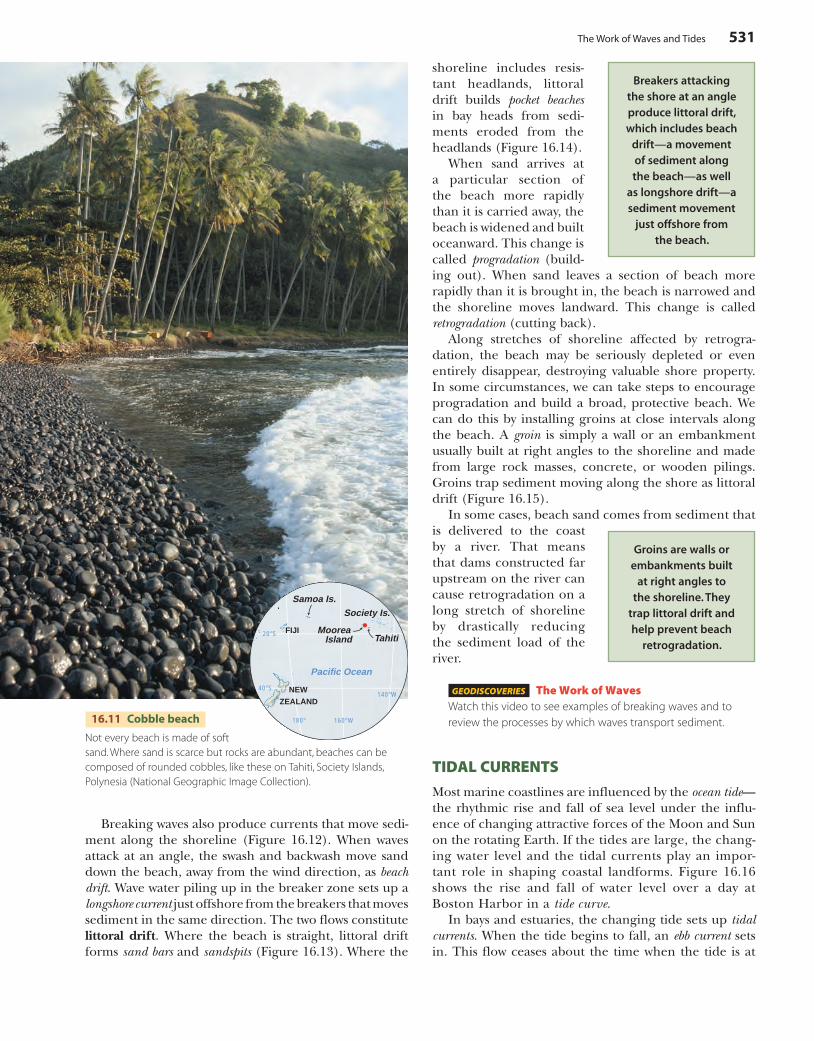
Although most beaches are made from particles of fine to coarse quartz sand, some beaches are built from rounded pebbles or cobbles (Figure 16.11). Still others are formed from fragments of volcanic rock or even shells.
c16LandformsMadeByWavesAndWind.indd 529 4/29/10 10:15:41 AM
530 Chapter 16 Landforms Made by Waves and Wind
16.10 Wave erosion of a marine cliff
Wave action undercuts the marine cliff or headland, creating landforms such as sea stacks and arches.
Arch Stacks
Notch
Cave
▲
A deep basal indentation, the wave-cut notch, marks the line of most intense wave erosion. The waves find points of weakness in the bedrock and penetrate deeply to form crevices and sea caves. Where a more resistant rock mass projects seaward, it may be cut through from both sides to form a picturesque sea arch. After an arch collapses, a rock column, known as a stack, remains. Eventually, the stack is toppled by wave action and is leveled.
▲
Sea stacks These stacks at Port Campbell National Park, Victoria, Australia, are dubbed the “Twelve Apostles.” Remnants of a collapsed arch appear between the nearest stack and the headland.
▲
Abrasion platform As the sea cliff retreats landward, continued wave abrasion forms an abrasion platform. This sloping rock floor is eroded and widened by abrasion beneath the breakers. If a beach is present, it is little more than a thin layer of gravel and cobblestones atop the abrasion platform. Montana d’Oro State Park, California.
15°S
120°E 135°E
150°E
30°S
INDIAN OCEAN
A U S T R A L I A
Port CampbellNational Park
c16LandformsMadeByWavesAndWind.indd 530 4/29/10 10:15:51 AM
The Work of Waves and Tides 531
16.11 Cobble beach
Not every beach is made of soft sand. Where sand is scarce but rocks are abundant, beaches can be composed of rounded cobbles, like these on Tahiti, Society Islands, Polynesia (National Geographic Image Collection).
shoreline includes resis-tant headlands, littoral drift builds pocket beachesin bay heads from sedi-ments eroded from the headlands (Figure 16.14).
When sand arrives at a particular section of the beach more rapidly than it is carried away, the beach is widened and built oceanward. This change is called progradation (build-ing out). When sand leaves a section of beach more rapidly than it is brought in, the beach is narrowed and the shoreline moves landward. This change is called retrogradation (cutting back).
Along stretches of shoreline affected by retrogra-dation, the beach may be seriously depleted or even entirely disappear, destroying valuable shore property. In some circumstances, we can take steps to encourage progradation and build a broad, protective beach. We can do this by installing groins at close intervals along the beach. A groin is simply a wall or an embankment usually built at right angles to the shoreline and made from large rock masses, concrete, or wooden pilings. Groins trap sediment moving along the shore as littoral drift (Figure 16.15).
In some cases, beach sand comes from sediment that is delivered to the coast by a river. That means that dams constructed far upstream on the river can cause retrogradation on a long stretch of shoreline by drastically reducing the sediment load of the river.
GEODISCOVERIES The Work of WavesWatch this video to see examples of breaking waves and to review the processes by which waves transport sediment.
TIDAL CURRENTS
Most marine coastlines are influenced by the ocean tide—the rhythmic rise and fall of sea level under the influ-ence of changing attractive forces of the Moon and Sun on the rotating Earth. If the tides are large, the chang-ing water level and the tidal currents play an impor-tant role in shaping coastal landforms. Figure 16.16 shows the rise and fall of water level over a day at Boston Harbor in a tide curve.
In bays and estuaries, the changing tide sets up tidal currents. When the tide begins to fall, an ebb current sets in. This flow ceases about the time when the tide is at
Groins are walls or embankments built
at right angles to the shoreline. They
trap littoral drift and help prevent beach
retrogradation.Tahiti
MooreaIsland
Samoa Is.Society Is.
180° 160°W
140°W
20°S
40°S
Pacific Ocean
NEW
ZEALAND
FIJI
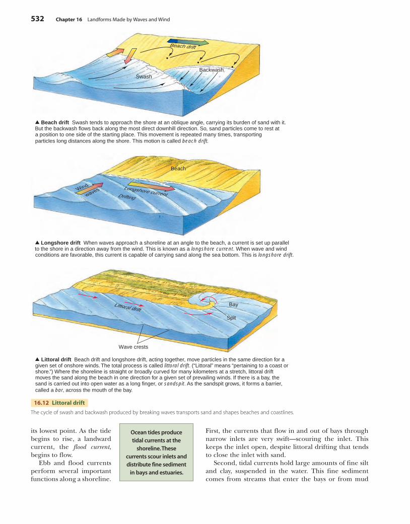
Breaking waves also produce currents that move sedi-ment along the shoreline (Figure 16.12). When waves attack at an angle, the swash and backwash move sand down the beach, away from the wind direction, as beach drift. Wave water piling up in the breaker zone sets up a longshore current just offshore from the breakers that moves sediment in the same direction. The two flows constitute littoral drift. Where the beach is straight, littoral drift forms sand bars and sandspits (Figure 16.13). Where the
Breakers attacking the shore at an angle produce littoral drift, which includes beach
drift—a movement of sediment along the beach—as well
as longshore drift—a sediment movement
just offshore from the beach.
c16LandformsMadeByWavesAndWind.indd 531 4/29/10 10:16:06 AM
532 Chapter 16 Landforms Made by Waves and Wind
Beach drift Swash tends to approach the shore at an oblique angle, carrying its burden of sand with it. But the backwash flows back along the most direct downhill direction. So, sand particles come to rest at a position to one side of the starting place. This movement is repeated many times, transporting particles long distances along the shore. This motion is called beach drift.
Longshore drift When waves approach a shoreline at an angle to the beach, a current is set up parallel to the shore in a direction away from the wind. This is known as a longshore current. When wave and windconditions are favorable, this current is capable of carrying sand along the sea bottom. This is longshore drift.
Beach drift
waves Longshore currentDrifting
Wind
SwashBackwash
Beach
Littoral drift Beach drift and longshore drift, acting together, move particles in the same direction for a given set of onshore winds. The total process is called littoral drift. (“Littoral” means “pertaining to a coast or shore.”) Where the shoreline is straight or broadly curved for many kilometers at a stretch, littoral drift moves the sand along the beach in one direction for a given set of prevailing winds. If there is a bay, the sand is carried out into open water as a long finger, or sandspit. As the sandspit grows, it forms a barrier, called a bar, across the mouth of the bay.
Littoral drift
Spit
Wave crests
Bay
16.12 Littoral drift
The cycle of swash and backwash produced by breaking waves transports sand and shapes beaches and coastlines.
First, the currents that flow in and out of bays through narrow inlets are very swift—scouring the inlet. This keeps the inlet open, despite littoral drifting that tends to close the inlet with sand.
Second, tidal currents hold large amounts of fine silt and clay, suspended in the water. This fine sediment comes from streams that enter the bays or from mud
its lowest point. As the tide begins to rise, a landward current, the flood current, begins to flow.
Ebb and flood currents perform several important functions along a shoreline.
Ocean tides produce tidal currents at the
shoreline. These currents scour inlets and distribute fine sediment
in bays and estuaries.
c16LandformsMadeByWavesAndWind.indd 532 4/29/10 10:16:12 AM
The Work of Waves and Tides 533
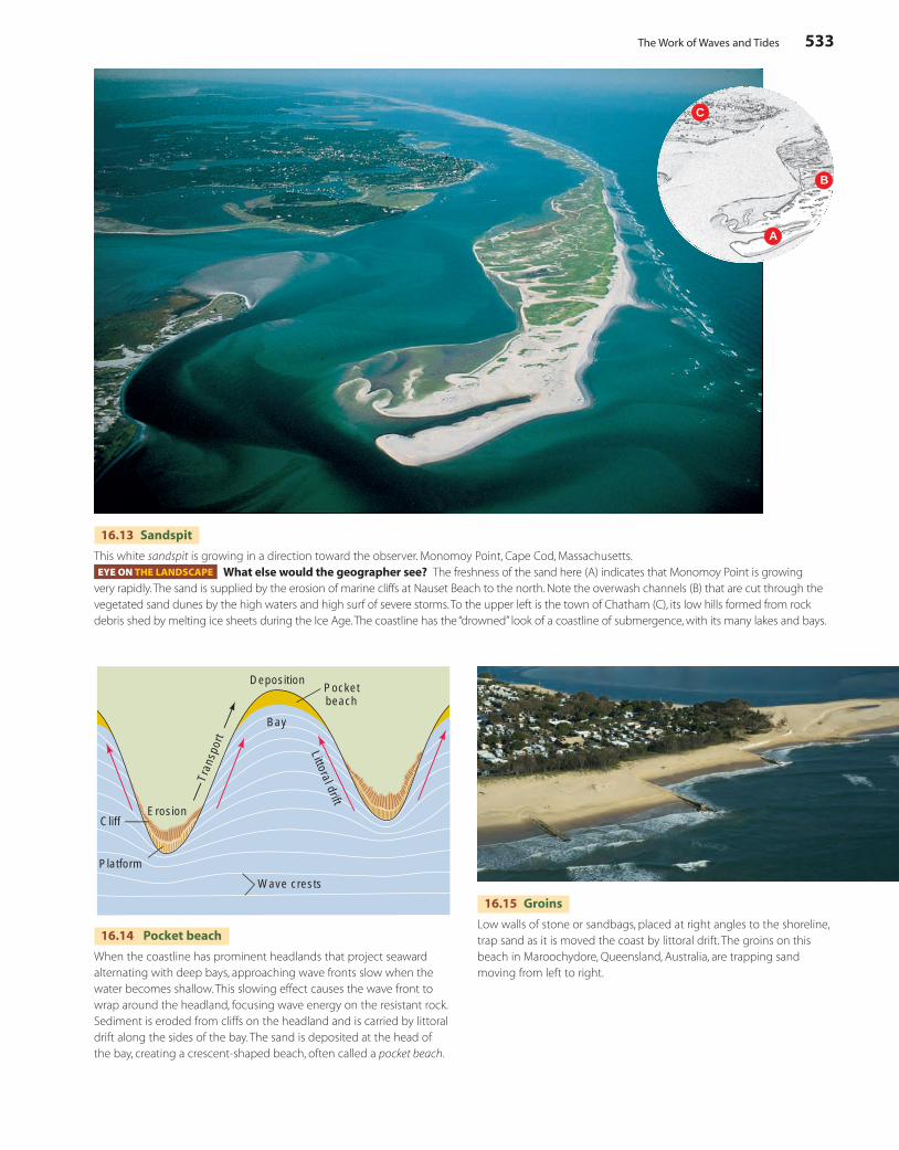
A
B
C
16.13 Sandspit
This white sandspit is growing in a direction toward the observer. Monomoy Point, Cape Cod, Massachusetts.EYE ON THE LANDSCAPE What else would the geographer see? The freshness of the sand here (A) indicates that Monomoy Point is growing
very rapidly. The sand is supplied by the erosion of marine cliffs at Nauset Beach to the north. Note the overwash channels (B) that are cut through the vegetated sand dunes by the high waters and high surf of severe storms. To the upper left is the town of Chatham (C), its low hills formed from rock debris shed by melting ice sheets during the Ice Age. The coastline has the “drowned” look of a coastline of submergence, with its many lakes and bays.
16.14 Pocket beach
When the coastline has prominent headlands that project seaward alternating with deep bays, approaching wave fronts slow when the water becomes shallow. This slowing effect causes the wave front to wrap around the headland, focusing wave energy on the resistant rock. Sediment is eroded from cliffs on the headland and is carried by littoral drift along the sides of the bay. The sand is deposited at the head of the bay, creating a crescent-shaped beach, often called a pocket beach.
Platform
Wave crests
CliffErosion
Tran
spor
t
Bay
Littoral drift
Pocketbeach
Deposition
16.15 Groins
Low walls of stone or sandbags, placed at right angles to the shoreline, trap sand as it is moved the coast by littoral drift. The groins on this beach in Maroochydore, Queensland, Australia, are trapping sand moving from left to right.
c16LandformsMadeByWavesAndWind.indd 533 4/29/10 10:16:16 AM
534 Chapter 16 Landforms Made by Waves and Wind
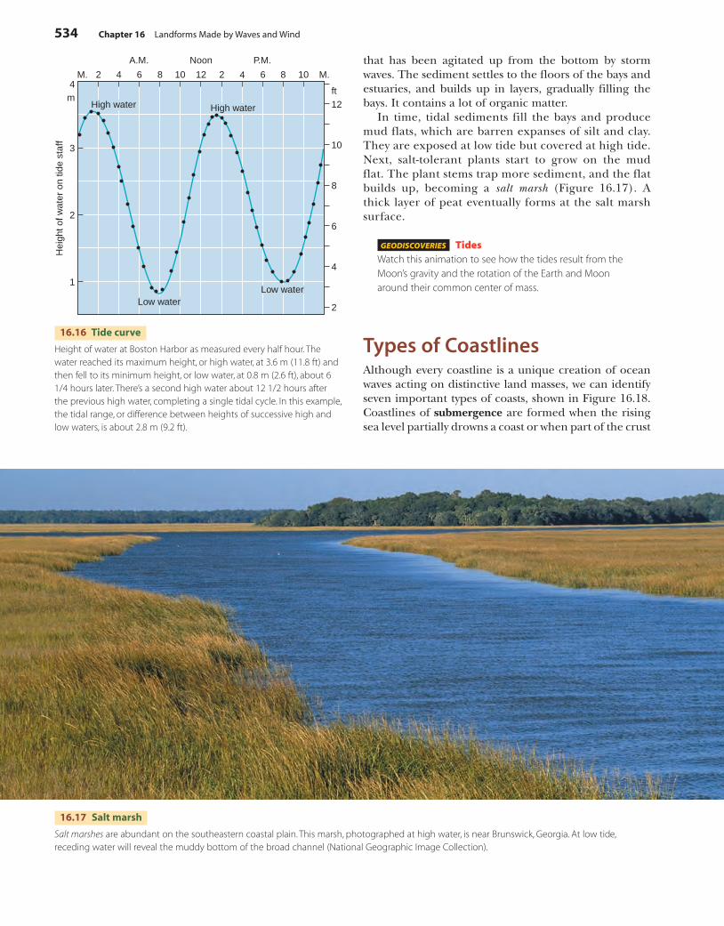
that has been agitated up from the bottom by storm waves. The sediment settles to the floors of the bays and estuaries, and builds up in layers, gradually filling the bays. It contains a lot of organic matter.
In time, tidal sediments fill the bays and produce mud flats, which are barren expanses of silt and clay. They are exposed at low tide but covered at high tide. Next, salt-tolerant plants start to grow on the mud flat. The plant stems trap more sediment, and the flat builds up, becoming a salt marsh (Figure 16.17). A thick layer of peat eventually forms at the salt marsh surface.
GEODISCOVERIES TidesWatch this animation to see how the tides result from the Moon’s gravity and the rotation of the Earth and Moon around their common center of mass.
Types of CoastlinesAlthough every coastline is a unique creation of ocean waves acting on distinctive land masses, we can identify seven important types of coasts, shown in Figure 16.18. Coastlines of submergence are formed when the rising sea level partially drowns a coast or when part of the crust
M. 2 4 6 8 10 12 2 4 6 8 10 M.
A.M. Noon P.M.
1
2
3
4m
2
4
6
8
10
12
Low waterLow water
High waterHigh water
Hei
ght o
f wat
er o
n tid
e st
aff
ft
16.16 Tide curve
Height of water at Boston Harbor as measured every half hour. The water reached its maximum height, or high water, at 3.6 m (11.8 ft) and then fell to its minimum height, or low water, at 0.8 m (2.6 ft), about 6 1/4 hours later. There’s a second high water about 12 1/2 hours after the previous high water, completing a single tidal cycle. In this example, the tidal range, or difference between heights of successive high and low waters, is about 2.8 m (9.2 ft).
16.17 Salt marsh
Salt marshes are abundant on the southeastern coastal plain. This marsh, photographed at high water, is near Brunswick, Georgia. At low tide, receding water will reveal the muddy bottom of the broad channel (National Geographic Image Collection).
c16LandformsMadeByWavesAndWind.indd 534 4/29/10 10:16:30 AM

Types of Coastlines 535
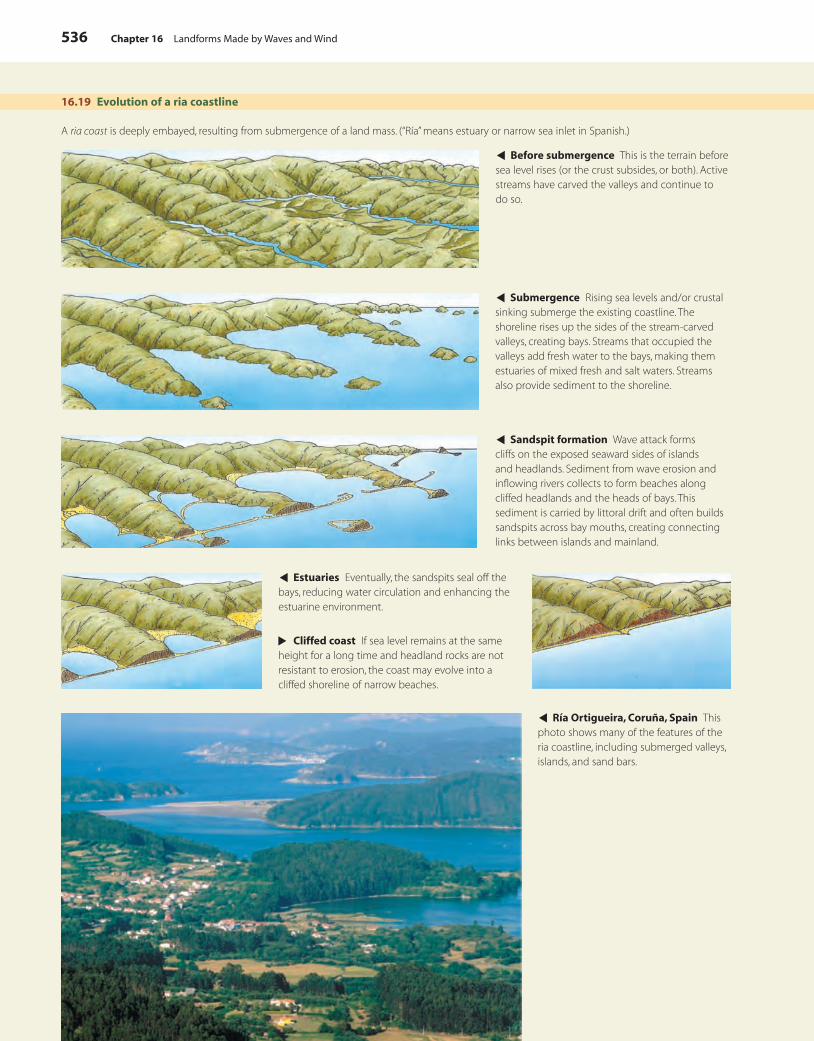
streams the valleys formerly contained, they become estuaries. Figure 16.19 describes the formation of a ria coast in more detail.
The fiord coast is similar to the ria coast (Figure 16.20). Steep-walled fiords are created from submerged glacial troughs rather than from submerged stream valleys, as in the case of ria coasts.
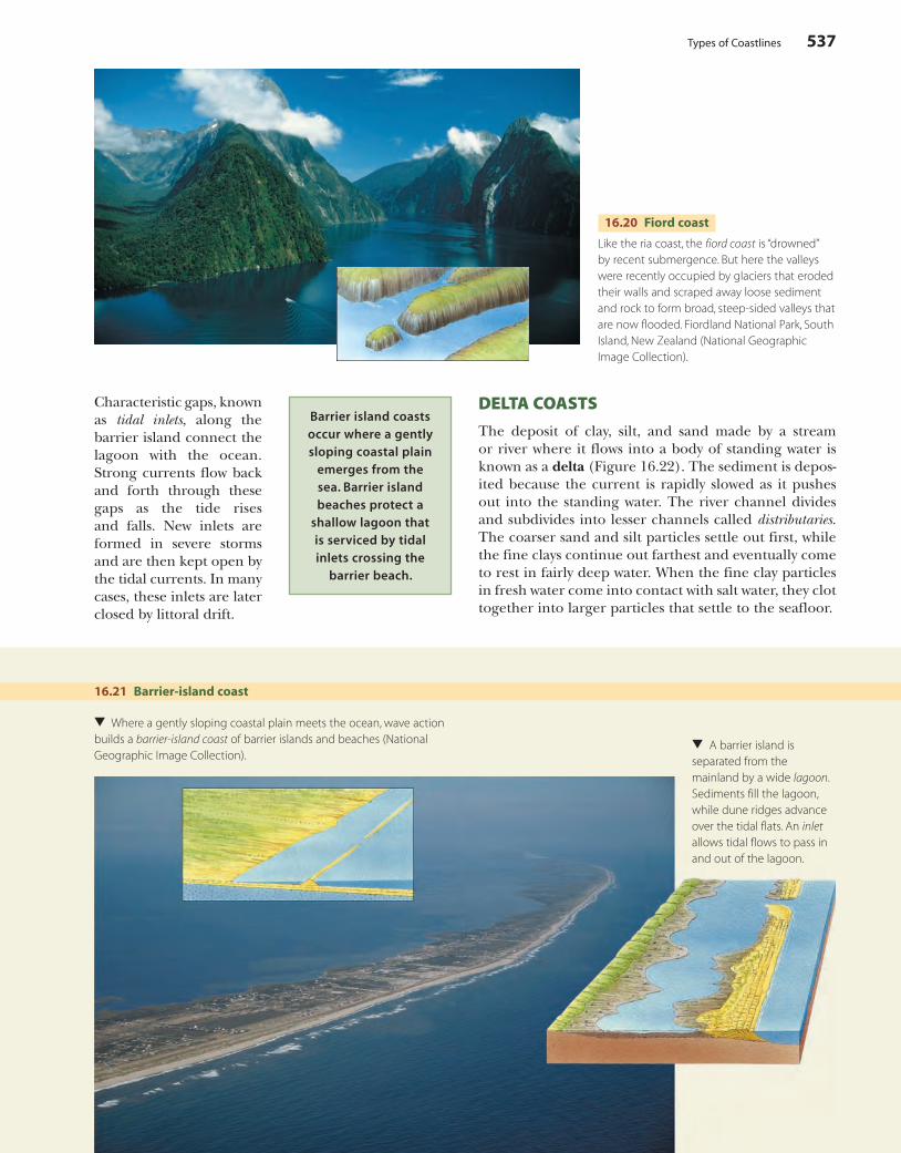
BARRIER-ISLAND COASTS
The barrier-island coast is associated with a recently emerged coastal plain (Figure 16.21). A barrier island is a low ridge of sand, lying a short distance from the coast, that is created by wave action and increases in height as coastal winds fortify the island with dunes. Much of the Atlantic and Gulf coast from New York to Texas is flanked by barrier islands.
Behind the barrier island is a lagoon—a broad expanse of shallow water in places largely filled with tidal deposits.
sinks. This group includes ria coasts and fiord coasts. Another group of coastlines are formed by the process of emergence, when submarine landforms are exposed by a falling of sea level or a rising of the crust. This group includes barrier-island coasts, volcano coasts, delta coasts, fault coasts, and coral-reef coasts.
RIA COASTS AND FIORD COASTS
Coastlines of submergence include ria coasts and fiord coasts. A ria coast is formed when a rise of sea level or a crustal sinking (or both) brings the shoreline to rest against the sides of river valleys previously carved by streams. Because the new embayments are fed fresh water from the
16.18 Seven types of coastlines
These sketches illustrate the important features of seven types of coastlines.
Ria coasts and fiord coasts result from
submergence of a land mass. Islands, bars,
estuaries, and bays are characteristic of these “drowned” coastlines.
Ria coast Fiord coast
Barrier-island coast Delta coast
Volcano coast (left) Coral-reef coast (right) Fault coast
c16LandformsMadeByWavesAndWind.indd 535 4/29/10 10:16:38 AM
536 Chapter 16 Landforms Made by Waves and Wind
16.19 Evolution of a ria coastline
A ria coast is deeply embayed, resulting from submergence of a land mass. (“Ría” means estuary or narrow sea inlet in Spanish.)
▲ Before submergence This is the terrain before sea level rises (or the crust subsides, or both). Active streams have carved the valleys and continue to do so.
▲ Submergence Rising sea levels and/or crustal sinking submerge the existing coastline. The shoreline rises up the sides of the stream-carved valleys, creating bays. Streams that occupied the valleys add fresh water to the bays, making them estuaries of mixed fresh and salt waters. Streams also provide sediment to the shoreline.
▲ Sandspit formation Wave attack forms cliffs on the exposed seaward sides of islands and headlands. Sediment from wave erosion and inflowing rivers collects to form beaches along cliffed headlands and the heads of bays. This sediment is carried by littoral drift and often builds sandspits across bay mouths, creating connecting links between islands and mainland.
▲ Estuaries Eventually, the sandspits seal off the bays, reducing water circulation and enhancing the estuarine environment.
▲
Cliffed coast If sea level remains at the same height for a long time and headland rocks are not resistant to erosion, the coast may evolve into a cliffed shoreline of narrow beaches.
▲ Ría Ortigueira, Coruña, Spain This photo shows many of the features of the ria coastline, including submerged valleys, islands, and sand bars.
c16LandformsMadeByWavesAndWind.indd 536 4/29/10 10:16:45 AM
Types of Coastlines 537
16.20 Fiord coast
Like the ria coast, the fiord coast is “drowned” by recent submergence. But here the valleys were recently occupied by glaciers that eroded their walls and scraped away loose sediment and rock to form broad, steep-sided valleys that are now flooded. Fiordland National Park, South Island, New Zealand (National Geographic Image Collection).
Characteristic gaps, known as tidal inlets, along the barrier island connect the lagoon with the ocean. Strong currents flow back and forth through these gaps as the tide rises and falls. New inlets are formed in severe storms and are then kept open by the tidal currents. In many cases, these inlets are later closed by littoral drift.
16.21 Barrier-island coast
▲
Where a gently sloping coastal plain meets the ocean, wave action builds a barrier-island coast of barrier islands and beaches (National Geographic Image Collection).
▲
A barrier island is separated from the mainland by a wide lagoon. Sediments fill the lagoon, while dune ridges advance over the tidal flats. An inlet allows tidal flows to pass in and out of the lagoon.
DELTA COASTS
The deposit of clay, silt, and sand made by a stream or river where it flows into a body of standing water is known as a delta (Figure 16.22). The sediment is depos-ited because the current is rapidly slowed as it pushes out into the standing water. The river channel divides and subdivides into lesser channels called distributaries. The coarser sand and silt particles settle out first, while the fine clays continue out farthest and eventually come to rest in fairly deep water. When the fine clay particles in fresh water come into contact with salt water, they clot together into larger particles that settle to the seafloor.
Barrier island coasts occur where a gently sloping coastal plain
emerges from the sea. Barrier island beaches protect a
shallow lagoon that is serviced by tidal inlets crossing the
barrier beach.
c16LandformsMadeByWavesAndWind.indd 537 4/29/10 10:16:54 AM
538 Chapter 16 Landforms Made by Waves and Wind
VOLCANO AND CORAL-REEF COASTS
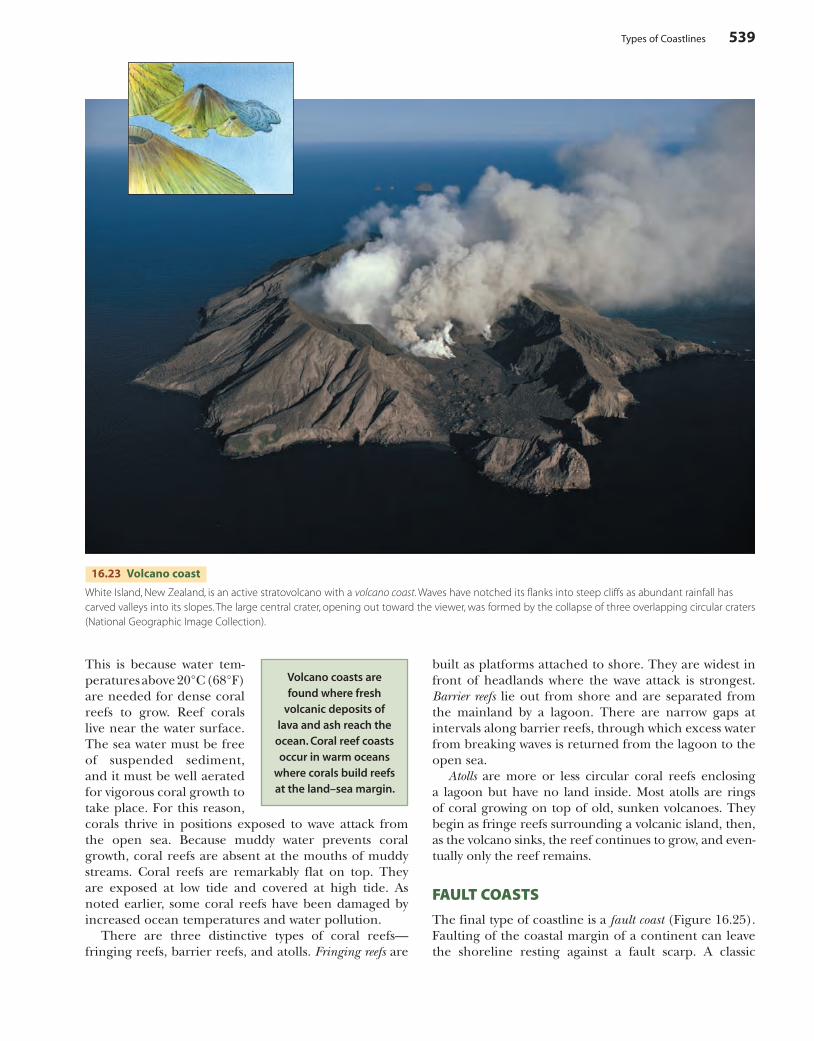
Volcano coasts arise where volcanic deposits—lava and ash—flow from active volcanoes into the ocean (Figure 16.23). Wave action erodes the fresh deposits, creating low cliffs. Beaches are typically narrow, steep, and composed of fine particles of the extrusive rock.
Coral-reef coasts are unique because the new land is made by organisms—corals and algae. Growing together, these organisms secrete rock-like deposits of carbonate minerals, called coral reefs. As coral colonies die, new ones are built on them, accumulating as limestone. Coral fragments are torn free by wave attack, and the pulverized fragments accumulate as sand beaches.
We find coral-reef coasts in warm tropical and equato-rial waters between lat. 30° N and 25° S (Figure 16.24).
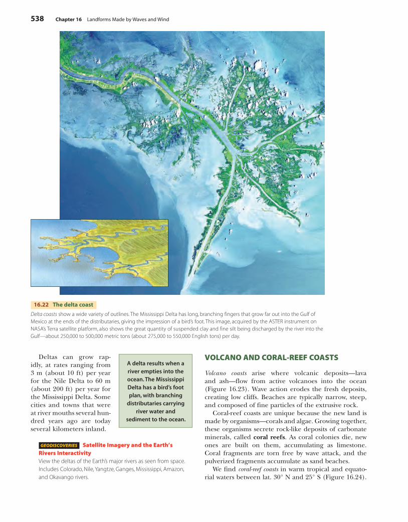
Deltas can grow rap-idly, at rates ranging from 3 m (about 10 ft) per year for the Nile Delta to 60 m (about 200 ft) per year for the Mississippi Delta. Some cities and towns that were at river mouths several hun-dred years ago are today several kilometers inland.
GEODISCOVERIES Satellite Imagery and the Earth’s Rivers InteractivityView the deltas of the Earth’s major rivers as seen from space. Includes Colorado, Nile, Yangtze, Ganges, Mississippi, Amazon, and Okavango rivers.
16.22 The delta coast
Delta coasts show a wide variety of outlines. The Mississippi Delta has long, branching fingers that grow far out into the Gulf of Mexico at the ends of the distributaries, giving the impression of a bird’s foot. This image, acquired by the ASTER instrument on NASA’s Terra satellite platform, also shows the great quantity of suspended clay and fine silt being discharged by the river into the Gulf—about 250,000 to 500,000 metric tons (about 275,000 to 550,000 English tons) per day.
A delta results when a river empties into the ocean. The Mississippi Delta has a bird’s foot plan, with branching
distributaries carrying river water and
sediment to the ocean.
c16LandformsMadeByWavesAndWind.indd 538 4/29/10 10:17:05 AM
Types of Coastlines 539
This is because water tem-peratures above 20°C (68°F) are needed for dense coral reefs to grow. Reef corals live near the water surface. The sea water must be free of suspended sediment, and it must be well aerated for vigorous coral growth to take place. For this reason, corals thrive in positions exposed to wave attack from the open sea. Because muddy water prevents coral growth, coral reefs are absent at the mouths of muddy streams. Coral reefs are remarkably flat on top. They are exposed at low tide and covered at high tide. As noted earlier, some coral reefs have been damaged by increased ocean temperatures and water pollution.
There are three distinctive types of coral reefs—fringing reefs, barrier reefs, and atolls. Fringing reefs are
built as platforms attached to shore. They are widest in front of headlands where the wave attack is strongest. Barrier reefs lie out from shore and are separated from the mainland by a lagoon. There are narrow gaps at intervals along barrier reefs, through which excess water from breaking waves is returned from the lagoon to the open sea.
Atolls are more or less circular coral reefs enclosing a lagoon but have no land inside. Most atolls are rings of coral growing on top of old, sunken volcanoes. They begin as fringe reefs surrounding a volcanic island, then, as the volcano sinks, the reef continues to grow, and even-tually only the reef remains.
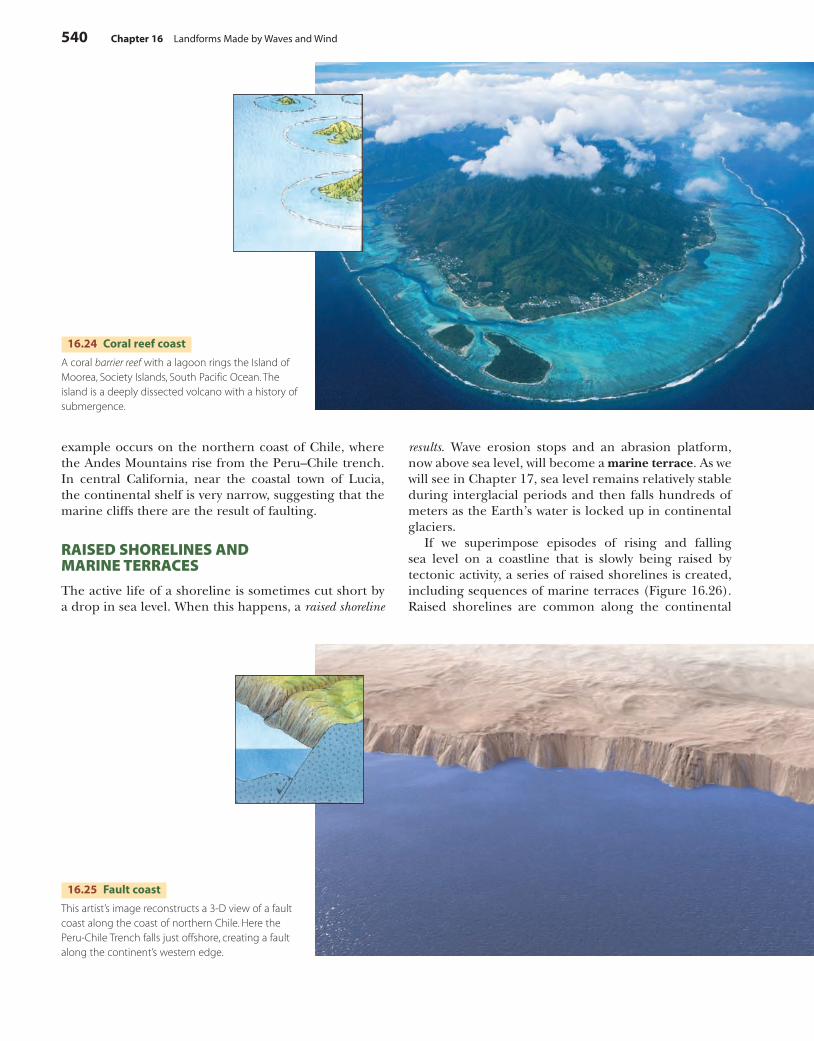
FAULT COASTS
The final type of coastline is a fault coast (Figure 16.25). Faulting of the coastal margin of a continent can leave the shoreline resting against a fault scarp. A classic
16.23 Volcano coast
White Island, New Zealand, is an active stratovolcano with a volcano coast. Waves have notched its flanks into steep cliffs as abundant rainfall has carved valleys into its slopes. The large central crater, opening out toward the viewer, was formed by the collapse of three overlapping circular craters (National Geographic Image Collection).
Volcano coasts are found where fresh
volcanic deposits of lava and ash reach the
ocean. Coral reef coasts occur in warm oceans
where corals build reefs at the land–sea margin.
c16LandformsMadeByWavesAndWind.indd 539 4/29/10 10:17:38 AM
540 Chapter 16 Landforms Made by Waves and Wind
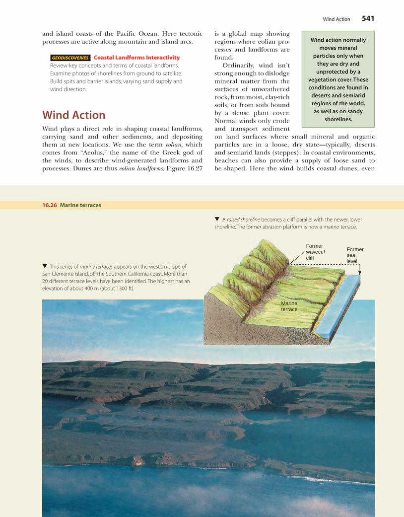
results. Wave erosion stops and an abrasion platform, now above sea level, will become a marine terrace. As we will see in Chapter 17, sea level remains relatively stable during interglacial periods and then falls hundreds of meters as the Earth’s water is locked up in continental glaciers.
If we superimpose episodes of rising and falling sea level on a coastline that is slowly being raised by tectonic activity, a series of raised shorelines is created, including sequences of marine terraces (Figure 16.26). Raised shorelines are common along the continental
example occurs on the northern coast of Chile, where the Andes Mountains rise from the Peru–Chile trench. In central California, near the coastal town of Lucia, the continental shelf is very narrow, suggesting that the marine cliffs there are the result of faulting.
RAISED SHORELINES AND MARINE TERRACES
The active life of a shoreline is sometimes cut short by a drop in sea level. When this happens, a raised shoreline
16.24 Coral reef coast
A coral barrier reef with a lagoon rings the Island of Moorea, Society Islands, South Pacific Ocean. The island is a deeply dissected volcano with a history of submergence.
16.25 Fault coast
This artist’s image reconstructs a 3-D view of a fault coast along the coast of northern Chile. Here the Peru-Chile Trench falls just offshore, creating a fault along the continent’s western edge.
c16LandformsMadeByWavesAndWind.indd 540 4/29/10 10:17:46 AM
Wind Action 541
MarMarMarMarMarMararMarMarMarMaMarMararMaMarMaMarMaMarMarMarMaarMaMaMMMMarrrMMMMMMMMMaarMMMMM ininininininnninininininninnininnininininnninininnneeeeeeeeeeeeeeeeeeeeetertertetertertertertertertererereetertertertertertertertererterterterererracracracracracracracracracracacracracracracacracracaccacccracracraccracracracraccceeeeeeeeeeeeeeeeeeeeeeeeeeeee
Formersealevel
Formerwavecutcliffcliff
16.26 Marine terraces
▲
This series of marine terraces appears on the western slope of San Clemente Island, off the Southern California coast. More than 20 different terrace levels have been identified. The highest has an elevation of about 400 m (about 1300 ft).
▲
A raised shoreline becomes a cliff parallel with the newer, lower shoreline. The former abrasion platform is now a marine terrace.
and island coasts of the Pacific Ocean. Here tectonic processes are active along mountain and island arcs.
GEODISCOVERIES Coastal Landforms InteractivityReview key concepts and terms of coastal landforms. Examine photos of shorelines from ground to satellite. Build spits and barrier islands, varying sand supply and wind direction.
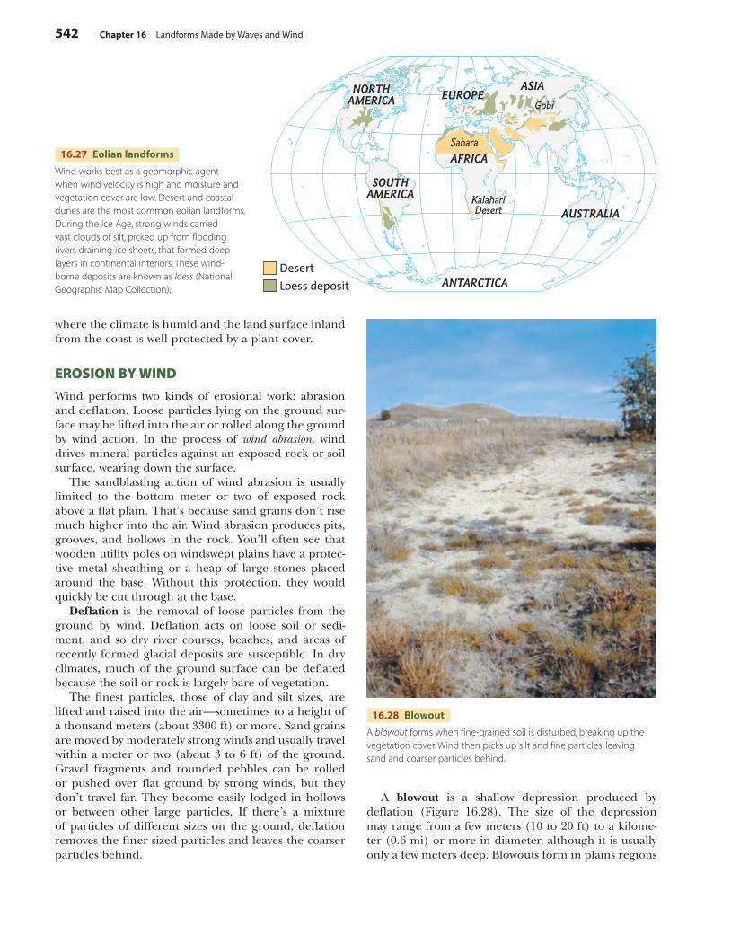
Wind ActionWind plays a direct role in shaping coastal landforms, carrying sand and other sediments, and depositing them at new locations. We use the term eolian, which comes from “Aeolus,” the name of the Greek god of the winds, to describe wind-generated landforms and processes. Dunes are thus eolian landforms. Figure 16.27
is a global map showing regions where eolian pro-cesses and landforms are found.
Ordinarily, wind isn’t strong enough to dislodge mineral matter from the surfaces of unweathered rock, from moist, clay-rich soils, or from soils bound by a dense plant cover. Normal winds only erode and transport sediment on land surfaces where small mineral and organic particles are in a loose, dry state—typically, deserts and semiarid lands (steppes). In coastal environments, beaches can also provide a supply of loose sand to be shaped. Here the wind builds coastal dunes, even
Wind action normally moves mineral
particles only when they are dry and unprotected by a
vegetation cover. These conditions are found in
deserts and semiarid regions of the world, as well as on sandy
shorelines.
c16LandformsMadeByWavesAndWind.indd 541 4/29/10 10:17:56 AM
542 Chapter 16 Landforms Made by Waves and Wind
where the climate is humid and the land surface inland from the coast is well protected by a plant cover.
EROSION BY WIND
Wind performs two kinds of erosional work: abrasion and deflation. Loose particles lying on the ground sur-face may be lifted into the air or rolled along the ground by wind action. In the process of wind abrasion, wind drives mineral particles against an exposed rock or soil surface, wearing down the surface.
The sandblasting action of wind abrasion is usually limited to the bottom meter or two of exposed rock above a flat plain. That’s because sand grains don’t rise much higher into the air. Wind abrasion produces pits, grooves, and hollows in the rock. You’ll often see that wooden utility poles on windswept plains have a protec-tive metal sheathing or a heap of large stones placed around the base. Without this protection, they would quickly be cut through at the base.
Deflation is the removal of loose particles from the ground by wind. Deflation acts on loose soil or sedi-ment, and so dry river courses, beaches, and areas of recently formed glacial deposits are susceptible. In dry climates, much of the ground surface can be deflated because the soil or rock is largely bare of vegetation.
The finest particles, those of clay and silt sizes, are lifted and raised into the air—sometimes to a height of a thousand meters (about 3300 ft) or more. Sand grains are moved by moderately strong winds and usually travel within a meter or two (about 3 to 6 ft) of the ground. Gravel fragments and rounded pebbles can be rolled or pushed over flat ground by strong winds, but they don’t travel far. They become easily lodged in hollows or between other large particles. If there’s a mixture of particles of different sizes on the ground, deflation removes the finer sized particles and leaves the coarser particles behind.
16.27 Eolian landforms
Wind works best as a geomorphic agent when wind velocity is high and moisture and vegetation cover are low. Desert and coastal dunes are the most common eolian landforms. During the Ice Age, strong winds carried vast clouds of silt, picked up from flooding rivers draining ice sheets, that formed deep layers in continental interiors. These wind-borne deposits are known as loess (National Geographic Map Collection).
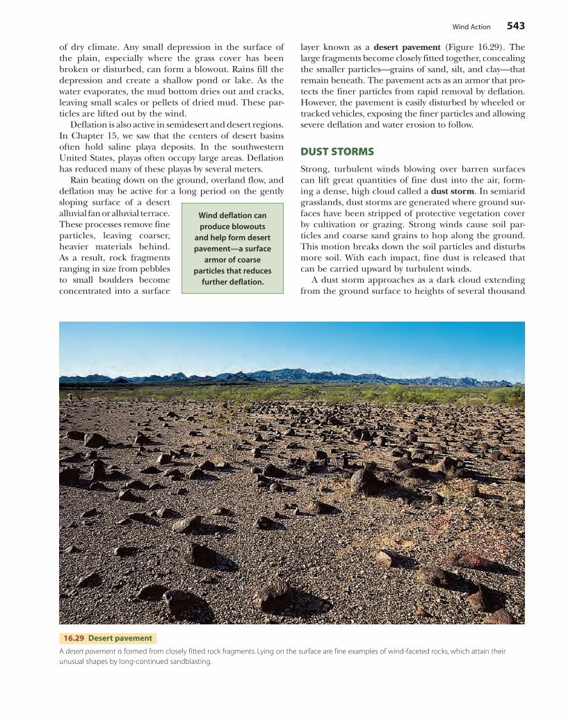
16.28 Blowout
A blowout forms when fine-grained soil is disturbed, breaking up the vegetation cover. Wind then picks up silt and fine particles, leaving sand and coarser particles behind.
A blowout is a shallow depression produced by deflation (Figure 16.28). The size of the depression may range from a few meters (10 to 20 ft) to a kilome-ter (0.6 mi) or more in diameter, although it is usually only a few meters deep. Blowouts form in plains regions
c16LandformsMadeByWavesAndWind.indd 542 4/29/10 10:18:04 AM
Wind Action 543
layer known as a desert pavement (Figure 16.29). The large fragments become closely fitted together, concealing the smaller particles—grains of sand, silt, and clay—that remain beneath. The pavement acts as an armor that pro-tects the finer particles from rapid removal by deflation. However, the pavement is easily disturbed by wheeled or tracked vehicles, exposing the finer particles and allowing severe deflation and water erosion to follow.
DUST STORMS
Strong, turbulent winds blowing over barren surfaces can lift great quantities of fine dust into the air, form-ing a dense, high cloud called a dust storm. In semiarid grasslands, dust storms are generated where ground sur-faces have been stripped of protective vegetation cover by cultivation or grazing. Strong winds cause soil par-ticles and coarse sand grains to hop along the ground. This motion breaks down the soil particles and disturbs more soil. With each impact, fine dust is released that can be carried upward by turbulent winds.
A dust storm approaches as a dark cloud extending from the ground surface to heights of several thousand
of dry climate. Any small depression in the surface of the plain, especially where the grass cover has been broken or disturbed, can form a blowout. Rains fill the depression and create a shallow pond or lake. As the water evaporates, the mud bottom dries out and cracks, leaving small scales or pellets of dried mud. These par-ticles are lifted out by the wind.
Deflation is also active in semidesert and desert regions. In Chapter 15, we saw that the centers of desert basins often hold saline playa deposits. In the southwestern United States, playas often occupy large areas. Deflation has reduced many of these playas by several meters.
Rain beating down on the ground, overland flow, and deflation may be active for a long period on the gently sloping surface of a desert alluvial fan or alluvial terrace. These processes remove fine particles, leaving coarser, heavier materials behind. As a result, rock fragments ranging in size from pebbles to small boulders become concentrated into a surface
Wind deflation can produce blowouts
and help form desert pavement—a surface
armor of coarse particles that reduces
further deflation.
16.29 Desert pavement
A desert pavement is formed from closely fitted rock fragments. Lying on the surface are fine examples of wind-faceted rocks, which attain theirunusual shapes by long-continued sandblasting.
c16LandformsMadeByWavesAndWind.indd 543 4/29/10 10:18:10 AM

544 Chapter 16 Landforms Made by Waves and Wind
meters (Figure 16.30). Typically, the advancing cloud wall represents a rapidly moving cold front. Standing within the dust cloud, you are shrouded in deep gloom or even total darkness. Visibility is cut to a few meters, and a fine choking dust penetrates everywhere.
Sand Dunes and LoessA sand dune is any hill of loose sand shaped by the wind. Sand dunes form where there is a source of sand—for example, a sandstone formation that weathers easily to release individual grains, or perhaps a beach supplied with abundant sand from a nearby river mouth. Active dunes constantly change shape under wind currents, but they must be free of a vegetation cover in order to form and move. They become inactive when stabilized by a vegetation cover, or when patterns of wind or sand sources change.
Dune sand is usually composed of quartz, which is extremely hard and doesn’t easily decay. Dune sand grains are beautifully rounded by abrasion. In strong winds, sand grains move downwind in long, low leaps, bouncing after impact with other grains. This type of hopping, bouncing movement is called saltation.
TYPES OF SAND DUNES
One common type of sand dune is an isolated dune of free sand called a barchan, or crescent dune. This type of dune has the outline of a crescent, and the points of the crescent are directed downwind (Figure 16.31). Barchan dunes usually rest on a flat, pebble-covered ground surface. They begin as a sand drift in the lee of some obstacle, such as a small hill, rock, or clump of brush. Once a sufficient mass of sand has gathered, it begins to move downwind, becom-ing a crescent. We usually find barchan dunes arranged in chains extending downwind from the sand source.
Transverse dunes are formed when there is so much sand that it completely covers the solid ground. These dunes are wave-like ridges separated by trough-like fur-rows. They are called transverse dunes because their crests are at right angles to the wind direction, much like waves on an ocean (Figure 16.32). The entire area is
The barchan dune is a crescent-shaped heap of sand that
moves across a flat, pebble-covered plain.
The points of the crescent are directed
downwind.
16.30 Dust storm
In a front reaching up to 1000 m (3300 ft) in altitude, a dust storm approaches an American facility in Iraq. It passed over in about 45 minutes, leaving a thick layer of dust in its wake.
c16LandformsMadeByWavesAndWind.indd 544 4/29/10 10:18:18 AM
Sand Dunes and Loess 545
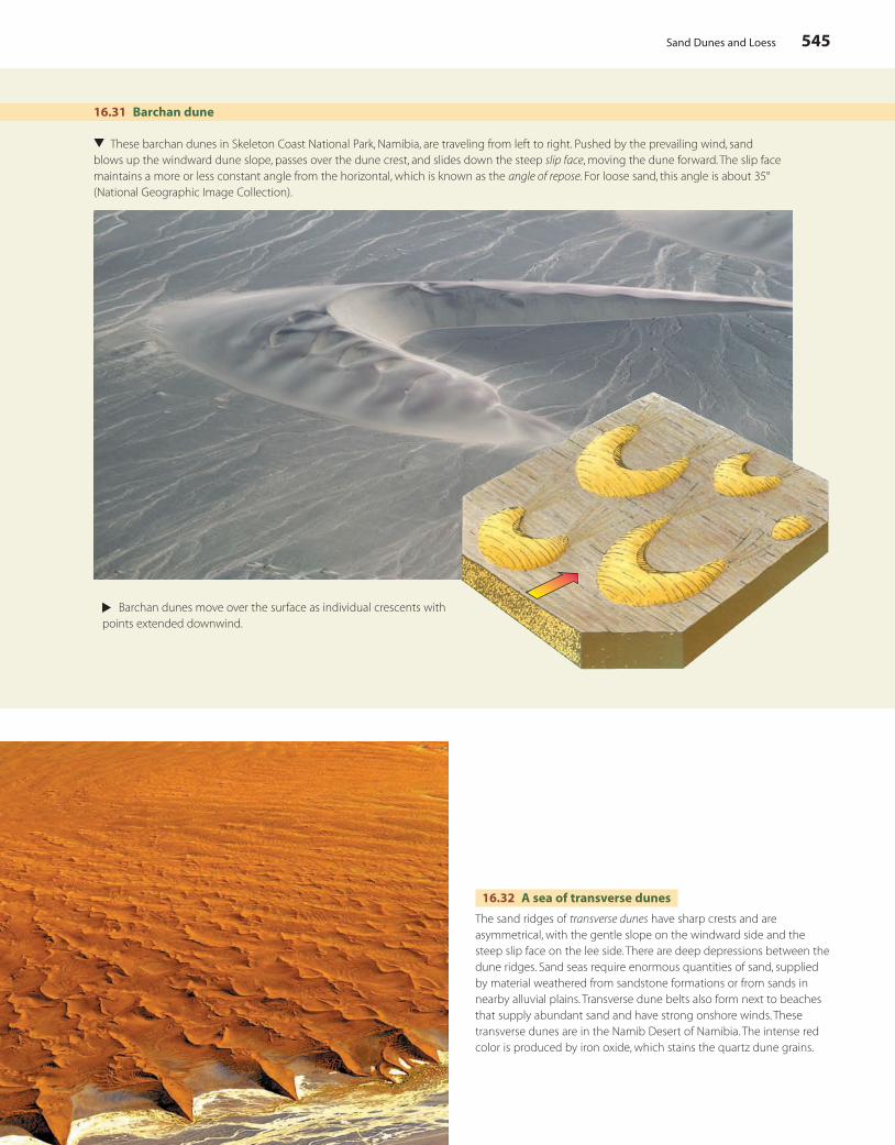
16.31 Barchan dune
▲
These barchan dunes in Skeleton Coast National Park, Namibia, are traveling from left to right. Pushed by the prevailing wind, sand blows up the windward dune slope, passes over the dune crest, and slides down the steep slip face, moving the dune forward. The slip face maintains a more or less constant angle from the horizontal, which is known as the angle of repose. For loose sand, this angle is about 35° (National Geographic Image Collection).
▲
Barchan dunes move over the surface as individual crescents with points extended downwind.
16.32 A sea of transverse dunes
The sand ridges of transverse dunes have sharp crests and are asymmetrical, with the gentle slope on the windward side and the steep slip face on the lee side. There are deep depressions between the dune ridges. Sand seas require enormous quantities of sand, supplied by material weathered from sandstone formations or from sands in nearby alluvial plains. Transverse dune belts also form next to beaches that supply abundant sand and have strong onshore winds. These transverse dunes are in the Namib Desert of Namibia. The intense red color is produced by iron oxide, which stains the quartz dune grains.
c16LandformsMadeByWavesAndWind.indd 545 4/29/10 10:18:25 AM
546 Chapter 16 Landforms Made by Waves and Wind
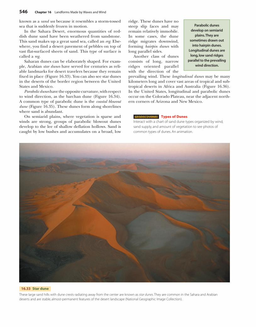
16.33 Star dune
These large sand hills with dune crests radiating away from the center are known as star dunes. They are common in the Sahara and Arabian deserts and are stable, almost-permanent features of the desert landscape (National Geographic Image Collection).
known as a sand sea because it resembles a storm-tossed sea that is suddenly frozen in motion.
In the Sahara Desert, enormous quantities of red-dish dune sand have been weathered from sandstone. This sand makes up a great sand sea, called an erg. Else-where, you find a desert pavement of pebbles on top of vast flat-surfaced sheets of sand. This type of surface is called a reg.
Saharan dunes can be elaborately shaped. For exam-ple, Arabian star dunes have served for centuries as reli-able landmarks for desert travelers because they remain fixed in place (Figure 16.33). You can also see star dunes in the deserts of the border region between the United States and Mexico.
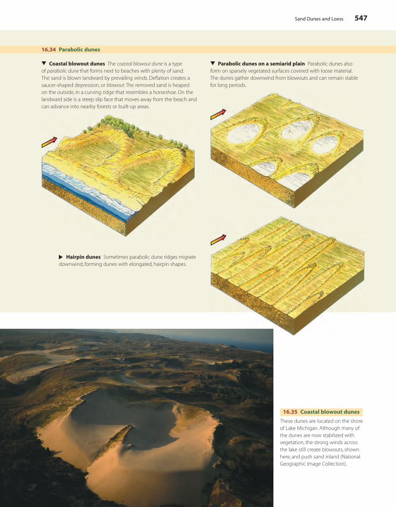
Parabolic dunes have the opposite curvature, with respect to wind direction, as the barchan dune (Figure 16.34). A common type of parabolic dune is the coastal blowout dune (Figure 16.35). These dunes form along shorelines where sand is abundant.
On semiarid plains, where vegetation is sparse and winds are strong, groups of parabolic blowout dunes develop to the lee of shallow deflation hollows. Sand is caught by low bushes and accumulates on a broad, low
ridge. These dunes have no steep slip faces and may remain relatively immobile. In some cases, the dune ridge migrates downwind, forming hairpin dunes with long parallel sides.
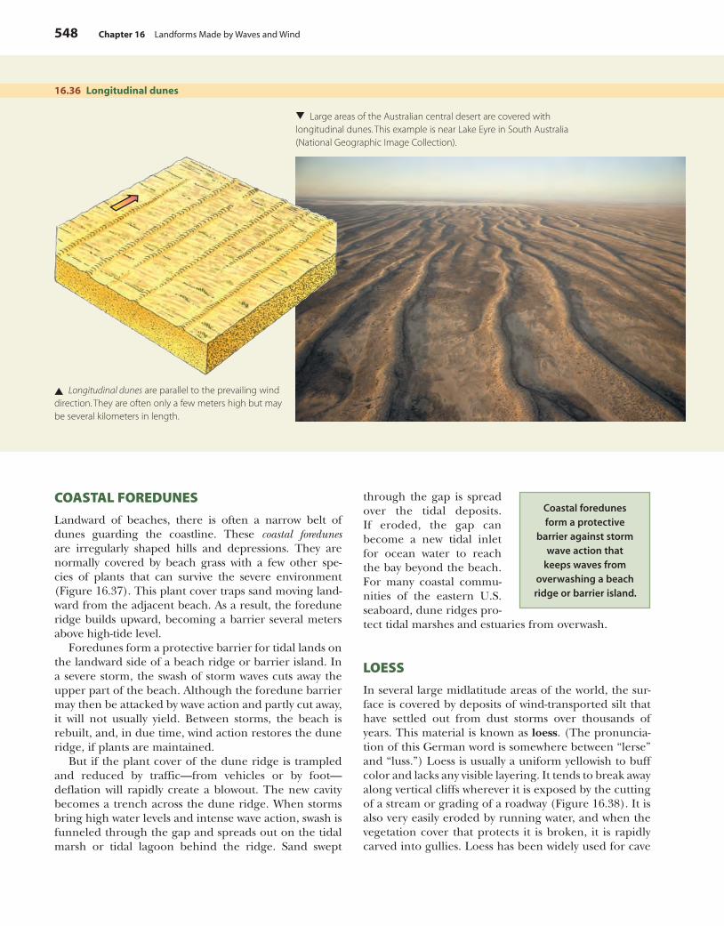
Another class of dunes consists of long, narrow ridges oriented parallel with the direction of the prevailing wind. These longitudinal dunes may be many kilometers long and cover vast areas of tropical and sub-tropical deserts in Africa and Australia (Figure 16.36). In the United States, longitudinal and parabolic dunes occur on the Colorado Plateau, near the adjacent north-ern corners of Arizona and New Mexico.
GEODISCOVERIES Types of DunesInteract with a chart of sand dune types organized by wind, sand supply, and amount of vegetation to see photos of common types of dunes. An animation.
Parabolic dunes develop on semiarid
plains. They are sometimes drawn out
into hairpin dunes. Longitudinal dunes are
long, low sand ridges parallel to the prevailing
wind direction.
c16LandformsMadeByWavesAndWind.indd 546 4/29/10 10:18:51 AM
Sand Dunes and Loess 547
16.35 Coastal blowout dunes
These dunes are located on the shore of Lake Michigan. Although many of the dunes are now stabilized with vegetation, the strong winds across the lake still create blowouts, shown here, and push sand inland (National Geographic Image Collection).
16.34 Parabolic dunes
▲
Coastal blowout dunes The coastal blowout dune is a type of parabolic dune that forms next to beaches with plenty of sand. The sand is blown landward by prevailing winds. Deflation creates a saucer-shaped depression, or blowout. The removed sand is heaped on the outside, in a curving ridge that resembles a horseshoe. On the landward side is a steep slip face that moves away from the beach and can advance into nearby forests or built-up areas.
▲
Parabolic dunes on a semiarid plain Parabolic dunes also form on sparsely vegetated surfaces covered with loose material. The dunes gather downwind from blowouts and can remain stable for long periods.
▲
Hairpin dunes Sometimes parabolic dune ridges migrate downwind, forming dunes with elongated, hairpin shapes.
c16LandformsMadeByWavesAndWind.indd 547 4/29/10 10:19:00 AM
548 Chapter 16 Landforms Made by Waves and Wind
16.36 Longitudinal dunes
▲ Longitudinal dunes are parallel to the prevailing wind direction. They are often only a few meters high but may be several kilometers in length.
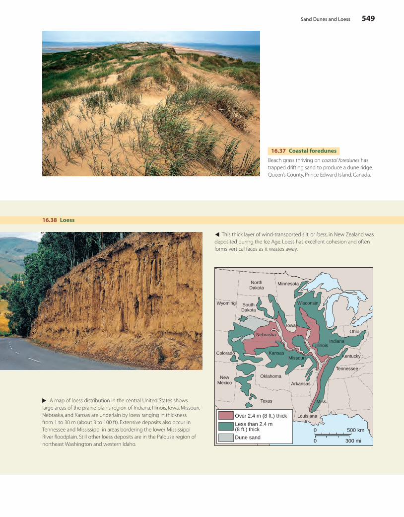
COASTAL FOREDUNES
Landward of beaches, there is often a narrow belt of dunes guarding the coastline. These coastal foredunesare irregularly shaped hills and depressions. They are normally covered by beach grass with a few other spe-cies of plants that can survive the severe environment (Figure 16.37). This plant cover traps sand moving land-ward from the adjacent beach. As a result, the foredune ridge builds upward, becoming a barrier several meters above high-tide level.
Foredunes form a protective barrier for tidal lands on the landward side of a beach ridge or barrier island. In a severe storm, the swash of storm waves cuts away the upper part of the beach. Although the foredune barrier may then be attacked by wave action and partly cut away, it will not usually yield. Between storms, the beach is rebuilt, and, in due time, wind action restores the dune ridge, if plants are maintained.
But if the plant cover of the dune ridge is trampled and reduced by traffic—from vehicles or by foot— deflation will rapidly create a blowout. The new cavity becomes a trench across the dune ridge. When storms bring high water levels and intense wave action, swash is funneled through the gap and spreads out on the tidal marsh or tidal lagoon behind the ridge. Sand swept
through the gap is spread over the tidal deposits. If eroded, the gap can become a new tidal inlet for ocean water to reach the bay beyond the beach. For many coastal commu-nities of the eastern U.S. seaboard, dune ridges pro-tect tidal marshes and estuaries from overwash.
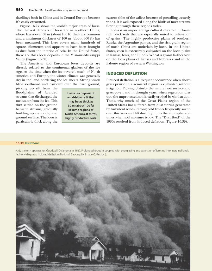
LOESS
In several large midlatitude areas of the world, the sur-face is covered by deposits of wind-transported silt that have settled out from dust storms over thousands of years. This material is known as loess. (The pronuncia-tion of this German word is somewhere between “lerse” and “luss.”) Loess is usually a uniform yellowish to buff color and lacks any visible layering. It tends to break away along vertical cliffs wherever it is exposed by the cutting of a stream or grading of a roadway (Figure 16.38). It is also very easily eroded by running water, and when the vegetation cover that protects it is broken, it is rapidly carved into gullies. Loess has been widely used for cave
Coastal foredunes form a protective
barrier against storm wave action that
keeps waves from overwashing a beach ridge or barrier island.
▲
Large areas of the Australian central desert are covered with longitudinal dunes. This example is near Lake Eyre in South Australia (National Geographic Image Collection).
c16LandformsMadeByWavesAndWind.indd 548 4/29/10 10:19:09 AM
Sand Dunes and Loess 549
16.38 Loess▲ This thick layer of wind-transported silt, or loess, in New Zealand was
deposited during the Ice Age. Loess has excellent cohesion and often forms vertical faces as it wastes away.
Over 2.4 m (8 ft.) thick
Less than 2.4 m (8 ft.) thick
Dune sand0
0
300 mi
500 km
Texas
Louisiana
Miss.
Tennessee
Kentucky
Ohio
IndianaIllinois
Arkansas
Oklahoma
Kansas
Nebraska
Missouri
Iowa
Wisconsin
Minnesota
SouthDakota
NorthDakota
Colorado
NewMexico
Wyoming
▲
A map of loess distribution in the central United States shows large areas of the prairie plains region of Indiana, Illinois, Iowa, Missouri, Nebraska, and Kansas are underlain by loess ranging in thickness from 1 to 30 m (about 3 to 100 ft). Extensive deposits also occur in Tennessee and Mississippi in areas bordering the lower Mississippi River floodplain. Still other loess deposits are in the Palouse region of northeast Washington and western Idaho.
16.37 Coastal foredunes
Beach grass thriving on coastal foredunes has trapped drifting sand to produce a dune ridge. Queen’s County, Prince Edward Island, Canada.
c16LandformsMadeByWavesAndWind.indd 549 4/29/10 10:19:14 AM
550 Chapter 16 Landforms Made by Waves and Wind
dwellings both in China and in Central Europe because it’s easily excavated.
Figure 16.27 shows the world’s major areas of loess. The thickest deposits of loess are in northern China, where layers over 30 m (about 100 ft) thick are common and a maximum thickness of 100 m (about 300 ft) has been measured. This layer covers many hundreds of square kilometers and appears to have been brought as dust from the interior of Asia. In the United States, there are thick loess deposits in the Missouri-Mississippi Valley (Figure 16.38).
The American and European loess deposits are directly related to the continental glaciers of the Ice Age. At the time when the ice covered much of North America and Europe, the winter climate was generally dry in the land bordering the ice sheets. Strong winds blew southward and eastward over the bare ground, picking up silt from the floodplains of braided streams that discharged the meltwater from the ice. This dust settled on the ground between streams, gradually building up a smooth, level ground surface. The loess is particularly thick along the
Loess is a deposit of wind-blown silt that
may be as thick as 30 m (about 100 ft) in some regions of
North America. It forms highly productive soils.
eastern sides of the valleys because of prevailing westerly winds. It is well exposed along the bluffs of most streams flowing through these regions today.
Loess is an important agricultural resource. It forms rich black soils that are especially suited to cultivation of grains. The highly productive plains of southern Russia, the Argentine pampa, and the rich grain region of north China are underlain by loess. In the United States, corn is extensively cultivated on the loess plains in Kansas, Iowa, and Illinois. Wheat is grown farther west on the loess plains of Kansas and Nebraska and in the Palouse region of eastern Washington.
INDUCED DEFLATION
Induced deflation is a frequent occurrence when short-grass prairie in a semiarid region is cultivated without irrigation. Plowing disturbs the natural soil surface and grass cover, and in drought years, when vegetation dies out, the unprotected soil is easily eroded by wind action. That’s why much of the Great Plains region of the United States has suffered from dust storms generated by turbulent winds. Strong cold fronts frequently sweep over this area and lift dust high into the atmosphere at times when soil moisture is low. The “Dust Bowl” of the 1930s resulted from induced deflation (Figure 16.39).
16.39 Dust bowl
A dust storm approaches Goodwell, Oklahoma, in 1937. Prolonged drought coupled with overgrazing and extension of farming into marginal lands led to widespread induced deflation (National Geographic Image Collection).
c16LandformsMadeByWavesAndWind.indd 550 4/29/10 10:19:23 AM
In Review 551
IN REVIEW LANDFORMS MADE BY WAVES AND WIND
Global climate change will have major impacts on ■
coastal environments. Sea level will rise, storms will increase in size and severity, and extremes of flood and drought will be exaggerated.Coastal erosion will increase. Sea-level rise and land ■
subsidence will cause the loss of many coastal wet-lands. Sensitive coral reefs will die from high water temperatures. Arctic shorelines will erode as sea ice thins and ground ice and permafrost thaw.Wind and waves are important landform-making ■
agents. Wind moves material directly by moving fine particles. Waves transfer wind energy to water motion that erodes and transports coastline materials.Waves act at the ■ shoreline—the boundary between water and land. The coastline is the zone where coastal processes operate.Waves have ■ crests and troughs, and are characterized by wave height, wave length, and wave period. Waves cause particles at or near the water surface to travel in a circular path.Wave height increases rapidly with increasing wind ■
speed, duration, and fetch.Waves expend their energy as ■ breakers that push a swash, laden with sand and gravel, onto the beach. The backwash returns water and sediment seaward.Waves erode soft sediments into ■ marine scarps. Wave-thrown rocks cut into bedrock to form marine cliffs, creating caves, arches, stacks, and abrasion platforms.Waves build ■ beaches of sand, pebbles, cobbles, or even shell fragments.Wave action produces ■ beach drift and longshore drift, which act together as littoral drift to move sediment along the shoreline. Sand bars, sandspits, and pocket beaches are formed.
Depending on sediment supply, beaches experience ■
progradation (building out) or retrogradation (cutting back). Groins help trap sand and sustain beaches.Sea level experiences a rhythmic rise and fall called ■
the ocean tide. The change of level produces tidal currents in bays and estuaries that move sediment and form salt marshes.Coastlines of ■ submergence result when coastal lands sink below sea level or sea level rises rapidly. Coast-lines of emergence form when sea level falls or subma-rine landforms are elevated and exposed.Ria coasts ■ form when fluvial landforms are submerged. Fiord coasts form when glacial valleys and troughs are submerged.Barrier-island coasts ■ have a flanking low ridge of sand at the edge of a tidal lagoon.Delta coasts ■ bring new river sediment deposits to the shoreline.Volcano coasts ■ arise where volcanic deposits reach the shoreline.Coral-reef coasts ■ occur in warm ocean waters where coral reefs build up in shallow water. Reefs may be fringing platforms, barrier reefs with lagoons, or atolls.Fault coasts ■ occur where tectonic activity brings a fault scarp to the shoreline.Marine terraces ■ form when shorelines are raised by tectonic activity.Eolian ■ landforms and processes result when sediments are transported by wind.Wind erodes by ■ abrasion and deflation. Deflation cre-ates blowouts in semidesert regions and lowers playa surfaces in deserts. In arid regions, deflation pro-duces desert pavement and dust storms.
Human activities in very dry, hot deserts have also sig-nificantly helped raise high dust clouds. As grazing ani-mals and humans trample the fine-textured soils of the desert of northwest India and Pakistan (the Thar Desert bordering the Indus River), they produce a dust cloud. Such clouds hang over the region for long periods and can extend to heights of 9 km (about 30,000 ft).
GEODISCOVERIES Web QuizTake a quick quiz on the key concepts of this chapter.
A Look AheadThis chapter has described the processes and landforms associated with wind action, either directly or as wind-driven waves. In our final chapter, we turn to the last of
the fluid agents that create landforms—glaciers. Com-pared to wind and water, glacial ice moves much more slowly but is far steadier in its motion. Like a vast con-veyor belt, glacial ice moves sediment forward relent-lessly, depositing the sediment at the ice margin, where the ice melts. By plowing its way over the landscape, glacial ice also shapes the local terrain—bulldozing loose rock from hillsides and plastering sediments underneath its vast bulk. This slow but steady action is very different from that of water, wind, and waves, and produces a set of landforms that is the subject of our last chapter.
GEODISCOVERIES Web LinksThis chapter’s web links let you visit sites of coastal erosion from San Diego to the Carolinas. Explore dunes and deserts to see wind in action.
c16LandformsMadeByWavesAndWind.indd 551 4/29/10 10:19:29 AM
552 Chapter 16 Landforms Made by Waves and Wind
KEY TERMS
shoreline, p. 526coastline, p. 526marine cliff, p. 528beach, p. 528littoral drift, p. 531
submergence, p. 534
emergence, p. 535delta, p. 537coral reef, p. 538
marine terrace p. 540deflation, p. 542blowout, p. 542desert pavement,
p. 543
dust storm, p. 543sand dune, p. 544loess, p. 548induced deflation,
p. 550
REVIEW QUESTIONS
1. How has the coastal environment changed in response to climate change, and what changes are predicted for the future? What will be the impact of these changes on coastlines and shorelines?
2. How do ocean waves arise? Where do they obtain their energy, and how do they use that energy?
3. Contrast the terms shoreline and coastline. 4. Explain how wave height is related to wind speed,
duration, and fetch of the wind. 5. Compare a marine scarp with a marine cliff. What
landforms are associated with marine cliffs? 6. What is littoral drift, and how is it produced by wave
action? Use the terms beach drift and longshore drift in your answer. Identify some landforms produced by littoral drift.
7. Identify progradation and retrogradation. How can human activity influence retrogradation?
8. Describe ocean tides and their effects on bays and estuaries. How are salt marshes formed? How can they be reclaimed for agricultural use?
9. What key features identify a coastline of submergence? Identify and compare the two types of coastlines of submergence.
10. What are the typical features of a barrier-island coast? Sketch an example of a barrier-island coast.
11. Describe the features of a delta coast and give an example.
12. Describe the shoreline of a volcano coast. 13. What conditions are necessary for the development
of coral reef coastlines? Identify three types of coral reefs, depending on their setting.
14. Describe the features of a fault coast. Where would you expect to find one?
15. How are marine terraces formed? 16. Identify and describe two types of erosional work
done by wind. 17. What process produces blowouts? What is desert pave-
ment and how does it form? 18. Describe what it might be like to experience a dust
storm. What are some sources of the dust? 19. What is a sand dune? What are the properties of the
particles that form a sand dune? 20. How do sand dunes form? Describe and compare
barchan dunes, transverse dunes, star dunes, para-bolic dunes, coastal blowout dunes, and longitudi-nal dunes.
21. How do coastal foredunes arise, and how are they maintained? How does human activity affect coastal foredunes, and what is the result?
22. Define the term loess. What is the source of loess, and how are loess deposits formed? Identify several global locations of extensive loess deposits.
Sand dunes ■ form when a source, such as a sandstone outcrop or a beach, provides abundant sand that can be moved by wind action.Barchan dunes ■ are arranged individually or in chains leading away from the sand source. They are shaped like crescents with points elongated downwind.Transverse dunes ■ form a sand sea of frozen “wave” forms arranged perpendicular to the wind direction.Star dunes ■ are large pyramids of sand that remain fixed in place.Parabolic dunes ■ are arc-shaped with points elongated upwind.Coastal blowout dunes ■ are parabolic dunes that form on shorelines with abundant sand.
Longitudinal dunes ■ parallel the wind direction and cover vast desert areas.Coastal foredunes ■ are stabilized by dune grass and help protect the shoreline from storm wave action.Loess ■ is a surface deposit of fine, wind-transported silt. It can be quite thick, and it typically forms vertical banks. Loess is very easily eroded by water and wind.In eastern Asia, the silt forming the loess was trans- ■
ported by winds from extensive interior deserts located to the north and west. In Europe and North America, the silt was derived from fresh glacial deposits during the Pleistocene Epoch.Human activities can create ■ induced deflation by break-ing protective surface covers of vegetation and desert pavement, yielding dust storms and dust bowls.
c16LandformsMadeByWavesAndWind.indd 552 4/29/10 10:19:29 AM
Essay Questions 553
ESSAY QUESTIONS
1. Consult an atlas or GoogleEarth to identify a good example of each of the following types of coastlines: ria coast, fiord coast, barrier-island coast, delta coast, coral-reef coast, and fault coast. For each example, pro-vide a brief description of the key features and other knowledge you used to identify the coastline type.
2. Wind action moves sand close to the ground in a bouncing motion, whereas silt and clay are lifted and carried longer distances. Compare landforms and deposits that result from wind transportation of sand with those that result from wind transportation of silt and finer particles.
VISUALIZING EXERCISES
1. Sketch a profile of the surface of an ocean wave, and use it to define the following terms: wave height, wave length, and wave period. Add circles with directional arrows to show the motion of water particles at key points on the wave.
2. Take a piece of paper and let it represent a map with winds coming from the north, at the top of the page. Then sketch the shapes of the following types of dunes: barchan, transverse, parabolic, hairpin, and longitudinal.
c16LandformsMadeByWavesAndWind.indd 553 4/29/10 10:19:29 AM


![Landforms Mady By Wind [Desert Landforms]](https://img.pdfslide.us/doc/110x75/56813971550346895da1066c/landforms-mady-by-wind-desert-landforms.jpg)