Embed Size (px)
Citation preview
1
Chapter 11, Part 1
General Circulation of the Atmosphere
General Circulation
• Average air flow – actual winds at a given place and time may vary considerably.
• Explains why prevailing surface winds are northeasterly in Honolulu and westerly in New York City.
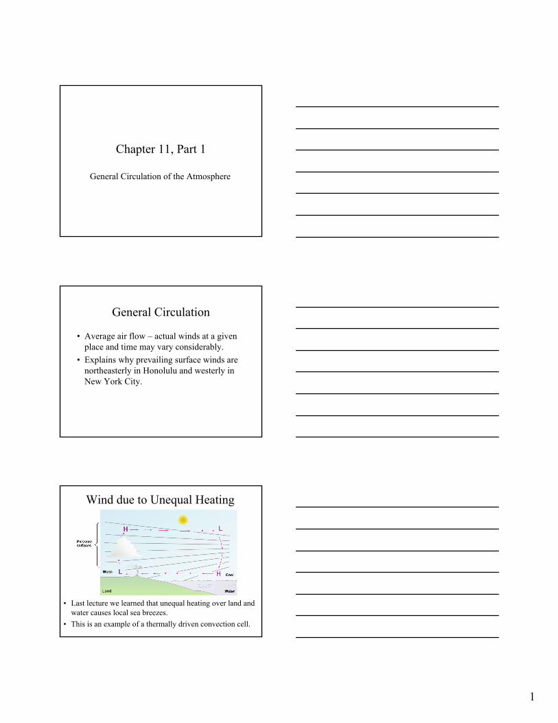
Wind due to Unequal Heating
• Last lecture we learned that unequal heating over land and water causes local sea breezes.
• This is an example of a thermally driven convection cell.
2
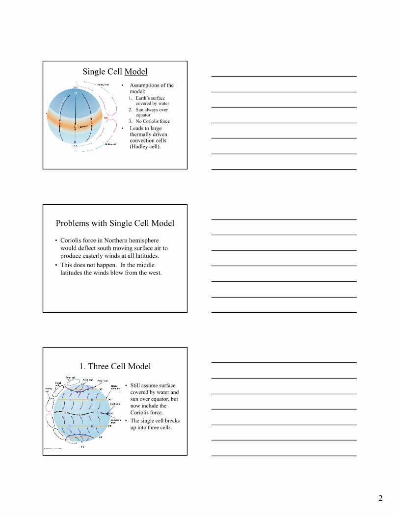
Single Cell Model• Assumptions of the
model:1. Earth’s surface
covered by water2. Sun always over
equator3. No Coriolis force
• Leads to large thermally driven convection cells (Hadley cell).
Problems with Single Cell Model
• Coriolis force in Northern hemisphere would deflect south moving surface air to produce easterly winds at all latitudes.
• This does not happen. In the middle latitudes the winds blow from the west.
1. Three Cell Model
• Still assume surface covered by water and sun over equator, but now include the Coriolis force.
• The single cell breaks up into three cells.
3
2. Three Cell Model
• Doldroms – region over equator where pressure gradients are weak and winds are light.
• The warm air near the equator rises and moves towards the poles.
• As it moves north it cools and compresses, producing subtropical highs near 30o.
• Weak pressure gradients at center of high lead to light winds (horse latitudes).
3. Three Cell Model
• From the horse latitudes (~30o) some of the surface air moves towards the equator.
• In the northern hemisphere the Coriolis force causes wind from the northeast (southeast in southern hemisphere). = Trade Winds
• The trade winds converge near the equator in the intertropical convergence zone (ITCZ).
4. Three Cell Model
• Some of the air at the horse latitudes moves towards the poles and is deflected towards the east – producing the westerlies.
• These are common from Texas into Canada.• This air encounters cold air moving south
from the poles.• The two air masses do not readily mix at the
boundary – polar front, producing a subpolar low at approximately 60o.
4
5. Three Cell Model
• At the polar front, some of the rising air returns at high levels to the horse latitudes, completing a thermally indirect cell or Ferrel cell.
• North of the polar front, cold air from the N. pole is deflected by the Coriolis force to produce the Polar easterlies.
• At the polar front some of this air rises and flows back N. creating a the weak polar cell.
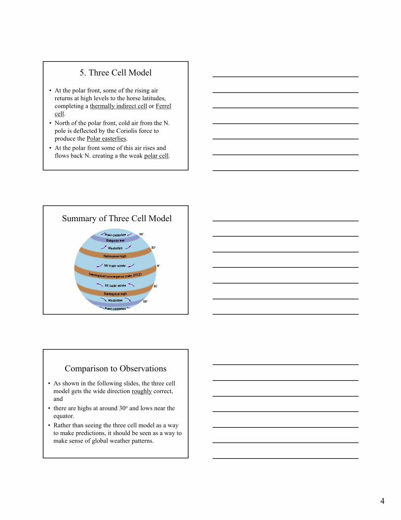
Summary of Three Cell Model
Comparison to Observations• As shown in the following slides, the three cell
model gets the wide direction roughly correct, and
• there are highs at around 30o and lows near the equator.
• Rather than seeing the three cell model as a way to make predictions, it should be seen as a way to make sense of global weather patterns.
5
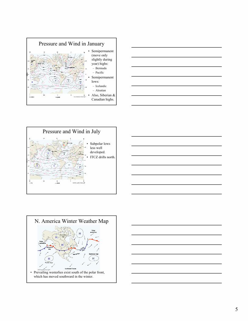
Pressure and Wind in January• Semipermanent
(move only slightly during year) highs:– Bermuda– Pacific
• Semipermanent lows:– Icelandic– Aleutian
• Also, Siberian & Canadian highs.
Pressure and Wind in July
• Subpolar lows less well developed.
• ITCZ drifts north.
N. America Winter Weather Map
• Prevailing westerlies exist south of the polar front, which has moved southward in the winter.
6
General Circulation & Precipitation• Expect abundant
rainfall where the air rises and little where it sinks.
• More rainfall in tropics where humid air rises (ITCZ) and between 40o to 55o
latitude (polar front forces air upwards).
Summer Rainfall in the U.S.
• During the summer, the Pacific high moves northward causing dry weather on the West coast.
• The Bermuda high also moves northward, but continues to bring humid air.
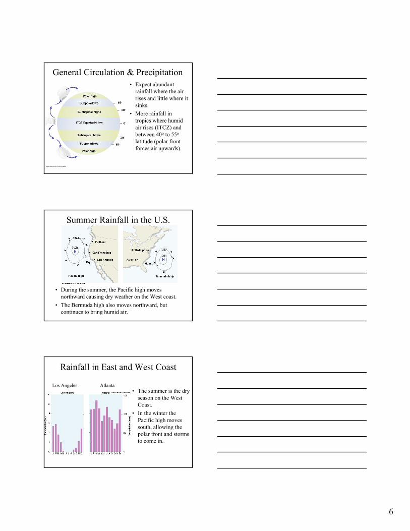
Rainfall in East and West Coast
• The summer is the dry season on the West Coast.
• In the winter the Pacific high moves south, allowing the polar front and storms to come in.
Los Angeles Atlanta
7
Jet Streams
• Jet streams are fast flowing air currents, which are 1000’s of km long, few 100 km wide, one a few kilometers thick.
• Wind speeds at the core often exceed 100 knots, and occasioanlly exceed 200 knots.
• They are usually found in the tropopause between 10 and 15 km in elevation.
Why do jet streams form?• Recall that away from the ground, wind flows
parallel to pressure contours.• The more closely spaced the isobars, the faster
the wind.• At the polar front there is a sharp change in
temperature, creating a sharp change in pressure.
• A similar rapid change in temperature can occur near the subtropical high.
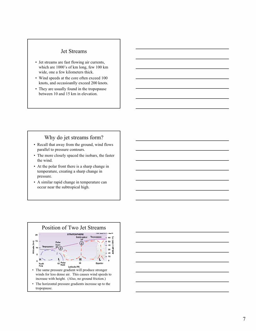
Position of Two Jet Streams
• The same pressure gradient will produce stronger winds for less dense air. This causes wind speeds to increase with height. (Also, no ground friction.)
• The horizontal pressure gradients increase up to the tropopause.
8
Formation of Polar Front Jet
• The polar front jet forms due to the rapid pressure change across the front, which produces a large pressure gradient force.
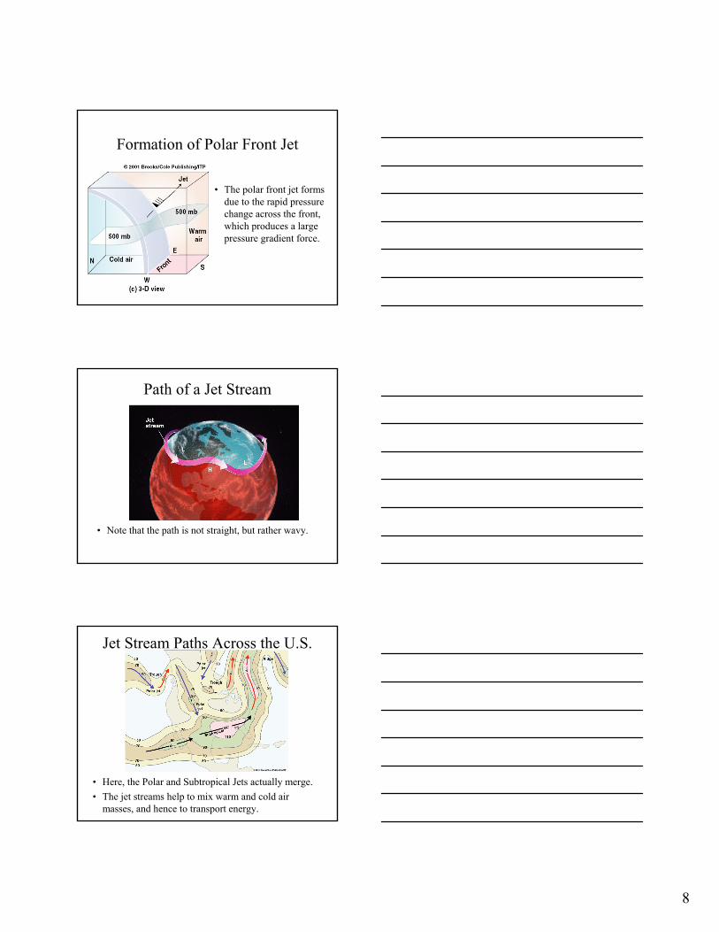
Path of a Jet Stream
• Note that the path is not straight, but rather wavy.
Jet Stream Paths Across the U.S.
• Here, the Polar and Subtropical Jets actually merge.• The jet streams help to mix warm and cold air
masses, and hence to transport energy.
9
Summary• Global circulation patterns are caused be
unequal heating of the earth’s surface.• The three-cell model explains the rough wind
directions, as well as the location of some persistent highs and lows.
• Jet streams occur where there are rapid changes in temperature and hence pressure such as at the polar front and the subtropical high.


![[Jfokus] Riding the Jet Streams](https://img.pdfslide.us/doc/110x75/58ed3dd71a28ab8f478b45fb/jfokus-riding-the-jet-streams.jpg)