Embed Size (px)
Citation preview
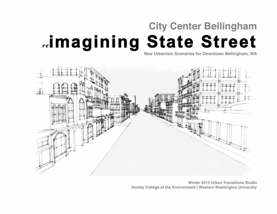
City Center Bellingham
reimagining State Street New Urbanism Scenarios for Downtown Bellingham, WA
Winter 2013 Urban Transitions Studio Huxley College of the Environment | Western Washington University
Chapter 1.0 Introduction to the State Street Corridor Urban Design Study March 14, 2013 2013 Urban Transitions Studio (UTS) The 2013 Urban Transitions Studio is a collaborative partnership between WWUʼs Urban Planning and Sustainable Development Program, Bellinghamʼs Departments of Planning and Community Development and Public Works, Sustainable Connections, Whatcom Transportation Authority, the Downtown Bellingham Partnership, and Futurewise Whatcom. Beginning in 2010, WWUʼs Planning Studio participated in a coordinated service learning curriculum that partnered several WWU classes with community and institutional partners in order to develop new urbanism planning concepts to help transition Bellingham into a more urban and sustainable community. Planning Studio is the first in a series of coordinated class investigations that emphasizes the preparation of plan/design concepts. Other classes participating in the Urban Transitions Studio program include: Planning Studio II (investigating approaches to plan implementation), Sustainable Design Studio (exploring the application of green building methods), and Environmental Impact Assessment (assessing impacts posed by the proposed development concepts). Each of the participating classes build upon the planning concepts developed in the Planning Studio class. The program is intended to expand student learning by concentrating studies over the course of an entire year and by incorporating multiple dimensions of the planning process that aims to effect positive community change towards sustainable development.
OVERVIEW This studio class applies planning principles, methods and processes of analyses from previous classroom training to develop alternative solutions for sustainable community development. The course examines ways to achieve planning’s social, environmental, and economic values through the master site
plan process to foster sustainable downtown communities. The objective of the exercise is to balance a community’s social, environmental, and economic development objectives informed through local, state, and national and international sustainable development principles. Because the problems that are presented in the studio concern a variety of complex issues, underlying each problem are questions concerning the appropriate "community fit," and the identification of opportunities and constraints that must be addressed before a planning solution can successfully emerge. This course engages students in methods for considering policy conflicts, the analysis of physical, social and economic information, and the formulation and evaluation of planning alternatives to meet the Bellingham community’s long term development objectives.
Students work both independently and within project teams and interact with a "client partner" (represented by our UTS partners). Research of public policy and interviews with informants help inform students about local problems and priorities. Students presented their conceptual recommendations in a mid-quarter critique presentation, and at a formal presentation in a public meeting before the UTS partners and the general public.
THE PROJECT State Street Priority Development Area Planning Studio evaluated development alternatives along the “State Street Corridor,” lying on the eastern edge of Bellingham’s city center. In this studio project, students drew from their acquired knowledge of the site and from urban design principles of New Urbanism to develop a Corridor District Plan proposal for the State Street site. What makes Bellinghamʼs downtown a unique and vibrant place, despite a series of recent economic setbacks over the past several decades, is due to several factors: itʼs persistent resilience; its ability to change; its traditional social and economic city-center function; its historic physical and urban infrastructure assets; its youthful demographics; and its functional diversity. Coupled with a concerted effort by the City of Bellingham and downtown business interests to foster continued social and economic revival, the downtown has experienced a process of redevelopment in recent decades. Downtown Bellingham is a great place because, in part, it wasnʼt master planned, but rather, has experienced a series of development processes over decades that has produced a rich mixture of vibrancy and diverse character. The downtown can be described as a “cluster of distinct places” which have emerged through the attraction of new investments to rehabilitate formerly underutilized spaces. This studio project examined the long underutilized, yet emerging, spaces along State Street. Student teams formulated the urban design concepts presented here to help facilitate a community dialogue regarding appropriate urban redevelopment that
meets Bellingham’s long term goals for urban infill and vibrant central city development that includes the addition of downtown housing and commercial space, public facilities, and green infrastructure development. Students evaluated current conditions and the city centerʼs long range goals to develop a conceptual plan that considers:
• Redevelopment capacity and the potential for infill • Adaptive reuse potential for underutilized sites • Architectural, historic, and urban character assets • Reuse of the State Street right of way and adjacent alleys • Public-private parking needs • Opportunities for creating public plazas and other public spaces • Improvements to pedestrian and bike connections
Hard-Soft Site Capacity Analysis The study combines objective site analysis with the studentsʼ own informed impressions of urban patterns and redevelopment potential. The study includes a capacity for redevelopment analysis – referred to as a “hard” and “soft” analysis for each recorded property. The analysis identifies properties and buildings that the students characterized as “hard” or “permanent”, upon which to build future urban development concepts. These “hard” sites contrast with “soft” sites which represent opportunities for redevelopment. For example, a vacant property, or one used solely for surface parking, may be indicated as “soft”, and therefore suitable for conversion to more intensive urban uses depending upon market demand and timing. Hard properties are existing high value assets that include sites such as the YMCA, an historic building that is intensively utilized. Newly constructed buildings are likewise categorized as “hard”. Beginning Community Goals: Phase II My Downtown Report An update to the Civic Center Master Plan has recently commenced and community place-making discussions addressing redevelopment opportunities in the State Street corridor took place in September 2013. Participants in the city sponsored planning event explored opportunities for the State Street Corridor, and, in particular, discussed how the street and sidewalk could be better utilized to serve people in the downtown district along with other revitalization measures. Several recommendations emerged from the place-making session, including: • Adjust the driving lane widths to provide pedestrian improvements such as
wider sidewalks, better crossings, mid-block crossings, as well as bicycle improvements;
• The addition of more landscaping; • Improved connections to adjacent businesses and encourage more
opportunities for businesses to spill into the street.
• Improved traffic calming; • Enhance partnerships for art, including more sculptures, murals, and wall
art; • Implement a pedestrian way finding and destination program; • Encourage spaces that promote dance parties and partnership with
adjacent businesses to capture bar crowds; • Encourage food vendors, walk-up food service windows; • Sidewalk seating should be provided; • Expand outdoor dining areas, as well as add public space to provide public
outdoor places. • Partner with YMCA to expand childhood activities to the outdoors; • Work with Saturna Capital to enhance the use of their public plaza
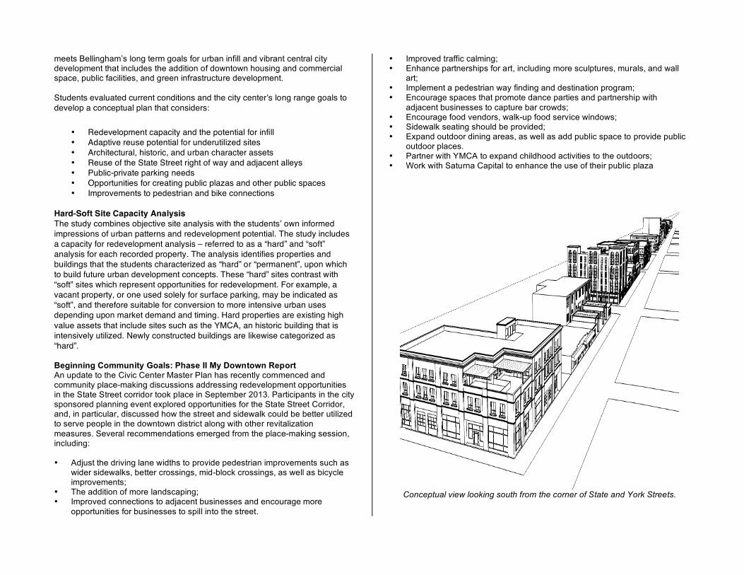
Conceptual view looking south from the corner of State and York Streets.
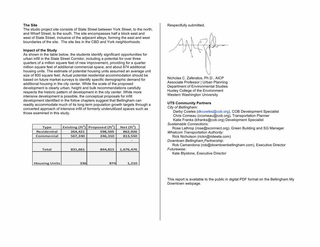
The Site The studio project site consists of State Street between York Street, to the north, and Wharf Street, to the south. The site encompasses half a block east and west of State Street, inclusive of the adjacent alleys, forming the east and west boundaries of the site. The site lies in the CBD and York neighborhoods. Impact of the Study As shown in the table below, the students identify significant opportunities for urban infill in the State Street Corridor, including a potential for over three quarters of a million square feet of new improvement, providing for a quarter million square feet of additional commercial space, and about 874 additional housing units. The estimate of potential housing units assumed an average unit size of 800 square feet. Actual potential residential accommodation should be based on future market surveys to identify specific demographic demand for additional housing in the city center. While the scale of the proposed development is clearly urban, height and bulk recommendations carefully respects the historic pattern of development in the city center. While more intensive development is possible, the conceptual proposals for infill development identified in the follow chapters suggest that Bellingham can readily accommodate much of its long term population growth targets through a concerted approach of intensive infill of formerly underutilized spaces such as those examined in this study.
Respectfully submitted,
Nicholas C. Zaferatos, Ph.D., AICP Associate Professor | Urban Planning Department of Environmental Studies Huxley College of the Environment Western Washington University UTS Community Partners City of Bellingham:
Darby Cowles ([email protected]), COB Development Specialist Chris Comeau ([email protected]), Transportation Planner Katie Franks ([email protected]) Development Specialist
Sustainable Connections: Rose Lathrop ([email protected]). Green Building and SG Manager Whatcom Transportation Authority: Rick Nicholson ([email protected]) Downtown Bellingham Partnership: Rob Camandona ([email protected]), Executive Director Futurewise: Kate Blystone, Executive Director
This report is available to the public in digital PDF format on the Bellingham My Downtown webpage.
!"#$ %&'()'*+,-.)/0 123#3($4,-.)/0 5$),-.)/06$('4$*)'78 /9:;:/<,,,,,,,, =>?;=@=,,,,,,,,,,,, ?9/;>/9,,,,,A3BB$2C'78 =9D;/:@,,,,,,,, /:9;E<@,,,,,,,,,,,, ?<E;==@,,,,,
F,,,,,,,,,,,,,,
!3)78 ?E<;99<,,,,,,,, ?::;?<=,,,,,,,,,,,, <;9D9;:D9,,
G3H('*+,I*')( EE9 ?D: <;/<@,,,,,,,,,,
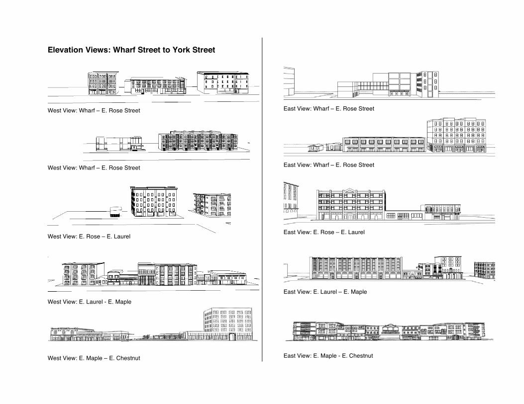
Elevation Views: Wharf Street to York Street
West View: Wharf – E. Rose Street
West View: Wharf – E. Rose Street
West View: E. Rose – E. Laurel
West View: E. Laurel - E. Maple
West View: E. Maple – E. Chestnut
East View: Wharf – E. Rose Street
East View: Wharf – E. Rose Street
East View: E. Rose – E. Laurel
East View: E. Laurel – E. Maple
East View: E. Maple - E. Chestnut
West View: E. Chestnut – E. Holly
West View: E. Holly – E. Magnolia
West View: E. Magnolia – E. Champion -
West View: E. Champion – York Street
East View: E. Chestnut – E. Holly
East View: E. Holly – E. Magnolia
East View: E. Magnolia – E. Champion
East View: E. Champion – York Street
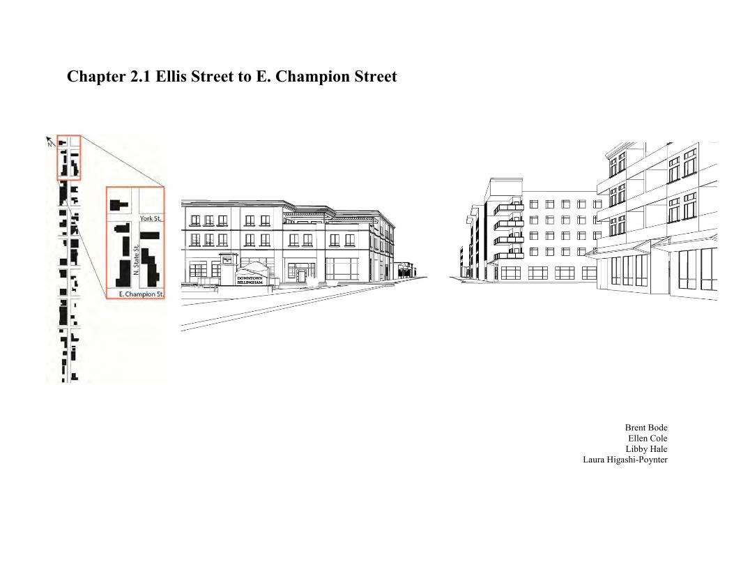
Chapter 2.1 Ellis Street to E. Champion Street
Brent Bode Ellen Cole
Libby Hale Laura Higashi-Poynter
Chapter 2.0 Land Use Plan Chapter 2.1 Ellis St. to E. Champion St. 2.1.1 Vision, Goal and Objective Statements
Create a welcoming entry into downtown on the northern end.
Provide the feeling of safety throughout State St. Create the desire to walk State St. at all times of the day. Amplify the existing natural features to create a beautiful
and usable space. Maximize infill and embrace residency.
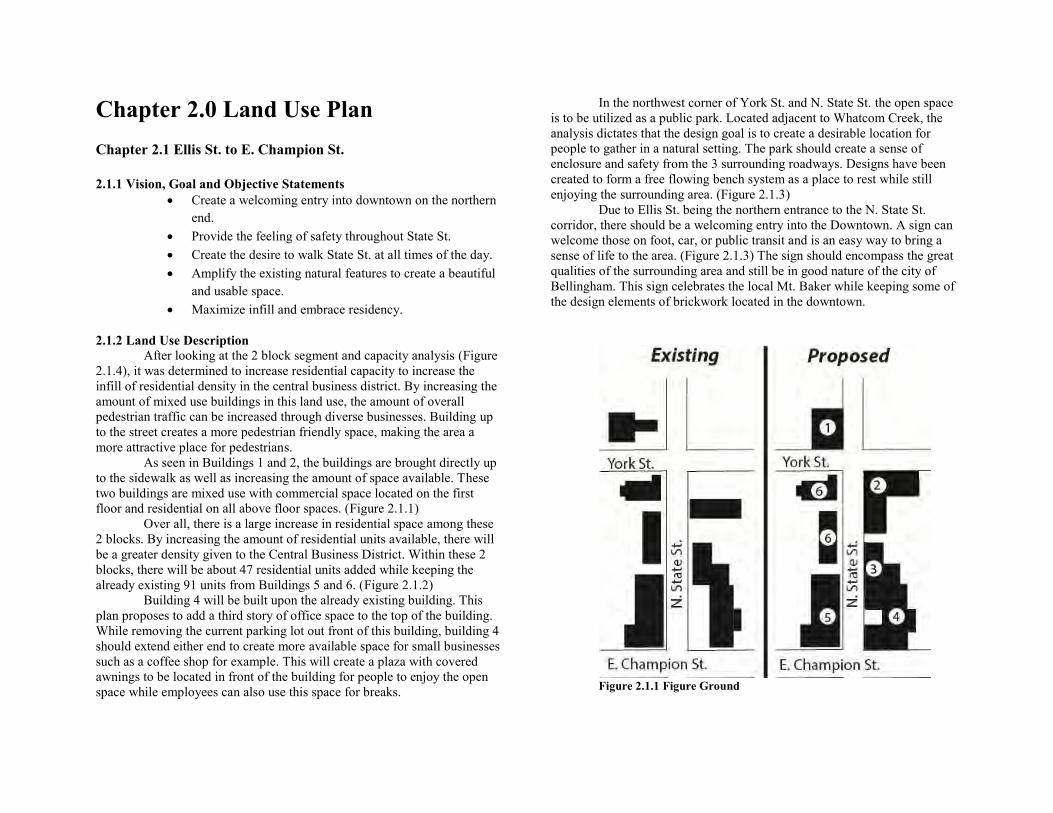
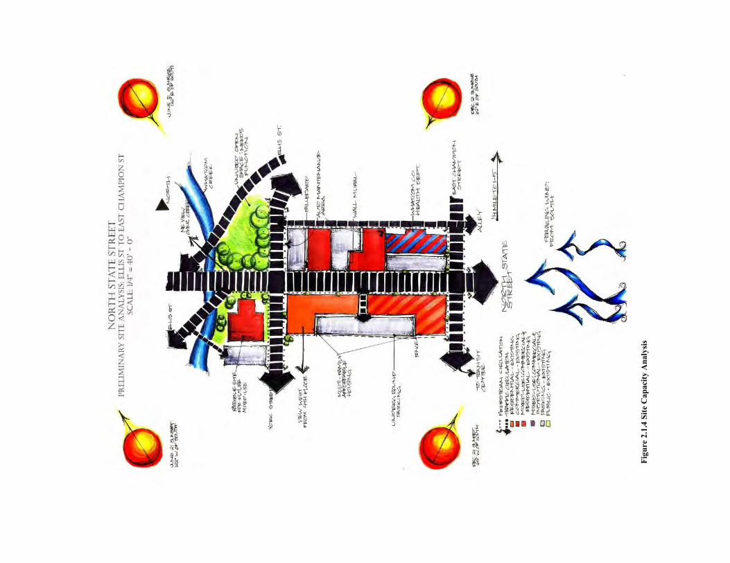
2.1.2 Land Use Description After looking at the 2 block segment and capacity analysis (Figure
2.1.4), it was determined to increase residential capacity to increase the infill of residential density in the central business district. By increasing the amount of mixed use buildings in this land use, the amount of overall pedestrian traffic can be increased through diverse businesses. Building up to the street creates a more pedestrian friendly space, making the area a more attractive place for pedestrians. As seen in Buildings 1 and 2, the buildings are brought directly up to the sidewalk as well as increasing the amount of space available. These two buildings are mixed use with commercial space located on the first floor and residential on all above floor spaces. (Figure 2.1.1) Over all, there is a large increase in residential space among these 2 blocks. By increasing the amount of residential units available, there will be a greater density given to the Central Business District. Within these 2 blocks, there will be about 47 residential units added while keeping the already existing 91 units from Buildings 5 and 6. (Figure 2.1.2) Building 4 will be built upon the already existing building. This plan proposes to add a third story of office space to the top of the building. While removing the current parking lot out front of this building, building 4 should extend either end to create more available space for small businesses such as a coffee shop for example. This will create a plaza with covered awnings to be located in front of the building for people to enjoy the open space while employees can also use this space for breaks.
In the northwest corner of York St. and N. State St. the open space is to be utilized as a public park. Located adjacent to Whatcom Creek, the analysis dictates that the design goal is to create a desirable location for people to gather in a natural setting. The park should create a sense of enclosure and safety from the 3 surrounding roadways. Designs have been created to form a free flowing bench system as a place to rest while still enjoying the surrounding area. (Figure 2.1.3) Due to Ellis St. being the northern entrance to the N. State St. corridor, there should be a welcoming entry into the Downtown. A sign can welcome those on foot, car, or public transit and is an easy way to bring a sense of life to the area. (Figure 2.1.3) The sign should encompass the great qualities of the surrounding area and still be in good nature of the city of Bellingham. This sign celebrates the local Mt. Baker while keeping some of the design elements of brickwork located in the downtown.
Figure 2.1.1 Figure Ground
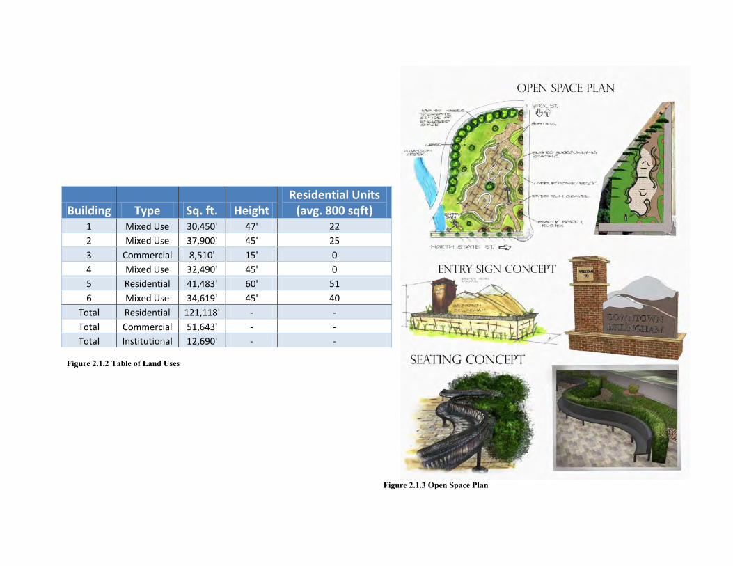
Figure 2.1.2 Table of Land Uses
Figure 2.1.3 Open Space Plan
Building Type Sq. ft. Height Residential Units
(avg. 800 sqft) 1 Mixed Use 30,450' 47' 22
2 Mixed Use 37,900' 45' 25
3 Commercial 8,510' 15' 0
4 Mixed Use 32,490' 45' 0
5 Residential 41,483' 60' 51
6 Mixed Use 34,619' 45' 40
Total Residential 121,118' - -
Total Commercial 51,643' - -
Total Institutional 12,690' - -
Figu
re 2
.1.4
Site
Cap
acity
Ana
lysi
s
2.1.4 Problems and Opportunities The Northern most blocks in the North State Street corridor extend from Ellis Street to East Champion Street. This space contains mixed use development. Bellingham’s zoning allows for many opportunities where redevelopment can support jobs, housing, entertainment, or a combination in mixed-use development. A Site Capacity Analysis was carried out to examine existing parcel information and the city’s growth goals to develop the proposed redevelopment plan. The steps taken in developing this Site Capacity Analysis include identifying:
1. Site strengths and shortcomings (Landmarks, viewsheds, characteristics and notable features)
2. Vacant land which cannot be developed due to environmental restraints
3. “Hard”, “Soft”, and “Moderate” sites within the corridor 4. Places with public services and/or spaces suitable for open spaces
and plazas
1. Site Strengths and Shortcomings: Strengths-Walton Place One and Two incorporates multifamily affordable housing and mixed-use development, between York Street and East Champion Street. Walton Place also contains and underground parking lot, which eliminates the need for expansive surface parking lots. The view West from the rooftop on Walton Place provides sweeping panoramic views of downtown and views toward Bellingham Bay. Whatcom Creek is located within this section of North State Street, and there is potential for incorporation of the creek and its natural features into the design for this area. Louis Auto Glass, Firestone, and the surrounding auto shops provide an auto maintenance character node between York Street and East Champion Street. There is also a cultural and historic wall mural located on Louis Auto Glass. The transit center is located one block West of North State Street and East Champion. The location of the transit center allows for the potential for high foot traffic volume along this section of North State Street.
Shortcomings- This portion of North State Street currently lacks pedestrian traffic, which would boost the local economy and attract businesses to this area. The open space south of Whatcom Creek, owned by Puget Sound Energy, does not currently provide for public access to the creek. Providing access to this area would attract more people to the area. Views over Whatcom Creek are currently not what they could be if the area was landscaped, given a purpose, and oriented toward the public. Parking along these blocks is generally surface parking in front of buildings, which discourages people from walking along North State Street.
2. Vacant land and lands which cannot be developed due to environmental restraints: The Northern most blocks included in this corridor contains Whatcom Creek, which flows from Lake Whatcom (east to west) to Bellingham Bay. Whatcom Creek offers salmon spawning habitat. Lands within 50 feet of Whatcom Creek cannot be built on, but landscaping within this 50 foot setback would benefit the efforts towards creek restoration and provide valuable public access and park amenity. The vacant lot, owned by Puget Sound Energy, located south of Whatcom Creek, can be developed as a Northern entry to Downtown Bellingham.
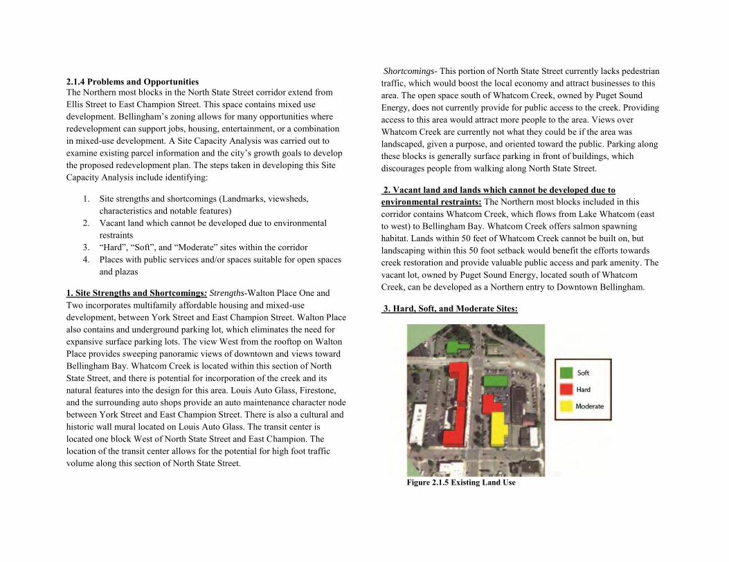
3. Hard, Soft, and Moderate Sites:
Figure 2.1.5 Existing Land Use
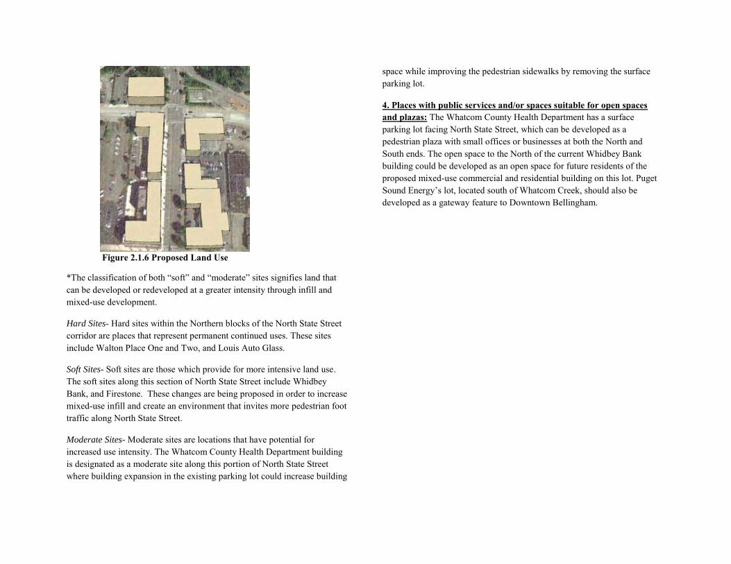
Figure 2.1.6 Proposed Land Use
*The classification of both “soft” and “moderate” sites signifies land that can be developed or redeveloped at a greater intensity through infill and mixed-use development.
Hard Sites- Hard sites within the Northern blocks of the North State Street corridor are places that represent permanent continued uses. These sites include Walton Place One and Two, and Louis Auto Glass.
Soft Sites- Soft sites are those which provide for more intensive land use. The soft sites along this section of North State Street include Whidbey Bank, and Firestone. These changes are being proposed in order to increase mixed-use infill and create an environment that invites more pedestrian foot traffic along North State Street.
Moderate Sites- Moderate sites are locations that have potential for increased use intensity. The Whatcom County Health Department building is designated as a moderate site along this portion of North State Street where building expansion in the existing parking lot could increase building
space while improving the pedestrian sidewalks by removing the surface parking lot.
4. Places with public services and/or spaces suitable for open spaces and plazas: The Whatcom County Health Department has a surface parking lot facing North State Street, which can be developed as a pedestrian plaza with small offices or businesses at both the North and South ends. The open space to the North of the current Whidbey Bank building could be developed as an open space for future residents of the proposed mixed-use commercial and residential building on this lot. Puget Sound Energy’s lot, located south of Whatcom Creek, should also be developed as a gateway feature to Downtown Bellingham.
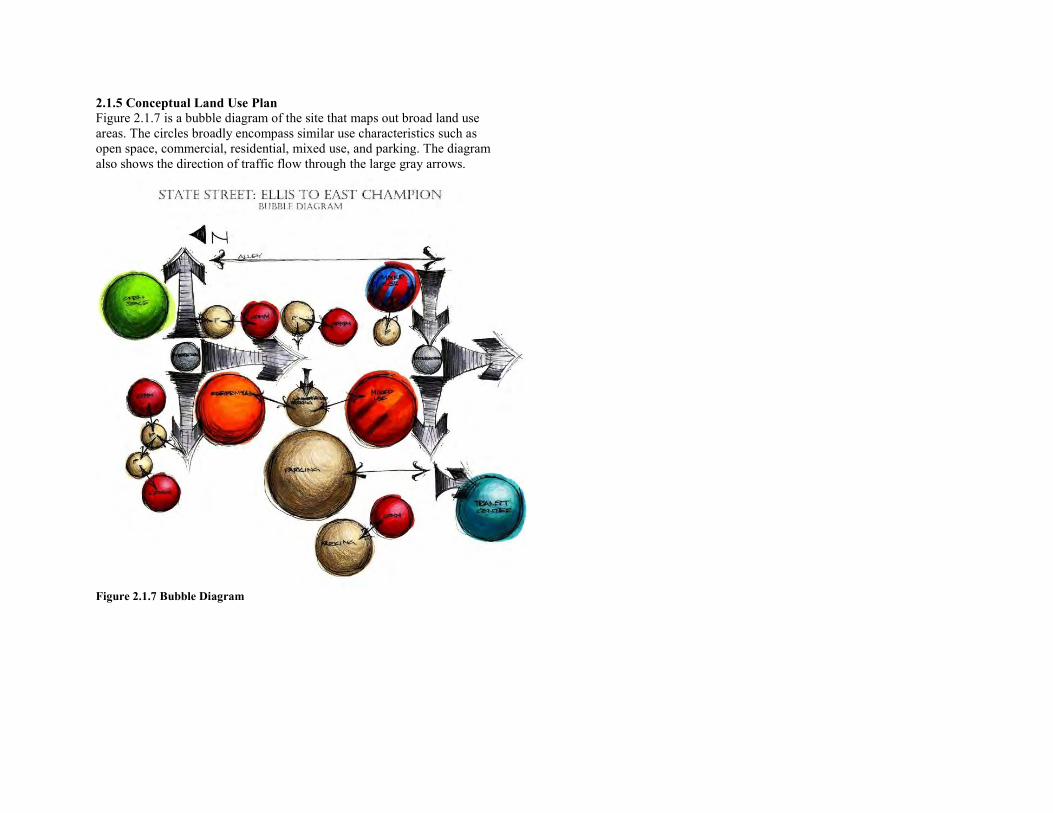
2.1.5 Conceptual Land Use Plan Figure 2.1.7 is a bubble diagram of the site that maps out broad land use areas. The circles broadly encompass similar use characteristics such as open space, commercial, residential, mixed use, and parking. The diagram also shows the direction of traffic flow through the large gray arrows.
Figure 2.1.7 Bubble Diagram

2.1.6 Proposed Land Use Plan Concepts
Figure 2.1.8 East Elevation
Figure 2.1.9 West Elevation
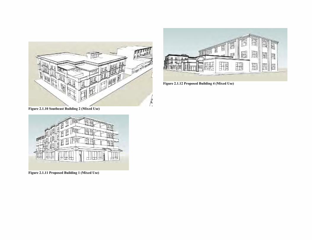
Figure 2.1.10 Southeast Building 2 (Mixed Use)
Figure 2.1.11 Proposed Building 1 (Mixed Use)
Figure 2.1.12 Proposed Building 4 (Mixed Use)
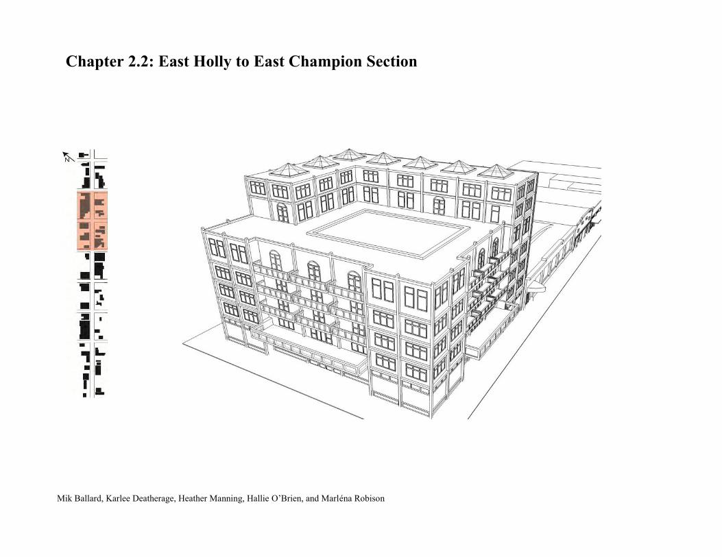
Chapter 2.2: East Holly to East Champion Section
Mik Ballard, Karlee Deatherage, Heather Manning, Hallie O’Brien, and Marléna Robison
2.2.1 Vision, Goal and Objectives Statements
This section of the report focuses on the portion of State Street between East Champion Street and East Holly Street. The intent of this section is to identify the existing assets and opportunities for improvement within this portion of State Street.
Vision
The two-block segment of State Street located between East Champion and East Holly is rich with architectural heritage of Bellingham’s past, mixed with relatively modern buildings and home to many local and innovative businesses. The vision for development within this area complements the existing uses and encourages economic growth, community interaction, and a vibrant pedestrian environment.
Goals and Objectives
Specific goals established for the two block segment of State Street between East Champion Street and East Holly Street include: shifting the focus towards the pedestrian rather than the automobile and promoting the distinct “beer and bowling,” casual atmosphere and eclectic feel of the area.
To accomplish the first goal of orienting development towards the pedestrian, several objectives were defined.
Street furnishings Encouraging businesses to spill out onto the sidewalk Building fronts coming right up to the sidewalk Community art
To maintain the distinct “beer and bowling” atmosphere and eclectic feel of State Street, the plan will:
Development of mixed-use infill buildings that are compatible with existing structures
Encourage community art Increase food vendors during late hours
2.2.2 Land Use
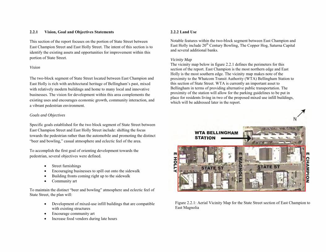
Notable features within the two-block segment between East Champion and East Holly include 20th Century Bowling, The Copper Hog, Saturna Capital and several additional banks. Vicinity Map
The vicinity map below in figure 2.2.1 defines the perimeters for this section of the report. East Champion is the most northern edge and East Holly is the most southern edge. The vicinity map makes note of the proximity to the Whatcom Transit Authority (WTA) Bellingham Station to this section of State Street. WTA is currently an important asset to Bellingham in terms of providing alternative public transportation. The proximity of the station will allow for the parking guidelines to be put in place for residents living in two of the proposed mixed use infill buildings, which will be addressed later in the report.
Figure 2.2.1: Aerial Vicinity Map for the State Street section of East Champion to East Magnolia

2.2.3 Site Capacity Analysis
Figure 2.2.2 depicts which sites have been deemed “soft” and “hard”– sites that have been designated as fit for redevelopment or infill and which sites will be preserved. The sites that have been determined hard are establishments with inherit value that will withstand the tests of and represent substantial investment. They meet the standards for the vision of State Street by coming directly to the sidewalk, by promoting economic growth, and by maintaining the historic charm apparent through much of the downtown Bellingham.
Establishments that have been designated soft fail to meet the standards for the vision of State Street or are generally considered underutilized sites, serving as an opportunity for infill development.
2.2.4 Issues and Opportunities
Upon completion of the site capacity analysis, a number of issues and opportunities became apparent.
Issues
Saturna Capital’s plaza is underutilized and an uninviting space No benches or outdoor seating exist within the two block segment
of State Street Lack of pedestrian activity centers Vacancy in the building previously occupied by Harley Davidson Minimal outdoor public art Underutilized corners at Champion and State, Magnolia and State,
and Holly and State Surface parking lots fronting the street Alleys are difficult to access from this segment of State Street;
underutilized Limited dining opportunities, especially the block from East
Magnolia to East Champion Inconsistent architectural styles throughout the two block segment Current building uses focus on the automobile, which have brought
great economic success over the past few years. The plan recognizes the shift from automobile to human scale.
Opportunities
Collaborating with Saturna Capital to open their plaza to the public
Installing inexpensive seating and street furniture to create a more inviting pedestrian atmosphere
Encourage economic development and infill that will attract more people to this segment of State Street, such as restaurants and cafes with seating spilling out onto the sidewalk, bars, art pieces, and retail
Cater to more community art projects and mural creation on blank building walks, art pieces on sidewalks, etcetera
Develop underground parking garages Incorporate pedestrian areas and mid-block connectivity, like
pocket parks, open spaces leading to alley ways
Figure 2.2.2: Hard and Soft Analysis
Recognize the inherit value of historic architecture and maintain a standard of architectural style in future development.
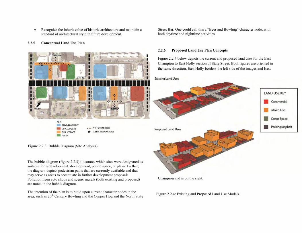
2.2.5 Conceptual Land Use Plan
The bubble diagram (figure 2.2.3) illustrates which sites were designated as suitable for redevelopment, development, public space, or plaza. Further, the diagram depicts pedestrian paths that are currently available and that may serve as areas to accentuate in further development proposals. Pollution from auto shops and scenic murals (both existing and proposed) are noted in the bubble diagram.
The intention of the plan is to build upon current character nodes in the area, such as 20th Century Bowling and the Copper Hog and the North State
Street Bar. One could call this a “Beer and Bowling” character node, with both daytime and nighttime activities.
2.2.6 Proposed Land Use Plan Concepts
Figure 2.2.4 below depicts the current and proposed land uses for the East Champion to East Holly section of State Street. Both figures are oriented in the same direction. East Holly borders the left side of the images and East
Champion and is on the right.
Table of Land Uses
Figure 2.2.3: Bubble Diagram (Site Analysis)
Figure 2.2.4: Existing and Proposed Land Use Models
Currently this segment of State Street is dominated by commercial uses. The plan proposes to incorporate more mixed use buildings which will accommodate the existing commercial business as well as providing a greater range of housing options for future growth of the city. Six out of the eight corner lots are built up intensely compared to the rest of the site due to higher values attributed to corner lot locations.
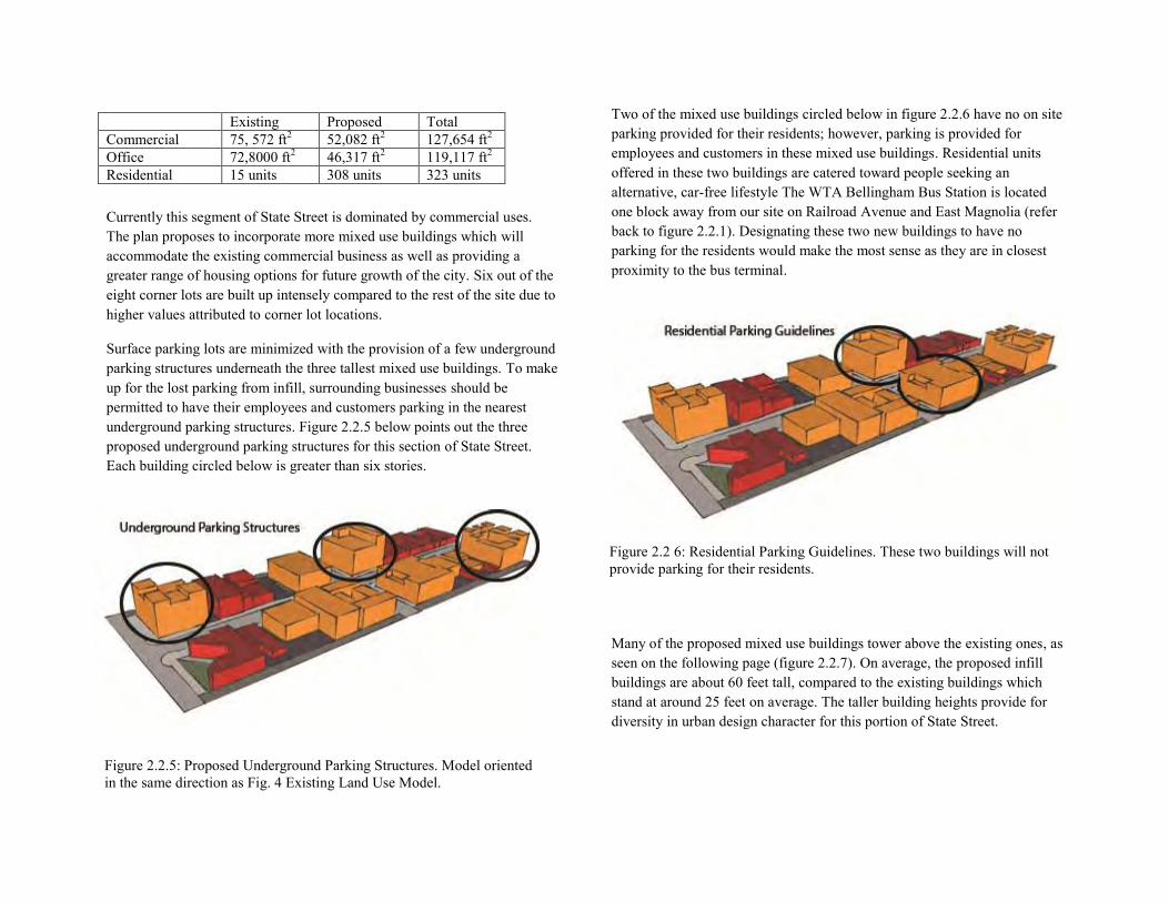
Surface parking lots are minimized with the provision of a few underground parking structures underneath the three tallest mixed use buildings. To make up for the lost parking from infill, surrounding businesses should be permitted to have their employees and customers parking in the nearest underground parking structures. Figure 2.2.5 below points out the three proposed underground parking structures for this section of State Street. Each building circled below is greater than six stories.
Two of the mixed use buildings circled below in figure 2.2.6 have no on site parking provided for their residents; however, parking is provided for employees and customers in these mixed use buildings. Residential units offered in these two buildings are catered toward people seeking an alternative, car-free lifestyle The WTA Bellingham Bus Station is located one block away from our site on Railroad Avenue and East Magnolia (refer back to figure 2.2.1). Designating these two new buildings to have no parking for the residents would make the most sense as they are in closest proximity to the bus terminal.
Many of the proposed mixed use buildings tower above the existing ones, as seen on the following page (figure 2.2.7). On average, the proposed infill buildings are about 60 feet tall, compared to the existing buildings which stand at around 25 feet on average. The taller building heights provide for diversity in urban design character for this portion of State Street.
Existing Proposed Total Commercial 75, 572 ft2 52,082 ft2 127,654 ft2 Office 72,8000 ft2 46,317 ft2 119,117 ft2 Residential 15 units 308 units 323 units
Figure 2.2.5: Proposed Underground Parking Structures. Model oriented in the same direction as Fig. 4 Existing Land Use Model.
Figure 2.2 6: Residential Parking Guidelines. These two buildings will not provide parking for their residents.
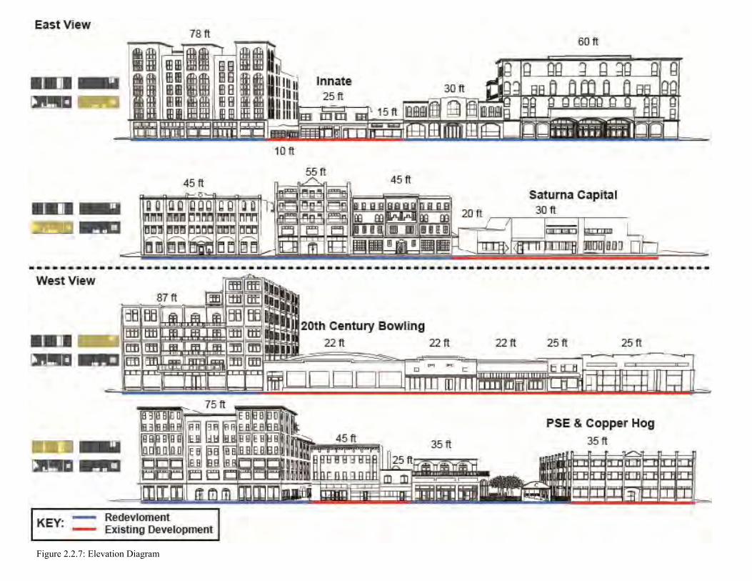
Figure 2.2.7: Elevation Diagram
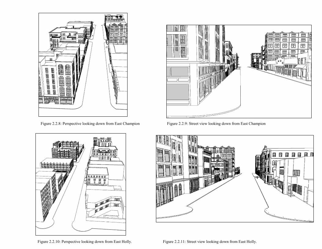
Figure 2.2.8: Perspective looking down from East Champion Figure 2.2.9: Street view looking down from East Champion
Figure 2.2.10: Perspective looking down from East Holly. Figure 2.2.11: Street view looking down from East Holly.
Chapter 2.3: E. Holly Street to E. Maple Street
Katherine McDanold Alyssa Ryan Nick Bruno
Gabe Kincaid
Table of Contents
2.3.1 Vision, Goals, and Objective Statements 2.3.2 Land Use Descriptions
Vicinity Map
Historic Buildings
Daylight Building
Herald Building
Laube Hotel
YMCA
2.3.3 Site Capacity Analysis Hard/Soft Analysis
Figure-Grounds 2.3.4 Issues and Opportunities 2.3.5 Conceptual Land Use Plan 2.3.6 Proposed Land Use Plan Concepts Street View Elevations
Plaza
Mixed Use Center
2.3.1 Vision, Goals and Objective Statements
Though State Street is characteristic of classic Bellingham—containing unique shops, restaurants and college bars, scattered between prominent historic buildings—the disjointed development along the street acts as a barrier to a true cohesive personality. Thus, through the incorporation of infill development strategies, State Street is re-envisioned as a character hub. This section could become a major downtown area with retail landmarks, unique parks, and varied city living options, suitable for residents of all incomes.
This specific two block section contains many of the existing destinations on State Street, such as the YMCA and the Up and Up Tavern, as well as prominent historic buildings, like the Herald building. Thus, within this segment, a “center” for the State Street corridor district is envisioned. This section, lying between East Holly Street and East Maple Street, is imagined as the economic core of State Street, with various types of residential, mixed-use buildings, and an aesthetically pleasing yet functional outdoor plaza. It is intended that this center will become a strong character source, attracting people and adding culture to State Street, and to downtown Bellingham as a whole.
2.3.2 Land Use Descriptions
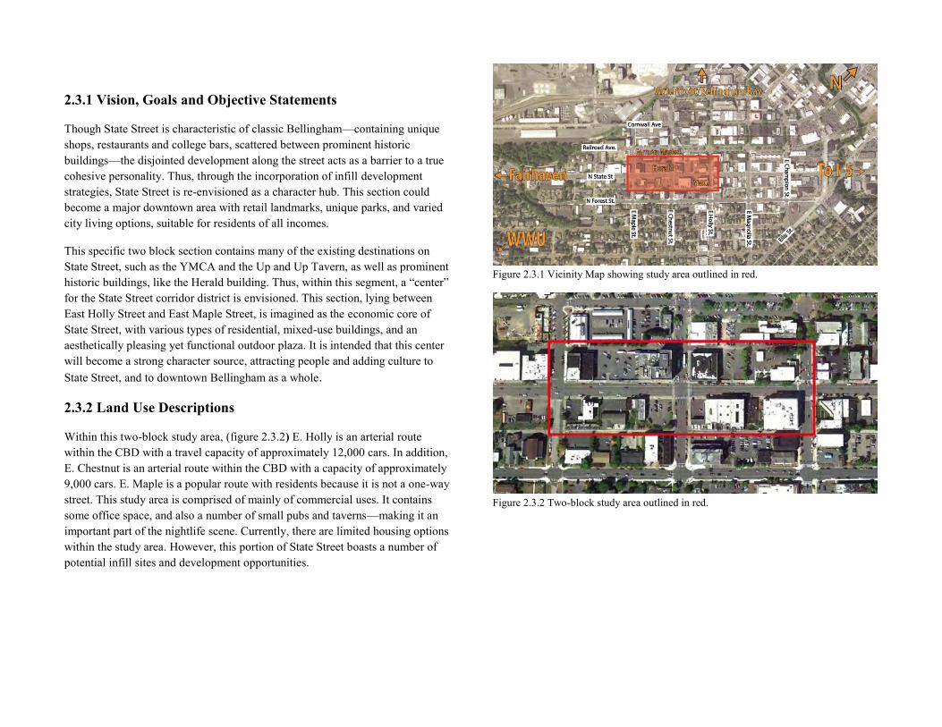
Within this two-block study area, (figure 2.3.2) E. Holly is an arterial route within the CBD with a travel capacity of approximately 12,000 cars. In addition, E. Chestnut is an arterial route within the CBD with a capacity of approximately 9,000 cars. E. Maple is a popular route with residents because it is not a one-way street. This study area is comprised of mainly of commercial uses. It contains some office space, and also a number of small pubs and taverns—making it an important part of the nightlife scene. Currently, there are limited housing options within the study area. However, this portion of State Street boasts a number of potential infill sites and development opportunities.
Figure 2.3.1 Vicinity Map showing study area outlined in red.
Figure 2.3.2 Two-block study area outlined in red.
Historic Buildings
This section describes historic structures within the two-block study area. Each of them has served as a prominent landmark, and influenced the character of the study area, many for over a hundred years. Preserving and complementing these buildings is of the utmost importance for this project. This means mimicking the architectural styling for new structures, and complementing the uses that currently exist within.
Daylight Building
Figure 2.3.3 Daylight Building1
The Daylight building was completed in 1904. Designed by a local architect, and constructed from local materials (local brick, Chuckanut Sandstone), the building has been a landmark in Bellingham for over a century. Although fires destroyed much of the interior in 1926 and 1928, the exterior has remained almost completely the same. The building has served many owners and uses. It has been home to many offices residences, taverns restaurants, grocers, a car repair shop, printers, and much more. Today, the bottom floor is comprised of commercial and retail uses, while the upper floors are apartment units.2
1 http://myweb.facstaff.wwu.edu/talbot/BhmCityCenterPixHTM/HRStateSt.html
2 http://www.cob.org/services/planning/historic/buildings/22-daylight-building.aspx
Herald Building
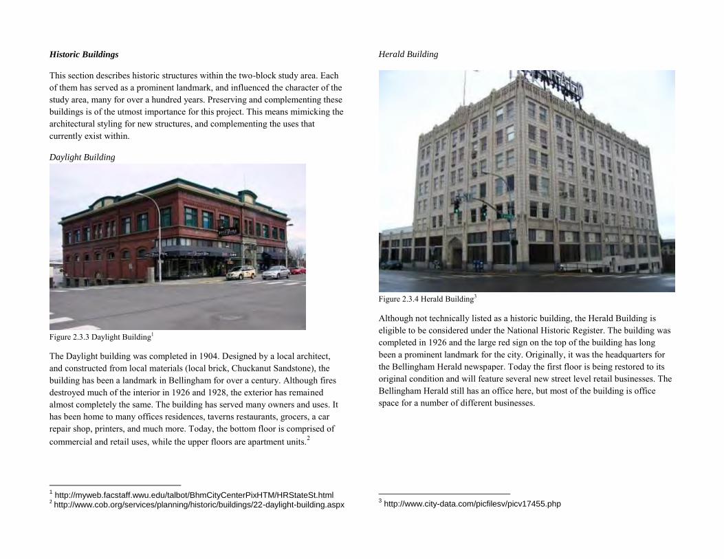
Figure 2.3.4 Herald Building3
Although not technically listed as a historic building, the Herald Building is eligible to be considered under the National Historic Register. The building was completed in 1926 and the large red sign on the top of the building has long been a prominent landmark for the city. Originally, it was the headquarters for the Bellingham Herald newspaper. Today the first floor is being restored to its original condition and will feature several new street level retail businesses. The Bellingham Herald still has an office here, but most of the building is office space for a number of different businesses.
3 http://www.city-data.com/picfilesv/picv17455.php
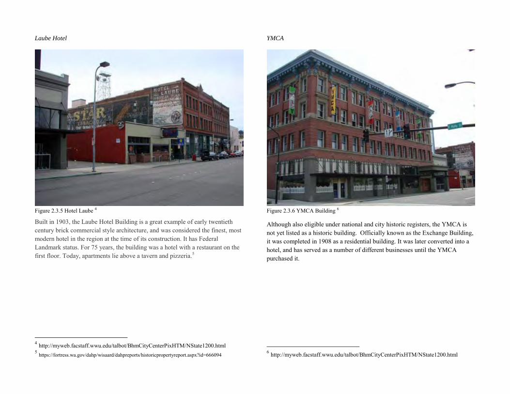
Laube Hotel
Figure 2.3.5 Hotel Laube 4
Built in 1903, the Laube Hotel Building is a great example of early twentieth century brick commercial style architecture, and was considered the finest, most modern hotel in the region at the time of its construction. It has Federal Landmark status. For 75 years, the building was a hotel with a restaurant on the first floor. Today, apartments lie above a tavern and pizzeria.5
4 http://myweb.facstaff.wwu.edu/talbot/BhmCityCenterPixHTM/NState1200.html 5 https://fortress.wa.gov/dahp/wisaard/dahpreports/historicpropertyreport.aspx?id=666094
YMCA
Figure 2.3.6 YMCA Building 6
Although also eligible under national and city historic registers, the YMCA is not yet listed as a historic building. Officially known as the Exchange Building, it was completed in 1908 as a residential building. It was later converted into a hotel, and has served as a number of different businesses until the YMCA purchased it.
6 http://myweb.facstaff.wwu.edu/talbot/BhmCityCenterPixHTM/NState1200.html
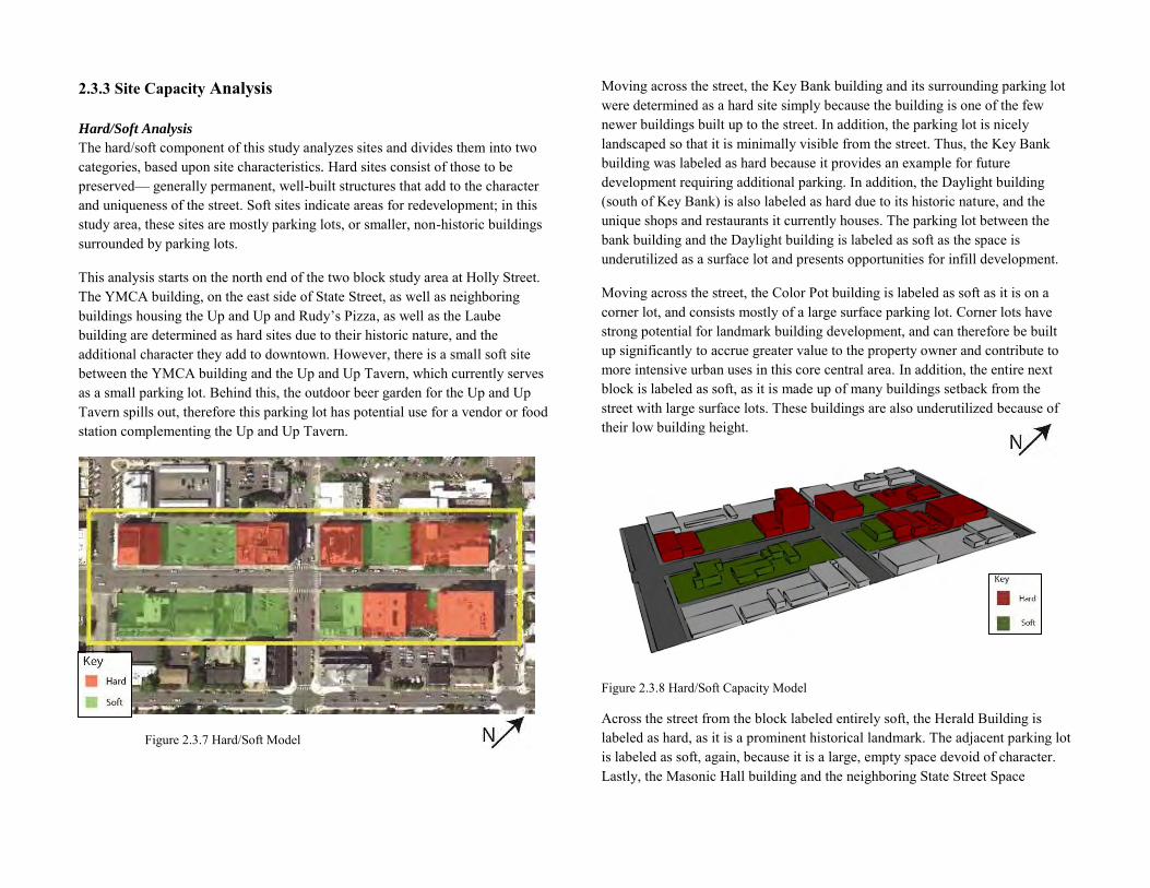
2.3.3 Site Capacity Analysis Hard/Soft Analysis
The hard/soft component of this study analyzes sites and divides them into two categories, based upon site characteristics. Hard sites consist of those to be preserved— generally permanent, well-built structures that add to the character and uniqueness of the street. Soft sites indicate areas for redevelopment; in this study area, these sites are mostly parking lots, or smaller, non-historic buildings surrounded by parking lots.
This analysis starts on the north end of the two block study area at Holly Street. The YMCA building, on the east side of State Street, as well as neighboring buildings housing the Up and Up and Rudy’s Pizza, as well as the Laube building are determined as hard sites due to their historic nature, and the additional character they add to downtown. However, there is a small soft site between the YMCA building and the Up and Up Tavern, which currently serves as a small parking lot. Behind this, the outdoor beer garden for the Up and Up Tavern spills out, therefore this parking lot has potential use for a vendor or food station complementing the Up and Up Tavern.
Figure 2.3.7 Hard/Soft Model
Moving across the street, the Key Bank building and its surrounding parking lot were determined as a hard site simply because the building is one of the few newer buildings built up to the street. In addition, the parking lot is nicely landscaped so that it is minimally visible from the street. Thus, the Key Bank building was labeled as hard because it provides an example for future development requiring additional parking. In addition, the Daylight building (south of Key Bank) is also labeled as hard due to its historic nature, and the unique shops and restaurants it currently houses. The parking lot between the bank building and the Daylight building is labeled as soft as the space is underutilized as a surface lot and presents opportunities for infill development.
Moving across the street, the Color Pot building is labeled as soft as it is on a corner lot, and consists mostly of a large surface parking lot. Corner lots have strong potential for landmark building development, and can therefore be built up significantly to accrue greater value to the property owner and contribute to more intensive urban uses in this core central area. In addition, the entire next block is labeled as soft, as it is made up of many buildings setback from the street with large surface lots. These buildings are also underutilized because of their low building height.
Figure 2.3.8 Hard/Soft Capacity Model
Across the street from the block labeled entirely soft, the Herald Building is labeled as hard, as it is a prominent historical landmark. The adjacent parking lot is labeled as soft, again, because it is a large, empty space devoid of character. Lastly, the Masonic Hall building and the neighboring State Street Space
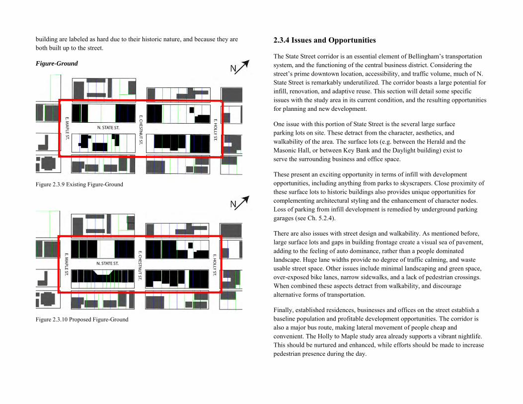
building are labeled as hard due to their historic nature, and because they are both built up to the street.
Figure-Ground
Figure 2.3.9 Existing Figure-Ground
Figure 2.3.10 Proposed Figure-Ground
2.3.4 Issues and Opportunities
The State Street corridor is an essential element of Bellingham’s transportation system, and the functioning of the central business district. Considering the street’s prime downtown location, accessibility, and traffic volume, much of N. State Street is remarkably underutilized. The corridor boasts a large potential for infill, renovation, and adaptive reuse. This section will detail some specific issues with the study area in its current condition, and the resulting opportunities for planning and new development.
One issue with this portion of State Street is the several large surface parking lots on site. These detract from the character, aesthetics, and walkability of the area. The surface lots (e.g. between the Herald and the Masonic Hall, or between Key Bank and the Daylight building) exist to serve the surrounding business and office space.
These present an exciting opportunity in terms of infill with development opportunities, including anything from parks to skyscrapers. Close proximity of these surface lots to historic buildings also provides unique opportunities for complementing architectural styling and the enhancement of character nodes. Loss of parking from infill development is remedied by underground parking garages (see Ch. 5.2.4).
There are also issues with street design and walkability. As mentioned before, large surface lots and gaps in building frontage create a visual sea of pavement, adding to the feeling of auto dominance, rather than a people dominated landscape. Huge lane widths provide no degree of traffic calming, and waste usable street space. Other issues include minimal landscaping and green space, over-exposed bike lanes, narrow sidewalks, and a lack of pedestrian crossings. When combined these aspects detract from walkability, and discourage alternative forms of transportation.
Finally, established residences, businesses and offices on the street establish a baseline population and profitable development opportunities. The corridor is also a major bus route, making lateral movement of people cheap and convenient. The Holly to Maple study area already supports a vibrant nightlife. This should be nurtured and enhanced, while efforts should be made to increase pedestrian presence during the day.
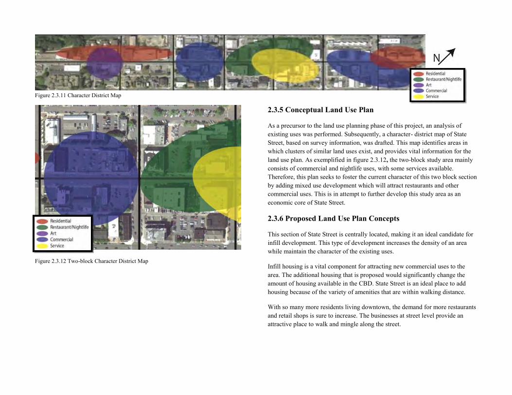
Figure 2.3.11 Character District Map
Figure 2.3.12 Two-block Character District Map
2.3.5 Conceptual Land Use Plan
As a precursor to the land use planning phase of this project, an analysis of existing uses was performed. Subsequently, a character- district map of State Street, based on survey information, was drafted. This map identifies areas in which clusters of similar land uses exist, and provides vital information for the land use plan. As exemplified in figure 2.3.12, the two-block study area mainly consists of commercial and nightlife uses, with some services available. Therefore, this plan seeks to foster the current character of this two block section by adding mixed use development which will attract restaurants and other commercial uses. This is in attempt to further develop this study area as an economic core of State Street.
2.3.6 Proposed Land Use Plan Concepts
This section of State Street is centrally located, making it an ideal candidate for infill development. This type of development increases the density of an area while maintain the character of the existing uses.
Infill housing is a vital component for attracting new commercial uses to the area. The additional housing that is proposed would significantly change the amount of housing available in the CBD. State Street is an ideal place to add housing because of the variety of amenities that are within walking distance.
With so many more residents living downtown, the demand for more restaurants and retail shops is sure to increase. The businesses at street level provide an attractive place to walk and mingle along the street.
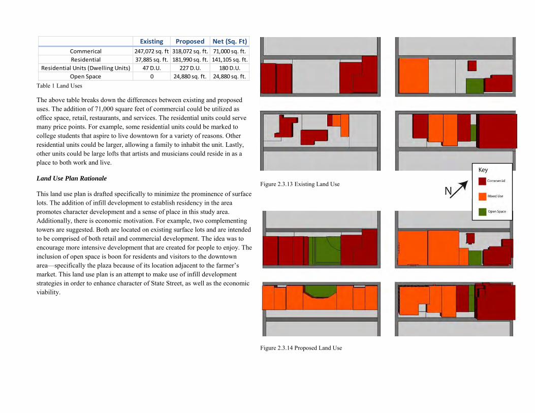
Existing Proposed Net (Sq. Ft)
Commerical 247,072 sq. ft 318,072 sq. ft. 71,000 sq. ft.
Residential 37,885 sq. ft. 181,990 sq. ft. 141,105 sq. ft.
Residential Units (Dwelling Units) 47 D.U. 227 D.U. 180 D.U.
Open Space 0 24,880 sq. ft. 24,880 sq. ft. Table 1 Land Uses
The above table breaks down the differences between existing and proposed uses. The addition of 71,000 square feet of commercial could be utilized as office space, retail, restaurants, and services. The residential units could serve many price points. For example, some residential units could be marked to college students that aspire to live downtown for a variety of reasons. Other residential units could be larger, allowing a family to inhabit the unit. Lastly, other units could be large lofts that artists and musicians could reside in as a place to both work and live.
Land Use Plan Rationale
This land use plan is drafted specifically to minimize the prominence of surface lots. The addition of infill development to establish residency in the area promotes character development and a sense of place in this study area. Additionally, there is economic motivation. For example, two complementing towers are suggested. Both are located on existing surface lots and are intended to be comprised of both retail and commercial development. The idea was to encourage more intensive development that are created for people to enjoy. The inclusion of open space is boon for residents and visitors to the downtown area—specifically the plaza because of its location adjacent to the farmer’s market. This land use plan is an attempt to make use of infill development strategies in order to enhance character of State Street, as well as the economic viability.
Figure 2.3.13 Existing Land Use
Figure 2.3.14 Proposed Land Use
Street View Elevations
Figure 2.3.15 Street View Elevation of east side of State between E. Holly and E. Chestnut
Figure 2.3.17 Street view elevation of east side of State between E. Holly and E. Chestnut
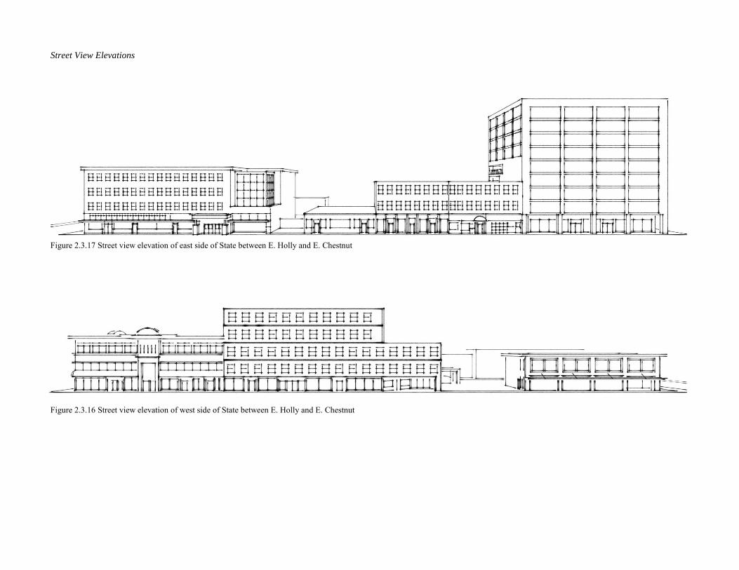
Figure 2.3.16 Street view elevation of west side of State between E. Holly and E. Chestnut
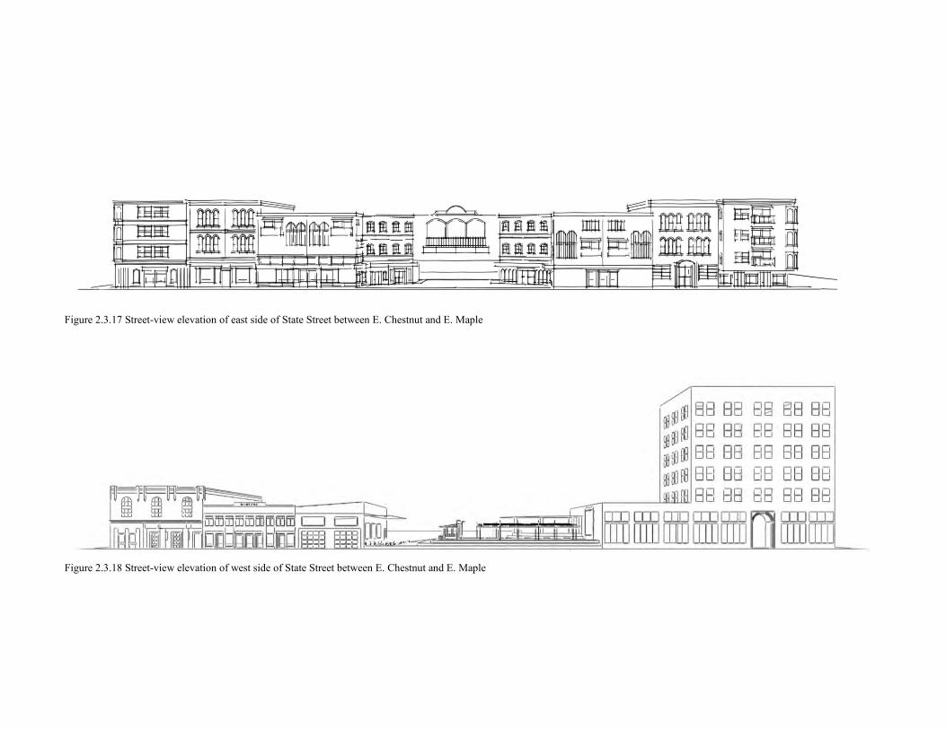
Figure 2.3.17 Street-view elevation of east side of State Street between E. Chestnut and E. Maple
Figure 2.3.18 Street-view elevation of west side of State Street between E. Chestnut and E. Maple
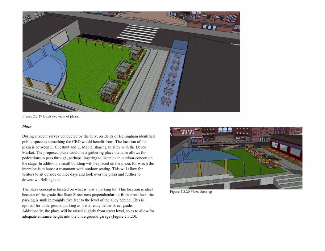
Plaza
During a recent survey conducted by the City, residents of Bellingham identified public space as something the CBD would benefit from. The location of this plaza is between E. Chestnut and E. Maple, sharing an alley with the Depot Market. The proposed plaza would be a gathering place that also allows for pedestrians to pass through, perhaps lingering to listen to an outdoor concert on the stage. In addition, a small building will be placed on the plaza, for which the intention is to house a restaurant with outdoor seating. This will allow for visitors to sit outside on nice days and look over the plaza and further to downtown Bellingham.
The plaza concept is located on what is now a parking lot. This location is ideal because of the grade that State Street runs perpendicular to; from street level the parking is sunk in roughly five feet to the level of the alley behind. This is optimal for underground parking as it is already below street grade. Additionally, the plaza will be raised slightly from street level, so as to allow for adequate entrance height into the underground garage (Figure 2.3.20).
Figure 2.3.20 Plaza close-up
Figure 2.3.19 Birds eye view of plaza.
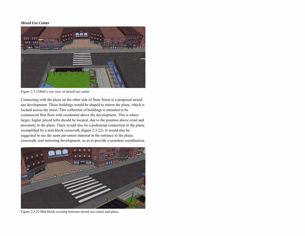
Mixed Use Center
Figure 2.3.21Bird’s eye view of mixed use center
Connecting with the plaza on the other side of State Street is a proposed mixed use development. These buildings would be shaped to mirror the plaza, which is located across the street. This collection of buildings is intended to be commercial first floor with residential above the development. This is where larger, higher priced lofts should be located, due to the position above retail and proximity to the plaza. There would also be a pedestrian connection to the plaza, exemplified by a mid-block crosswalk (figure 2.3.22). It would also be suggested to use the same pavement material in the entrance to the plaza, crosswalk, and mirroring development, so as to provide a seamless coordination.
Figure 2.3.22 Mid-block crossing between mixed use center and plaza.
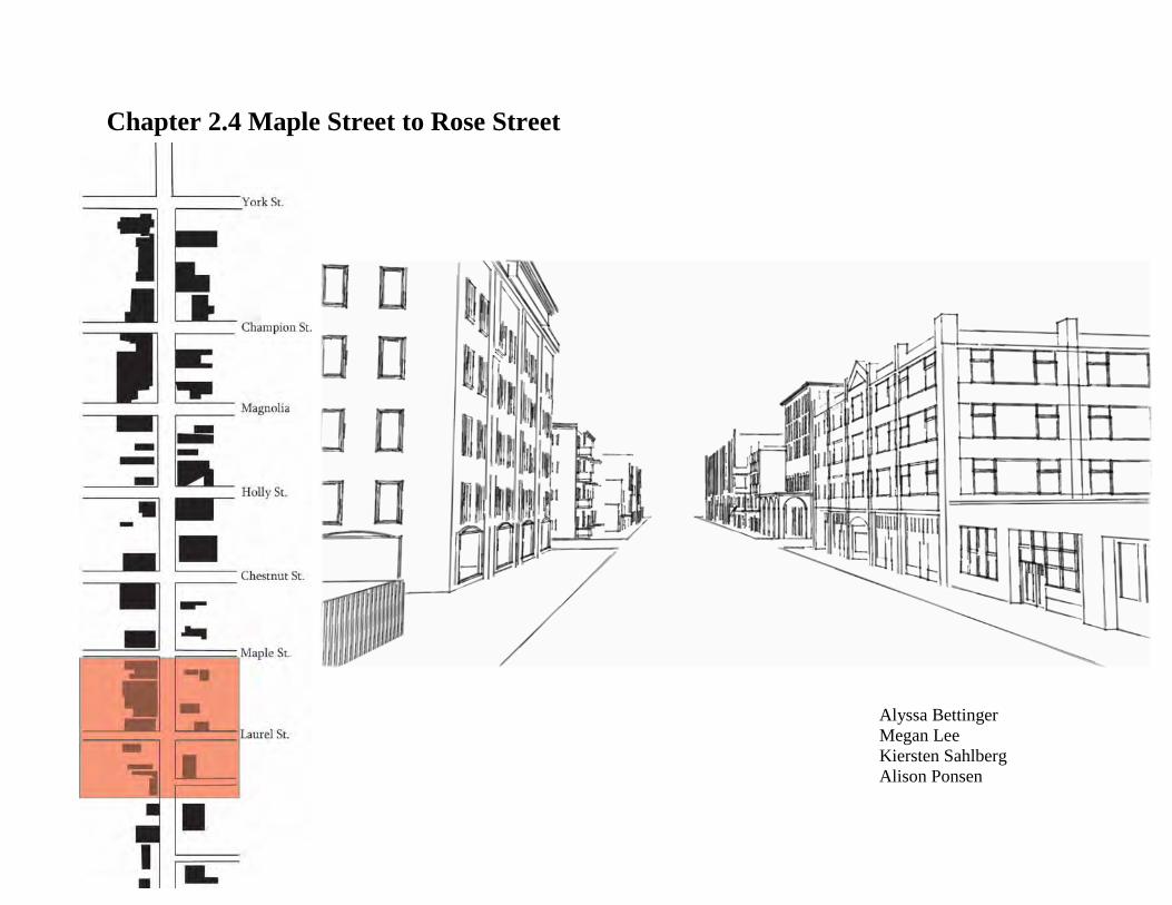
Chapter 2.4 Maple Street to Rose Street
Alyssa Bettinger Megan Lee Kiersten Sahlberg Alison Ponsen
2.4.1 Vision, Goal, and Objective Statements
The two block radius between Maple Street and Rose Street presents idealistic conditions for the growth and development needed to reach the City of Bellingham’s infill and density goals for the coming years. Central to the city’s goal for infill is a commitment to environmental sustainability, including the promise of walkability. This study section provides a fair amount of amenities one may need within comfortable walking distance of their living space so that they may rarely find it necessary to drive around town for errands. In addition, new infill buildings should be been designed with livability in mind. Each building provides for retail on the ground floor supporting shopping, dining, or entertainment. This allows pedestrians may enjoy buildings that would otherwise be private. Finally, each space in this two block study area has been thoughtfully and carefully designed to create a lively pedestrian atmosphere that is comfortable and provides countless opportunities for pleasure and employment.
The vision for this two block radius is to enhance the existing character of the area, while also meeting the City of Bellingham’s goals for infill and greater density. In order to bring more people to the retail hubs of downtown Bellingham, more people need to be living in downtown Bellingham. To accommodate these new living spaces, the report identifies several building sites that should be cleared for redevelopment. Certain properties are underutilized and do not enhance the existing character of the State Street corridor. In addition to more residential and retail spaces, increased density requires the presence of pedestrian amenities including pedestrian sidewalk spaces, sidewalks lined with trees, and human-scale lighting. These design tactics promote the movement of people throughout State Street and create an atmosphere that is animated and inviting during all hours of the day and night.
2.4.2 Land Use Description
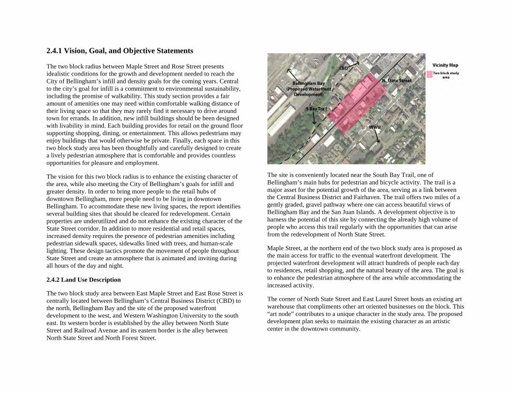
The two block study area between East Maple Street and East Rose Street is centrally located between Bellingham’s Central Business District (CBD) to the north, Bellingham Bay and the site of the proposed waterfront development to the west, and Western Washington University to the south east. Its western border is established by the alley between North State Street and Railroad Avenue and its eastern border is the alley between North State Street and North Forest Street.
The site is conveniently located near the South Bay Trail, one of Bellingham’s main hubs for pedestrian and bicycle activity. The trail is a major asset for the potential growth of the area, serving as a link between the Central Business District and Fairhaven. The trail offers two miles of a gently graded, gravel pathway where one can access beautiful views of Bellingham Bay and the San Juan Islands. A development objective is to harness the potential of this site by connecting the already high volume of people who access this trail regularly with the opportunities that can arise from the redevelopment of North State Street.
Maple Street, at the northern end of the two block study area is proposed as the main access for traffic to the eventual waterfront development. The projected waterfront development will attract hundreds of people each day to residences, retail shopping, and the natural beauty of the area. The goal is to enhance the pedestrian atmosphere of the area while accommodating the increased activity.
The corner of North State Street and East Laurel Street hosts an existing art warehouse that compliments other art oriented businesses on the block. This “art node” contributes to a unique character in the study area. The proposed development plan seeks to maintain the existing character as an artistic center in the downtown community.
The dining and entertainment scene is another focal point in this two block study area. Within it there are several opportunities to experience dining that are distinctly Bellingham, for example, Pepper Sisters. These businesses can be located in figure 2.4.1 for orientation. Likewise, local bars like The Honeymoon, The Red Light and The Green Frog offer distinct experiences like gourmet grilled cheese sandwiches, locally made mead (honey wine), and local live music. These current establishments bring liveliness to North State Street and offer inspiration for future successful business development.
Several landmarks exist in the two block study section between Maple Street and Rose Street that are historic foundations to the creation of a cohesive area that is lively, exciting, and interesting to downtown residents and visitors. The Morse Hardware Co. building, located at 1025 North State Street, has been in the area since 1884.Morse Distribution Inc. and Industrial Supply operated as one of the most successful businesses in Bellingham until 1982. Currently, the remarkable building sits vacant. It is a great example of a building that should be utilized as to reflect Bellingham’s history. It has recently been proposed that the entrance to the alley west of N. State Street at Maple Street be named Morse Alley in honor of this distinct historic landmark. A proposed archway entrance will welcome visitors to the alley, which connects to the South Bay Trail. The design concept proposed seeks to build upon the assets provided by the South Bay Trail, the art node, and the dining and entertainment node.
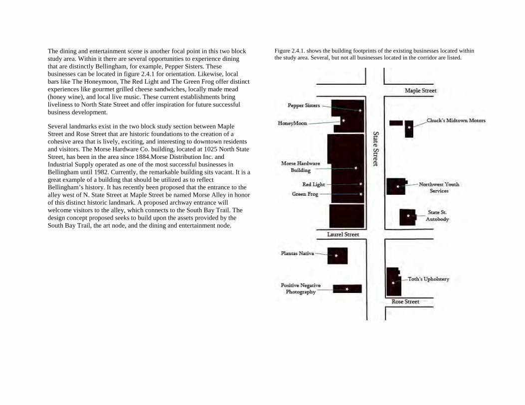
Figure 2.4.1. shows the building footprints of the existing businesses located within the study area. Several, but not all businesses located in the corridor are listed.
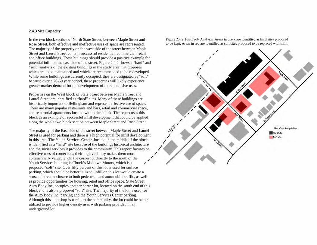
2.4.3 Site Capacity
In the two block section of North State Street, between Maple Street and Rose Street, both effective and ineffective uses of space are represented. The majority of the property on the west side of the street between Maple Street and Laurel Street contain successful residential, commercial, retail and office buildings. These buildings should provide a positive example for potential infill on the east side of the street. Figure 2.4.2 shows a “hard” and “soft” analysis of the existing buildings in the study area that proposes which are to be maintained and which are recommended to be redeveloped. While some buildings are currently occupied, they are designated as “soft” because over a 20-50 year period, these properties will likely experience greater market demand for the development of more intensive uses.
Properties on the West block of State Street between Maple Street and Laurel Street are identified as “hard” sites. Many of these buildings are historically important to Bellingham and represent effective use of space. There are many popular restaurants and bars, retail and commercial space, and residential apartments located within this block. The report uses this block as an example of successful infill development that could be applied along the whole two block section between Maple Street and Rose Street.
The majority of the East side of the street between Maple Street and Laurel Street is used for parking and there is a high potential for infill development in this area. The Youth Services Center, located in the middle of the block, is identified as a “hard” site because of the buildings historical architecture and the social services it provides to the community. This report focuses on effective uses of corner lots; their high visibility makes them more commercially valuable. On the corner lot directly to the north of the Youth Services building is Chuck’s Midtown Motors, which is a proposed “soft” site. Over fifty percent of this lot is used for surface parking, which should be better utilized. Infill on this lot would create a sense of street enclosure to both pedestrian and automobile traffic, as well as provide opportunities for housing, retail and office space. State Street Auto Body Inc. occupies another corner lot, located on the south end of this block and is also a proposed “soft” site. The majority of the lot is used for the Auto Body Inc. parking and the Youth Services Center parking. Although this auto shop is useful to the community, the lot could be better utilized to provide higher density uses with parking provided in an underground lot.
Figure 2.4.2. Hard/Soft Analysis. Areas in black are identified as hard sites proposed to be kept. Areas in red are identified as soft sites proposed to be replaced with infill.
Currently, local artists occupy a photography studio and warehouse with native plant garden on the southwest corner lot of State Street and Laurel Street. The warehouse is deteriorating and has been identified as a “soft” site for redevelopment. As discussed in section 2.4.6, a new building on this lot that should promote the existing art scene while accommodating more intensive uses.
The Southeast corner of Laurel Street and State Street is currently occupied by Boo’s Dog Parlor and a large parking lot owned by U-Haul. This lot has been identified as a “soft” site because it is underutilized as a surface parking lot, is not aesthetically appealing, and does not contribute to the strong urban design character of State Street. Directly south of this lot is a proposed “hard” site consisting of two historical buildings that provide well utilized commercial and residential space.
2.4.4 Opportunities and Problems Table
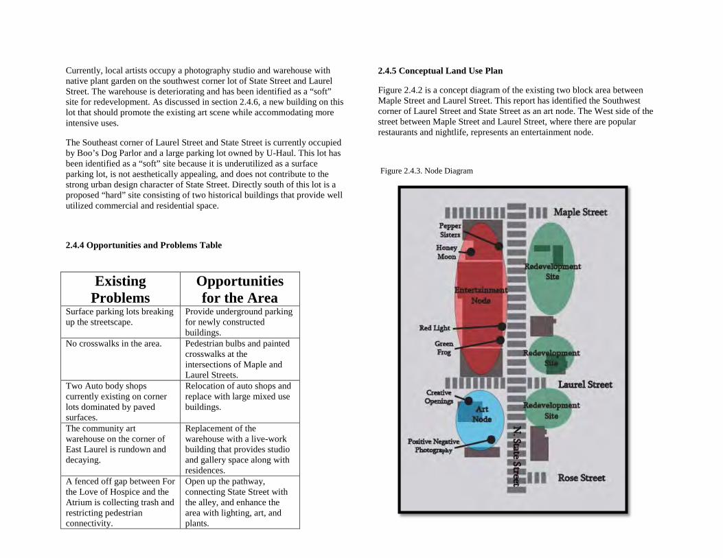
2.4.5 Conceptual Land Use Plan
Figure 2.4.2 is a concept diagram of the existing two block area between Maple Street and Laurel Street. This report has identified the Southwest corner of Laurel Street and State Street as an art node. The West side of the street between Maple Street and Laurel Street, where there are popular restaurants and nightlife, represents an entertainment node.
Figure 2.4.3. Node Diagram
Existing Problems
Opportunities for the Area
Surface parking lots breaking up the streetscape.
Provide underground parking for newly constructed buildings.
No crosswalks in the area. Pedestrian bulbs and painted crosswalks at the intersections of Maple and Laurel Streets.
Two Auto body shops currently existing on corner lots dominated by paved surfaces.
Relocation of auto shops and replace with large mixed use buildings.
The community art warehouse on the corner of East Laurel is rundown and decaying.
Replacement of the warehouse with a live-work building that provides studio and gallery space along with residences.
A fenced off gap between For the Love of Hospice and the Atrium is collecting trash and restricting pedestrian connectivity.
Open up the pathway, connecting State Street with the alley, and enhance the area with lighting, art, and plants.
2.4.6 Proposed Land Use Concepts
The two block study area of North State Street, between Maple Street and Rose Street, provides multiple opportunities for new development. This section of North State Street is in close proximity to the heart of downtown and is about six blocks southwest of Western Washington University. This makes it an extremely desirable location for student occupancy. To better utilize the space between Maple Street and Rose Street, this plan recommends five new buildings to be constructed in the two block section that provide for more residential units.
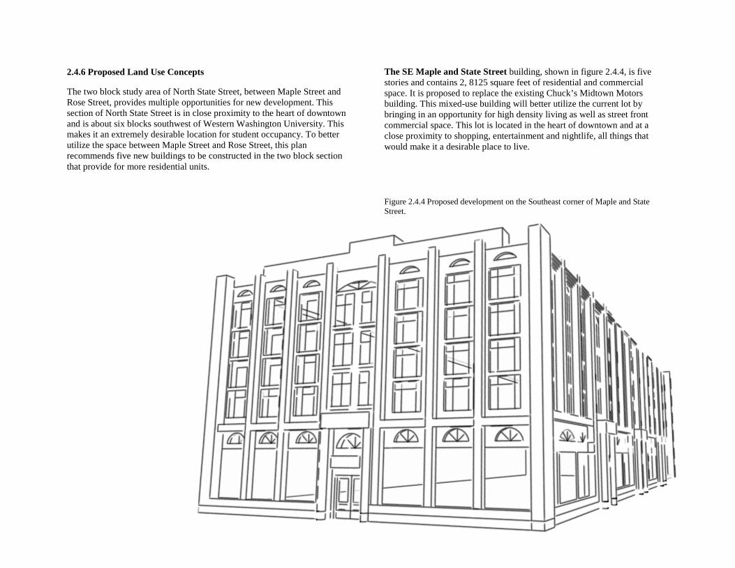
The SE Maple and State Street building, shown in figure 2.4.4, is five stories and contains 2, 8125 square feet of residential and commercial space. It is proposed to replace the existing Chuck’s Midtown Motors building. This mixed-use building will better utilize the current lot by bringing in an opportunity for high density living as well as street front commercial space. This lot is located in the heart of downtown and at a close proximity to shopping, entertainment and nightlife, all things that would make it a desirable place to live.
Figure 2.4.4 Proposed development on the Southeast corner of Maple and State Street.
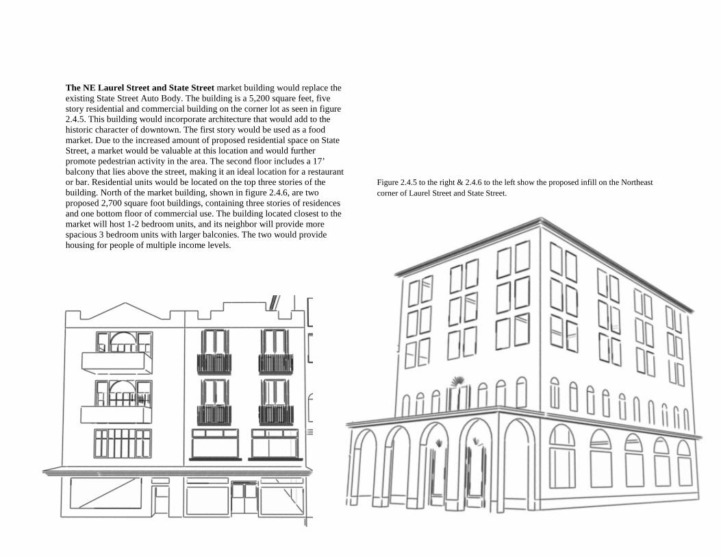
The NE Laurel Street and State Street market building would replace the existing State Street Auto Body. The building is a 5,200 square feet, five story residential and commercial building on the corner lot as seen in figure 2.4.5. This building would incorporate architecture that would add to the historic character of downtown. The first story would be used as a food market. Due to the increased amount of proposed residential space on State Street, a market would be valuable at this location and would further promote pedestrian activity in the area. The second floor includes a 17’ balcony that lies above the street, making it an ideal location for a restaurant or bar. Residential units would be located on the top three stories of the building. North of the market building, shown in figure 2.4.6, are two proposed 2,700 square foot buildings, containing three stories of residences and one bottom floor of commercial use. The building located closest to the market will host 1-2 bedroom units, and its neighbor will provide more spacious 3 bedroom units with larger balconies. The two would provide housing for people of multiple income levels.
Figure 2.4.5 to the right & 2.4.6 to the left show the proposed infill on the Northeast corner of Laurel Street and State Street.
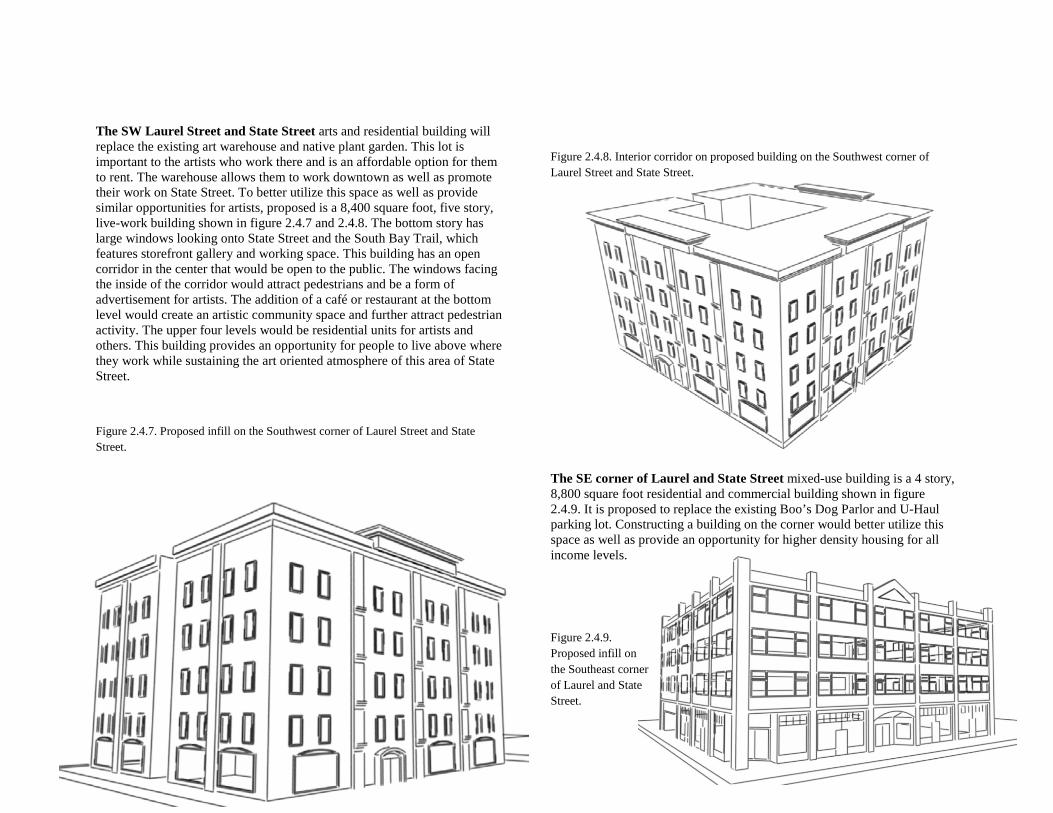
The SW Laurel Street and State Street arts and residential building will replace the existing art warehouse and native plant garden. This lot is important to the artists who work there and is an affordable option for them to rent. The warehouse allows them to work downtown as well as promote their work on State Street. To better utilize this space as well as provide similar opportunities for artists, proposed is a 8,400 square foot, five story, live-work building shown in figure 2.4.7 and 2.4.8. The bottom story has large windows looking onto State Street and the South Bay Trail, which features storefront gallery and working space. This building has an open corridor in the center that would be open to the public. The windows facing the inside of the corridor would attract pedestrians and be a form of advertisement for artists. The addition of a café or restaurant at the bottom level would create an artistic community space and further attract pedestrian activity. The upper four levels would be residential units for artists and others. This building provides an opportunity for people to live above where they work while sustaining the art oriented atmosphere of this area of State Street.
Figure 2.4.7. Proposed infill on the Southwest corner of Laurel Street and State Street.
Figure 2.4.8. Interior corridor on proposed building on the Southwest corner of Laurel Street and State Street.
The SE corner of Laurel and State Street mixed-use building is a 4 story, 8,800 square foot residential and commercial building shown in figure 2.4.9. It is proposed to replace the existing Boo’s Dog Parlor and U-Haul parking lot. Constructing a building on the corner would better utilize this space as well as provide an opportunity for higher density housing for all income levels.
Figure 2.4.9. Proposed infill on the Southeast corner of Laurel and State Street.
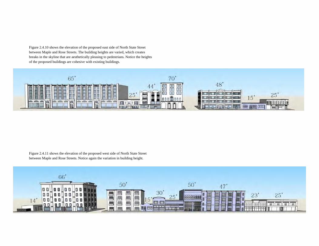
Figure 2.4.10 shows the elevation of the proposed east side of North State Street between Maple and Rose Streets. The building heights are varied, which creates breaks in the skyline that are aesthetically pleasing to pedestrians. Notice the heights of the proposed buildings are cohesive with existing buildings.
Figure 2.4.11 shows the elevation of the proposed west side of North State Street between Maple and Rose Streets. Notice again the variation in building height.
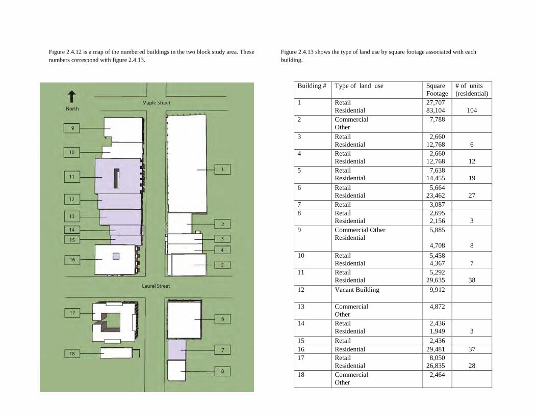
Figure 2.4.12 is a map of the numbered buildings in the two block study area. These numbers correspond with figure 2.4.13.
Figure 2.4.13 shows the type of land use by square footage associated with each building.
Building # Type of land use Square Footage
# of units (residential)
1 Retail Residential
27,707 83,104
104
2 Commercial Other
7,788
3 Retail Residential
2,660 12,768
6
4 Retail Residential
2,660 12,768
12
5 Retail Residential
7,638 14,455
19
6 Retail Residential
5,664 23,462
27
7 Retail 3,087 8 Retail
Residential 2,695 2,156
3
9 Commercial Other Residential
5,885 4,708
8 10 Retail
Residential 5,458 4,367
7
11 Retail Residential
5,292 29,635
38
12 Vacant Building 9,912
13 Commercial Other
4,872
14 Retail Residential
2,436 1,949
3
15 Retail 2,436 16 Residential 29,481 37 17 Retail
Residential 8,050 26,835
28
18 Commercial Other
2,464
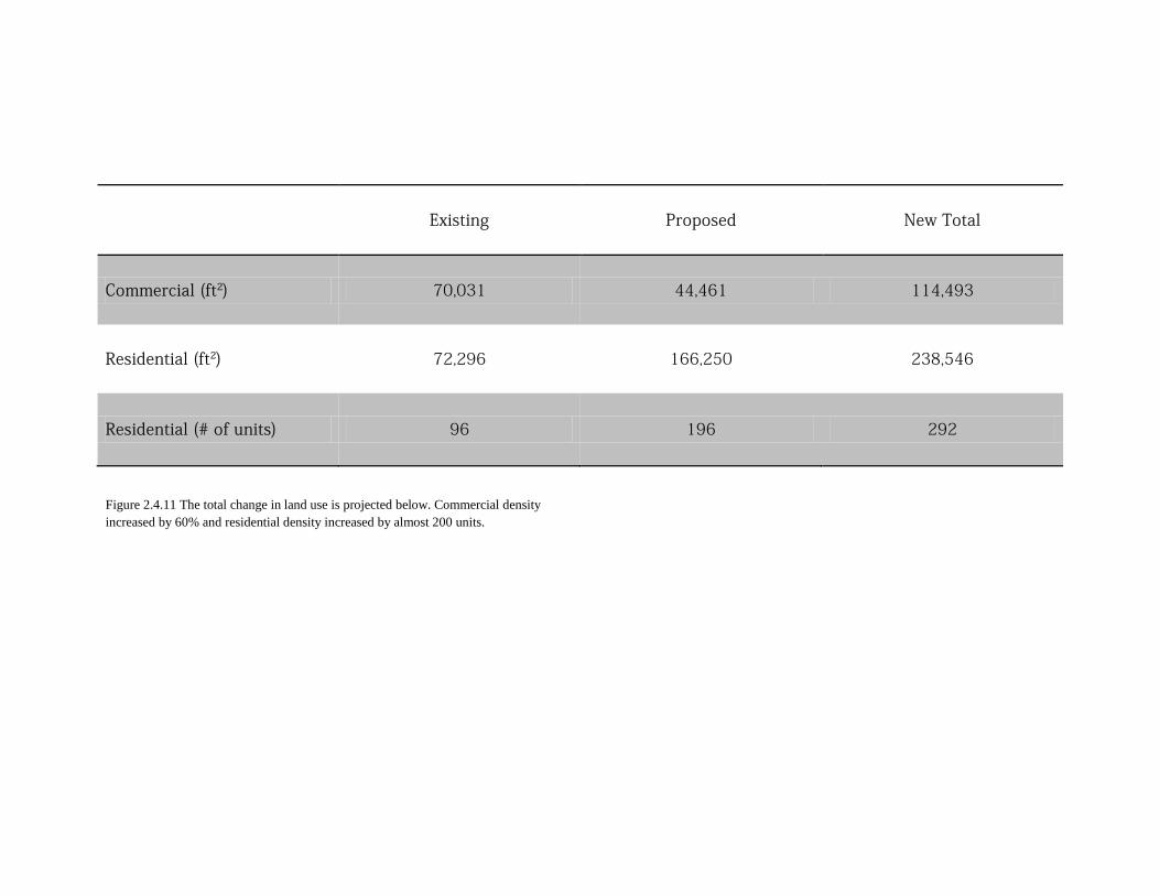
Figure 2.4.11 The total change in land use is projected below. Commercial density increased by 60% and residential density increased by almost 200 units.
Existing Proposed New Total
Commercial (ft2) 70,031 44,461 114,493
Residential (ft2) 72,296 166,250 238,546
Residential (# of units) 96 196 292
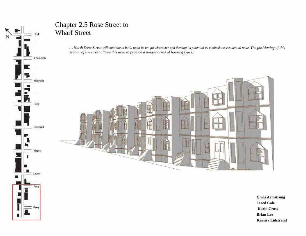
Chapter 2.5 Rose Street to Wharf Street
… North State Street will continue to build upon its unique character and develop its potential as a mixed use residential node. The positioning of this section of the street allows this area to provide a unique array of housing types…
Chris Armstrong Jared Cole Karin Cross Brian Lee Karissa Lidstrand
Table of Contents 2.5.1 Vision Statement 2.5.2 Land Use Description Vicinity Map 2.5.3 Site Capacity Infill Potential Hard/Soft Analysis Figure Ground 2.5.4 Opportunities and Restrictions Opportunities South Bay Trail Constraints Roundabout 2.5.5 Proposed Land Use Concepts Existing Buildings Infill Buildings Parking Solutions Connecting the South Bay Trail
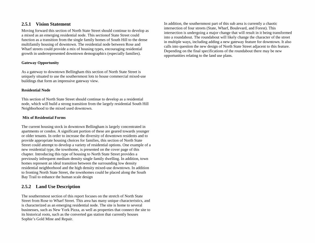
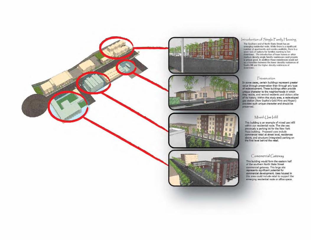
2.5.1 Vision Statement Moving forward this section of North State Street should continue to develop as a mixed as an emerging residential node. This sectionof State Street could function as a transition from the single family homes of South Hill to the dense multifamily housing of downtown. The residential node between Rose and Wharf streets could provide a mix of housing types, encouraging residential growth in underrepresented downtown demographics (especially families). Gateway Opportunity As a gateway to downtown Bellingham this section of North State Street is uniquely situated to use the southernmost lots to house commercial mixed-use buildings that form an impressive gateway view. Residential Node This section of North State Street should continue to develop as a residential node, which will build a strong transition from the largely residential South Hill Neighborhood to the mixed used downtown. Mix of Residential Forms The current housing stock in downtown Bellingham is largely concentrated in apartments or condos. A significant portion of these are geared towards younger or older tenants. In order to increase the diversity of downtown residents and to provide appropriate housing choices for families, this section of North State Street could attempt to develop a variety of residential options. One example of a new residential type, the townhome, is presented on the cover page of this chapter. Introducing this type of housing to North State Street provides a previously infrequent medium density single family dwelling. In addition, town homes represent an ideal transition between the surrounding low density residential neighborhood and the high density mixed-use downtown. In addition to fronting North State Street, the townhomes could be placed along the South Bay Trail to enhance the human scale design 2.5.2 Land Use Description The southernmost section of this report focuses on the stretch of North State Street from Rose to Wharf Street. This area has many unique characteristics, and is characterized as an emerging residential node. The site is home to several businesses, such as New York Pizza, as well as properties that connect the site to its historical roots, such as the converted gas station that currently houses Sophie’s Gold Mine and Repair.
In addition, the southernmost part of this sub area is currently a chaotic intersection of four streets (State, Wharf, Boulevard, and Forest). This intersection is undergoing a major change that will result in it being transformed into a roundabout. The roundabout will likely change the character of the street in multiple ways, including adding a new gateway feature for downtown. It also calls into question the new design of North State Street adjacent to this feature. Depending on the final specifications of the roundabout there may be new opportunities relating to the land use plans.
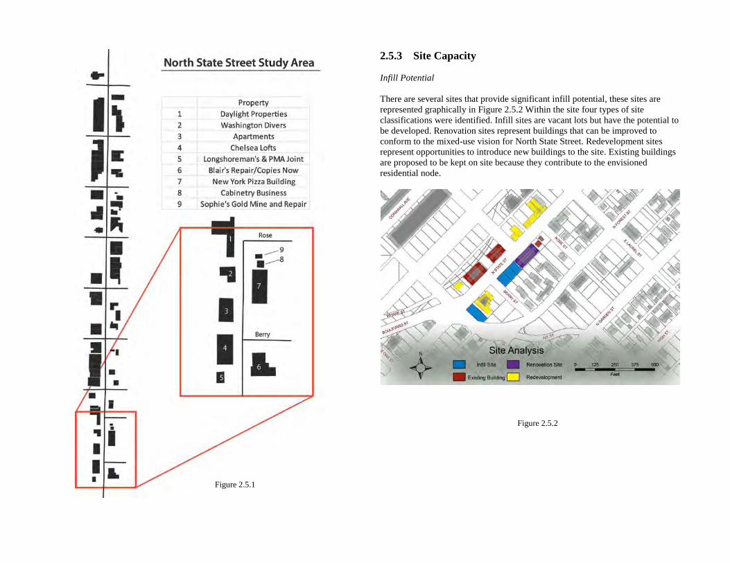
2.5.3 Site Capacity Infill Potential There are several sites that provide significant infill potential, these sites are represented graphically in Figure 2.5.2 Within the site four types of site classifications were identified. Infill sites are vacant lots but have the potential to be developed. Renovation sites represent buildings that can be improved to conform to the mixed-use vision for North State Street. Redevelopment sites represent opportunities to introduce new buildings to the site. Existing buildings are proposed to be kept on site because they contribute to the envisioned residential node.
Figure 2.5.1
Figure 2.5.2
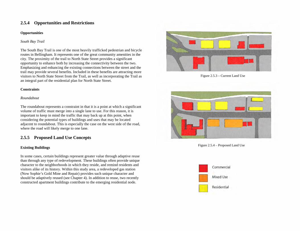
2.5.4 Opportunities and Restrictions Opportunities South Bay Trail The South Bay Trail is one of the most heavily trafficked pedestrian and bicycle routes in Bellingham. It represents one of the great community amenities in the city. The proximity of the trail to North State Street provides a significant opportunity to enhance both by increasing the connectivity between the two. Emphasizing and enhancing the existing connections between the street and the trail may provide several benefits. Included in these benefits are attracting more visitors to North State Street from the Trail, as well as incorporating the Trail as an integral part of the residential plan for North State Street. Constraints Roundabout The roundabout represents a constraint in that it is a point at which a significant volume of traffic must merge into a single lane to use. For this reason, it is important to keep in mind the traffic that may back up at this point, when considering the potential types of buildings and uses that may be located adjacent to roundabout. This is especially the case on the west side of the road, where the road will likely merge to one lane. 2.5.5 Proposed Land Use Concepts Existing Buildings In some cases, certain buildings represent greater value through adaptive reuse than through any type of redevelopment. These buildings often provide unique character to the neighborhoods in which they reside, and remind residents and visitors alike of its history. Within this study area, a redeveloped gas station (Now Sophie’s Gold Mine and Repair) provides such unique character and should be adaptively reused (see Chapter 4). In addition to reuse, two recently constructed apartment buildings contribute to the emerging residential node.
Figure 2.5.3 – Current Land Use
Figure 2.5.4 – Proposed Land Use
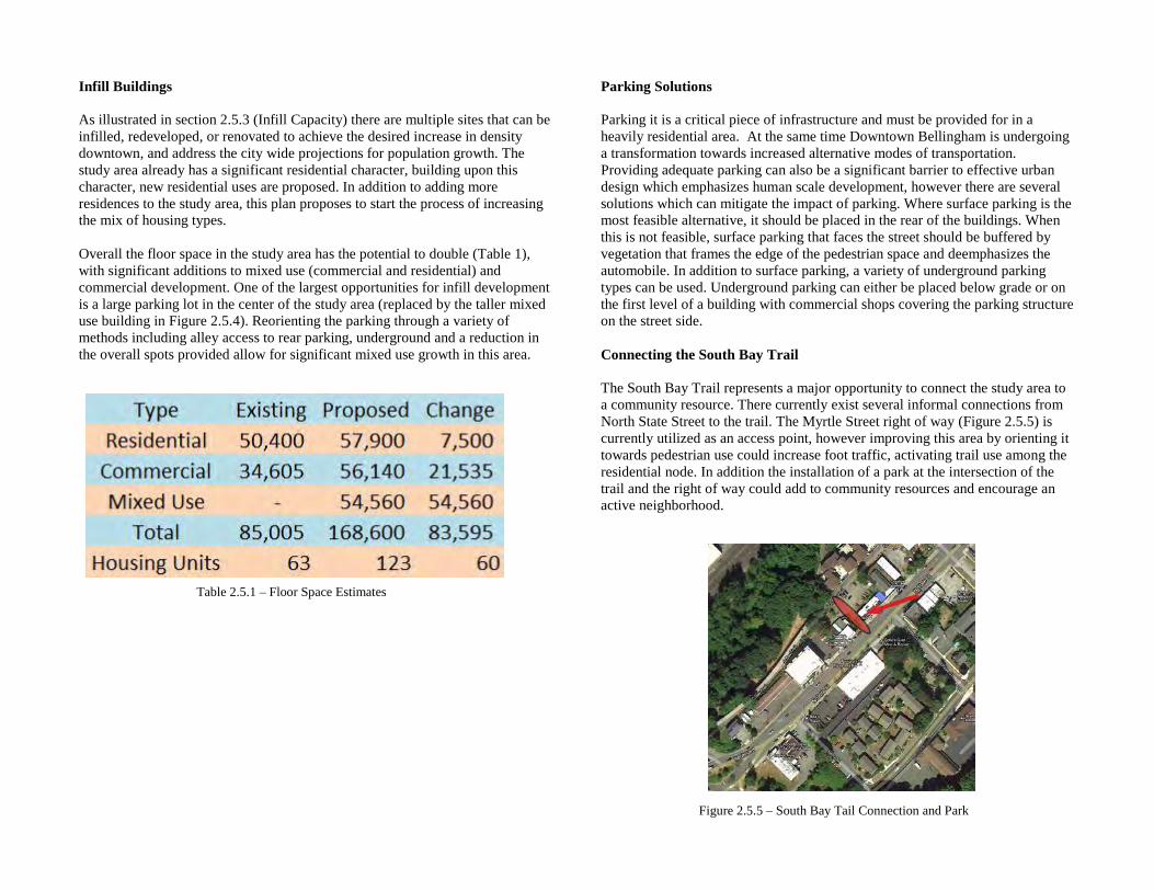
Infill Buildings As illustrated in section 2.5.3 (Infill Capacity) there are multiple sites that can be infilled, redeveloped, or renovated to achieve the desired increase in density downtown, and address the city wide projections for population growth. The study area already has a significant residential character, building upon this character, new residential uses are proposed. In addition to adding more residences to the study area, this plan proposes to start the process of increasing the mix of housing types. Overall the floor space in the study area has the potential to double (Table 1), with significant additions to mixed use (commercial and residential) and commercial development. One of the largest opportunities for infill development is a large parking lot in the center of the study area (replaced by the taller mixed use building in Figure 2.5.4). Reorienting the parking through a variety of methods including alley access to rear parking, underground and a reduction in the overall spots provided allow for significant mixed use growth in this area.
Parking Solutions Parking it is a critical piece of infrastructure and must be provided for in a heavily residential area. At the same time Downtown Bellingham is undergoing a transformation towards increased alternative modes of transportation. Providing adequate parking can also be a significant barrier to effective urban design which emphasizes human scale development, however there are several solutions which can mitigate the impact of parking. Where surface parking is the most feasible alternative, it should be placed in the rear of the buildings. When this is not feasible, surface parking that faces the street should be buffered by vegetation that frames the edge of the pedestrian space and deemphasizes the automobile. In addition to surface parking, a variety of underground parking types can be used. Underground parking can either be placed below grade or on the first level of a building with commercial shops covering the parking structure on the street side. Connecting the South Bay Trail The South Bay Trail represents a major opportunity to connect the study area to a community resource. There currently exist several informal connections from North State Street to the trail. The Myrtle Street right of way (Figure 2.5.5) is currently utilized as an access point, however improving this area by orienting it towards pedestrian use could increase foot traffic, activating trail use among the residential node. In addition the installation of a park at the intersection of the trail and the right of way could add to community resources and encourage an active neighborhood.
Table 2.5.1 – Floor Space Estimates
Figure 2.5.5 – South Bay Tail Connection and Park
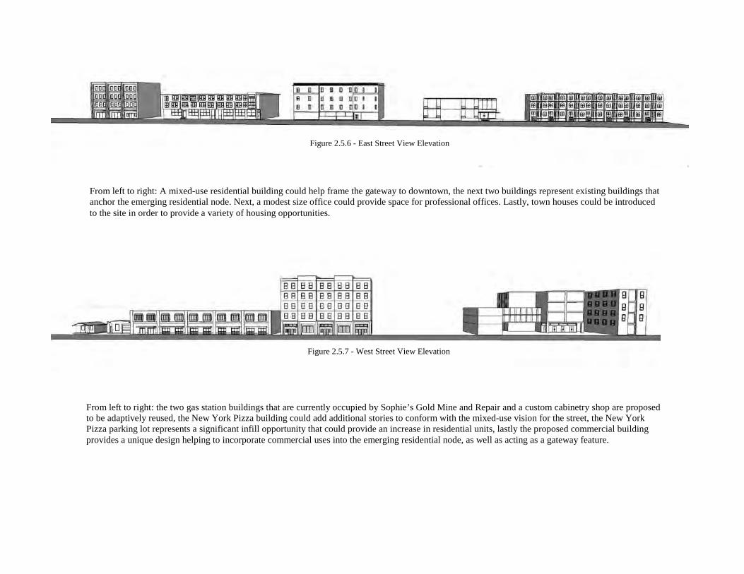
From left to right: the two gas station buildings that are currently occupied by Sophie’s Gold Mine and Repair and a custom cabinetry shop are proposed to be adaptively reused, the New York Pizza building could add additional stories to conform with the mixed-use vision for the street, the New York Pizza parking lot represents a significant infill opportunity that could provide an increase in residential units, lastly the proposed commercial building provides a unique design helping to incorporate commercial uses into the emerging residential node, as well as acting as a gateway feature.
From left to right: A mixed-use residential building could help frame the gateway to downtown, the next two buildings represent existing buildings that anchor the emerging residential node. Next, a modest size office could provide space for professional offices. Lastly, town houses could be introduced to the site in order to provide a variety of housing opportunities.
Figure 2.5.7 - West Street View Elevation
Figure 2.5.6 - East Street View Elevation
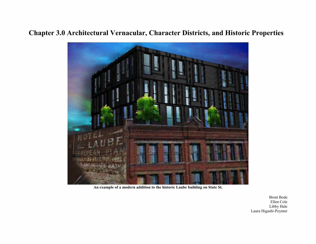
Chapter 3.0 Architectural Vernacular, Character Districts, and Historic Properties
An example of a modern addition to the historic Laube building on State St.
Brent Bode Ellen Cole
Libby Hale Laura Higashi-Poynter
3.1 Vision, Goal and Objective Statements Provide an architectural standard that future developers can
look to for guidance. Promote historic places to enrich the community’s
appreciation for the past. Encourage the use of character districts that relate to State St.
throughout downtown.
3.2 Problems and Opportunities Creating unity among N State St. is something that will not only
enhance the area itself, but the area around it. N State St. brings liveliness to it that can be enjoyed throughout the day and into the evening. Creating a cohesive vision from the northern most portion of the corridor to the southern end will continue to create a better flow for the citizens of Bellingham to enjoy the eastern boundary of the Central Business District.
The architectural guidelines are meant to help form and shape the continuing character of the buildings as they change throughout the many more thriving years that downtown Bellingham can enjoy. Although they are not meant to be set codes implemented into the master plan, they should be used as an overlay for architects to take into consideration to continuing creating a cohesive look within the N State St. corridor.
In this document, potential eligible buildings are listed for both the local and national registries. This list is to be used for the chance that any of the historic buildings may be used or put up for nomination to be put officially on their respective lists. The historic buildings have then been grouped into larger nodes so that there is some form of references to the specific sections of N State St. This way, we looking into construction or renovation of any buildings, the nodes can be taken into account for what form of business or style may be placed.
Due to the fact that most of what is listed here is not a requirement or code, there will be no regulation of whether it is followed. This means that although a majority of construction or renovation can follow this set pattern, there only needs to be a few changes made in order for a building to become set out to look differently than the rest of the corridor. It is a concern that these ideas put in place may not be followed and that the architectural integrity of the street as a group may be compromised.
The effort being placed into the education of the historic area may not be successful without the proper paths taken. This is the reasoning for the creation of dedication plaques to be placed on buildings deemed historic
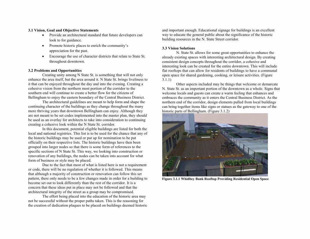
and important enough. Educational signage for buildings is an excellent way to educate the general public about the significance of the historic building resources in the N. State Street corridor. 3.3 Vision Solutions N. State St. allows for some great opportunities to enhance the already existing spaces with interesting architectural design. By creating consistent design concepts throughout the corridor, a cohesive and interesting look can be created for the entire downtown. This will include flat rooftops that can allow for residents of buildings to have a communal open space for shared gardening, cooking, or leisure activities. (Figure 3.1.1) Other aspects included may be things that welcome or demarcate N. State St. as an important portion of the downtown as a whole. Signs that welcome locals and guests can create a warm feeling that enhances and embraces the community as it enters the Central Business District. As the northern end of the corridor, design elements pulled from local buildings can bring together items like signs or statues as the gateway to one of the historic parts of Bellingham. (Figure 3.1.2)
Figure 3.1.1 Whidbey Bank Rooftop Providing Residential Open Space
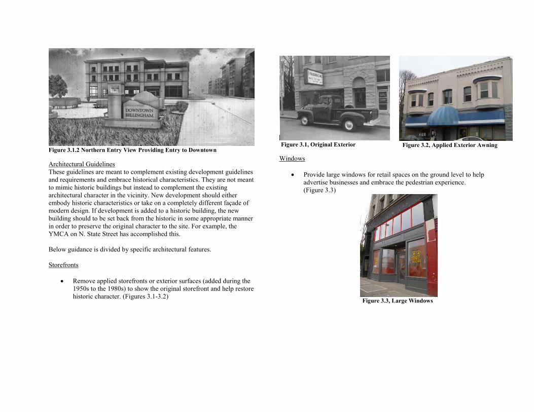
Figure 3.1.2 Northern Entry View Providing Entry to Downtown Architectural Guidelines These guidelines are meant to complement existing development guidelines and requirements and embrace historical characteristics. They are not meant to mimic historic buildings but instead to complement the existing architectural character in the vicinity. New development should either embody historic characteristics or take on a completely different façade of modern design. If development is added to a historic building, the new building should to be set back from the historic in some appropriate manner in order to preserve the original character to the site. For example, the YMCA on N. State Street has accomplished this. Below guidance is divided by specific architectural features. Storefronts
Remove applied storefronts or exterior surfaces (added during the 1950s to the 1980s) to show the original storefront and help restore historic character. (Figures 3.1-3.2)
Figure 3.1, Original Exterior
Windows
Provide large windows for retail spaces on the ground level to help advertise businesses and embrace the pedestrian experience. (Figure 3.3)
Figure 3.3, Large Windows
Figure 3.2, Applied Exterior Awning
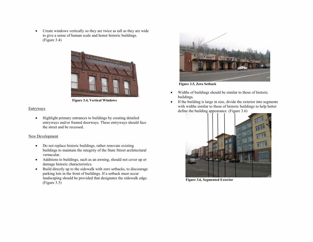
Create windows vertically so they are twice as tall as they are wide to give a sense of human scale and honor historic buildings. (Figure 3.4)
\ Figure 3.4, Vertical Windows
Entryways
Highlight primary entrances to buildings by creating detailed entryways and/or framed doorways. These entryways should face the street and be recessed.
New Development
Do not replace historic buildings, rather renovate existing buildings to maintain the integrity of the State Street architectural vernacular.
Additions to buildings, such as an awning, should not cover up or damage historic characteristics.
Build directly up to the sidewalk with zero setbacks, to discourage parking lots in the front of buildings. If a setback must occur landscaping should be provided that designates the sidewalk edge. (Figure 3.5)
Figure 3.5, Zero Setback
Widths of buildings should be similar to those of historic buildings.
If the building is large in size, divide the exterior into segments with widths similar to those of historic buildings to help better define the building appearance. (Figure 3.6)
Figure 3.6, Segmented Exterior
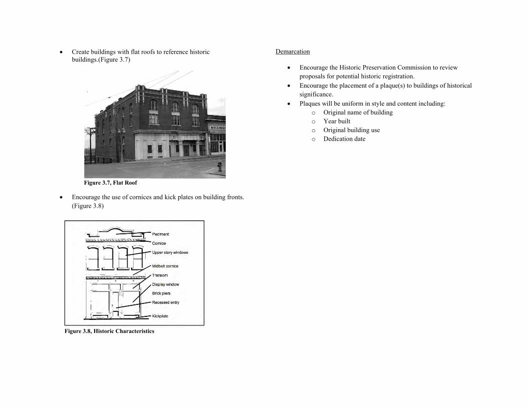
Create buildings with flat roofs to reference historic buildings.(Figure 3.7)
Figure 3.7, Flat Roof
Encourage the use of cornices and kick plates on building fronts. (Figure 3.8)
Figure 3.8, Historic Characteristics
Demarcation
Encourage the Historic Preservation Commission to review proposals for potential historic registration.
Encourage the placement of a plaque(s) to buildings of historical significance.
Plaques will be uniform in style and content including: o Original name of building o Year built o Original building use o Dedication date
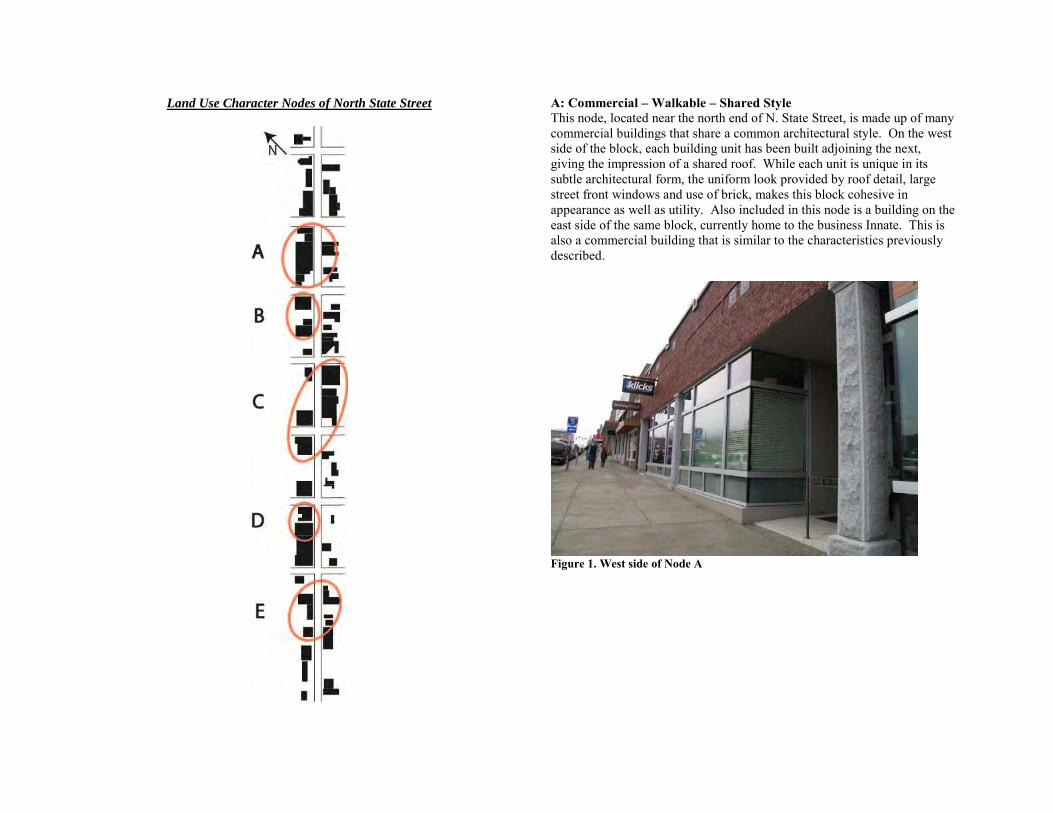
Land Use Character Nodes of North State Street
A: Commercial – Walkable – Shared Style This node, located near the north end of N. State Street, is made up of many commercial buildings that share a common architectural style. On the west side of the block, each building unit has been built adjoining the next, giving the impression of a shared roof. While each unit is unique in its subtle architectural form, the uniform look provided by roof detail, large street front windows and use of brick, makes this block cohesive in appearance as well as utility. Also included in this node is a building on the east side of the same block, currently home to the business Innate. This is also a commercial building that is similar to the characteristics previously described.
Figure 1. West side of Node A
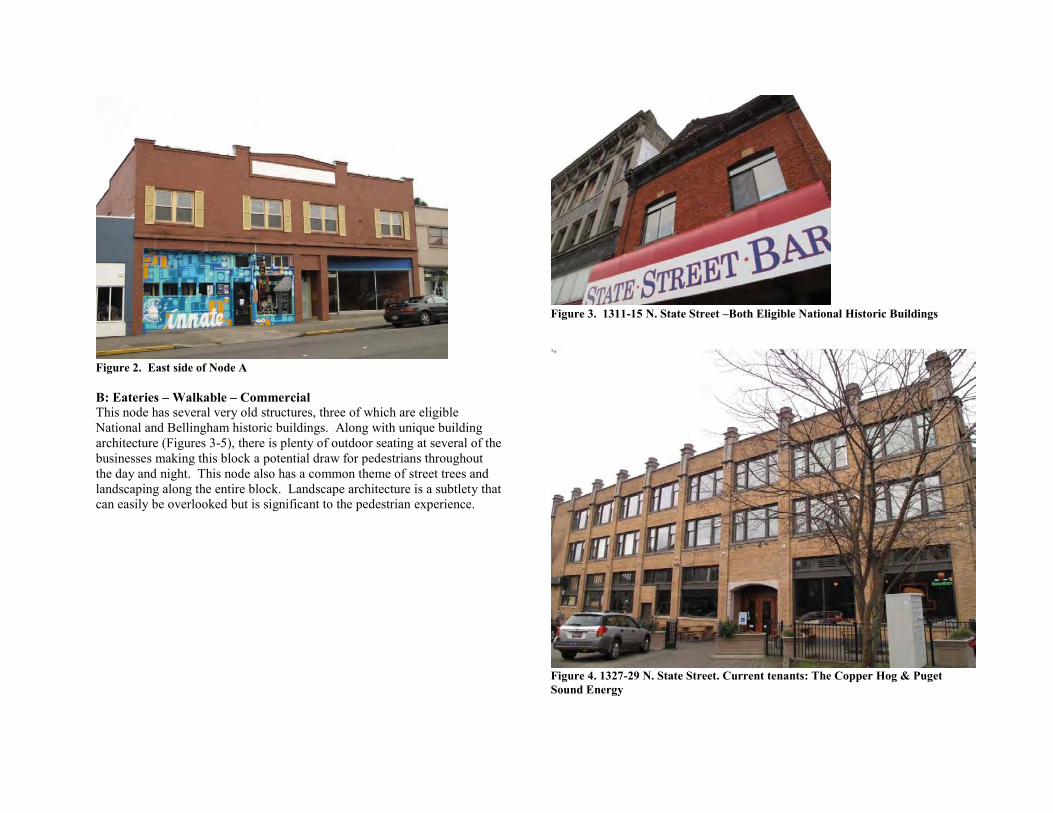
Figure 2. East side of Node A B: Eateries – Walkable – Commercial This node has several very old structures, three of which are eligible National and Bellingham historic buildings. Along with unique building architecture (Figures 3-5), there is plenty of outdoor seating at several of the businesses making this block a potential draw for pedestrians throughout the day and night. This node also has a common theme of street trees and landscaping along the entire block. Landscape architecture is a subtlety that can easily be overlooked but is significant to the pedestrian experience.
Figure 3. 1311-15 N. State Street –Both Eligible National Historic Buildings
Figure 4. 1327-29 N. State Street. Current tenants: The Copper Hog & Puget Sound Energy
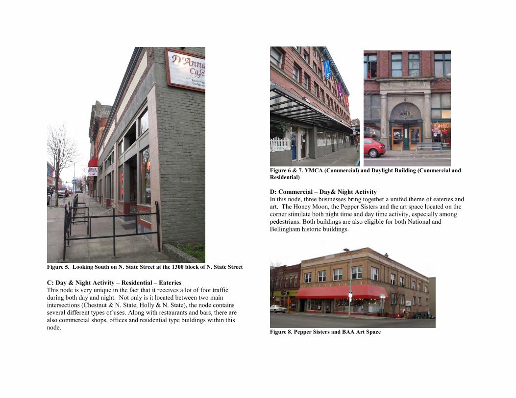
Figure 5. Looking South on N. State Street at the 1300 block of N. State Street C: Day & Night Activity – Residential – Eateries This node is very unique in the fact that it receives a lot of foot traffic during both day and night. Not only is it located between two main intersections (Chestnut & N. State, Holly & N. State), the node contains several different types of uses. Along with restaurants and bars, there are also commercial shops, offices and residential type buildings within this node.
Figure 6 & 7. YMCA (Commercial) and Daylight Building (Commercial and Residential) D: Commercial – Day& Night Activity In this node, three businesses bring together a unifed theme of eateries and art. The Honey Moon, the Pepper Sisters and the art space located on the corner stimilate both night time and day time activity, especially among pedestrians. Both buildings are also eligible for both National and Bellingham historic buildings.
Figure 8. Pepper Sisters and BAA Art Space
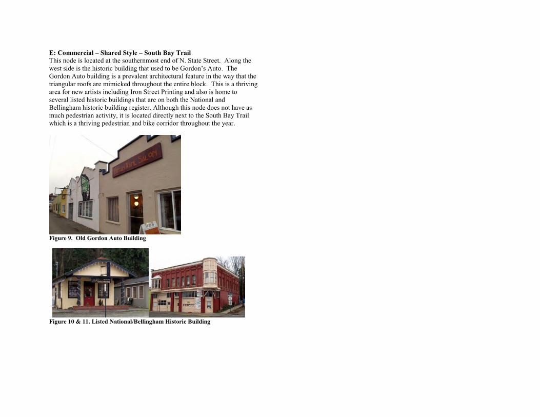
E: Commercial – Shared Style – South Bay Trail This node is located at the southernmost end of N. State Street. Along the west side is the historic building that used to be Gordon’s Auto. The Gordon Auto building is a prevalent architectural feature in the way that the triangular roofs are mimicked throughout the entire block. This is a thriving area for new artists including Iron Street Printing and also is home to several listed historic buildings that are on both the National and Bellingham historic building register. Although this node does not have as much pedestrian activity, it is located directly next to the South Bay Trail which is a thriving pedestrian and bike corridor throughout the year.
Figure 9. Old Gordon Auto Building
Figure 10 & 11. Listed National/Bellingham Historic Building
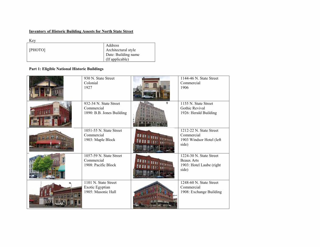
Inventory of Historic Building Assests for North State Street Key [PHOTO]
Address Architectural style Date: Building name (If applicable)
Part 1: Eligible National Historic Buildings
930 N. State Street Colonial 1927
1144-46 N. State Street Commercial 1906
932-34 N. State Street Commercial 1890: B.B. Jones Building
1155 N. State Street Gothic Revival 1926: Herald Building
1051-55 N. State Street Commercial 1903: Maple Block
1212-22 N. State Street Commercial 1903 Windsor Hotel (left side)
1057-59 N. State Street Commercial 1908: Pacific Block
1224-30 N. State Street Beaux Arts 1903: Hotel Laube (right side)
1101 N. State Street Exotic Egyptian 1905: Masonic Hall
1248-60 N. State Street Commercial 1908: Exchange Building
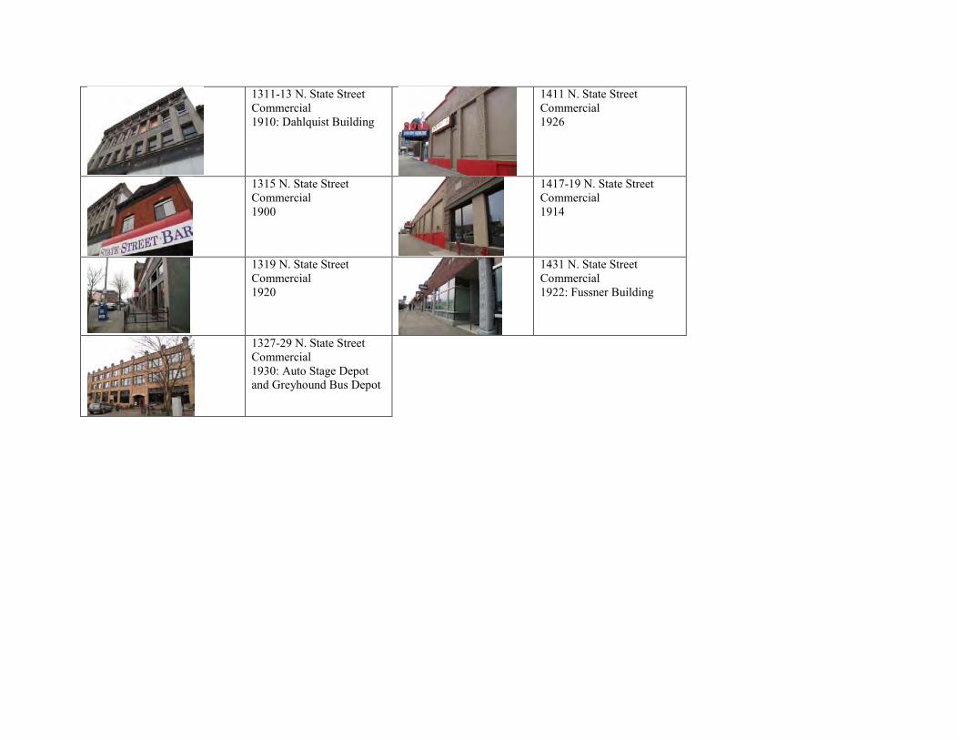
1311-13 N. State Street Commercial 1910: Dahlquist Building
1411 N. State Street Commercial 1926
1315 N. State Street Commercial 1900
1417-19 N. State Street Commercial 1914
1319 N. State Street Commercial 1920
1431 N. State Street Commercial 1922: Fussner Building
1327-29 N. State Street Commercial 1930: Auto Stage Depot and Greyhound Bus Depot
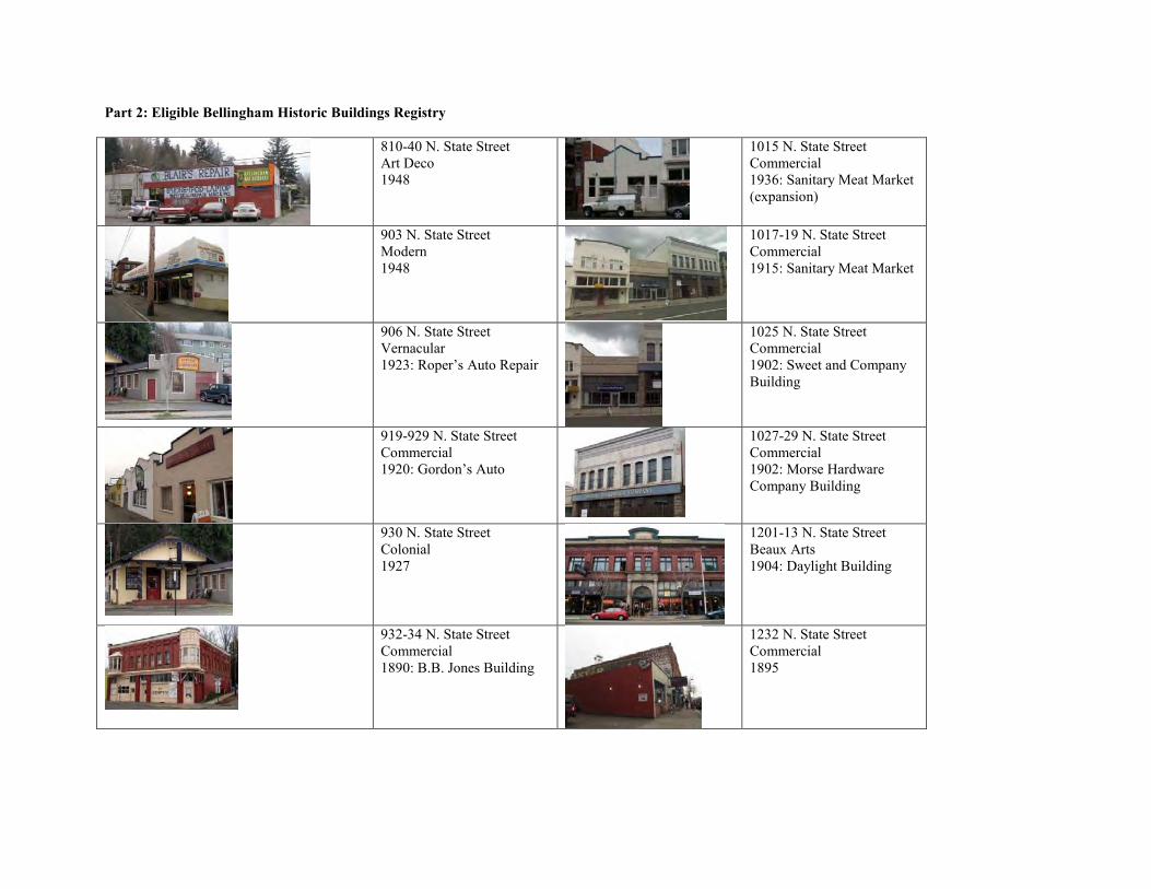
Part 2: Eligible Bellingham Historic Buildings Registry
810-40 N. State Street Art Deco 1948
1015 N. State Street Commercial 1936: Sanitary Meat Market (expansion)
903 N. State Street Modern 1948
1017-19 N. State Street Commercial 1915: Sanitary Meat Market
906 N. State Street Vernacular 1923: Roper’s Auto Repair
1025 N. State Street Commercial 1902: Sweet and Company Building
919-929 N. State Street Commercial 1920: Gordon’s Auto
1027-29 N. State Street Commercial 1902: Morse Hardware Company Building
930 N. State Street Colonial 1927
1201-13 N. State Street Beaux Arts 1904: Daylight Building
932-34 N. State Street Commercial 1890: B.B. Jones Building
1232 N. State Street Commercial 1895
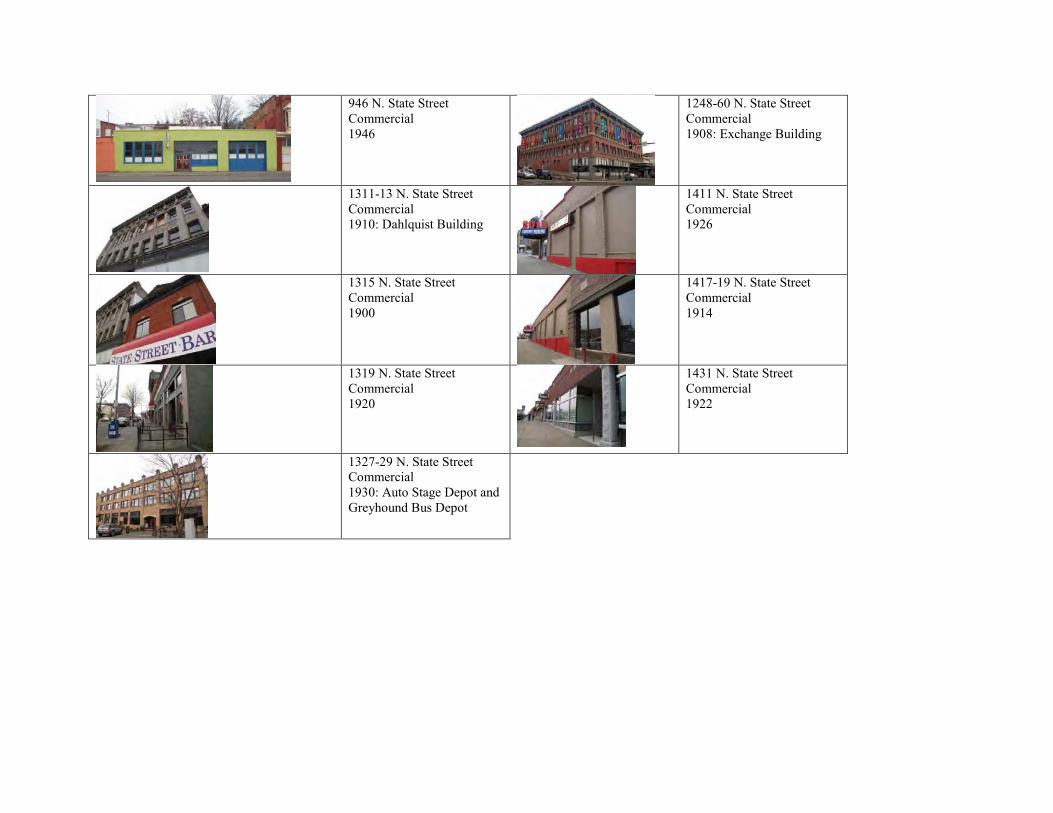
946 N. State Street Commercial 1946
1248-60 N. State Street Commercial 1908: Exchange Building
1311-13 N. State Street Commercial 1910: Dahlquist Building
1411 N. State Street Commercial 1926
1315 N. State Street Commercial 1900
1417-19 N. State Street Commercial 1914
1319 N. State Street Commercial 1920
1431 N. State Street Commercial 1922
1327-29 N. State Street Commercial 1930: Auto Stage Depot and Greyhound Bus Depot
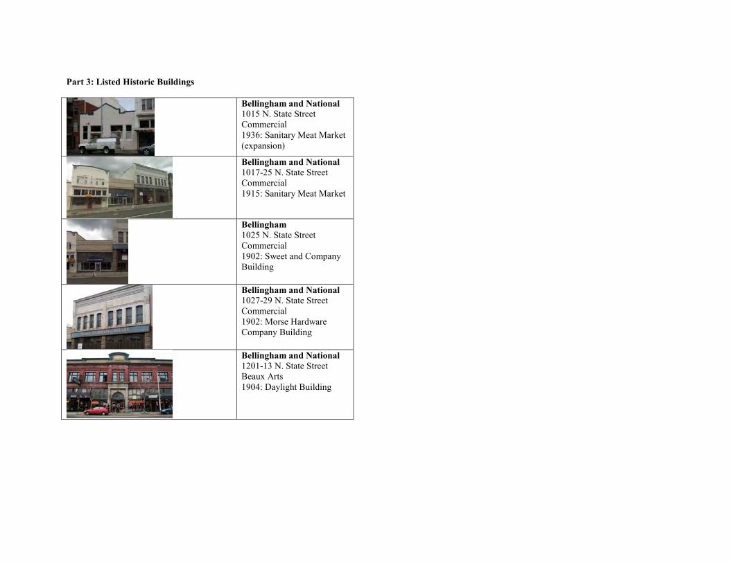
Part 3: Listed Historic Buildings
Bellingham and National 1015 N. State Street Commercial 1936: Sanitary Meat Market (expansion)
Bellingham and National 1017-25 N. State Street Commercial 1915: Sanitary Meat Market
Bellingham 1025 N. State Street Commercial 1902: Sweet and Company Building
Bellingham and National 1027-29 N. State Street Commercial 1902: Morse Hardware Company Building
Bellingham and National 1201-13 N. State Street Beaux Arts 1904: Daylight Building
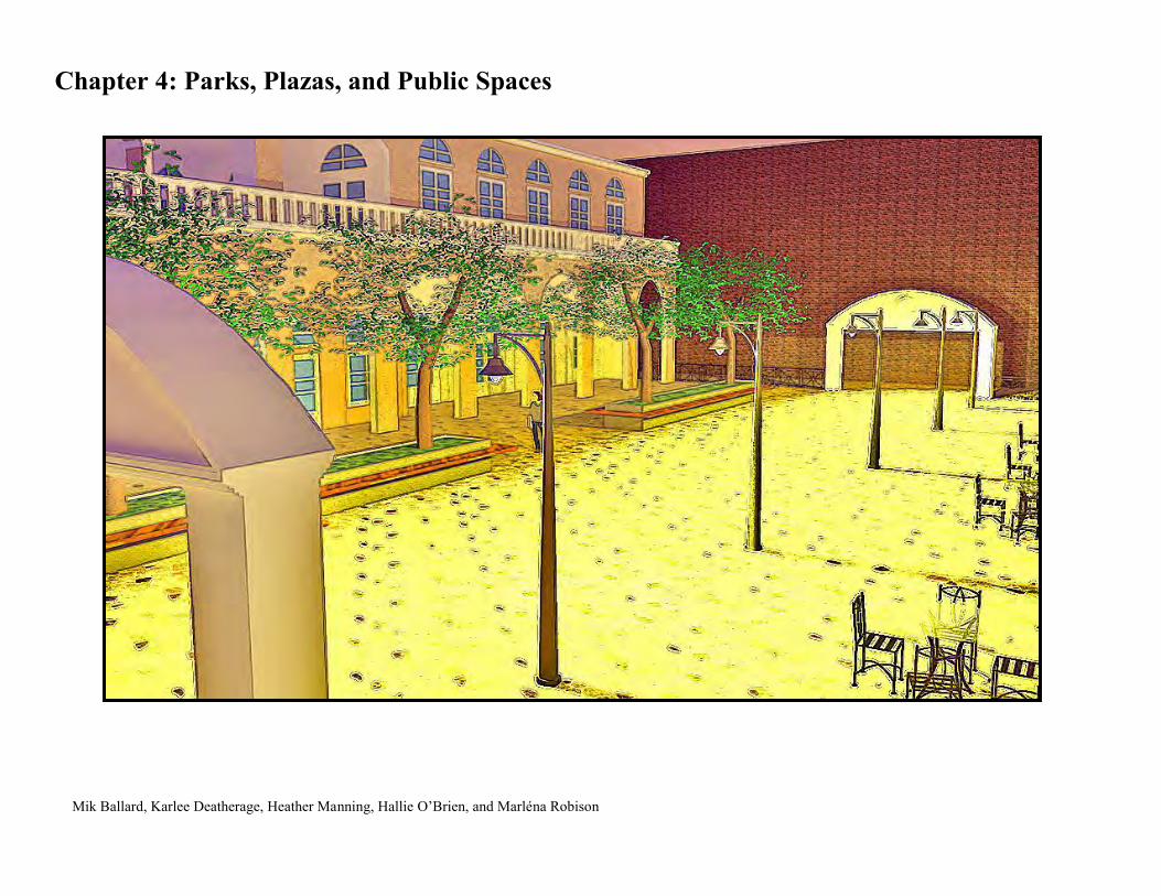
Chapter 4: Parks, Plazas, and Public Spaces
Mik Ballard, Karlee Deatherage, Heather Manning, Hallie O’Brien, and Marléna Robison
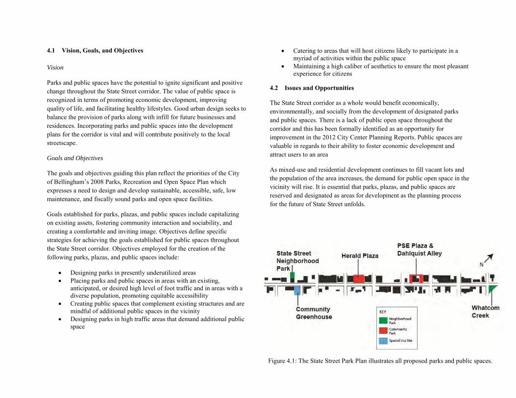
4.1 Vision, Goals, and Objectives Vision
Parks and public spaces have the potential to ignite significant and positive change throughout the State Street corridor. The value of public space is recognized in terms of promoting economic development, improving quality of life, and facilitating healthy lifestyles. Good urban design seeks to balance the provision of parks along with infill for future businesses and residences. Incorporating parks and public spaces into the development plans for the corridor is vital and will contribute positively to the local streetscape.
Goals and Objectives
The goals and objectives guiding this plan reflect the priorities of the City of Bellingham’s 2008 Parks, Recreation and Open Space Plan which expresses a need to design and develop sustainable, accessible, safe, low maintenance, and fiscally sound parks and open space facilities.
Goals established for parks, plazas, and public spaces include capitalizing on existing assets, fostering community interaction and sociability, and creating a comfortable and inviting image. Objectives define specific strategies for achieving the goals established for public spaces throughout the State Street corridor. Objectives employed for the creation of the following parks, plazas, and public spaces include:
Designing parks in presently underutilized areas Placing parks and public spaces in areas with an existing,
anticipated, or desired high level of foot traffic and in areas with a diverse population, promoting equitable accessibility
Creating public spaces that complement existing structures and are mindful of additional public spaces in the vicinity
Designing parks in high traffic areas that demand additional public space
Catering to areas that will host citizens likely to participate in a myriad of activities within the public space
Maintaining a high caliber of aesthetics to ensure the most pleasant experience for citizens
4.2 Issues and Opportunities
The State Street corridor as a whole would benefit economically, environmentally, and socially from the development of designated parks and public spaces. There is a lack of public open space throughout the corridor and this has been formally identified as an opportunity for improvement in the 2012 City Center Planning Reports. Public spaces are valuable in regards to their ability to foster economic development and attract users to an area
As mixed-use and residential development continues to fill vacant lots and the population of the area increases, the demand for public open space in the vicinity will rise. It is essential that parks, plazas, and public spaces are reserved and designated as areas for development as the planning process for the future of State Street unfolds.
Figure 4.1: The State Street Park Plan illustrates all proposed parks and public spaces.
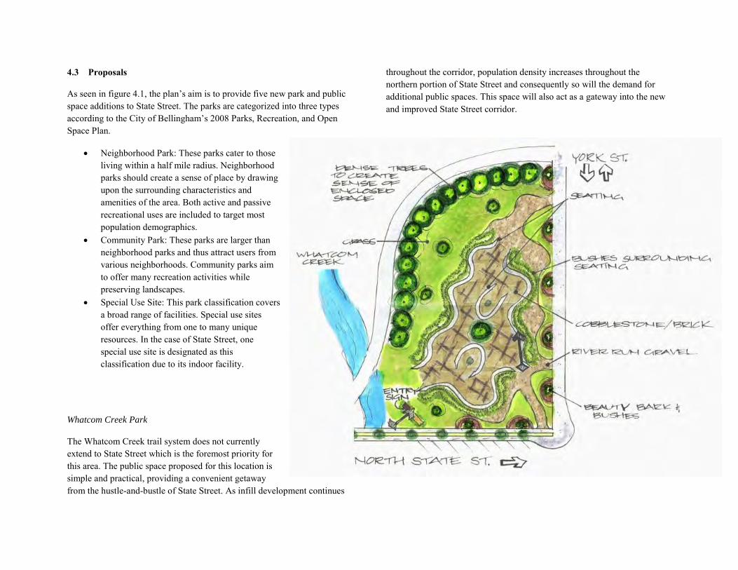
4.3 Proposals
As seen in figure 4.1, the plan’s aim is to provide five new park and public space additions to State Street. The parks are categorized into three types according to the City of Bellingham’s 2008 Parks, Recreation, and Open Space Plan.
Neighborhood Park: These parks cater to those living within a half mile radius. Neighborhood parks should create a sense of place by drawing upon the surrounding characteristics and amenities of the area. Both active and passive recreational uses are included to target most population demographics.
Community Park: These parks are larger than neighborhood parks and thus attract users from various neighborhoods. Community parks aim to offer many recreation activities while preserving landscapes.
Special Use Site: This park classification covers a broad range of facilities. Special use sites offer everything from one to many unique resources. In the case of State Street, one special use site is designated as this classification due to its indoor facility.
Whatcom Creek Park
The Whatcom Creek trail system does not currently extend to State Street which is the foremost priority for this area. The public space proposed for this location is simple and practical, providing a convenient getaway from the hustle-and-bustle of State Street. As infill development continues
throughout the corridor, population density increases throughout the northern portion of State Street and consequently so will the demand for additional public spaces. This space will also act as a gateway into the new and improved State Street corridor.
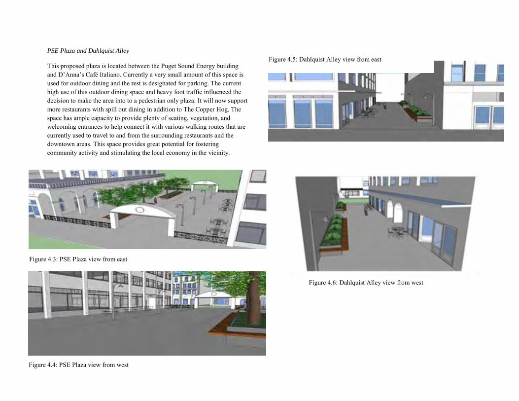
PSE Plaza and Dahlquist Alley
This proposed plaza is located between the Puget Sound Energy building and D’Anna’s Café Italiano. Currently a very small amount of this space is used for outdoor dining and the rest is designated for parking. The current high use of this outdoor dining space and heavy foot traffic influenced the decision to make the area into to a pedestrian only plaza. It will now support more restaurants with spill out dining in addition to The Copper Hog. The space has ample capacity to provide plenty of seating, vegetation, and welcoming entrances to help connect it with various walking routes that are currently used to travel to and from the surrounding restaurants and the downtown areas. This space provides great potential for fostering community activity and stimulating the local economy in the vicinity.
Figure 4.2: An illustration of the proposed gateway park located by Whatcom Creek at the north end of State Street
Figure 4.3: PSE Plaza view from east
Figure 4.4: PSE Plaza view from west
Figure 4.5: Dahlquist Alley view from east
Figure 4.6: Dahlquist Alley view from west
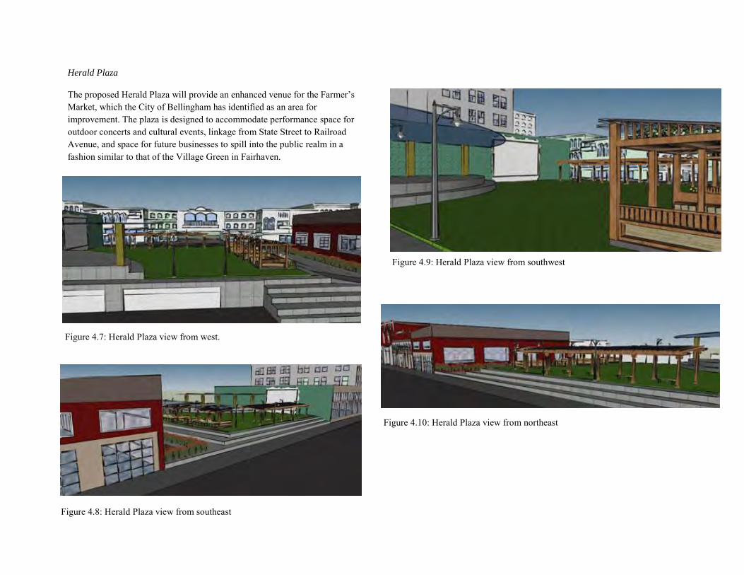
Herald Plaza
The proposed Herald Plaza will provide an enhanced venue for the Farmer’s Market, which the City of Bellingham has identified as an area for improvement. The plaza is designed to accommodate performance space for outdoor concerts and cultural events, linkage from State Street to Railroad Avenue, and space for future businesses to spill into the public realm in a fashion similar to that of the Village Green in Fairhaven.
Figure 4.7: Herald Plaza view from west.
Figure 4.8: Herald Plaza view from southeast
Figure 4.9: Herald Plaza view from southwest
Figure 4.10: Herald Plaza view from northeast
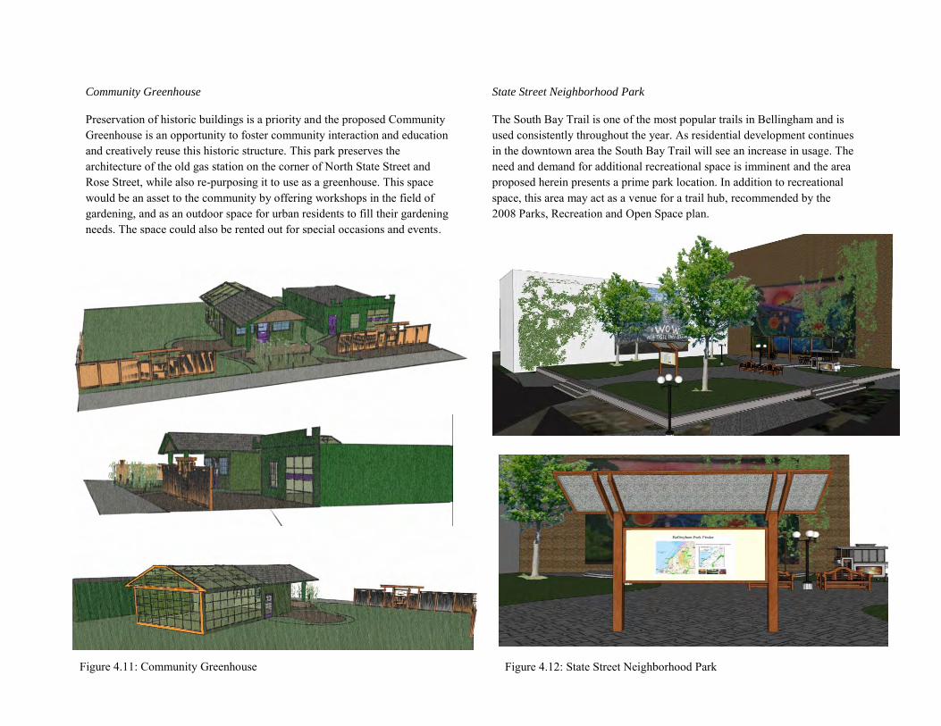
Community Greenhouse
Preservation of historic buildings is a priority and the proposed Community Greenhouse is an opportunity to foster community interaction and education and creatively reuse this historic structure. This park preserves the architecture of the old gas station on the corner of North State Street and Rose Street, while also re-purposing it to use as a greenhouse. This space would be an asset to the community by offering workshops in the field of gardening, and as an outdoor space for urban residents to fill their gardening needs. The space could also be rented out for special occasions and events.
State Street Neighborhood Park
The South Bay Trail is one of the most popular trails in Bellingham and is used consistently throughout the year. As residential development continues in the downtown area the South Bay Trail will see an increase in usage. The need and demand for additional recreational space is imminent and the area proposed herein presents a prime park location. In addition to recreational space, this area may act as a venue for a trail hub, recommended by the 2008 Parks, Recreation and Open Space plan.
Figure 4.11: Community Greenhouse Figure 4.12: State Street Neighborhood Park
Chapter 5.0: Street Design, Vehicular, Transit, and Parking
Katherine McDanold Nick Bruno
Alyssa Ryan Gabe Kincaid
Table of Contents
5.1 Vision, Goals and Objectives Statement 5.2 Issues and Opportunities 5.3 Core Vision Design & Principles 5.3.1 Street Design & Vehicular Transportation Option One: Two-way Bike Lane
Option Two: One-way Bike Lane
5.3.2 Transit 5.3.3 Parking
Parking Policy
Private Parking
Public Parking
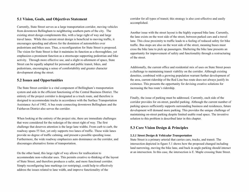
5.1 Vision, Goals, and Objectives Statement
Currently, State Street serves as a large transportation corridor, moving vehicles from downtown Bellingham to neighboring southern parts of the city. The existing street design complements this, with a large right of way and large travel lanes. While this current street design is beneficial to moving traffic, it encourages speeding and allows for the dominion of automobiles over pedestrians and bikes uses. Thus, a reconfiguration for State Street is proposed. The vision for State Street is that it maintains its function as a thoroughfare, yet emphasizes a prominent function as a streetscape supporting pedestrian and bike activity. Through more effective use, and a slight re-allotment of space, State Street can be equally adapted for personal and public transit, bikes, and pedestrians, encouraging a sense of comfortability and greater character development along the street.
5.2 Issues and Opportunities
The State Street corridor is a vital component of Bellingham’s transportation system and aids in the efficient functioning of the Central Business District. The entirety of the project corridor is designated as a truck route, and therefore is designed to accommodate trucks in accordance with the Surface Transportation Assistance Act of 1982. A bus route connecting downtown Bellingham and the Fairhaven District also serves the corridor. When looking at the entirety of the project site, there are immediate challenges that were considered for the redesign of the street right of way. The first challenge that deserves attention is the large lane widths. From curb to curb, the roadway spans 55 feet, yet only supports two lanes of traffic. These wide lanes provide no degree of traffic calming, and present a possible speeding issue. Furthermore, the wide roadway emphasizes auto dominance on the corridor, and discourages alternative forms of transportation. On the other hand, this large right of way allows for reallocation to accommodate non-vehicular uses. This permits creative re-thinking of the layout of State Street, and therefore produces a safer, and more functional corridor. Simply reconfiguring lane markings (or restriping), could help to effectively address the issues related to lane width, and improve functionality of the
corridor for all types of transit; this strategy is also cost-effective and easily accomplished. Another issue with the street layout is the highly exposed bike lane. Currently, the lane exists on the west side of the street, between parked cars and a travel lane. This close proximity to traffic leads to a feeling of reduced safety for bike traffic. Bus stops are also on the west side of the street, meaning buses must cross the bike lane to pick up passengers. Sheltering the bike lane presents an opportunity for improvement of safety and functionality through a restructuring of the street.
Additionally, the current office and residential mix of uses on State Street poses a challenge to maintaining transit viability on the corridor. Although existing densities, combined with a growing population warrant further development of the area, current ridership of the Red Line bus route does not always justify its existence. This presents the opportunity for devising creative solutions for increasing the bus route’s ridership.
Finally, the issue of parking must be addressed. Currently, each side of the corridor provides for on-street, parallel parking. Although the current number of parking spaces sufficiently supports surrounding business and residences, future development will demand more parking. This provides the unique challenge of maintaining on-street parking despite limited usable road space. The inventive solution to this problem is described later in this chapter. 5.3 Core Vision Design & Principles
5.3.1 Street Design & Vehicular Transportation
State Street is a primary arterial that carries cars, trucks, and transit. The intersection depicted in figure 5.1 shows how the proposed changed including land narrowing, moving the bike lane, and back in angle parking should interact at an intersection. In this case, the intersection is E. Maple crossing State Street.
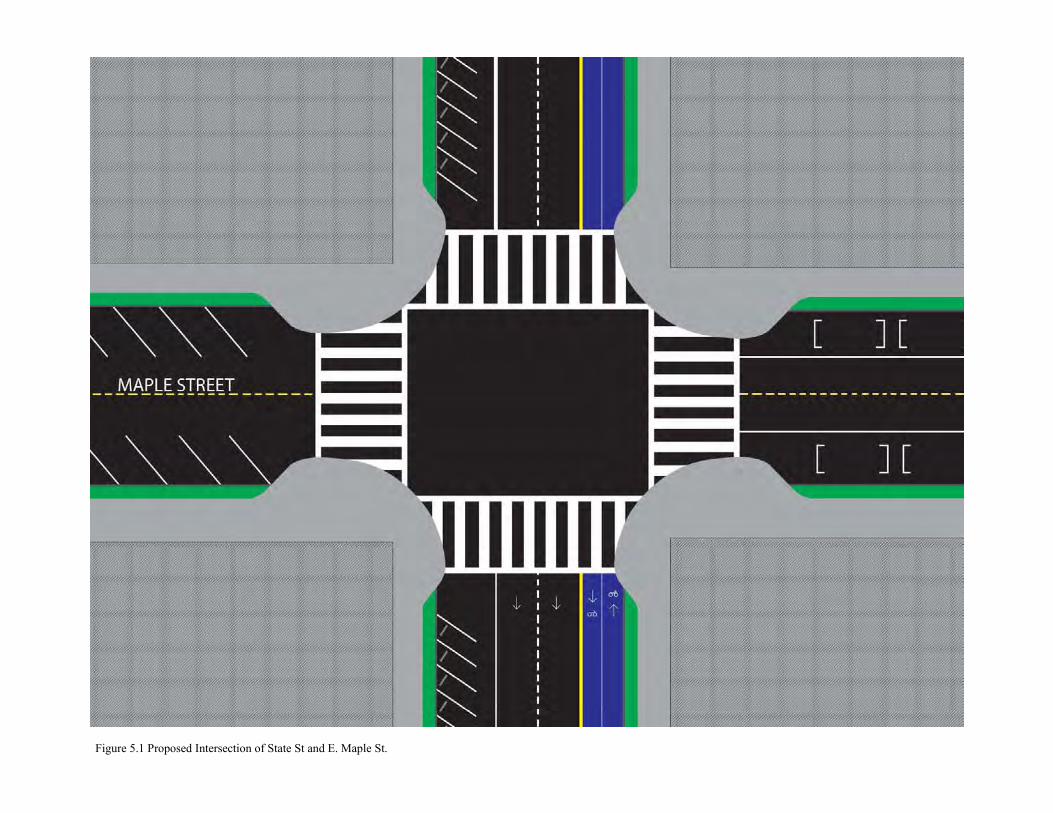
Figure 5.1 Proposed Intersection of State St and E. Maple St.
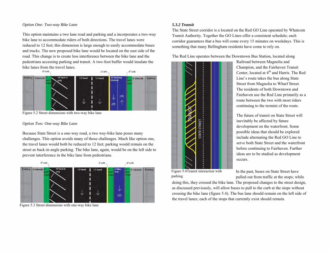
Option One: Two-way Bike Lane
This option maintains a two lane road and parking and a incorporates a two-way bike lane to accommodate riders of both directions. The travel lanes were reduced to 12 feet; this dimension is large enough to easily accommodate buses and trucks. The new proposed bike lane would be located on the east side of the road. This change is to create less interference between the bike lane and the pedestrians accessing parking and transit. A two-foot buffer would insulate the bike lanes from the travel lanes.
Figure 5.2 Street dimensions with two-way bike lane
Option Two: One-way Bike Lane
Because State Street is a one-way road, a two way-bike lane poses many challenges. This option avoids many of those challenges. Much like option one, the travel lanes would both be reduced to 12 feet; parking would remain on the street as back-in angle parking. The bike lane, again, would be on the left side to prevent interference in the bike lane from pedestrians.
5.3.2 Transit
The State Street corridor is a located on the Red GO Line operated by Whatcom Transit Authority. Together the GO Lines offer a consistent schedule; each corridor guarantees that a bus will come every 15 minutes on weekdays. This is something that many Bellingham residents have come to rely on.
The Red Line operates between the Downtown Bus Station, located along Railroad between Magnolia and Champion, and the Fairhaven Transit Center, located at 4th and Harris. The Red Line’s route takes the bus along State Street from Magnolia to Wharf Street. The residents of both Downtown and Fairhaven use the Red Line primarily as a route between the two with most riders continuing to the termini of the route.
The future of transit on State Street will inevitably be affected by future development on the waterfront. Some possible ideas that should be explored include alternating the Red GO Line to serve both State Street and the waterfront before continuing to Fairhaven. Further ideas are to be studied as development occurs.
In the past, buses on State Street have pulled out from traffic at the stops; while
doing this, they crossed the bike lane. The proposed changes to the street design, as discussed previously, will allow buses to pull to the curb at the stops without crossing the bike lane (figure 5.4). The bus lane should remain on the left side of the travel lanes; each of the stops that currently exist should remain.
Figure 5.3 Street dimensions with one-way bike lane
Figure 5.4Transit interaction with parking
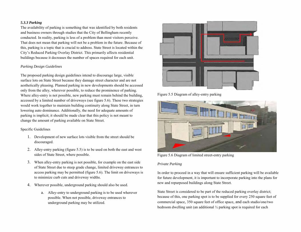
5.3.3 Parking
The availability of parking is something that was identified by both residents and business owners through studies that the City of Bellingham recently conducted. In reality, parking is less of a problem than most visitors perceive. That does not mean that parking will not be a problem in the future. Because of this, parking is a topic that is crucial to address. State Street is located within the City’s Reduced Parking Overlay District. This primarily affects residential buildings because it decreases the number of spaces required for each unit.
Parking Design Guidelines
The proposed parking design guidelines intend to discourage large, visible surface lots on State Street because they damage street character and are not aesthetically pleasing. Planned parking in new developments should be accessed only from the alley, wherever possible, to reduce the prominence of parking. Where alley-entry is not possible, new parking must remain behind the building, accessed by a limited number of driveways (see figure 5.6). These two strategies would work together to maintain building continuity along State Street, in turn lowering auto dominance. Additionally, the need for adequate amounts of parking is implicit; it should be made clear that this policy is not meant to change the amount of parking available on State Street.
Specific Guidelines
1. Development of new surface lots visible from the street should be discouraged.
2. Alley-entry parking (figure 5.5) is to be used on both the east and west sides of State Street, where possible.
3. When alley-entry parking is not possible, for example on the east side of State Street due to steep grade change, limited driveway entrances to access parking may be permitted (figure 5.6). The limit on driveways is to minimize curb cuts and driveway widths.
4. Wherever possible, underground parking should also be used.
a. Alley-entry to underground parking is to be used wherever possible. When not possible, driveway entrances to underground parking may be utilized.
Figure 5.5 Diagram of alley-entry parking
Figure 5.6 Diagram of limited street-entry parking
Private Parking
In order to proceed in a way that will ensure sufficient parking will be available for future development, it is important to incorporate parking into the plans for new and repurposed buildings along State Street.
State Street is considered to be part of the reduced parking overlay district; because of this, one parking spot is to be supplied for every 250 square feet of commercial space, 350 square feet of office space, and each studio/one/two bedroom dwelling unit (an additional ½ parking spot is required for each
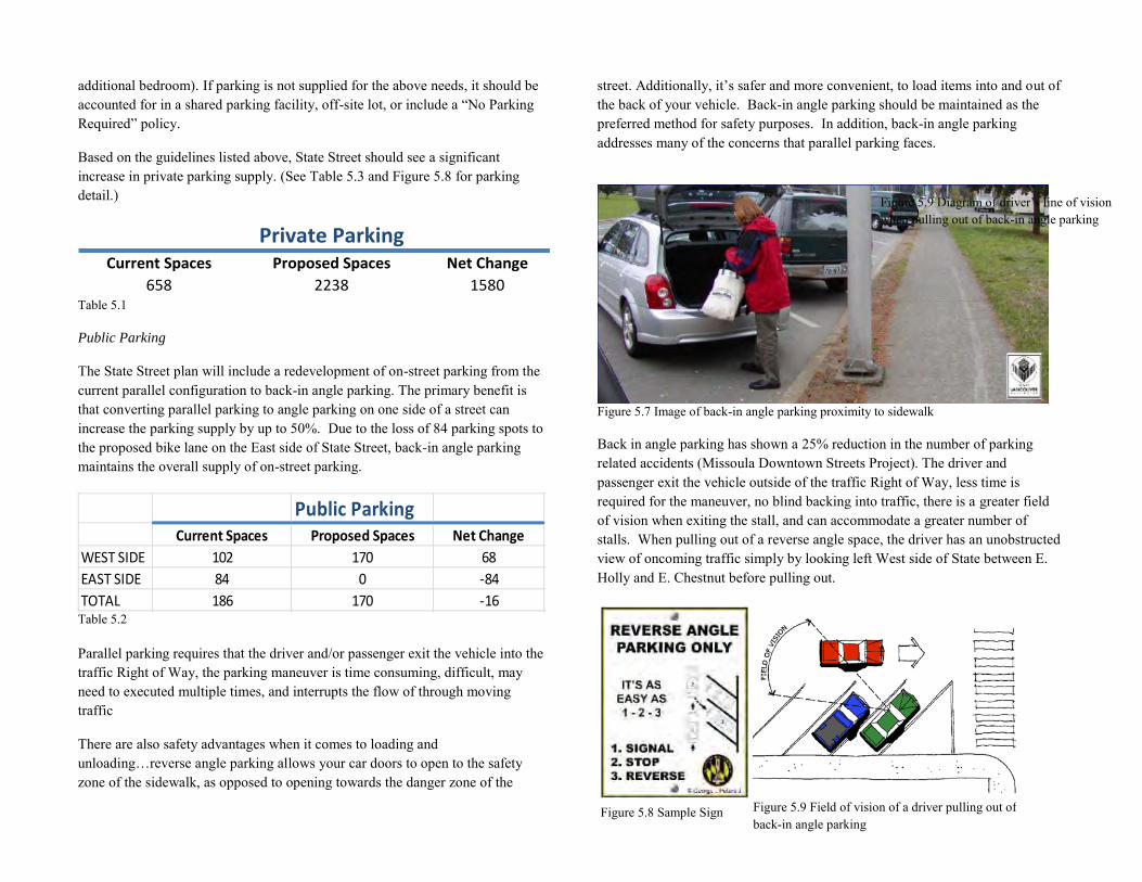
additional bedroom). If parking is not supplied for the above needs, it should be accounted for in a shared parking facility, off-site lot, or include a “No Parking Required” policy.
Based on the guidelines listed above, State Street should see a significant increase in private parking supply. (See Table 5.3 and Figure 5.8 for parking detail.)
Private ParkingCurrent Spaces Proposed Spaces Net Change
658 2238 1580Table 5.1
Public Parking
The State Street plan will include a redevelopment of on-street parking from the current parallel configuration to back-in angle parking. The primary benefit is that converting parallel parking to angle parking on one side of a street can increase the parking supply by up to 50%. Due to the loss of 84 parking spots to the proposed bike lane on the East side of State Street, back-in angle parking maintains the overall supply of on-street parking.
PublicParkingCurrentSpaces ProposedSpaces NetChange
WESTSIDE 102 170 68
EASTSIDE 84 0 -84
TOTAL 186 170 -16 Table 5.2 Parallel parking requires that the driver and/or passenger exit the vehicle into the traffic Right of Way, the parking maneuver is time consuming, difficult, may need to executed multiple times, and interrupts the flow of through moving traffic
There are also safety advantages when it comes to loading and unloading…reverse angle parking allows your car doors to open to the safety zone of the sidewalk, as opposed to opening towards the danger zone of the
street. Additionally, it’s safer and more convenient, to load items into and out of the back of your vehicle. Back-in angle parking should be maintained as the preferred method for safety purposes. In addition, back-in angle parking addresses many of the concerns that parallel parking faces.
Figure 5.7 Image of back-in angle parking proximity to sidewalk
Back in angle parking has shown a 25% reduction in the number of parking related accidents (Missoula Downtown Streets Project). The driver and passenger exit the vehicle outside of the traffic Right of Way, less time is required for the maneuver, no blind backing into traffic, there is a greater field of vision when exiting the stall, and can accommodate a greater number of stalls. When pulling out of a reverse angle space, the driver has an unobstructed view of oncoming traffic simply by looking left West side of State between E. Holly and E. Chestnut before pulling out.
Figure 5.8 Sample Sign
Figure 5.9 Diagram of driver’s line of vision when pulling out of back-in angle parking
Figure 5.9 Field of vision of a driver pulling out of back-in angle parking
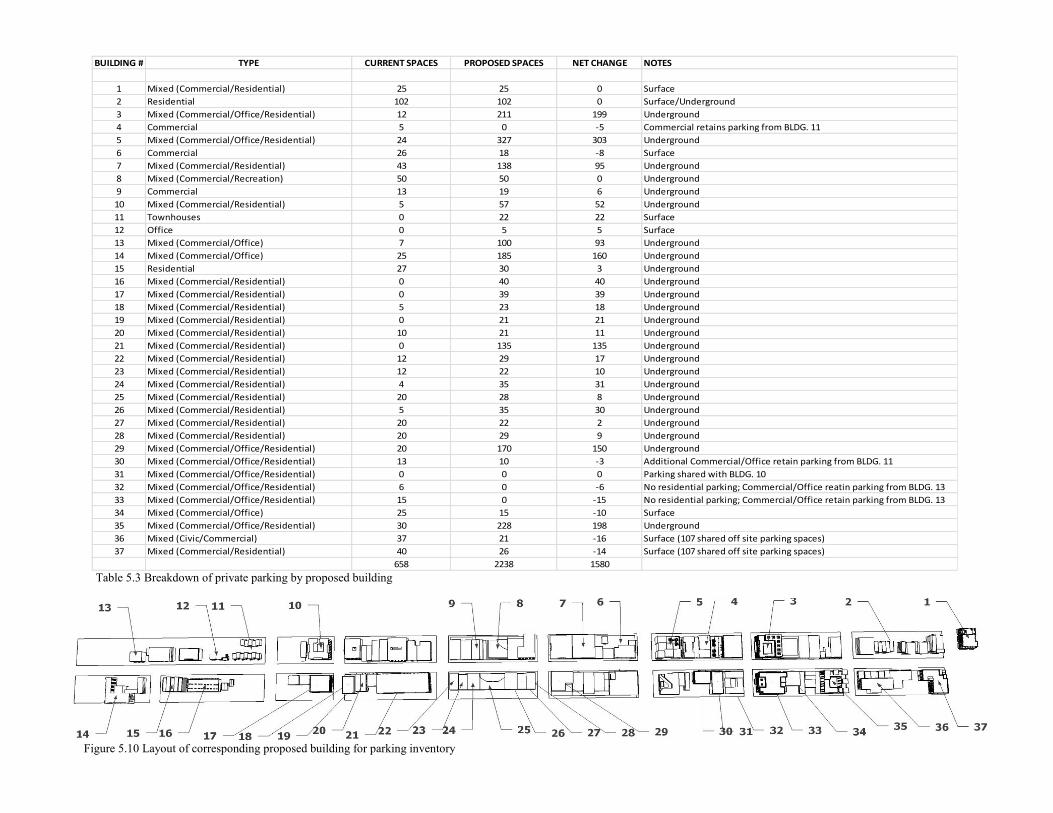
BUILDING # TYPE CURRENT SPACES PROPOSED SPACES NET CHANGE NOTES
1 Mixed (Commercial/Residential) 25 25 0 Surface
2 Residential 102 102 0 Surface/Underground
3 Mixed (Commercial/Office/Residential) 12 211 199 Underground
4 Commercial 5 0 -5 Commercial retains parking from BLDG. 11
5 Mixed (Commercial/Office/Residential) 24 327 303 Underground
6 Commercial 26 18 -8 Surface
7 Mixed (Commercial/Residential) 43 138 95 Underground
8 Mixed (Commercial/Recreation) 50 50 0 Underground
9 Commercial 13 19 6 Underground
10 Mixed (Commercial/Residential) 5 57 52 Underground
11 Townhouses 0 22 22 Surface
12 Office 0 5 5 Surface
13 Mixed (Commercial/Office) 7 100 93 Underground
14 Mixed (Commercial/Office) 25 185 160 Underground
15 Residential 27 30 3 Underground
16 Mixed (Commercial/Residential) 0 40 40 Underground
17 Mixed (Commercial/Residential) 0 39 39 Underground
18 Mixed (Commercial/Residential) 5 23 18 Underground
19 Mixed (Commercial/Residential) 0 21 21 Underground
20 Mixed (Commercial/Residential) 10 21 11 Underground
21 Mixed (Commercial/Residential) 0 135 135 Underground
22 Mixed (Commercial/Residential) 12 29 17 Underground
23 Mixed (Commercial/Residential) 12 22 10 Underground
24 Mixed (Commercial/Residential) 4 35 31 Underground
25 Mixed (Commercial/Residential) 20 28 8 Underground
26 Mixed (Commercial/Residential) 5 35 30 Underground
27 Mixed (Commercial/Residential) 20 22 2 Underground
28 Mixed (Commercial/Residential) 20 29 9 Underground
29 Mixed (Commercial/Office/Residential) 20 170 150 Underground
30 Mixed (Commercial/Office/Residential) 13 10 -3 Additional Commercial/Office retain parking from BLDG. 11
31 Mixed (Commercial/Office/Residential) 0 0 0 Parking shared with BLDG. 10
32 Mixed (Commercial/Office/Residential) 6 0 -6 No residential parking; Commercial/Office reatin parking from BLDG. 13
33 Mixed (Commercial/Office/Residential) 15 0 -15 No residential parking; Commercial/Office retain parking from BLDG. 13
34 Mixed (Commercial/Office) 25 15 -10 Surface
35 Mixed (Commercial/Office/Residential) 30 228 198 Underground
36 Mixed (Civic/Commercial) 37 21 -16 Surface (107 shared off site parking spaces)
37 Mixed (Commercial/Residential) 40 26 -14 Surface (107 shared off site parking spaces)
658 2238 1580
Figure 5.10 Layout of corresponding proposed building for parking inventory
Table 5.3 Breakdown of private parking by proposed building
Chapter 6 Pedestrian and Bicycle Spaces and Connectivity Alyssa Bettinger Megan Lee Alison Ponsen Kiersten Sahlberg
Table of Contents 6.1 Introduction
Vision, Goals and Objectives
6.2 Problems and Opportunities
Trash Cans and Bicycle Racks Alleyways Human-scale Streetlamps and Trees Pedestrian Bulbs Pedestrian Crossings Bike Lane Redesign
6.3 Proposed Solutions
Trash/Recycling Bins and Bike Racks Alleyway Revival Landscaping and Paving
Streetlamps
Mural Programs
Entry Arch
Alley-facing Storefronts
Streetlamps and Trees Pedestrian Bulbs Improved Pedestrian Connections Bike Lane Improvements
Contraflow Bike Lane
One-way Bike Lane
Bicycle Safety
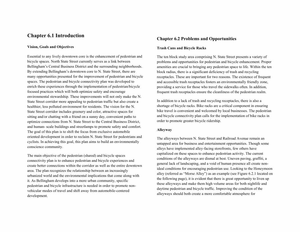
Chapter 6.1 Introduction Vision, Goals and Objectives Essential to any lively downtown core is the enhancement of pedestrian and bicycle spaces. North State Street currently serves as a link between Bellingham’s Central Business District and the surrounding neighborhoods. By extending Bellingham’s downtown core to N. State Street, there are many opportunities presented for the improvement of pedestrian and bicycle spaces. The pedestrian and bicycle connectivity plan was developed to enrich these experiences through the implementation of pedestrian/bicycle focused practices which will both optimize safety and encourage environmental stewardship. These improvements will not only make the N. State Street corridor more appealing to pedestrian traffic but also create a healthier, less polluted environment for residents. The vision for the N. State Street corridor includes greenery and color, attractive spaces for sitting and/or chatting with a friend on a sunny day, convenient paths to optimize connections from N. State Street to the Central Business District, and human- scale buildings and streetlamps to promote safety and comfort. The goal of this plan is to shift the focus from exclusive automobile oriented development in order to reclaim N. State Street for pedestrians and cyclists. In achieving this goal, this plan aims to build an environmentally conscience community.
The main objective of the pedestrian (shared) and bicycle spaces connectivity plan is to enhance pedestrian and bicycle experiences and create better connections within the corridor as well as the entire downtown area. The plan recognizes the relationship between an increasingly urbanized world and the environmental implications that come along with it. As Bellingham develops into a more urban community, specific pedestrian and bicycle infrastructure is needed in order to promote non-vehicular modes of travel and shift away from automobile-centered development.
Chapter 6.2 Problems and Opportunities
Trash Cans and Bicycle Racks
The ten block study area comprising N. State Street presents a variety of problems and opportunities for pedestrian and bicycle enhancement. Proper amenities are crucial to bringing any pedestrian space to life. Within the ten block radius, there is a significant deficiency of trash and recycling receptacles. These are important for two reasons. The existence of frequent and accessible trash receptacles fosters an environmentally friendly zone, providing a service for those who travel the sidewalks often. In addition, frequent trash receptacles ensure the cleanliness of the pedestrian realm.
In addition to a lack of trash and recycling receptacles, there is also a shortage of bicycle racks. Bike racks are a critical component in ensuring bike travel is convenient and welcomed by local businesses. The pedestrian and bicycle connectivity plan calls for the implementation of bike racks in order to promote greater bicycle ridership.
Alleyway
The alleyways between N. State Street and Railroad Avenue remain an untapped area for business and entertainment opportunities. Though some alleys have implemented alley-facing storefronts, few others have capitalized on these spaces to enhance pedestrian activity. The current conditions of the alleyways are dismal at best. Uneven paving, graffiti, a general lack of landscaping, and a void of human presence all create non-ideal conditions for encouraging pedestrian use. Looking to the Honeymoon alley (referred as “Morse Alley”) as an example (see Figure 6.2.1 located on the following page), it is evident that there is great opportunity to liven up these alleyways and make them high volume areas for both nightlife and daytime pedestrian and bicycle traffic. Improving the condition of the alleyways should both create a more comfortable atmosphere for
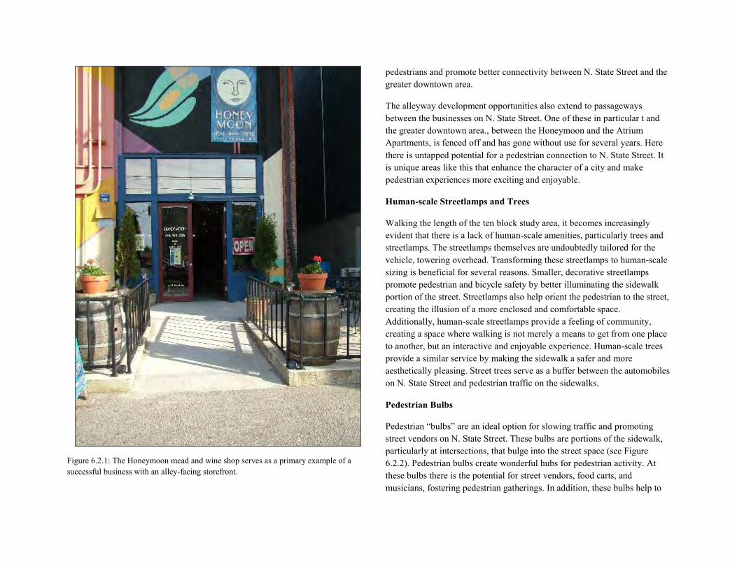
Figure 6.2.1: The Honeymoon mead and wine shop serves as a primary example of a successful business with an alley-facing storefront.
pedestrians and promote better connectivity between N. State Street and the greater downtown area.
The alleyway development opportunities also extend to passageways between the businesses on N. State Street. One of these in particular t and the greater downtown area., between the Honeymoon and the Atrium Apartments, is fenced off and has gone without use for several years. Here there is untapped potential for a pedestrian connection to N. State Street. It is unique areas like this that enhance the character of a city and make pedestrian experiences more exciting and enjoyable.
Human-scale Streetlamps and Trees
Walking the length of the ten block study area, it becomes increasingly evident that there is a lack of human-scale amenities, particularly trees and streetlamps. The streetlamps themselves are undoubtedly tailored for the vehicle, towering overhead. Transforming these streetlamps to human-scale sizing is beneficial for several reasons. Smaller, decorative streetlamps promote pedestrian and bicycle safety by better illuminating the sidewalk portion of the street. Streetlamps also help orient the pedestrian to the street, creating the illusion of a more enclosed and comfortable space. Additionally, human-scale streetlamps provide a feeling of community, creating a space where walking is not merely a means to get from one place to another, but an interactive and enjoyable experience. Human-scale trees provide a similar service by making the sidewalk a safer and more aesthetically pleasing. Street trees serve as a buffer between the automobiles on N. State Street and pedestrian traffic on the sidewalks.
Pedestrian Bulbs
Pedestrian “bulbs” are an ideal option for slowing traffic and promoting street vendors on N. State Street. These bulbs are portions of the sidewalk, particularly at intersections, that bulge into the street space (see Figure 6.2.2). Pedestrian bulbs create wonderful hubs for pedestrian activity. At these bulbs there is the potential for street vendors, food carts, and musicians, fostering pedestrian gatherings. In addition, these bulbs help to
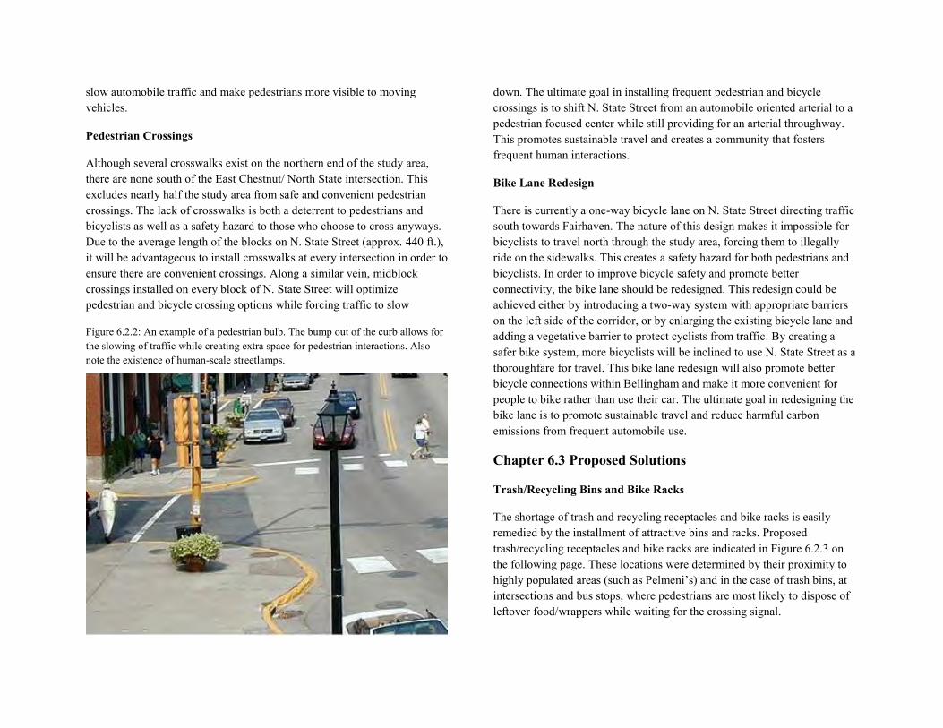
slow automobile traffic and make pedestrians more visible to moving vehicles.
Pedestrian Crossings
Although several crosswalks exist on the northern end of the study area, there are none south of the East Chestnut/ North State intersection. This excludes nearly half the study area from safe and convenient pedestrian crossings. The lack of crosswalks is both a deterrent to pedestrians and bicyclists as well as a safety hazard to those who choose to cross anyways. Due to the average length of the blocks on N. State Street (approx. 440 ft.), it will be advantageous to install crosswalks at every intersection in order to ensure there are convenient crossings. Along a similar vein, midblock crossings installed on every block of N. State Street will optimize pedestrian and bicycle crossing options while forcing traffic to slow
Figure 6.2.2: An example of a pedestrian bulb. The bump out of the curb allows for the slowing of traffic while creating extra space for pedestrian interactions. Also note the existence of human-scale streetlamps.
down. The ultimate goal in installing frequent pedestrian and bicycle crossings is to shift N. State Street from an automobile oriented arterial to a pedestrian focused center while still providing for an arterial throughway. This promotes sustainable travel and creates a community that fosters frequent human interactions.
Bike Lane Redesign
There is currently a one-way bicycle lane on N. State Street directing traffic south towards Fairhaven. The nature of this design makes it impossible for bicyclists to travel north through the study area, forcing them to illegally ride on the sidewalks. This creates a safety hazard for both pedestrians and bicyclists. In order to improve bicycle safety and promote better connectivity, the bike lane should be redesigned. This redesign could be achieved either by introducing a two-way system with appropriate barriers on the left side of the corridor, or by enlarging the existing bicycle lane and adding a vegetative barrier to protect cyclists from traffic. By creating a safer bike system, more bicyclists will be inclined to use N. State Street as a thoroughfare for travel. This bike lane redesign will also promote better bicycle connections within Bellingham and make it more convenient for people to bike rather than use their car. The ultimate goal in redesigning the bike lane is to promote sustainable travel and reduce harmful carbon emissions from frequent automobile use.
Chapter 6.3 Proposed Solutions
Trash/Recycling Bins and Bike Racks
The shortage of trash and recycling receptacles and bike racks is easily remedied by the installment of attractive bins and racks. Proposed trash/recycling receptacles and bike racks are indicated in Figure 6.2.3 on the following page. These locations were determined by their proximity to highly populated areas (such as Pelmeni’s) and in the case of trash bins, at intersections and bus stops, where pedestrians are most likely to dispose of leftover food/wrappers while waiting for the crossing signal.
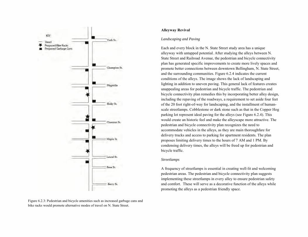
Figure 6.2.3: Pedestrian and bicycle amenities such as increased garbage cans and bike racks would promote alternative modes of travel on N. State Street.
Alleyway Revival
Landscaping and Paving
Each and every block in the N. State Street study area has a unique alleyway with untapped potential. After studying the alleys between N. State Street and Railroad Avenue, the pedestrian and bicycle connectivity plan has generated specific improvements to create more lively spaces and promote better connections between downtown Bellingham, N. State Street, and the surrounding communities. Figure 6.2.4 indicates the current conditions of the alleys. The image shows the lack of landscaping and lighting in addition to uneven paving. This general lack of features creates unappealing areas for pedestrian and bicycle traffic. The pedestrian and bicycle connectivity plan remedies this by incorporating better alley design, including the repaving of the roadways, a requirement to set aside four feet of the 20 foot right-of-way for landscaping, and the installment of human-scale streetlamps. Cobblestone or dark stone such as that in the Copper Hog parking lot represent ideal paving for the alleys (see Figure 6.2.4). This would create an historic feel and make the alleyscape more attractive. The pedestrian and bicycle connectivity plan recognizes the need to accommodate vehicles in the alleys, as they are main thoroughfare for delivery trucks and access to parking for apartment residents. The plan proposes limiting delivery times to the hours of 7 AM and 1 PM. By condensing delivery times, the alleys will be freed up for pedestrian and bicycle traffic.
Streetlamps
A frequency of streetlamps is essential in creating well-lit and welcoming pedestrian areas. The pedestrian and bicycle connectivity plan suggests implementing these streetlamps in every alley to ensure pedestrian safety and comfort. These will serve as a decorative function of the alleys while promoting the alleys as a pedestrian friendly space.
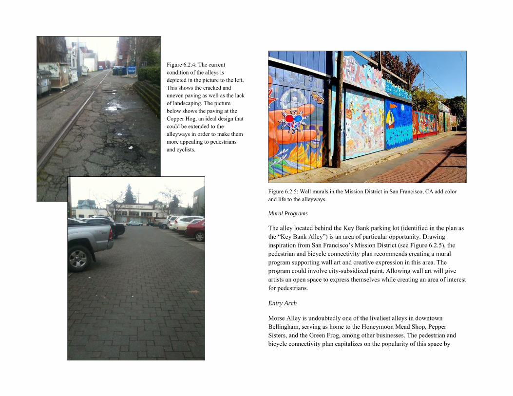
Figure 6.2.4: The current condition of the alleys is depicted in the picture to the left. This shows the cracked and uneven paving as well as the lack of landscaping. The picture below shows the paving at the Copper Hog, an ideal design that could be extended to the alleyways in order to make them more appealing to pedestrians and cyclists.
Figure 6.2.5: Wall murals in the Mission District in San Francisco, CA add color and life to the alleyways.
Mural Programs
The alley located behind the Key Bank parking lot (identified in the plan as the “Key Bank Alley”) is an area of particular opportunity. Drawing inspiration from San Francisco’s Mission District (see Figure 6.2.5), the pedestrian and bicycle connectivity plan recommends creating a mural program supporting wall art and creative expression in this area. The program could involve city-subsidized paint. Allowing wall art will give artists an open space to express themselves while creating an area of interest for pedestrians.
Entry Arch
Morse Alley is undoubtedly one of the liveliest alleys in downtown Bellingham, serving as home to the Honeymoon Mead Shop, Pepper Sisters, and the Green Frog, among other businesses. The pedestrian and bicycle connectivity plan capitalizes on the popularity of this space by
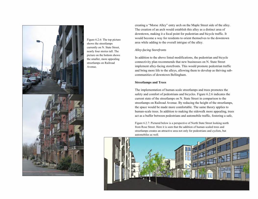
Figure 6.2.6: The top picture shows the streetlamps currently on N. State Street, nearly four stories tall. The picture on the bottom shows the smaller, more appealing streetlamps on Railroad Avenue.
creating a “Morse Alley” entry arch on the Maple Street side of the alley. The creation of an arch would establish this alley as a distinct area of downtown, making it a focal point for pedestrian and bicycle traffic. It would become a way for residents to orient themselves to the downtown area while adding to the overall intrigue of the alley.
Alley-facing Storefronts
In addition to the above listed modifications, the pedestrian and bicycle connectivity plan recommends that new businesses on N. State Street implement alley-facing storefronts. This would promote pedestrian traffic and bring more life to the alleys, allowing them to develop as thriving sub-communities of downtown Bellingham.
Streetlamps and Trees
The implementation of human-scale streetlamps and trees promotes the safety and comfort of pedestrians and bicycles. Figure 6.2.6 indicates the current state of the streetlamps on N. State Street in comparison to the streetlamps on Railroad Avenue. By reducing the height of the streetlamps, the space would be made more comfortable. The same theory applies to human-scale trees. In addition to making the sidewalk more appealing, trees act as a buffer between pedestrians and automobile traffic, fostering a safe,
Figure 6.2.7: Pictured below is a perspective of North State Street looking north from Rose Street. Here it is seen that the addition of human-scaled trees and streetlamps creates an attractive area not only for pedestrians and cyclists, but automobiles as well.
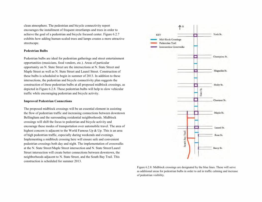
clean atmosphere. The pedestrian and bicycle connectivity report encourages the installment of frequent streetlamps and trees in order to achieve the goal of a pedestrian and bicycle focused center. Figure 6.2.7 exhibits how adding human-scaled trees and lamps creates a more attractive streetscape.
Pedestrian Bulbs
Pedestrian bulbs are ideal for pedestrian gatherings and street entertainment opportunities (musicians, food vendors, etc.). Areas of particular opportunity on N. State Street are the intersections at N. State Street and Maple Street as well as N. State Street and Laurel Street. Construction of these bulbs is scheduled to begin in summer of 2013. In addition to these intersections, the pedestrian and bicycle connectivity plan suggests the construction of these pedestrian bulbs at all proposed midblock crossings, as depicted in Figure 6.2.8. These pedestrian bulbs will help to slow vehicular traffic while encouraging pedestrian and bicycle activity.
Improved Pedestrian Connections
The proposed midblock crossings will be an essential element in assisting the flow of pedestrian traffic and increasing connections between downtown Bellingham and the surrounding residential neighborhoods. Midblock crossings will shift the focus to pedestrian and bicycle activity and encourage these modes of transportation over automobile travel. The area of highest concern is adjacent to the World Famous Up & Up. This is an area of high pedestrian traffic, especially during weekends and evenings. Implementing a midblock crossing here will ensure safe and convenient pedestrian crossings both day and night. The implementation of crosswalks at the N. State Street/Maple Street intersection and N. State Street/Laurel Street intersection will create better connections between downtown, the neighborhoods adjacent to N. State Street, and the South Bay Trail. This construction is scheduled for summer 2013.
Figure 6.2.8: Midblock crossings are designated by the blue lines. These will serve as additional areas for pedestrian bulbs in order to aid in traffic calming and increase of pedestrian visibility.
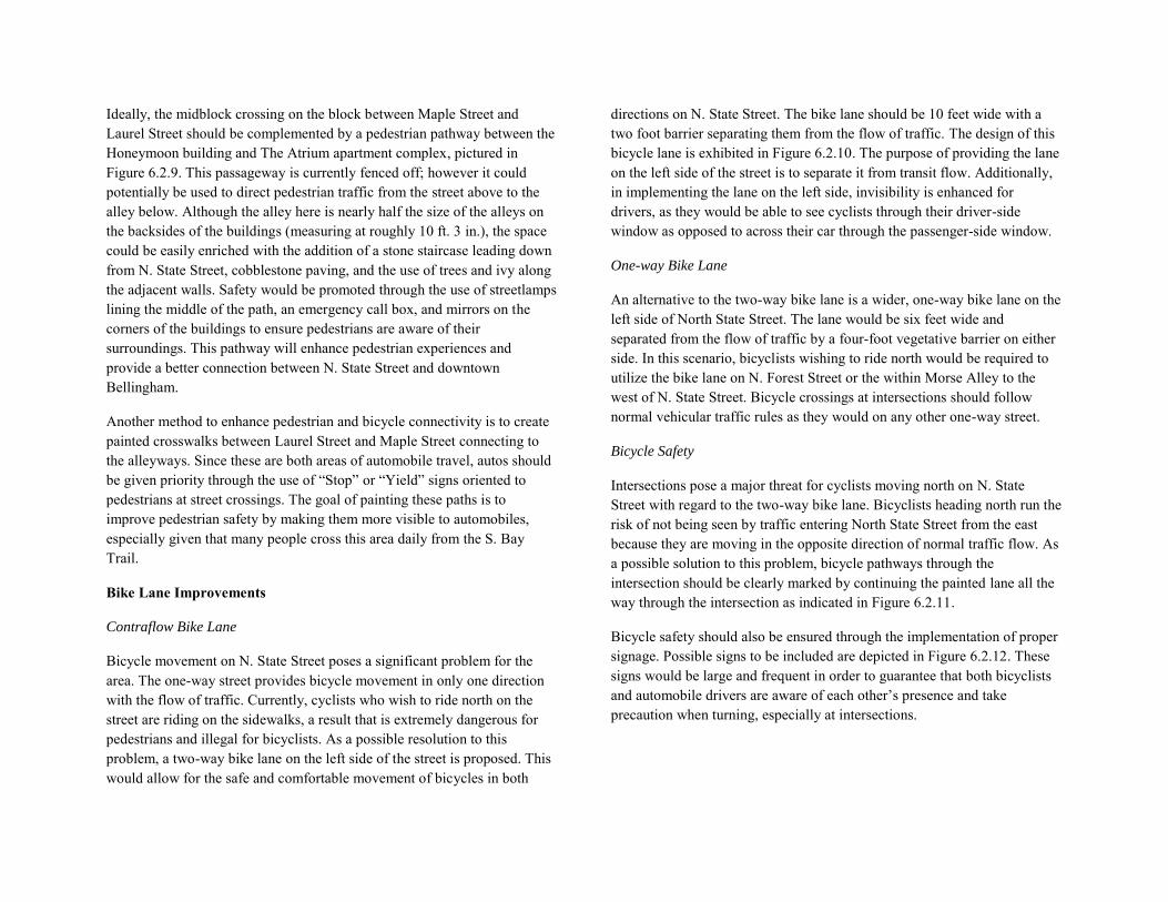
Ideally, the midblock crossing on the block between Maple Street and Laurel Street should be complemented by a pedestrian pathway between the Honeymoon building and The Atrium apartment complex, pictured in Figure 6.2.9. This passageway is currently fenced off; however it could potentially be used to direct pedestrian traffic from the street above to the alley below. Although the alley here is nearly half the size of the alleys on the backsides of the buildings (measuring at roughly 10 ft. 3 in.), the space could be easily enriched with the addition of a stone staircase leading down from N. State Street, cobblestone paving, and the use of trees and ivy along the adjacent walls. Safety would be promoted through the use of streetlamps lining the middle of the path, an emergency call box, and mirrors on the corners of the buildings to ensure pedestrians are aware of their surroundings. This pathway will enhance pedestrian experiences and provide a better connection between N. State Street and downtown Bellingham.
Another method to enhance pedestrian and bicycle connectivity is to create painted crosswalks between Laurel Street and Maple Street connecting to the alleyways. Since these are both areas of automobile travel, autos should be given priority through the use of “Stop” or “Yield” signs oriented to pedestrians at street crossings. The goal of painting these paths is to improve pedestrian safety by making them more visible to automobiles, especially given that many people cross this area daily from the S. Bay Trail.
Bike Lane Improvements
Contraflow Bike Lane
Bicycle movement on N. State Street poses a significant problem for the area. The one-way street provides bicycle movement in only one direction with the flow of traffic. Currently, cyclists who wish to ride north on the street are riding on the sidewalks, a result that is extremely dangerous for pedestrians and illegal for bicyclists. As a possible resolution to this problem, a two-way bike lane on the left side of the street is proposed. This would allow for the safe and comfortable movement of bicycles in both
directions on N. State Street. The bike lane should be 10 feet wide with a two foot barrier separating them from the flow of traffic. The design of this bicycle lane is exhibited in Figure 6.2.10. The purpose of providing the lane on the left side of the street is to separate it from transit flow. Additionally, in implementing the lane on the left side, invisibility is enhanced for drivers, as they would be able to see cyclists through their driver-side window as opposed to across their car through the passenger-side window.
One-way Bike Lane
An alternative to the two-way bike lane is a wider, one-way bike lane on the left side of North State Street. The lane would be six feet wide and separated from the flow of traffic by a four-foot vegetative barrier on either side. In this scenario, bicyclists wishing to ride north would be required to utilize the bike lane on N. Forest Street or the within Morse Alley to the west of N. State Street. Bicycle crossings at intersections should follow normal vehicular traffic rules as they would on any other one-way street.
Bicycle Safety
Intersections pose a major threat for cyclists moving north on N. State Street with regard to the two-way bike lane. Bicyclists heading north run the risk of not being seen by traffic entering North State Street from the east because they are moving in the opposite direction of normal traffic flow. As a possible solution to this problem, bicycle pathways through the intersection should be clearly marked by continuing the painted lane all the way through the intersection as indicated in Figure 6.2.11.
Bicycle safety should also be ensured through the implementation of proper signage. Possible signs to be included are depicted in Figure 6.2.12. These signs would be large and frequent in order to guarantee that both bicyclists and automobile drivers are aware of each other’s presence and take precaution when turning, especially at intersections.
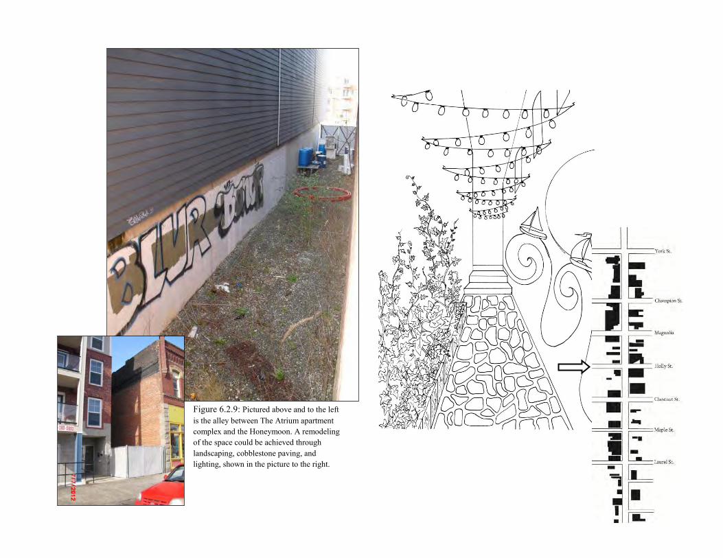
Figure 6.2.9: Pictured above and to the left is the alley between The Atrium apartment complex and the Honeymoon. A remodeling of the space could be achieved through landscaping, cobblestone paving, and lighting, shown in the picture to the right.
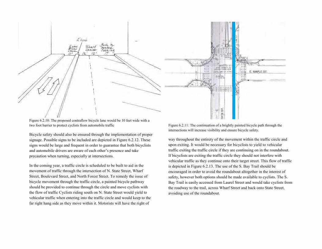
Figure 6.2.10: The proposed contraflow bicycle lane would be 10 feet wide with a two foot barrier to protect cyclists from automobile traffic
Bicycle safety should also be ensured through the implementation of proper signage. Possible signs to be included are depicted in Figure 6.2.12. These signs would be large and frequent in order to guarantee that both bicyclists and automobile drivers are aware of each other’s presence and take precaution when turning, especially at intersections.
In the coming year, a traffic circle is scheduled to be built to aid in the movement of traffic through the intersection of N. State Street, Wharf Street, Boulevard Street, and North Forest Street. To remedy the issue of bicycle movement through the traffic circle, a painted bicycle pathway should be provided to continue through the circle and move cyclists with the flow of traffic Cyclists riding south on N. State Street would yield to vehicular traffic when entering into the traffic circle and would keep to the far right hang side as they move within it. Motorists will have the right of
Figure 6.2.11: The continuation of a brightly painted bicycle path through the intersections will increase visibility and ensure bicycle safety.
way throughout the entirety of the movement within the traffic circle and upon exiting. It would be necessary for bicyclists to yield to vehicular traffic exiting the traffic circle if they are continuing on in the roundabout. If bicyclists are exiting the traffic circle they should not interfere with vehicular traffic as they continue onto their target street. This flow of traffic is depicted in Figure 6.2.13. The use of the S. Bay Trail should be encouraged in order to avoid the roundabout altogether in the interest of safety, however both options should be made available to cyclists. The S. Bay Trail is easily accessed from Laurel Street and would take cyclists from the roadway to the trail, across Wharf Street and back onto State Street, avoiding use of the roundabout.
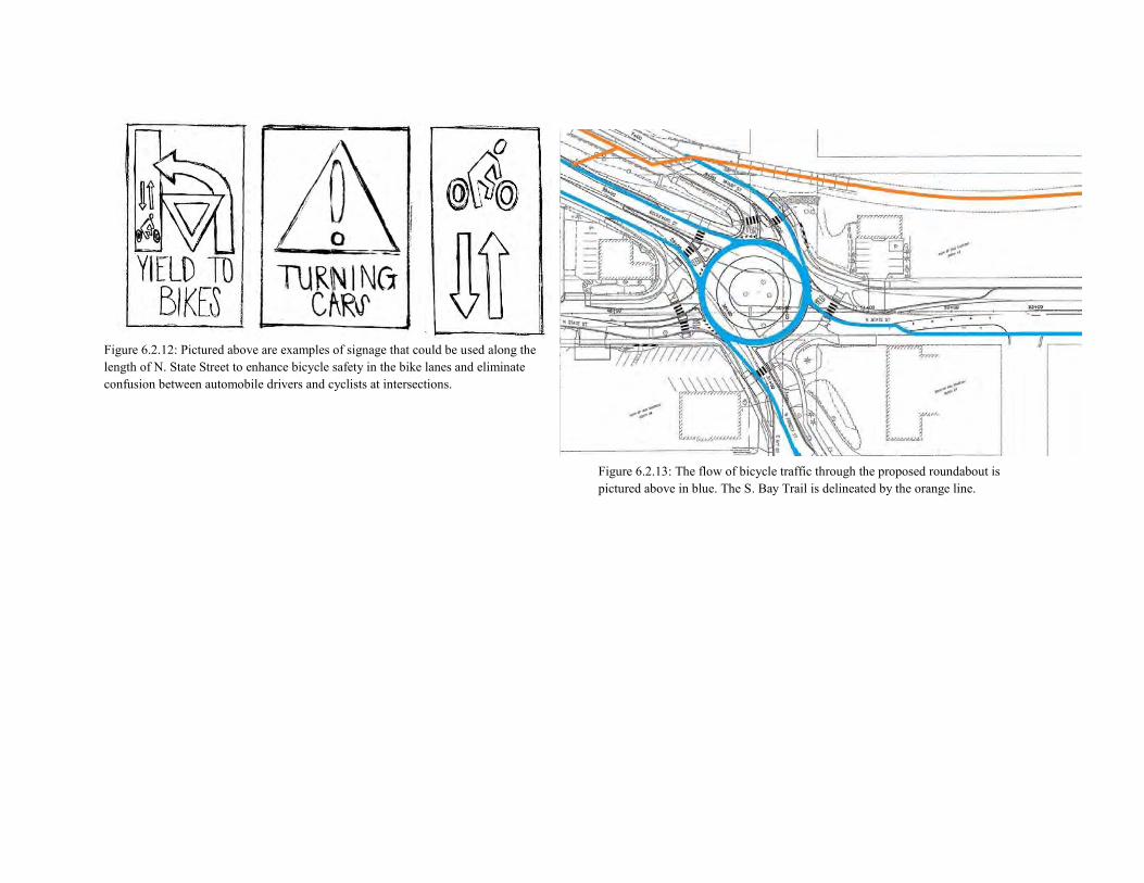
Figure 6.2.12: Pictured above are examples of signage that could be used along the length of N. State Street to enhance bicycle safety in the bike lanes and eliminate confusion between automobile drivers and cyclists at intersections.
Figure 6.2.13: The flow of bicycle traffic through the proposed roundabout is pictured above in blue. The S. Bay Trail is delineated by the orange line.
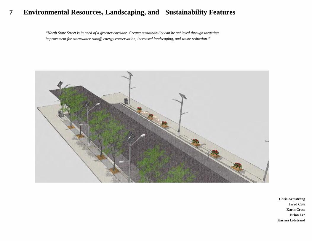
Chris Armstrong
Jared Cole Karin Cross
Brian Lee Karissa Lidstrand
7 Environmental Resources, Landscaping, and Sustainability Features
“North State Street is in need of a greener corridor. Greater sustainability can be achieved through targeting improvement for stormwater runoff, energy conservation, increased landscaping, and waste reduction.”
Table of Contents 7.1 Introduction Vision Statement 7.2 Objectives Environmental Resources Restore Whatcom Creek Landscaping Identify Appropriate Vegetation Create Tree Corridor Sustainability Reduce Stormwater Runoff Utilize Existing Features Increase Energy Independence Waste Reduction 7.3 Opportunities and Constraints Opportunities Water Sidewalk Constraints Curb Placement/Right of Way Plant Specifications 7.4 Recommendations Environmental Resources Whatcom Creek Landscaping Tree Plan Potted Vegetation Sustainability LED Lights Trash and Recycling Water Catchment Feature Bioswale
7.1 Introduction This section of the report focuses on the opportunities for improving and restoring the environmental resources, landscaping, and sustainability features of North State Street. The intent of this section is to propose recommendations that will enhance the sustainability of the study corridor through utilization of naturally occurring resources and emergent technology. Additionally, these recommendations will serve to create a stronger community through an increase in perceived connectivity. This increase will be achieved through comprehensive landscaping features and restoration of environmental resources. These objectives are already reflected throughout greater Bellingham and will grow more important as the city attempts to create opportunities for grater population density while promoting enhanced livability in the downtown community. Vision Statement North State Street has tremendous potential to accommodate future population growth within Bellingham. However, as a major arterial it is heavily traveled and as a consequence results in auto intensive noise and air pollution. As a vital part of downtown Bellingham’s future this corridor needs to both facilitate current traffic and transform into a vibrant section of the downtown community. Sustainability features should be integrated into the streetscape to promote the human scale experience. By providing unique environmental amenities, North State Street can encourage green living among residents and visitors alike. Design tailored to the enhancement of the sidewalk culture, in addition to making all of State Street more sustainable are top priorities. 7.2 Objectives Environmental Resources Environmental resources are existing and created natural features that provide benefits or services to the immediate or extended community. Restore Whatcom Creek Whatcom Creek is a vital yet underutilized water resource on the north end of the study corridor. The Creek is a major catchment for stormwater runoff in the northern section of downtown Bellingham. As such, it is important that it is maintained and has the ability to filter pollutants while still providing habitat for native species. It is also an attraction that brings visitors to the downtown and therefore should also be enhanced for recreational purposes.
Landscaping Identify Appropriate Vegetation North State Street currently lacks an engaging and consistent vegetation scheme. Where there is vegetation it neither creates an strong edge to the street nor relates to pedestrian scale. In addition there is a wide variety of trees and potted vegetation that doesn’t link the street into a comprehensive landscaping theme. Adding vegetation through potted plants, vegetative strips along the sidewalk, or hanging baskets could all enhance the visual aesthetic and promote a human scale experience for the street. Plants also reflect, rather than absorb sunlight, which adds to the urban cooling effect along State Street. Create Tree Corridor The lack of a consistent tree type and planting pattern detracts from the perceived aesthetics and visual connectivity of the corridor. Providing several species and styles throughout the corridor will enhance the street legibility as well as promote State Street’s unique urban identity. Sustainability Reduce Stormwater Runoff As an increasingly urban environment, management of runoff in downtown Bellingham is recognized in City plans and policies as a priority. With additional increases in population density there will be more impervious surfaces will likely be created, leading to increases in stormwater. While conventional methods of channeling and treatment are important, there will be a need for advancements in infrastructure to reduce runoff altogether. Implementing such infrastructure will not only enhance the sustainability of the street but will also lessen the burden on existing stormwater facilities. Utilize Existing Features North State Street has an abundant variety of features that can be preserved, enhanced, or integrated into a corridor wide sustainability plan. Utilizing existing features provides continuity to the community. Keeping the sidewalk as it exists, reduces infrastructure cost for the site and allows for proposed ideas, such as a grated bioswales. Rain is a prominent condition in Bellingham, utilizing this via a rainwater catchment system takes advantage of natural conditions.
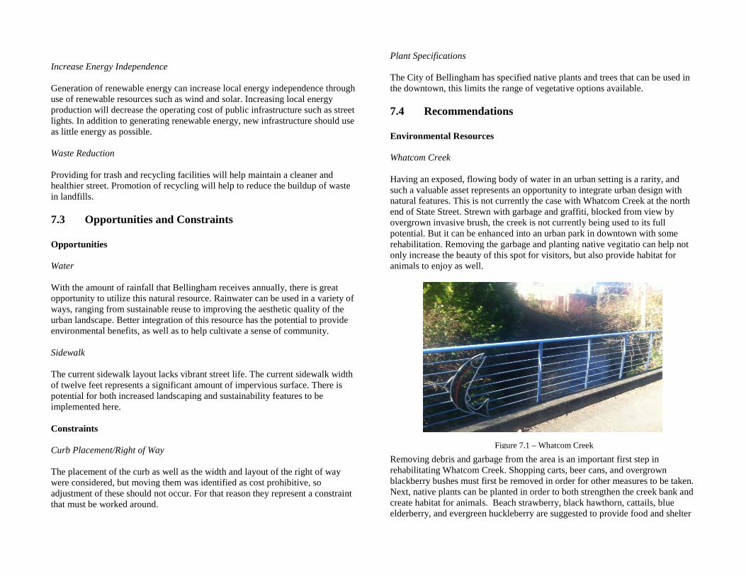
Increase Energy Independence Generation of renewable energy can increase local energy independence through use of renewable resources such as wind and solar. Increasing local energy production will decrease the operating cost of public infrastructure such as street lights. In addition to generating renewable energy, new infrastructure should use as little energy as possible. Waste Reduction Providing for trash and recycling facilities will help maintain a cleaner and healthier street. Promotion of recycling will help to reduce the buildup of waste in landfills. 7.3 Opportunities and Constraints Opportunities Water With the amount of rainfall that Bellingham receives annually, there is great opportunity to utilize this natural resource. Rainwater can be used in a variety of ways, ranging from sustainable reuse to improving the aesthetic quality of the urban landscape. Better integration of this resource has the potential to provide environmental benefits, as well as to help cultivate a sense of community. Sidewalk The current sidewalk layout lacks vibrant street life. The current sidewalk width of twelve feet represents a significant amount of impervious surface. There is potential for both increased landscaping and sustainability features to be implemented here. Constraints Curb Placement/Right of Way The placement of the curb as well as the width and layout of the right of way were considered, but moving them was identified as cost prohibitive, so adjustment of these should not occur. For that reason they represent a constraint that must be worked around.
Plant Specifications The City of Bellingham has specified native plants and trees that can be used in the downtown, this limits the range of vegetative options available. 7.4 Recommendations Environmental Resources Whatcom Creek Having an exposed, flowing body of water in an urban setting is a rarity, and such a valuable asset represents an opportunity to integrate urban design with natural features. This is not currently the case with Whatcom Creek at the north end of State Street. Strewn with garbage and graffiti, blocked from view by overgrown invasive brush, the creek is not currently being used to its full potential. But it can be enhanced into an urban park in downtown with some rehabilitation. Removing the garbage and planting native vegitatio can help not only increase the beauty of this spot for visitors, but also provide habitat for animals to enjoy as well.
Removing debris and garbage from the area is an important first step in rehabilitating Whatcom Creek. Shopping carts, beer cans, and overgrown blackberry bushes must first be removed in order for other measures to be taken. Next, native plants can be planted in order to both strengthen the creek bank and create habitat for animals. Beach strawberry, black hawthorn, cattails, blue elderberry, and evergreen huckleberry are suggested to provide food and shelter
Figure 7.1 – Whatcom Creek
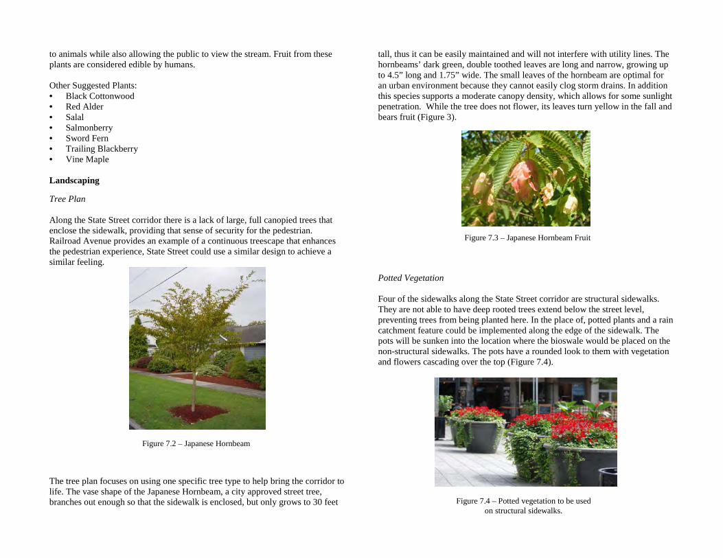
to animals while also allowing the public to view the stream. Fruit from these plants are considered edible by humans. Other Suggested Plants: • Black Cottonwood • Red Alder • Salal • Salmonberry • Sword Fern • Trailing Blackberry • Vine Maple Landscaping
Tree Plan Along the State Street corridor there is a lack of large, full canopied trees that enclose the sidewalk, providing that sense of security for the pedestrian. Railroad Avenue provides an example of a continuous treescape that enhances the pedestrian experience, State Street could use a similar design to achieve a similar feeling.
The tree plan focuses on using one specific tree type to help bring the corridor to life. The vase shape of the Japanese Hornbeam, a city approved street tree, branches out enough so that the sidewalk is enclosed, but only grows to 30 feet
tall, thus it can be easily maintained and will not interfere with utility lines. The hornbeams’ dark green, double toothed leaves are long and narrow, growing up to 4.5” long and 1.75” wide. The small leaves of the hornbeam are optimal for an urban environment because they cannot easily clog storm drains. In addition this species supports a moderate canopy density, which allows for some sunlight penetration. While the tree does not flower, its leaves turn yellow in the fall and bears fruit (Figure 3).
Potted Vegetation Four of the sidewalks along the State Street corridor are structural sidewalks. They are not able to have deep rooted trees extend below the street level, preventing trees from being planted here. In the place of, potted plants and a rain catchment feature could be implemented along the edge of the sidewalk. The pots will be sunken into the location where the bioswale would be placed on the non-structural sidewalks. The pots have a rounded look to them with vegetation and flowers cascading over the top (Figure 7.4).
Figure 7.2 – Japanese Hornbeam
Figure 7.3 – Japanese Hornbeam Fruit
Figure 7.4 – Potted vegetation to be used on structural sidewalks.
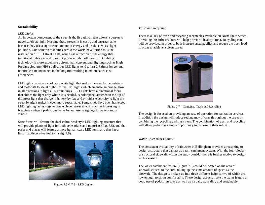
Sustainability
LED Lights An important component of the street is the lit pathway that allows a person to travel safely at night. Keeping these streets lit is costly and unsustainable because they use a significant amount of energy and produce excess light pollution. One solution that cities across the world have turned to is the installation of LED street lights, which use a fraction of the energy that traditional lights use and does not produce light pollution. LED lighting technology is more expensive upfront than conventional lighting such as High Pressure Sodium (HPS) bulbs, but LED lights tend to last 2-3 times longer and require less maintenance in the long run resulting in maintenance cost efficiencies. LED lights provide a cool crisp white light that makes it easier for pedestrians and motorists to see at night. Unlike HPS lights which emanate an orange glow in all directions to light all surroundings, LED lights have a directional focus that shines the light only where it is needed. A solar panel attached to the top of the street light that charges a battery by day and provides electricity to light the street by night makes it even more sustainable. Some cities have even harnessed LED lighting technology to create clever street effects, such as increasing in brightness when a pedestrian walks by and use in signage to make it more visible. State Street will feature the dual-cobra-head style LED lighting structure that will provide plenty of light for both pedestrians and motorists (Fig. 7.5), and the parks and plazas will feature a more human-scale LED luminaire that has a historical/decorative feel to it (Fig. 7.6).
Trash and Recycling There is a lack of trash and recycling receptacles available on North State Street. Providing this infrastructure will help provide a healthy street. Recycling cans will be provided in order to both increase sustainability and reduce the trash load in order to achieve a clean street.
The design is focused on providing an ease of operation for sanitation services. In addition the design will reduce redundancy of cans throughout the street by combining the recycling and trash cans. The combination of trash and recycling will allow pedestrians ample opportunity to dispose of their refuse.
Water Catchment Feature The consistent availability of rainwater in Bellingham provides a reasoning to design a structure that can act as a rain catchment system. With the four blocks of structural sidewalk within the study corridor there is further motive to design such a system. The water catchment feature (Figure 7.8) could be located on the area of sidewalk closest to the curb, taking up the same amount of space as the bioswale. The design is broken up into three different heights, two of which are low enough to sit on comfortably. These design aspects make the water feature a good use of pedestrian space as well as visually appealing and sustainable. Figures 7.5 & 7.6 – LED Lights.
Figure 7.7 – Combined Trash and Recycling
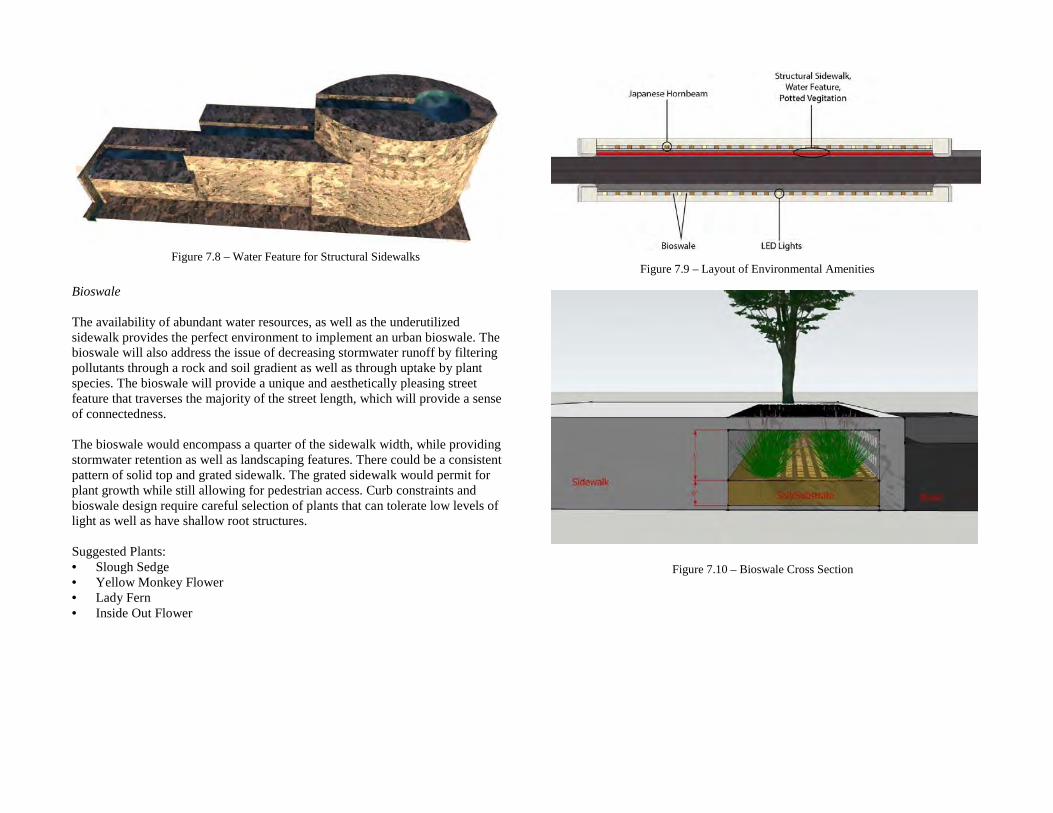
Bioswale The availability of abundant water resources, as well as the underutilized sidewalk provides the perfect environment to implement an urban bioswale. The bioswale will also address the issue of decreasing stormwater runoff by filtering pollutants through a rock and soil gradient as well as through uptake by plant species. The bioswale will provide a unique and aesthetically pleasing street feature that traverses the majority of the street length, which will provide a sense of connectedness. The bioswale would encompass a quarter of the sidewalk width, while providing stormwater retention as well as landscaping features. There could be a consistent pattern of solid top and grated sidewalk. The grated sidewalk would permit for plant growth while still allowing for pedestrian access. Curb constraints and bioswale design require careful selection of plants that can tolerate low levels of light as well as have shallow root structures. Suggested Plants: • Slough Sedge • Yellow Monkey Flower • Lady Fern • Inside Out Flower
Figure 7.9 – Layout of Environmental Amenities
Figure 7.10 – Bioswale Cross Section
Figure 7.8 – Water Feature for Structural Sidewalks
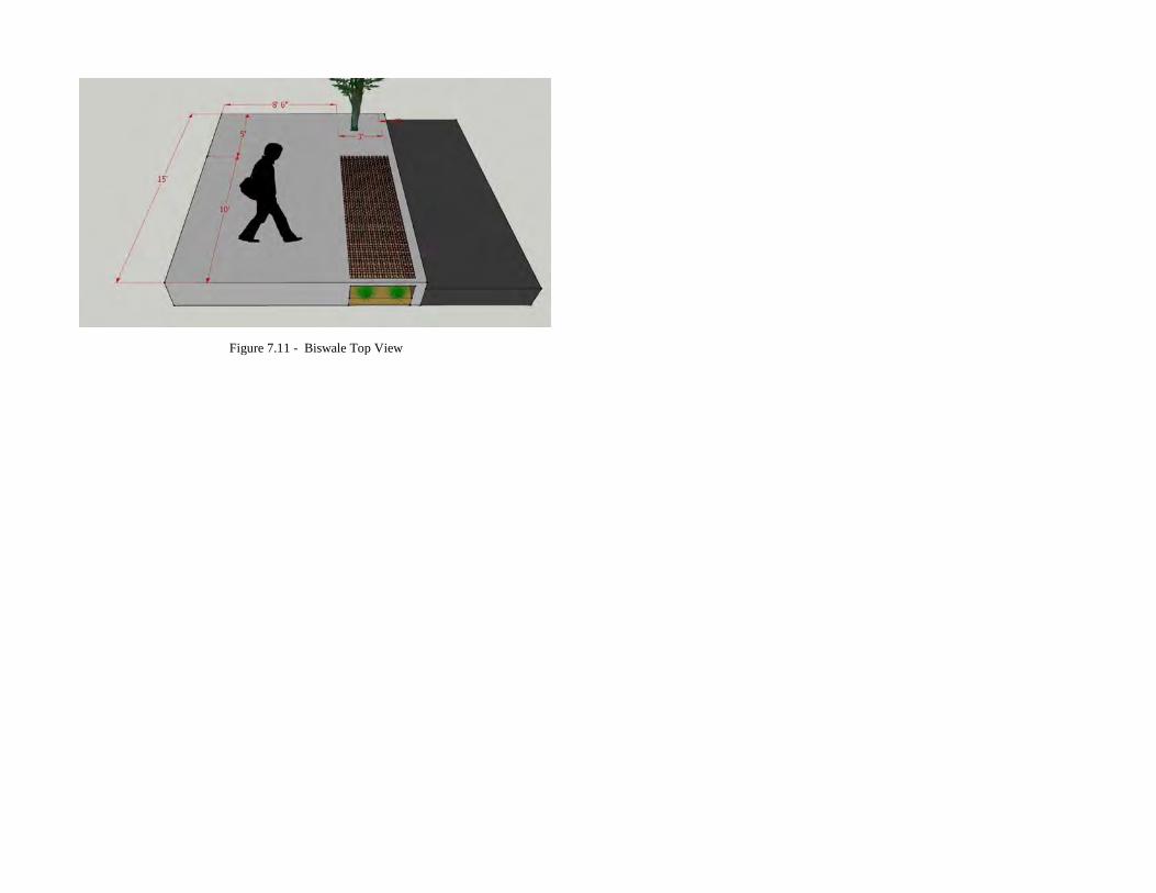
Figure 7.11 - Biswale Top View


![AIR Studio 2013 [A2]](https://img.pdfslide.us/doc/110x75/568bdf591a28ab2034bcc303/air-studio-2013-a2.jpg)