Embed Size (px)
Citation preview

1-1
Chapter 1: Project Description
A. INTRODUCTION Cornell University, together with the New York City Economic Development Corporation (NYCEDC) and the New York City Department of Citywide Administrative Services, is seeking a number of discretionary approvals (the “proposed actions”) to support and allow for the development of an applied science and engineering campus on Roosevelt Island (the “proposed project”). These actions include the disposition of City-owned property and the approval of the lease and sale terms for the disposition; a modification of the Roosevelt Island Operating Corporation (RIOC) lease with the City; an amendment of the New York City Health and Hospitals (NYCHHC) operating agreement with the City; zoning map and text amendments; and a City map amendment.
As shown on Figure 1-1, the project site is located on the southern portion of Roosevelt Island, south of the Ed Koch Queensboro Bridge. A majority of the project site (Block 1373, Lot 20) is owned by the City of New York and is occupied by the Coler-Goldwater Specialty Hospital and Nursing Facility’s Goldwater Memorial Hospital (Goldwater Hospital), which is operated by NYCHHC. The remainder of the project site (Block 1372, part of Lot 1) is vacant and owned by the City of New York and leased to RIOC. Figure 1-2 shows the project site and reflects its current ownership. Independently of, and prior to, the proposed project, NYCHHC will vacate the Goldwater Hospital and relocate patients and services elsewhere.1 Outside of the hospital site, the Island is controlled by RIOC, under a long-term lease with the City.2 North of the Queensboro Bridge, Roosevelt Island is a predominantly residential community with community facility, open space, and transportation and utility uses. It is under the political jurisdiction of the borough of Manhattan.
Under the terms of an agreement between the City of New York and NYCEDC Cornell is required to build a total of 300,000 gsf of building space in Phase 1, of which a minimum of 200,000 gsf must be for academic use. Phase 2 requirements include a cumulative total of 1.8 million gsf of building space, of which 620,000 gsf must be for academic use.
Academic use is defined as classrooms, offices for academic personnel, technology transfer offices, laboratories, teaming areas, lecture halls, incubators and accelerators, seminar and meeting rooms (for academic purposes), other uses primarily for teaching, learning and/or academic research, and other ancillary facilities for the use and convenience of academic personnel such as lounges, dining areas and similar facilities. Permitted non-academic uses 1 NYCHHC issued a Negative Declaration on December 6, 2011 for the closure and relocation of operations
currently housed at the Goldwater Hospital (CEQR No. 12HHC001M). 2 Roosevelt Island is owned by the City of New York, and the entire Island except for the Goldwater Hospital
campus and the Coler Memorial Hospital campus is leased to the State of New York. RIOC was established by New York State in 1984 to manage the operation, maintenance, and development of the Island. The State's lease on the Island expires in 2068, when control will revert to New York City.

FIR
ST A
V
SE
CO
ND
AV
10 S
T
THIR
D A
V
21 S
T9
ST
11 S
T
12 S
T23
ST
22 S
T
YOR
K A
V
E 73 ST
E 74 ST
40 AV
E 72 ST
41 AV
VE
RN
ON
BLV
D
E 71 ST
E 75 ST
E 70 ST
43 AV
E 76 ST
WES
T R
D
E 68 ST
38 AV
27 S
T
E 69 ST
24 S
T
44 AV
E 67 ST
37 AV
E 77 ST
E 78 ST
MAI
N S
T
E 65 ST
13 S
T
EAST
RD
36 AV
E 64 ST
E 62 ST
QUEENSBORO BR
44 RD
E 63 ST
E 61 ST
E 79 ST
28 S
T
E 60 ST
44 DR
35 AV
E 66 ST
E 59 ST
F D
R D
R
E 80 ST
39 AV
PAR
K A
V
34 AV
E 58 ST
E 57 ST
LEX
ING
TON
AV
42 RD
E 56 ST
E 55 ST
E 81 ST
43 RD
14 S
T
E 54 ST
29 S
T
CR
ESC
ENT
ST
33 RD
E 53 ST
45 AV
QN PLZ
E 52 ST
E 82 ST
41 RD
EAS
T E
ND
AV
E 83 ST
E 51 ST
MA
DIS
ON
AV
E 50 ST
RAMP
5 S
T 24 S
T
9 ST
10 S
T
12 S
T
12 S
T
22 S
T
F D
R D
R
EAST
RD
13 S
T
41 A
V
11 S
T
ROOSEVELT
ISLAND BR
ED KOCH
Midtown
Upper East Side
Turtle Bay
Long Island City
Astoria
ROOSEVELTISLAND
QUEENSQUEENS
MANHATTANMANHATTAN
1
1
2
3
4
2
3
45
6
7
8
9
5
6
7
8
9
SCALE
0 500 1000 FEET
N
Project LocationFigure 1-1
EAST
RIV
ER
10.9.12
Cornell NYC Tech
Project Site
Rezoning Area (Special SouthernRoosevelt Island District)
Four Freedoms Park (Under Construction)
South Point Park
Sportspark
Tram Station
Steam Plant
Southtown
Northtown
Motorgate
Coler Memorial Hospital Campus

SCALE
0 200 400 FEET
N
Project Site: Current OwnershipFigure 1-2
INSET - Area of Detail
SEE INSET
A
A
B C DE FJ
10.9.12
Cornell NYC Tech
Project Site
Rezoning Area (Special Southern Roosevelt Island District)
Goldwater Hospital Building Name
DEP South Pump Station
Traffic Direction
Block 1373 Lot 20 Owned by: City of New York Occupied by: Goldwater Memorial Hospital (NYCHHC)
Block 1373 Lot 1 (portion) Owned by: City of New York Leased to: RIOC
Cornell NYC Tech DEIS
1-2
include community uses, residential buildings for academic personnel (including student lounges located therein), ancillary recreational uses, visitor lodging, eating and drinking establishments, corporate co-location space for technology-related businesses, and other uses ancillary to the academic uses.
Construction of the Cornell NYC Tech project is expected to begin in 2014 with the first phase of the project expected to begin operations on Roosevelt Island in Summer 2017; 2018 will be the first full year of operation.3 Phase 1 is anticipated to consist of up to 790,000 gross square feet (gsf) of development consisting of approximately 200,000 gsf of academic space, 100,000 gsf of corporate co-location space, approximately 300,000 gsf of residential space (442 units), and 170,000 gsf for an Executive Education Center with hotel and conference facilities. Up to another 20,000 gsf could be developed as a central utility plant, and up to 250 parking spaces could be provided. Phase 2, expected to be completed by 2038, is anticipated to add a maximum of 1.34 million gsf consisting of approximately 420,000 gsf of academic space, 400,000 gsf of corporate co-location space, 500,000 gsf of residential space (652 units), and possibly another 20,000 gsf central utility plant. In total, the maximum potential Cornell NYC Tech project program is assumed to comprise up to 2.13 million gsf of development consisting of 620,000 gsf of academic space, 500,000 gsf of corporate co-location space, 800,000 gsf of residential space (1,094 units), 170,000 gsf for the Executive Education Center, and 40,000 gsf for the central utility plants. Up to approximately 25,000 gsf of campus-oriented retail could be provided within this program, and at full build, up to 500 parking spaces could also be provided.
This environmental impact statement (EIS) has been prepared in conformance with the State Environmental Quality Review Act (SEQRA) (Article 8 of the New York State Environmental Conservation Law) and its implementing regulations found at 6 NYCRR Part 617, New York City Executive Order No. 91 of 1977, as amended, and the Rules of Procedure for City Environmental Quality Review (CEQR), found at Title 62, Chapter 5 of the Rules of the City of New York. The EIS follows the guidance of the CEQR Technical Manual, dated June 2012. The Office of the Deputy Mayor for Economic Development (ODMED) is the CEQR lead agency for this proposal.
B. APPLIED SCIENCES NYC INITIATIVE AND PURPOSE AND NEED FOR THE CORNELL NYC TECH PROJECT
The City of New York launched its Applied Sciences4 NYC initiative in 2010 after working with a range of New York City’s business leaders, academics, community groups, and entrepreneurs to identify ambitious, achievable initiatives that the city could undertake to attain local economic growth. From that process, an unmet demand within New York City for top-flight engineers and applied scientists was identified.
The purpose of the Applied Sciences competition in New York City was to provide an opportunity for one or more leading academic institutions to build world-class applied sciences and engineering campuses in New York City. The overarching goal is to maintain and increase New York City’s global competitiveness, diversify the city’s economy, drive economic growth, and create jobs for New Yorkers.
3 Cornell opened a portion of its Cornell NYC Tech academic program in leased space in New York City in
2012. Leasing such space did not require any governmental approvals. 4 Applied sciences is the discipline of applying scientific knowledge from one or more fields to practical
problems.
Chapter 1: Project Description
1-3
In December 2010, the city issued a Request for Expressions of Interest to gauge universities’ interest in developing and operating a new applied science and engineering research campus in New York City. In connection with the new campus, the city indicated its willingness to provide city-owned land in addition to a significant capital contribution in site infrastructure. In 2011, the city issued a Request for Proposals (RFP) seeking a university, institution or consortium to develop and operate a new (or expanded) campus in the city. The city selected Cornell University, in conjunction with its academic partner the Technion - Israel Institute of Technology, to develop the Applied Sciences NYC project at the Goldwater Hospital site on Roosevelt Island—the Cornell NYC Tech project.
The Cornell NYC Tech project intends to focus on research in the applied sciences and fields of study related to the technology sector. A defining aspect of the new campus’s graduate-level academic programs is the close tie to business and entrepreneurship that will be woven throughout the curriculum. Research will be focused on technology in application areas that have commercial potential in New York City markets. Specifically, New York City’s technology sector and information-driven economy serves as the impetus for the development of many consumer-oriented companies focused specifically on technology to meet end users’ needs, including some of NYC’s core industries: media, advertising, finance, healthcare, real estate, construction, and design. The Cornell NYC Tech campus will be centered on flexible and dynamic interdisciplinary application hubs instead of traditional academic departments. This model will serve as a focal point for accelerating existing sectors of NYC’s economy and driving the formation of new technology businesses through close ties to customers and core industry knowledge.
C. SITE CONDITIONS The project site, which consists of Manhattan Block 1373, Lot 20 and a portion of Lot 1, is located on the southern portion of Roosevelt Island and totals approximately 12.5 acres.
Goldwater Hospital opened on the Island in 1939 as a chronic care and nursing facility. As shown on Figure 1-2, the facility consists of the original six-building complex (Buildings A through F) and a circa 1971 addition (Building J). In 1996, Goldwater Hospital and Coler Memorial Hospital (which is located on the northern portion of the Island) merged to become Coler-Goldwater Specialty Hospital and Nursing Facility. As part of a major modernization planning effort, including the relocation of Goldwater Hospital patients and services, that has been on-going since approximately 2007, NYCHHC will move current Goldwater Hospital activities to other facilities and vacate the Goldwater Hospital site. Cornell would receive the site after it has been vacated, demolition of the existing and vacant hospital buildings would occur as part of the proposed Cornell NYC Tech project. Chapter 2, “Land Use, Zoning, and Public Policy,” provides more detail on NYCHHC’s plans to vacate the project site.
A sanitary pump station, owned and maintained by the New York City Department of Environmental Protection (NYCDEP) is located in a fenced area on the southeast corner of the project site (see Figure 1-2). This pump station is called the South Pump Station, and it collects sanitary sewage from the buildings south of the Queensboro Bridge and pumps these flows to a gravity sewer within Main Street that eventually discharges to Roosevelt Island’s main pump station.
As shown on Figure 1-2, a one‐way loop road encircles the project site with traffic flow in a clockwise direction (i.e., southbound on the roadway east of the site, westbound on the roadway south of the site, and northbound to the west of the site). To the north of the site, the street is westbound.

Cornell NYC Tech DEIS
1-4
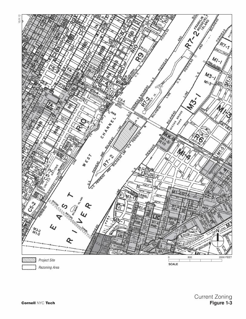
A promenade that is not part of the project site extends along the east and west sides of Roosevelt Island along the entirety of its waterfront north of South Point Park, providing a walkway for pedestrians; a concrete seawall forms the barrier along the East River. The project site, like all of Roosevelt Island, is zoned R7-2, a medium-density residential designation (see Figure 1-3).
D. CORNELL NYC TECH PROJECT PLANNING INTRODUCTION
Cornell has a long history and a strong presence within New York City. Founded in Ithaca New York in 1865, Cornell University first established a presence in New York City in 1898, with the founding of what is now known as the Weill Cornell Medical College (WCMC). WCMC began an affiliation with New York Hospital in 1913 and subsequently with what is now New York-Presbyterian Hospital (1998). The Graduate School of Medical Sciences was founded in 1952 (convergence of two institutions—Sloan-Kettering Institute and Weill Cornell Medical College). Cornell’s Joan and Sanford I. Weill Medical College and Weill Cornell Graduate School of Medical Sciences are located on the Upper East Side of Manhattan between 65th and 72nd Streets.
In addition to medical studies, Cornell has a number of other active academic programs in Manhattan, including programs in financial engineering, labor relations, architecture and planning, and cooperative extension. Continuing its long connection with New York City, and consistent with Cornell’s plan to expand its engineering and technology programs, in 2011, Cornell responded to the city’s RFP to build a world-class applied sciences and engineering campus in New York City. Following selection by New York City, Cornell has undertaken various planning activities for the Cornell NYC Tech project, including campus framework planning as discussed in the next section.
CAMPUS FRAMEWORK
Cornell is developing a Campus Framework to guide development of the proposed project. The framework will include a discussion of principles that will guide design and implementation of the campus; strategies for campus operations (e.g., vehicular and pedestrian circulation, service access and loading, and parking); principles for site design, including sustainability goals and strategies to meet these goals; and design guidelines that would apply to the campus as a whole and to individual parcels and the site’s open spaces. The framework is intended to guide development while allowing Cornell flexibility in implementing the plan over the project’s long build out period. This section summarizes that framework.
CAMPUS FRAMEWORK PRINCIPLES
The campus framework principles are intended to inform the campus design, and consist of the following:
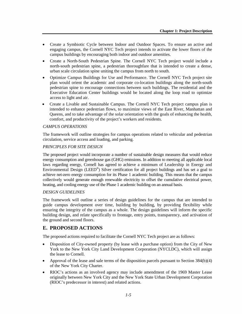
• Create a River to River Campus Vision. The Cornell NYC Tech project intends to create a campus that will recognizes the existing Roosevelt Island promenade and the Island’s water frontage as important adjacent elements of the campus site.
• Create a Diverse Collection of Active Open Spaces. The Cornell NYC Tech project intends to create a diverse array of publicly-accessible open spaces that extend from the loop road into the campus. Cornell intends to design and program these spaces so that each space is clearly defined in its character and use. The site’s open spaces are also intended to facilitate movement within the campus, both north to south and east to west.
SCALE
0 800 2000 FEET
N
Current ZoningFigure 1-3
10.9.12
Cornell NYC Tech
Project Site
Rezoning Area
Chapter 1: Project Description
1-5
• Create a Symbiotic Cycle between Indoor and Outdoor Spaces. To ensure an active and engaging campus, the Cornell NYC Tech project intends to activate the lower floors of the campus buildings by encouraging both indoor and outdoor amenities.
• Create a North-South Pedestrian Spine. The Cornell NYC Tech project would include a north-south pedestrian spine, a pedestrian thoroughfare that is intended to create a dense, urban scale circulation spine uniting the campus from north to south.
• Optimize Campus Buildings for Use and Performance. The Cornell NYC Tech project site plan would orient the academic and corporate co-location buildings along the north-south pedestrian spine to encourage connections between such buildings. The residential and the Executive Education Center buildings would be located along the loop road to optimize access to light and air.
• Create a Livable and Sustainable Campus. The Cornell NYC Tech project campus plan is intended to enhance pedestrian flows, to maximize views of the East River, Manhattan and Queens, and to take advantage of the solar orientation with the goals of enhancing the health, comfort, and productivity of the project’s workers and residents.
CAMPUS OPERATIONS
The framework will outline strategies for campus operations related to vehicular and pedestrian circulation, service access and loading, and parking.
PRINCIPLES FOR SITE DESIGN
The proposed project would incorporate a number of sustainable design measures that would reduce energy consumption and greenhouse gas (GHG) emissions. In addition to meeting all applicable local laws regarding energy, Cornell has agreed to achieve a minimum of Leadership in Energy and Environmental Design (LEED®) Silver certification for all project buildings and has set a goal to achieve net-zero energy consumption for its Phase 1 academic building. This means that the campus collectively would generate enough renewable electricity to offset the cumulative electrical power, heating, and cooling energy use of the Phase 1 academic building on an annual basis.
DESIGN GUIDELINES
The framework will outline a series of design guidelines for the campus that are intended to guide campus development over time, building by building, by providing flexibility while ensuring the integrity of the campus as a whole. The design guidelines will inform the specific building design, and relate specifically to frontage, entry points, transparency, and activation of the ground and second floors.
E. PROPOSED ACTIONS The proposed actions required to facilitate the Cornell NYC Tech project are as follows:
• Disposition of City-owned property (by lease with a purchase option) from the City of New York to the New York City Land Development Corporation (NYCLDC), which will assign the lease to Cornell.
• Approval of the lease and sale terms of the disposition parcels pursuant to Section 384(b)(4) of the New York City Charter.
• RIOC’s actions as an involved agency may include amendment of the 1969 Master Lease originally between New York City and the New York State Urban Development Corporation (RIOC’s predecessor in interest) and related actions.

Cornell NYC Tech DEIS
1-6
• Amendment of the NYCHHC operating agreement with the city by the Corporation Board in order to surrender a portion of the project site (Block 1373, Lot 20).
• Zoning Map amendment to change the project site and surrounding area zoning from R7-2 to C4-5, and to establish the Special Southern Roosevelt Island District over the same area, as shown on Figure 1-4 (the “rezoning area”). R7-2 districts allow residential uses at a maximum Floor Area Ratio (FAR) of 3.44, and community facility uses with a maximum FAR of 6.5. Commercial uses and manufacturing uses are not permitted under the R7-2 zoning designation. The proposed C4-5/Special Southern Roosevelt Island District zoning designation would allow for the commercial uses anticipated with the project up to a maximum FAR of 3.4. Residential uses in the C4-5/Special Southern Roosevelt Island District would be permitted to a maximum FAR of 3.44, and community facility uses would be allowed to a maximum FAR of 6.5. Use Group 17B research labs would also be allowed under the C4-5/Special Southern Roosevelt Island District, to a maximum FAR of 3.4.
• Zoning Text amendment to create the Special Southern Roosevelt Island District and to establish special bulk, use, parking, and public access controls for the rezoning area. The Special District is intended to create a uniform, flexible framework for the ongoing development of the Cornell NYC Tech campus. The proposed Special Southern Roosevelt Island District text and accompanying maps are presented in Appendix 1. The Special District goals include the following specific purposes:
- To provide opportunities for the development of an academic and research and development campus in a manner that benefits the surrounding community;
- To allow for a mix of residential, retail, and other commercial uses to support the academic and research and development facilities and complement the urban fabric of Roosevelt Island;
- To establish a network of publicly accessible open areas that take advantage of the unique location of Roosevelt Island and that integrate the academic campus into the network of open spaces on Roosevelt Island and provide a community amenity;
- To strengthen visual and physical connections between the eastern and western shores of Roosevelt Island by establishing publicly accessible connections through the Special District and above grade view corridors;
- To encourage alternative forms of transportation by eliminating required parking and placing a maximum cap on permitted parking;
- To provide flexibility of architectural design within limits established to assure adequate access of light and air to the street and surrounding waterfront open areas, and thus to encourage more attractive and innovative building forms; and
- To promote the most desirable use of land in this area and thus conserve the value of land and buildings, and thereby protect the city’s tax revenues.
Properties within the proposed Special Southern Roosevelt Island District would be subject to special bulk, use, parking, and public access provisions that would supplement or supersede the underlying zoning district.
• City Map Amendment to map the one-way loop road surrounding the project site and its connection to Main Street as a city street (see Figure 1-5). As shown on the figure, the roadway would be called West Loop Road to the west of the site, North Loop Road to the north of the site, East Loop Road to the east of the site, and South Loop Road to the south of the site. The

SCALE
0 800 2000 FEET
N
Proposed ZoningFigure 1-4
C4-5
SPEC
IAL S
OUTH
ERN
ROOS
EVEL
T ISL
AND
DIST
RICT
10.9.12
Cornell NYC Tech
Project Site
Rezoning Area (C4-5 Special Southern Roosevelt Island District)

R=486.00<=10°-46'-48"L=91.44
R=1000.00<=10°-46'-48"L=188.15
256.36
284.15
R=96.00<=94°-37'-16"L=158.54
R=116.00<=19°-29'-22"L=39.46
106.04 21'38'
8'
8'8'
MAIN STREET
RAD.
RAD.
<=35°-44'-31"
<=48°-49'-30"
<=155°-21'-15"
<=146°-23'-07"
RAD.R
AD
.
P.T.
P.C.
P.T.P.C.
67
67 WID
TH
VA
RIE
S
R=24'
21.27
U.S. PIERHEAD AND BULKHEAD LINE
SHORE
R=478.00<=21°-13'-03"L=177.01
448.72
123.40
473.01
88.3871.55115.64126.6887.9415.54
139.8270.84
38.54
705.72
R=9.00<=111°-09'-59"L=17.46
R=2000.00<=6°-15'-02"L=218.67
R=2810.00<=4°-58'-41"L=244.14
P.C.
P.R.C
.
P.T.
90°-00'-0
7"
179°-5
6'-45"
178°-12'-09"
182°-55'-44"
187°-34'-33"
99°-10'-49"167°-22'-12"
1373
188°-20'-14"
179°-47'-18"
177°-53'-22"
119.29
155.2273.56
182°-40'-01"
182°-06'-38"
R=50.00<=81°-09'-07"L=70.82
R=33.0<=80°-49'-11"L=46.55
35.54
192°-37'-48"
90.17
172°-25'-27"
176°-38'-38"
112.90 71.05
177°-04'-16"
89.16
181°-47'-51"
R=2050.00<=6°-15'-02"L=224.13
473.06
180°-0
3'-15"
172.81
37.93
R=2860.00<=4°-58'-41"L=248.49
705.72
R=428.00<=21°-28'-37"L=160.43 44.03
121.91
P.T.
183°-21'-22"
15'32'
3'
50
15'32'
3'
50
15' 32' 9'56
15'32'3'50
P.C.
P.C.
P.T.P.T.
P.T.
P.C.
P.C.
P.C.
P.T.
P.C.
P.T.
P.T.
P.C.
1373
1373
1373
U.S. PIERHEAD AND BULKHEAD LINE
U.S. PIERHEAD AND BULKHEAD LINE
15'32'
3'
50
15'32'
3'
50
15'32'
3'
50
LOOP ROAD
WEST
LOOP
ROAD
EAST
SOUTH LOOP ROAD
NORTH LOOP ROAD
WEST MAIN STREET
100.00
117.73
175°-25'-3
4"
171°-39'-4
6"32.69
34.96
R=15.00<=81°-09'-07"L=21.25
45
45
15'32'
3'
50
15'32'
3'50
9' 32' 9'50
11.5' 38' 10.5'60
P.T.R=60.00<=18°-12'-35"L=19.07
P.R.C
.
R=125.00<=45°-12'-39"L=98.64
P.C.
294.79
P.T.
P.C.
R=100.00<=20°-14'-35"L=35.33
78.16
P.T.
R=86.00<=107°-42'-52"L=161.68
P.C.
R=50.00<=70°-07'-46"L=61.20
131.65
P.T.R=116.00<=59°-04'-21"L=119.60
<=174°-40'-29"
R=96.00<=42°-22'-11"L=70.99
R=40.00<=70°-58'-18"L=49.55
P.R.C.
P.R.C.
177.24
R=28.00<=87°-14'-48"L=42.64
307.96
R=522.00<=10°-38'-41"L=96.98185°-01'-26"
103.45
477.45
P.C.
P.T.
P.C.
P.T.92.44 P.C
.
84°-58'-27"
R=572.00<=10°-38'-41"L=106.27
P.T.
262.68
R=15.00<=87°-14'-48"L=22.84
P.C.
P.T.
273.85201.15
P.C.
R=36.00<=107°-42'-52"L=67.68
P.T.
78.16
P.T.
R=150.00<=20°-14'-35"L=53.00
294.79P.C.P.C.C.
R=75.00<=41°-53'-56"L=54.85
174°-3
2'-55"
100.00
185°-2
7'-05"43.52
41.26
181°-43'-09"
50
5015'
32'3'
WID
TH
VA
RIE
S
33.5'
15'32'3'
WIDTHVARIES
14.32
16.01
22.42
24.04
24.31
23.77
18.84
16.53
14.03
13.51
14.78
13.52
12.50
15.7515.1915.5614.5710.6111.36
12.89
15.81
17.24
16.64
15.05
14.09
12.64
13.74
10.6510.36
10.7710.38
14.6615.99 15.34
17.09
20.16
12.76
13.8811.54
P.C.
5615' 32' 9'
15'32'
3'
50
P.C.
EAST
EA
ST M
AIN
ST. MAIN
STREET
STREET
ST.
APPROX. EXISTINGLINE
APPROXIMATE
EXISTING
SHORELINE
P.C.P.T
.
8.5'3'
15'32'
3'50
APPROXIMATEEXISTING
SHORE
LINE
APPROXIMATE EXISTINGSHORE
LINE
473.01
473.06
705.72
705.72
21'38'
21'
186.59'
82.16'65.41'
197.62'62.80' 69.03' 40.08'
89.80' 73.53' 112.23' 96.96'
17.56'
61.31'103.35'
37.07'32.97' 23.68'
86.50'37.94'
51.98'
22.35' 173.79'
239.56'76.72'
38.32'
48.72'
85.32'
AS APPROVED BY THE SECRETARY OF WAR IN 1857, MODIFIED NOVEMBER 7, 1917
AS APPROVED BY THE SECRETARY OF WAR IN 1857, MODIFIED NOVEMBER 7, 1917
AS APPROVED BY THE SECRETARY OF WAR IN 1857,
AS APPROVED BY THE SECRETARY OF WAR IN 1857, MODIFIED NOVEMBER 7, 1917
U.S. PIERHEAD AND BULKHEAD LINE
MODIFIED NOVEMBER 7, 1917
30.41'
12.75
10.6110.90
10.72
12.77
11.74 13.36
14.47
13.90 47.73'
161.75'190.42'
144.37
44.81'10.00'11.58'
WE
ST
M
AIN
P.T.
R=20.00<=53°-40'-36"L=18.74
ED
KO
CH
BR
IDG
E (A
BO
VE
)
(QU
EE
NS
BO
RO
BR
IDG
E)
15.16'
14.94'
49.72'81.82'
61.28'
76.75'PRIVATE
SERVICE
ROAD
N12238.36E16710.26
N12300.60E16603.21
22.10 P
Proposed Roadway MappingFigure 1-5
Roadway Mapping Area
10.9.12
Cornell NYC Tech
N

Chapter 1: Project Description
1-7
portions of the roadways north of the project site that would connect to Main Street would be called West Main Street and East Main Street.
It is also possible that an approval from the U.S. Environmental Protection Agency (USEPA) would be required with respect to a geothermal well system that may be part of the project.
F. REASONABLE WORST-CASE DEVELOPMENT SCENARIO INTRODUCTION
As discussed above in Section E, “Proposed Actions,” the proposed actions include zoning and text amendments that would change the allowable development potential of the project site. Pursuant to this zoning, and beginning in 2014, over a period of approximately 24 years, Cornell anticipates building up to the following on the project site, which represents the maximum likely development program, or reasonable worst-case development scenario for purposes of analysis in this EIS:
• Three Cornell buildings for academic purposes. The academic buildings would accommodate classrooms (i.e., classrooms, lecture halls, seminar rooms, auditoria, meeting rooms, and breakout spaces), faculty and staff offices, research space for faculty and scientists,5 and space for commercial activities, from student projects to corporate-sponsored research. Ancillary space would also be provided for exhibits, interactive and social gatherings, cafés, and other amenities as well as meeting space for the adjacent Executive Education Center. Within the academic space (though possibly to be located in the corporate co-location buildings), there would be retail in support of the academic program; incubator space, with services and facilities that would support start-up businesses; accelerator space, where partnerships would be made between local accelerators and entrepreneurs; and demonstration space, with areas for venture capitalists, corporate partners, faculty, and students to come together to view and discuss new business and products.
• Two residential buildings to house campus leadership and faculty, postdoctoral fellows, Ph.D. candidates, and master’s students. The residential units would consist of a mix of studio, one-bedroom, and two-bedroom units.
• An Executive Education Center with hotel and conference facilities. The Executive Education Center would accommodate meetings, events, and conferences arising from the campus’s academic programs and commercial activities.
• Three corporate co-location buildings. These buildings would provide space for private companies that wish to take advantage of the proximity to Cornell’s academic activities and to Cornell’s faculty, researchers, and students. These buildings may also house academic space.
• A mixed-use building that comprises corporate co-location space at the base with a residential tower rising above the base for Cornell leadership, faculty, postdoctoral fellows, Ph.D. candidates, and master’s students.
• A modest amount of campus-oriented retail uses. Retail space would include uses such as a restaurant, cafés, newsstands, or a University bookstore and would serve the Cornell NYC Tech residents and workers.
• Two central utility buildings to serve the campus; and
5 The proposed project is not expected to include chemical or biological laboratories.

Cornell NYC Tech DEIS
1-8
• Publicly-accessible open space. The open spaces proposed for the site would have mixed programming, with some open spaces geared toward more active social engagement and others that would encourage quieter contemplation. The open space network would be designed to encourage movement within the campus. Under the proposed zoning text, at least 20 percent of the project site—or 2.5 acres—must be publicly-accessible open space. While it is Cornell’s intention to create more than this minimum requirement, for purposes of a conservative analysis, the EIS assumes the minimum amount of publicly-accessible open space.
In addition to these uses, parking may be provided for the Executive Education Center and for the three corporate co-location buildings. It is anticipated that up to 500 spaces could be provided at the project site, with 250 spaces in Phase 1 and another 250 spaces provided in Phase 2.
In support of the Cornell NYC Tech project, Con Edison would upgrade an existing gas line to Roosevelt Island. The upgrade would require the replacement of some piping and the change-out of pressure regulators within the Con Edison system.
Development of the project would require the demolition of the existing Goldwater Hospital buildings. As discussed above, independently of, and prior to, the proposed project, NYCHHC will vacate the Goldwater Hospital site and relocate patients and services elsewhere.
Table 1-1 summarizes the proposed development by use and by phase.
Table 1-1 Reasonable Worst-Case Development Program for CEQR (1)
Use
Phase 1: 2018 Phase 2: 2038 Full Build (Phases 1 and 2) GrossSquare
Footage Units/
Rooms/Spaces Gross Square
Footage Units/Rooms/
Spaces Gross Square
Footage Units/
Rooms/Spaces Academic 200,000 N/A 420,000 N/A 620,000 N/A Residential Housing (Total) (2)
Faculty Housing 104 142 246 Student Housing 338 510 848
Residential Total 300,000 442 500,000 652 800,000 1,094 Corporate Co-Location 100,000 N/A 400,000 N/A 500,000 N/A Executive Education Center (3) 170,000 225 0 N/A 170,000 225 Utility Plant 20,000 20,000 N/A 40,000 Parking 250 250 500 Total (4) 790,000 1,340,000 2,130,000 Notes: (1) Under the agreement between the City of New York and the New York City Economic Development Corporation, Cornell is obligated to build no less than 300,000 sf of buildings, of which at least 200,000 sf shall be academic space by June 30, 2017; by 2037, Cornell is obligated to build a minimum of 1,800,000 sf of total building space of which a minimum of 620,000 sf must be academic use. RWCDS conservatively accounts for likely maximum program and population by phase. (2) Residential units would be the same size but could be occupied differently (e.g., a faculty family may occupy a multi-bedroom unit while such units may also be rented by unrelated students without families as two or three shares). (3) Conference facilities would occupy approximately 25,000 gsf of the 170,000 gsf Executive Education Center. (4) It is anticipated that for analysis purposes up to approximately 25,000 gsf of campus-oriented retail could be included on the site (e.g., café, a restaurant, newsstand, bookstore, etc.).
Overall, by 2038, the proposed actions are anticipated to result in the development of up to approximately 2.13 million gross square feet of new uses.
The total square footage of the buildings represents the reasonable worst-case development scenario for purposes of the environmental review. Individual program elements can be considered “illustrative”; variations in the allocation of the specific space types, especially in construction after Phase 1, may occur. However, the maximum total square footage is expected
Chapter 1: Project Description
1-9
to remain substantially the same. As noted above, under the agreement between the City of New York and NYCEDC, Cornell is obligated to build no less than 300,000 square feet of buildings by June 30, 2017, of which at least 200,000 square feet shall be academic space. Cornell is also obligated to build a minimum of 1,800,000 square feet of total building space by 2037, of which a minimum of 620,000 square feet must be academic use.
The following sections describe the proposed reasonable worst-case development site plan for Phase 1 and at full build out of the project (i.e., once Phases 1 and 2 are complete).
PHASE 1
Figure 1-6 shows an illustrative site plan for Phase 1.
As shown in the figure, the Phase 1 buildings, which would include academic, corporate co-location, residential, and Executive Education Center buildings, would be developed in the northern portion of the project site. The Phase 1 central utility plant would be located toward the northern edge of the site. Open space would also be included as part of Phase 1. Specifically, Phase 1 would include:
• A Cornell building for academic purposes. This building is anticipated to be approximately 150,000 gsf in size and could be up to 8 stories in height. At this time, designs for this building reflect an academic building that has a 30,150 sf footprint and is five stories tall (approximately 70 feet, 77 feet including the building canopy.
• A corporate co-location building. This building is anticipated to be approximately 150,000 sf in size and could be up to 8 stories in height. This building would house approximately 100,000 sf of corporate co-location use and 50,000 sf of academic space. At this time, designs for this building reflect a corporate co-location building that has a 35,000 sf footprint and is five stories tall (approximately 80 feet).
• A residential building of approximately 300,000 sf for campus faculty and students. This building is anticipated to be up to approximately 30 stories in height (approximately 320 feet) with a 10,800 sf footprint.
• An Executive Education Center. This building would be approximately 170,000 sf in size with up to 225 hotel rooms. The conference facility would occupy approximately 25,000 gsf of the building. It is anticipated that the hotel would rise up to approximately 17 stories (200 feet) and have a 20,500 sf footprint.
Approximately 10,000 gsf of campus-oriented retail would be included on the site and could include uses such as cafés, a restaurant, newsstand, or bookstore.
The central utility plant would house in-coming utility services and provide space for centralized electric production or co-generation facilities as appropriate to the campus development and technological advancements over time. These facilities may include gas-fired fuel cells (with or without heat recovery and use), gas-fired micro-turbines providing electricity and generating hot water for the facilities using waste combustion heat, or similar technologies.
The open space to be developed as part of Phase 1 would total 1.3 acres.
As discussed above, Cornell has set a goal to achieve net-zero energy consumption for its Phase 1 academic building. To meet this goal, an array of photovoltaic (PV) panels may be constructed above the roof of the academic building; it may also extend over a portion of the central spine (creating a canopy), and possibly continue over the roof of the corporate co-location building (see Figure 1-6).

10.10.12
N
Phase I - Illustrative Site PlanFigure 1-6Cornell NYC Tech
EAST CHANNEL
WEST CHANNEL
PHASE I LINE
Sou
th L
oop
Roa
d
Nor
th L
oop
Roa
d
East Loop Road
West Loop Road
Queensboro B
ridge
OPENSPACE
4. EXECUTIVEEDUCATIONCENTER
5. CENTRAL UTILITYPLANT3. RESIDENTIALBUILDING
2.CORPORATE CO-LOCATIONBUILDING
1. ACADEMIC BUILDING
POTENTIALPHOTOVOLTAIC(PV) ARRAY
1
23
4
5
Cornell NYC Tech DEIS
1-10
Portions of the southern portion of the project site are anticipated to be developed with several interim uses, potentially including a nursery and other vegetated surfaces (such as a planted meadow).
As part of Phase 1, the loop roadway circling the project site would be widened with temporary construction to provide a functional 32-foot-wide travelway around the project site. The portion of the roadway adjacent to the Phase 1 development would be built to final conditions as the Phase 1 buildings are completed.
FULL BUILD (PHASES 1 AND 2)
Figure 1-7 shows the illustrative site plan for full build out of the proposed project (Phases 1 and 2).
As shown in the figure, at full build, the project site would be developed with academic, corporate co-location, residential, and Executive Education Center buildings. A second central utility building would be located at the southern end of the project site, and additional open spaces would be included in the site. At full build, the project site would include the Phase 1 buildings described above and the following additional buildings:
• Two additional Cornell building for academic purposes. The second and third academic buildings are assumed to be up to approximately 175,000 and 245,000 gsf in size and would each rise to a height of up to 12 stories.
• Two additional corporate co-location buildings. The second and third buildings are assumed to be up to approximately 170,000 and 230,000 gsf in size, respectively, and up to approximately 10 stories in height.
• One additional residential building. This building is assumed to be 264,000 gsf in size and up to approximately 27 stories (280 feet) in height.
• A mixed use building that comprises corporate co-location space at its base with a residential tower rising above for Cornell leadership, faculty, postdoctoral fellows, Ph.D. candidates, and master’s students. The base would rise to a height of approximately 45 feet with 90,000 sf of space for the corporate co-location use; the tower would rise to a height of 280 feet and contain another 236,000 sf of residential space.
The new residential area would provide another 527 units for campus faculty and students. Altogether, at full build, approximately 1,094 units would be provided.
Another approximately 15,000 gsf of campus-oriented retail would be included on the project site (for a total of 25,000).
The central utility building would provide additional space for distributed electrical or co-generation facilities to serve the additional campus buildings, similar to the plans for the Phase 1 utility plant.
In addition to the open spaces developed as part of Phase 1, at full build, there would be another 1.2 acres of open space for a total of a minimum of 2.5 acres of open space. It is anticipated that the site’s open spaces would be landscaped with a mix of evergreen and flowering trees and other plantings.
At full build, the loop roadway circling the project site would be built out to its mapped right-of-way width, which is 50 feet with two exceptions: the southeast portion of the roadway, which would have a width of 45 feet so as not to encroach upon the south pump station (access to the pump station would be maintained), and north loop road, which would have a width of 56 feet. The typical section (50-foot width) of the loop roadway would be configured to have (beginning on the campus side) a 15-foot-wide sidewalk, an 8-foot-wide parking lane, an 11-foot-wide travel lane, a 3-foot-wide striped buffer, a 10-foot-wide two-way Class II bicycle path, with a 3-foot buffer on the

Full Build - Illustrative Site Plan
Figure 1-7
N
EAST CHANNEL
WEST CHANNEL
Sou
th L
oop
Roa
d
Nor
th L
oop
Roa
d
East Loop Road
West Loop Road
Queensboro B
ridge
OPENSPACE
EXECUTIVEEDUCATIONCENTER
CENTRAL UTILITYPLANTRESIDENTIALBUILDING
ACADEMICBUILDING
ACADEMICBUILDING
ACADEMICBUILDING
CORPORATE CO-LOCATIONBUILDINGS
CORPORATE CO-LOCATIONBUILDING
RESIDENTIALBUILDING
RESIDENTIALTOWER ABOVECORPORATE CO-LOCATIONBASE
POTENTIALPHOTOVOLTAIC(PV) ARRAY
10.10.12
Cornell NYC Tech
1
11
2
12
3
4
5
6
7
8
910

Chapter 1: Project Description
1-11
outboard side (see Figure 1-8). As in the existing condition, the road would be one-way clockwise with southbound traffic on the east side of the project site and northbound traffic on the west side. The loop road would provide access to the campus’s loading areas, which would be located primarily on the east side of the campus. Drop off and pick up areas may be provided in front of the Executive Education Center and potentially at central locations serving the academic buildings. Final design of the roadway and pedestrian crosswalks and controls would be coordinated with RIOC and the New York City Department of Transportation; the lead agency will work with the Cornell to ensure the appropriate commitments are stated in approval documents (e.g., restrictive declaration and commitment letters).
The reconstructed roadway would also include a 10-foot wide Class II bicycle path, with a 3-foot-wide striped buffer, with two-way traffic flow. The bicycle path would provide connections to the parks south of the site as well as to open space and recreation facilities north of the project site.
As shown in Figure 1-3, to the north of the loop roadway, additional roadway segments would be mapped to the connection with Main Street. These additional segments would be mapped at a width of 50 feet except for the segment of West Main Street just west of the connection with Main Street, which would be mapped with a width of 60 feet.
SUSTAINABILITY MEASURES
As part of the sustainable design energy measures, to the extent feasible, the proposed project may include the following:
• On-site utility buildings that could total approximately 40,000 gsf. The utility plants would provide space for in-coming utility services and may also include equipment to supply power, chilled water, and heat to portions of the campus. As the campus develops, it may also evolve to contain (in this structure or added facilities) distributed energy generation units that would operate on natural gas (fuel cells, micro-turbines, or novel engine-generators) to support the campus energy demand while reducing fossil fuel needs (and thus reducing the campus carbon footprint).
• Photovoltaic (PV) panels. As described above, an array of photovoltaic (PV) panels may be constructed above the roof of the academic building; it may also extend over a portion of the central spine (creating a canopy), and possibly continue over the roof of the corporate co-location building. PV panels may also be integrated into the landscape to form pavilions, covered rest areas, and similar ground-mounted structures as needed to achieve the renewable electricity goals of the campus.
• A system of up to 400 geothermal wells. The wells would be closed-loop wells and are anticipated to reach approximately 500 feet deep. The well systems would be entirely subsurface and would be located beneath the central open space.
• Strict energy targets for campus buildings. Supporting the academic program using as little energy as necessary is critical for long-term sustainability of the campus.

Proposed Loop Roadway ConfigurationFigure 1-8
10.9.12
Cornell NYC Tech

Cornell NYC Tech DEIS
1-12
In addition to energy measures, the proposed project would be planned and designed to achieve other sustainability targets, including effective stormwater management and filtration, pedestrian and bike transportation options, low-impact building materials, reduction of heat islands, and other measures that are typical of the LEED® green building program. Design measures to accommodate recycling, such as separate receptacles for recyclables, recycling chutes, and/or storage areas would also be included.6
PROPOSED PROGRAMMING AND POPULATION
Cornell intends for its academic program to be flexible and inter-disciplinary with initial areas of focus around connective media, health, and the built environment. The academic program will offer degrees at the master’s and doctorate levels; undergraduate degrees would not be offered. Academic and corporate co-location buildings would be oriented towards the non-biological applied sciences and engineering.
The academic program would be complemented by an Executive Education Center as well as the corporate co-location use, which would be commercial space expected to be occupied by related industries.
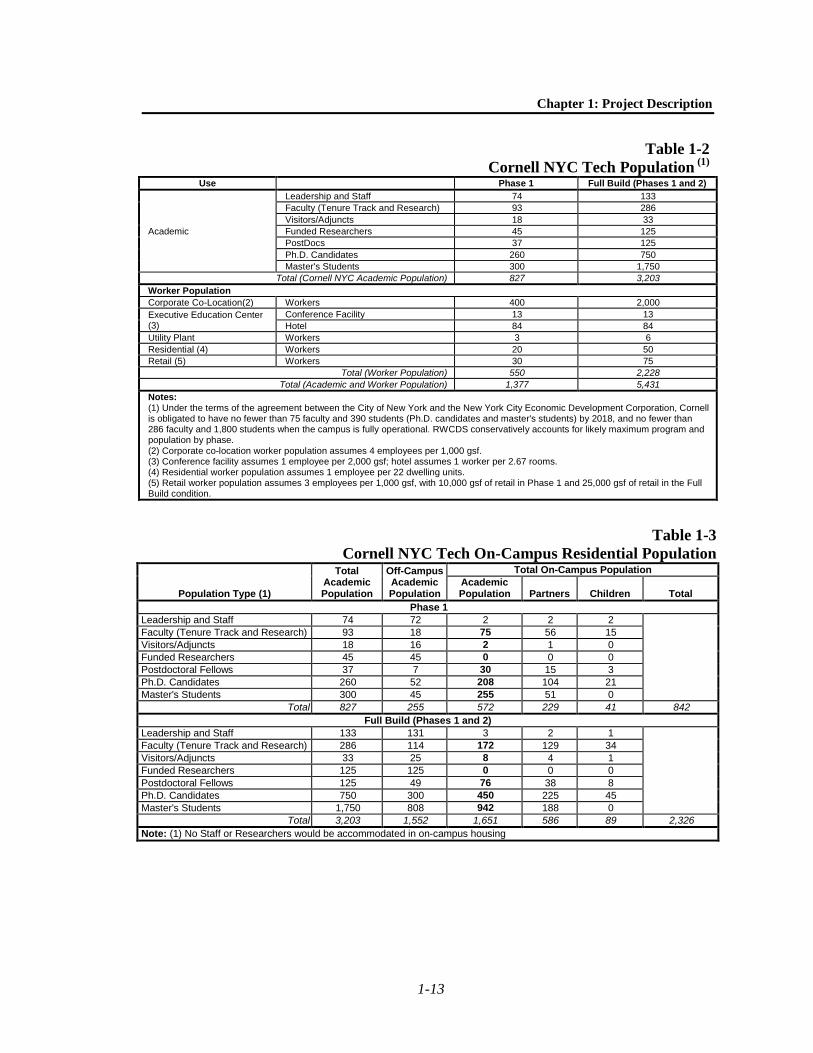
The anticipated Reasonable Worst Case Development Scenario (RWCDS) project population by phase is shown below in Table 1-2. Table 1-2 represents the number of faculty, staff, students, and others who would be generated due to the new academic programs as well as the number of workers that would be introduced by the corporate co-location programs, the Executive Education Center, and the other uses at the campus. Table 1-3 shows the anticipated population that would be housed on the project site and also includes an estimate of the on-site population’s dependents and families. As housing at the Cornell NYC Tech campus would be open only to Cornell University affiliates and not the general population, the standard demographic assumptions used for Manhattan would not apply to this project. In order to estimate on-campus population at Cornell NYC Tech, Cornell has based its projections on housing patterns at Weill Cornell Medical College in Manhattan and the College of Engineering and applied sciences departments at its Ithaca campus.
G. ANALYSIS FRAMEWORK The proposed actions would change the regulatory controls governing land use and development on the project site and would allow its development over the long term. This EIS analyzes the proposed actions’ potential to result in significant adverse environmental impacts. As necessary, the EIS considers alternatives that would reduce or eliminate impacts identified in the technical analyses and proposes mitigation for such impacts, to the extent practicable mitigation exists.
The approach to the EIS analysis is discussed below.
ANALYSIS APPROACH
Each chapter of the EIS assesses whether development resulting from the proposed actions could result in significant adverse environmental impacts.
6 Solid waste on Roosevelt Island is collected by an automated vacuum collection (AVAC) system, except for the
Goldwater and Coler Hospitals, whose waste is handled by DSNY. Waste collected by AVAC is transported through pneumatic tubes to a central facility where it is compacted and collected by DSNY trucks. Operation of the AVAC system is the responsibility of RIOC. Cornell does not intend to connect to the AVAC system.
Chapter 1: Project Description
1-13
Table 1-2 Cornell NYC Tech Population (1)
Use Phase 1 Full Build (Phases 1 and 2)
Academic
Leadership and Staff 74 133 Faculty (Tenure Track and Research) 93 286 Visitors/Adjuncts 18 33 Funded Researchers 45 125 PostDocs 37 125 Ph.D. Candidates 260 750 Master's Students 300 1,750
Total (Cornell NYC Academic Population) 827 3,203 Worker Population Corporate Co-Location(2) Workers 400 2,000 Executive Education Center (3)
Conference Facility 13 13 Hotel 84 84
Utility Plant Workers 3 6 Residential (4) Workers 20 50 Retail (5) Workers 30 75
Total (Worker Population) 550 2,228 Total (Academic and Worker Population) 1,377 5,431
Notes: (1) Under the terms of the agreement between the City of New York and the New York City Economic Development Corporation, Cornell is obligated to have no fewer than 75 faculty and 390 students (Ph.D. candidates and master's students) by 2018, and no fewer than 286 faculty and 1,800 students when the campus is fully operational. RWCDS conservatively accounts for likely maximum program and population by phase. (2) Corporate co-location worker population assumes 4 employees per 1,000 gsf. (3) Conference facility assumes 1 employee per 2,000 gsf; hotel assumes 1 worker per 2.67 rooms. (4) Residential worker population assumes 1 employee per 22 dwelling units. (5) Retail worker population assumes 3 employees per 1,000 gsf, with 10,000 gsf of retail in Phase 1 and 25,000 gsf of retail in the Full Build condition.
Table 1-3 Cornell NYC Tech On-Campus Residential Population
Population Type (1)
Total Academic Population
Off-Campus Academic Population
Total On-Campus Population Academic Population Partners Children Total
Phase 1 Leadership and Staff 74 72 2 2 2
Faculty (Tenure Track and Research) 93 18 75 56 15 Visitors/Adjuncts 18 16 2 1 0 Funded Researchers 45 45 0 0 0 Postdoctoral Fellows 37 7 30 15 3 Ph.D. Candidates 260 52 208 104 21 Master's Students 300 45 255 51 0
Total 827 255 572 229 41 842 Full Build (Phases 1 and 2)
Leadership and Staff 133 131 3 2 1
Faculty (Tenure Track and Research) 286 114 172 129 34 Visitors/Adjuncts 33 25 8 4 1 Funded Researchers 125 125 0 0 0 Postdoctoral Fellows 125 49 76 38 8 Ph.D. Candidates 750 300 450 225 45 Master's Students 1,750 808 942 188 0
Total 3,203 1,552 1,651 586 89 2,326 Note: (1) No Staff or Researchers would be accommodated in on-campus housing

Cornell NYC Tech DEIS
1-14
In disclosing impacts, the EIS considers a proposed project’s potential adverse impacts on the environmental setting. Because the proposed project would be operational in future years,7 its environmental setting is not the current environment, but the future environment. Therefore, the technical analyses and consideration of alternatives first assess current conditions and then forecast these conditions to 2018 and 2038, corresponding to the completion of Phases 1 and 2, respectively, for the purposes of determining potential impacts. The EIS provides a description of “Existing Conditions” for the year 2012 and assessments of future conditions without the proposed project in both 2018 and 2038 (the “Future without the Proposed Project” or “No-Action” condition) and the future with the proposed project (or “With Action” condition). To forecast the No-Action condition, information on known land-use proposals and, as appropriate, changes in anticipated overall growth, are incorporated. The differences between the Future Without and With the Proposed Project are assessed for whether such differences are adverse and/or significant; any significant adverse environmental impacts are disclosed. The EIS also identifies and analyzes appropriate mitigation for any identified significant adverse environmental impacts.
While the buildings at Goldwater Hospital would most likely be demolished and replaced with another appropriate use if the Cornell NYC Tech project did not proceed, for purposes of conservatively assessing impacts, the EIS accounts for a No-Action condition in which Goldwater Hospital would remain vacant, but the buildings would remain in place. The EIS accounts for the hospital’s demolition and redevelopment of the project site as part of the proposed project.
As discussed above, the proposed project, as described in Section D, “Proposed Development Program,” is the RWCDS for environmental review purposes.
ENVIRONMENTAL REVIEW PROCESS
CITY ENVIRONMENTAL QUALITY REVIEW
All state, county, and local government agencies in New York, except the State Legislature and the courts, must comply with SEQRA. Pursuant to SEQRA and its implementing regulations, New York City has established rules for its own process: City Environmental Quality Review (CEQR). The environmental review process provides a means for decision-makers to systematically consider environmental effects along with other aspects of project planning and design, to propose reasonable alternatives, and to identify, and when practicable, mitigate significant adverse environmental effects. The process also facilitates public involvement in the process by providing the opportunity for public comment on the Draft EIS. The environmental review process is outlined below.
• Establishing a Lead Agency. Under CEQR, the “lead agency” is the public entity responsible for conducting the environmental review. Usually, the lead agency is also the entity primarily responsible for carrying out, funding, or approving a proposed action. For the Cornell NYC Tech project, the lead agency is the New York City Office of the Deputy Mayor for Economic Development.
7 As discussed above, Cornell is obligated to complete construction of Phase 1 by 2017 and Phase 2 by 2037. The
DEIS uses 2018 and 2038 as the analysis years, as those represent the first full years of operation for Phase 1 and Phase 2.

Chapter 1: Project Description
1-15
• Determination of Significance. The lead agency’s first charge is to determine whether a proposed action might have a significant adverse impact on the environment. To make this determination, the lead agency prepared an Environmental Assessment Statement (EAS). Based on the information contained in the EAS, the lead agency determined that the proposed development plan could have the potential to result in significant adverse environmental impacts and issued a Positive Declaration on April 18, 2012, initiating the preparation of an EIS.
• Scoping. “Scoping,” or creating the scope of work, focuses the environmental impact analyses on the key issues to be studied. In addition to the Positive Declaration, the lead agency issued a draft Scope of Work for the EIS on April 18, 2012. This was made available to government agencies, elected officials, and Manhattan Community Board 8 and Queens Community Boards 1 and 2. The document was also made available for review by the public on the lead agency’s website and on the New York City Economic Development Corporation’s website. A public scoping meeting was held on May 22, 2012, at the Manhattan Park Community Center at 8 River Road, Roosevelt Island, New York. Written and emailed comments were accepted through June 8, 2012, and a final Scope of Work, reflecting comments made during scoping, was issued on October 5, 2012.
• Draft Environmental Impact Statement (DEIS). The DEIS, prepared in accordance with the final Scope of Work, is a comprehensive document that systematically considers the expected environmental impacts of a proposed action, evaluates reasonable alternatives, and identifies feasible mitigation measures that, to the maximum extent practicable, address the significant adverse environmental impacts of the proposed action. The lead agency reviewed all aspects of the DEIS to determine its adequacy and adherence to the work effort outlined in the final Scope of Work. Once the lead agency was satisfied that the DEIS was complete for the purposes of public review and comment, it issued a Notice of Completion and circulated the DEIS for review among government agencies and the general public. Circulation of the DEIS marks the beginning of a public review period, during which time a public hearing will be held to solicit comments on the DEIS.
• Public Review. Publication of the DEIS and issuance of the Notice of Completion signal the beginning of the public review period. During this time, which must extend for a minimum of 30 days, the public may review and comment on the DEIS, either in writing or at a public hearing convened for the purpose of receiving such comments. When the CEQR process is coordinated with another city process that requires a public hearing, such as Uniform Land Use Review Procedure, the hearings may be held jointly. The lead agency must publish a notice of the hearing at least 14 days before it takes place and must accept written comments for at least 10 days following the close of the hearing. All substantive comments received on the DEIS, at the hearing, or during the comment period become part of the CEQR record and will be summarized and responded to in the Final EIS (FEIS).
• Final Environmental Impact Statement (FEIS). Once the public comment period for the DEIS closes, the lead agency will prepare the FEIS. This document will include a summary of, and response to, each substantive comment made about the DEIS. Once the lead agency determines that the FEIS is complete, it will issue a Notice of Completion and circulate the FEIS.
• Statement of Findings. To demonstrate that the responsible public decision-maker has taken a hard look at the environmental consequences of a proposed action, each public agency taking a discretionary action regarding an action must adopt a formal set of written

Cornell NYC Tech DEIS
1-16
findings, reflecting its conclusions about the significant adverse environmental impacts, potential alternatives, and potential mitigation measures. The findings may not be adopted until 10 days after the Notice of Completion has been issued for the FEIS. Once each agency’s findings are adopted, it may take its actions (or take “no action”).
COORDINATION WITH OTHER REVIEW PROCESSES
The CEQR environmental process is intended to provide decision-makers with an understanding of the environmental consequences of actions undertaken by an agency. Often, the environmental review process is integrated and coordinated with other decision-making processes utilized by government agencies.
Section 14.09 of the New York State Historic Preservation Act of 1980 Because RIOC, which is a State agency, is an involved agency and would have to approve a modification of its lease with the city, the Cornell NYC Tech project is being reviewed in accordance with Section 14.09 of the New York State Historic Preservation Act of 1980 (SHPA), which requires that state agencies consult with the State Historic Preservation Officer to consider the impacts of their actions on historic properties.
Uniform Land Use Review Procedure (ULURP) For the Cornell NYC Tech project, the environmental review under CEQR is being conducted in coordination with public review under the city’s Uniform Land Use Review Procedure (ULURP). The city’s ULURP, mandated by Sections 197-c and 197-d of the City Charter, requires the City Planning Commission (CPC) to review applications affecting the land use of the city. ULURP is a standardized procedure for the review of applications affecting land use by the CPC and the public.
Summary of Actions Subject To ULURP Sections 197-c and 197-d of the City Charter set forth the specific land use actions by the CPC are subject to ULURP. For the Cornell NYC Tech project, the following proposed actions described earlier in this chapter (see Section C, “Proposed Actions”) are subject to ULURP:
• Disposition of Land: consisting of the disposition of City-owned property (by lease with a purchase option) from the City of New York to NYCLDC, which will assign the lease to Cornell
• Zoning Map Amendments: including rezoning the project site and surrounding area from R7-2 to C4-5 and establishing the Special Southern Roosevelt Island District on the rezoning area.
• Changes to the City Map: including the mapping of the one-way loop road surrounding the project site as a city street.
The zoning text amendment to establish the new Special Southern Roosevelt Island District is not subject to ULURP but it is subject to the same public review process. Applications for zoning text amendments are not subject to the ULURP time period, allowing them as much time as necessary for public review. In addition, the other potential public actions required by the project (amendment of the NYCHHC operation agreement with the city; Mayoral approval of the lease and sale terms of the disposition parcels; and RIOC approval of a modification of its lease with the city) are not subject to ULURP. Cornell and NYCEDC are co-applicants for the city map amendment, zoning map amendment, and zoning text amendments; NYCEDC and DCAS are co-applicants for the disposition.
Chapter 1: Project Description
1-17
Public Review Under ULURP ULURP is a process specially designed to allow public review of a proposed action at four levels: the Community Board, the Borough President, and (if applicable) Borough Board, the City Planning Commission, and the City Council. The procedure sets time limits for review at each stage to ensure a maximum total review period of approximately seven months. For a zoning text amendment, a non-ULURP public review process does not have any time limits associated with it. However, it is expected that the non-ULURP text amendment would move through this process concurrently with the ULURP zoning map amendment.
The ULURP process begins with a certification by CPC that the ULURP application is complete. If the particular application is subject to environmental review (see above), a negative declaration, conditional negative declaration, or a notice of completion of a Draft Environmental Impact Statement must be issued before an application can be certified.
The application is then forwarded to the Community Board (Manhattan Community Board 8 for the proposed project), which has 60 days in which to review and discuss the proposal, hold public hearings, and adopt recommendations regarding the application. Once this step is complete, the Borough President reviews the application for up to 30 days.
CPC must hold a public hearing and approve, approve with modifications, or disapprove the application within 60 days of the expiration of the Borough President’s review period. For projects for which a Draft EIS has been prepared, the public hearing is a joint ULURP/CEQR public hearing (the record for commenting remains open for 10 days after the hearing to receive written comments). Comments made at the DEIS public hearing are incorporated into an FEIS; the FEIS must be completed at least 10 days before CPC makes its decision on the application. CPC may approve, approve with modifications, or deny the application.
The next step in the ULURP process is review by the City Council. The City Council does not automatically review all ULURP actions that are approved by CPC. Zoning map changes and zoning text changes (not subject to ULURP) must be reviewed by City Council; the Council may elect to review certain other actions. The City Council has 50 days to review the application and during this time must hold a public hearing on the action and approve, approve with modifications, or deny the application. If the Council proposes a modification to the proposed action, the ULURP review process stops for 15 days, providing time for a CPC determination on whether the modification is within the scope of the environmental review and ULURP review. If it is, then the Council may proceed with the modification; if not, then the Council may only vote on the action as approved by CPC. Following the Council’s vote, the Mayor has 5 days in which to veto the Council’s action. The City Council may override the mayoral veto within 10 days.