Embed Size (px)
Citation preview
CHAPTER 1: INTRODUCTION
City of Soledad Downtown Specific Plan | City Council Draft 8.31.12 | 1-1
1.1 PURPOSEUnder California law, a specific plan is a planning tool that allows a City to define a vision for a specific area and apply guidelines and regulations for implementation. It can establish clear policies, implementation strategies, and design standards to guide public and private investment in a coordinated manner.
The Soledad Downtown Specific Plan (Plan) provides direction for the City’s historic downtown and adjacent residential areas. It is intended to guide initiatives that capitalize on the City’s unique assets with the overarching goal of revitalizing downtown. The Plan is designed to bring new life to the City’s historic Front Street corridor by encouraging commercial and entertainment uses that will draw locals and visitors, and reducing development obstacles, such as environmental review, parking, and permit processing.
The Plan aims to implement the Downtown Vision Program and the 2005 General Plan.
1.2 HOW TO USE THE PLANThis Plan is divided into five chapters. Chapters 1 though 3 are provide details regarding the overall vision of the Plan Area and analyses of existing conditions. Chapter 4 (Implementation) contains policies and actions to serve as a guide for bringing to life the vision for the Plan Area. Chapter 5 (Development Code) is regulatory and controls new development and redevelopment in the Plan Area. More information on the contents of each chapter of this Plan can be found in Section 1.8 (Plan Organization).
1.3 PLAN AREAThe City of Soledad is located in Monterey County, approximately 25 miles south of Salinas along U.S. Highway 101. Other nearby cities include Gonzales (10 miles), Greenfield (nine miles) and King City (20 miles). The Plan Area encompasses all of downtown Soledad and is bounded roughly by U.S. Highway 101 to the west, North Street to the east, San Vicente Road to the north, and Nestles Road to the south, and comprises nearly 200 total acres.
1. INTRODUCTION
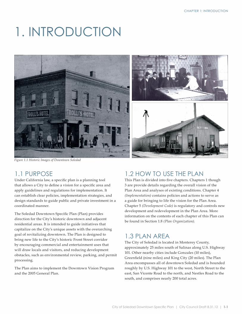
Figure 1.1 Historic Images of Downtown Soledad
CHAPTER 1: INTRODUCTION
1-2 | City Council Draft 8.31.12 | City of Soledad Downtown Specific Plan
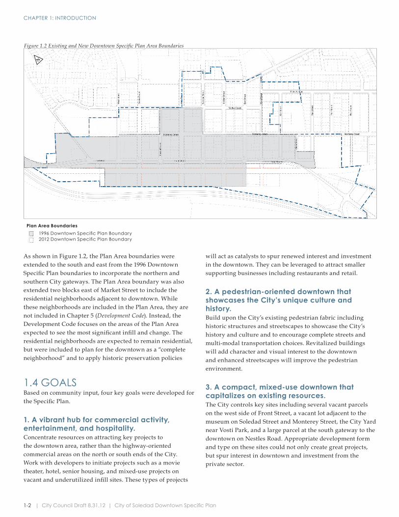
As shown in Figure 1.2, the Plan Area boundaries were extended to the south and east from the 1996 Downtown Specific Plan boundaries to incorporate the northern and southern City gateways. The Plan Area boundary was also extended two blocks east of Market Street to include the residential neighborhoods adjacent to downtown. While these neighborhoods are included in the Plan Area, they are not included in Chapter 5 (Development Code). Instead, the Development Code focuses on the areas of the Plan Area expected to see the most significant infill and change. The residential neighborhoods are expected to remain residential, but were included to plan for the downtown as a “complete neighborhood” and to apply historic preservation policies
1.4 GOALSBased on community input, four key goals were developed for the Specific Plan.
1. A vibrant hub for commercial activity, entertainment, and hospitality. Concentrate resources on attracting key projects to the downtown area, rather than the highway-oriented commercial areas on the north or south ends of the City. Work with developers to initiate projects such as a movie theater, hotel, senior housing, and mixed-use projects on vacant and underutilized infill sites. These types of projects
will act as catalysts to spur renewed interest and investment in the downtown. They can be leveraged to attract smaller supporting businesses including restaurants and retail.
2. A pedestrian-oriented downtown that showcases the City’s unique culture and history. Build upon the City’s existing pedestrian fabric including historic structures and streetscapes to showcase the City’s history and culture and to encourage complete streets and multi-modal transportation choices. Revitalized buildings will add character and visual interest to the downtown and enhanced streetscapes will improve the pedestrian environment.
3. A compact, mixed-use downtown that capitalizes on existing resources. The City controls key sites including several vacant parcels on the west side of Front Street, a vacant lot adjacent to the museum on Soledad Street and Monterey Street, the City Yard near Vosti Park, and a large parcel at the south gateway to the downtown on Nestles Road. Appropriate development form and type on these sites could not only create great projects, but spur interest in downtown and investment from the private sector.
Figure 1.2 Existing and New Downtown Specific Plan Area Boundaries
Plan Area Boundaries1996 Downtown Specific Plan Boundary2012 Downtown Specific Plan Boundary
N
CHAPTER 1: INTRODUCTION
City of Soledad Downtown Specific Plan | City Council Draft 8.31.12 | 1-3
In the 2008 Regional Forecast, the Association of Monterey Bay Area Governments (AMBAG) predicted continued growth in Soledad and throughout Monterey County through 2035. AMBAG estimated a total population of 33,760 by 2020 and 41,405 by 2035 for the City. Assuming a prison population comparable to the average number of inmates from 1990 to 2010, the adjusted non-prison AMBAG population estimates would be 22,814 by 2020 and 30,459 by 2035.
As of 2010, Soledad represented approximately six percent of the population of Monterey County, including the inmate population.
Household TrendsAccording to the U.S. Census, the estimated average household in Soledad contained 4.27 persons as of 2010. The 2010 Soledad household size was lower among owner-occupied units, with an average of 4.13 persons per household, while the average in renter-occupied units was 4.45.
The Soledad housing stock consisted of 3,876 units as of 2010 (U.S. Census). This represents an increase of 53 percent since 2000. According to estimates, the majority of new units constructed were single-family homes, which increased from 1,681 units in 2000 to 2,870 units in 2010, an increase of 71 percent. As of 2010, single-family homes represented approximately 72 percent of the City’s housing stock. There was also a significant increase in multi-family units of five or more, which increased over 120 percent from 210 units in 2000 to 469 units in 2010.
As of 2010, approximately 95 percent of Soledad housing units were occupied. The occupancy rate is slightly down from 2000 when 98 percent of units were occupied. The 2010 occupancy rate in Soledad was higher than that of nearby Greenfield and King City which had rates of 92 percent and 93 percent respectively, but slightly less than Gonzales, which had an occupancy rate of 96 percent. Among occupied housing units, 57 percent were owner-occupied as of 2010. This represents a decrease from 2000 when 62 percent of occupied units were inhabited by the owner.
Income TrendsAs of 2009, the City median household income was $57,132 (U.S. Census, American Community Survey). This was slightly lower than the Monterey County median at $59,111 and the California median at $60,422.
Approximately 44 percent of Soledad households had an annual income of less than $50,000. This is comparable to the total percentage of Monterey County households at 42 percent.
In addition to specific lots, the City controls ample land in the form of wide streets. At minimal expense, existing paved street space can be repurposed for parking as greater downtown activity results in increased parking demand. In some cases, additional pedestrian amenities such as wider sidewalks or additional landscaping may be appropriate.
4. A memorable place.Building design, streetscape treatments, public spaces, and unique elements such as gateway markers and public art should contribute to a unique and memorable downtown experience for both residents and visitors. The objectives listed in Chapter 2 ( Vision and Downtown Character) articulate concepts that aim to create this type of experience. For example, a public plaza and train depot will welcome visitors and clearly mark the center of the City. The flower fields proposed on the vacant parcels between U.S. Highway 101 and the railroad tracks will be a differentiating element for downtown users and highway motorists. The bright lights of the depicted movie theater marquee could serve as a downtown landmark. Properly oriented gateway development, streetscaping, and a pronounced community center will contribute to a significantly improved visitor experience from the southern U.S. Highway 101 interchange and help to draw visitors downtown. As these changes are integrated and constructed over time, the City will take on a more distinctive feel and personality, making it an attractive place for residents or those travelling through the area.
1.5 OVERVIEW OF EXISTING CONDITIONSDEMOGRAPHICS
PopulationThe City population was estimated at 25,738 as of 2010 (U.S. Census, 2010). Among the total population, 10,143 persons were institutionalized (U.S. Census, 2010), most of whom were inmates at the Correctional Training Facility and Salinas Valley State Prison, leaving a total household population of 15,595.
The Soledad population has grown significantly over the past 20 years. From 1990 to 2010, the population increased approximately 118 percent (excluding the prison inmate population), with an average annual growth rate of six percent. However, the City’s population is estimated to have decreased slightly between 2005 and 2010.
Nearby Greenfield grew at a pace similar to Soledad, and King City and Gonzales experienced rapid growth from 1990 to 2000 but the pace of growth in Gonzales slowed slightly over the past 10 years while the population in King City increased.
CHAPTER 1: INTRODUCTION
1-4 | City Council Draft 8.31.12 | City of Soledad Downtown Specific Plan
EmploymentAgriculture is the largest employment sector for Soledad residents. The industry employed 2,091 residents as of 2009, approximately 35 percent of the working population. Educational services, health care, and social assistance is the second largest employment industry, followed by public administration.
A high percentage of residents commute out of the City for work every day. According to the U.S. Census, the mean travel time to work was 25 minutes for Soledad residents (U.S. Census, American Community Survey, 2009).
1.6 PLAN PREPARATION AND PUBLIC PARTICIPATIONThe Downtown Specific Plan was developed through research of existing plan documents, as well as a thorough public engagement process. The public engagement process involved stakeholder interviews, a three-day design charrette, a joint City Council and Planning Commission meeting, and an economic forum. Results from this process shaped the vision, goals, policies, and development code included in this Plan. The public engagement process is discussed in greater detail in Appendix C.
PUBLIC ENGAGEMENT PROCESS
Stakeholder InterviewsThe Consultant Team conducted personal interviews with 25 community members on March 1, 2011. Each interview ranged from 30 to 45 minutes. The interviews were comprised of general, open-ended questions intended to gather specific data as well as invite conversation, enabling the Consultant Team to gather more extensive responses than may have otherwise been captured.
Interviewees included public officials, downtown property owners, and representatives of business organizations. Interviewees were invited to participate based on the recommendations of the Community and Economic Development Department.
The results of these interviews were summarized , discussed at the design charrette, and incorporated into the Plan, as appropriate.
Design CharretteA three-day (May 2, 2011, to May 4, 2011) design charrette was held at the Soledad Business Center in the Lum Building on 749 Front Street to enable the community to direct the long-term visioning process.
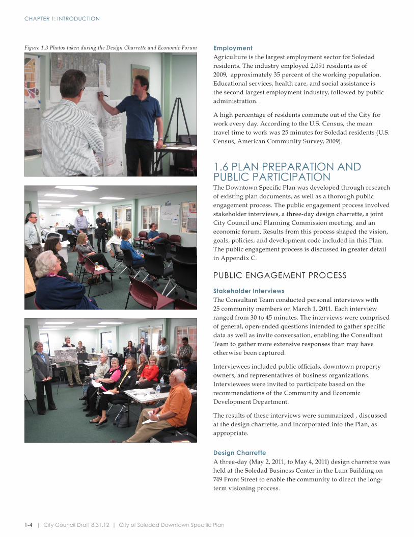
Figure 1.3 Photos taken during the Design Charrette and Economic Forum
CHAPTER 1: INTRODUCTION
City of Soledad Downtown Specific Plan | City Council Draft 8.31.12 | 1-5
PREVIOUS PLAN DOCUMENTSThe following documents were reviewed and referenced throughout the preparation of the Downtown Specific Plan. See Appendix C for an overview of the documents:
• 1996 Downtown Specific Plan
• 2005 General Plan and EIR
• Municipal Code
• 2010 Community Design Guidelines and Standards
• Economic Development Strategy
1.7 AUTHORITYThe Downtown Soledad Specific Plan is enacted pursuant to Government Code Section 65450 by resolution, and the Development Code (Chapter 5) by ordinance, to apply to all property within the Plan area.
1.8 PLAN ORGANIZATIONThe Plan is organized into five chapters: Chapter 2 (Vision and Downtown Character), Chapter 3 (Mobility and Infrastructure), Chapter 4 (Implementation), and Chapter 5 (Development Code).
CHAPTER 2. VISION AND DOWNTOWN CHARACTERChapter 2 illustrates how Soledad’s historic downtown could transform over the next 25 years. It includes a development program describing the build-out potential for the Plan Area and provides an overview of the vision and overall design for key sub areas.
CHAPTER 3. MOBILITY AND INFRASTRUCTUREChapter 3 addresses mobility and parking in the Plan Area. It provides guiding principles for street design, addresses pedestrian facilities and safety, and includes standards for bikeways as well as a discussion on public transit. The Chapter also includes a number of parking strategies that may play a key role in the successful implementation of larger-scale catalyst projects proposed in the Vision.
This Chapter also addresses utilities and infrastructure through a discussion of public facilities and schools, water and wastewater, and energy. It includes an analysis of existing supply and lists improvements necessary to meet the potential increase in demand that may be caused if the Specific Plan build-out is met.
The charrette kicked off with a brown bag lunch presentation on Monday regarding urban design and circulation. The studio was held open Monday and Tuesday evenings for the public to view preliminary drawings and discuss ideas and concerns with the Consultant Team.
The Team gave another lunchtime presentation on Tuesday to discuss economic development strategies for downtown. The Consultant Team also had the opportunity to meet with a number of City Staff members during the charrette including the City Manager, Director of Community Development, Director of Public Works, Fire Chief, as well as the City Council, Planning Commission, and several downtown property and business owners.
The charrette culminated in a presentation at a joint Planning Commission and City Council workshop at City Hall on Wednesday. The Consultant Team summarized ideas generated throughout the visioning process and presented a concept for the future of Downtown Soledad. The final Vision Program presented to the Planning Commission and City Council is the basis for all goals, guidelines and standards presented in this Plan.
City Council and Planning Commission Joint MeetingA joint City Council and Planning Commission meeting was held on August 3, 2011, to summarize the work completed to date and to confirm the downtown Vision Program before the Consultant Team prepared additional analysis and illustrations, draft policies, implementation actions, and the development code. The City Council and Planning Commission were in favor of the Vision Program Recommendations and agreed to move forward with the Plan.
Economic ForumAn economic forum was held on October 19, 2011 at the Soledad Business Center. Over twenty participants attended the forum. Attendees included representatives from the Soledad Mission Chamber of Commerce, the Planning Commission, Santa Barbara Bank and Trust, the Soledad Historical Society and Museum, a local ADA representative, local independent business owners, and land owners, among others.
Forum participants discussed current economic issues in Soledad, with a particular focus on the shortage of viable retail outlets in the downtown area. The Consultant Team left with several community-driven economic goals for building a stronger downtown.
CHAPTER 1: INTRODUCTION
1-6 | City Council Draft 8.31.12 | City of Soledad Downtown Specific Plan
CHAPTER 4. IMPLEMENTATION The Implementation Chapter organizes the ideas set forth in the rest of the Specific Plan into a series of phased actions. It also lists sources for funding the Plan’s proposed projects and provides financing strategies.
CHAPTER 5. DEVELOPMENT CODEThe Development Code provides the building standards and uses that will ensure new development is consistent with the Plan’s vision. It includes a regulating plan of the Plan Area’s new districts, and provides regulations for land use, building design, frontages, signs, parking, and streets and streetscapes. The Development Code also includes procedures, standards for specific uses, general standards, and definitions.