Embed Size (px)
Citation preview

Chapter 1Introduction
Geophysics, the physics of the Earth, is a huge subject that includes the physicsof space and the atmosphere, of the oceans and of the interior of the planet. Theheart of geophysics, though, is the theory of the solid Earth. We now understandin broad terms how the Earth’s surface operates, and we have some notion ofthe workings of the deep interior. These processes and the means by which theyhave been understood form the theme of this book. To the layperson, geophysicsmeans many practical things. For Californians, it is earthquakes and volcanoes;for Texans and Albertans, it is oil exploration; for Africans, it is groundwaterhydrology. The methods and practices of applied geophysics are not dealt with atlength here because they are covered in many specialized textbooks. This bookis about the Earth, its structure and function from surface to centre.
Our search for an understanding of the planet goes back millennia to theancient Hebrew writer of the Book of Job and to the Egyptians, Babylonians andChinese. The Greeks first measured the Earth, Galileo and Newton put it in itsplace, but the Victorians began the modern discipline of geophysics. They andtheir successors were concerned chiefly with understanding the structure of theEarth, and they were remarkably successful. The results are summarized in themagnificent book The Earth by Sir Harold Jeffreys, which was first published in1924. Since the Second World War the function of the Earth’s surface has beenthe focus of attention, especially since 1967 when geophysics was revolutionizedby the discovery of plate tectonics, the theory that explains the function of theuppermost layers of the planet.
The rocks exposed at the surface of the Earth are part of the crust (Fig. 1.1).This crustal layer, which is rich in silica, was identified by John Milne (1906),Lord Rayleigh and Lord Rutherford (1907). It is on average 38 km thick beneathcontinents and 7–8 km thick beneath oceans. Beneath this thin crust lies themantle, which extends down some 2900 km to the Earth’s central core. The man-tle (originally termed Mantel or ‘coat’ in German by Emil Wiechert in 1897,perhaps by analogy with Psalm 104) is both physically and chemically distinctfrom the crust, being rich in magnesium silicates. The crust has been derivedfrom the mantle over the aeons by a series of melting and reworking processes.The boundary between the crust and mantle, which was delineated by Andrya
1
© Cambridge University Press www.cambridge.org
Cambridge University Press0521584094 - The Solid Earth: An Introduction to Global Geophysics, Second EditionC. M. R. FowlerExcerptMore information

2 Introduction
Upper
CRUST
MANTLE
OUTERCORE
INNERCORE
solid
liquid
solid
Lower
Lithosphere
Transitionzone
D′′ layer
Fe withNi, O, S
impurities
Fe
(Mg, Fe)silicate
Figure 1.1. The majorinternal divisions of theEarth.
Mohorovicic in 1909, is termed the Mohorovicic discontinuity, or Moho for short.The core of the Earth was discovered by R. D. Oldham in 1906 and correctly delin-eated by Beno Gutenberg in 1912 from studies of earthquake data (Gutenberg1913, 1914). The core is totally different, both physically and chemically, fromthe crust and mantle. It is predominantly iron with lesser amounts of other ele-ments. The core was established as being fluid in 1926 as the result of work ontides by Sir Harold Jeffreys. In 1929 a large earthquake occurred near Buller inthe South Island of New Zealand. This, being conveniently on the other side of theEarth from Europe, enabled Inge Lehmann, a Danish seismologist, to studythe energy that had passed through the core. In 1936, on the basis of data fromthis earthquake, she was able to show that the Earth has an inner core within theliquid outer core. The inner core is solid.
The presence of ancient beaches and fossils of sea creatures in mountainsthousands of feet above sea level was a puzzle and a stimulation to geologistsfrom Pliny’s time to the days of Leonardo and Hutton. On 20 February 1835, theyoung Charles Darwin was on shore resting in a wood near Valdivia, Chile, whensuddenly the ground shook. In his journal The Voyage of the Beagle Darwin (1845)wrote that ‘The earth, the very emblem of solidity, has moved beneath our feet
© Cambridge University Press www.cambridge.org
Cambridge University Press0521584094 - The Solid Earth: An Introduction to Global Geophysics, Second EditionC. M. R. FowlerExcerptMore information

References and bibliography 3
like a thin crust over a fluid.’ This was the great Concepcion earthquake. Severaldays later, near Concepcion, Darwin reported that ‘Captain Fitz Roy found bedsof putrid mussel shells still adhering to the rocks, ten feet above high water level:the inhabitants had formerly dived at low-water spring-tides for these shells.’ Thevolcanoes erupted. The solid Earth was active.
By the early twentieth century scientific opinion was that the Earth had cooledfrom its presumed original molten state and the contraction which resulted fromthis cooling caused surface topography: the mountain ranges and the ocean basins.The well-established fact that many fossils, animals and plants found on separatedcontinents must have had a common source was explained by either the sinkingof huge continental areas to form the oceans (which is, and was then recognizedto be, impossible) or the sinking beneath the oceans of land bridges that wouldhave enabled the animals and plants to move from continent to continent.
In 1915 the German meteorologist Alfred Wegener published a proposal thatthe continents had slowly moved about. This theory of continental drift, whichaccounted for the complementarity of the shapes of coastlines on opposite sidesof oceans and for the palaeontological, zoological and botanical evidence, wasaccepted by some geologists, particularly those from the southern hemispheresuch as Alex Du Toit (1937), but was generally not well received. Geophysicistsquite correctly pointed out that it was physically impossible to move the con-tinents through the solid rock which comprised the ocean floor. By the 1950s,however, work on the magnetism of continental rocks indicated that in the pastthe continents must have moved relative to each other; the mid-ocean ridges,the Earth’s longest system of mountains, had been discovered, and continentaldrift was again under discussion. In 1962 the American geologist Harry H. Hesspublished an important paper on the workings of the Earth. He proposed thatcontinental drift had occurred by the process of seafloor spreading. The mid-ocean ridges marked the limbs of rising convection cells in the mantle. Thus, asthe continents moved apart, new seafloor material rose from the mantle along themid-ocean ridges to fill the vacant space. In the following decade the theory ofplate tectonics, which was able to account successfully for the physical, geologicaland biological observations, was developed. This theory has become the unifyingfactor in the study of geology and geophysics. The main difference between platetectonics and the early proposals of continental drift is that the continents are nolonger thought of as ploughing through the oceanic rocks; instead, the oceanicrocks and the continents are together moving over the interior of the Earth.
References and bibliography
Brush, S. J. 1980. Discovery of the earth’s core. Am. J. Phys., 48, 705–24.
Darwin, C. R. 1845. Journal of Researches into the Natural History and Geology of the
Countries Visited during the Voyage of H.M.S. Beagle round the World, under the
Command of Capt. Fitz Roy R.N., 2nd edn. London: John Murray.
© Cambridge University Press www.cambridge.org
Cambridge University Press0521584094 - The Solid Earth: An Introduction to Global Geophysics, Second EditionC. M. R. FowlerExcerptMore information

4 Introduction
Du Toit, A. 1937. Our Wandering Continents. Edinburgh: Oliver and Boyd.
Gutenberg, B. 1913. Uber die Konstitution der Erdinnern, erschlossen aus
Erdbebenbeobachtungen. Phys. Zeit., 14, 1217.
1914. Uber Erdbebenwellen, VIIA. Beobachtungen an Registrierungen von Fernbeben in
Gottingen und Folgerungen uber die Konstitution des Erdkorpers. Nachr. Ges. Wiss.
Gottingen. Math. Phys., Kl. 1, 1–52.
Hess, H. H. 1962. History of ocean basins. In A. E. J. Engel, H. L. James and B. F. Leonard,
eds., Petrologic Studies: A Volume in Honor of A. F. Buddington. Boulder, Colorado:
Geological Society of America, pp. 599–620.
Jeffreys, H. 1926. The rigidity of the Earth’s central core. Mon. Not. Roy. Astron. Soc.
Geophys. Suppl., 1, 371–83. (Reprinted in Jeffreys, H. 1971. Collected Papers, Vol. 1.
New York: Gordon and Breach.)
1976. The Earth, 6th edn. Cambridge: Cambridge University Press.
Lehmann, I. 1936. P′. Trav. Sci., Sect. Seis. U.G.G.I. (Toulouse), 14, 3–31.
Milne, J. 1906. Bakerian Lecture – recent advances in seismology. Proc. Roy. Soc. A, 77,
365–76.
Mohorovicic, A. 1909. Das Beben vom 8. X. 1909. Jahrbuch met. Obs. Zagreb, 9, 1–63.
Oldham, R. D. 1906. The constitution of the earth as revealed by earthquakes. Quart. J. Geol.
Soc., 62, 456–75.
Rutherford, E. 1907. Some cosmical aspects of radioactivity. J. Roy. Astr. Soc. Canada,
May–June, 145–65.
Wegener, A. 1915. Die Entstehung der Kontinente und Ozeane.
1924. The Origin of Continents and Oceans. New York: Dutton.
Wiechert, E. 1897. Uber die Massenvertheilung im Innern der Erde. Nachr. Ges. Wiss.
Gottingen, 221–43.
General books
Anderson, R. N. 1986. Marine Geology: A Planet Earth Perspective. New York: Wiley.
Brown, G. C. and Mussett, A. E. 1993. The Inaccessible Earth, 2nd edn. London: Chapman
and Hall.
Cattermole, P. and Moore, P. 1985. The Story of the Earth. Cambridge: Cambridge University
Press.
Clark, S. P. J. 1971. Structure of the Earth. Englewood Cliffs, New Jersey: Prentice-Hall.
Cloud, P. 1988. Oasis in Space: Earth History from the Beginning. New York: Norton.
Cole, G. H. A. 1986. Inside a Planet. Hull: Hull University Press.
Holmes, A. 1965. Principles of Physical Geology. New York: Ronald Press.
Lowrie, W. 1997. Fundamentals of Geophysics, Cambridge: Cambridge University Press.
van Andel, T. H. 1994. New Views on an Old Planet, Continental Drift and the History of
Earth, 2nd edn. Cambridge: Cambridge University Press.
Wyllie, P. J. 1976. The Way the Earth Works. New York: Wiley.
© Cambridge University Press www.cambridge.org
Cambridge University Press0521584094 - The Solid Earth: An Introduction to Global Geophysics, Second EditionC. M. R. FowlerExcerptMore information

Chapter 2Tectonics on a sphere: the geometryof plate tectonics
2.1 Plate tectonics
The Earth has a cool and therefore mechanically strong outermost shell calledthe lithosphere (Greek lithos, ‘rock’). The lithosphere is of the order of 100 kmthick and comprises the crust and uppermost mantle. It is thinnest in the oceanicregions and thicker in continental regions, where its base is poorly understood.The asthenosphere (Greek asthenia, ‘weak’ or ‘sick’) is that part of the mantleimmediately beneath the lithosphere. The high temperature and pressure whichexist at the depth of the asthenosphere cause its viscosity to be low enough toallow viscous flow to take place on a geological timescale (millions of years, notseconds!). If the Earth is viewed in purely mechanical terms, the mechanicallystrong lithosphere floats on the mechanically weak asthenosphere. Alternatively,if the Earth is viewed as a heat engine, the lithosphere is an outer skin, throughwhich heat is lost by conduction, and the asthenosphere is an interior shell throughwhich heat is transferred by convection (Section 7.1).
The basic concept of plate tectonics is that the lithosphere is divided into asmall number of nearly rigid plates (like curved caps on a sphere), which aremoving over the asthenosphere. Most of the deformation which results from themotion of the plates – such as stretching, folding or shearing – takes place alongthe edge, or boundary, of a plate. Deformation away from the boundary is notsignificant.
A map of the seismicity (earthquake activity) of the Earth (Fig. 2.1) outlines theplates very clearly because nearly all earthquakes, as well as most of the Earth’svolcanism, occur along the plate boundaries. These seismic belts are the zonesin which differential movements between the nearly rigid plates occur. There areseven main plates, of which the largest is the Pacific plate, and numerous smallerplates such as Nazca, Cocos and Scotia plates (Fig. 2.2).
The theory of plate tectonics, which describes the interactions of the litho-spheric plates and the consequences of these interactions, is based on severalimportant assumptions.
5
© Cambridge University Press www.cambridge.org
Cambridge University Press0521584094 - The Solid Earth: An Introduction to Global Geophysics, Second EditionC. M. R. FowlerExcerptMore information

6 Tectonics on a sphere
1. The generation of new plate material occurs by seafloor spreading; that is, new oceanic
lithosphere is generated along the active mid-ocean ridges (see Chapters 3 and 9).
2. The new oceanic lithosphere, once created, forms part of a rigid plate; this plate may
but need not include continental material.
3. The Earth’s surface area remains constant; therefore the generation of new plate by
seafloor spreading must be balanced by destruction of plate elsewhere.
4. The plates are capable of transmitting stresses over great horizontal distances without
buckling, in other words, the relative motion between plates is taken up only along plate
boundaries.
Plate boundaries are of three types.
1. Along divergent boundaries, which are also called accreting or constructive, plates are
moving away from each other. At such boundaries new plate material, derived from
the mantle, is added to the lithosphere. The divergent plate boundary is represented by
the mid-ocean-ridge system, along the axis of which new plate material is produced
(Fig. 2.3(a)).
2. Along convergent boundaries, which are also called consuming or destructive, plates
approach each other. Most such boundaries are represented by the oceanic-trench,
island-arc systems of subduction zones where one of the colliding plates descends
into the mantle and is destroyed (Fig. 2.3(c)). The downgoing plate often penetrates
the mantle to depths of about 700 km. Some convergent boundaries occur on land.
Japan, the Aleutians and the Himalayas are the surface expression of convergent plate
boundaries.
3. Along conservative boundaries, lithosphere is neither created nor destroyed. The plates
move laterally relative to each other (Fig. 2.3(e)). These plate boundaries are represented
by transform faults, of which the San Andreas Fault in California, U.S.A. is a famous
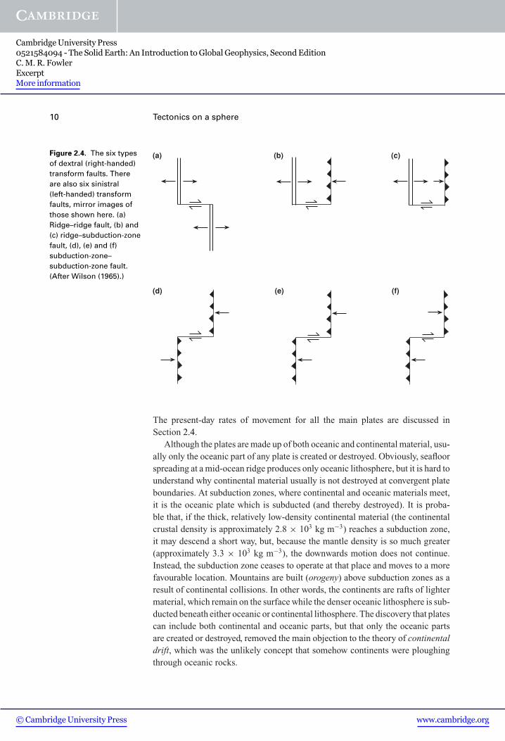
example. Transform faults can be grouped into six basic classes (Fig. 2.4). By far
the most common type of transform fault is the ridge–ridge fault (Fig. 2.4(a)), which
can range from a few kilometres to hundreds of kilometres in length. Some very long
ridge–ridge faults occur in the Pacific, equatorial Atlantic and southern oceans (see
Fig. 2.2, which shows the present plate boundaries, and Table 8.3). Adjacent plates
move relative to each other at rates up to about 15 cm yr−1.
© Cambridge University Press www.cambridge.org
Cambridge University Press0521584094 - The Solid Earth: An Introduction to Global Geophysics, Second EditionC. M. R. FowlerExcerptMore information

2.1 Plate tectonics 7
Fig
ure
2.1
.Tw
enty
-th
ree
tho
usa
nd
eart
hq
uak
esw
ith
mag
nit
ud
esg
reat
erth
an5.
2o
ccu
rred
bet
wee
n19
78an
d19
89at
dep
ths
fro
m0
to70
0km
.Th
ese
eart
hq
uak
escl
earl
yd
elin
eate
the
bo
un
dar
ies
of
the
pla
tes.
(Fro
mIS
Cca
talo
gu
e.)
© Cambridge University Press www.cambridge.org
Cambridge University Press0521584094 - The Solid Earth: An Introduction to Global Geophysics, Second EditionC. M. R. FowlerExcerptMore information

8 Tectonics on a sphere
Fig
ure
2.2
.T
he
maj
or
tect
on
icp
late
s,m
id-o
cean
rid
ges
,tre
nch
esan
dtr
ansf
orm
fau
lts.
© Cambridge University Press www.cambridge.org
Cambridge University Press0521584094 - The Solid Earth: An Introduction to Global Geophysics, Second EditionC. M. R. FowlerExcerptMore information

2.1 Plate tectonics 9
Plate A Plate B
10
Plate A Plate B
6
Plate A Plate B
22
6
4
4
A Bv
BvA
(a)
(b)
(c)(d)
(e)(f)
BvA
A Bv
10
10
BvAA Bv 66
Figure 2.3. Three possible boundaries between plates A and B.(a) A constructive boundary (mid-ocean ridge). The double line is the symbol for
the ridge axis, and the arrows and numbers indicate the direction of spreading andrelative movement of the plates away from the ridge. In this example thehalf-spreading rate of the ridge (half-rate) is 2 cm yr−1; that is, plates A and B aremoving apart at 4 cm yr−1, and each plate is growing at 2 cm yr−1. (b) The relativevelocities AvB and BvA for the ridge shown in (a).
(c) A destructive boundary (subduction zone). The barbed line is the symbol for asubduction zone; the barbs are on the side of the overriding plate, pointing awayfrom the subducting or downgoing plate. The arrow and number indicate thedirection and rate of relative motion between the two plates. In this example, plate Bis being subducted at 10 cm yr−1. (d) The relative velocities AvB and BvA for thesubduction zone shown in (c).
(e) A conservative boundary (transform fault). The single line is a symbol for atransform fault. The half-arrows and number indicate the direction and rate ofrelative motion between the plates: in this example, 6 cm yr−1. (f) The relativevelocities AvB and BvA for the transform fault shown in (e).
© Cambridge University Press www.cambridge.org
Cambridge University Press0521584094 - The Solid Earth: An Introduction to Global Geophysics, Second EditionC. M. R. FowlerExcerptMore information
10 Tectonics on a sphere
(a) (b) (c)
(f)(d) (e)
Figure 2.4. The six typesof dextral (right-handed)transform faults. Thereare also six sinistral(left-handed) transformfaults, mirror images ofthose shown here. (a)Ridge–ridge fault, (b) and(c) ridge–subduction-zonefault, (d), (e) and (f)subduction-zone–subduction-zone fault.(After Wilson (1965).)
The present-day rates of movement for all the main plates are discussed inSection 2.4.
Although the plates are made up of both oceanic and continental material, usu-ally only the oceanic part of any plate is created or destroyed. Obviously, seafloorspreading at a mid-ocean ridge produces only oceanic lithosphere, but it is hard tounderstand why continental material usually is not destroyed at convergent plateboundaries. At subduction zones, where continental and oceanic materials meet,it is the oceanic plate which is subducted (and thereby destroyed). It is proba-ble that, if the thick, relatively low-density continental material (the continentalcrustal density is approximately 2.8 × 10³ kg m−3) reaches a subduction zone,it may descend a short way, but, because the mantle density is so much greater(approximately 3.3 × 10³ kg m−3), the downwards motion does not continue.Instead, the subduction zone ceases to operate at that place and moves to a morefavourable location. Mountains are built (orogeny) above subduction zones as aresult of continental collisions. In other words, the continents are rafts of lightermaterial, which remain on the surface while the denser oceanic lithosphere is sub-ducted beneath either oceanic or continental lithosphere. The discovery that platescan include both continental and oceanic parts, but that only the oceanic partsare created or destroyed, removed the main objection to the theory of continentaldrift, which was the unlikely concept that somehow continents were ploughingthrough oceanic rocks.
© Cambridge University Press www.cambridge.org
Cambridge University Press0521584094 - The Solid Earth: An Introduction to Global Geophysics, Second EditionC. M. R. FowlerExcerptMore information