Embed Size (px)
Citation preview
CHAPTER 2Agency Organizations,
Roles and Responsibilities,and Airspace Committees
Flying safely is an on-going responsibility of the Pilot in Command (PIC). Airspace management is the responsibility of the FAA and designated agencies, such as the DoD. Airspace coordination is the responsibility of multiple agencies including land management organizations. Specific agency missions result in diverse airspace and safety requirements and mitigation of environmental issues. The following provides an overview with which users need to be familiar in order to effectively coordinate airspace amongst multiple agencies.
I. Federal Aviation Administration (FAA)
“The navigable airspace is a limited national resource, the use of which Congress has charged the FAA to administer in the public interest as necessary to insure the safety of aircraft and the efficient utilization of such airspace . . . . Accordingly, while a sincere effort shall be made to negotiate equitable solutions to conflicts over its use for non-aviation purposes, preservation of the navigable airspace for aviation must receive primary emphasis.” (FAA Order 7400.2D)
In the 1950s, the advent of jet airliner service and faster aircraft in ever increasing numbers created new challenges and hazards along the nation’s air routes. Congress passed the Federal Aviation Act in 1958 that created the Federal Aviation Agency. The FAA was subsequently renamed the Federal Aviation Administration in 1967.
The Federal Aviation Act of 1958, as amended, gave the FAA exclusive responsibility for safely and efficiently managing all national airspace within the continental United States. The Act requires the FAA, in exercising this responsibility, to give full consideration to the requirements of:
national defense commercial aviation general aviation the public right of freedom of transit through the navigable airspace
A. FAA Facilities and Functions
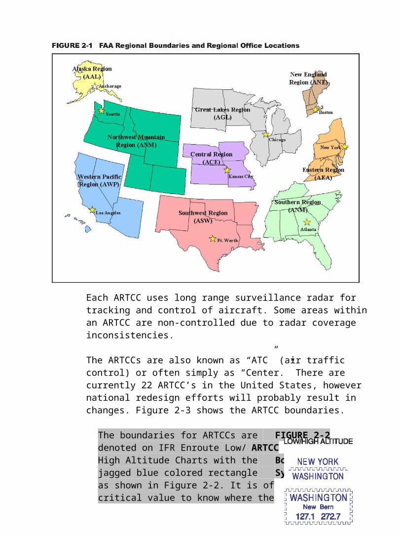
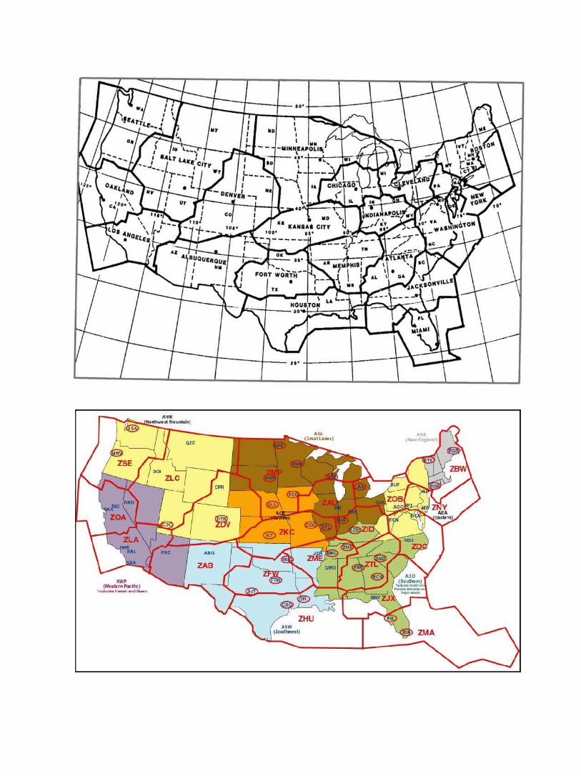
The FAA operates under the Department of Transportation (DOT) and is organized with a national headquarters and subordinate regions. The boundaries for the FAA regions are in Figure 2-1. FAA’s national headquarters provides policies and new or updated Federal Aviation Regulations which apply to airports, air traffic and airspace matters. Regional Headquarters are charged with administration and enforcement within their respective boundaries.
B. Air Route Traffic Control Center (ARTCC)
The ARTCC is the FAA facility which is primarily responsible for separation and control of enroute traffic operating under instrument flight rules (IFR). The ARTCC is the initiating facility for Federal Agency Regulation 91.137 Temporary Flight Restrictions (TFRs). See Chapter 6 for TFR information.
Each ARTCC uses long range surveillance radar for tracking and control of aircraft. Some areas within an ARTCC are non-controlled due to radar coverage inconsistencies.
The ARTCCs are also known as “ATC” (air traffic control) or often simply as “Center.” There are currently 22 ARTCC’s in the United States, however national redesign efforts will probably result in changes. Figure 2-3 shows the ARTCC boundaries.
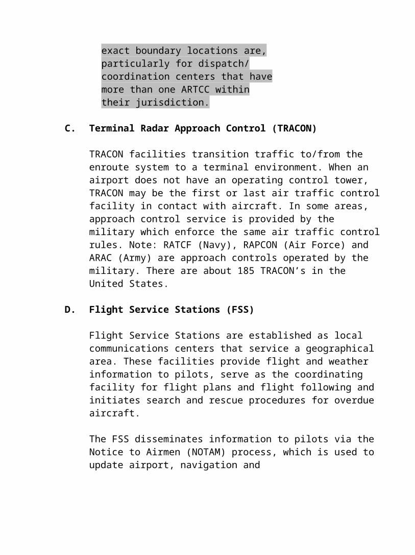
The boundaries for ARTCCs are FIGURE 2-2denoted on IFR Enroute Low/ ARTCCHigh Altitude Charts with the Boundaryjagged blue colored rectangle Symbolas shown in Figure 2-2. It is ofcritical value to know where theexact boundary locations are,particularly for dispatch/coordination centers that havemore than one ARTCC withintheir jurisdiction.
C. Terminal Radar Approach Control (TRACON)
TRACON facilities transition traffic to/from the enroute system to a terminal environment. When an airport does not have an operating control tower, TRACON may be the first or last air traffic control facility in contact with aircraft. In some areas, approach control service is provided by the military which enforce the same air traffic control rules. Note: RATCF (Navy), RAPCON (Air Force) and ARAC (Army) are approach controls operated by the military. There are about 185 TRACON’s in the United States.
D. Flight Service Stations (FSS)
Flight Service Stations are established as local communications centers that service a geographical area. These facilities provide flight and weather information to pilots, serve as the coordinating facility for flight plans and flight following and initiates search and rescue procedures for overdue aircraft.
The FSS disseminates information to pilots via the Notice to Airmen (NOTAM) process, which is used to update airport, navigation and
airspace status, including TFRs and Military Training Routes (MTRs) schedules. There are approximately 61 Automated Flight Service Stations (AFSS) in the Continental United States (CONUS) and 14 Alaskan Flight Service Stations.
E. Flight Standard District Offices (FSDOs)
Flight Standard District Offices (FSDOs) are the field operating units of each region; they provide education, inspections, investigations and enforcement of Federal Aviation Regulations. The FSDO is the office which conducts the primary investigation of pilot deviations (i.e., entering a TFR without permission) and near mid-air collision reports (NMACs). See Chapter 8 for further discussion of these reports.
F. The United States NOTAM Office (USNOF)
The United States NOTAM Office (USNOF) is charged with operating and monitoring the NOTAM System, managing the agency’s aeronautical information data base and collecting, validating and disseminating data for use by the charting and publication entities of the FAA, government and industry.
G. The National Flight Data Center (NFDC)
The National Flight Data Center is a facility in Washington, D.C., established by the FAA to operate a central aeronautical information service for the collection, validation and dissemination of aeronautical data in support of the government, industry and the aviation community. The NFDC monitors the NOTAM system for compliance with established criteria and procedures.
II. Department of Defense
The DoD Services (Army, Navy, Marine Corps and Air Force) must continually train with a wide variety of tactics in a variety of environments. With FAA concurrence, specific areas and routes have been established to provide airspace necessary for the military mission. In most cases, these areas and routes are represented on a number of charts to inform the public that increased vigilance and alertness are required due to the possibility of military aircraft operations in the area; while exercising the “see and avoid” concept of Visual Flight Rules (VFR). In addition, charting may provide segregation for hazardous ground operations. Each of the DoD services have flight rules and policies in addition to the Federal Aviation Regulations.
A crucial key in airspace coordination is understanding the kinds of airspace in which the DoD flies and how to contact the appropriate DoD facility that schedules the airspace. The types of airspace that DoD typically uses is covered in Chapter 3, Airspace Basics. The following DoD personnel are key contacts that work on airspace issues:
A. Military Representative to the FAA (MilReps)
Each military service has designated persons within most FAA regions to facilitate coordination with the FAA on air traffic and airspace issues, each of the military services have designated representatives to interface directly with the FAA. These personnel are referred to as AFREPS (Air Force and Air National Guard), NAVREPS (Navy/Marine Corps) and DARR (Army). The MilReps are frequently a good starting point for locating military points of contact dealing with airspace issues.
The MilReps also provide guidance and coordination services to their assigned military units to coordinate creation and changes to airspace and serve as a focal point for disseminating information concerning hazards to navigation and other general airspace information. MilReps commonly deal with the following issues: noise complaints, flight violation reports, airspace proposals, EIS/EA scoping meetings and airspace user forums. They provide an interface with land management agencies and serve as liaison to state, local and other government agencies.
Additionally each Service provides representation at FAA headquarters in Washington, D.C.
1. Air Force Representative (AFREP)
Regional AFREPs are established at FAA regional headquarters offices. Each AFREP represents the Department of the Air Force (USAF) and the Air National Guard (ANG) Commands through liaison with the FAA. They are authorized to coordinate, negotiate and communicate USAF/ANG positions on airspace and air traffic control matters within established policy and guidelines. The AFREPs represent the USAF in negotiations with competing aviation and land use interests, and assists with airspace proposals and environmental documents.
2. Navy Representative (NAVREP)
Navy Representatives to the FAA (NAVREPs) represent the Navy and Marine Corp and are located at most FAA regional headquarters. They
provide liaison between the FAA and the Department of the Navy (DON), assuring that regional DON airspace matters are consistent with national DON policy. NAVREPs provide technical guidance and procedural assistance in matters such as sonic boom or jet noise complaints, flight violation reports, near mid-air collision reports, TFR intrusions and airspace proposals.
3. Army Representative (DARR)
Department of the Army Representatives to the FAA (DARR) serve at FAA regional headquarters and provide assistance to local Army commands. This includes coordination of air traffic and airspace actions with the FAA regional headquarters as well as the investigation of flight violations involving Army assigned airspace and aircraft. They provide local Army commanders with technical expertise and assistance in areas that significantly affect Army airspace, air traffic control, aeronautical information, aviation matters and Special Use Airspace. They are the liaison with land management agencies in coordinating airspace issues. Additional information is available at www.usaasa.belvoir.army.mil .
B. Other Sources of Assistance Within DoD
1. Airspace Manager
Airspace managers have been assigned at some military facilities. These managers are responsible for working with the FAA and other agencies to identify, coordinate, procure and manage airspace, and to develop and coordinate agreements/procedures to support military flight operations in meeting both peace and war time requirements.
2. Air Traffic Representative (ATRep)
An ATRep is an FAA Air Traffic Representative. Some military facilities have an ATRep assigned to serve as a liaison officer between the military and the FAA and between the military and civil users. They serve as a technical advisor in all phases of air traffic control in order to improve ATC service, evaluate the amount of airspace required for ATC and coordinate approval of airport traffic pattens. They participate in appropriate intra-military meetings in which the FAA has an interest, encourage lecture and training programs for base pilots and civil air user groups and recommend
changes, if necessary to improve service. ATReps can be useful resources in coordinating with a DoD facility regarding specific airspace issues.
C. Using, Controlling and Scheduling Agencies/Activities For SUA/MTR
MTRs and SUAs must be scheduled for use by DoD aircraft. DoD schedulers are tasked as either Scheduling Activities for MTRs or Scheduling Authorities for SUAs. Schedulers are the front line resources that dispatch calls to deconflict or share airspace coordination information. The offices are listed on sectionals or DoD AP/1A for SUAs and the DoD AP/1B Handbook for MTRs, Slow Routes, Aerial Refueling Routes.
When coordinating with DoD facilities regarding airspace issues, the following organizational terminology applies:
1. Using Agency
The Using Agency is that agency or military command organization designated by the FAA as responsible for the administration and management of the designated SUA/MTR. Normally, this is the cosigner(s) on the Interagency Airspace Agreement for the SUA/ MTR.
2. Scheduling Agency/Activity
The Scheduling Agency/Activity is that organization responsible for scheduling and day-to-day administration of the SUA or MTR on behalf of the Using Agency. The Scheduling Agency may be the same as the Using Agency or may be a delegated organization. Airspace will not be used for military activities unless scheduled by the responsible military office. There may also be an alternate Scheduling Agency/Activity for after-hours or weekend coordination. Note that the:
Scheduling agency is the DoD term associated with SUA. Scheduling activity is the DoD term associated with MTRs.
3. Controlling Agency
The controlling agency is the FAA or military designated facility responsible for air traffic control for a SUA. The controlling agency
could either be an ARTCC responsibility, a TRACON facility, or a Military RAPCON facility. Controlling agencies for SUA’s are listed on the legend of a sectional chart or in the DoD AP/1A.
III. Land Management Agencies (USDA-FS, DOI and States)
The United States Congress has charged the federal land management agencies, primarily the USFS and bureaus of the DOI, to administer public lands in the public interest. Similar responsibilities are assigned to State agencies. Although not a regulator of airspace, the land management agencies operate within the airspace above public lands in the administration of public service. As a user of the NAS, agency flights are bound by the Federal Aviation Regulations. This use is primarily conducted at the same altitudes at which much of the military trains and general aviation operates.
Most federal land management agencies (both USFS and DOI) have headquarters offices in Washington, D.C. They are further divided by region, area, or state, with sub-units of these divided into National Forests (USFS), districts (BLM), reservations (BIA), National Parks and Monuments (NPS), and National Wildlife Refuges (FWS). Maps of the boundaries for these agencies may be found in Appendix B.
Not all government agencies are alike in organization or structure. Roles and responsibilities will overlap in some cases, and differ in others.
A. Land Management Dispatch/Logistical Support Organizations
Land management agencies that manage natural resources have a designated ordering procedure to support wildland fire use and suppression as well as natural disasters. Wildland fires and natural disasters are called “incidents” and are frequently managed using the Incident Command System (ICS). Associated with ICS are established ordering channels that provide for rapid movement of personnel, aircraft and equipment in an efficient and effective manner to support incidents. There are three primary levels of coordination centers: national, geographic area and local.
1. National Interagency Fire Center (NIFC) (http://www.nifc.gov)
The National Interagency Fire Center (NIFC) in Boise, Idaho includes the nation’s primary logistical support center for wildland fire suppression. The center is also home to federal wildland fire
experts in fields as diverse as fire ecology, fire behavior, technology, aviation and weather. Working together and in cooperation with state and local agencies, NIFC’s role is to provide national response to wildfire and other emergencies, and to serve as a focal point for wildland fire information and technology.
2. National Interagency Coordination Center (NICC)
The national response level is coordinated at the NICC which is part of the NIFC in Boise, Idaho. NICC is responsible for coordination and support of all resource movement between the Geographic Area Coordination Centers (GACCs) that are not covered by local operating plans.
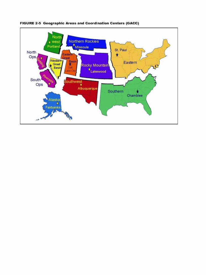
3. Geographic Area Coordination Centers
Each of the 11 geographic areas is coordinated at a GACC (see Figure 2-5). GACCs act as focal points for internal and external requests for personnel, equipment and resources that cannot be filled at the local level.
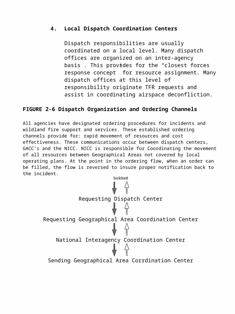
4. Local Dispatch Coordination Centers
Dispatch responsibilities are usually coordinated on a local level. Many dispatch offices are organized on an inter-agency basis . This provides for the “closest forces response concept” for resource assignment. Many dispatch offices at this level of responsibility originate TFR requests and assist in coordinating airspace deconfliction.
FIGURE 2-6 Dispatch Organization and Ordering Channels
All agencies have designated ordering procedures for incidents and wildland fire support and services. These established ordering channels provide for: rapid movement of resources and cost effectiveness. These communications occur between dispatch centers, GACC’s and the NICC. NICC is responsible for Coordinating the movement of all resources between Geographical Areas not covered by local operating plans. At the point in the ordering flow, when an order can be filled, the flow is reversed to insure proper notification back to the incident.
Requesting Dispatch Center
Requesting Geographical Area Coordination Center
National Interagency Coordination Center
Sending Geographical Area Corrdination Center

VI. Land Management Agencies Roles And Responsibilities
Airspace coordination is the responsibility of multiple agencies including land management agencies. Specific agency missions result in some diversity of airspace and safety requirements. The airspace above public lands is not owned by the agencies and proper coordination is a key to safe use.
The following provides an overview of the roles and responsibilities of land man-agement organizations who are involved in airspace coordination.
A. State or Regional Aviation Manager
State or Regional Aviation Managers provide leadership and oversight for agency airspace programs. If one is not available, consult with a national aviation program manager. Where appropriate, the State or Regional Aviation Manager has the responsibility to:
1. Evaluate the airspace system and potential problems within their particular jurisdiction.
2. Coordinate with the FAA, military, and the agency airspace coordi-nation representative in regard to airspace coordination issues.
3. Coordinate with other cooperating federal and state land management agencies to initiate Airspace Agreements with military facilities.
4. Ensure that all dispatchers, aviation managers, and other appropriate personnel receive training in airspace coordination policy and procedures.
5. Disseminate and discuss airspace coordination policy and procedures with local military services, law enforcement, news media, and the FAA.
6. Collect, compile, analyze and disseminate all SAFECOMs (Safety Communications) involving airspace conflicts. Share SAFECOM information with DoD and FAA when appropriate.
7. On projects which affect multiple agencies or areas, coordinate with the affected local aviation managers, resource managers, and military facilities regarding airspace activities that may affect environmental resources on land, or land management activities that may affect airspace.
8. Review airspace and environmental proposals (Environmental Assessments and Environmental Impact Studies, Federal Register notices, etc.) for agency aviation concerns. Relay aviation concerns via the FAA circularization process or through the NEPA process.
9. Acquaint agency planners and natural resource managers with current airspace structure over agency lands.
10. Maintain awareness of local aeronautical issues (new airports, obstructions, noise abatement procedures, local fly-in or air shows) that may have an impact on airspace.
B. Agency Resource Managers
Agency Resource Managers provide management of natural and cultural resources on public lands. This can include federally designated wildernesses, wild and scenic rivers, and national recreational areas and congressional designated areas. Where appropriate, the Agency Resource Manager has the responsibility to:
1. Review airspace and environmental proposals and aviation projects as they pertain to environmental resource management. Information regarding current airspace structure can be obtained from the State or the Regional Aviation Manager.
2. Coordinate with aviation managers and military facilities to mitigate the impact of airspace activities on environmental resources, and the impact of land management activities on the airspace.
3. Provide technical advice on overlying airspace when reviewing proposals and plans for structure construction. See Chapter 4 for further information regarding obstruction evaluations and approvals as prescribed by the FAA.
C. National Interagency Coordination Center (http://www.nifc.gov)
NICC coordinates and supports operations for managing wildland fire suppression and natural disasters throughout the United States. NICC has the responsibility to:
1. Maintain the Interagency Airspace Agreement for temporary towers with the FAA’s Northwest Mountain Region.
2. Coordinates the requests for temporary towers located in the following states: Washington, Oregon, Idaho, Colorado, Wyoming, Utah and Montana.
3. Coordinates resource orders for airspace coordinators (technical specialists) when the position cannot be filled on a geographic basis.
D. Geographic Area Coordination Center
1. Where appropriate the GACC has the responsibility to:
2. Coordinate TFRs and DoD deconfliction upon request. Track current TFRs or areas of air operations in local jurisdictions. Modify TFRs when necessary (see local dispatch/aviation staff responsibilities if GACC has TFR responsibilities).
3. Coordinate with appropriate FAA ARTCC facilities, particularly during large, adjacent multiple-fire operations, to avoid overlapping or conflicting airspace restrictions.
4. Publish daily TFR information through intelligence reports or GACC websites. Immediate relay of documentation of airspace conflicts received from local units (dispatchers or aviation managers) to the appropriate State or Regional Aviation Manager.
5. Develop a comprehensive listing of phone and fax numbers for the MTRs, SUAs, and FAA facilities within its jurisdiction. Publish them in the State, Area or Regional Mobilization Guide as appropriate.
6. Maintain current sets of aeronautical sectional charts and the DoD AP/1B handbook and charts.
7. Maintain Airspace Agreements with FAA Regional Headquarters regarding ordering and staffing of temporary towers.
8. Work with Airspace Coordination Specialist (THSP-Airspace) when the position is assigned. Some or all duties, including receipt of TFR requests and implementation with FAA may be transferred to the Airspace Coordination Specialist.
E. Local Dispatch and Aviation Staff
Airspace coordination with the FAA and the DoD is primarily a local responsibility. Where appropriate, local dispatchers and/or aviation managers have the responsibility to:
1. Evaluate potential airspace issues within their jurisdiction. Maintain airspace awareness within their response area.
2. Coordinate TFRs and other NOTAMs to include:
a. Relaying information on identified airspace hazards or concerns to pilots and/or on-scene aviation personnel. Ensure that radio frequencies are distributed to expedite communications over an incident.
b. Coordinate the need for TFRs/NOTAMs. Obtaining complete information and documentation to meet FAA’s needs. For further information see Chapter 6, TFRs and NOTAMs.
c. Request TFRs/NOTAMs from the appropriate ARTCC and forward a copy to the GACC and other affected facilities (DoD, etc.). Coordinate with neighboring agencies. Document requests via agency procedures (i.e. resource orders, TFR request form, etc.).
d. Monitor and modify TFRs/NOTAMs requests as needed. Coordinate modifications with on scene personnel and determine size and shape of the TFR as the incident or project size changes. Modify NOTAM if TFR related frequency changes.
e. Verify the TFRs/NOTAMs are published as requested, and the facilities affected have timely notification (especially FSS and military units). Access NOTAM via Internet or DUAT or have the Flight Service Station fax the actual NOTAM to the dispatch office for verification.
f. If problems or conflicts are encountered during the TFRs/ NOTAMs, document via agency procedures and notify agency management (i.e., SAFECOM).
g. Brief local initial attack and other participating aircraft on procedures for entering airspace (initial points of contact for entry, etc.).
h. If the airspace becomes unsafe, it is the responsibility of the individual who is aware of the hazard to ensure operations are temporarily suspended until the conflict is resolved.
i. Notify (i.e. e-mail and/or fax) agency pilots and other affected personnel that the TFRs/NOTAMs are in place. This may include helibases, air tanker bases, incident command posts, all dispatch offices within GACC boundaries and neighboring units, airports, etc.
j. Cancel TFRs/NOTAMs immediately when the restriction is no longer necessary. Coordinate with on scene official-incharge (i.e. Incident Management Team, etc.).
3. Document all Near Midair Collisions (NMACs) and instances of TFR intrusions. Immediately notify the FAA, the military (if appropriate), and the State or Regional Aviation Manager of any NMACs or intrusions.
4. Notify affected agencies and personnel of airspace activities and hazards that do not receive FAA’s TFRs/NOTAMs notifications. Brief non-local inbound aircraft on updated frequencies and airspace coordination information and procedures.
5. Develop a comprehensive listing of phone and fax numbers for the MTRs, SUAs, and FAA facilities within unit jurisdiction. Maintain a list of critical airspace contacts and publish them in the State, Area or Regional Mobilization Guide.
6. Participate in pilot pre-contract and pre-use briefings and discuss unit airspace procedures and problems.
7. Coordinate mitigation of airspace activities impact on environmental resources, and the impact of land management activities on the airspace with resource managers and military representatives.
8. Maintain current sets of sectionals and the DoD AP/1B handbook and charts.
9. Coordinate airspace deconfliction for non-emergency activities such as blasting, reconnaissance flights and prescribed burning activities.
10. Maintain knowledge of the NAS and the NOTAM System.
11. Maintain aviation maps with airspace hazards.
12. Maintain knowledge and proficiency in agency airspace deconfliction program (CAHIS, IAMS, ROSS, CAN, etc.).
F. Pilot
As a user of the NAS, the pilot flies according to the Federal Aviation Regulations. Pilots who fly for land management agencies (as either employees or contractors) must, in addition to the FARs, comply with agency regulations and procedures as well as contractual clauses. Where appropriate, the pilot has the responsibility to:
1. Be familiar (preflight) with all available information concerning the flight including that which pertains to the airspace involved in the area of operations.
2. Determine the status of SUAs/MTRs prior to flight near or within operational airspace.
3. Report all airspace conflicts to the appropriate authority and agency personnel using agency or contractual procedures.
4. Report NMACs to the FAA. Report information to appropriate agency aviation safety personnel.
5. Refrain from operating an aircraft so close to another aircraft as to create a collision hazard.
6. Fly with lights on (if possible) when in known SUAs or MTRs to enhance visibility.
7. If possible squawk with Air Traffic Control for deconfliction and use the national fire transponder code (1255) when appropriate.
8. Be familiar with agency procedures to enter incident airspace including flight following, dispatch coordination and frequency procedures. Remain clear of TFR until contact is established.
9. When flying on incidents where a TFR is in place:
a. Remain clear of the TFR area when not assigned or until contact can be made with the air tactical group supervisor (ATGS) or aerial supervisor for transit through the TFR.
b. Establish contact with the ATGS for the assignment of aircraft routes, orbit altitudes, etc., if assigned to an incident.
c. Maintain assigned altitude or block assigned altitude unless altitude change is cleared by ATGS or aerial supervisor.
10. When flying on incidents where a TFR is not in place, remain clear of the incident area until contact can be made with the ATGS or aerial supervisor for entry into the area of operations.
11. Participate in briefings and debriefings, identify any problems encountered and recommending any corrective action necessary. Update base manager/dispatch with any changes (e.g. frequencies, incident outside of TFR, etc.).
The Pilot in Command (PIC) of an aircraft is directly responsible for,and is final authority as to the operation of the aircraft (14 CFR 91.3).
G. On-Scene Personnel
On-scene personnel include, but are not limited to, aerial observers, aircraft managers (chief of party, etc.), project aviation managers, air tactical group supervisors (ATGS), air tanker coordinators, air operations branch directors (AOBD), air support group supervisors (ASGS), helitack personnel, division/group supervisors and incident commanders. When appropriate, on-scene personnel have the responsibility to:
1. Maintain knowledge and awareness of the airspace in which they are operating. Obtain or conduct briefings regarding incident airspace and associated hazards (i.e. MTRs, SUA, obstructions, etc.).

2. Provide accurate information needed for local dispatchers or aviation managers to request or modify a TFR. Relay modifications or updates as necessary relating to: Incident location Frequency Center point if circular, corner coordinates if non-circular Latitude and Longitude Radius if circular Altitude MSL Air-to-Air VHF-AM Contact Frequency Special considerations (within Class B, C or D airspace
areas, airports, etc.) Initial points for entry into TFR Incident growth potential
3. Brief responding and on-scene pilots about TFRs and known airspace hazards. Encourage lights on (strobe and pulsating lights) for safety.
4. Be familiar with agency procedures regarding aircraft entry into incident airspace.
5. When operations within incident airspace become unsafe, ensure that operations are temporarily suspended until unsafe situation is mitigated.
6. When releasing aircraft from the incident, brief pilots regarding TFRs at other sites so they may avoid intrusions.
7. Identify and correct unsafe airspace operations. Follow through with SAFECOMs via agency procedures.
8. Consult with agency aviation personnel when risk assessment indicates the need for an FAA Temporary Tower.
9. Keep dispatch updated on frequency changes for incident aircraft.
10. Report and document all airspace conflicts to the appropriate authority and agency personnel using agency procedures.
11. Notifying the appropriate local dispatch office or aviation manager once the agency flight operations have changed or ceased.
H. Air Tactical Group Supervisor
The ATGS is responsible for the assignment of all incident aircraft in safe orderly holding and mission flight patterns and routes. In addition to the on-scene responsibilities, the ATGS performs a critical safety responsibility as air traffic control. Responsibilities are outlined in detail in the Interagency Air Tactical Supervisors Guide. This task requires the following basic responsibilities:
1. Conduct a briefing each morning that provides updated, accurate airspace information regarding TFRs, ingress, egress, etc. (Note: May be performed by Air Tanker Base Manager or Helibase Manager.) Briefings are covered in Chapter 7, Airspace Deconfliction.
2. Follow established agency procedures for entering and exiting the airspace.
3. Give and request position reports within the airspace.
4. Advise pilots of other air traffic and of air traffic hazards.
5. Maintain radio communication with all assigned aircraft in the airspace.
6. Maintain visual contact for “close traffic work”.
7. Monitor status of all assigned incident aircraft in the airspace.
8. Assign flight patterns and routes to establish safe vertical and horizontal separation as guided by the Interagency Air Tactical Supervisors Guide. Pilots must be consulted before establishing complex routes or patterns.
9. Coordinate media, VIP and other agency flights within TFR.
10. Conduct debriefing and recommend any necessary corrective actions regarding airspace.
I. Airspace Coordination Specialist (THSP)
May be ordered to assume or assist with airspace duties. An Airspace Coordinator Specialist should be ordered when incident activity is widespread and involves a number of complex TFRs, complex airspace is involved or difficult conflict resolutions exist with various agencies. A working knowledge of IAMS/CAHIS is required.
NOTE TO DISPATCHERS: This position should be ordered as a technical specialist (THSP). Airspace Coordination Specialists can function in a variety of situations and at various levels within the organization. Please designate the level of expertise when ordering (i.e. Field, GACC, Local, Support).
1. Field Airspace Coordinator Specialist
Reports to the National Airspace Program Manager. Ordered to assist with airspace coordination in the field among Area Commands, Incident Management Teams, Dispatch organizations, local airports, general aviation, FAA offices and DoD office. Must have extensive experience coordinating airspace issues. May be accompanied by an assistant or GIS Specialist.
2. GACC Airspace Coordinator Specialist
Often located at a GACC and supports airspace activity within a GACC boundary. Usually has extensive aviation and dispatch background to facilitate coordinating activity.
3. Local Unit Airspace Coordinator Specialist
Supports airspace activity within a local unit and can often assume airspace coordination duties relieving local unit dispatchers so they can concentrate on initial attack and large incident support. Often has Initial attack background as a dispatcher.
4. Airspace Coordination Specialist Support
Positions to support the airspace program. Must have knowledge of IAM/CAHIS and various aviation programs to support the Airspace Coordinator Specialist. Could be a webmaster, computer programer, GIS specialist, Mapping specialist or likewise.
When appropriate, the Airspace Coordinator has responsibility to:
1. Plot all current TFRs on sectionals. Assess situations involving: Classes of Airspace Airport Approaches and Departures Flight Schools, Sky Diving Schools Congested Airspace, Special Use Airspace, MTRs and
unpublished airspace situations Cruise Missile Routes
2. Contact involved ARTCC’s with assessment of incident situation and discuss airspace coordination and TFR procedures.
3. Coordinate the ordering of TFRs with Dispatch. TFRs ordering will involve an Aircraft Resource Order for document purposes. Maintain a log of ALL airspace discussions (for legal purposes). Airspace coordinator will maintain documentation. Airspace Coordinators phone number may be published on all related TFRs.
4. Distribute current TFRs to Incident Management Team’s aviation operations. Discuss size and altitudes involved.
5. Coordinate the combining of TFRs when they overlap. Non-circular TFRs are acceptable when coordinated with FAA ARTCC and are described in such a way that the U.S. NOTAM office can publish them. Ask AOBDs to modify airspace on a timely basis, particularly if they can downsize the area or lower the ceiling.
6. Obtain copies of any Airspace Agreements involving land management agencies and military bases. Contact Scheduling Activities (MTRs) or Controlling Agencies (SUAs) with maps of current TFRs. Provide briefing, discussing airspace deconfliction and procedures for handling intrusions.
7. Obtain copies of TFRs (FDC NOTAMS) from the Internet, DUATs, or the FAA. Carefully check published NOTAMs with TFR requests and verify that they are accurate with no typographical errors. Check NOTAMs on a daily basis.
8. Brief incoming Incident Management Teams, ATGSs and any other assigned pilots on the current TFRs and known airspace hazards.
9. Coordinate with other agencies. Non-participating agencies often have to continue their work and will be in contact to ask for permission to fly within the TFR. Provisions are already established for media and Law Enforcement entry. Establish contact with respective Air Operations Branch Director and coordinate the agencies request for entry (i.e. mosquito spraying, highway survey, etc.). Non-participating aircraft should only be allowed into a TFR when it is feasible, safe and previously coordinated so that frequencies are shared.
10. Receive reports of any intrusions. Take immediate action with ARTCC and or MilReps and Scheduling Activities/Scheduling Agencies. If the intruder is Military, ask for assistance from the Military Operations Specialist (MOS) at the Area Managers desk at ARTCC.
11. Assure that a SAFECOM be filed for any airspace intrusions. Follow through with FAA, DOD, Media or AOPA contacts on an as needed basis.
12. Adjust TFRs on an as needed basis (after conferring with the appropriate Air Operations Branch Director). Credibility and good faith will be established if airspace is given back to the FAA when it is no longer needed.
13. Coordinate publishing a list of daily TFRs in the Air Operations Plan. The list should include: NOTAM number, VOR/DME, ALT, Radius, Latitude/Longitude, and Incident Name.
14. Follow requests for temporary towers. Coordinate any staffing issues with FAA, AOBD and dispatch.
During extremely complex situations, the Airspace Coordinator may find it appropriate to:
1. Contact FAA Regional 520 Airspace Branch Manager with executive briefing and ask for assignment of a FAA Regional Headquarters Liaison.
2. As necessary, brief daily with TFR depictions and assessments:
ARTCC, FSDO, FSS Appropriate FAA Towers and involved airports MilReps (AFREP, NAVREP, DARR, ATREP, etc.)
All involved DoD Bases FAA Regional Headquarters Liaison Air Tanker Bases, Helibases, Smokejumper, Rappel Bases Incident Management Teams (All Air Ops Branch Directors) GACCs and Dispatch Centers National Broadcasting Pilots Association (NBPA) AOPA Regional Rep or AOPA Pilot Hotline
3. Contact local NBPA members and assess media coordination regarding TFRs.
4. Contact AOPA national office or regional representative with briefing. Establish coordination with AOPA Pilot Hotline and daily briefings with AOPA.
5. If needed, ask FAA Regional Headquarters Liaison if the FAA will issue a press release identifying TFRs and the need for General Aviation pilots to remain away from the incident area.
6. Presidential and Vice Presidential visits will be coordinated through the local ARTCC and assigned FAA Regional Headquarters Liaison. The FAA will coordinate the 14 CFR 91.141 Presidential TFR.
7. Discuss the 1255 Transponder Code with the FAA. Assure that local FAA is aware of transponder frequency. If they are unaware, share documentation of assignment and fax info to local towers and ARTCCs.
8. Coordinate mailing of airspace or TFR posters to all incidents and involved airports with an attached letter discussing the safety aspects of staying away from TFRs.
V. Airspace Committees
Either through acts of Congress, delegations of the military or public interest, many airspace committees exist. The following committees have been developed to provide interagency involvement and cooperation between agencies and public interest groups.
A. Interagency Airspace Natural Resource Coordination Group (IANRCG)
The IANRCG was a national committee formed in 1994 upon direction
from the Senate Armed Services Committee to the Secretaries of Defense and the Interior. The intent of the committee was to resolve airspace conflicts between the DoD, the USFS and the DOI agencies. The Coordi-nation Group provided a forum for interagency discussion, integrated planning, collaborative dispute resolution, and facilitation of local and regional issues concerning the use of the nations federally protected land resources and airspace. IANRCG was comprised of all branches of the DoD and members representing the BLM, USFS, FWS and BIA. IANRCG has a charter (see Appendix D) and has three sub-committees:
Education and Awareness Safety and Operations NEPA Compliance and Environmental Affairs
IANRCG increased awareness of airspace and was instrumental in the resolution of many problems. The committee has not met for several years as the focus on issues is now regionally or locally.
B. USAF/ANG Airspace and Range Council Meetings
The Airspace/Range Council Meetings were begun in 1989 and modeled after the Air National Guard long range planning process. In 1995, Air Force Headquarters formally endorsed the regional process and now co– chairs and sponsors all council meetings.
These meetings ensure Air Force offices involved in an airspace/range issue have a common understanding of the objectives, status and key issues, and provide for a thorough review by an interdiscipli-nary team. The meetings Council Meeting Boundariesincorporate interagency involvement and cooperation at the appropriate level.
The meetings exist regionally and nationally to advise units, major commands, and Air Force Headquarters on airspace and range issues, and to provide all council members with a flow of information and lessons learned in airspace and range development. DoD
airspace meetings are aligned with FAA regional boundaries, which provide a geographic focus on airspace/range issues.
Council meetings may be hosted by the units, major commands, and/or Regional AFREPS. National Councils are convened annually to allow senior Air Force leaders to review pending and proposed range and airspace actions from a national perspective and provide feedback to regional councils.
They are open to delegates from all military services, land management agencies, and other interested or concerned parties with which the Air Force should exchange constructive information concerning flight activities in the region
C. Interagency Military Land Use Coordination Committee (IMLUCC)
This committee was formed in 1997 to enhance dialogue on land use issues of mutual interest to the DoD, DOI, USFS, and the DOT. The mission of the committee is to facilitate cooperation and communication at the policy level. IMLUCC membership is at the Deputy Under Secretary level within the DoD and USDA and at the Assistant Secretary level with in DOI. The scope of issues dealt with by IMLUCC is broad and includes the following subcommittees:
Land Withdrawal Special Uses Joint Stewardship Contamination/Clean-up Overflight/Airspace
D. Federal Interagency Committee for Aviation Noise (FICAN) (www.fican.org)
Federal Interagency Committee for Aviation Noise (FICAN) was formed in 1993 to provide forums for the debate of future research needs to better understand, predict and control the effects of aviation noise. FICAN members include DOT, DoD, NASA, EPA, HUD and NPS.
E. DOT/NPS Interagency Working Group (IWG) (www.nps.gov)
In 1987, Congress enacted Public Law 100-91, commonly known as the National Parks Overflights Act. It required the US Forest Service and the
NPS to submit reports to Congress on the effects of overflights on Forest Service wilderness areas and National Park Service units resources and visitor experiences. It further required the NPS submit to the FAA recommendations associated with the effects of overflights. The law also required the FAA to prepare and issue a final plan for the management of air traffic above the Grand Canyon and implement the recommendations of DOI.
On December 22, 1993, the Secretary of Transportation (Pena) and the Secretary of the Interior (Babbitt) formed an interagency working group (IWG) to explore ways to limit or reduce the impacts from overflights of national parks, including the Grand Canyon. Noise generated by the air tour industry has received the most attention, however, all components of aviation are likely to be impacted by this Act.
As a result, the IWG (comprised of NPS and FAA) have been working together to implement the NPS recommendations from the NPS Overflight report of 1994. So far regulatory action has been limited to only a few parks such as Grand Canyon, Hawaiian Volcanos and Haleakala where special federal aviation regulations (SFARs) have been developed as interim measures. Rocky Mountain National Park has legislation that was passed by Congress that prohibits commercial air tour operations over the park.
The National Parks Air Tour Management Act was passed in 2000. It provides for the regulation of commercial air tours throughout the National Park System. The Natural Sounds Program Office opened in October of 2000 and is headquartered in Ft. Collins, Colorado. The programs priority is to work with the FAA to implement the National Parks Air Tour Management Act of 2000. The two agencies are required to jointly develop an Air Tour Management Plan (ATMP) for every national park where air tours exist or are proposed.
F. DoD Policy Board on Federal Aviation (PBFA)
The DoD management of airspace designated for military use is decentralized. Each of the military services has a centralized office that sets policy and oversees airspace matters for that military branch. Joint service airspace issues or inter-service problems are resolved by a DoD headquarters committee, and the DoD PBFA. The PBFA has established a subcommittee with primary interest in DoD airspace issues.
G. FAA Users Group/Users Forum
The FAA sponsors local meetings quarterly to allow users groups of local airspace to provide input to airport improvements, airspace issues or other topics, and to provide a forum for information sharing. Contact your local FAA office to find times and places for scheduled meetings.
H. Other Committees and Groups
There are many other committees and interest groups. Colorado, Alaska, Idaho, California all have active Airspace Advisory Groups that coordinate airspace issues. They are frequently associated with either the State Aviation Board or the Governors office.
VI. Aviation Interest Committees and Groups
A Aircraft Owners and Pilots Association (AOPA) (www.aopa.org)
AOPA consists of over 350,000 members. AOPA is often referred to as the “voice of General Aviation.” AOPA pursues public acceptance of general aviation. They work closely with the FAA, NTSB, and the US Congress to ensure that the interests of its members are well represented. AOPA is a watchdog for airspace issues that threaten the “public right to freedom of transit” as outlined in the 1958 National Airspace Act.
B. National Business Aircraft Association (NBAA) (www.nbaa.org)
NBAA is the voice of business aviation and maintains strong relationships with government and industry. Through staff analysis of proposed govern-mental legislative and rule changes, they alert Congress and its members of any airspace proposals that might affect airspace usage by NBAA members.
C. Helicopter Association International (HAI) (www.rotor.com)
Since it’s inception nearly 50 years ago, the Helicopter Association International (HAI) has brought together helicopter professionals from around the globe to share insights and information about succeeding in a climate of change and challenge. HAI sponsors an annual workshop that incorporates forums, exhibits and training. More than 10,000 professionals attend Heli-Expo annually. At Heli-Expo, HAI often hosts a panel
discussion that focuses on land management agencies involvement with airspace issues.
D. National Broadcasting Pilot’s Association (NBPA)(www.nbpa.rotor.com)
The National Broadcasting Pilots Association (NBPA) is an advocate of the “Freedom of the Press” and works closely with FAA headquarters personnel to ensure that the press will continue to have access to the nation’s airspace. NBPA is an organization for pilots and crew members flying Electronic News Gathering (ENG) aircraft for both television and radio as well as those companies directly involved in making aerial news possible.