Embed Size (px)
Citation preview
APR B01964
Channel Geometry of
Piedmont Streams as
Related to Frequency
of FloodsSCRANTON I
PUBLIC LIBRARY feom
GEOLOGICAL SURVEY PROFESSIONAL PAPER 422-E

Channel Geometry of
Piedmont Streams as
Related to Frequency
of FloodsBy F. A. KILPATRICK and H. H. BARNES, JR.
PHYSIOGRAPHIC AND HYDRAULIC STUDIES OF RIVERS
GEOLOGICAL SURVEY PROFESSIONAL PAPER 422-E
UNITED STATES GOVERNMENT PRINTING OFFICE, WASHINGTON : 1964

UNITED STATES DEPARTMENT OF THE INTERIOR
STEW ART L. UDALL, Secretary
GEOLOGICAL SURVEY
Thomas B. Nolan, Director
For sale by the Superintendent of Documents, U.S. Government Printing Office Washington, D.C. 20402

CONTENTS
Glossary.._ ______________________Abstract.. _ ______________________Introduction. ____________________The study area.__--__-__--__-____
General requirements__ _ _____Characteristics of the Piedmont. Selection of sites._____________
Field surveys___________________Observations on channel geometry _ _
PageIV
El 1 1 1 1122
Definition of bankfull stage._________________________Section properties as criterion for bankfull stage.__.Valley benches as criterion for bankfull stage...--..
Presentation of data. ___________---_-___--_-___--_-Frequency of bankfull discharge._________-____-_--__The effect of slope.______-_____-_____-__-_-___---__Variation of water surface slope with depth.__________Summary and conclusions....-.-..-_________________References cited____________________________________
Page E4
45
9101010
FIGURE
ILLUSTRATIONS
1.
2.
3.
45.
6.
Page Location of the channel geometry sites in the
study area ______ _ _ _ _ E2Plan view of Stevens Creek near Modoc,
S.C. ____-.___-_---_.-_.______________ 3View of rock outcrop below cross section
11 at Stevens Creek__ __ 3
View from left bank looking upstream toward natural levee at cross section 1 1 at Stevens Creek ___ __________ _ 5
View of deposition on the natural levee below cross section 11 at Stevens Creek __ 5
FIGURE
1
1
1
Formation of natural levee by deposition in the immediate vicinity of the stream bank at Murder Creek near Monticello, Ga____
Profiles of mean annual flood stage and various bench levels for Stevens Creek-.
9. Photograph indicating the existence of two prominent benches at Murder Creek. ____
10. Relation of bankfull depth to depth of mean annual flood for Piedmont streams. ______
Comparison of the data for 34 sites in the Piedmont with graph of equation 1 ______
Relationship between water surface slopes at low stage and at bankfull stage. ______
Page
E5
10
TABLES
TABLE 1. Channel-geometry sites near gaging stations._2. Supplementary channel geometry sites..____3. Data corresponding to the mean annual flood
and various bench levels for streams in the Piedmont.______________ ________________
PageE4
4

GLOSSARY
Bankfull stage. A river stage corresponding to the mean eleva tion of the predominant bench.
Bench. A relatively flat portion of land within a river valley.Channel slope. A ratio of fall to length for a given reach of
stream, usually expressed as feet per foot.Control. A reach or section of channel downstream from a
gaging station that determines the stage-discharge relation at the gage. A natural constriction of the channel, a sud den steepening of bed slope, or an artificial dam, is a section control; in the absence of a section control, a long reach of channel or a bend may be a channel control.
Depth. The difference between the average elevation of the bed of the main channel and the elevation of the water surface.
Flood plain. A relatively flat strip of land adjoining a river channel, which is associated with the stream in its present regime. This strip may or may not be the predominant bench in the valley.
Mean annual flood. The mean of the values in an array consist ing of the highest momentary discharge dui'ing each year of stream flow record; it is the discharge of the stream which is equalled or exceeded once each 2.33 years on the average.
Natural levee. An alluvial ridge on the flood plain, usually adjacent to the channel.
Predominant bench. The widest bench in a river valley which can be traced throughout a reach of river channel, and which is flooded at intervals by the stream.
IV

PHYSIOGRAPHIC AND HYDRAULIC STUDIES OF RIVERS
CHANNEL GEOMETRY OF PIEDMONT STREAMS AS RELATED TO FREQUENCY OF FLOODS
By F. A. KILPATRICK and H. H. BARNES, JR.
ABSTRACT
The relation of the height of valley benches to the height of water surfaces corresponding to floods of selected recurrence intervals was investigated at 34 sites in the Piedmont province, which lies in the southeastern part of the United States. The field investigation included surveys of the geometry of the channel and the measurement of water surface profiles during flood periods. The discharge-probability relation was estab lished from records at gaging stations.
The heights of the valley benches were found to be significantly related to the depth of flow corresponding to the mean annual flood, and to the slope of the stream channel.
INTRODUCTION
Recent investigations have indicated that the geom etry of a stream channel is related to the flow regime. Several investigators 1 (Wolman, 1955, p. 31; Wolman and Leopold, 1957, p. 89), have shown that the discharge at bankfull stage has a recurrence interval of 1 to 2 years. However, bankfull stage as used in these studies was more of a concept than a precise topographic defini tion. It was recognized that where terraces or aban doned flood plains exist, the active flood plain associated with present stream regimen is often difficult to define.
The purpose of this investigation was to define bank- full stage in relation to topographic features and to relate it to some index of discharge. The data required for the study included detailed surveys of the channel geometry along reaches of streams for which the fre quency of flood discharges was known from gaging-sta- tion records or areal studies.
Data used in this study were obtained in part from the district offices of the Geological Survey in Georgia, Alabama, North Carolina, and South Carolina. These offices also provided valuable assistance with the field work in obtaining the necessary profiles and cross sec tions at the study sites.
1 Walter B. Langbein (unpublished data) showed that the discharge at bankfull stage is roughly equal to the mean annual flood; this flood has a recurrence interval of 2.33 years.
THE STUDY AREA
GENERAL REQUIREMENTS
The selection of a study area was governed by physio graphic considerations. The study sites were selected within one broad area of generally similar physio graphic or geomorphic characteristics, the southern part of the Piedmont province. Similarity of physio graphic characteristics should imply similarity of stream channels. This area should provide a large degree of homogeneity among sites within the area.
CHARACTERISTICS OF THE PIEDMONT
The Piedmont province (see fig. 1) lies in eastern United States, bounded on the west by the Blue Ridge and on the east by the Coastal Plain. It extends south ward from Maryland into Alabama, a distance of about 700 miles.
The Piedmont is a nearly smooth undulating upland surface which slopes gradually southeastward. There are no ridges or peaks within the area that stand out conspicuously above the surrounding terrain. The crystalline rocks, which underlie the Piedmont, pass southeastward beneath the unconsolidated sediments of the Coastal Plain. The rocks have been subject to several profound deformations involving metamor- phism, igneous intrusion, close folding, and overthrust faulting.
The Piedmont is a peneplain which has been only slightly dissected and in which strong and weak rocks do not show marked differences in resistance to erosion. In general, the rocks are deeply weathered. The up lands, therefore, tend to be smooth, have few outcrops of fresh rock, and exhibit broad and shallow valleys hav ing long, gentle slopes. Rocks are exposed in many of the streambeds.
SELECTION OF SITES
Thirty-four sites were chosen for study from more than 200 stream-gaging stations currently maintained within the study area. These sites were selected pri-
El

E288°
PHYSIOGRAPHIC AND HYDRAULIC STUDIES OF RIVERS
86° 84° 82° 80°
U T H.--'' C A R 0 L I N A
FIGURE 1. Location of the channel geometry sites in the study area. Site numbers correspond to those in tables 1 and 2.
marily on the basis of (1) adequacy of the stage-dis charge relation to at least overbank stages, (2) freedom from regulation of floodflows, and (3) uniformity of the stream channel in or adjacent to the reach on which the gage is located. Drainage areas ranged from 1.6 square miles to 630 square miles. The selected sites were also well distributed with respect to location and altitude.
FIELD SURVEYS
Detailed information on channel geometry was ob tained at each of the 19 sites near gaging stations listed in table 1. Less detailed information was obtained at the 15 supplementary sites listed in table 2.
Transit-stadia surveys of a reach of channel were made at each site. An average of 12 cross sections were surveyed at sites near gaging stations, and 2 or 3 at the supplementary sites. The distance between cross sections was equivalent to about twice the width of the channel. A typical plan view of the location of cross sections is shown in figure 2.
Additional data obtained in the surveys included samples of bed and bank material, photographs, and profiles of highwater marks of one or more floods.
OBSERVATIONS ON CHANNEL GEOMETRY
Stream channels in the Piedmont follow a variety of courses that consist of rather sharp, short-radius bends, as well as long, gradually curving or almost straight reaches. Some of the reaches may extend for as much as a mile with only minor deviations from a straight line. In some places the benches are narrow and irregu lar, or almost nonexistent; in others, they are broad and flat.
The stream channels are deeply entrenched in many places, the present position being controlled by outcrops of rock. Even where the benches are broad and active meandering might be expected to occur, rock exposures are found in the streambed and along the channel banks (fig. 3).
This pattern is consistent with Lobeck's (1939, p. 223) suggestion of streams having alternating stretches of youth and maturity. The concept of temporary base levels may apply here.
The streambeds, in cross section, are nearly flat, and the bed materials range from fine sand to small boulders. Usually the streambed is highest near the center of the channel and deepest near the banks, which generally

CHANNEL GEOMETRY OF PIEDMONT STREAMS E3
Cross sections
Crest-stage gages
Volley limits
-/ Limits of bench systems Different bench levels
Natural levees ' '
FIGUEE 2. Map of Stevens Creek near Modoc, S.C.
rise rather steeply. The banks are usually protected near the top by trees and healthy growths of vines and bushes.
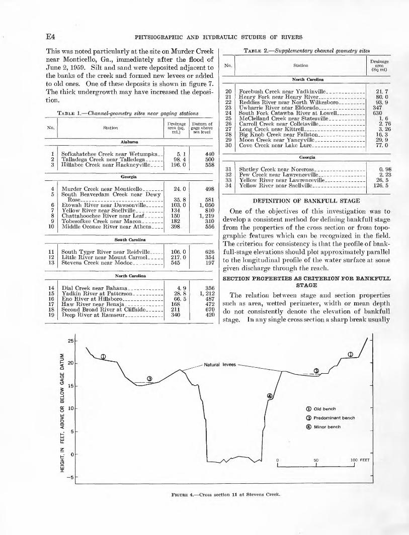
Natural levees and a complex system of benches exist at all sites. For example, the cross section of Stevens Creek in figure 4 shows natural levees and three separate benches at different elevations. The benches are also delineated in figure 2. The photograph shown as figure 5 was taken on the left bank of cross section 11 looking upstream. The mean annual flood corresponds to a stage about 4 feet above the top of the levee and 6 to 7 feet above the bench.
Another phenomenon noted at Stevens Creek was the active deposition of mud and fine silt on the natural levees. The amount of deposition on the levee just below cross section 11 is easily discernible in figure 6. The trees stand in "sinkholes" formed by deposition occur ring everywhere except in the immediate vicinity of the tree trunks, where local velocities are higher. The reach on Stevens Creek has a very flat slope, which may explain the large amount of deposition, but deposition also occurs on the immediate banks of many of the streams regardless of channel width, depth, or slopes.
FIGURE 3. View of rock outcrop below cross section 11 at Stevens Creek. These rock outcrops are typical of Piedmont streams.
E4 PHYSIOGRAPHIC AND HYDRAULIC STUDIES OF RIVERS
This was noted particularly at the site on Murder Creek near Monticello, Ga., immediately after the flood of June 2, 1959. Silt and sand were deposited adjacent to the banks of the creek and formed new levees or added to old ones. One of these deposits is shown in figure 7. The thick undergrowth may have increased the deposi tion.
TABLE 1. Channel-geometry sites near gaging stations
No. StationDrainage area (sq.
mi.)
Datum of gage above
sea level
Alabama
1 2 3
Sofkahatchee Creek near Wetumpka__ Talladega Creek near Talledega _ _ _Hillabee Creek near Hackney ville_
5. 1 98.4
196.0
440 500 558
Georgia
4 5
6 7 8 9
10
Murder Creek near Monticello _ _South Beaverdam Creek near Dewy
Etowah River near Dawsonville_____
Chattahoochee River near LeafTobesofkee Creek near MaconMiddle Oeonee River near Athens. ___
24.0
35.8 103.0 134 150 182 398
498
581 1,050
810 1,219
310 556
South Carolina
111213
South Tyger River near Reidville_Little River near Mount Carmel
106.0 217.0 545
626 354 197
North Carolina
1415 16 17 18 19
Eno River at Hillsboro
Second Broad River at Cliffside _ _ _
4.9 28.8 66. 5
168 211 340
356 1,212
487 472 670 420
TABLE 2. Supplementary channel geometry sites
No. StationDrainage
area (Sq mi)
North Carolina
20 21 22 23 24 25 26 27 28 29 30
Uwharrie River near Eldorado.. _ _ _ _South Fork Catawba River at Lowell _ _
Carroll Creek near Colletsville __ ___
Moon Creek near Yancy ville
21.7 80.0 93. 9
347 630
1. 6 2. 76 3.26
16.3 29. 9 77.0
Georgia
3132 3334
Shetley Creek near Norcross_ _ __ _ _ 0. 98 2.23
26. 5 126. 5
DEFINITION OF BANKFULL STAGE
One of the objectives of this investigation was to develop a consistent method for defining bankfull stage from the properties of the cross section or from topo graphic features which can be recognized in the field. The criterion for consistency is that the profile of bank- full-stage elevations should plot approximately parallel to the longitudinal profile of the water surface at some given discharge through the reach.
SECTION PROPERTIES AS CRITERION FOR BANKFULL STAGE
The relation between stage and section properties such as area, wetted perimeter, width or mean depth do not consistently denote the elevation of bankfull stage. In any single cross section a sharp break usually
25
20
15
§ 10LiJ
O CD<
-5
© Old bench
Q) Predominant bench
@ Minor bench
50 I
100 FEET
I
FIGURE 4. Cross section 11 at Stevens Creek.
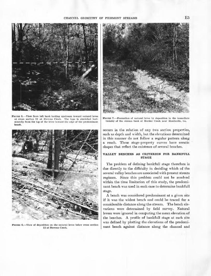
CHANNEL GEOMETRY OF PIEDMONT STREAMS E5
FIGURE 5. View from left bank looking upstream toward natural levee at cross section 11 at Stevens Creek. The tape is stretched hori zontally from the top of the levee toward the edge of the predominant bench.
- V-9^
FIGURE 6. View of deposition on the natural levee below cross section 11 at Stevens Creek.
t*~«urfe ^
m^ ' ;>-'SWf i
>^5si^:^?l*s^^^f':^i^fs&efcFIGURE 7. Formation of natural levee by deposition in the immediate
vicinity of the stream bank at Murder Creek near Monticello, Ga.
occurs in the relation of any two section properties, such as depth and width, but the elevations determined in this manner do not follow a regular pattern along a reach. These stage-property curves have erratic shapes that reflect the existence of several benches.
VALLEY BENCHES AS CRITERION FOR BANKFULLSTAGE
The problem of defining bankfull stage therefore is due directly to the difficulty in deciding which of the several valley benches are associated with present stream regimen. Since this problem could not be resolved within the time limitation of this study, the predomi nant bench was used in each case to determine bankfull stage.
A bench was considered predominant at a given site if it was the widest bench and could be traced for a considerable distance along the stream. The bench ele vations were determined by field survey. Natural levees were ignored in computing the mean elevation of the benches. A profile of bankfull stage at each site was defined by plotting the elevations of the predomi nant bench against distance along the channel and

E6 PHYSIOGRAPHIC AND HYDRAULIC STUDIES OF RIVERS
CROSS SECTIONS
46 8 10 12 14 16 18 20
DISTANCE DOWNSTREAM FROM CROSS SECTION 1, IN HUNDRED FEET
FIGUBB 8. Profiles of mean annual flood stage and various bench levels for Stevens Creek.
22 24
fitting the points with a line parallel to the known water-surface profile at about this stage.
When bankf ull stages so defined were plotted against distance along the channel, discontinuities were evident where there were major changes in the slope of the channel bed. This is illustrated in figure 8 by the pro files of benches 2 and 3 along Stevens Creek. In this instance benches 2 and 3 are clearly predominant in the respective upstream and downstream reaches. It should be noted that a higher and lower bench are identifiable but not prominent enough that either could be associated with bankfull stage. There is a drop of about 3 feet between the predominant benches where the slope of the channel bed flattens. Because the bench elevations appear to be associated with the slope of the channel, reaches were subdivided into lengths of rea sonably constant slope.
At Murder Creek two benches of about equal width
exist, and two equally valid bankfull profiles were determined. The two benches are indicated in figure 9. The water-surface profile existing at the higher bench level was much steeper than the water-surface profile at the level of the lower bench. The two benches are thus associated with different slopes an unusual occurrence where a section control is effective up to an extreme stage.
PRESENTATION OF DATA
Data corresponding to the mean annual flood and the various bench levels at the 34 stream sites are listed in table 3. The definition and source of the data in each numbered column in the table are given below: 1. The numbers corresponding to the various bench
levels in the valley reach. Bench levels are num bered from highest to lowest in the manner il lustrated in figures 2,4 and 8.

CHANNEL GEOMETRY OF PIEDMONT STREAMS E7
FIGURE 9. Photograph indicating two prominent benches at MurderCreek.
2. The discharge corresponding to the various bench levels as determined from the stage-discharge relationship.
3. The recurrence interval of the discharges in column 2 determined from an analysis of gaging-station records for sites 1-19 and from a regional flood- frequency analysis for sites 20-34.
4. The slope of the water surface for the particular bench level.
5. The mean depth, determined as the difference be tween the stage corresponding to the average bench elevation and the stage corresponding to the mean elevation of the channel bed.
6. The number of cross sections used to define the char acteristics of the reach. The highest and lowest benches were seldom identifiable throughout a reach.
7. The relative size of the benches at a given site are shown by numbers from 1 to 3. Number 1 indi cates the predominant bench; number 2, a promi nent but narrower bench; and number 3, a lesser bench.
8. The discharge corresponding to the,mean annual flood, determined from the information on flood frequency described for column 3.
9. The depth of the mean annual flood, determined as the difference between the stage of the mean an nual flood (from the stage-discharge relationship) and the stage corresponding to the mean elevation of the channel bed. An average value of the reach is listed.
TABLE 3. Data corresponding to the mean annual flood and various bench levels for streams in the Piedmont
Bench level
Site
1
2____. _ ._ _
3___________.
4__ _ ___ _
5__ __________
6___ ___ _
7__ __ _______
1
Bench (highest
to lowest)
12 3 12 3 4 12 3 4 12 3 12 3 4 12 3 12
2
Q(cfs)
890760 620
7,7006,600 5,050 1,950 5,9504,500 3, 450 1,660
2,000 580
2,0001, 300 1, 240
630 3,7003, 170 2,900 7,5004,200
3
Recurrence interval (years)
2.902. 33 1.90 2.902. 18 1.82 1. 10 2. 301.65 1. 38 1. 12
23. 1 1. 559.72.55 2. 33 1. 14 5. 23. 0 2. 33
12. 23. 5
4
Slope (ft per ft)
0. 0039. 0039 . 0039 .0023.0017 . 0009 . 0007 . 00068. 00078 . 00085 . 00052
. 0044
.0018
. 0017
. 0018
. 0028
. 0040
. 00088
. 00068
.0012
.0012
5
Mean depth (feet) (D b}
5. 14.6 3.6
12. 610.7 8.6 6.7
11.911. 1 9.5 7.6
12. 06. 1 4.48. 25.9 5.6 4. 1
12.410. 9 11. 118.813. 5
6
Identifiable at sections
1-84-8 2-3 1, 2, 4, 6, 81-4 1-113,7,9 1, 5-81-4, 6-9 4-8 1-2, 6-8 5-6,81-4, 6-8 1-4, 7-8 4,6-71-5 6-97-8 2-3, 6-91-5 6-11 4, 9, 121-12
7
Relative size
12 3 23 1 3 21 2 3 32 2 31 1 3 21 1 31
8
QMAF(cfs)
760
6, 400
6, 000
870 870
1, 240 1, 240
2,900 2,900
3, 500
9
' Mean depth (feet) (£>/>
4.
9.
12.
4. 4.
5. 5.
10. 11.
9,
Mean annual flood
3. 2

E8 PHYSIOGRAPHIC AND HYDRAULIC STUDIES OF RIVERS
TABLE 3. Data corresponding to the mean annual flood and various bench levels for streams in the Piedmont Continued
Bench level
Site
8____ __9---_--------
10_. ____-__._
!!___ _ _ _ .
12___ _ _____
13__---_- -__
14_ __ _
15___ _ ___ -
16_-_- _______
17-_- __ _-_
18____- -----
1Q
20-------- __21_____--___.22_ __ _ __23-__ __ __24_ _25__ _____ ..26___ ____ .27--_ ____ .28----------29.- __ . . .30_ __ ._- .31___ __ . _32___ _ _ __ _33_._ . ._. _34__ _________
1
Bench (highest
to lowest)
11 2 3 1 2 3 1 2 1 2 3 1 2 3 4 1 2 3 1 2 3 4 1 2 3 1 2 1 2 1 2
2
Q(cfs)
8,350 5,850 3, 780 2, 570
12, 300 7, 000 4,480 7, 400 4, 160 5,700 2,500 2,020
10, 200 6,900 5,400 2,560 1, 150
700 185
10, 900 5,200 1,580 1, 150 2,350 1,250
575 2, 170 1,040 8,000 2,350
12, 300 7,750 1, 120 6, 100 4,250 9, 100
14, 300 465 370 410
1, 150 320
3,500 310 300
.345 2,650
3
Recurrence interval (years)
2.60 4. 5 2.65 1.75
23.0 3.0 1. 45
23 6. 5 2.45 1. 19 1. 08 1. 75 1.28 1. 16 1.04
14.0 5.3 1. 24
90.0 13.7 3.20 1.80 2. 10 1. 10 1. 01 3. 90 1. 32 6.0 1. 09 2. 40 1. 15 2. 9 4.5 2. 5 2. 6 4.0 7.5
10. 0 1.8 2. 2 1. 01 48 5. 2 2.0 1. 05 1. 71
4
Slope (ft per ft)
.0014
. 0007
. 0007
. 00045
. 00047
. 00060
. 0017
.0019
. 00044
. 00030
. 00020 . 00043 . 00038 . 00025 . 00026 .0150 .0090 .0120 .0034 .0044 .0042 .0019 . 0004 . 00042 . 00048 . 00086 . 00086 . 0021 .0031 . 00054 . 00062 . 0023 .0018 .003 .0011 . 00060 .0087 .0150 .0035 .0017 . 00046 .0014 . 0059 . 0067 . 00075 .0058
5
Mean depth (feet) (£>&)
9.3 14.0 10.4 7.7
17.8 12.4 11. 5 14 1 8.8
16. 8 9.8 8.4
16. 4 14.6 15. 1 12. 1 5.8 4.3 2.3 8.4 5.6 4.6 3. 7
10.4 7.9 5.9 9.9 6.4 9.3 4. 5
17. 8 12.5
6. 5 10.4 7. 1
11.9 13.2 4 5 2.6 4.6 6.4 4.7
10.4 2. 7 3.2 42 8. 0
6
Identifiable at sections
3-9 1-2, 8-10 1-17 1,4,6, 10-12- 1,3-5,8,13 1-4, 5-13 5,8 2,4-5,7 1-11 1,3,5,8 2-6, 8 1-2, 4, 6-7 4-6, 8-11 1-6 8-11 1-3, 5,7, 9-11 3-5 6-8 3, 5-7 1, 9-10 1-4 1-3 8-10 1-6, 11 1-11 1-3, 5 1-7, 9 1-7 1-2, 8-9 2-4, 8-9 1-2, 4-5, 7-9 1-9 1-4 1-2 1-2 1-2 1-2 1-2 1-21-21-21-2 1-2 1-51-3 1-31-4
7
Relative size
1 2 1 3 2 1 3 2 1 3 1 3 3 1 1 3 1 1 3 2 1 3 1 2 1 3 2 1 1 3 2 1 1 1 1 1 1 1 1 1 1 1 1 1 1 1 1
Mean annual flood
8
QMAF (cfs)
7, 800
3,300
6, 270
2,300
5, 500
12, 500 12, 500
380 380
1,350
1,350
2,560
1,700 5,000
12, 200 1,020 4,500 4, 150 8, 750
11, 000 270 190 500
1,220 1,300 2,500
210 340
1,400 3,300
9
Mean depth (feet) (£/)
9.0
10.0
11.8
6.8
16.4
16. 118. 3
2.7 3.3
3.9
4.6
10.7
7.8 7.4
17. 5 6.2 8.7 7.0
11.7 12.0 2.7 2. 2 4.9 7.0 6.6 8.2 2. 1 3. 5 6.6 9.5
FREQUENCY OF BANKFULL DISCHARGE
Wolman and Leopold (1957) found that with only a few exceptions the frequency of overbank flooding was remarkably uniform on many small and large rivers. Their study indicates that many flood plains are subject to inundation at approximately yearly in tervals ; that is, the recurrence interval of bankfull stage is between 1 and 2 years. The uniformity of the rela tion between the channel and flood plain was attributed to the lateral migration of the channel across the flood
plain with no change in width. However, there is some implication in their data (p. 88) that on streams with steep slopes, the recurrence interval of bankfull stage may be quite high.
Inspection of table 3 of this report indicates much the same tendency, if the elevation of the predominant bench is considered to be bankfull stage. Generally on streams of relatively mild slope, the recurrence interval of bankfull stage lies bet\veen 1 and 2 years. The re currence interval tends to increase with steepening slope.

CHANNEL GEOMETRY OF PIEDMONT STREAMS E9
Some of the lower benches on these steeper streams have recurrence intervals between 1 and 2 years. It is doubt ful, however, that these benches can be considered the "flood plains," because these lower benches are not prominent and the streams do not meander and aggrade or degrade rapidly in this region.
THE EFFECT OF SLOPE
The effect of channel slope on the character of the benches and the frequency of their inundation is illus trated in figure 10. This graph which is based on data for the 34 reaches as given in table 3 shows the relation between bankf ull depth, the depth of mean annual flood, and slope. The data for streams on which the higher bench was predominant tend to plot to the r^ght of the equal depth line, and data for streams on which a lower bench was predominant plot to the left. The mean an nual flood on streams having steep slopes is contained within the channel, but on streams of mild slope it covers the predominant bench to a considerable depth.
The regression equation which expresses the relation of depth of mean annual flood (Df), bankful depth, (/>(,), and slope, (&), is:
n _ D (1)
The standard error is 12 percent and the regression co efficients are significant to the 0.001 level. The data for the predominant benches are compared with equation 1 in figure 11. The data based on extensive surveys at the gaging-station sites display less scatter than the data for the supplementary sites. This difference emphasizes the accuracy needed in determining the predominant bench and thus the bankf ull stage.
Stream slope appears to play an important role in determining the elevation of valley benches. Streams having steep slopes are deeply entrenched in the valley floor and, as compared with streams of mild slope, otter a greater capacity in the main channel for water con veyance. The character of the bed material also varies with slope and offers more resistance to the lateral mi gration of stream channels where the slope is steep. It thus appears that the importance of deposition as an agent in the formation of flood plains may be related to stream slope.
50
-.10
5 10
BANKFULL DEPTH, IN FEET
50
FIGUKE 10. Relation of bankfull depth to depth of mean annual flood for Piedmont streams.
afar
Gaging station sites
Supplement sites
o.oooi 0.0005 0.001 0.005
SLOPE (S), IN FEET PER FEET
0.01 0.05
FIGURE 11. Comparison of the data for 34 sites in the Piedmont with the graph of equation 1.

E10 PHYSIOGRAPHIC AND HYDRAULIC STUDIES OF RIVERS
VARIATION OF WATER SURFACE SLOPE WITH DEPTH
The water surface slope as used in this report is for bankfull stage. It is recognized that the slope of the water surface in a particular reach will vary with an increase in depth or discharge, as the pools and riffles which control low water flows are no longer individually effective. A comparison of the slope at low stage, and at bankfull stage, for the 34 reaches is given in figure 12. The plot indicates that the slope at low stage may be considerably greater or less than the slope at bankfull stage, if the channel slope is less than 0.002 ft per ft. On streams of greater slope, the low water slope may be used in lieu of the slope at bankfull stage in the ap-
0.05
o.oooi0.0001 0.0005 0.001 0.005 0.01 0.05
SLOPE AT LOW-WATER STAGE, IN FEET PER FEET
FIGDRE 12. Relationship between water surface slope at low stage and at bankfull stage. Solid dot, data from table 1 ; open dot, data from table 2.
plication of equation 1. On any stream the two slopes tend to converge as the length of the reach increases.
SUMMARY AND CONCLUSIONS
A complex system of benches and natural levees exists along stream channels in the Piedmont province. At a given site, several benches at different elevations are sub ject to flooding at recurrence intervals of less than 50 years. At most sites the active flood plain associated with the present stream regime cannot be distinguished in a survey of the stream channel.
The slope of the channel appears to be a major factor in determining the character of the benches. The mean annual flood is contained within the channel on streams of steep slope, but may inundate the highest bench to a considerable depth on streams of mild slope.
The depth of flow corresponding to the mean annual flood has been related to bankfull depth and the slope of the water surface. Bankfull depth was defined by the average elevation of the widest bench which could be traced along a considerable reach of stream channel.o
The consistency of this relation for the 34 study sites in the Piedmont demonstrates that the elevation and slope of valley benches are significantly related to the frequency of flood discharge. This relationship should prove useful in flood plain zoning studies and in estab lishing the correlation between stage and discharge for ungaged streams in the Piedmont.
REFERENCES CITED
Lobeck, A. K., 1939, Geomorphology: 1st ed., New York andLondon, McGraw-Hill Book Co., 731 p.
Wolman, M. G., and Leopold, L. B., 1957, River flood plains;some observations on their formation: U.S. Geol. Survey Prof.Paper 282-C, 22 p.
Wolman, M. G., 1955, The natural channel of Brandywine Creek,Pennsylvania: U.S. Geol Survey Prof. Paper 271, 56 p.
U.S. GOVERNMENT PRINTING OFFICE : 1964 O - 717-122


![[10] Channel Geometry](https://img.pdfslide.us/doc/110x75/55cf8d215503462b1392452b/10-channel-geometry.jpg)