Embed Size (px)
Citation preview
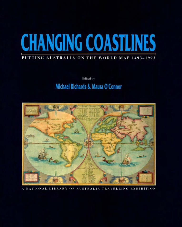
CHANGING COASTLINES P U T T I N G A U S T R A L I A ON T H E W O R L D MAP 1943-1993
Edited by
Michael Richards & Maura O'Connor
A NATIONAL LIBRARY OF AUSTRALIA TRAVELLING EXHIBITON
CHANGING COASTLINES PUTTING A U S T R A L I A ON T H E W O R L D M A P 1493-1993
Edited by
Michael Richards & Maura O'Connor
National Library of Australia Canberra
1993
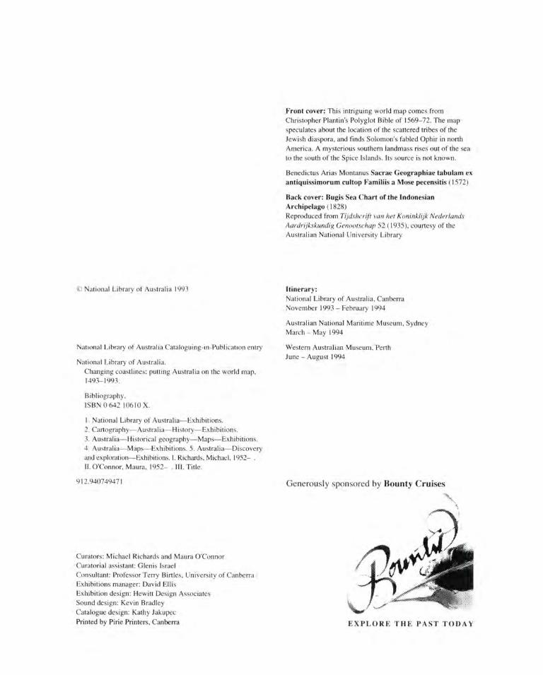
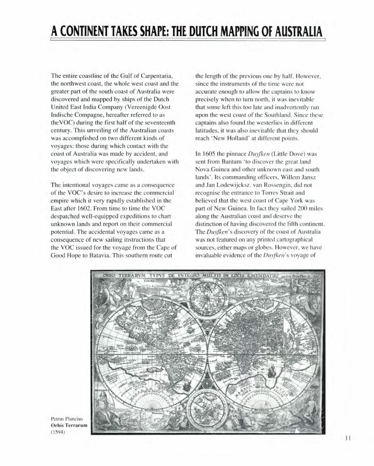
Front cover: This intriguing world map comes from Christopher Plantin's Polyglot Bible of 1569-72. The map speculates about the location of the scattered tribes of the Jewish diaspora, and finds Solomon's fabled Ophir in north America. A mysterious southern landmass rises out of the sea to the south of the Spice Islands. Its source is not known.
Benedictus Arias Montanus Sacrae Geographiae tabulam ex antiquissimorum cultop Familiis a Mose pecensitis (1572)
Back cover: Bugis Sea Chart of the Indonesian Archipelago (1828) Reproduced from Tijdshcrift van het Koninklijk Nederlands Aardrijkskundig Genootschap 52 (1935), courtesy of the Australian National University Library
© National Library of Australia 1993
National Library of Australia Cataloguing-in-Publication entry
National Library of Australia. Changing coastlines: putting Australia on the world map, 1493-1993.
Bibliography. ISBN 0 642 10610 X.
1. National Library of Australia—Exhibitions. 2. Cartography—Australia—History—Exhibitions. 3. Australia—Historical geography—Maps—Exhibitions. 4. Australia—Maps—Exhibitions. 5. Australia—Discovery and exploration—Exhibitions. I. Richards, Michael, 1952- . II. O'Connor, Maura, 1952- . III. Title.
912.940749471
Itinerary: National Library of Australia, Canberra November 1993 - February 1994
Australian National Maritime Museum, Sydney March-May 1994
Western Australian Museum, Perth June - August 1994
Generously sponsored by Bounty Cruises
Curators: Michael Richards and Maura O'Connor Curatorial assistant: Glenis Israel Consultant: Professor Terry Birtles, University of Canberra Exhibitions manager: David Ellis Exhibition design: Hewitt Design Associates Sound design: Kevin Bradley Catalogue design: Kathy Jakupec Printed by Pirie Printers, Canberra EXPLORE THE PAST TODAY
CONTENTS
Changing Coastlines 5 Michael Richards and Maura O'Connor
Arabic Navigational Texts 7 Gerald R. Tibbetts
A Continent Takes Shape: 11 The Dutch Mapping of Australia Giinter Schilder
Asian Knowledge of the 17 Australian Coast C.C. Macknight
British Charting of Australian Waters 20 T.M. Perry
Beach Maps 24 Andrew D. Short
Further Reading 26
Checklist 27
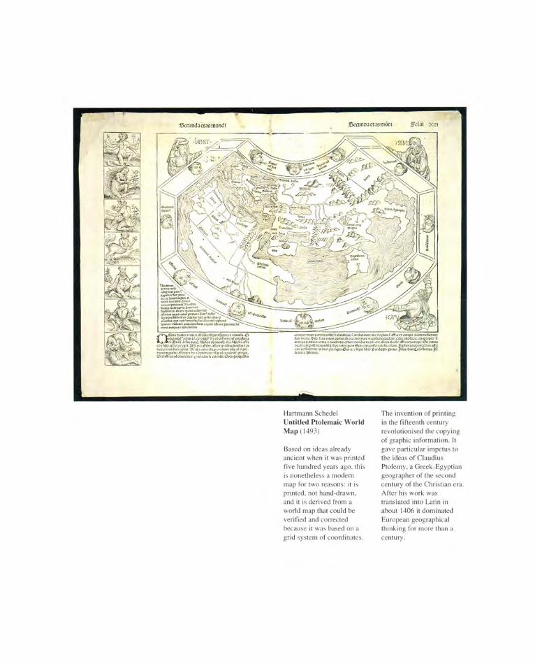
Hartmann Schedel Untitled Ptolemaic World Map (1493)
Based on ideas already ancient when it was printed five hundred years ago. this is nonetheless a modern map for two reasons: it is printed, not hand-drawn, and it is derived from a world map that could he verified and corrected because it was based on a grid system of coordinates.
The invention of printing in the fifteenth century revolutionised the copying of graphic information. It gave particular impetus to the ideas of Claudius Ptolemy, a Greek-Egyptian geographer of the second century of the Christian era. After his work was translated into Latin in about 1406 it dominated European geographical thinking for more than a century.
CHANGING COASTLINES
As mediators between an inner mental world and an outer physical one, maps are fundamental tools helping the human mind make sense of its universe at various scales. Moreover, they are undoubtedly one of the oldest forms of human communication ... Mapping, like painting, precedes both written language and systems involving number, and though maps did not become everyday objects in many areas of the world until the European Renaissance, there have been relatively few mapless societies in the world at large.
J.B. Harley, The History of Cartography, Volume I (1987), p.1
Most histories of the mapping of Australia tell a story of white navigators and explorers piecing together a more or less accurate picture of what Australia really looks like. Much has been written, often with great passion and scholarly thoroughness, in an attempt to establish who were the first Europeans to visit and map these shores. The navigators are usually presented in a heroic mould, Captain James Cook being the archetypal figure. Often, the story is told to validate one particular European nation's contribution to the discovery and settlement of Australia. Changing Coastlines takes a different approach, in line with one of the most interesting trends in current writing about cartographic history. The exhibition argues that particular maps are important, not simply because they contained information new to Europe, but also because of their impact on the course of history, and for what they can tell us today about the perception of Australia in the minds of those who created and used them.
Changing Coastlines reminds us that Australia has always been linked to Asia. Nowhere is this more apparent than in cartographic history. Europeans came to Asia, and hence Australia, simply because of the wealth and vast extent of Asian trade. Frequently they relied on Arab and other Asian pilots and their geographical knowledge, and often on Asian crews as well. Australia was investigated only inasmuch as it was on the edge of the bustling ports, the emporiums and the fabulous spice islands of Southeast Asia. Most who looked concluded that the southern continent was of little significance
compared to the potential wealth that war, trade and piracy could win to its north. Scraps of geographical knowledge about Australia, often picked up by accident as Spain, Portugal, England and the Netherlands vied for trade and imperial power, were not added to for centuries.
The booming Chinese economy of the eighteenth century and the loss of her American colonies forced Britain to concentrate its trade in Asia from the 1780s, soon after the British Admiralty had pretty well solved the question of Terra Australis—largely, but by no means entirely, through the first two voyages of Cook. The settlement at Botany Bay, the birthplace of white Australia, was the result. Maps chart the story, just as subsequent mapping done out of Sydney tells of the pattern of Australian trade and commerce as much as the position of reefs and wrecks.
To us it matters little whether or not Portuguese mariners visited Australia before the Dutch, as some believe. Maps are tools, made to tell people about places. They may or may not be meant to guide actual travel: many are simply ways of locating people in a 'known world'. Early geographic, and perhaps cartographic, knowledge of Australia in Western Europe kept in secrecy can have had only limited use and therefore significance. This is not to deny the fascination of early travel and the reports of the men and women who braved the seas, the unknown lands and the uncertain hospitality of far-distant people, in order to discover the world. The word 'discovery' has become unfashionable in this context, but used in its eighteenth-century meaning, which is simply to see, to find for oneself, it is a fine word and should not be driven from our vocabulary by the demands of political correctness. But the great interest aroused in our media by reports of ancient ships, mahogany or otherwise, and by other alleged evidence of early European visits to Australian shores, is sometimes highly suspect. Above all, it denies the achievement of Aboriginal people, who were the first people to find and settle Australia.
5
The generous support of Bounty Cruises and the Bruce and Joy Reid Foundation sponsoring the exhibition is gratefully acknowledged. The exhibition has also benefited from the willing support of lenders and advisors. We wish to thank the State Library of New South Wales, the Royal Australian Navy Hydrographic Office, the National Museum of Australia, the Museum of Victoria and an anonymous lender approached through the good offices of Hordern House Rare Books Pty Ltd, among the former, and Professor Terry Birtles of the University of Canberra among the latter. We are grateful also to the distinguished contributors of brief essays to this catalogue. An exhibition such as this can only skim the surface of a huge subject with its own vast literature. We offer a brief list of further reading, and urge you to consult your local library for more references.
Michael Richards, Exhibitions Curator, National Library of Australia Maura O'Connor, Map Curator, National Library of Australia
THE MAP COLLECTION OF THE NATIONAL LIBRARY OF
AUSTRALIA
Since 1901, donations and purchases of historical Australian maps together with a legal deposit arrangement for all Australian mapping have ensured that the National Library of Australia's Map Collection is the largest and most comprehensive in the country. With an eye for the rare and unusual, collectors such as E.A. Petherick, Sir John Ferguson, Sir Rex Nan Kivell and R.V. Tooley ensured that significant maps such as the rare 1659 Doncker Sea Atlas and early Australian real estate sales plans were included in their collections, now in the Library. Consequently, the collection is rich in every aspect of the mapping of the Australian continent, ranging from early sixteenth-century concepts of an unknown Australia and subsequent discovery and exploration to detailed cadastral mapping of her cities, towns and countryside.
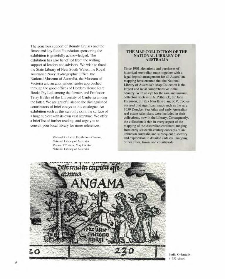
India Orientalis (1535) detail
6
ARABIC NAVIGATIONAL TEXTS
It is important to stress the part played by local navigators in the opening up of the Indian Ocean. Centuries before the European trading ventures appeared on the scene, there was considerable trading activity in the Ocean. All peoples living on the edge of the Ocean were sailors and the larger political and social groups probably produced naval and commercial fleets which sailed over a considerable portion of the Ocean's surface. The Arabs in particular show in their navigational works, the detail which they knew of the whole Ocean, and classical Arabic geographical texts show the coverage which their shipping made over this part of the world. There is evidence that other peoples such as Indians, Malays and, to some extent, the Chinese used similar methods of navigation. In fact, the same methods may have been common to all indigenous peoples of the Ocean. Also the use of these methods may go back to quite early times. By the middle of the ninth century AD, Arab shipping is said to have reached Korea—and these ships may have been sailing in the same tradition as the Persian Gulf ships which carried wood from the early Indus civilisation in the early centuries AD.
Arab navigation was really based on an oral tradition; the surviving manuscripts give us a description of it going back at least to the twelfth century AD. The basics of navigation were passed on from generation to generation mainly in the form of simple poetry. It was only in the fifteenth century that it was written down, mainly to satisfy the literary aspirations of one individual— Ahmad ibn Majid—and several manuscripts survive containing works by him. Short passages in poetry in various of his manuscripts sometimes deal with certain aspects of navigation. However, the longest work by him (al-Fawa'id fi us ul al-bahr wa'l-qawa'id) is a sort of navigational encyclopaedia, written in prose, and attempting to cover all aspects of this craft. Ibn Majid was followed in the early sixteenth century by Sulaiman al-Mahri whose work was logically thought out and attempts to give co-ordinates for
all the ports of the Indian Ocean in the form of Pole star altitudes and bearings ('Umdat al-Mahriya fi dabt al-'ilm al-bahriya and Minhaj al-fakhir fi 'ilm al-bahr al-zakhir). It is therefore possible for us to produce charts from the information given, although there is no evidence that the Arabs themselves produced such charts. They seem to have gone no further than listing ports with the star altitudes and bearings which could easily be remembered and passed on to the next generation of navigators. The coverage is very detailed for most of the Indian Ocean, but tails off south of the equator in East Africa and beyond Malacca in Asia. Lesser detail takes one on to the end of Java and to China (Canton). Beyond that are a few more general references including mention of the Banda Islands and Moluccas. The Lesser Sunda Isles are also mentioned, but inaccurately. As they are all known as the Timor Islands it is difficult to know just how far the Arab information reached in this direction.
Lack of longitude values as a second 'co-ordinate' because of the difficulty in establishing a prime meridian was probably the real reason why marine charts did not develop in this system of navigation together with the use of memory rather than the written record for communication of information. A chart, after all, is a documentary record devised to save memorising a large amount of data: the Arabs preferred to memorise.
The information given about any place in these texts is minimal. The aim of the text was the practical one of enabling the pilot (mu'allim) to reach one place from another, either the next port along the coast or to cover a trade route like reaching Malacca from Aden. This means that some form of position location of important places must be given and the texts choose an equivalent for latitude (the altitude of the North pole above the horizon) and as the second 'co-ordinate' the compass bearing from any neighbouring place or places. Also given are
7
masafat or horizontal distances between points of equivalent Pole-star altitude—estimated rather haphazardly by a triangulation method involving an intermediate point with a known but different Pole star altitude. Other information like the appropriate times for setting out on certain voyages (mawasim) and places where one might expect to find certain types of fish, birds or maritime vegetation also appear in the text. The word mawasim (singular mawsim: the time for setting out) is now used commonly in the form 'monsoon' referring to the seasonal winds which are the real cause for setting out at those times.
A detailed knowledge of the heavens and the inter-relationship of bright stars and easily identifiable star groups is a most important qualification for a navigator. Also he must know the position of the heavens at certain times of the year and at any time of the night throughout the year. The sun was of no use to the navigator as its position varied from day to day in any one
locality and could easily be obscured by cloud. With the stars, only a small piece of clear sky was necessary to give the navigator sufficient clues to enable him to continue on his journey. The stars, in addition, gave him a calendar throughout the year and could be used as a clock by which to set the watches at night.
Thus we can see that this system of navigation was extremely complex, but based on extremely simple premises. All a navigator required beyond his own skill was a magnetic compass and a small instrument to measure the altitudes of stars above the horizon. This latter was measured in 'fingers', literally the width of the finger held at arm's length. Four fingers or a handbreadth was a very convenient measurement and normally this was represented by a small board used to standardise this handbreadth. By placing a knotted string through the board and holding a knot to the eye, the angle subtended by the board could be measured. Before the introduction of the
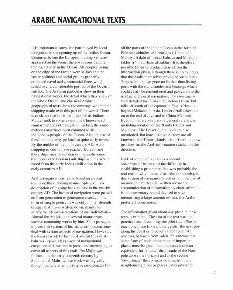
The Corsali Letter of 1516
Andrea Corsali reports to the Medici ruler of Florence, writing from Cochin, in Southern India. He travelled with a Portuguese expedition— south along the West African coast, round the Cape of Good Hope, and across the Indian Ocean—to make landfall at Goa. Goa and Cochin were outposts of the aggressive new empire
of Portugal. Corsali described a constellation of stars which he named the Cross. The constellation was already well known to the sailors who used the stars to navigate by, but it was Corsali's name which stuck, at least in the West. The Cross became a symbol of the lands of the South: this sketch is the first known drawing of the Southern Cross to be seen in Europe.
8
magnetic compass (about 1260 AD) it is possible that risings and settings of certain stars on the horizon would have been used to gauge the bearing. Thus if we look back to earlier times a voyage across the Indian Ocean could have been completed successfully without any instrument at all, relying entirely on the expertise of the navigator. Polynesian sailors have been navigating in a similar way in comparatively recent times and have despised European
methods of navigation. The Arabs however, after the coming of European ships into the Indian Ocean, neglected their traditional methods in favour of European ones in spite of the fact that they had finally committed them to writing. A few centuries later this ancient art had been completely forgotten.
Dr Gerald R. Tibbetts
THE QUALITIES OF A NAVIGATOR
It is advisable for the pilot to be a patient man in time of fatigue and capable of distinguishing between movement and haste, knowledgeable and learned in many things, steady and constant, gentle in his speech, just, never complaining of one man before another, steadfastly obeying his Lord, and fearing God. He should not anger the merchants over regulations except in such matters where they interrupt him in his duties or in matters pertaining to custom. He should bear things patiently and be of high ambition, patiently arbitrating among men, not busying himself in things which do not concern him, literate and of sound judgment. If he has not these qualities then he can never be the ideal navigator.
Know, oh seeker, that every man knows his own coast best; the Chinese, China; the people of Sofala, Sofala; the Indians. India; the people of Hijaz, the Hijaz; the Syrians, Syria; but the sea is not peculiar to each region and when you are out of sight of the coasts, you have only your own knowledge of the stars and guides to rely on. These are the same whether you are in your own district or in some other. The total of named stars is 1,025 and it is said that 28 are like al-Sunbula—and some have found fault in me about them, but I have not seen in all my travels among Arabs and non-Arabs anyone at this present time who can acquaint me with them. Concerning the knowledge of the sea and its islands, there may be found someone with better knowledge than mine, but regarding the stars and their use
as signs. I have not seen anyone at the present time, not among keen-eyed navigators. Clever is the man if this can be found in him when he has not been guided by my books at the beginning of his career and then increased in experience himself and received the help of God all his life. Such is he who has followed my results all his life and has never used any other.
Know that navigators are of three types. The first is the navigator who comes and goes, sometimes safely and sometimes not, making good and erroneous decisions. This is the lowest form of navigator. The second type, is the navigator, well-known by people for his excellent knowledge, cleverness and skill in every place to which he travels; he collects experience of it, but is not known after his death. The third type of navigator, who is the highest of all, is he who is well known for his excellent knowledge and his great attainments from whom none of the problems of the sea are hidden and who writes books which can be of use during his life and which people can use after his death.
Extract from Ahmad ibn Majid's Kitab al-Fawa'id, translated by Gerald R. Tibbetts. Reproduced with permission from his Arab Navigation in the Indian Ocean before the Coming of the Portuguese (London: Royal Asiatic Society, 1971)
9
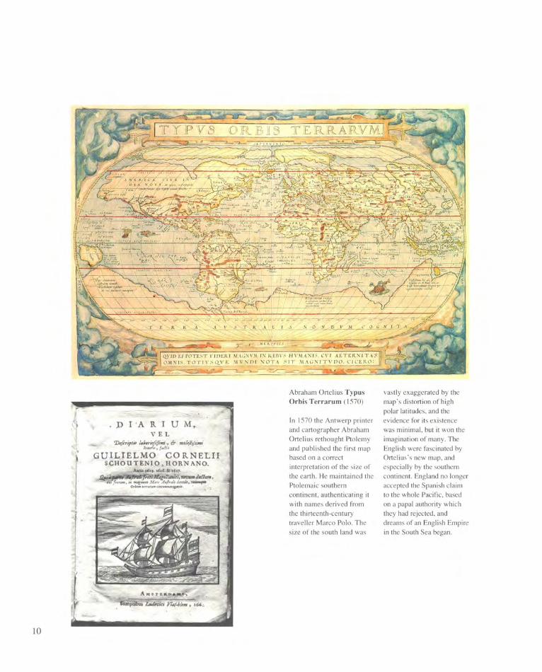
Abraham Ortelius Typus Orbis Terrarum (1570)
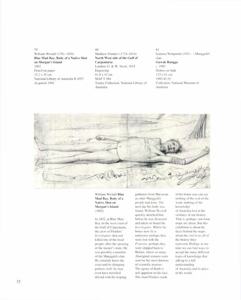
In 1570 the Antwerp printer and cartographer Abraham Ortelius rethought Ptolemy and published the first map based on a correct interpretation of the size of the earth. He maintained the Ptolemaic southern continent, authenticating it with names derived from the thirteenth-century traveller Marco Polo. The size of the south land was
vastly exaggerated by the map's distortion of high polar latitudes, and the evidence for its existence was minimal, but it won the imagination of many. The English were fascinated by Ortelius's new map, and especially by the southern continent. England no longer accepted the Spanish claim to the whole Pacific, based on a papal authority which they had rejected, and dreams of an English Empire in the South Sea began.
10
The entire coastline of the Gulf of Carpentaria, the northwest coast, the whole west coast and the greater part of the south coast of Australia were discovered and mapped by ships of the Dutch United East India Company (Vereenigde Oost Indische Compagne, hereafter referred to as the VOC) during the first half of the seventeenth century. This unveiling of the Australian coasts was accomplished on two different kinds of voyages: those during which contact with the coast of Australia was made by accident, and voyages which were specifically undertaken with the object of discovering new lands.
The intentional voyages came as a consequence of the VOC's desire to increase the commercial empire which it very rapidly established in the East after 1602. From time to time the VOC despatched well-equipped expeditions to chart unknown lands and report on their commercial potential. The accidental voyages came as a consequence of new sailing instructions that the VOC issued for the voyage from the Cape of Good Hope to Batavia. This southern route cut
the length of the previous one by half. However, since the instruments of the time were not accurate enough to allow the captains to know precisely when to turn north, it was inevitable that some left this too late and inadvertently ran upon the west coast of the Southland. Since these captains also found the westerlies in different latitudes, it was also inevitable that they should reach 'New Holland' at different points.
In 1605 the pinnace Duyfken (Little Dove) was sent from Bantam 'to discover the great land Nova Guinea and other unknown east and south lands'. Its commanding officers, Willem Jansz and Jan Lodewijcksz. van Rossengin, did not recognise the entrance to Torres Strait and believed that the west coast of Cape York was part of New Guinea. In fact they sailed 200 miles along the Australian coast and deserve the distinction of having discovered the fifth continent. The Duyfken's discovery of the coast of Australia was not featured on any printed cartographical sources, either maps or globes. However, we have invaluable evidence of the Duyfken's voyage of
Petrus Plancius Orbis Terrarum (1594)
A CONTINENT TAKES SHAPE: THE DUTCH MAPPING OF AUSTRALIA
11
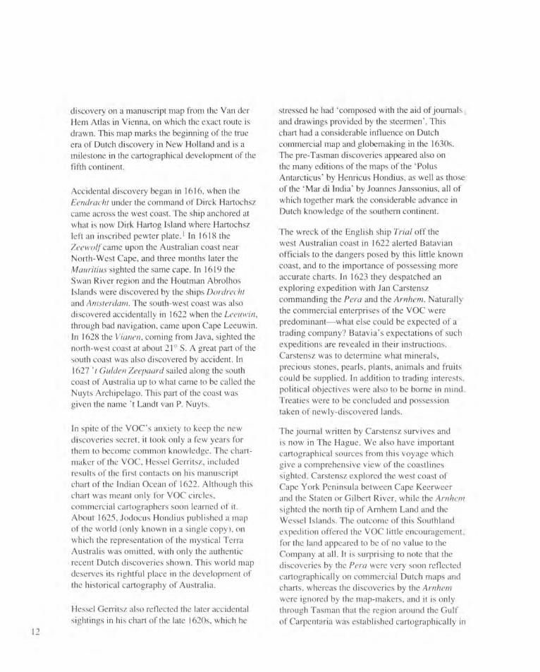
discovery on a manuscript map from the Van der Hem Atlas in Vienna, on which the exact route is drawn. This map marks the beginning of the true era of Dutch discovery in New Holland and is a milestone in the cartographical development of the fifth continent.
Accidental discovery began in 1616, when the Eendracht under the command of Dirck Hartochsz came across the west coast. The ship anchored at what is now Dirk Hartog Island where Hartochsz left an inscribed pewter plate. 1 In 1618 the Zeewolf came upon the Australian coast near North-West Cape, and three months later the Mauritius sighted the same cape. In 1619 the Swan River region and the Houtman Abrolhos Islands were discovered by the ships Dordrecht and Amsterdam. The south-west coast was also discovered accidentally in 1622 when the Leeuwin, through bad navigation, came upon Cape Leeuwin. In 1628 the Vianen, coming from Java, sighted the north-west coast at about 21° S. A great part of the south coast was also discovered by accident. In 1627 't Gulden Zeepaard sailed along the south coast of Australia up to what came to be called the Nuyts Archipelago. This part of the coast was given the name' t Landt van P. Nuyts.
In spite of the VOC's anxiety to keep the new discoveries secret, it took only a few years for them to become common knowledge. The chart-maker of the VOC, Hessel Gerritsz, included results of the first contacts on his manuscript chart of the Indian Ocean of 1622. Although this chart was meant only for VOC circles, commercial cartographers soon learned of it. About 1625, Jodocus Hondius published a map of the world (only known in a single copy), on which the representation of the mystical Terra Australis was omitted, with only the authentic recent Dutch discoveries shown. This world map deserves its rightful place in the development of the historical cartography of Australia.
Hessel Gerritsz also reflected the later accidental sightings in his chart of the late 1620s, which he
stressed he had 'composed with the aid of journals and drawings provided by the steermen'. This chart had a considerable influence on Dutch commercial map and globemaking in the 1630s. The pre-Tasman discoveries appeared also on the many editions of the maps of the 'Polus Antarcticus' by Henricus Hondius, as well as those of the 'Mar di India' by Joannes Janssonius, all of which together mark the considerable advance in Dutch knowledge of the southern continent.
The wreck of the English ship Trial off the west Australian coast in 1622 alerted Batavian officials to the dangers posed by this little known coast, and to the importance of possessing more accurate charts. In 1623 they despatched an exploring expedition with Jan Carstensz commanding the Pera and the Arnhem. Naturally the commercial enterprises of the VOC were predominant—what else could be expected of a trading company? Batavia's expectations of such expeditions are revealed in their instructions. Carstensz was to determine what minerals, precious stones, pearls, plants, animals and fruits could be supplied. In addition to trading interests, political objectives were also to be borne in mind. Treaties were to be concluded and possession taken of newly-discovered lands.
The journal written by Carstensz survives and is now in The Hague. We also have important cartographical sources from this voyage which give a comprehensive view of the coastlines sighted. Carstensz explored the west coast of Cape York Peninsula between Cape Keerweer and the Staten or Gilbert River, while the Arnhem sighted the north tip of Arnhem Land and the Wessel Islands. The outcome of this Southland expedition offered the VOC little encouragement, for the land appeared to be of no value to the Company at all. It is surprising to note that the discoveries by the Pera were very soon reflected cartographically on commercial Dutch maps and charts, whereas the discoveries by the Arnhem were ignored by the map-makers, and it is only through Tasman that the region around the Gulf of Carpentaria was established cartographically in
12
Hessel Gerritsz Discoveries around the West Coast of Australia (c. 1630)
a form which was then retained without alteration for the next 150 years.
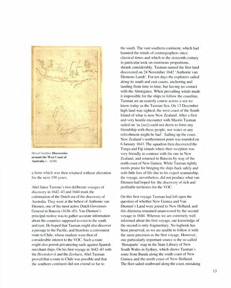
Abel Jansz Tasman's two deliberate voyages of discovery in 1642-43 and 1644 mark the culmination of the Dutch era of the discovery of Australia. They were at the behest of Anthonie van Diemen, one of the most active Dutch Governors General in Batavia (1636-45). Van Diemen's principal motive was to gather accurate information about the countries supposed to exist to the south and east. He hoped that Tasman might also discover a passage to the Pacific, and therefore a convenient route to Chile, whose markets were then of considerable interest to the VOC. Such a route might also permit privateering raids against Spanish merchant ships. On his first voyage in 1642-43 with the Heemskerck and the Zeehaen, Abel Tasman proved that a route to Chile was possible and that the southern continent did not extend so far to
the south. The vast southern continent, which had haunted the minds of cosmographers since classical times and which in the sixteenth century in particular took on enormous proportions, shrank considerably. Tasman named the first land discovered on 24 November 1642 'Anthonie van Diemens Landt'. For ten days the explorers sailed along its south and east coasts, anchoring and landing from time to time, but having no contact with the Aborigines. When prevailing winds made it impossible for the ships to follow the coastline, Tasman set an easterly course across a sea we know today as the Tasman Sea. On 13 December high land was sighted, the west coast of the South Island of what is now New Zealand. After a first and very hostile encounter with Maoris Tasman sailed on 'as [we] could not deem to form any friendship with these people, nor water or any refreshment might be had'. Sailing up the coast, New Zealand's northernmost point was rounded on 6 January 1643. The squadron then discovered the Tonga and Fiji islands where their reception was very friendly in contrast with the one in New Zealand, and returned to Batavia by way of the north coast of New Guinea. While Tasman rightly merits praise for bringing the ships back safely and with little loss of life due to his expert seamanship, the voyage, nevertheless, did not produce what van Diemen had hoped for: the discovery of rich and profitable territories for the VOC.
On this first voyage Tasman had left open the question of whether New Guinea and Van Diemen's Land were joined to New Holland, and this dilemma remained unanswered by the second voyage in 1644. Whereas we are extremely well informed about the first voyage, our knowledge of the second is only fragmentary. No logbook has been preserved, so we are unable to follow it with the same precision as the first voyage. However, one particularly important source is the so-called 'Bonaparte' map in the State Library of New South Wales in Sydney, which shows Tasman's route from Banda along the south coast of New Guinea and the north coast of New Holland. The fleet sailed southward along the coast, mistaking
13
Torres Strait for a bay, but 'no continuous channel between half-known Nova Guinea and the known land of the Eendracht or Willems territory ... was found, but [we] did find a great spacious bight or Gulf as the chart and journals dispatched herewith make plain'. This gulf (Gulf of Carpentaria) was followed further along the west coast, dropping anchor here and there, and in this way the entire north coast of the Southland was explored. The directors of the VOC were disappointed with the results of Tasman's two voyages and lost interest for the time being in further voyages of discovery. No further knowledge of the coastline was demanded beyond that which had been ascertained in the first half of the seventeenth century.
While thirty years passed by before the text of a journal of Tasman's voyages was published, the results of both voyages became known among circles outside the VOC through charts. As chart-maker to the Chamber of Amsterdam, Joan Blaeu had at his disposal the latest charts of voyages of discovery sent over from Batavia. Consequently, he was able to design new charts with this material at hand, or to revise existing ones. One of these revised charts was the wall map of the world which his father Willem Jansz published in 1619. It is the oldest printed map with the results of Tasman's voyages. In 1645-46 Joan Blaeu had the design of a great unknown southern continent, on the original copper-plates of 1619, hammered out and replaced by the discoveries made by Tasman and his predecessors. This map of the world is the earliest printed chart in which the name 'Nova Hollandia' represents Australia, the name 'Ant van Diemens lant' Tasmania and the name 'Zeelandia Nova' New Zealand. This map (the only known copy is in the Maritime Museum in Rotterdam) is the opening of a new stage in the cartographical representation of the fifth continent, one which in general remained unaltered until Captain Cook rang in a new era in cartography in 1770 with his discovery of the east coast.
After Tasman's voyages Dutch ships made landfall on the coast of New Holland in the seventeenth
century only by accident. There was, however, one exception: the expedition by Willem De Vlamingh in 1696-97. This was the last great Dutch voyage of discovery to New Holland and provided new information about the west coast. At the end of December 1696, De Vlamingh's fleet sighted Rottnest Island. A party explored the island and reported that 'there are no other animals than woodrats'. The Swan River area was explored, and the fleet then moved up the coast to North West Cape. Several landings were made in an attempt to make contact with the Aborigines, but these failed. At Dirk Hartog Island they found the pewter plate left in 1616. To commemorate his own visit, De Vlamingh left a pewter plate at the same spot.
It is surprising that De Vlamingh's voyage of discovery is reflected on only a few manuscript charts of the period. People were satisfied with the results of Tasman's and his predecessors' voyages. De Vlamingh's journal was filed in the VOC archives and more than fifty years went by before his findings were given wider publicity. In 1753 the sixth part of Van Keulen's Zee-Fakkal appeared, which shows the coasts, islands and ports of the Indies for the first time in print. This sea atlas contains a chart of New Holland based on De Vlamingh's voyage. De Vlamingh's expedition was followed by two smaller ones in 1705 and 1756, which produced similarly disappointing results. New Holland had nothing to offer which matched the VOC's commercial pattern. The VOC lost interest in the barren coasts of the fifth continent and deliberately gave up the idea of exploring any further.
Gunter Schilder Faculty of Geographical Sciences, University of Utrecht
1 As in seventeenth century England, the spelling of Dutch surnames varied at the time. Dirck Hartochsz is generally referred to in Australia today as Dirk Hartog (eds).
14
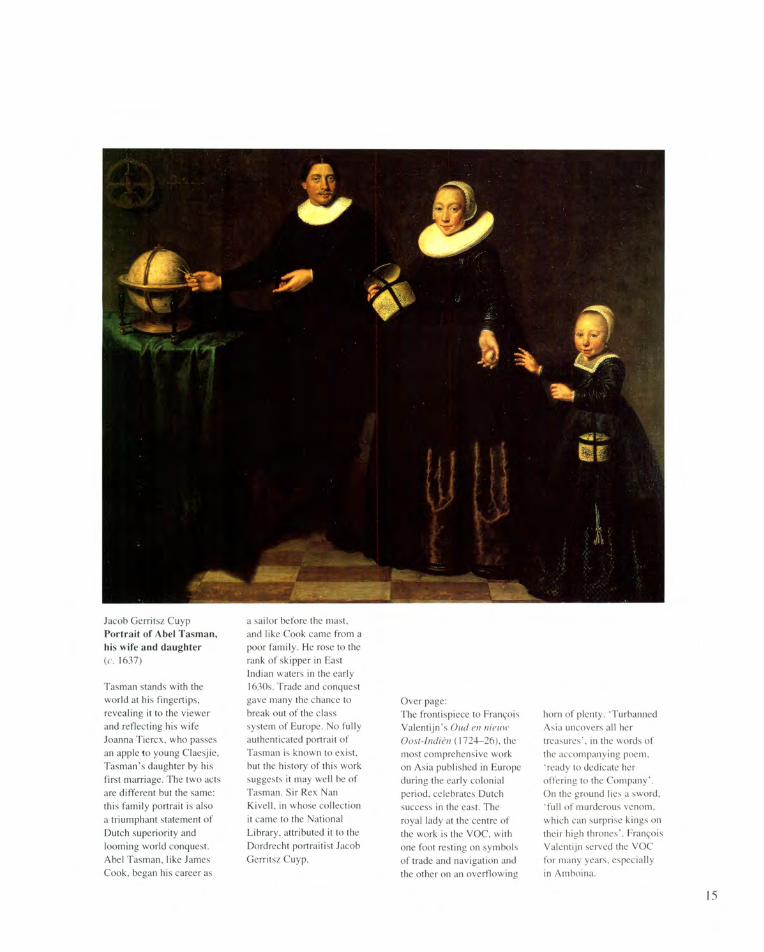
Jacob Gerritsz Cuyp Portrait of Abel Tasman, his wife and daughter (c. 1637)
Tasman stands with the world at his fingertips, revealing it to the viewer and reflecting his wife Joanna Tiercx, who passes an apple to young Claesjie, Tasman's daughter by his first marriage. The two acts are different but the same: this family portrait is also a triumphant statement of Dutch superiority and looming world conquest. Abel Tasman, like James Cook, began his career as
a sailor before the mast, and like Cook came from a poor family. He rose to the rank of skipper in East Indian waters in the early 1630s. Trade and conquest gave many the chance to break out of the class system of Europe. No fully authenticated portrait of Tasman is known to exist, but the history of this work suggests it may well be of Tasman. Sir Rex Nan Kivell, in whose collection it came to the National Library, attributed it to the Dordrecht portraitist Jacob Gerritsz Cuyp.
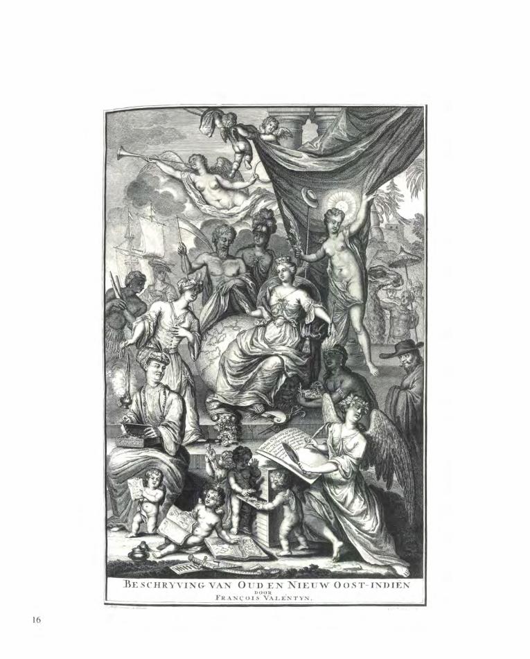
Over page: The frontispiece to Francois Valentijn's Oud en nieuw Oost-Indien (1724-26), the most comprehensive work on Asia published in Europe during the early colonial period, celebrates Dutch success in the east. The royal lady at the centre of the work is the VOC, with one foot resting on symbols of trade and navigation and the other on an overflowing
horn of plenty. 'Turbanned Asia uncovers all her treasures', in the words of the accompanying poem, 'ready to dedicate her offering to the Company'. On the ground lies a sword, 'full of murderous venom, which can surprise kings on their high thrones'. Francois Valentijn served the VOC for many years, especially in Amboina.
15
ASIAN KNOWLEDGE OF THE AUSTRALIAN COAST
The manuscript chart of the Duyfken's voyage in 1606 and the records of Torres' passage later in the same year through the strait that now bears his name comprise the earliest evidence for knowledge of the Australian continent in Asia, as well as in Europe. Despite some intriguing hints of early maps in Southeast Asia, none are known. The Mao K'un map which derives from Chinese contacts with South and Southeast Asian coasts in the early fifteenth century shows no detailed knowledge of the Indonesian archipelago, and nothing beyond.
There was no barrier to the knowledge of Europeans becoming known to Asians. The Verbiest Map of 1669 shows how quickly Dutch discoveries were made known in China. The transmission of information within the Indonesian archipelago was even swifter and in 1648 the Dutch East India Company provided Karaeng Pattingalloang, a leading political and intellectual figure in South Sulawesi, with the latest maps by Joan Blaeu, ordered directly from Amsterdam. These were followed in 1651 by a gigantic globe.
Both showed the results of Tasman's recent voyages to the coast of Australia. Even the best charts of the relatively meagre geographical discoveries on Martin van Delft's voyage of 1705 to Melville and Bathurst Islands and the Cobourg Peninsula on the mainland were 'improperly detained' in Macassar, where anyone may have seen or heard of them.
The accessibility of this knowledge needs to be kept in mind when seeking to explain the beginnings of the trepang industry along the Australian coast. Some years just before 1720, locally based boats began to bring into Macassar small quantities of commercially prepared trepang, that is dried beche-de-mer, sea cucumbers or sea slugs. The demand for these in China was relatively new, and Macassar quickly became—as it still remains—the major port in which to consolidate the product of innumerable processing sites on distant beaches ready for bulk loading onto junks going directly to China, or for trans-shipment through Batavia. Soon after 1720, the first of these local boats seems to have
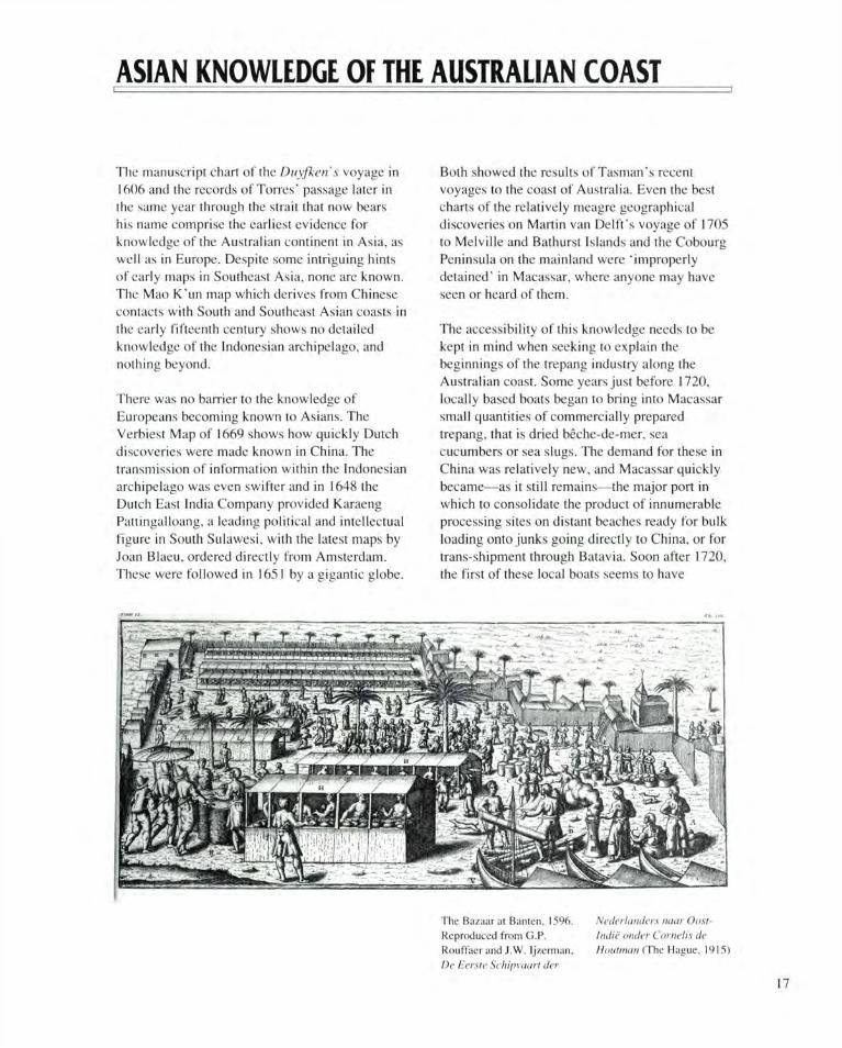
The Hazaar at Banten, 1596. Reproduced from G.P. Rouffaer and J.W. Ijzerman, De Eerste Schipvaart der
Nederlanders naar Oost-Indie onder Cornells de Houtman (The Hague, 1915)
17
extended their range to the north Australian coast, including the Kimberley coast and exactly that area dealt with in the charts from 1705. That is, after all, where the monsoon winds carry any craft coming round either end of Timor.
By the 1750s and 1760s, Europeans were aware of this annual fleet of small vessels coming down as far as the Gulf of Carpentaria, and in 1803 both Flinders off the north-east corner of Arnhem Land and Baudin on the Kimberley coast met groups of boats. These trepang fishermen were sophisticated and literate, but though they well understood the business of Flinders and later hydrographers, they seem not to have used charts themselves. Depending on the regular alternation of the monsoon and sailing close inshore for the most part, they relied on observation and accumulated knowledge, with a small compass for display and longer crossings. Some of this local knowledge is reflected in the names they bestowed, a few of which are still current. Bartalumba Bay on Groote Eylandt, for example, is named after the cliff—Batu Lompoa or Great Stone—on its western side. The last of these
trepangers came in 1906. Aborigines still remember them well and, in recent years, have re-established some family links.
The north coast of Australia formed a kind of southeastern boundary to the world of the Indonesian archipelago. This can be seen on a locally produced map, based on a European model, from 1828 (reproduced on the back cover). This awareness of the coast is unsurprising. From Cook onwards, almost every British hydrographic expedition working in north Australian waters called at ports in the archipelago. During the course of the nineteenth century, many Southeast Asians served on European vessels sailing around the coast. Asian pearlers were active from late in the century and Japanese boats were particularly active in the 1930s. The charts used by all these interests, right up to modern day boat people and traditional fishermen, are all based on surveys inspired and carried out by Europeans.
C.C. Macknight Australian National University
Opposite page: William Westall The English Company's Islands, Probasso, a Malay Chief (1803)
18
BRITISH CHARTING OF AUSTRALIAN WATERS
Before William Dampier, the first British sailor to sight any part of Australia, made a landfall on the Australian coast, the Dutch had established the position of the western part of the continent and roughly charted the north, west and south coasts of 'New Holland' from Cape York Peninsula to the head of the Great Australian Bight, and the southern part of Van Diemen's Land (now Tasmania). The compilers of charts showing the tracks of Abel Tasman's two voyages in 1642 and 1644 often sketched in conjectural coastlines linking the east coast of Van Diemen's Land with the north coast of New Guinea, and its west coast to that of Nuyts' Land (the southern part of New Holland) so suggesting that all were parts of a single continent.
Dampier visited the west coast twice: in 1688, when his ship Cygnet was careened near the entrance to King Sound, and in 1699, when he visited Shark Bay, the Dampier Archipelago and Lagrange Bay. Though Dampier added little to the charts of the west coast, his experiences there and off the north coast of New Guinea, where he found that New Britain was an island and not part of New Guinea, led him to two conclusions that had an important influence on later British thinking about New Holland. First, that the Dutch charts were not to be relied upon, and second, that New Holland itself might prove to be a group of islands separated by a passage whose entrance probably lay behind the islands off the north-west coast. He was, in fact, suspecting the existence of King Sound.
One consequence of Dampier's thinking was that when the British cartographer Aaron Arrowsmith compiled his 1798 chart of the Pacific Ocean he appears to have accepted for inclusion any discovery by a British navigator, but only those discoveries made by Dutch voyagers that had been confirmed by a second sighting. Cook's discovery of New South Wales, and Furneaux's charting of the south and east coasts of Van Diemen's Land were included in his chart, but Nuyts' Land and the west coast of Van Diemen's
Land, both of which had been sighted only once by the Dutch, were omitted. A second consequence was that the instructions issued to Matthew Flinders for his Investigator survey of the coast included directions to investigate openings in the coast that might lead into the interior or to a strait that might separate New Holland from New South Wales.
James Cook sailed westward from New Zealand in 1770 hoping to make a landfall on the east coast of Van Diemen's Land about where Tasman had left it in 1642. He was carried too far to the north to sight Van Diemen's Land, and the gap between it and his landfall on the coast he named New South Wales left unsolved the question as to whether or not New South Wales (considered to be the east coast of New Holland) and Van Diemen's Land were joined. By sailing through Torres Strait he did show that New Guinea and New South Wales/New Holland were not joined 'which hath been a doubtfull point with Geographers'.
20
James Cook's voyage along the coast of New South Wales was not made close in-shore, except in a few places, and consequently while his chart indicated the position of the coast, the detail it showed varied with his distance off-shore. Following the establishment of the settlement at Sydney new detail for the chart of the east coast came from surveys of Port Jackson, Broken Bay and Botany Bay, and for Pacific charts from the First Fleet ships that went from Sydney to China. New detail also came from discoveries made by ships working along the coast, and those made by George Bass and Matthew Flinders, whose voyages southward from Sydney led ultimately to their discovery of Bass Strait and the publication in London in 1800 of a chart of the Strait and the whole of Van Diemen's Land which they had circumnavigated.
In July-August 1799 Flinders went northward from Sydney in the Norfolk to examine Glass-house (now Moreton) and Hervey's Bays, revising Cook's chart as he went. Late in 1800 he arrived in England with three charts ready to be published: a revised version of the chart of Bass Strait, a chart of the coast of New South Wales, and a group of four plans. All were published in 1801 with a set of sailing directions. Meanwhile James Grant in Lady Nelson had made the first west-to-east passage through Bass Strait in December 1800 and had sighted and inaccurately charted sections of the coast between Cape Banks and Wilson's Promontory. Lady Nelson returned to the Strait several times to survey parts of the strait and produce charts that were published by Alexander Dalrymple, Hydrographer to the Admiralty, in 1803.
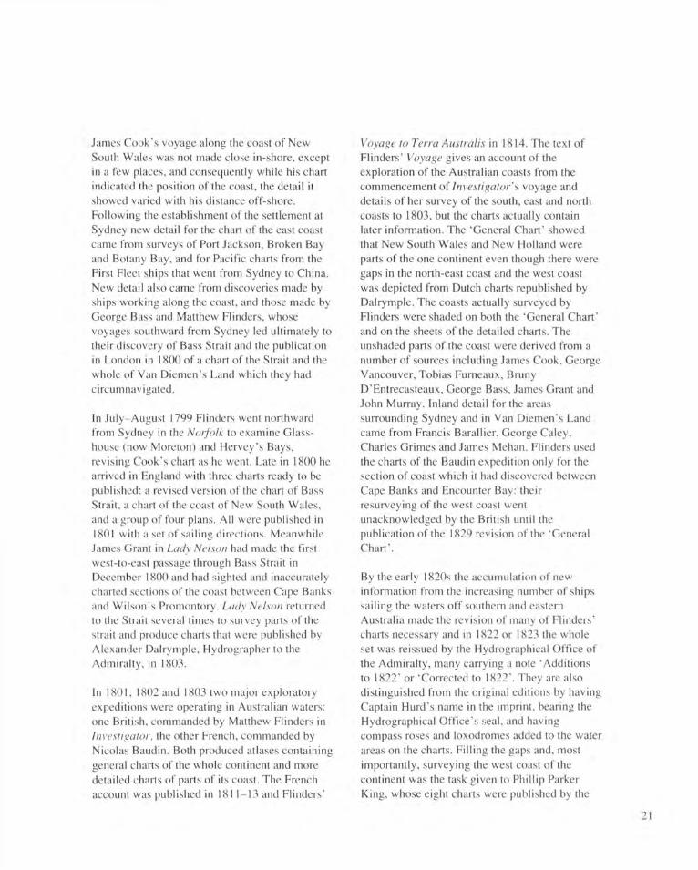
In 1801, 1802 and 1803 two major exploratory expeditions were operating in Australian waters: one British, commanded by Matthew Flinders in Investigator, the other French, commanded by Nicolas Baudin. Both produced atlases containing general charts of the whole continent and more detailed charts of parts of its coast. The French account was published in 1811-13 and Flinders'
Voyage to Terra Austral is in 1814. The text of Flinders' Voyage gives an account of the exploration of the Australian coasts from the commencement of Investigator's voyage and details of her survey of the south, east and north coasts to 1803, but the charts actually contain later information. The 'General Chart' showed that New South Wales and New Holland were parts of the one continent even though there were gaps in the north-east coast and the west coast was depicted from Dutch charts republished by Dalrymple. The coasts actually surveyed by Flinders were shaded on both the 'General Chart' and on the sheets of the detailed charts. The unshaded parts of the coast were derived from a number of sources including James Cook, George Vancouver, Tobias Furneaux, Bruny D'Entrecasteaux, George Bass, James Grant and John Murray. Inland detail for the areas surrounding Sydney and in Van Diemen's Land came from Francis Barallier, George Caley, Charles Grimes and James Mehan. Flinders used the charts of the Baudin expedition only for the section of coast which it had discovered between Cape Banks and Encounter Bay: their resurveying of the west coast went unacknowledged by the British until the publication of the 1829 revision of the 'General Chart'.
By the early 1820s the accumulation of new information from the increasing number of ships sailing the waters off southern and eastern Australia made the revision of many of Flinders' charts necessary and in 1822 or 1823 the whole set was reissued by the Hydrographical Office of the Admiralty, many carrying a note 'Additions to 1822' or 'Corrected to 1822'. They are also distinguished from the original editions by having Captain Hurd's name in the imprint, bearing the Hydrographical Office's seal, and having compass roses and loxodromes added to the water areas on the charts. Filling the gaps and, most importantly, surveying the west coast of the continent was the task given to Phillip Parker King, whose eight charts were published by the
21
Matlhew Flinders General Chart of Terra Australis (1X14)
Admiralty in 1824 and 1825. The publication of King's charts of the north-east coast made two of Flinders' charts, based on Cook's survey, obsolete and they were not reissued. The others, with King's charts, made a set that covered the whole continent. Individual charts were frequently revised and reprinted by the Hydrographical Office, which, in 1830, published the first volume of The Australia Directory.
The process of revision and correction of existing charts was not wholly satisfactory, and from time to time increasing traffic made new surveys of parts of the coast necessary. Between 1837 and 1843 HMS Beagle, Commander J.C. Wickham, was used to resurvey some of the more frequented parts of the south coast of the continent: the approaches to Perth, Bunbury, Albany and Adelaide; Bass Strait and its northern and southern shores; and many sections of the northern coasts. Wickham's surveys mark the virtual end of the exploratory phase of the charting of Australian coasts. Thereafter there were few areas, and those
small, that needed to be explored, and the emphasis moved to the resurveying of seaways and ports for the increasing numbers of larger and faster ships trading to, and between, a growing number of ports within Australia, New Zealand, and the islands of the South Pacific. This new emphasis is seen in the surveys made between 1853 and 1861 by HMS Herald, Captain H.M. Denham, of many parts of the Australian coast and some of the Pacific Islands, and the work of later hydrographic surveyors who divided their time between Australian and Pacific-island waters. Until 1919 almost all hydrographic surveys in Australian waters were conducted by Royal Navy ships operating for the Admiralty's Hydrographic Office. In 1921 the Royal Australian Naval Surveying Service was formed and has since assumed responsibility for conducting surveys and, since World War II, publishing nautical charts of Australian waters.
T.M. Perry University of Melbourne
22
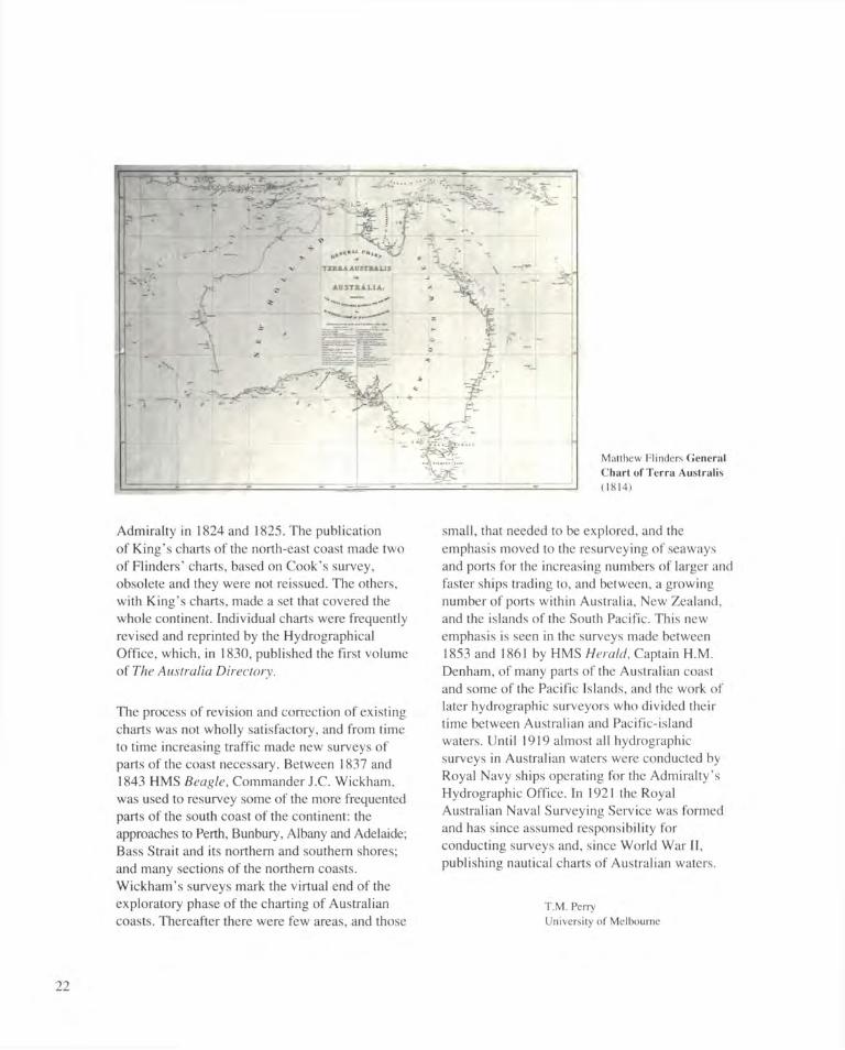
Gilles Robert de Vaugondy Carte reduite de l'Australasie (1756)
Cook, Banks and their companions had a considerable library on board the Endeavour, and a large collection of charts. Amongst them was this map, derived from the ideas of French theoretical geography. The Jordan River, the name 'Terre de St. Esprit' and the city of New Jerusalem hark back to the Portuguese visionary Pedro Fernandez de Ouiros, who visited the New Hebrides in 1605. It comes from a work of 1756 by the French writer Charles De Brosses, who urged the foundation of a French convict colony in 'Nouvelle Hollande'.
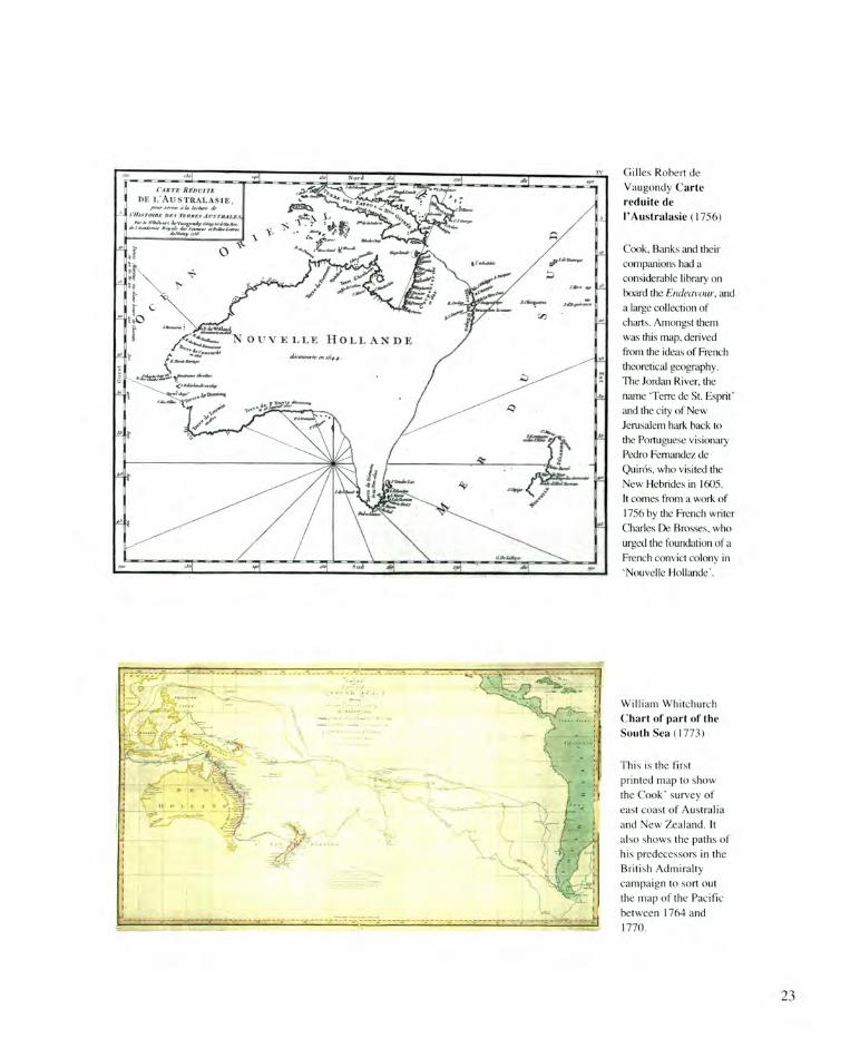
William Whitchurch Chart of part of the South Sea (1773)
This is the first printed map to show the Cook' survey of east coast of Australia and New Zealand. It also shows the paths of his predecessors in the British Admiralty campaign to sort out the map of the Pacific between 1764 and 1770.
23
BEACH MAPS
The Australian coastline contains approximately 7000 ocean beaches which extend well over half the coast. Since the turn of the century many of these beaches have become a focus for recreation, residential development and increasingly, tourism. There have been some associated problems, with numerous tragedies and rescues occurring as surf bathing spread in popularity in the first years of the century.
The response to this was the formation of the world's first surf life saving clubs at Manly and Bronte beaches in 1903, and the Australian Surf Life Saving Association in 1907. Today volunteer life savers patrol 256 beaches in every state and the Northern Territory, while professional life savers patrol an additional fifty. After ninety years of patrolling our most popular beaches the SLSA has built up a considerable knowledge of beach and surf conditions around the coast. However, local knowledge has usually been retained by the more experienced club members and this information has not always been available to others using the beaches.
At the same time our scientific understanding of beach conditions, the role of waves, rip currents and sand bars has increased considerably, very much due to field research undertaken by the Coastal Studies Unit, University of Sydney, at beaches around Australia over the past fifteen years.
In recognition of the need to combine these two sources of information for the benefit of the public, the Australian Beach Safety and Management Program commenced in 1987. Its aims are to compile accurate information on the location, nature, access, characteristics, facilities, usage and natural hazards of all Australian beaches. Included in its computer database are detailed maps of the patrolled beaches showing locations of bars, troughs, rip currents, rocks and other features under a typical range of wave and tide conditions.
To compile this database and, in particular, the individual beach maps, the following information
and acquisition techniques were used. Firstly, large scale topographic maps of the entire coast at scales between 1:25 000 to 1:100 000 were used to locate all major beaches. All existing aerial photographs were examined, including black and white and colour.They ranged in scale from 1:4000 to 1:40 000 and were used to accurately locate each beach, including the many not shown, or shown accurately enough, on the maps; and to record the surf and bar pattern on the day of the photograph. The coastline of each state was photographed at low altitude to record each beach and any beaches that had been missed on the maps and aerial photographs. This was then followed by ground inspection of all beaches accessible by vehicle. Some of the more inaccessible beaches were reached using inshore rescue boats or on foot. The purpose of site inspections was to obtain additional information on beach gradients, sediment character and other features not readily apparent or visible from the air. Finally, the life savers on all patrolled beaches were provided with a base map of their beach upon which they recorded daily wave and surf conditions and sketched the location of bars, troughs, rips, as well as the circumstances and location of any rescues.
Once all this information was available, the maps and aerial photographs were used to produce a base map showing the outline of the beach and the backing streets and or facilities. The daily beach maps were sorted by wave direction and height. Next, each set of maps for a particular direction and height were overlain to delineate the general character of the beach, particularly the location of bars, troughs, rips as well as any important local feature such as rocks or reefs. This information was then digitised onto the base map, with a separate map for each set of conditions, as well as a general map for typical conditions.
2 4
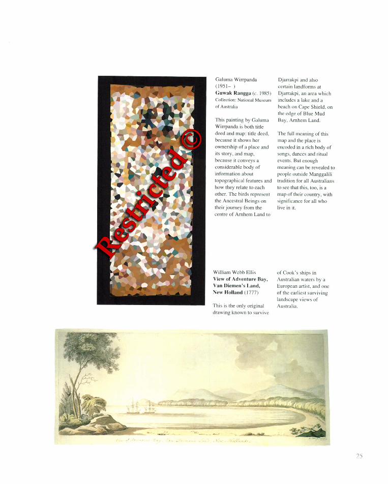
Galuma Wirrpanda (1951 - ) Guwak Rangga (c. 1985) Collection: National Museum
of Australia
This painting by Galuma
Wirrpanda is both title
deed and map: title deed. because it shows her ownership of a place and
it s story. and map. because it conveys a
considerable body of
information about topographical features and how they relate to each
other. The birds represent
the Ancestral Beings on their journey from the
centre of Arnhem Land to
Djarrakpi and also
cert ain landforms at Djarrakpi . an area which
includes a lake and a
beach on Cape Shield. on the edge of Blue Mud
Bay. Arnhem Land.
The full meaning of thi s
map 'U1d the place is encoded in a rich body of songs. dances and ritual
events. But enough meaning can be revealed to
people outside Manggalili trad ition for all Australians
to see that th is. too. is a map of their country. with
significance for all who li ve in it.
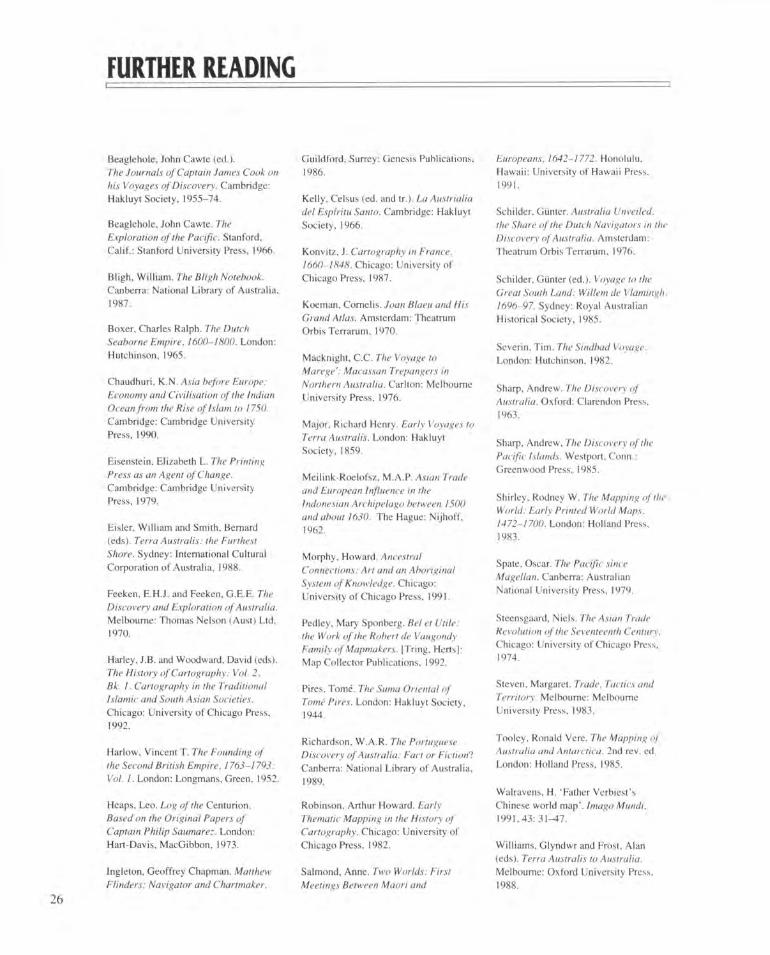
Willi am Webb Ellis
View of Adventure Bay, Van Diemen 's Land, New Holland ( 1777)
This is the onl y original
drawing known to survive
of Cook's ships in
Australian waters by a European arti st. and one of the earliest survi ving landscape views of
Australia.
FURTHER READING
Beaglehole, John Cawte (ed.). The Journals of Captain James Cook on his Voyages of Discovery. Cambridge: Hakluyt Society, 1955-74.
Beaglehole, John Cawte. The Exploration of the Pacific. Stanford, Calif.: Stanford University Press, 1966.
Bligh, William. The Bligh Notebook. Canberra: National Library of Australia. 1987.
Boxer, Charles Ralph. The Dutch Seaborne Empire. 1600-1800. London: Hutchinson, 1965.
Chaudhuri, K.N. Asia before Europe: Economy and Civilisation of the Indian Ocean from the Rise of Islam to 1750. Cambridge: Cambridge University Press, 1990.
Eisenstein, Elizabeth L. The Printing Press as an Agent of Change. Cambridge: Cambridge University Press, 1979.
Eisler, William and Smith. Bernard (eds). Terra Australis: the Furthest Shore. Sydney: International Cultural Corporation of Australia. 1988.
Feeken, E.H.J, and Feeken, G.E.E. The Discovery and Exploration of Australia. Melbourne: Thomas Nelson (Aust) Ltd, 1970.
Harley, J.B. and Woodward, David (eds). The History of Cartography: Vol. 2, Bk. I. Cartography in the Traditional Islamic and South Asian Societies. Chicago: University of Chicago Press, 1992.
Harlow, Vincent T. The Founding of the Second British Empire. 1763-1793: Vol. 1. London: Longmans. Green, 1952.
Heaps. Leo. Log of the Centurion. Based on the Original Papers of Captain Philip Saumarez. London: Hart-Davis, MacGibbon, 1973.
Ingleton, Geoffrey Chapman. Matthew Flinders: Navigator and Chartmaker.
Guildford, Surrey: Genesis Publications, 1986.
Kelly, Celsus (ed. and tr.). La Austrialia del Espiritu Santo. Cambridge: Hakluyt Society, 1966.
Konvitz, J. Cartography in France. 1660-1848. Chicago: University of Chicago Press, 1987.
Koeman, Cornells. Joan Blaeu and His Grand Atlas. Amsterdam: Theatrum Orbis Terrarum, 1970.
Macknight, C.C. The Voyage to Marege': Macassan Trepangers in Northern Australia. Carlton: Melbourne University Press, 1976.
Major. Richard Henry. Early Voyages to Terra Australis. London: Hakluyt Society, 1859.
Meilink-Roelofsz, M.A.P. Asian Trade and European Influence in the Indonesian Archipelago between 1500 and about 1630. The Hague: Nijhoff, 1962.
Morphy. Howard. Ancestral Connections: Art and an Aboriginal System of Knowledge. Chicago: University of Chicago Press, 1991.
Pedley. Mary Sponberg. Bel et Utile: the Work of the Robert de Vaugondy Family of Mapmakers. [Tring, Herts]: Map Collector Publications, 1992.
Pires, Tome. The Suma Oriental of Tome Pires. London: Hakluyt Society, 1944.
Richardson, W.A.R. The Portuguese Discovery of Australia: Fact or Fiction? Canberra: National Library of Australia, 1989.
Robinson, Arthur Howard. Early Thematic Mapping in the History of Cartography. Chicago: University of Chicago Press, 1982.
Salmond, Anne. Two Worlds: First Meetings Between Maori and
Europeans, 1642-1772. Honolulu, Hawaii: University of Hawaii Press, 1991.
Schilder. Giinter. Australia Unveiled: the Share of the Dutch Navigators in the Discovery of Australia. Amsterdam: Theatrum Orbis Terrarum. 1976.
Schilder, Gunter (ed.). Voyage to the Great South Land: Willem de Vlamingh, 1696-97. Sydney: Royal Australian Historical Society, 1985.
Severin, Tim. The Sindbad Voyage. London: Hutchinson, 1982.
Sharp, Andrew. The Discovery of Australia. Oxford: Clarendon Press, 1963.
Sharp, Andrew, The Discovery of the Pacific Islands. Westport, Conn.: Greenwood Press. 1985.
Shirley. Rodney W. The Mapping of the World: Early Printed World Maps, 1472-1700. London: Holland Press, 1983.
Spate, Oscar. The Pacific since Magellan. Canberra: Australian National University Press, 1979.
Steensgaard, Niels. The Asian Trade Revolution of the Seventeenth Century. Chicago: University of Chicago Press. 1974.
Steven, Margaret. Trade. Tactics and Territory. Melbourne: Melbourne University Press, 1983.
Tooley, Ronald Vere. The Mapping of Australia and Antarctica. 2nd rev. ed. London: Holland Press. 1985.
Walravens, H. 'Father Verbiest's Chinese world map'. Imago Mundi. 1991,43: 31-47.
Williams, Glyndwr and Frost, Alan (eds). Terra Australis to Australia. Melbourne: Oxford University Press. 1988.
2 6
CHECKLIST
1 Hartmann Schedel (1440-1514) Untitled Ptolemaic World Map Nuremberg, 1493 Woodcut From Schedel's Liber cronicarum (Nuremberg: Anton Koberger, 1493) 30.7 x 43.4 cm MAP NK 6074 Rex Nan Kivell Collection, National Library of Australia
2 Hartmann Schedel (1440-1514) Liber cronicarum Nuremberg: Anton Koberger, 1493 RBRS 5 NK 3977 Rex Nan Kivell Collection. National Library of Australia
3 Sebastian Minister (1489-1552) Ptolemaisch general tafel begreiffend die halbe Kugel der Weldt Basel: Heinrich Petri, 1567 Coloured woodcut 25 x 34.3 cm MAP NK 5781 Rex Nan Kivell Collection, National Library of Australia
4 Andrea Corsali Copia de la litera p. Andrea Corsali mandato alo Serenissima Prencipe Duca juliano de Medici Venice?, between 1516and 1523 Manuscript on vellum National Library of Australia MS 7860 On long-term loan to the National Library of Australia from the Bruce and Joy Reid Foundation
5 Martin Waldseemuller (1470-1521) Carta Marina (reproduction) Strassburg: Martin Waldseemuller, 1516
Original woodcut (133.5 x 248 cm)
6 Unknown cartographer after Claudius Ptolemy India Orientalis
Lvgdvni. 1535 Coloured woodcut 11.7 x 16.5 cm In Clauclii Plolemaei Alexandrini geographical' enarralionis. Lvgdvni: Melchioris et Gasparis Trechsel Fratrum, 1535 MAP RA 1 Petherick Collection, National Library of Australia
7 Girolamo Ruscelli Orbis Descriptio Venice: Appresso Vincenzo Valggrit, 1561 Copper engraving 18 x 26 cm MAP RM 149 Petherick Collection, National Library of Australia
8 Abraham Ortelius (1527-98) Typus Orbis Terrarum Antwerp: Abraham Ortelius, 1570 Coloured engraving 33.5 x 49.5 cm MAP NK 10001 Rex Nan Kivell Collection. National Library of Australia
9 Abraham Ortelius (1527-98) Indiae Orientalis insularumque adiacentium typus Antwerp: Abraham Ortelius, 1570 Coloured engraving 32.4 x 47.3 cm MAP NK5318 Rex Nan Kivell Collection, National Library of Australia
10 Benedictus Arias Montanus (1527-98) Sacrae Geographiae tabulam ex antiquissimorum cultop P'amiliis a Mose pecensitis Antwerp: Christopher Plantin. 1572 Coloured woodcut 31x51.5 cm MAP RM 2597, National Library of Australia Purchased 1986
1 1 Heinrich Bunting (1545-1606) Die eigentliche und warhafftige gestalt der Erden und des Meers. Cosmographia Universalis Magdeburg: P. Donat. 1581 Woodcut 26.5 x 36.2 cm MAP RM 2430, National Library of Australia Purchased 1985
12 Petrus Plancius (1552-1622) Orbis Terrarum Amsterdam: Petrus Plancius. 1594 39 x 57.5 cm Copper engraving MAP RM 144 Petherick Collection. National Library of Australia
13 Hessel Gerritsz (1581-1632) Caert van't Laudi van d'Eendracht Amsterdam: met Octroy vande H.M.H. de Staten Generael der vereenighde Nedcrlanden. 1627 Coloured copper engraving 29 x 61.7 cm MAP RM 749, National Library of Australia
14 Hessel Gerritsz (1581-1632) Discoveries around the West Coast of Australia Amsterdam: met Octroy Vande H.M. Heeren de Staten Generael der Vereenichde Neerlanden. 1631 Coloured copper engraving 51.4 x 34 cm MAP RM 750, National Library of Australia
15 Willem Janszoon Blaeu (1571-1638) India quae orientalis dicitur et insvlae adiacentes Amsterdam: Blaeu. 1635 Coloured copper engraving 39.5 x 48.5 cm MAP NK 10181 Rex Nan Kivell Collection. National Library of Australia
27
Collection: State Library of New South Wales
22 Joannes van Braam Kaart der Reyse van Abel Tasman Dordrecht: Joannes Van Braam. 1726 Engraving In Francois Valentijn's Oud en nieuw Oost-Indien, vol. 3 part 2 (Dordrecht: Joannes Van Braam, 1726) RBq MIS 234, National Library of Australia
23 Jacob Gerritsz Cuyp (1594-1651) Portrait of Abel Tasman, his wife and daughter Oil on canvas, r. 1637 106.7 x 132.1 T267 NK 3 Rex Nan Kivell Collection. National Library of Australia
24 Hendrick Doncker (1629-99) De zee-atlas ofte water-waereld Amsterdam: Hendrick Doncker, 1659 MAP RA 10, Petherick Collection. National Library of Australia
25 Gerard van Keulen (?-1726) 't Zuyd Landt Ontdekt door Willem de Vlaming 1701 Manuscript on compass-lined paper 56.8 x 97 cm MAP RM 751, National Library of Australia
2d Gerard van Keulen (7-1726) 't Zuyd Land Ontdekt door Willem de Vlamingh 1701 Manuscript on compass-lined paper 56.8 x 97 cm MAP RM 752, National Library of Australia
27 Ferdinand Verbiest (1623-88) World Map: Eastern Hemisphere Beijing, c. 1674
Manuscript and woodblock on silk rebacked with paper and relined onto silk 268 x 177 cm Presented to the National Library of Australia by Mr W. Hardy Wilson, 1949
28 Vincenzo Maria Coronelli (1650-1718) Asia Venice, 1696 Engraving 2 sheets each 58 x 43 cm MAPT 351/1-2 Tooley Collection, National Library of Australia
29 Vincenzo Maria Coronelli (1650-1718) Terrestial Globe Venice, 1688 108 cm diameter National Library of Australia Facsimile made by J.C. Eade, 1978
30 Hendrick de Leth (c. 1700-1759 or 1776) Carte nouvelle de la Mer du Sud Amsterdam: A. & H. de Leth, ? Coloured engraving 53.3x91.6 cm MAP T 857 Tooley Collection, National Library of Australia
31 Henri Abraham Chatelain (1684-1743) Carte tres curieuse de la mer du sud Amsterdam. 1719 Coloured engraving 77.5 x 138 cm MAP RM 73, National Library of Australia
32 Philippe Buache (1700-73) Carte des Terres Australes comprises entre le Tropique du Capricorne et le Pole Antarctique Paris: Chez Dezauche, 1739 Coloured engraving 25 cm diam. planisphere within border 23.5 x 30.8 cm
28
16 Henricus Hondius (1597-1651) Polus Antarcticus Amsterdam: H. Hondius, 1641 Coloured copper engraving 41.5 cm diameter MAP T 727 Tooley Collection. National Library of Australia
17 Jean Pierre Purry (1675-1736) Memoire sur le pais des Cafres, et la terre de Nuyts Amsterdam: Chez Pierre Humbert, 1718 SR 325.94 P9K5 Petherick Collection, National Library of Australia
18 Sir Robert Dudley (1574-1649) Arcano del mare Florence: Guiseppe Cocchini. 1661 MAP RA 248. National Library of Australia Purchased 1985
19 Joseph Moxon (1627-1700) Large Map of the World London: J. Moxon, c. 1670 Engraving 56.1 x 84.5 cm MAP RM 2285, National Library of Australia Purchased 1984
20 P. Du Val Carte Universelle du Commerce Paris: P. Du Val. 1677 Engraving 33.5 x 53.2 cm MAP RM 88 Petherick Collection. National Library of Australia
21 Unknown copyist after Abel Tasman (16037-59) Tasman map Coloured manuscript map on japan vellum The Netherlands? 1690s? 72 x 94 cm
MAP T 270 Tooley Collection. National Library of Australia
33 Philip Saumarez (1710-47) Journal on board the Centurion. Entry for 20 June 1743 Manuscript National Library of Australia MS 6740/4 Presented to the Library in 1981 by N.T. Finances Pty Ltd under the Taxation Incentives for the Arts Scheme
34 Philip Saumarez (1710-47) Abstract of a Journal of a Voyage to the South Seas 1744? Manuscript National Library of Australia MS 6740/5 Presented to the Library in 1981 by N.T. Finances Pty Ltd under the Taxation Incentives for the Arts Scheme
35 Lima coins England, 1740s
Collection: Museum of Victoria
36 Fdmond Halley (1656-1742) A New and Correct Chart of the World shewing the Variations of the Compass as they were found in the year MDCC London: Sold by R. Mount and T. Page on Great Tower Hill. 1702 Coloured engraving 52 x 147.5 cm MAP RM 2992, National Library of Australia Purchased 1991 37 William Hodges (1744-97) Portrait of Captain James Cook, R.N. (reproduction) 1775 or 1776 Original oil on canvas Collection: National Maritime Museum London
38 National Library of Australia MS 1 Purchased 1923
44 Great Britain. Admiralty Instructions to Lt. James Cook, 30 July 1768 In the Endeavour Letter Book. 1768-71 National Library of Australia MS 2 Purchased 1923
45 John Hawkesworth An Account of the Voyages undertaken ...for making Discoveries in the Southern Hemisphere Dublin: J. Potts. 1775 SR 910.41 H392, National Library of Australia
46 William Whitchurch Chart of part of the South Sea London: W. Strahan, 1773 52 x 88.5 cm MAP RM 561. National Library of Australia
47 William Webb Ellis (1747-85) View of Adventure Bay, Van Diemen's Land, New Holland 1777 pen and ink over pencil 19.5x46.5 cm National Library of Australia R 11282 Purchased 1993
48 William Webb Ellis (1747-85) An Authentic Narrative of a Voyage performed by Captain Cook and Captain Clerke, in His Majesty's Ships Resolution and Discovery London: Printed for G. Robinson. J. Sewell and J. Debrett, 1782 FERG 7190 Ferguson Collection, National Library of Australia
49 Letter, John Douglas to John Montagu, Earl of Sandwich, 20 November 1782 National Library of Australia MS 7218/22(ii)
29
Gilles Robert de Vaugondy (1688-1766) Carte reduite de I'Australasie Paris: Chez Durand, 1756 Engraving 21.7x27.2 cm MAPT 1002 Tooley Collection, National Library of Australia
39 Charles de Brasses (1709-77) Histoire des Navigations aux Terres Australes Paris: Chez Durand, 1756, volume I RB 910.8 BRO Petherick Collection. National Library of Australia
40 Emanuel Bowen ('?— 1767) A Complete Map of the Southern Continent London: J. Harris. 1744 Engraving 37.5 x 48.5 cm MAP NK 4185 Rex Nan Kivell Collection. National Library of Australia
41 Melchisedech Thevenot (16207-92) Hollandia Nova Paris: J. Langlois, 1663 Engraving Original 38.5 x 57.5 cm MAP RM 689, National Library of Australia
42 Samuel Dunn (7-1794) The Earths Eastern Hemisphere London: S. Dunn & W. Owen. 1757 Coloured engraving Diameter 53 cm MAPT 534 Tooley Collection, National Library of Australia
43 James Cook (1728-79) Remarkable Occurrences on board His Majesty's Bark Endeavour 1769-71
50 James Cook (1728-79) Chart of New Zealand London, 1772 Engraving 46.5 x 35.5 cm MAP T 322 Tooley Collection, National Library of Australia
51 Toogee Teterrenue Warripedo Facsimile of a Chart of New Zealand London: Cadell & Davies, 1798 Engraving 39 x 51 cm MAP NK 11077 Rex Nan Kivell Collection, National Library of Australia
52 Benjamin Baker (working 1766-1824) Chart of the Coast between Botany Bay and Broken Bay surveyed in 1788 and 89 by Captain John Hunter London: J. Stockdale. 1792 Engraving 40 x 72.3 cm MAP T 742 Tooley Collection, National Library of Australia
53 Daniel Djurberg (1744-1834) Karta over Polynesien eller femte delen af jordklotet Stockholm: Saljes hos Bokhandler en Holmberg, 1790 Engraving 44.5 x 69.8 cm MAP RM 2284, National Library of Australia Purchased 1984
54 George Adams (1704-73) Terrestial Globe, captioned: Globum hunc Terrestrem London: G. Adams, c. 1772 Coloured engraving, brass and mahogany 46 cm diameter, overall height 81 cm Private collection
55 Letter, Daincy Barrington to John Montagu, Earl of Sandwich, 24 April 1781 National Library of Australia MS 7218/9
56 Ivan Fedorovich Kruzenshtern (1770-1846) Puteshestvie vokrug svieta v 1803, 4, 5 i 1806 godakh St Petersburg: Morskaia Tipografia. 1809-13 Atlas volume published 1827 MAP RA 258 Presented to the National Library of Australia by the Bruce and Joy Reid Foundation 1988
57 William Bligh (1754-1817) 'Rough account—Lieutenant Wm Bligh's Voyage in the Bounty's Launch from the Ship to Tofua and from thence to Timor' Manuscript 1789 Purchased 1976
National Library of Australia MS 539.3
58
William Bligh (1754-1817) A Chart of Bligh's Straits in the Clarence Archipelago Discovered and Explored by Captain William Bligh of the Royal Navy ... September 1792 Manuscript map 1790s? 39 x 51 cm National Library of Australia MS 6423 Purchased 1980 59 Robert Laurie (1755-1836) A New Chart of the Eastern Coast of New Holland from South Cape to Cape York London: Laurie & Whittle, 1799 Engraving 100 x 66.7 cm MAP T 855 Tooley Collection. National Library of Australia
60 Matthew Flinders (1774-1814) Observations on the coasts of Van Diemen's Land London: Printed by John Nichols. 1801 National Library of Australia F 329
61 I. Andrews A General Chart of the Passage from England to Botany Bay in New Holland London: J. Stockdale. 1787 Coloured engraving 2.3.5 x 38 cm In The History of New Holland (London: J. Stockdale, 1787) FRM NK 393 Rex Nan Kivell Collection, National Library of Australia
62 Matthew Flinders (1774-1814) General Chart of Terra Australis or Australia showing the parts explored between 1798 and 1803 London: G. & W. Nicol, 1814 Engraving 6.3.2 x 92 cm MAP T 570 Tooley Collection, National Library of Australia
63 Matthew Flinders (1774-1814) A Voyage to Terra Australis; undertaken for the purpose of completing the discovery of that vast country London: G. & W. Nicol. 1814 National Library of Australia Robinson 387
64 William Westall (1781-1850) Wreck of the Porpoise, Flinders Expedition (reproduction) 1803 Original watercolour. 31.2 x 46 cm National Library of Australia R 7062
30
65 Louis de Freycinet (1779-1842) Carte generale de la Terre Napoleon Paris. 1815 Engraving Plate 10 of his Voyage de decouverles aux Terres Australes (Paris: de l'Imprimerie Royale. 1812) NK 1434 Rex Nan Kivell Collection. National Library of Australia
66 William Westall (1781-1850) King George's Sound, View from the North-West 1801 Pencil and wash on paper 16 x 26.6 cm National Library of Australia R 4263 Acquired 1969
67 William Westall (1781-1850) Views on the South Coast of Australia 1801-02 Watercolour 31.1 x 44.5 cm National Library of Australia R 4386 Acquired 1969
68 William Westall (1781-1850) The English Company's Islands, Probasso, a Malay Chief 1803 Pencil on paper 27.7 x 17.6 cm National Library of Australia R 4366 Acquired 1969
69 Samuel Middiman (1750-1831) after William Wcstall (1781-1850) View of Malay Road from Pobasso's Island London: G. & W. Nicol, 1814 Engraving 15.5 x 22.5 cm NK 1730 Rex Nan Kivell Collection. National Library of Australia
7(1 Jose de Espinosa y Tello (1763-1815) Carta general para les Navegaciones a la India Oriental London: J. Espinosa, 1814 Engraving with manuscript addition 125 x 157.5 cm MAP RM 2076, National Library of Australia Purchased 1983
71 Felipe Bauza (working 1789-1841) Piano Del Puerto Jakson Sydney?, 1793 Facsimile of a manuscript in the Museo Naval. Madrid
72 Attributed to Nicholas Vallard (working 1547) First Map of Australia Worcestershire: Middle Hall Press. 1856 Chromolithograph 37.2 x 47.2 cm MAP NK 9679 Rex Nan Kivell Collection. National Library of Australia
73 Alexandre A. Vuillemin (1812-?) Nouvelle Carte Illustree de I'Oceanie Paris: chez Fatout. 1859 Engraving 57.5 x 66 cm MAPT 1307 Tooley Collection. National Library of Australia
74 John L. Roe A Survey of St. Asaph Bay, and Port Coekburn, with Part of Apsley Strait, on the North Coast of Australia Sydney: Hydrographic Branch, Royal Australian Navy. 1943 Coloured lithograph 60 x 46 cm Admiralty Chart 1046. National Library of Australia
75 R.B.A. Hunt Port Darwin fair chart Manuscript 120 x 128.5 cm V8/50 Collection: Hydrographic Branch. Royal Australian Navy
76 R.B.A. Hunt Port Darwin Japan: Hydrographic Division. 1942 Lithograph 55.2 x 64 cm V3/608 Collection: Hydrographic Branch. Royal Australian Navy
77/1 Australian Beach Safety and Management Program Bronte Beach, New South Wales 1993 Courtesy of Coastal Studies Unit. University of Sydney
77/2 Australian Beach Safety and Management Program Caves Beach, Australian Capital Territory 1993 Courtesy of Coastal Studies Unit, University of Sydney
77/3 Australian Beach Safety and Management Program Scarboro Beach, Western Australia 1993 Courtesy of Coastal Studies Unit, University of Sydney
78 Hydrographic Branch. Royal Australian Navy Sydney Harbour 1993 Electronic Chart Display Information System Courtesy of the Hydrographic Branch. Royal Australian Navy
31
79 William Westall (1781-1850) Blue Mud Bay, Body of a Native Shot on Morgan's Island 1802 Pencil on paper 15.2 x 35 cm National Library of Australia R 4357 Acquired 1969
80 Matthew Flinders (1774-1814) North West side of the Gulf of Carpentaria London: G. & W. Nicol, 1814 Engraving 61.8 x 43 cm MAP T 584 Tooley Collection. National Library of Australia
81 Galuma Wirrpanda (1951- ) Manggalili clan Guwak Kangga c. 1985 Ochres on bark 133 x 61 cm 1985.45.15 Collection: National Museum of Australia
William Westall Blue Mud Bay, Body of a Native Shot on Morgan's Island (1802)
In 1802, at Blue Mud Bay on the west coast of the Gulf of Carpentaria, the crew of Flinders' Investigator shot and killed one of the local people, after the spearing of the master's mate. He was possibly a member of the Manggalili clan. He certainly knew the coast and its changing patterns well: he may even have travelled abroad with the trepang
gatherers from Macassar, as other Manggalili people had done. The next day his body was found. William Westall quickly sketched him before he was dissected and taken on board the Investigator. Where his bones now lie is unknown: perhaps they were lost with the Porpoise, perhaps they were shipped back to Britain, where so many Aboriginal remains were sent for the most dubious of scientific reasons. The agony of death is still apparent on his face. The chart Flinders made
of his home seas can say nothing of the cost of the work, nothing of the knowledge of Australia lost in the violence of our history. That is. perhaps, not what maps are about. But this exhibition is about the faces behind the maps, about the cost to us all of the history they represent. Perhaps in out time we can find ways to accept the many different types of knowledge that add up to a full understanding of Australia and its place in the world.
32