Embed Size (px)
Citation preview
ACTA GGM DEBRECINA Geology, Geomorphology, Physical Geography Series DEBRECEN Vol. 3, 145–153 2008
145
Changes in the state of Cumanian mounds lying in the vicinity of Karcag from the end of the 18th century till today
Karcag határában fekv kunhalmok állapotváltozása a 18. század végét l napjainkig
Judit Bukovszki ! Csaba Tóth
Department of Physical Geography and Geoinformatics, University of Debrecen, H-4010, Debrecen Egyetem tér 1. P.O.Box: 9
Abstract Due to the frequently contradictory data of different Cumanian mound surveying, in the vicinity of Karcag surveying was repeated in 2007–2008. Plotting the geographical distribution of the mounds on the digital elevation model and on the soil map of the area it was revealed that most of them are located in the near-water marginal zone of flood-free ridges lying at the edge of formerly extensive swamps. These areas are covered by meadow solonetz soil today. It was determined that the number of mounds was reduced by 40% due to carelessness and only in the last three decades 25% of the compared mounds suffered from deterioration (carrying away, damage, elimination of loess grasslands). Majority of the mounds in the vicinity of the town have an intact main body with ploughed surface thus presenting no or moderate landscape value. Regarding the 53 mounds only four is considered as highly valuable from nature conservation point of view. Összefoglalás A rendelkezésünkre álló kunhalom-kataszterezések sokszor ellentmondó adatai miatt Karcag határában 2007–2008 folyamán megismételtük a kunhalmok felmérését. A terület digitális domborzatmodelljén és talajtérképén ábrázolva a halmok földrajzi helyzetét, kiderült, hogy túlnyomó részük az egykor kiterjedt mocsarak peremén húzódó ármentes hátak vízközeli, peremi sávjában épült, amely jelenleg réti szolonyec talajokkal jellemezhet terület. Megállapítottuk, hogy a kunhalmok száma 40%-kal csökkent az emberi gondatlanság miatt, és csak az utóbbi három évtized folyamán, az összevetett halmok 25%-a szenvedett el állapotromlást (elhordás, roncsolás, löszgyepek elt!nése). Zömében ép halomtest!, de szántott, tájképileg nem, vagy csak közepesen értékes kunhalmok fordulnak el a város határában. A vizsgált 53 kunhalomból természetvédelmi szempontból csupán négyet találtunk kiemelten értékesnek. Key words Cumanian mounds, anthropogenic geomorphology, digital elevation model, nature conservation, survey of state Tárgyszavak kunhalmok, antropogén geomorfológia, digitális domborzatmodell, természetvédelem, állapotfelmérés
Introduction
Almost one century has passed since the first publication of a real geographical study of Cumanian mounds in the Földrajzi Közlemények by Béla Kozma that shed new light on the problem compared to the earlier archaeological publications. Based on the surveyed 1200 and the plotted 800 mounds he referred to the Great Hungarian Plain as one of the richest area in archaeological findings on the Earth. He revealed that most of the mounds are concentrated in an area bordered by Püspökladány – Balmazújváros – Tiszafüred Fegyvernek mainly in curvilinear bends on the flood free parts of active and abandoned beds (KOZMA 1910).
The present paper gives an outline on the law of the location and on the changes in number and state of mounds due to anthropogenic effects in history on the example of a settlement, Karcag the surroundings of which have the largest mound density in the country.
Origin of the term Cumanian mound
The term Cumanian mound in the Hungarian language
is originated from the notes of Willelmus Rubruk and Philippe de Toucy who recorded the large number of burial mounds and the burial rituals of the Kun people (GOMBOS 1937, GÁRDONYI 1893, 1914; LONGNON 1957). Using these sources it is possible that early Hungarian researcher István Horváth was the first to apply the term in literature (HORVÁTH 1825). According to the definition of the Karcag-born ethnographer, István Gy rffy: “A mound is an elevation that is known in the literature as Cumanian mound. These are located mainly in flood free, relatively
high (5–10 metres) elevations occupying smaller areas, and appearing as flat, cone or semi-spherical elevations. These are in almost every cases ancient burial mounds. At the same time they were accepted as border mounds by certain settlements” (GYÖRFFY 1921).
To name prehistoric mounds as Cumanian mounds is rejected by several authors as in many cases mounds were used by several peoples through thousands of years (for living, burial, etc.) and in the case of several thousand unexplored mounds it is impossible to determine which people constructed them (JERNEY 1851, HAMPEL 1889, KOZMA 1910). Uncertainties in the name are reflected well in the title of the publication of István Jakabffy: Are Cumanian mounds Cumanian? In his opinion the term Cumanian mound is a literature term that although shifted into the common language but it is not known generally among the people of the Great Hungarian Plain (JAKABFFY
1957). Conservation of the term might be good in respect of the fact that it reflects the anthropic character of the origin of the mounds by referring to the burial habits of the Cuman people separating them from the hill-like forms of natural origin (ridge, sand dune) (KOZMA 1910, ZOLTAI
1938, TÓTH 1999, TÓTH 2002).
Nature conservation relations of Cumanian mounds
Cumanian mounds are important geomorphological, landscape, cultural historical, flora and fauna value retaining objects of the Great Hungarian Plain. Breaking the dullness of the landscape they represent important scenic, orientation and benchmark places. In their surroundings significant soil degradation (secondary sodification, structure deterioration, etc.) is experienced due to the water
ACTA GGM DEBRECINA Geology, Geomorphology, Physical Geography Series Vol. 3 2008
146
regulation works of the 19th century and the intense agriculture. This degradation affected the surface of the mounds in only a limited extent. Thus good quality chernozem soil remained on the mounds holding significant soil value while formerly characteristic and today very rare loess grassland vegetation on the top of the mounds retain important biological value. Grasslands of the mounds elevated like islands from the monoculture vegetation of the surrounding arable lands represent a dryer and warmer micro-climate giving shelter and excellent habitat for numerous vertebrate and invertebrate animal species. Therefore Act LIII of the year 1996 on the protection of Nature designates every Cumanian mounds in Hungary as “ex lege” protected sites.
Research history of the mounds around Karcag
Cumanian mounds around Karcag were first
mentioned by Jen Cholnoky who suggested the pattern of the ancient Tisza beds studying the curvilinear distribution of the mounds (CHOLNOKY 1907). István Gy rffy drew the first maps of the ancient sites and mounds (GYÖRFFY
1921) located in the vicinity of the town. First survey of the mounds based on field experience
was performed by ISTVÁN ÖRÖKÖS in 1977 who as retired from agriculture knew well the surroundings of the settlement. Kurgan cadastre of the Trans-Tisza part of the Great Hungarian Plain was published by DÉNES VIRÁGH in 1979. This work involved no field study it summarised the number, diameter and relative height of the kurgans by settlements on the basis exclusively of archive and map-store documents. This publication indicates that most kurgans could have been in the surroundings of Hortobágy in the Trans-Tisza region with the number of 320 while in the vicinity of Karcag there could have been 134 mounds ensuring second place for the town in the Trans-Tisza region.
In 1980–1981 carrying out the cadastre of the Cumanian mounds in Szolnok county, Albert Tóth identified 31 Cumanian mounds in the field in the vicinity of Karcag. Main goal of the survey was to help the protection of the rapidly deteriorating mounds by presenting their state at that time. This survey gave a much detailed image on the mounds, their accessibility, geomorphological conditions, grade of disturbance, type of cultivation, landscape and botanical values. Besides giving archaeological and cultural historical information as well the survey classified mounds into 7 groups (TÓTH 1988, 1989, 1990).
The act of 1996 on the protection of Nature prescribed the preparation of a national Cumanian mound cadastre. Field survey of the mounds around Karcag was performed in 2000 and 32 mounds were involved in the national cadastre (TÓTH 2004). This detailed survey was aimed – among others – to record accurately the geographical position (co-ordinates in the United National Co-ordinate System) of the mounds thus identify the owners of the mounds. This was essential in the protection of the mounds. In 2005 the heritage protection impact assessment of the town was completed that lists all of the sited important from archaeological point of view and includes 51 mounds.
Research methods
Based on earlier publications and available maps (primarily 1:25000 and 1:10000 topographic maps of the 1st and 2nd military surveys) mounds around the town were identified in the field. This was necessary due to the contradictory character of data published earlier and to the deterioration of the state of the mounds in recent decades. In the survey the cadastre sheets used in the national survey and GPS instruments were applied. Data analysis was performed with the help of the software Microsoft Excel while for creating maps from the data the software ArcView 3.2 was applied.
Results
Studying the geomorphological map of the lowland
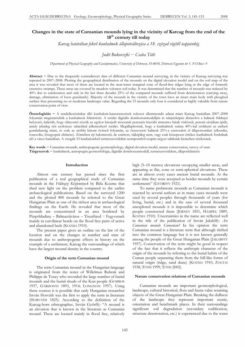
loess plain landscape type of the Nagykunság it can be stated that the geographical distribution of the Cumanian mounds is characterised by a curvilinear appearance instead of a scattered pattern (Figure 1). Cumanian mounds are located in almost every case on the flood free but near water forms of the lowland landscape that otherwise has very small heights differences. These forms are mainly the ridges of active or abandoned river beds, swamp edges and flood free islands. Simultaneously, in the northern part of the Nagykunság several hundred Cumanian mounds were formed by heightening of semi bond wind-blown sand forms (e.g. large ripple marks). This indicates that nomad cultures building mounds were completely adapted to the variable micro-relief of the Great Plain landscape.
Figure 1 Geomorphological map of the northern part of the
Nagykunság (TÓTH 2007)
1. ábra A Nagykunság északi részének geomorfológiai térképvázlata (TÓTH 2007)
Studying the digital elevation model of the
surroundings of Karcag it is clear that elevation of the area increases from the south towards the north, northwest (Figure 3). Southern edge of the town was part of an
Bukovszki, J. & Tóth, Cs.: Changes in the state of Cumanian mounds… ANTHROPIC GEOMORPHOLOGY
147
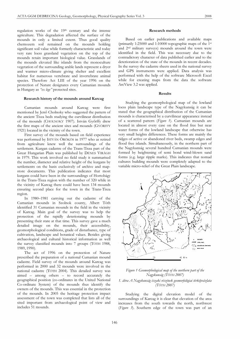
Figure 2 Map of Cumanian mounds and destructed villages in the vicinity of Karcag (GYÖRFFY 1921) (grey: flood free area)
2. ábra A karcagi határban lév kunhalmok és elpusztult falvak térképe (GYÖRFFY 1921) (szürke: ármentes terület)
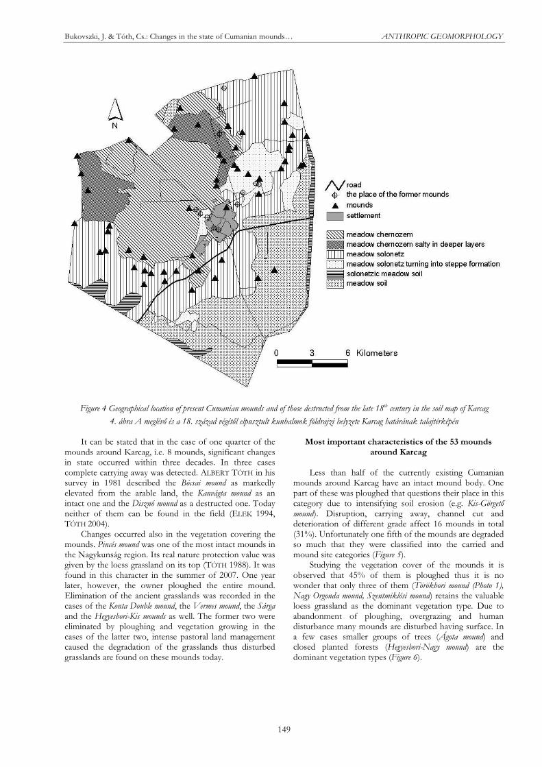
enormous marshland the Nagy-Sárrét supplied with water by the Hortobágy-Berettyó-Körös-Tisza system before river regulation works. Today this area is characterised mostly by meadow soils with elevation of 83–86 metres above sea level where Cumanian mound could not have been built until the water regulation works due to continuous water cover. Exceptions are the Apavára mound and the Kenderáztató mound (Figures 2 and 3) that were built on the islands of the swamp. Margins of this enormous swamp are well traceable in the digital elevation model (Figure 3). Apart from the pattern of the contour lines this belt with an elevation of 87–90m, characterised by meadow solonetz soil is indicated by the position of the core of Karcag and the 50 Cumanian mounds built here (Figures 3 and 4). From this NE-SW running floodplain edge belt the area elevates gently towards the present floodplain of the Tisza, towards N-NW. This area dominated by meadow chernozem and
deep salty meadow chernozem soils has much less Cumanian mounds, there are only a few along larger abandoned river beds (e.g. Üll flat) (Figures 3 and 4).
Comparing the number of Cumanian mounds in the vicinity of Karcag in the literature to data of our survey some contradictions can be found. Number of mounds published by VIRÁGH (1979) is one order more than that of earlier and later surveys (Table 1). This was the only survey based entirely on data-store research without field work suggesting that there could have been much more mounds in the Great Hungarian Plain in the 17th and 18th centuries than in the 20th century. On the other hand mistakes are more probable than in those including field work. Among mound like features only the artificial ones can be regarded as Cumanian mounds, natural ones (hummock, ridge, sand dune) can not. Type of forms cannot be cleared undoubtedly without field work.

ACTA GGM DEBRECINA Geology, Geomorphology, Physical Geography Series Vol. 3 2008
148
Figure 3 Digital elevation model of the surroundings of Karcag with the Cumanian mounds
3. ábra Karcag határának domborzatmodellje a kunhalmokkal
Table 1 Summary of data on the numbers of mounds around Karcag
1. táblázat A karcagi kunhalmok számbeli adatainak összefoglaló táblázata
Survey year
Surveyer name
Aim of survey Number of mounds
1921 ISTVÁN
GYÖRFFY
Construction of the map of Cumanian mounds and destructed villages around Karcag
48
1977 ISTVÁN ÖKRÖS
Parochial manuscript record of destructing mounds
41
1979 DÉNES VIRÁGH
Preparation of the kurgan cadastre of the Trans Tisza
134
1981 ALBERT TÓTH Preparation of the kurgan cadastre of Szolnok county
31
2000 CSABA TÓTH Preparation of the national kurgan cadastre
33
2005 MARIETTA
CSÁNYI
Preparation of an Heritage protection impact assessment
51
2008 JUDIT
BUKOVSZKI Diploma thesis, publication – review of earlier data
53
The rest of the data on the number of mounds was
obtained by field works having different technical conditions. Data of authors having local knowledge and
working only in the surroundings of the town are similar. From the county and the national cadastre surveying some mounds are missing. This can be partly explained by the short time available for the work, encryption of the detailed military maps (until the 1980s) and taking the valuable mounds forefront considering the aspect of nature protection that can be saved from destruction. From the recorded 53 Cumanian mounds only 41 can be regarded as real mounds markedly elevated from its surroundings reaching a relative height of 1.52 metres. The rest belong to the carried mound and mound site categories that cannot be regarded as real mounds. However, these mounds deteriorated recently are recorded in our database. If the 134 Cumanian mounds around Karcag published by Virágh are accepted then their number was reduced by almost 40%!
Besides reduction in number the changes in the state of the mounds was also recorded. During this the characteristics of only the 31 mounds surveyed in 1981 were compared to their present state as there were no details available from times before the survey in the 1980s.
Bukovszki, J. & Tóth, Cs.: Changes in the state of Cumanian mounds… ANTHROPIC GEOMORPHOLOGY
149
Figure 4 Geographical location of present Cumanian mounds and of those destructed from the late 18th century in the soil map of Karcag
4. ábra A meglév és a 18. század végét l elpusztult kunhalmok földrajzi helyzete Karcag határának talajtérképén
It can be stated that in the case of one quarter of the mounds around Karcag, i.e. 8 mounds, significant changes in state occurred within three decades. In three cases complete carrying away was detected. ALBERT TÓTH in his survey in 1981 described the Bócsai mound as markedly elevated from the arable land, the Kanvágta mound as an intact one and the Disznó mound as a destructed one. Today neither of them can be found in the field (ELEK 1994, TÓTH 2004).
Changes occurred also in the vegetation covering the mounds. Pincés mound was one of the most intact mounds in the Nagykunság region. Its real nature protection value was given by the loess grassland on its top (TÓTH 1988). It was found in this character in the summer of 2007. One year later, however, the owner ploughed the entire mound. Elimination of the ancient grasslands was recorded in the cases of the Konta Double mound, the Vermes mound, the Sárga and the Hegyesbori-Kis mounds as well. The former two were eliminated by ploughing and vegetation growing in the cases of the latter two, intense pastoral land management caused the degradation of the grasslands thus disturbed grasslands are found on these mounds today.
Most important characteristics of the 53 mounds around Karcag
Less than half of the currently existing Cumanian
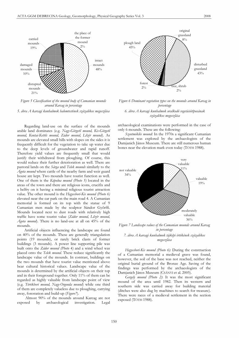
mounds around Karcag have an intact mound body. One part of these was ploughed that questions their place in this category due to intensifying soil erosion (e.g. Kis-Görget mound). Disruption, carrying away, channel cut and deterioration of different grade affect 16 mounds in total (31%). Unfortunately one fifth of the mounds are degraded so much that they were classified into the carried and mound site categories (Figure 5).
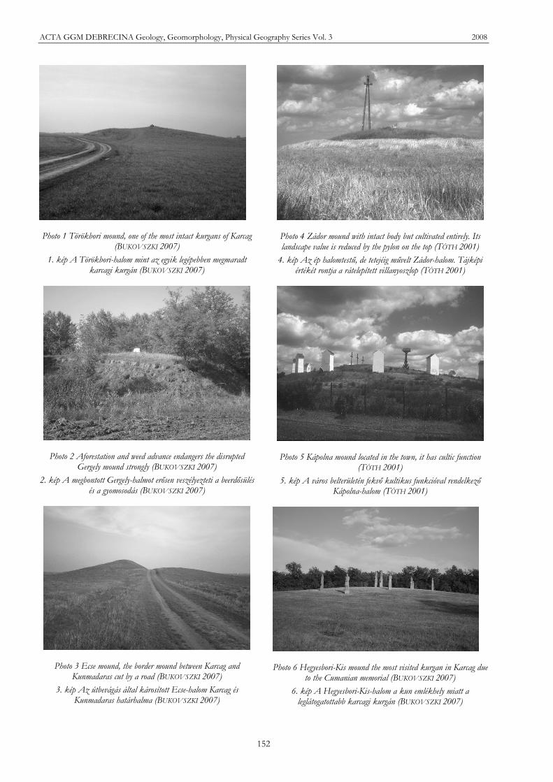
Studying the vegetation cover of the mounds it is observed that 45% of them is ploughed thus it is no wonder that only three of them (Törökbori mound (Photo 1), Nagy Orgonda mound, Szentmiklósi mound) retains the valuable loess grassland as the dominant vegetation type. Due to abandonment of ploughing, overgrazing and human disturbance many mounds are disturbed having surface. In a few cases smaller groups of trees (Ágota mound) and closed planted forests (Hegyesbori-Nagy mound) are the dominant vegetation types (Figure 6).
ACTA GGM DEBRECINA Geology, Geomorphology, Physical Geography Series Vol. 3 2008
150
intact mounds
48%
the place of the former
mound2%
carried mounds
19%
damaged mounds
10%
disrupted mounds
21%
plough land45%
original grassland
8%
disturbed grassland
43%
forest2% tree, shrub
2%
Figure 5 Classification of the mound body of Cumanian mounds around Karcag in percentage
5. ábra A karcagi kunhalmok halomtestének százalékos megoszlása
Figure 6 Dominant vegetation types on the mounds around Karcag in percentage
6. ábra A karcagi kunhalmok uralkodó vegetációtípusának százalékos megoszlása
Regarding land-use on the surface of the mounds arable land dominates (e.g. Nagy-Görget mound, Kis-Görget mound, Kontai-Kett s mound, Zádor mound, L zér mound). As mounds are elevated small hills with slopes on the sides it is frequently difficult for the vegetation to take up water due to the deep levels of groundwater and rapid runoff. Therefore yield values are frequently small that would justify their withdrawal from ploughing. Of course, this would reduce their further deterioration as well. There are pastoral lands on the Sárga and Telek mounds similarly to the Ágota mound where cattle of the nearby farm and weir guard house are kept. Two mounds have tourist function as well. One of them is the Kápolna mound (Photo 5) located in the areas of the town and there are religious icons, crucifix and a belfry on it having a minimal religious tourist attraction value. The other mound is the Hegyesbori-Kis mound (Photo 6) elevated near the car park on the main road 4. A Cumanian memorial is formed on its top with the statue of 9 Cumanian men made by the sculptor Sándor Gy rffi. Mounds located next to dust roads with relatively high traffic have some tourist value (Zádor mound, L zér mound, Ágota mound). There is no land-use at all on 45% of the mounds.
Artificial objects influencing the landscape are found on 40% of the mounds. These are generally triangulation points (19 mounds), or rarely brick clasts of former buildings (3 mounds). A power line supporting pile was built onto the Zádor mound (Photo 4) and a wind wheel was placed onto the Telek mound. These reduce significantly the landscape value of the mounds. In contrast, buildings on the two mounds that have tourist value mentioned above bear cultural historical values. Landscape value of the mounds is determined by the artificial objects on their top and in their foreground together. Only 11% of them can be regarded as highly valuable from landscape point of view (e.g. Törökbori mound, Nagy-Orgonda mound) while one third of them are completely valueless due to ploughing, carrying away, forestation and build-up (Figure7).
Almost 90% of the mounds around Karcag are not exposed by archaeological investigation. Legal
archaeological examinations were performed in the case of only 6 mounds. These are the following:
Szentmiklós mound: In the 1970s a significant Cumanian settlement was explored by the archaeologists of the Damjanich János Museum. There are still numerous human bones near the elevation mark even today (TÓTH 1988).
not valuable34%
moderately valuable
36%
very valuable
11%
valuable19%
Figure 7 Landscape values of the Cumanian mounds around Karcag
in percentage
7. ábra A karcagi kunhalmok tájképi értékének százalékos megoszlása
Hegyesbori-Kis mound (Photo 6): During the construction
of a Cumanian memorial a medieval grave was found, however, the soil of the base was not reached, neither the original burial ground of the Bronze Age. Saving of the findings was performed by the archaeologists of the Damjanich János Museum (CSÁNYI et al. 2005).
Gergely mound (Photo 2): It was the most significant mound of the area until 1982. Then its western and southern side was carried away for building material (ditches were also dug by machines to search for treasure). There were races of a medieval settlement in the section exposed (TÓTH 1988).
Bukovszki, J. & Tóth, Cs.: Changes in the state of Cumanian mounds… ANTHROPIC GEOMORPHOLOGY
151
Asszonyszállás mound: Probably a burial ground from the Copper Age. There was a medieval village on and around it. László Selmeczi performed exploration in the area (CSÁNYI et al. 2005).
Ágota mound: Medieval findings were found in it (TÓTH
1988). Bócsa mound: István Gy rffy and László Bartuz
explored it in 1924. Medieval church and a surrounding cemetery were found (TÓTH 1988).
Nagy Orgonda mound is worth mentioning as well on the top and on the sides of which several medieval bones and tile and brick fragments were found.
Apart from all these the rest of the cultural values (legends, historic events) recorded in written sources is worth mentioning that are associated with the following mounds:
Ágota mound: According to the traditions a chapel of Saint Ágota was on it in the Middle Ages that was deconstructed at the time of reformation, its bricks were built into the walls of the Ágota inn operated until the 1950s. According to the legend there was a secret tunnel serving the escape of wanted rascals (FAZEKAS 1997).
Asszonyszállás mound: Its name indicates a medieval village. According to the legend Ágota who was famous for her beauty lived here with her mother. The Cumanian hero Zádor born in Keve (Túrkeve) fell in love with her. The exciting tale is told by Péter Ujj a notary from Karcag in his poem legend in which in the end the pair is married (UJJ
1828). Zádor mound (Photo 4): see Asszonyszállás mound. Hegyesbori-Nagy mound: According to the unwritten
tradition of Karcag, legion led by Perczel of the Hungarian army withdrew and camped at this mound in January 1849 (TÓTH 1988).
L zér mound: According to a tale the dead body of a Turkish emissary who was killed by Cumanian shepherds for his nice horse was found west of this mound (GYÖRFFY 1984). Older unwritten tradition associates this tale with the Bengecsek mound.
Finally we examined the extent to which human activity around the mounds endangers the long-term sustainability of the mound bodies, the present botanical and landscape values. This study was performed only in the case of 42 mounds as carried mounds were excluded. Only three mounds have no endangering factors: Hegyesbori-Kis mound (maintained because of the memorial), Ecse mound (Photo 3) (located in a protected area – Hortobágy National Park), Kápolna mound (maintained and fenced cultic place). Around 70% of the mounds were classified as slightly endangered. Generally ploughing, weed advance and aforestation are potential sources of danger. Unfortunately
20% of the mounds are regarded to be strongly endangered. Best example for this category is the Tetves mound cut by two channels, however, all of the mounds smaller than 2 metres and cultivated intensively due to the ploughing of the mound bodies.
Summary
Our cadastre survey carried out in the vicinity of one
of the richest Hungarian settlements regarding Cumanian mounds was the seventh in time. Performing the work was felt necessary because primarily to filter inaccuracies in former data and to trace changes in the state of the mounds. Plotting the co-ordinates of the mounds on a map reveals that the constructors were adapted well to the seemingly dull but very mosaic landscape of the Great Hungarian Plain. Flood free but near water elevations presented the most favourable places for everyday life, travel, defence and burial as well. Thus more than 90% of the mounds are found in this belt characterised by meadow solonetz soil today and this transition belt could be called “Cumanian mound line”. Deeper or more elevated areas characterised by meadow or meadow chernozem soils are mound free. In protecting the mounds reduced in numbers and deteriorating in state the nature protection act accepted 13 years ago was a very important event. However, the majority of the mounds located in privately owned areas are still in danger due to intense ploughing, advancement of weeds, aforestation and reducing landscape values. Four expressively valuable mounds were found regarding nature protection in the vicinity of Karcag. These are: Törökbori mound located in the Bócsa area, Kápolna mound located in the town, Ecse mound in the northern part of the Asszonyszállás area and finally Nagy-Orgonda mound found in the Orgonda–Szent Miklós area. In order to save and protect these and the rest of the remaining mounds it would be essential and urgent for the state to expropriate their piece of land and to reconsider land-use types used in the area of the Cumanian mounds.
Acknowledgement
Thanks are due to two colleagues at the Department
of Physical Geography and Geoinformatics, University of Debrecen, namely Dr. Gergely Szabó and Gábor Négyesi for giving help in producing and assessing the digital elevation model of the area. Further thanks are expressed to Róbert Czimbalmos, fellow of the Research Institute in Karcag, University of Debrecen for helping in the preparation of the soil map of the area.
ACTA GGM DEBRECINA Geology, Geomorphology, Physical Geography Series Vol. 3 2008
152
Photo 1 Törökbori mound, one of the most intact kurgans of Karcag (BUKOVSZKI 2007)
1. kép A Törökbori-halom mint az egyik legépebben megmaradt karcagi kurgán (BUKOVSZKI 2007)
Photo 2 Aforestation and weed advance endangers the disrupted Gergely mound strongly (BUKOVSZKI 2007)
2. kép A megbontott Gergely-halmot er sen veszélyezteti a beerd sülés és a gyomosodás (BUKOVSZKI 2007)
Photo 3 Ecse mound, the border mound between Karcag and Kunmadaras cut by a road (BUKOVSZKI 2007)
3. kép Az útbevágás által károsított Ecse-halom Karcag és Kunmadaras határhalma (BUKOVSZKI 2007)
Photo 4 Zádor mound with intact body but cultivated entirely. Its landscape value is reduced by the pylon on the top (TÓTH 2001)
4. kép Az ép halomtest", de tetejéig m"velt Zádor-halom. Tájképi értékét rontja a rátelepített villanyoszlop (TÓTH 2001)
Photo 5 Kápolna mound located in the town, it has cultic function (TÓTH 2001)
5. kép A város belterületén fekv kultikus funkcióval rendelkez Kápolna-halom (TÓTH 2001)
Photo 6 Hegyesbori-Kis mound the most visited kurgan in Karcag due to the Cumanian memorial (BUKOVSZKI 2007)
6. kép A Hegyesbori-Kis-halom a kun emlékhely miatt a leglátogatottabb karcagi kurgán (BUKOVSZKI 2007)
Bukovszki, J. & Tóth, Cs.: Changes in the state of Cumanian mounds… ANTHROPIC GEOMORPHOLOGY
153
References CHOLNOKY J. 1907: A Tiszameder helyváltozásai. Földrajzi
Közlemények, 35, 425–445 CSÁNYI M., FARKAS R., GUTMAN J. 2005: Karcag város
örökségvédelmi hatástanulmánya. – Szolnok, 46 p. ELEK GY. 1994: Mi lesz veletek kunhalmok? Karcagi
Hírmondó, 37 FAZEKAS M. 1997: Az Ágotai-csárdáról. Karcagi Hírmondó,
Vol. 7(1) [GÁRDONYI] NAGY G. 1893: A régi kunok temetkezése.
Archeológiai Értesít , 13, 105–117 [GÁRDONYI] NAGY G. 1914: A magyarországi halmok
kérdéséhez. Archeológiai Értesít , 34, 381–398 GOMBOS, A.F. 1937: Catalogus fontium historiae
Hungaricae. II. – Budapest, 1230–1231 GYÖRFFY I. 1921: Kunhalmok és telephelyek a karczagi
határban. Föld és Ember, Vol. 1, 59–62 GYÖRFFY I. 1984: A L zérhalmi eset. Nagykunsági krónika,
49–54 HAMPEL J. 1889: Az alföldi halmokról. Természettudományi
Közlöny, 24, 181–182 HORVÁTH I. 1825: Rajzolatok a magyar nemzet legrégibb
történetéb l. – Pest JAKABFFY I. 1957: Kun halmok-e a kunhalmok? Élet és
Tudomány, 1176–1178 JERNEY J. 1851: Jerney János keleti utazása a magyarok
shazájának kinyomozása végett. – Pest, 91–93. KOZMA B. 1910: A kunhalmok elhelyezkedése az Alföldön.
Földrajzi Közlemények, 38, 437–443 LONGNON, J. 1957: Les Toucy en Orient et en Italie au
treizième siècle. Bulletin de la Société des sciences historiques et naturelles de I’ Yonne, 96, 33–43
ÖKRÖS I. 1977: Kunhalmok a karcagi határon. – Manuscript, Karcag
TÓTH 2004: A kunhalmok geomorfológiai és tereptani viszonyainak vizsgálata a Nagykunság, a Hajdúság és a Hortobágy térségében. – In: Tóth A. (ed.) A kunhalmokról – más szemmel. Kisújszállás-Debrecen. 129–166
TÓTH A. 1988, 1989, 1990: Szolnok megye kunhalmai I-III. Sheets from the Annals of the Archive of Szolnok County, Szolnok
TÓTH A. 1999: Kunhalmok. – Foundation for Researching the Great Hungarian Plain, Kisújszállás, 13–45.
TÓTH, CS., SZABÓ, G. 2002: A survey of anthropogenic mounds (Cumanian mounds) in the Nagykunság, Hortobágy and Hajdúság. In: Szczypek, T., Wach, J. (ed.): Anthropogenic aspects of landscape transformations 2. – Sosnowiec, 88–95
UJJ P. 1828: Zádor és Ágota. – Cumanian stories from ancient times, Pest
VIRÁGH, D. 1979: Cartographical data of the kurgans in the Tisza region. – In. Ecsedy I. (ed.): The people of the pit-grave kurgans in Eastern Hungary. – Academic Press, Budapest, 117–148
ZOLTAI L. 1938: Debreceni halmok, hegyek, egyéb mesterséges és természetes kiemelkedések ú.m.: laponyagok, telkek, ülések, dombok, gerendek és hátak a város határában, valamint küls birtokain. – City Press, Debrecen, 1–57
Map sources
MIKOVINY S. 1731: A nagykunsági zálogbirok térképe.
Mapstore of Military History, B Ix. a 625. 1:120 000 BEDEKOVICH, L. 1786: Mappa exhibens Periferiam
Cumanae Maioris. Archive of Jász-Nagykun-Szolnok county, Szolnok.
Die Erste Militärische Aufnahme Königreich Ungarn (1782–1785). Arcanum.
Die Zweite Militärische Aufnahme Königreich Ungarn (1819–1869). Arcanum.
Die Dritte Militärische Aufnahme Königreich Ungarn (1869–1887). Arcanum.
Gauss-Krüger 1:25000 méretarányú katonai térképszelvények, 1969
EOTR 1:10 000 méretarányú katonai térképszelvények, 1981