Embed Size (px)
Citation preview
Distribution: ZAT-793; ZAT-464; ZAT-423 (External)
Initiated By: AJR-0Vice President, System Operations Services
CHANGE U.S. DEPARTMENT OF TRANSPORTATION FEDERAL AVIATION ADMINISTRATION
JO 7110.10Y CHG 2
Air Traffic Organization Policy Effective Date:
November 10, 2016
SUBJ: Flight Services
1. Purpose of This Change. This change transmits revised pages to Federal Aviation Administration Order JO 7110.10Y, Flight Services, and the Briefing Guide.
2. Audience. This change applies to select offices in Washington headquarters, service area offices, the William J. Hughes Technical Center, the Mike Monroney Aeronautical Center, and to all air traffic field facilities, international aviation field offices, and the interested aviation public.
3. Where Can I Find This Change? This change is available on the FAA Web site at http://faa.gov/air_traffic/publications and http://employees.faa.gov/tools_resources/orders_ notices/.
4. Explanation of Policy Change. See the Explanation of Changes attachment which has editorial corrections and changes submitted through normal procedures. The Briefing Guide lists only new or modified material, along with background.
5. Distribution. This change is distributed to select offices in Washington headquarters, service area offices, the William J. Hughes Technical Center, the Mike Monroney Aeronautical Center, and to all air traffic field facilities, international aviation field offices, and the interested aviation public.
6. Disposition of Transmittal. Retain this transmittal until superseded by a new basic order.
7. Page Control Chart. See the page control chart attachment.

JO 7110.10Y CHG 211/10/16
Explanation of Changes E of C−1
Flight Services Explanation of Changes
Change 2
Direct questions through appropriate facility/service center office staff
to the Office of Primary Interest (OPI)
a. 1−1−7. DELIVERY DATES1−1−10. DISTRIBUTION
This change reflects that hard copy dissemination ofthis order has been discontinued. All organizationswill now be responsible for viewing, downloading,and subscribing to receive electronic mail notifica-tions when changes occur to this order. Paidsubscription service is available for those audiencesthat require printed material. This change incorpo-
rates N JO 1720.91, Electronic Access to Opera-tionally Significant ATO Directives, dated 7/1/16.
b. 5-2-13. AIRCRAFT BOMB THREATS
This change updates the phone number for theDomestic Events Network (DEN).
c. Entire Publication
Additional editorial/format changes were madewhere necessary. Revision bars were not usedbecause of the insignificant nature of these changes.

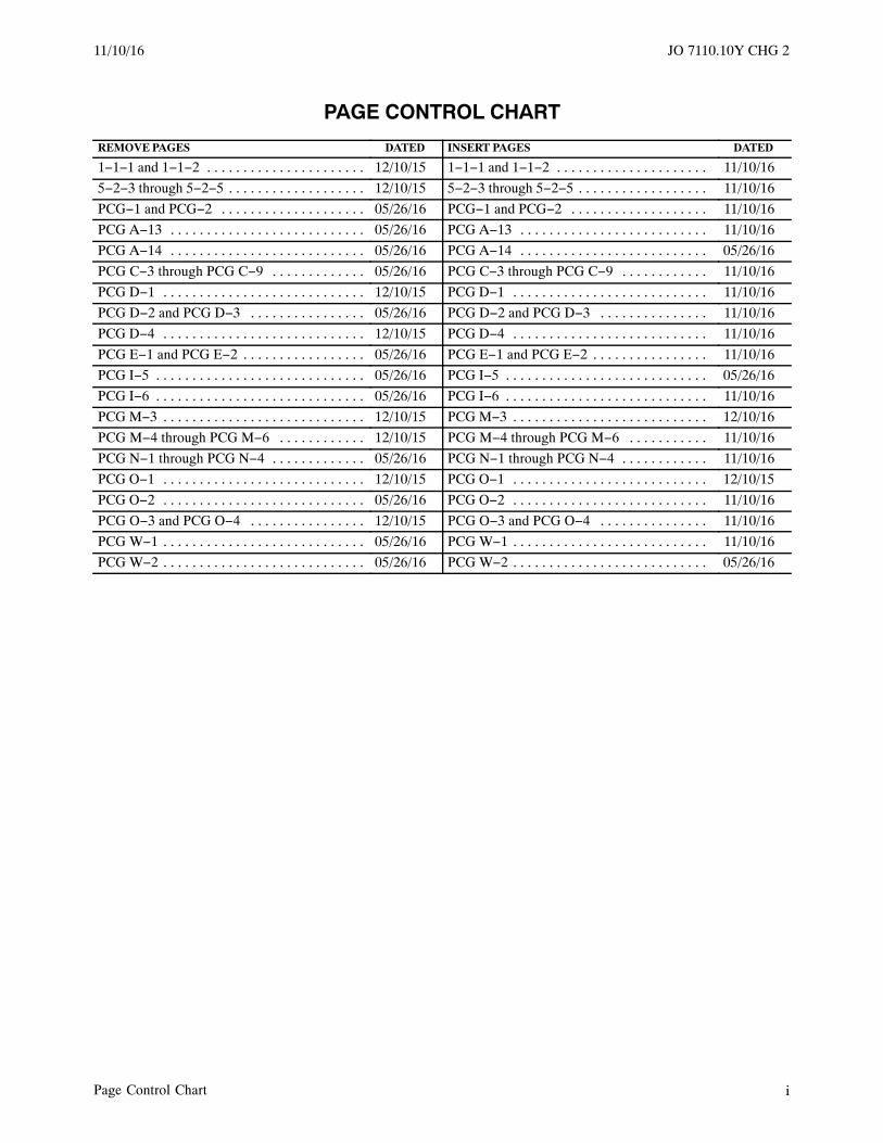
11/10/16 JO 7110.10Y CHG 2
Page Control Chart i
PAGE CONTROL CHART
REMOVE PAGES DATED INSERT PAGES DATED
1−1−1 and 1−1−2 . . . . . . . . . . . . . . . . . . . . . . 12/10/15 1−1−1 and 1−1−2 . . . . . . . . . . . . . . . . . . . . . 11/10/16
5−2−3 through 5−2−5 . . . . . . . . . . . . . . . . . . . 12/10/15 5−2−3 through 5−2−5 . . . . . . . . . . . . . . . . . . 11/10/16
PCG−1 and PCG−2 . . . . . . . . . . . . . . . . . . . . 05/26/16 PCG−1 and PCG−2 . . . . . . . . . . . . . . . . . . . 11/10/16
PCG A−13 . . . . . . . . . . . . . . . . . . . . . . . . . . . 05/26/16 PCG A−13 . . . . . . . . . . . . . . . . . . . . . . . . . . 11/10/16
PCG A−14 . . . . . . . . . . . . . . . . . . . . . . . . . . . 05/26/16 PCG A−14 . . . . . . . . . . . . . . . . . . . . . . . . . . 05/26/16
PCG C−3 through PCG C−9 . . . . . . . . . . . . . 05/26/16 PCG C−3 through PCG C−9 . . . . . . . . . . . . 11/10/16
PCG D−1 . . . . . . . . . . . . . . . . . . . . . . . . . . . . 12/10/15 PCG D−1 . . . . . . . . . . . . . . . . . . . . . . . . . . . 11/10/16
PCG D−2 and PCG D−3 . . . . . . . . . . . . . . . . 05/26/16 PCG D−2 and PCG D−3 . . . . . . . . . . . . . . . 11/10/16
PCG D−4 . . . . . . . . . . . . . . . . . . . . . . . . . . . . 12/10/15 PCG D−4 . . . . . . . . . . . . . . . . . . . . . . . . . . . 11/10/16
PCG E−1 and PCG E−2 . . . . . . . . . . . . . . . . . 05/26/16 PCG E−1 and PCG E−2 . . . . . . . . . . . . . . . . 11/10/16
PCG I−5 . . . . . . . . . . . . . . . . . . . . . . . . . . . . . 05/26/16 PCG I−5 . . . . . . . . . . . . . . . . . . . . . . . . . . . . 05/26/16
PCG I−6 . . . . . . . . . . . . . . . . . . . . . . . . . . . . . 05/26/16 PCG I−6 . . . . . . . . . . . . . . . . . . . . . . . . . . . . 11/10/16
PCG M−3 . . . . . . . . . . . . . . . . . . . . . . . . . . . . 12/10/15 PCG M−3 . . . . . . . . . . . . . . . . . . . . . . . . . . . 12/10/16
PCG M−4 through PCG M−6 . . . . . . . . . . . . 12/10/15 PCG M−4 through PCG M−6 . . . . . . . . . . . 11/10/16
PCG N−1 through PCG N−4 . . . . . . . . . . . . . 05/26/16 PCG N−1 through PCG N−4 . . . . . . . . . . . . 11/10/16
PCG O−1 . . . . . . . . . . . . . . . . . . . . . . . . . . . . 12/10/15 PCG O−1 . . . . . . . . . . . . . . . . . . . . . . . . . . . 12/10/15
PCG O−2 . . . . . . . . . . . . . . . . . . . . . . . . . . . . 05/26/16 PCG O−2 . . . . . . . . . . . . . . . . . . . . . . . . . . . 11/10/16
PCG O−3 and PCG O−4 . . . . . . . . . . . . . . . . 12/10/15 PCG O−3 and PCG O−4 . . . . . . . . . . . . . . . 11/10/16
PCG W−1 . . . . . . . . . . . . . . . . . . . . . . . . . . . . 05/26/16 PCG W−1 . . . . . . . . . . . . . . . . . . . . . . . . . . . 11/10/16
PCG W−2 . . . . . . . . . . . . . . . . . . . . . . . . . . . . 05/26/16 PCG W−2 . . . . . . . . . . . . . . . . . . . . . . . . . . . 05/26/16

JO 7110.10Y12/10/15
1−1−1Introduction
Chapter 1. General
Section 1. Introduction
1−1−1. PURPOSE OF THIS ORDER
This order prescribes procedures and phraseology foruse by air traffic personnel providing flight services.Flight service specialists are required to be familiarwith the provisions of this order that pertain to theiroperational responsibilities and to exercise their bestjudgment if they encounter situations that are notcovered.
1−1−2. AUDIENCE
This order applies to all ATO personnel and anyoneusing ATO directives.
1−1−3. WHERE TO FIND THIS ORDER
This order is available on the FAA Web site athttp://faa.gov/air_traffic/publications and http://em-ployees.faa.gov/tools_resources/orders_notices/.
1−1−4. WHAT THIS ORDER CANCELS
FAA Order 7110.10X, Flight Services, datedApril 3,2014, and all changes to it are canceled.
1−1−5. EXPLANATION OF CHANGES
The significant changes to this order are identified inthe Explanation of Changes page(s). It is advisable toretain the page(s) throughout the duration of the basicorder. If further information is desired, directquestions through the appropriate facility/servicearea office staff to Flight Services Safety andOperations Policy Group.
1−1−6. SUBMISSION CUTOFF ANDEFFECTIVE DATES
This order and its changes are scheduled to bepublished to coincide with AIRAC dates. Theeffective dates will be:
Publication Schedule
Basicor
Change
Cutoff Datefor Submission
Effective Dateof Publication
JO 7110.10Y 6/25/15 12/10/15
Change 1 12/10/15 5/26/16
Change 2 5/26/16 11/10/16
Change 3 11/10/16 4/27/17
JO 7110.10Z 4/27/17 10/12/17
1−1−7. DELIVERY DATES
This order will be available on the FAA’s website 30days prior to its effective date.
All organizations are responsible for viewing,downloading, and subscribing to receive electronicmail notifications when changes occur to this order.Subscriptions can be made at http:/www.faa.gov/air_traffic/publications/.
1−1−8. RECOMMENDATIONS FORPROCEDURAL CHANGES
The responsibility associated with processing andcoordinating revisions to this order is delegated to theDirector, Air Traffic Procedures, AJV-8.
a. Personnel should submit recommendedchanges in procedures to facility management.
b. Recommendations from other sources shouldbe submitted through appropriate FAA, military, orindustry/user channels.
c. Proposed changes must be submittedelectronically to the Air Traffic ProceduresCorrespondence Mailbox at9−AJV−8−HQ−[email protected]. Thesubmission should include a description of therecommended change and the proposed language tobe used in the order.
d. Procedural changes will not be made to thisorder until the operational system software has beenadapted to accomplish the revised procedures.
11/10/16 JO 7110.10Y CHG 2
JO 7110.10Y 12/10/15
1−1−2 Introduction
1−1−9. SUBSCRIPTION INFORMATIONThis publication may be purchased from the U.S.Government Printing Office. Address subscriptioninquiries to:
Superintendent of DocumentsU.S. Government Printing OfficeP.O. Box 979050St. Louis, MO 63197−9000Online: http://bookstore.gpo.gov
FAA air traffic publications are also available on theFAA’s web site at: http://www.faa.gov/air_traffic/publications/
1−1−10. DISTRIBUTION
This order is available online and will be distributedelectronically to all offices that subscribe to receiveemail notification/access to it through the FAA’swebsite (http://www.faa.gov/air_traffic/publica-tions/).
3/15/077110.65R CHG 2JO 7110.10Y CHG 2 11/10/16
JO 7110.10Y12/10/15
5−2−3Operations
a. Obtain the aircraft’s identification and currentposition, and advise the person in charge of the watchof the pilot’s request.
b. Relay the pilot’s request to the FAAWashington Operations Center, AEO-100, (202)267-3333, and provide the aircraft identification andposition.
c. AEO-100 will provide the nearest location.Have AEO-100 standby while the information isrelayed to the pilot.
d. If the pilot wishes to divert to the airportlocation provided, obtain an estimated arrival timefrom the pilot, and advise the person in charge of thewatch.
e. After the aircraft destination has beendetermined, provide the estimated arrival time toAEO-100. AEO−100 will then notify the appropriateairport authority at the diversion airport. In the eventthe K-9 team is not available at this airport, AEO-100will advise the air traffic facility and provide themwith the secondary location. Relay this to the pilotconcerned for appropriate action.
REFERENCE−FAAO 7210.3, Para 2-1-11, Explosives Detection K-9 Teams
5−2−11. INFLIGHT EQUIPMENTMALFUNCTIONS
When a pilot reports an inflight equipmentmalfunction, take the following action:
a. Request the nature and extent of any specialhandling desired.
NOTE−14 CFR Part 91.187 requires the pilot in command of eachaircraft operated in controlled airspace under IFR MUSTreport as soon as practical to ATC any malfunctions ofnavigational, approach, or communication equipmentoccurring in flight. This includes the degree to which thecapability of the aircraft to operate IFR in the air trafficcontrol system is impaired and the nature and extent of anyassistance desired from air traffic control.
b. Provide the maximum assistance possibleconsistent with equipment, workload, and anyspecial handling requested.
c. Relay any special handling required or beingprovided to other specialists or facilities who willsubsequently handle the aircraft.
5−2−12. MINIMUM FUEL
If an aircraft declares a state of “minimum fuel,”inform any facility to whom control jurisdiction istransferred of the minimum fuel problem and be alertfor any occurrence which might delay the aircraft enroute.
NOTE−Use of the term “minimum fuel” indicates recognition bya pilot that the fuel supply has reached a state whereuponreaching destination, any undue delay cannot beaccepted. This is not an emergency situation but merely anadvisory that indicates an emergency situation is possibleshould any undue delay occur. A minimum fuel advisorydoes not imply a need for traffic priority. Common senseand good judgment will determine the extent of assistanceto be given in minimum fuel situations. If, at any time, theremaining usable fuel supply suggests the need for trafficpriority to ensure a safe landing, the pilot should declarean emergency and report fuel remaining in minutes.
5−2−13. AIRCRAFT BOMB THREATS
a. When information is received from any sourcethat a bomb has been placed on, in, or near an aircraftfor the purpose of damaging or destroying suchaircraft, notify the supervisor or facility manager. Ifthe threat is general in nature, handle it as a suspiciousactivity. When the threat is targeted against a specificaircraft and you are in contact with that aircraft, takethe following actions as appropriate:
NOTE−1. Facility supervisors are expected to notify theappropriate offices, agencies, and operators/air carriersaccording to applicable plans, directives, FAA Order JO7210.3, Facility Operation and Administration, ormilitary directives.
2. Suspicious activity is covered in FAA Order JO 7610.4,Chapter 7, Hijacked/Suspicious Aircraft Reporting andProcedures. Military facilities would report a generalthreat through the chain of command or according toservice directives.
REFERENCE−FAAO JO 7610.4, Chapter 7, Hijacked/Suspicious Aircraft Reporting andProcedures.
3. A specific threat may be directed at an aircraft registryor tail number, the air carrier flight number, the name ofan operator, crew member or passenger, the departure/ar-rival point or times, or combinations thereof.
1. Advise the pilot of the threat.
2. Report the threat to the Domestic EventsNetwork (DEN) Air Traffic Security Coordinator(ATSC) via (202) 267-4700. Also, an additional
11/10/16 JO 7110.10Y CHG 2
JO 7110.10Y 12/10/15
5−2−4 Operations
toll−free number is available to contact the DEN. Thenew toll−free number is 844−432−2962. Either phonenumber may be used to contact the DEN. If unable tocontact the DEN ATSC notify the TransportationSecurity Administration/Transportation SecurityOperation Center (TSA/TSOC) directly at703-563-3400.
3. Ask if the pilot desires to climb or descend toan altitude that would equalize or reduce the outsideair pressure/existing cabin air pressure differential.Obtain and relay an appropriate clearance consider-ing minimum en route altitude (MEA), minimumobstruction clearance altitude (MOCA), minimumreception altitude (MRA), and weather.
NOTE−Equalizing existing cabin air pressure with outside airpressure is a key step which the pilot may wish to take tominimize the damage potential of a bomb.
4. Handle the aircraft as an emergency, and/orprovide the most expeditious handling possible withrespect to the safety of other aircraft, weatherconditions, ground facilities, and personnel.
NOTE−Emergency handling is discretionary and should be basedon the situation. With certain types of threats, plans maycall for a low-key action or response.
5. Obtain and relay clearance to a newdestination, if requested.
6. When a pilot requests technical assistance orif it is apparent that such assistance is needed, doNOT suggest what actions the pilot should takeconcerning a bomb, but obtain the followinginformation and notify the supervisor who willcontact the DEN ATSC or TSA/TSOC as explainedin a2 above.
NOTE−This information is needed by TSA explosives experts sothat the situation can be assessed and immediaterecommendations made to the pilot. The aviationexplosives experts may not be familiar with all militaryaircraft configurations but can offer technical assistancewhich would be beneficial to the pilot.
(a) Type, series, and model of the aircraft.
(b) Precise location/description of the bombdevice, if known.
(c) Other details which may be pertinent.
b. When a bomb threat involves an aircraft on theground and you are in contact with the suspectaircraft, take the following actions in addition tothose discussed in the preceding paragraphs whichmay be appropriate:
1. If the pilot ignores the threat, recommend thattakeoff be delayed until the pilot or aircraft operatorestablishes that a bomb is not aboard.
2. Advise the aircraft to remain as far away fromother aircraft and facilities as possible, to clear therunway, if appropriate, and to taxi to an isolated ordesignated search area. When it is impractical or if thepilot takes an alternative action, such as parking andoffloading immediately, advise other aircraft toremain clear of the suspect aircraft by at least100 yards, if able.
NOTE−Passenger deplaning may be of paramount importanceand must be considered before the aircraft is parked ormoved away from the service areas. The decision to useramp facilities rests with the pilot, aircraft operator,and/or airport manager.
c. If you are unable to inform the suspect aircraftof a bomb threat or if you lose contact with theaircraft, advise your supervisor to contact the DENATSC for relay of pertinent details to other sectors orfacilities, as deemed necessary.
d. When a pilot reports the discovery of a bomb orsuspected bomb on an aircraft, determine the pilot’sintentions and comply with his/her requests insofar aspossible. Take all the actions discussed in thepreceding paragraphs which may be appropriateunder the existing circumstances.
e. The handling of aircraft when a hijacker has oris suspected of having a bomb requires specialconsiderations. Be responsive to the pilot’s requestsand notify supervisory personnel. Apply hijackingprocedures in accordance with FAA Order JO 7610.4,Special Operations, Chapter 7, and if needed, offerassistance to the pilot according to the precedingparagraphs.
5−2−14. EMERGENCY SECURITYCONTROL OF AIR TRAFFIC (ESCAT)
a. 32 CFR 245 Plan for the Emergency SecurityControl of Air Traffic (ESCAT) outlinesresponsibilities, procedures, and instructions for thesecurity control of civil and military air traffic undervarious emergency conditions.
3/15/077110.65R CHG 2JO 7110.10Y CHG 2 11/10/16
JO 7110.10Y12/10/15
5−2−5Operations
b. When notified of ESCAT implementation,follow the instructions received from the Air TrafficControl System Command Center (ATCSCC),ARTCC, and/or Domestic Events Network (DEN) airtraffic security coordinator (ATSC).
1. To ensure that ESCAT actions can be takenexpeditiously, periodic ESCAT tests will beconducted in connection with NORAD exercises.
Tests may be local, regional, or national in scope.
2. FSS must participate in tests except wheresuch participation will involve the safety of aircraft.
3. During ESCAT tests, all actions will besimulated.REFERENCE−FAAO JO 7610.4, Chapter 6, Emergency Security Controlof Air Traffic (ESCAT).
11/10/16 JO 7110.10Y CHG 2

Pilot/Controller Glossary11/10/16
PCG−1
PILOT/CONTROLLERGLOSSARY
PURPOSE
a. This Glossary was compiled to promote a common understanding of the terms used in the Air TrafficControl system. It includes those terms which are intended for pilot/controller communications. Those termsmost frequently used in pilot/controller communications are printed in bold italics. The definitions are primarilydefined in an operational sense applicable to both users and operators of the National Airspace System. Use ofthe Glossary will preclude any misunderstandings concerning the system’s design, function, and purpose.
b. Because of the international nature of flying, terms used in the Lexicon, published by the InternationalCivil Aviation Organization (ICAO), are included when they differ from FAA definitions. These terms arefollowed by “[ICAO].” For the reader’s convenience, there are also cross references to related terms in other partsof the Glossary and to other documents, such as the Code of Federal Regulations (CFR) and the AeronauticalInformation Manual (AIM).
c. This Glossary will be revised, as necessary, to maintain a common understanding of the system.
EXPLANATION OF CHANGES
d. Terms Added:CONDITIONS NOT MONITOREDDATA LINK AUTOMATIC TERMINAL INFORMATION SERVICE (D−ATIS) [ICAO]ENHANCED FLIGHT VISION SYSTEM (EFVS)ESTIMATED (EST)IRREGULAR SURFACEMODEL AIRCRAFT NORTH ATLANTIC HIGH LEVEL AIRSPACE (NAT HLA)NOT STANDARD (NOT STD)OUT OF SERVICE
e. Terms Deleted:MINIMUM NAVIGATION PERFORMANCE SPECIFICATION (MNPS)MINIMUM NAVIGATION PERFORMANCE SPECIFICATION AIRSPACE (MNPSA)
f. Terms Modified:CLEARED FOR THE OPTION OPTION APPROACH
g. Editorial/format changes were made where necessary. Revision bars were not used due to the insignificantnature of the changes.

Pilot/Controller Glossary12/10/15
PCG A−13
ARRIVAL AIRCRAFT INTERVAL− An internallygenerated program in hundredths of minutes basedupon the AAR. AAI is the desired optimum intervalbetween successive arrival aircraft over the vertex.
ARRIVAL CENTER− The ARTCC having jurisdic-tion for the impacted airport.
ARRIVAL DELAY− A parameter which specifies aperiod of time in which no aircraft will be metered forarrival at the specified airport.
ARRIVAL SECTOR− An operational control sectorcontaining one or more meter fixes.
ARRIVAL SECTOR ADVISORY LIST− Anordered list of data on arrivals displayed at thePVD/MDM of the sector which controls the meterfix.
ARRIVAL SEQUENCING PROGRAM− The auto-mated program designed to assist in sequencingaircraft destined for the same airport.
ARRIVAL TIME− The time an aircraft touches downon arrival.
ARSR−(See AIR ROUTE SURVEILLANCE RADAR.)
ARTCC−(See AIR ROUTE TRAFFIC CONTROLCENTER.)
ARTS−(See AUTOMATED RADAR TERMINALSYSTEMS.)
ASDA−(See ACCELERATE-STOP DISTANCEAVAILABLE.)
ASDA [ICAO]−(See ICAO Term ACCELERATE-STOPDISTANCE AVAILABLE.)
ASDE−(See AIRPORT SURFACE DETECTIONEQUIPMENT.)
ASF−(See AIRPORT STREAM FILTER.)
ASLAR−(See AIRCRAFT SURGE LAUNCH ANDRECOVERY.)
ASP−(See ARRIVAL SEQUENCING PROGRAM.)
ASR−(See AIRPORT SURVEILLANCE RADAR.)
ASR APPROACH−(See SURVEILLANCE APPROACH.)
ASSOCIATED− A radar target displaying a datablock with flight identification and altitudeinformation.
(See UNASSOCIATED.)
ATC−(See AIR TRAFFIC CONTROL.)
ATC ADVISES− Used to prefix a message ofnoncontrol information when it is relayed to anaircraft by other than an air traffic controller.
(See ADVISORY.)
ATC ASSIGNED AIRSPACE− Airspace of definedvertical/lateral limits, assigned by ATC, for thepurpose of providing air traffic segregation betweenthe specified activities being conducted within theassigned airspace and other IFR air traffic.
(See SPECIAL USE AIRSPACE.)
ATC CLEARANCE−(See AIR TRAFFIC CLEARANCE.)
ATC CLEARS− Used to prefix an ATC clearancewhen it is relayed to an aircraft by other than an airtraffic controller.
ATC INSTRUCTIONS− Directives issued by airtraffic control for the purpose of requiring a pilot totake specific actions; e.g., “Turn left heading two fivezero,” “Go around,” “Clear the runway.”
(Refer to 14 CFR Part 91.)
ATC PREFERRED ROUTE NOTIFICATION−EDST notification to the appropriate controller of theneed to determine if an ATC preferred route needs tobe applied, based on destination airport.
(See ROUTE ACTION NOTIFICATION.)(See EN ROUTE DECISION SUPPORTTOOL.)
ATC PREFERRED ROUTES− Preferred routes thatare not automatically applied by Host.
ATC REQUESTS− Used to prefix an ATC requestwhen it is relayed to an aircraft by other than an airtraffic controller.
ATC SECURITY SERVICES − Communicationsand security tracking provided by an ATC facility insupport of the DHS, the DOD, or other Federalsecurity elements in the interest of national security.
11/10/16 Pilot/Controller Glossary

Pilot/Controller Glossary 12/10/15
PCG A−14
Such security services are only applicable withindesignated areas. ATC security services do notinclude ATC basic radar services or flight following.
ATC SECURITY SERVICES POSITION − Theposition responsible for providing ATC securityservices as defined. This position does not provideATC, IFR separation, or VFR flight followingservices, but is responsible for providing securityservices in an area comprising airspace assigned toone or more ATC operating sectors. This positionmay be combined with control positions.
ATC SECURITY TRACKING− The continuoustracking of aircraft movement by an ATC facility insupport of the DHS, the DOD, or other securityelements for national security using radar (i.e., radartracking) or other means (e.g., manual tracking)without providing basic radar services (includingtraffic advisories) or other ATC services not definedin this section.
ATC SURVEILLANCE SOURCE– Used by ATCfor establishing identification, control and separationusing a target depicted on an air traffic controlfacility’s video display that has met the relevantsafety standards for operational use and receivedfrom one, or a combination, of the followingsurveillance sources:a. Radar (See RADAR)b. ADS-B (See AUTOMATIC DEPENDENTSURVEILLANCE BROADCAST.)c. WAM (See WIDE AREA MULTILATERATION)
(See INTERROGATOR.)(See TRANSPONDER.)(See ICAO term RADAR.)(Refer to AIM.)
ATCAA−(See ATC ASSIGNED AIRSPACE.)
ATCRBS−(See RADAR.)
ATCSCC−(See AIR TRAFFIC CONTROL SYSTEMCOMMAND CENTER.)
ATCT−(See TOWER.)
ATD−(See ALONG−TRACK DISTANCE.)
ATIS−(See AUTOMATIC TERMINAL INFORMATIONSERVICE.)
ATIS [ICAO]−(See ICAO Term AUTOMATIC TERMINALINFORMATION SERVICE.)
ATS ROUTE [ICAO]− A specified route designed forchanneling the flow of traffic as necessary for theprovision of air traffic services.
Note: The term “ATS Route” is used to mean vari-ously, airway, advisory route, controlled oruncontrolled route, arrival or departure, etc.
ATTENTION ALL USERS PAGE (AAUP)- TheAAUP provides the pilot with additional informationrelative to conducting a specific operation, forexample, PRM approaches and RNAV departures.
AUTOLAND APPROACH−An autoland systemaids by providing control of aircraft systems duringa precision instrument approach to at least decisionaltitude and possibly all the way to touchdown, aswell as in some cases, through the landing rollout.The autoland system is a sub-system of the autopilotsystem from which control surface managementoccurs. The aircraft autopilot sends instructions to theautoland system and monitors the autoland systemperformance and integrity during its execution.
AUTOMATED INFORMATION TRANSFER− Aprecoordinated process, specifically defined infacility directives, during which a transfer of altitudecontrol and/or radar identification is accomplishedwithout verbal coordination between controllersusing information communicated in a full data block.
AUTOMATED MUTUAL-ASSISTANCE VESSELRESCUE SYSTEM− A facility which can deliver, ina matter of minutes, a surface picture (SURPIC) ofvessels in the area of a potential or actual search andrescue incident, including their predicted positionsand their characteristics.
(See FAAO JO 7110.65, Para 10−6−4, INFLIGHTCONTINGENCIES.)
AUTOMATED PROBLEM DETECTION (APD)−An Automation Processing capability that comparestrajectories in order to predict conflicts.
AUTOMATED PROBLEM DETECTIONBOUNDARY (APB)− The adapted distance beyonda facilities boundary defining the airspace withinwhich EDST performs conflict detection.
(See EN ROUTE DECISION SUPPORT TOOL.)
Pilot/Controller Glossary 5/26/16
Pilot/Controller Glossary12/10/15
PCG C−3
associated with wind shear. CAT is often encounteredin the vicinity of the jet stream.
(See WIND SHEAR.)(See JET STREAM.)
CLEAR OF THE RUNWAY−
a. Taxiing aircraft, which is approaching arunway, is clear of the runway when all parts of theaircraft are held short of the applicable runwayholding position marking.
b. A pilot or controller may consider an aircraft,which is exiting or crossing a runway, to be clear ofthe runway when all parts of the aircraft are beyondthe runway edge and there are no restrictions to itscontinued movement beyond the applicable runwayholding position marking.
c. Pilots and controllers shall exercise goodjudgement to ensure that adequate separation existsbetween all aircraft on runways and taxiways atairports with inadequate runway edge lines orholding position markings.
CLEARANCE−(See AIR TRAFFIC CLEARANCE.)
CLEARANCE LIMIT− The fix, point, or location towhich an aircraft is cleared when issued an air trafficclearance.
(See ICAO term CLEARANCE LIMIT.)
CLEARANCE LIMIT [ICAO]− The point to whichan aircraft is granted an air traffic control clearance.
CLEARANCE VOID IF NOT OFF BY (TIME)−Used by ATC to advise an aircraft that the departureclearance is automatically canceled if takeoff is notmade prior to a specified time. The pilot must obtaina new clearance or cancel his/her IFR flight plan if notoff by the specified time.
(See ICAO term CLEARANCE VOID TIME.)
CLEARANCE VOID TIME [ICAO]− A timespecified by an air traffic control unit at which aclearance ceases to be valid unless the aircraftconcerned has already taken action to complytherewith.
CLEARED APPROACH− ATC authorization for anaircraft to execute any standard or special instrumentapproach procedure for that airport. Normally, an
aircraft will be cleared for a specific instrumentapproach procedure.
(See CLEARED (Type of) APPROACH.)(See INSTRUMENT APPROACHPROCEDURE.)
(Refer to 14 CFR Part 91.)(Refer to AIM.)
CLEARED (Type of) APPROACH− ATC authoriza-tion for an aircraft to execute a specific instrumentapproach procedure to an airport; e.g., “Cleared ILSRunway Three Six Approach.”
(See APPROACH CLEARANCE.)(See INSTRUMENT APPROACHPROCEDURE.)
(Refer to 14 CFR Part 91.)(Refer to AIM.)
CLEARED AS FILED− Means the aircraft is clearedto proceed in accordance with the route of flight filedin the flight plan. This clearance does not include thealtitude, DP, or DP Transition.
(See REQUEST FULL ROUTE CLEARANCE.)(Refer to AIM.)
CLEARED FOR TAKEOFF− ATC authorizationfor an aircraft to depart. It is predicated on knowntraffic and known physical airport conditions.
CLEARED FOR THE OPTION− ATC authoriza-tion for an aircraft to make a touch-and-go, lowapproach, missed approach, stop and go, or full stoplanding at the discretion of the pilot. It is normallyused in training so that an instructor can evaluate astudent’s performance under changing situations.Pilots should advise ATC if they decide to remain onthe runway, of any delay in their stop and go, delayclearing the runway, or are unable to comply with theinstruction(s).
(See OPTION APPROACH.)(Refer to AIM.)
CLEARED THROUGH− ATC authorization for anaircraft to make intermediate stops at specifiedairports without refiling a flight plan while en routeto the clearance limit.
CLEARED TO LAND− ATC authorization for anaircraft to land. It is predicated on known traffic andknown physical airport conditions.
CLEARWAY− An area beyond the takeoff runwayunder the control of airport authorities within whichterrain or fixed obstacles may not extend above
11/10/16 Pilot/Controller Glossary
Pilot/Controller Glossary 12/10/15
PCG C−4
specified limits. These areas may be required forcertain turbine-powered operations and the size andupward slope of the clearway will differ depending onwhen the aircraft was certificated.
(Refer to 14 CFR Part 1.)
CLIMB TO VFR− ATC authorization for an aircraftto climb to VFR conditions within Class B, C, D, andE surface areas when the only weather limitation isrestricted visibility. The aircraft must remain clear ofclouds while climbing to VFR.
(See SPECIAL VFR CONDITIONS.)(Refer to AIM.)
CLIMBOUT− That portion of flight operationbetween takeoff and the initial cruising altitude.
CLIMB VIA– An abbreviated ATC clearance thatrequires compliance with the procedure lateral path,associated speed restrictions, and altitude restrictionsalong the cleared route or procedure.
CLOSE PARALLEL RUNWAYS− Two parallelrunways whose extended centerlines are separated byless than 4,300 feet and at least 3000 feet (750 feet forSOIA operations) that are authorized to conductsimultaneous independent approach operations.PRM and simultaneous close parallel appear inapproach title. Dual communications, special pilottraining, an Attention All Users Page (AAUP), NTZmonitoring by displays that have aural and visualalerting algorithms are required. A high update ratesurveillance sensor is required for certain runway orapproach course spacing.
CLOSED RUNWAY− A runway that is unusable foraircraft operations. Only the airport management/military operations office can close a runway.
CLOSED TRAFFIC− Successive operations involv-ing takeoffs and landings or low approaches wherethe aircraft does not exit the traffic pattern.
CLOUD− A cloud is a visible accumulation ofminute water droplets and/or ice particles in theatmosphere above the Earth’s surface. Cloud differsfrom ground fog, fog, or ice fog only in that the latterare, by definition, in contact with the Earth’s surface.
CLT−(See CALCULATED LANDING TIME.)
CLUTTER− In radar operations, clutter refers to thereception and visual display of radar returns caused
by precipitation, chaff, terrain, numerous aircrafttargets, or other phenomena. Such returns may limitor preclude ATC from providing services based onradar.
(See CHAFF.)(See GROUND CLUTTER.)(See PRECIPITATION.)(See TARGET.)(See ICAO term RADAR CLUTTER.)
CMNPS−(See CANADIAN MINIMUM NAVIGATIONPERFORMANCE SPECIFICATION AIRSPACE.)
COASTAL FIX− A navigation aid or intersectionwhere an aircraft transitions between the domesticroute structure and the oceanic route structure.
CODES− The number assigned to a particularmultiple pulse reply signal transmitted by atransponder.
(See DISCRETE CODE.)
COLD TEMPERATURE COMPENSATION− Anaction on the part of the pilot to adjust an aircraft’sindicated altitude due to the effect of coldtemperatures on true altitude above terrain versusaircraft indicated altitude. The amount ofcompensation required increases at a greater rate witha decrease in temperature and increase in heightabove the reporting station.
COLLABORATIVE TRAJECTORY OPTIONSPROGRAM (CTOP)- CTOP is a traffic managementprogram administered by the Air Traffic ControlSystem Command Center (ATCSCC) that managesdemand through constrained airspace, while consid-ering operator preference with regard to both routeand delay as defined in a Trajectory Options Set(TOS).
COMBINED CENTER-RAPCON− An air trafficfacility which combines the functions of an ARTCCand a radar approach control facility.
(See AIR ROUTE TRAFFIC CONTROLCENTER.)
(See RADAR APPROACH CONTROLFACILITY.)
COMMON POINT− A significant point over whichtwo or more aircraft will report passing or havereported passing before proceeding on the same ordiverging tracks. To establish/maintain longitudinalseparation, a controller may determine a common
Pilot/Controller Glossary 11/10/16
Pilot/Controller Glossary12/10/15
PCG C−5
point not originally in the aircraft’s flight plan andthen clear the aircraft to fly over the point.
(See SIGNIFICANT POINT.)
COMMON PORTION−(See COMMON ROUTE.)
COMMON ROUTE− That segment of a NorthAmerican Route between the inland navigationfacility and the coastal fix.
OR
COMMON ROUTE− Typically the portion of aRNAV STAR between the en route transition endpoint and the runway transition start point; however,the common route may only consist of a single pointthat joins the en route and runway transitions.
COMMON TRAFFIC ADVISORY FREQUENCY(CTAF)− A frequency designed for the purpose ofcarrying out airport advisory practices whileoperating to or from an airport without an operatingcontrol tower. The CTAF may be a UNICOM,Multicom, FSS, or tower frequency and is identifiedin appropriate aeronautical publications.
(See DESIGNATED COMMON TRAFFICADVISORY FREQUENCY (CTAF) AREA.)
(Refer to AC 90-42, Traffic Advisory Practices atAirports Without Operating Control Towers.)
COMPASS LOCATOR− A low power, low ormedium frequency (L/MF) radio beacon installed atthe site of the outer or middle marker of an instrumentlanding system (ILS). It can be used for navigation atdistances of approximately 15 miles or as authorizedin the approach procedure.
a. Outer Compass Locator (LOM)− A compasslocator installed at the site of the outer marker of aninstrument landing system.
(See OUTER MARKER.)
b. Middle Compass Locator (LMM)− A compasslocator installed at the site of the middle marker of aninstrument landing system.
(See MIDDLE MARKER.)(See ICAO term LOCATOR.)
COMPASS ROSE− A circle, graduated in degrees,printed on some charts or marked on the ground at anairport. It is used as a reference to either true ormagnetic direction.
COMPLY WITH RESTRICTIONS− An ATCinstruction that requires an aircraft being vectoredback onto an arrival or departure procedure to comply
with all altitude and/or speed restrictions depicted onthe procedure. This term may be used in lieu ofrepeating each remaining restriction that appears onthe procedure.
COMPOSITE FLIGHT PLAN− A flight plan whichspecifies VFR operation for one portion of flight andIFR for another portion. It is used primarily inmilitary operations.
(Refer to AIM.)
COMPOSITE ROUTE SYSTEM− An organizedoceanic route structure, incorporating reduced lateralspacing between routes, in which compositeseparation is authorized.
COMPOSITE SEPARATION− A method of separat-ing aircraft in a composite route system where, bymanagement of route and altitude assignments, acombination of half the lateral minimum specified forthe area concerned and half the vertical minimum isapplied.
COMPULSORY REPORTING POINTS− Reportingpoints which must be reported to ATC. They aredesignated on aeronautical charts by solid triangles orfiled in a flight plan as fixes selected to define directroutes. These points are geographical locationswhich are defined by navigation aids/fixes. Pilotsshould discontinue position reporting over compul-sory reporting points when informed by ATC thattheir aircraft is in “radar contact.”
CONDITIONS NOT MONITORED−When anairport operator cannot monitor the condition of themovement area or airfield surface area, thisinformation is issued as a NOTAM. Usuallynecessitated due to staffing, operating hours or othermitigating factors associated with airport operations.
CONFIDENCE MANEUVER− A confidence man-euver consists of one or more turns, a climb ordescent, or other maneuver to determine if the pilotin command (PIC) is able to receive and comply withATC instructions.
CONFLICT ALERT− A function of certain air trafficcontrol automated systems designed to alert radarcontrollers to existing or pending situations betweentracked targets (known IFR or VFR aircraft) thatrequire his/her immediate attention/action.
(See MODE C INTRUDER ALERT.)
CONFLICT RESOLUTION− The resolution ofpotential conflictions between aircraft that are radaridentified and in communication with ATC by
11/10/16 Pilot/Controller Glossary
Pilot/Controller Glossary 12/10/15
PCG C−6
ensuring that radar targets do not touch. Pertinenttraffic advisories shall be issued when this procedureis applied.
Note: This procedure shall not be provided utilizingmosaic radar systems.
CONFORMANCE− The condition established whenan aircraft’s actual position is within the conformanceregion constructed around that aircraft at its position,according to the trajectory associated with theaircraft’s Current Plan.
CONFORMANCE REGION− A volume, boundedlaterally, vertically, and longitudinally, within whichan aircraft must be at a given time in order to be inconformance with the Current Plan Trajectory for thataircraft. At a given time, the conformance region isdetermined by the simultaneous application of thelateral, vertical, and longitudinal conformancebounds for the aircraft at the position defined by timeand aircraft’s trajectory.
CONSOLAN− A low frequency, long-distanceNAVAID used principally for transoceanic naviga-tions.
CONTACT−
a. Establish communication with (followed by thename of the facility and, if appropriate, the frequencyto be used).
b. A flight condition wherein the pilot ascertainsthe attitude of his/her aircraft and navigates by visualreference to the surface.
(See CONTACT APPROACH.)(See RADAR CONTACT.)
CONTACT APPROACH− An approach wherein anaircraft on an IFR flight plan, having an air trafficcontrol authorization, operating clear of clouds withat least 1 mile flight visibility and a reasonableexpectation of continuing to the destination airport inthose conditions, may deviate from the instrumentapproach procedure and proceed to the destinationairport by visual reference to the surface. Thisapproach will only be authorized when requested bythe pilot and the reported ground visibility at thedestination airport is at least 1 statute mile.
(Refer to AIM.)
CONTAMINATED RUNWAY− A runway isconsidered contaminated whenever standing water,ice, snow, slush, frost in any form, heavy rubber, orother substances are present. A runway is contami-
nated with respect to rubber deposits or otherfriction-degrading substances when the averagefriction value for any 500-foot segment of the runwaywithin the ALD fails below the recommendedminimum friction level and the average friction valuein the adjacent 500-foot segments falls below themaintenance planning friction level.
CONTERMINOUS U.S.− The 48 adjoining Statesand the District of Columbia.
CONTINENTAL UNITED STATES− The 49 Stateslocated on the continent of North America and theDistrict of Columbia.
CONTINUE− When used as a control instructionshould be followed by another word or wordsclarifying what is expected of the pilot. Example:“continue taxi,” “continue descent,” “continueinbound,” etc.
CONTROL AREA [ICAO]− A controlled airspaceextending upwards from a specified limit above theearth.
CONTROL SECTOR− An airspace area of definedhorizontal and vertical dimensions for which acontroller or group of controllers has air trafficcontrol responsibility, normally within an air routetraffic control center or an approach control facility.Sectors are established based on predominant trafficflows, altitude strata, and controller workload.Pilot-communications during operations within asector are normally maintained on discrete frequen-cies assigned to the sector.
(See DISCRETE FREQUENCY.)
CONTROL SLASH− A radar beacon slash repre-senting the actual position of the associated aircraft.Normally, the control slash is the one closest to theinterrogating radar beacon site. When ARTCC radaris operating in narrowband (digitized) mode, thecontrol slash is converted to a target symbol.
CONTROLLED AIRSPACE− An airspace ofdefined dimensions within which air traffic controlservice is provided to IFR flights and to VFR flightsin accordance with the airspace classification.
a. Controlled airspace is a generic term that coversClass A, Class B, Class C, Class D, and Class Eairspace.
b. Controlled airspace is also that airspace withinwhich all aircraft operators are subject to certain pilotqualifications, operating rules, and equipmentrequirements in 14 CFR Part 91 (for specific
Pilot/Controller Glossary 11/10/16
Pilot/Controller Glossary12/10/15
PCG C−7
operating requirements, please refer to 14 CFRPart 91). For IFR operations in any class of controlledairspace, a pilot must file an IFR flight plan andreceive an appropriate ATC clearance. Each Class B,Class C, and Class D airspace area designated for anairport contains at least one primary airport aroundwhich the airspace is designated (for specificdesignations and descriptions of the airspace classes,please refer to 14 CFR Part 71).
c. Controlled airspace in the United States isdesignated as follows:
1. CLASS A− Generally, that airspace from18,000 feet MSL up to and including FL 600,including the airspace overlying the waters within 12nautical miles of the coast of the 48 contiguous Statesand Alaska. Unless otherwise authorized, all personsmust operate their aircraft under IFR.
2. CLASS B− Generally, that airspace from thesurface to 10,000 feet MSL surrounding the nation’sbusiest airports in terms of airport operations orpassenger enplanements. The configuration of eachClass B airspace area is individually tailored andconsists of a surface area and two or more layers(some Class B airspaces areas resemble upside-downwedding cakes), and is designed to contain allpublished instrument procedures once an aircraftenters the airspace. An ATC clearance is required forall aircraft to operate in the area, and all aircraft thatare so cleared receive separation services within theairspace. The cloud clearance requirement for VFRoperations is “clear of clouds.”
3. CLASS C− Generally, that airspace from thesurface to 4,000 feet above the airport elevation(charted in MSL) surrounding those airports thathave an operational control tower, are serviced by aradar approach control, and that have a certainnumber of IFR operations or passenger enplane-ments. Although the configuration of each Class Carea is individually tailored, the airspace usuallyconsists of a surface area with a 5 nautical mile (NM)radius, a circle with a 10NM radius that extends nolower than 1,200 feet up to 4,000 feet above theairport elevation and an outer area that is not charted.Each person must establish two-way radio commu-nications with the ATC facility providing air trafficservices prior to entering the airspace and thereaftermaintain those communications while within theairspace. VFR aircraft are only separated from IFRaircraft within the airspace.
(See OUTER AREA.)
4. CLASS D− Generally, that airspace from thesurface to 2,500 feet above the airport elevation(charted in MSL) surrounding those airports thathave an operational control tower. The configurationof each Class D airspace area is individually tailoredand when instrument procedures are published, theairspace will normally be designed to contain theprocedures. Arrival extensions for instrumentapproach procedures may be Class D or Class Eairspace. Unless otherwise authorized, each personmust establish two-way radio communications withthe ATC facility providing air traffic services prior toentering the airspace and thereafter maintain thosecommunications while in the airspace. No separationservices are provided to VFR aircraft.
5. CLASS E− Generally, if the airspace is notClass A, Class B, Class C, or Class D, and it iscontrolled airspace, it is Class E airspace. Class Eairspace extends upward from either the surface or adesignated altitude to the overlying or adjacentcontrolled airspace. When designated as a surfacearea, the airspace will be configured to contain allinstrument procedures. Also in this class are Federalairways, airspace beginning at either 700 or 1,200feet AGL used to transition to/from the terminal or enroute environment, en route domestic, and offshoreairspace areas designated below 18,000 feet MSL.Unless designated at a lower altitude, Class Eairspace begins at 14,500 MSL over the UnitedStates, including that airspace overlying the waterswithin 12 nautical miles of the coast of the 48contiguous States and Alaska, up to, but notincluding 18,000 feet MSL, and the airspace aboveFL 600.
CONTROLLED AIRSPACE [ICAO]− An airspaceof defined dimensions within which air traffic controlservice is provided to IFR flights and to VFR flightsin accordance with the airspace classification.
Note: Controlled airspace is a generic term whichcovers ATS airspace Classes A, B, C, D, and E.
CONTROLLED TIME OF ARRIVAL− Arrival timeassigned during a Traffic Management Program. Thistime may be modified due to adjustments or useroptions.
CONTROLLER−(See AIR TRAFFIC CONTROL SPECIALIST.)
CONTROLLER [ICAO]− A person authorized toprovide air traffic control services.
11/10/16 Pilot/Controller Glossary
Pilot/Controller Glossary 12/10/15
PCG C−8
CONTROLLER PILOT DATA LINKCOMMUNICATIONS (CPDLC)− A two−waydigital communications system that conveys textualair traffic control messages between controllers andpilots using ground or satellite-based radio relaystations.
CONVECTIVE SIGMET− A weather advisoryconcerning convective weather significant to thesafety of all aircraft. Convective SIGMETs are issuedfor tornadoes, lines of thunderstorms, embeddedthunderstorms of any intensity level, areas ofthunderstorms greater than or equal to VIP level 4with an area coverage of 4/10 (40%) or more, and hail3/4 inch or greater.
(See AIRMET.)(See AWW.)(See CWA.)(See SIGMET.)(Refer to AIM.)
CONVECTIVE SIGNIFICANT METEOROLOG-ICAL INFORMATION−
(See CONVECTIVE SIGMET.)
COORDINATES− The intersection of lines ofreference, usually expressed in degrees/minutes/seconds of latitude and longitude, used to determineposition or location.
COORDINATION FIX− The fix in relation to whichfacilities will handoff, transfer control of an aircraft,or coordinate flight progress data. For terminalfacilities, it may also serve as a clearance for arrivingaircraft.
COPTER−(See HELICOPTER.)
CORRECTION− An error has been made in thetransmission and the correct version follows.
COUPLED APPROACH− An instrument approachperformed by the aircraft autopilot, and/or visuallydepicted on the flight director, which is receivingposition information and/or steering commands fromonboard navigational equipment. In general, couplednon-precision approaches must be flown manually(autopilot disengaged) at altitudes lower than 50 feetAGL below the minimum descent altitude, andcoupled precision approaches must be flownmanually (autopilot disengaged) below 50 feet AGLunless authorized to conduct autoland operations.
Coupled instrument approaches are commonly flownto the allowable IFR weather minima established bythe operator or PIC, or flown VFR for training andsafety.
COURSE−
a. The intended direction of flight in the horizontalplane measured in degrees from north.
b. The ILS localizer signal pattern usuallyspecified as the front course or the back course.
(See BEARING.)(See INSTRUMENT LANDING SYSTEM.)(See RADIAL.)
CPDLC−(See CONTROLLER PILOT DATA LINKCOMMUNICATIONS.)
CPL [ICAO]−(See ICAO term CURRENT FLIGHT PLAN.)
CRITICAL ENGINE− The engine which, uponfailure, would most adversely affect the performanceor handling qualities of an aircraft.
CROSS (FIX) AT (ALTITUDE)− Used by ATCwhen a specific altitude restriction at a specified fixis required.
CROSS (FIX) AT OR ABOVE (ALTITUDE)− Usedby ATC when an altitude restriction at a specified fixis required. It does not prohibit the aircraft fromcrossing the fix at a higher altitude than specified;however, the higher altitude may not be one that willviolate a succeeding altitude restriction or altitudeassignment.
(See ALTITUDE RESTRICTION.)(Refer to AIM.)
CROSS (FIX) AT OR BELOW (ALTITUDE)−Used by ATC when a maximum crossing altitude ata specific fix is required. It does not prohibit theaircraft from crossing the fix at a lower altitude;however, it must be at or above the minimum IFRaltitude.
(See ALTITUDE RESTRICTION.)(See MINIMUM IFR ALTITUDES.)(Refer to 14 CFR Part 91.)
CROSSWIND−
a. When used concerning the traffic pattern, theword means “crosswind leg.”
(See TRAFFIC PATTERN.)
Pilot/Controller Glossary 11/10/16
Pilot/Controller Glossary12/10/15
PCG C−9
b. When used concerning wind conditions, theword means a wind not parallel to the runway or thepath of an aircraft.
(See CROSSWIND COMPONENT.)
CROSSWIND COMPONENT− The wind compo-nent measured in knots at 90 degrees to thelongitudinal axis of the runway.
CRUISE− Used in an ATC clearance to authorize apilot to conduct flight at any altitude from theminimum IFR altitude up to and including thealtitude specified in the clearance. The pilot maylevel off at any intermediate altitude within this blockof airspace. Climb/descent within the block is to bemade at the discretion of the pilot. However, once thepilot starts descent and verbally reports leaving analtitude in the block, he/she may not return to thataltitude without additional ATC clearance. Further, itis approval for the pilot to proceed to and make anapproach at destination airport and can be used inconjunction with:
a. An airport clearance limit at locations with astandard/special instrument approach procedure. TheCFRs require that if an instrument letdown to anairport is necessary, the pilot shall make the letdownin accordance with a standard/special instrumentapproach procedure for that airport, or
b. An airport clearance limit at locations that arewithin/below/outside controlled airspace and with-out a standard/special instrument approachprocedure. Such a clearance is NOT AUTHORIZA-TION for the pilot to descend under IFR conditionsbelow the applicable minimum IFR altitude nor doesit imply that ATC is exercising control over aircraftin Class G airspace; however, it provides a means forthe aircraft to proceed to destination airport, descend,and land in accordance with applicable CFRsgoverning VFR flight operations. Also, this providessearch and rescue protection until such time as theIFR flight plan is closed.
(See INSTRUMENT APPROACHPROCEDURE.)
CRUISE CLIMB− A climb technique employed byaircraft, usually at a constant power setting, resultingin an increase of altitude as the aircraft weightdecreases.
CRUISING ALTITUDE− An altitude or flight levelmaintained during en route level flight. This is a
constant altitude and should not be confused with acruise clearance.
(See ALTITUDE.)(See ICAO term CRUISING LEVEL.)
CRUISING LEVEL−(See CRUISING ALTITUDE.)
CRUISING LEVEL [ICAO]− A level maintainedduring a significant portion of a flight.
CT MESSAGE− An EDCT time generated by theATCSCC to regulate traffic at arrival airports.Normally, a CT message is automatically transferredfrom the traffic management system computer to theNAS en route computer and appears as an EDCT. Inthe event of a communication failure between thetraffic management system computer and the NAS,the CT message can be manually entered by the TMCat the en route facility.
CTA−(See CONTROLLED TIME OF ARRIVAL.)(See ICAO term CONTROL AREA.)
CTAF−(See COMMON TRAFFIC ADVISORYFREQUENCY.)
CTAS−(See CENTER TRACON AUTOMATIONSYSTEM.)
CTOP−(See COLLABORATIVE TRAJECTORYOPTIONS PROGRAM)
CTRD−(See CERTIFIED TOWER RADAR DISPLAY.)
CURRENT FLIGHT PLAN [ICAO]− The flightplan, including changes, if any, brought about bysubsequent clearances.
CURRENT PLAN− The ATC clearance the aircrafthas received and is expected to fly.
CVFP APPROACH−(See CHARTED VISUAL FLIGHT PROCEDUREAPPROACH.)
CWA−(See CENTER WEATHER ADVISORY andWEATHER ADVISORY.)
11/10/16 Pilot/Controller Glossary

Pilot/Controller Glossary12/10/15
PCG D−1
DD-ATIS−
(See DIGITAL-AUTOMATIC TERMINALINFORMATION SERVICE.)
D−ATIS [ICAO]�(See ICAO Term DATA LINK AUTOMATICTERMINAL INFORMATION SERVICE.)
DA [ICAO]−(See ICAO Term DECISIONALTITUDE/DECISION HEIGHT.)
DAIR−(See DIRECT ALTITUDE AND IDENTITYREADOUT.)
DANGER AREA [ICAO]− An airspace of defineddimensions within which activities dangerous to theflight of aircraft may exist at specified times.
Note: The term “Danger Area” is not used inreference to areas within the United States or anyof its possessions or territories.
DAS−(See DELAY ASSIGNMENT.)
DATA BLOCK−(See ALPHANUMERIC DISPLAY.)
DATA LINK AUTOMATIC TERMINAL INFOR-MATION SERVICE (D−ATIS) [ICAO]− Theprovision of ATIS via data link.
DEAD RECKONING− Dead reckoning, as appliedto flying, is the navigation of an airplane solely bymeans of computations based on airspeed, course,heading, wind direction, and speed, groundspeed,and elapsed time.
DECISION ALTITUDE/DECISION HEIGHT[ICAO Annex 6]- A specified altitude or height (A/H)in the precision approach at which a missed approachmust be initiated if the required visual reference tocontinue the approach has not been established. 1. Decision altitude (DA) is referenced to mean sealevel and decision height (DH) is referenced to thethreshold elevation. 2. Category II and III minima are expressed as a DHand not a DA. Minima is assessed by reference to aradio altimeter and not a barometric altimeter, whichmakes the minima a DH.
3. The required visual reference means that section ofthe visual aids or of the approach area which shouldhave been in view for sufficient time for the pilot tohave made an assessment of the aircraft position andrate of change of position, in relation to the desiredflight path. Decision altitude (DA) - A specified altitude (meansea level (MSL)) on an instrument approachprocedure (ILS, GLS, vertically guided RNAV) atwhich the pilot must decide whether to continue theapproach or initiate an immediate missed approach ifthe pilot does not see the required visual references.
DECISION HEIGHT− With respect to the operationof aircraft, means the height at which a decision mustbe made during an ILS or PAR instrument approachto either continue the approach or to execute a missedapproach.
(See ICAO term DECISIONALTITUDE/DECISION HEIGHT.)
DECODER− The device used to decipher signalsreceived from ATCRBS transponders to effect theirdisplay as select codes.
(See CODES.)(See RADAR.)
DEFENSE AREA- Any airspace of the contiguousUnited States that is not an ADIZ in which the controlof aircraft is required for reasons of national security.
DEFENSE VISUAL FLIGHT RULES− Rulesapplicable to flights within an ADIZ conducted underthe visual flight rules in 14 CFR Part 91.
(See AIR DEFENSE IDENTIFICATION ZONE.)(Refer to 14 CFR Part 91.)(Refer to 14 CFR Part 99.)
DELAY ASSIGNMENT (DAS)− Delays are distrib-uted to aircraft based on the traffic managementprogram parameters. The delay assignment iscalculated in 15−minute increments and appears as atable in Traffic Flow Management System (TFMS).
DELAY INDEFINITE (REASON IF KNOWN)EXPECT FURTHER CLEARANCE (TIME)− Usedby ATC to inform a pilot when an accurate estimateof the delay time and the reason for the delay cannotimmediately be determined; e.g., a disabled aircraft
11/10/16 Pilot/Controller Glossary
Pilot/Controller Glossary 12/10/15
PCG D−2
on the runway, terminal or center area saturation,weather below landing minimums, etc.
(See EXPECT FURTHER CLEARANCE (TIME).)
DELAY TIME− The amount of time that the arrivalmust lose to cross the meter fix at the assigned meterfix time. This is the difference between ACLT andVTA.
DEPARTURE CENTER− The ARTCC havingjurisdiction for the airspace that generates a flight tothe impacted airport.
DEPARTURE CONTROL− A function of anapproach control facility providing air traffic controlservice for departing IFR and, under certainconditions, VFR aircraft.
(See APPROACH CONTROL FACILITY.)(Refer to AIM.)
DEPARTURE SEQUENCING PROGRAM− Aprogram designed to assist in achieving a specifiedinterval over a common point for departures.
DEPARTURE TIME− The time an aircraft becomesairborne.
DESCEND VIA– An abbreviated ATC clearance thatrequires compliance with a published procedurelateral path and associated speed restrictions andprovides a pilot-discretion descent to comply withpublished altitude restrictions.
DESCENT SPEED ADJUSTMENTS− Speed decel-eration calculations made to determine an accurateVTA. These calculations start at the transition pointand use arrival speed segments to the vertex.
DESIGNATED COMMON TRAFFIC ADVISORYFREQUENCY (CTAF) AREA- In Alaska, inaddition to being designated for the purpose ofcarrying out airport advisory practices whileoperating to or from an airport without an operatingairport traffic control tower, a CTAF may also bedesignated for the purpose of carrying out advisorypractices for operations in and through areas with ahigh volume of VFR traffic.
DESIRED COURSE−
a. True− A predetermined desired course directionto be followed (measured in degrees from true north).
b. Magnetic− A predetermined desired coursedirection to be followed (measured in degrees fromlocal magnetic north).
DESIRED TRACK− The planned or intended trackbetween two waypoints. It is measured in degreesfrom either magnetic or true north. The instantaneousangle may change from point to point along the greatcircle track between waypoints.
DETRESFA (DISTRESS PHASE) [ICAO]− Thecode word used to designate an emergency phasewherein there is reasonable certainty that an aircraftand its occupants are threatened by grave andimminent danger or require immediate assistance.
DEVIATIONS−
a. A departure from a current clearance, such as anoff course maneuver to avoid weather or turbulence.
b. Where specifically authorized in the CFRs andrequested by the pilot, ATC may permit pilots todeviate from certain regulations.
DH−(See DECISION HEIGHT.)
DH [ICAO]−(See ICAO Term DECISION ALTITUDE/DECISION HEIGHT.)
DIGITAL-AUTOMATIC TERMINAL INFORMA-TION SERVICE (D-ATIS)− The service providestext messages to aircraft, airlines, and other usersoutside the standard reception range of conventionalATIS via landline and data link communications tothe cockpit. Also, the service provides a computer−synthesized voice message that can be transmitted toall aircraft within range of existing transmitters. TheTerminal Data Link System (TDLS) D-ATISapplication uses weather inputs from local automatedweather sources or manually entered meteorologicaldata together with preprogrammed menus to providestandard information to users. Airports with D-ATIScapability are listed in the Chart Supplement U.S.
DIGITAL TARGET− A computer−generated symbolrepresenting an aircraft’s position, based on a primaryreturn or radar beacon reply, shown on a digitaldisplay.
DIGITAL TERMINAL AUTOMATION SYSTEM(DTAS)− A system where digital radar and beacondata is presented on digital displays and theoperational program monitors the system perfor-mance on a real−time basis.
DIGITIZED TARGET− A computer−generatedindication shown on an analog radar display resultingfrom a primary radar return or a radar beacon reply.
Pilot/Controller Glossary 11/10/16
Pilot/Controller Glossary12/10/15
PCG D−3
DIRECT− Straight line flight between two naviga-tional aids, fixes, points, or any combination thereof.When used by pilots in describing off-airway routes,points defining direct route segments becomecompulsory reporting points unless the aircraft isunder radar contact.
DIRECTLY BEHIND− An aircraft is considered tobe operating directly behind when it is following theactual flight path of the lead aircraft over the surfaceof the earth except when applying wake turbulenceseparation criteria.
DISCRETE BEACON CODE−(See DISCRETE CODE.)
DISCRETE CODE− As used in the Air TrafficControl Radar Beacon System (ATCRBS), any oneof the 4096 selectable Mode 3/A aircraft transpondercodes except those ending in zero zero; e.g., discretecodes: 0010, 1201, 2317, 7777; nondiscrete codes:0100, 1200, 7700. Nondiscrete codes are normallyreserved for radar facilities that are not equipped withdiscrete decoding capability and for other purposessuch as emergencies (7700), VFR aircraft (1200), etc.
(See RADAR.)(Refer to AIM.)
DISCRETE FREQUENCY− A separate radiofrequency for use in direct pilot-controller commu-nications in air traffic control which reducesfrequency congestion by controlling the number ofaircraft operating on a particular frequency at onetime. Discrete frequencies are normally designatedfor each control sector in en route/terminal ATCfacilities. Discrete frequencies are listed in the ChartSupplement U.S. and the DOD FLIP IFR En RouteSupplement.
(See CONTROL SECTOR.)
DISPLACED THRESHOLD− A threshold that islocated at a point on the runway other than thedesignated beginning of the runway.
(See THRESHOLD.)(Refer to AIM.)
DISTANCE MEASURING EQUIPMENT (DME)−Equipment (airborne and ground) used to measure, innautical miles, the slant range distance of an aircraftfrom the DME navigational aid.
(See TACAN.)(See VORTAC.)
DISTRESS− A condition of being threatened byserious and/or imminent danger and of requiringimmediate assistance.
DIVE BRAKES−(See SPEED BRAKES.)
DIVERSE VECTOR AREA− In a radar environ-ment, that area in which a prescribed departure routeis not required as the only suitable route to avoidobstacles. The area in which random radar vectorsbelow the MVA/MIA, established in accordance withthe TERPS criteria for diverse departures, obstaclesand terrain avoidance, may be issued to departingaircraft.
DIVERSION (DVRSN)− Flights that are required toland at other than their original destination forreasons beyond the control of the pilot/company, e.g.periods of significant weather.
DME−(See DISTANCE MEASURING EQUIPMENT.)
DME FIX− A geographical position determined byreference to a navigational aid which providesdistance and azimuth information. It is defined by aspecific distance in nautical miles and a radial,azimuth, or course (i.e., localizer) in degreesmagnetic from that aid.
(See DISTANCE MEASURING EQUIPMENT.)(See FIX.)
DME SEPARATION− Spacing of aircraft in terms ofdistances (nautical miles) determined by reference todistance measuring equipment (DME).
(See DISTANCE MEASURING EQUIPMENT.)
DOD FLIP− Department of Defense Flight Informa-tion Publications used for flight planning, en route,and terminal operations. FLIP is produced by theNational Geospatial−Intelligence Agency (NGA) forworld-wide use. United States Government FlightInformation Publications (en route charts andinstrument approach procedure charts) are incorpo-rated in DOD FLIP for use in the National AirspaceSystem (NAS).
DOMESTIC AIRSPACE− Airspace which overliesthe continental land mass of the United States plusHawaii and U.S. possessions. Domestic airspaceextends to 12 miles offshore.
DOWNBURST− A strong downdraft which inducesan outburst of damaging winds on or near the ground.Damaging winds, either straight or curved, are highly
11/10/16 Pilot/Controller Glossary
Pilot/Controller Glossary 12/10/15
PCG D−4
divergent. The sizes of downbursts vary from 1/2mile or less to more than 10 miles. An intensedownburst often causes widespread damage. Damag-ing winds, lasting 5 to 30 minutes, could reach speedsas high as 120 knots.
DOWNWIND LEG−(See TRAFFIC PATTERN.)
DP−(See INSTRUMENT DEPARTURE PROCEDURE.)
DRAG CHUTE− A parachute device installed oncertain aircraft which is deployed on landing roll toassist in deceleration of the aircraft.
DROP ZONE− Any pre-determined area upon whichparachutists or objects land after making anintentional parachute jump or drop.
(Refer to 14 CFR §105.3, Definitions)
DSP−(See DEPARTURE SEQUENCING PROGRAM.)
DT−(See DELAY TIME.)
DTAS−(See DIGITAL TERMINAL AUTOMATIONSYSTEM.)
DUE REGARD− A phase of flight wherein anaircraft commander of a State-operated aircraft
assumes responsibility to separate his/her aircraftfrom all other aircraft.
(See also FAAO JO 7110.65, Para 1−2−1, WORDMEANINGS.)
DUTY RUNWAY−(See RUNWAY IN USE/ACTIVE RUNWAY/DUTYRUNWAY.)
DVA−(See DIVERSE VECTOR AREA.)
DVFR−(See DEFENSE VISUAL FLIGHT RULES.)
DVFR FLIGHT PLAN− A flight plan filed for a VFRaircraft which intends to operate in airspace withinwhich the ready identification, location, and controlof aircraft are required in the interest of nationalsecurity.
DVRSN−(See DIVERSION.)
DYNAMIC− Continuous review, evaluation, andchange to meet demands.
DYNAMIC RESTRICTIONS− Those restrictionsimposed by the local facility on an “as needed” basisto manage unpredictable fluctuations in trafficdemands.
Pilot/Controller Glossary 11/10/16

Pilot/Controller Glossary12/10/15
PCG E−1
EEAS−
(See EN ROUTE AUTOMATION SYSTEM.)
EDCT−(See EXPECT DEPARTURE CLEARANCETIME.)
EDST−(See EN ROUTE DECISION SUPPORT TOOL)
EFC−(See EXPECT FURTHER CLEARANCE (TIME).)
ELT−(See EMERGENCY LOCATOR TRANSMITTER.)
EMERGENCY− A distress or an urgency condition.
EMERGENCY LOCATOR TRANSMITTER− Aradio transmitter attached to the aircraft structurewhich operates from its own power source on121.5 MHz and 243.0 MHz. It aids in locatingdowned aircraft by radiating a downward sweepingaudio tone, 2-4 times per second. It is designed tofunction without human action after an accident.
(Refer to 14 CFR Part 91.)(Refer to AIM.)
E-MSAW−(See EN ROUTE MINIMUM SAFE ALTITUDEWARNING.)
ENHANCED FLIGHT VISION SYSTEM (EFVS) −An EFVS is an installed airborne system which usesan electronic means to provide a display of theforward external scene topography (the applicablenatural or manmade features of a place or regionespecially in a way to show their relative positionsand elevation) through the use of imaging sensors,such as forward looking infrared, millimeter waveradiometry, millimeter wave radar, and/or low lightlevel image intensifying. When flying an instrumentapproach procedure (IAP), if the runway environ-ment cannot be visually acquired at decision altitude(DA) or minimum descent altitude (MDA) usingnatural vision, then a pilot may use an EFVS tocontinue descending down to 100 feet above theTouchdown Zone Elevation (TDZE), provided all ofthe visibility requirements of 14 CFR part 91.175 (l)are met.
EN ROUTE AIR TRAFFIC CONTROL SER-VICES− Air traffic control service provided aircrafton IFR flight plans, generally by centers, when theseaircraft are operating between departure anddestination terminal areas. When equipment, capa-bilities, and controller workload permit, certainadvisory/assistance services may be provided to VFRaircraft.
(See AIR ROUTE TRAFFIC CONTROLCENTER.)
(Refer to AIM.)
EN ROUTE AUTOMATION SYSTEM (EAS)− Thecomplex integrated environment consisting ofsituation display systems, surveillance systems andflight data processing, remote devices, decisionsupport tools, and the related communicationsequipment that form the heart of the automated IFRair traffic control system. It interfaces with automatedterminal systems and is used in the control of en routeIFR aircraft.
(Refer to AIM.)
EN ROUTE CHARTS−(See AERONAUTICAL CHART.)
EN ROUTE DECISION SUPPORT TOOL− Anautomated tool provided at each Radar Associateposition in selected En Route facilities. This toolutilizes flight and radar data to determine present andfuture trajectories for all active and proposal aircraftand provides enhanced automated flight datamanagement.
EN ROUTE DESCENT− Descent from the en routecruising altitude which takes place along the route offlight.
EN ROUTE HIGH ALTITUDE CHARTS−(See AERONAUTICAL CHART.)
EN ROUTE LOW ALTITUDE CHARTS−(See AERONAUTICAL CHART.)
EN ROUTE MINIMUM SAFE ALTITUDE WARN-ING− A function of the EAS that aids the controllerby providing an alert when a tracked aircraft is belowor predicted by the computer to go below apredetermined minimum IFR altitude (MIA).
EN ROUTE SPACING PROGRAM (ESP)− Aprogram designed to assist the exit sector inachieving the required in-trail spacing.
11/10/16 Pilot/Controller Glossary
Pilot/Controller Glossary 12/10/15
PCG E−2
EN ROUTE TRANSITION−
a. Conventional STARs/SIDs. The portion of aSID/STAR that connects to one or more en routeairway/jet route.
b. RNAV STARs/SIDs. The portion of a STARpreceding the common route or point, or for a SID theportion following, that is coded for a specific en routefix, airway or jet route.
ESP−(See EN ROUTE SPACING PROGRAM.)
EST−(See ESTIMATED.)
ESTABLISHED−To be stable or fixed on a route,route segment, altitude, heading, etc.
ESTIMATED (EST)−When used in NOTAMs“EST” is a contraction that is used by the issuingauthority only when the condition is expected toreturn to service prior to the expiration time. Using“EST” lets the user know that this NOTAM has thepossibility of returning to service earlier than theexpiration time. Any NOTAM which includes an“EST” will be auto−expired at the designatedexpiration time.
ESTIMATED ELAPSED TIME [ICAO]− Theestimated time required to proceed from onesignificant point to another.
(See ICAO Term TOTAL ESTIMATED ELAPSEDTIME.)
ESTIMATED OFF-BLOCK TIME [ICAO]− Theestimated time at which the aircraft will commencemovement associated with departure.
ESTIMATED POSITION ERROR (EPE)−(See Required Navigation Performance)
ESTIMATED TIME OF ARRIVAL− The time theflight is estimated to arrive at the gate (scheduledoperators) or the actual runway on times fornonscheduled operators.
ESTIMATED TIME EN ROUTE− The estimatedflying time from departure point to destination(lift-off to touchdown).
ETA−(See ESTIMATED TIME OF ARRIVAL.)
ETE−(See ESTIMATED TIME EN ROUTE.)
EXECUTE MISSED APPROACH− Instructionsissued to a pilot making an instrument approachwhich means continue inbound to the missedapproach point and execute the missed approachprocedure as described on the Instrument ApproachProcedure Chart or as previously assigned by ATC.The pilot may climb immediately to the altitudespecified in the missed approach procedure uponmaking a missed approach. No turns should beinitiated prior to reaching the missed approach point.When conducting an ASR or PAR approach, executethe assigned missed approach procedure immediatelyupon receiving instructions to “execute missedapproach.”
(Refer to AIM.)
EXPECT (ALTITUDE) AT (TIME) or (FIX)− Usedunder certain conditions to provide a pilot with analtitude to be used in the event of two-waycommunications failure. It also provides altitudeinformation to assist the pilot in planning.
(Refer to AIM.)
EXPECT DEPARTURE CLEARANCE TIME(EDCT)− The runway release time assigned to anaircraft in a traffic management program and shownon the flight progress strip as an EDCT.
(See GROUND DELAY PROGRAM.)
EXPECT FURTHER CLEARANCE (TIME)− Thetime a pilot can expect to receive clearance beyond aclearance limit.
EXPECT FURTHER CLEARANCE VIA (AIR-WAYS, ROUTES OR FIXES)− Used to inform apilot of the routing he/she can expect if any part of theroute beyond a short range clearance limit differsfrom that filed.
EXPEDITE− Used by ATC when prompt com-pliance is required to avoid the development of animminent situation. Expedite climb/descent normal-ly indicates to a pilot that the approximate best rateof climb/descent should be used without requiring anexceptional change in aircraft handling characteris-tics.
Pilot/Controller Glossary 11/10/16
Pilot/Controller Glossary12/10/15
PCG I−5
d. Precision Approach Runway, Category III−Aninstrument runway served by ILS to and along thesurface of the runway and:
1. Intended for operations down to an RVR ofthe order of 200 m (no decision height beingapplicable) using visual aids during the final phase oflanding;
2. Intended for operations down to an RVR ofthe order of 50 m (no decision height beingapplicable) using visual aids for taxiing;
3. Intended for operations without reliance onvisual reference for landing or taxiing.
Note 1: See Annex 10 Volume I, Part I, Chapter 3,for related ILS specifications.
Note 2: Visual aids need not necessarily bematched to the scale of nonvisual aids provided.The criterion for the selection of visual aids is theconditions in which operations are intended to beconducted.
INTEGRITY− The ability of a system to providetimely warnings to users when the system should notbe used for navigation.
INTERMEDIATE APPROACH SEGMENT−(See SEGMENTS OF AN INSTRUMENTAPPROACH PROCEDURE.)
INTERMEDIATE APPROACH SEGMENT[ICAO]− That segment of an instrument approachprocedure between either the intermediate approachfix and the final approach fix or point, or between theend of a reversal, race track or dead reckoning trackprocedure and the final approach fix or point, asappropriate.
INTERMEDIATE FIX− The fix that identifies thebeginning of the intermediate approach segment of aninstrument approach procedure. The fix is notnormally identified on the instrument approach chartas an intermediate fix (IF).
(See SEGMENTS OF AN INSTRUMENTAPPROACH PROCEDURE.)
INTERMEDIATE LANDING− On the rare occasionthat this option is requested, it should be approved.The departure center, however, must advise theATCSCC so that the appropriate delay is carried overand assigned at the intermediate airport. Anintermediate landing airport within the arrival centerwill not be accepted without coordination with andthe approval of the ATCSCC.
INTERNATIONAL AIRPORT− Relating to interna-tional flight, it means:
a. An airport of entry which has been designatedby the Secretary of Treasury or Commissioner ofCustoms as an international airport for customsservice.
b. A landing rights airport at which specificpermission to land must be obtained from customsauthorities in advance of contemplated use.
c. Airports designated under the Convention onInternational Civil Aviation as an airport for use byinternational commercial air transport and/or interna-tional general aviation.
(See ICAO term INTERNATIONAL AIRPORT.)(Refer to Chart Supplement U.S.)(Refer to IFIM.)
INTERNATIONAL AIRPORT [ICAO]− Any airportdesignated by the Contracting State in whoseterritory it is situated as an airport of entry anddeparture for international air traffic, where theformalities incident to customs, immigration, publichealth, animal and plant quarantine and similarprocedures are carried out.
INTERNATIONAL CIVIL AVIATION ORGA-NIZATION [ICAO]− A specialized agency of theUnited Nations whose objective is to develop theprinciples and techniques of international airnavigation and to foster planning and development ofinternational civil air transport.
a. Regions include:1. African-Indian Ocean Region
2. Caribbean Region3. European Region
4. Middle East/Asia Region5. North American Region
6. North Atlantic Region7. Pacific Region
8. South American Region
INTERNATIONAL FLIGHT INFORMATIONMANUAL− A publication designed primarily as apilot’s preflight planning guide for flights intoforeign airspace and for flights returning to the U.S.from foreign locations.
INTERROGATOR− The ground-based surveillanceradar beacon transmitter-receiver, which normallyscans in synchronism with a primary radar,transmitting discrete radio signals which repetitious-
5/26/16 Pilot/Controller Glossary
Pilot/Controller Glossary 12/10/15
PCG I−6
ly request all transponders on the mode being used toreply. The replies received are mixed with theprimary radar returns and displayed on the same planposition indicator (radar scope). Also, applied to theairborne element of the TACAN/DME system.
(See TRANSPONDER.)
(Refer to AIM.)
INTERSECTING RUNWAYS− Two or morerunways which cross or meet within their lengths.
(See INTERSECTION.)
INTERSECTION−
a. A point defined by any combination of courses,radials, or bearings of two or more navigational aids.
b. Used to describe the point where two runways,a runway and a taxiway, or two taxiways cross ormeet.
INTERSECTION DEPARTURE− A departure fromany runway intersection except the end of the runway.
(See INTERSECTION.)
INTERSECTION TAKEOFF−(See INTERSECTION DEPARTURE.)
IR−(See IFR MILITARY TRAINING ROUTES.)
IRREGULAR SURFACE− A surface that is open foruse but not per regulations.
ISR– Indicates the confidence level of the trackrequires 5NM separation. 3NM separation, 1 1/2NMseparation, and target resolution cannot be used.
Pilot/Controller Glossary 11/10/16
Pilot/Controller Glossary12/10/15
PCG M−3
1300 Hz tone, which is received aurally and visuallyby compatible airborne equipment.
(See INSTRUMENT LANDING SYSTEM.)(See MARKER BEACON.)(Refer to AIM.)
MILES-IN-TRAIL− A specified distance betweenaircraft, normally, in the same stratum associatedwith the same destination or route of flight.
MILITARY AUTHORITY ASSUMES RESPONSI-BILITY FOR SEPARATION OF AIRCRAFT− Acondition whereby the military services involvedassume responsibility for separation betweenparticipating military aircraft in the ATC system. It isused only for required IFR operations which arespecified in letters of agreement or other appropriateFAA or military documents.
MILITARY LANDING ZONE− A landing strip usedexclusively by the military for training. A militarylanding zone does not carry a runway designation.
MILITARY OPERATIONS AREA−(See SPECIAL USE AIRSPACE.)
MILITARY TRAINING ROUTES− Airspace ofdefined vertical and lateral dimensions establishedfor the conduct of military flight training at airspeedsin excess of 250 knots IAS.
(See IFR MILITARY TRAINING ROUTES.)(See VFR MILITARY TRAINING ROUTES.)
MINIMA−(See MINIMUMS.)
MINIMUM CROSSING ALTITUDE− The lowestaltitude at certain fixes at which an aircraft must crosswhen proceeding in the direction of a higherminimum en route IFR altitude (MEA).
(See MINIMUM EN ROUTE IFR ALTITUDE.)
MINIMUM DESCENT ALTITUDE− The lowestaltitude, expressed in feet above mean sea level, towhich descent is authorized on final approach orduring circle-to-land maneuvering in execution of astandard instrument approach procedure where noelectronic glideslope is provided.
(See NONPRECISION APPROACHPROCEDURE.)
MINIMUM EN ROUTE IFR ALTITUDE (MEA)−The lowest published altitude between radio fixes
which assures acceptable navigational signal cover-age and meets obstacle clearance requirementsbetween those fixes. The MEA prescribed for aFederal airway or segment thereof, area navigationlow or high route, or other direct route applies to theentire width of the airway, segment, or route betweenthe radio fixes defining the airway, segment, or route.
(Refer to 14 CFR Part 91.)
(Refer to 14 CFR Part 95.)
(Refer to AIM.)
MINIMUM FRICTION LEVEL− The friction levelspecified in AC 150/5320-12, Measurement,Construction, and Maintenance of Skid ResistantAirport Pavement Surfaces, that represents theminimum recommended wet pavement surfacefriction value for any turbojet aircraft engaged inLAHSO. This value will vary with the particularfriction measurement equipment used.
MINIMUM FUEL− Indicates that an aircraft’s fuelsupply has reached a state where, upon reaching thedestination, it can accept little or no delay. This is notan emergency situation but merely indicates anemergency situation is possible should any unduedelay occur.
(Refer to AIM.)
MINIMUM HOLDING ALTITUDE− The lowestaltitude prescribed for a holding pattern whichassures navigational signal coverage, communica-tions, and meets obstacle clearance requirements.
MINIMUM IFR ALTITUDES (MIA)− Minimumaltitudes for IFR operations as prescribed in 14 CFRPart 91. These altitudes are published on aeronauticalcharts and prescribed in 14 CFR Part 95 for airwaysand routes, and in 14 CFR Part 97 for standardinstrument approach procedures. If no applicableminimum altitude is prescribed in 14 CFR Part 95 or14 CFR Part 97, the following minimum IFRaltitude applies:
a. In designated mountainous areas, 2,000 feetabove the highest obstacle within a horizontaldistance of 4 nautical miles from the course to beflown; or
b. Other than mountainous areas, 1,000 feet abovethe highest obstacle within a horizontal distance of 4nautical miles from the course to be flown; or
Pilot/Controller Glossary 12/10/15
PCG M−4
c. As otherwise authorized by the Administratoror assigned by ATC.
(See MINIMUM CROSSING ALTITUDE.)(See MINIMUM EN ROUTE IFR ALTITUDE.)(See MINIMUM OBSTRUCTION CLEARANCEALTITUDE.)
(See MINIMUM SAFE ALTITUDE.)(See MINIMUM VECTORING ALTITUDE.)(Refer to 14 CFR Part 91.)
MINIMUM OBSTRUCTION CLEARANCE ALTI-TUDE (MOCA)− The lowest published altitude ineffect between radio fixes on VOR airways,off-airway routes, or route segments which meetsobstacle clearance requirements for the entire routesegment and which assures acceptable navigationalsignal coverage only within 25 statute (22 nautical)miles of a VOR.
(Refer to 14 CFR Part 91.)(Refer to 14 CFR Part 95.)
MINIMUM RECEPTION ALTITUDE− The lowestaltitude at which an intersection can be determined.
(Refer to 14 CFR Part 95.)
MINIMUM SAFE ALTITUDE−
a. The minimum altitude specified in 14 CFRPart 91 for various aircraft operations.
b. Altitudes depicted on approach charts whichprovide at least 1,000 feet of obstacle clearance foremergency use. These altitudes will be identified asMinimum Safe Altitudes or Emergency SafeAltitudes and are established as follows:
1. Minimum Safe Altitude (MSA). Altitudesdepicted on approach charts which provide at least1,000 feet of obstacle clearance within a 25-mileradius of the navigation facility, waypoint, or airportreference point upon which the MSA is predicated.MSAs are for emergency use only and do notnecessarily assure acceptable navigational signalcoverage.
(See ICAO term Minimum Sector Altitude.)
2. Emergency Safe Altitude (ESA). Altitudesdepicted on approach charts which provide at least1,000 feet of obstacle clearance in nonmountainousareas and 2,000 feet of obstacle clearance indesignated mountainous areas within a 100-mileradius of the navigation facility or waypoint used asthe ESA center. These altitudes are normally usedonly in military procedures and are identified on
published procedures as “Emergency SafeAltitudes.”
MINIMUM SAFE ALTITUDE WARNING− Afunction of the ARTS III computer that aids thecontroller by alerting him/her when a tracked ModeC equipped aircraft is below or is predicted by thecomputer to go below a predetermined minimum safealtitude.
(Refer to AIM.)
MINIMUM SECTOR ALTITUDE [ICAO]− Thelowest altitude which may be used under emergencyconditions which will provide a minimum clearanceof 300 m (1,000 feet) above all obstacles located inan area contained within a sector of a circle of 46 km(25 NM) radius centered on a radio aid to navigation.
MINIMUMS− Weather condition requirementsestablished for a particular operation or type ofoperation; e.g., IFR takeoff or landing, alternateairport for IFR flight plans, VFR flight, etc.
(See IFR CONDITIONS.)(See IFR TAKEOFF MINIMUMS ANDDEPARTURE PROCEDURES.)
(See LANDING MINIMUMS.)(See VFR CONDITIONS.)(Refer to 14 CFR Part 91.)(Refer to AIM.)
MINIMUM VECTORING ALTITUDE (MVA)−The lowest MSL altitude at which an IFR aircraft willbe vectored by a radar controller, except as otherwiseauthorized for radar approaches, departures, andmissed approaches. The altitude meets IFR obstacleclearance criteria. It may be lower than the publishedMEA along an airway or J-route segment. It may beutilized for radar vectoring only upon the controller’sdetermination that an adequate radar return is beingreceived from the aircraft being controlled. Chartsdepicting minimum vectoring altitudes are normallyavailable only to the controllers and not to pilots.
(Refer to AIM.)
MINUTES-IN-TRAIL− A specified interval be-tween aircraft expressed in time. This method wouldmore likely be utilized regardless of altitude.
MIS−(See METEOROLOGICAL IMPACTSTATEMENT.)
MISSED APPROACH−a. A maneuver conducted by a pilot when an
instrument approach cannot be completed to a
Pilot/Controller Glossary 11/10/16
Pilot/Controller Glossary12/10/15
PCG M−5
landing. The route of flight and altitude are shown oninstrument approach procedure charts. A pilotexecuting a missed approach prior to the MissedApproach Point (MAP) must continue along the finalapproach to the MAP.
b. A term used by the pilot to inform ATC thathe/she is executing the missed approach.
c. At locations where ATC radar service isprovided, the pilot should conform to radar vectorswhen provided by ATC in lieu of the publishedmissed approach procedure.
(See MISSED APPROACH POINT.)
(Refer to AIM.)
MISSED APPROACH POINT− A point prescribedin each instrument approach procedure at which amissed approach procedure shall be executed if therequired visual reference does not exist.
(See MISSED APPROACH.)
(See SEGMENTS OF AN INSTRUMENTAPPROACH PROCEDURE.)
MISSED APPROACH PROCEDURE [ICAO]− Theprocedure to be followed if the approach cannot becontinued.
MISSED APPROACH SEGMENT−
(See SEGMENTS OF AN INSTRUMENTAPPROACH PROCEDURE.)
MLDI−
(See METER LIST DISPLAY INTERVAL.)
MM−
(See MIDDLE MARKER.)
MOA−
(See MILITARY OPERATIONS AREA.)
MOCA−
(See MINIMUM OBSTRUCTION CLEARANCEALTITUDE.)
MODE− The letter or number assigned to a specificpulse spacing of radio signals transmitted or receivedby ground interrogator or airborne transpondercomponents of the Air Traffic Control Radar BeaconSystem (ATCRBS). Mode A (military Mode 3) and
Mode C (altitude reporting) are used in air trafficcontrol.
(See INTERROGATOR.)(See RADAR.)(See TRANSPONDER.)(See ICAO term MODE.)(Refer to AIM.)
MODE (SSR MODE) [ICAO]− The letter or numberassigned to a specific pulse spacing of theinterrogation signals transmitted by an interrogator.There are 4 modes, A, B, C and D specified in Annex10, corresponding to four different interrogationpulse spacings.
MODE C INTRUDER ALERT− A function ofcertain air traffic control automated systems designedto alert radar controllers to existing or pendingsituations between a tracked target (known IFR orVFR aircraft) and an untracked target (unknown IFRor VFR aircraft) that requires immediate attention/action.
(See CONFLICT ALERT.)
MODEL AIRCRAFT− An unmanned aircraft that is:(1) capable of sustained flight in the atmosphere; (2)flown within visual line of sight of the personoperating the aircraft; and (3) flown for hobby orrecreational purposes.
MONITOR− (When used with communicationtransfer) listen on a specific frequency and stand byfor instructions. Under normal circumstances do notestablish communications.
MONITOR ALERT (MA)− A function of the TFMSthat provides traffic management personnel with atool for predicting potential capacity problems inindividual operational sectors. The MA is anindication that traffic management personnel need toanalyze a particular sector for actual activity and todetermine the required action(s), if any, needed tocontrol the demand.
MONITOR ALERT PARAMETER (MAP)− Thenumber designated for use in monitor alertprocessing by the TFMS. The MAP is designated foreach operational sector for increments of 15 minutes.
MOSAIC/MULTI−SENSOR MODE− Accepts posi-tional data from multiple radar or ADS−B sites.Targets are displayed from a single source within aradar sort box according to the hierarchy of thesources assigned.
11/10/16 Pilot/Controller Glossary
Pilot/Controller Glossary 12/10/15
PCG M−6
MOVEMENT AREA− The runways, taxiways, andother areas of an airport/heliport which are utilizedfor taxiing/hover taxiing, air taxiing, takeoff, andlanding of aircraft, exclusive of loading ramps andparking areas. At those airports/heliports with atower, specific approval for entry onto the movementarea must be obtained from ATC.
(See ICAO term MOVEMENT AREA.)
MOVEMENT AREA [ICAO]− That part of anaerodrome to be used for the takeoff, landing andtaxiing of aircraft, consisting of the maneuvering areaand the apron(s).
MOVING TARGET INDICATOR− An electronicdevice which will permit radar scope presentationonly from targets which are in motion. A partialremedy for ground clutter.
MRA−(See MINIMUM RECEPTION ALTITUDE.)
MSA−(See MINIMUM SAFE ALTITUDE.)
MSAW−(See MINIMUM SAFE ALTITUDE WARNING.)
MTI−(See MOVING TARGET INDICATOR.)
MTR−(See MILITARY TRAINING ROUTES.)
MULTICOM− A mobile service not open to publiccorrespondence used to provide communicationsessential to conduct the activities being performed byor directed from private aircraft.
MULTIPLE RUNWAYS− The utilization of adedicated arrival runway(s) for departures and adedicated departure runway(s) for arrivals whenfeasible to reduce delays and enhance capacity.
MVA−(See MINIMUM VECTORING ALTITUDE.)
Pilot/Controller Glossary 11/10/16
Pilot/Controller Glossary12/10/15
PCG N−1
NNAS−
(See NATIONAL AIRSPACE SYSTEM.)
NAT HLA –(See NORTH ATLANTIC HIGH LEVELAIRSPACE)
NATIONAL AIRSPACE SYSTEM− The commonnetwork of U.S. airspace; air navigation facilities,equipment and services, airports or landing areas;aeronautical charts, information and services; rules,regulations and procedures, technical information,and manpower and material. Included are systemcomponents shared jointly with the military.
NATIONAL BEACON CODE ALLOCATIONPLAN AIRSPACE− Airspace over United Statesterritory located within the North American continentbetween Canada and Mexico, including adjacentterritorial waters outward to about boundaries ofoceanic control areas (CTA)/Flight InformationRegions (FIR).
(See FLIGHT INFORMATION REGION.)
NATIONAL FLIGHT DATA CENTER− A facility inWashington D.C., established by FAA to operate acentral aeronautical information service for thecollection, validation, and dissemination ofaeronautical data in support of the activities ofgovernment, industry, and the aviation community.The information is published in the National FlightData Digest.
(See NATIONAL FLIGHT DATA DIGEST.)
NATIONAL FLIGHT DATA DIGEST− A daily(except weekends and Federal holidays) publicationof flight information appropriate to aeronauticalcharts, aeronautical publications, Notices to Airmen,or other media serving the purpose of providingoperational flight data essential to safe and efficientaircraft operations.
NATIONAL SEARCH AND RESCUE PLAN− Aninteragency agreement which provides for theeffective utilization of all available facilities in alltypes of search and rescue missions.
NAVAID−(See NAVIGATIONAL AID.)
NAVAID CLASSES− VOR, VORTAC, and TACANaids are classed according to their operational use.The three classes of NAVAIDs are:
a. T− Terminal.
b. L− Low altitude.
c. H− High altitude.Note: The normal service range for T, L, and H classaids is found in the AIM. Certain operationalrequirements make it necessary to use some ofthese aids at greater service ranges thanspecified. Extended range is made possiblethrough flight inspection determinations. Someaids also have lesser service range due to location,terrain, frequency protection, etc. Restrictions toservice range are listed in Chart Supplement U.S.
NAVIGABLE AIRSPACE− Airspace at and abovethe minimum flight altitudes prescribed in the CFRsincluding airspace needed for safe takeoff andlanding.
(Refer to 14 CFR Part 91.)
NAVIGATION REFERENCE SYSTEM (NRS)−The NRS is a system of waypoints developed for usewithin the United States for flight planning andnavigation without reference to ground basednavigational aids. The NRS waypoints are located ina grid pattern along defined latitude and longitudelines. The initial use of the NRS will be in the highaltitude environment in conjunction with the HighAltitude Redesign initiative. The NRS waypoints areintended for use by aircraft capable of point−to−pointnavigation.
NAVIGATION SPECIFICATION [ICAO]− A set ofaircraft and flight crew requirements needed tosupport performance−based navigation operationswithin a defined airspace. There are two kinds ofnavigation specifications:
a. RNP specification. A navigation specificationbased on area navigation that includes therequirement for performance monitoring andalerting, designated by the prefix RNP; e.g., RNP 4,RNP APCH.
b. RNAV specification. A navigation specifica-tion based on area navigation that does not include therequirement for performance monitoring and alert-
11/10/16 Pilot/Controller Glossary

Pilot/Controller Glossary 12/10/15
PCG N−2
ing, designated by the prefix RNAV; e.g., RNAV 5,RNAV 1.
Note: The Performance−based Navigation Manual(Doc 9613), Volume II contains detailed guidanceon navigation specifications.
NAVIGATIONAL AID− Any visual or electronicdevice airborne or on the surface which providespoint-to-point guidance information or position datato aircraft in flight.
(See AIR NAVIGATION FACILITY.)
NBCAP AIRSPACE−(See NATIONAL BEACON CODE ALLOCATIONPLAN AIRSPACE.)
NDB−(See NONDIRECTIONAL BEACON.)
NEGATIVE− “No,” or “permission not granted,” or“that is not correct.”
NEGATIVE CONTACT− Used by pilots to informATC that:
a. Previously issued traffic is not in sight. It maybe followed by the pilot’s request for the controller toprovide assistance in avoiding the traffic.
b. They were unable to contact ATC on aparticular frequency.
NFDC−(See NATIONAL FLIGHT DATA CENTER.)
NFDD−(See NATIONAL FLIGHT DATA DIGEST.)
NIGHT− The time between the end of evening civiltwilight and the beginning of morning civil twilight,as published in the Air Almanac, converted to localtime.
(See ICAO term NIGHT.)
NIGHT [ICAO]− The hours between the end ofevening civil twilight and the beginning of morningcivil twilight or such other period between sunset andsunrise as may be specified by the appropriateauthority.
Note: Civil twilight ends in the evening when thecenter of the sun’s disk is 6 degrees below thehorizon and begins in the morning when the centerof the sun’s disk is 6 degrees below the horizon.
NO GYRO APPROACH− A radar approach/vectorprovided in case of a malfunctioning gyro-compassor directional gyro. Instead of providing the pilot
with headings to be flown, the controller observes theradar track and issues control instructions “turnright/left” or “stop turn” as appropriate.
(Refer to AIM.)
NO GYRO VECTOR−(See NO GYRO APPROACH.)
NO TRANSGRESSION ZONE (NTZ)− The NTZ isa 2,000 foot wide zone, located equidistant betweenparallel runway or SOIA final approach courses inwhich flight is normally not allowed.
NONAPPROACH CONTROL TOWER− Author-izes aircraft to land or takeoff at the airport controlledby the tower or to transit the Class D airspace. Theprimary function of a nonapproach control tower isthe sequencing of aircraft in the traffic pattern and onthe landing area. Nonapproach control towers alsoseparate aircraft operating under instrument flightrules clearances from approach controls and centers.They provide ground control services to aircraft,vehicles, personnel, and equipment on the airportmovement area.
NONCOMMON ROUTE/PORTION− That segmentof a North American Route between the inlandnavigation facility and a designated North Americanterminal.
NONCOMPOSITE SEPARATION− Separation inaccordance with minima other than the compositeseparation minimum specified for the area con-cerned.
NONDIRECTIONAL BEACON− An L/MF or UHFradio beacon transmitting nondirectional signalswhereby the pilot of an aircraft equipped withdirection finding equipment can determine his/herbearing to or from the radio beacon and “home” on ortrack to or from the station. When the radio beacon isinstalled in conjunction with the Instrument LandingSystem marker, it is normally called a CompassLocator.
(See AUTOMATIC DIRECTION FINDER.)(See COMPASS LOCATOR.)
NONMOVEMENT AREAS− Taxiways and apron(ramp) areas not under the control of air traffic.
NONPRECISION APPROACH−(See NONPRECISION APPROACHPROCEDURE.)
NONPRECISION APPROACH PROCEDURE− Astandard instrument approach procedure in which no
Pilot/Controller Glossary 11/10/16
Pilot/Controller Glossary12/10/15
PCG N−3
electronic glideslope is provided; e.g., VOR,TACAN, NDB, LOC, ASR, LDA, or SDFapproaches.
NONRADAR− Precedes other terms and generallymeans without the use of radar, such as:
a. Nonradar Approach. Used to describeinstrument approaches for which course guidance onfinal approach is not provided by ground-basedprecision or surveillance radar. Radar vectors to thefinal approach course may or may not be provided byATC. Examples of nonradar approaches are VOR,NDB, TACAN, ILS, RNAV, and GLS approaches.
(See FINAL APPROACH COURSE.)(See FINAL APPROACH-IFR.)(See INSTRUMENT APPROACHPROCEDURE.)
(See RADAR APPROACH.)
b. Nonradar Approach Control. An ATC facilityproviding approach control service without the use ofradar.
(See APPROACH CONTROL FACILITY.)(See APPROACH CONTROL SERVICE.)
c. Nonradar Arrival. An aircraft arriving at anairport without radar service or at an airport served bya radar facility and radar contact has not beenestablished or has been terminated due to a lack ofradar service to the airport.
(See RADAR ARRIVAL.)(See RADAR SERVICE.)
d. Nonradar Route. A flight path or route overwhich the pilot is performing his/her own navigation.The pilot may be receiving radar separation, radarmonitoring, or other ATC services while on anonradar route.
(See RADAR ROUTE.)
e. Nonradar Separation. The spacing of aircraft inaccordance with established minima without the useof radar; e.g., vertical, lateral, or longitudinalseparation.
(See RADAR SEPARATION.)(See ICAO term NONRADAR SEPARATION.)
NONRADAR SEPARATION [ICAO]− Theseparation used when aircraft position information isderived from sources other than radar.
NON−RESTRICTIVE ROUTING (NRR)− Portionsof a proposed route of flight where a user can flightplan the most advantageous flight path with no
requirement to make reference to ground−basedNAVAIDs.
NOPAC−(See NORTH PACIFIC.)
NORDO (No Radio)− Aircraft that cannot or do notcommunicate by radio when radio communication isrequired are referred to as “NORDO.”
(See LOST COMMUNICATIONS.)
NORMAL OPERATING ZONE (NOZ)− The NOZis the operating zone within which aircraft flightremains during normal independent simultaneousparallel ILS approaches.
NORTH AMERICAN ROUTE− A numericallycoded route preplanned over existing airway androute systems to and from specific coastal fixesserving the North Atlantic. North American Routesconsist of the following:
a. Common Route/Portion. That segment of aNorth American Route between the inland navigationfacility and the coastal fix.
b. Noncommon Route/Portion. That segment of aNorth American Route between the inland navigationfacility and a designated North American terminal.
c. Inland Navigation Facility. A navigation aid ona North American Route at which the common routeand/or the noncommon route begins or ends.
d. Coastal Fix. A navigation aid or intersectionwhere an aircraft transitions between the domesticroute structure and the oceanic route structure.
NORTH AMERICAN ROUTE PROGRAM (NRP)−The NRP is a set of rules and procedures which aredesigned to increase the flexibility of user flightplanning within published guidelines.
NORTH ATLANTIC HIGH LEVEL AIRSPACE(NAT HLA)− That volume of airspace (as defined inICAO Document 7030) between FL 285 and FL 420within the Oceanic Control Areas of Bodo Oceanic,Gander Oceanic, New York Oceanic East, Reykjavik,Santa Maria, and Shanwick, excluding the Shannonand Brest Ocean Transition Areas. ICAO Doc 007North Atlantic Operations and Airspace Manualprovides detailed information on related aircraft andoperational requirements.
NORTH MARK− A beacon data block sent by thehost computer to be displayed by the ARTS on a 360degree bearing at a locally selected radar azimuth anddistance. The North Mark is used to ensure correct
11/10/16 Pilot/Controller Glossary
Pilot/Controller Glossary 12/10/15
PCG N−4
range/azimuth orientation during periods ofCENRAP.
NORTH PACIFIC− An organized route systembetween the Alaskan west coast and Japan.
NOT STANDARD− Varying from what is expectedor published. For use in NOTAMs only.
NOT STD-
(See NOT STANDARD)
NOTAM−(See NOTICE TO AIRMEN.)
NOTAM [ICAO]− A notice containing informationconcerning the establishment, condition or change inany aeronautical facility, service, procedure orhazard, the timely knowledge of which is essential topersonnel concerned with flight operations.
a. I Distribution− Distribution by means oftelecommunication.
b. II Distribution− Distribution by means otherthan telecommunications.
NOTICE TO AIRMEN− A notice containinginformation (not known sufficiently in advance topublicize by other means) concerning theestablishment, condition, or change in anycomponent (facility, service, or procedure of, orhazard in the National Airspace System) the timelyknowledge of which is essential to personnelconcerned with flight operations.
NOTAM(D)− A NOTAM given (in addition to localdissemination) distant dissemination beyond the areaof responsibility of the Flight Service Station. TheseNOTAMs will be stored and available until canceled.
c. FDC NOTAM− A NOTAM regulatory innature, transmitted by USNOF and given systemwide dissemination.
(See ICAO term NOTAM.)
NOTICES TO AIRMEN PUBLICATION− Apublication issued every 28 days, designed primarilyfor the pilot, which contains current NOTAMinformation considered essential to the safety offlight as well as supplemental data to otheraeronautical publications. The contraction NTAP isused in NOTAM text.
(See NOTICE TO AIRMEN.)
NRR−(See NON−RESTRICTIVE ROUTING.)
NRS−(See NAVIGATION REFERENCE SYSTEM.)
NTAP−(See NOTICES TO AIRMEN PUBLICATION.)
NUMEROUS TARGETS VICINITY (LOCA-TION)− A traffic advisory issued by ATC to advisepilots that targets on the radar scope are too numerousto issue individually.
(See TRAFFIC ADVISORIES.)
Pilot/Controller Glossary 11/10/16
Pilot/Controller Glossary12/10/15
PCG O−1
OOBSTACLE− An existing object, object of naturalgrowth, or terrain at a fixed geographical location orwhich may be expected at a fixed location within aprescribed area with reference to which verticalclearance is or must be provided during flightoperation.
OBSTACLE DEPARTURE PROCEDURE (ODP)−A preplanned instrument flight rule (IFR) departureprocedure printed for pilot use in textual or graphicform to provide obstruction clearance via the leastonerous route from the terminal area to theappropriate en route structure. ODPs are recom-mended for obstruction clearance and may be flownwithout ATC clearance unless an alternate departureprocedure (SID or radar vector) has been specificallyassigned by ATC.
(See IFR TAKEOFF MINIMUMS ANDDEPARTURE PROCEDURES.)
(See STANDARD INSTRUMENTDEPARTURES.)
(Refer to AIM.)
OBSTACLE FREE ZONE− The OFZ is a threedimensional volume of airspace which protects forthe transition of aircraft to and from the runway. TheOFZ clearing standard precludes taxiing and parkedairplanes and object penetrations, except forfrangible NAVAID locations that are fixed byfunction. Additionally, vehicles, equipment, andpersonnel may be authorized by air traffic control toenter the area using the provisions of FAAO JO7110.65, Para 3−1−5, VEHICLES/EQUIPMENT/PERSONNEL ON RUNWAYS. The runway OFZand when applicable, the inner-approach OFZ, andthe inner-transitional OFZ, comprise the OFZ.
a. Runway OFZ. The runway OFZ is a definedvolume of airspace centered above the runway. Therunway OFZ is the airspace above a surface whoseelevation at any point is the same as the elevation ofthe nearest point on the runway centerline. Therunway OFZ extends 200 feet beyond each end of therunway. The width is as follows:
1. For runways serving large airplanes, thegreater of:
(a) 400 feet, or
(b) 180 feet, plus the wingspan of the mostdemanding airplane, plus 20 feet per 1,000 feet ofairport elevation.
2. For runways serving only small airplanes:
(a) 300 feet for precision instrument run-ways.
(b) 250 feet for other runways serving smallairplanes with approach speeds of 50 knots, or more.
(c) 120 feet for other runways serving smallairplanes with approach speeds of less than 50 knots.
b. Inner-approach OFZ. The inner-approach OFZis a defined volume of airspace centered on theapproach area. The inner-approach OFZ applies onlyto runways with an approach lighting system. Theinner-approach OFZ begins 200 feet from the runwaythreshold at the same elevation as the runwaythreshold and extends 200 feet beyond the last lightunit in the approach lighting system. The width of theinner-approach OFZ is the same as the runway OFZand rises at a slope of 50 (horizontal) to 1 (vertical)from the beginning.
c. Inner-transitional OFZ. The inner transitionalsurface OFZ is a defined volume of airspace along thesides of the runway and inner-approach OFZ andapplies only to precision instrument runways. Theinner-transitional surface OFZ slopes 3 (horizontal)to 1 (vertical) out from the edges of the runway OFZand inner-approach OFZ to a height of 150 feet abovethe established airport elevation.
(Refer to AC 150/5300-13, Chapter 3.)(Refer to FAAO JO 7110.65, Para 3−1−5,VEHICLES/EQUIPMENT/PERSONNEL ONRUNWAYS.)
OBSTRUCTION− Any object/obstacle exceedingthe obstruction standards specified by 14 CFRPart 77, Subpart C.
OBSTRUCTION LIGHT− A light or one of a groupof lights, usually red or white, frequently mounted ona surface structure or natural terrain to warn pilots ofthe presence of an obstruction.
OCEANIC AIRSPACE− Airspace over the oceans ofthe world, considered international airspace, whereoceanic separation and procedures per the Interna-tional Civil Aviation Organization are applied.Responsibility for the provisions of air traffic control

Pilot/Controller Glossary 12/10/15
PCG O−2
service in this airspace is delegated to variouscountries, based generally upon geographic proxim-ity and the availability of the required resources.
OCEANIC ERROR REPORT− A report filed whenATC observes an Oceanic Error as defined byFAAO 7110.82, Reporting Oceanic Errors.
OCEANIC PUBLISHED ROUTE− A route estab-lished in international airspace and charted ordescribed in flight information publications, such asRoute Charts, DOD Enroute Charts, Chart Supple-ments, NOTAMs, and Track Messages.
OCEANIC TRANSITION ROUTE− An ATS routeestablished for the purpose of transitioning aircraftto/from an organized track system.
ODP−(See OBSTACLE DEPARTURE PROCEDURE.)
OFF COURSE− A term used to describe a situationwhere an aircraft has reported a position fix or isobserved on radar at a point not on the ATC-approvedroute of flight.
OFF-ROUTE VECTOR− A vector by ATC whichtakes an aircraft off a previously assigned route.Altitudes assigned by ATC during such vectorsprovide required obstacle clearance.
OFFSET PARALLEL RUNWAYS− Staggeredrunways having centerlines which are parallel.
OFFSHORE/CONTROL AIRSPACE AREA− Thatportion of airspace between the U.S. 12 NM limit andthe oceanic CTA/FIR boundary within which airtraffic control is exercised. These areas areestablished to provide air traffic control services.Offshore/Control Airspace Areas may be classifiedas either Class A airspace or Class E airspace.
OFT−(See OUTER FIX TIME.)
OM−(See OUTER MARKER.)
ON COURSE−
a. Used to indicate that an aircraft is established onthe route centerline.
b. Used by ATC to advise a pilot making a radarapproach that his/her aircraft is lined up on the finalapproach course.
(See ON-COURSE INDICATION.)
ON-COURSE INDICATION− An indication on aninstrument, which provides the pilot a visual meansof determining that the aircraft is located on thecenterline of a given navigational track, or anindication on a radar scope that an aircraft is on agiven track.
ONE-MINUTE WEATHER− The most recent oneminute updated weather broadcast received by a pilotfrom an uncontrolled airport ASOS/AWSS/AWOS.
ONER−(See OCEANIC NAVIGATIONAL ERRORREPORT.)
OPERATIONAL−(See DUE REGARD.)
OPERATIONS SPECIFICATIONS [ICAO]− Theauthorizations, conditions and limitations associatedwith the air operator certificate and subject to theconditions in the operations manual.
OPPOSITE DIRECTION AIRCRAFT− Aircraft areoperating in opposite directions when:
a. They are following the same track in reciprocaldirections; or
b. Their tracks are parallel and the aircraft areflying in reciprocal directions; or
c. Their tracks intersect at an angle of more than135�.
OPTION APPROACH− An approach requested andconducted by a pilot which will result in either atouch-and-go, missed approach, low approach,stop-and-go, or full stop landing. Pilots should adviseATC if they decide to remain on the runway, of anydelay in their stop and go, delay clearing the runway,or are unable to comply with the instruction(s).
(See CLEARED FOR THE OPTION.)(Refer to AIM.)
ORGANIZED TRACK SYSTEM− A series of ATSroutes which are fixed and charted; i.e., CEP,NOPAC, or flexible and described by NOTAM; i.e.,NAT TRACK MESSAGE.
Pilot/Controller Glossary 11/10/16
Pilot/Controller Glossary12/10/15
PCG O−3
OROCA− An off-route altitude which providesobstruction clearance with a 1,000 foot buffer innonmountainous terrain areas and a 2,000 foot bufferin designated mountainous areas within the UnitedStates. This altitude may not provide signal coveragefrom ground-based navigational aids, air trafficcontrol radar, or communications coverage.
OTR−(See OCEANIC TRANSITION ROUTE.)
OTS−(See ORGANIZED TRACK SYSTEM.)
OUT− The conversation is ended and no response isexpected.
OUT OF SERVICE−When a piece of equipment, asystem, a facility or a service is not operational,certified (if required) and immediately “available”for Air Traffic or public use.
OUTER AREA (associated with Class C airspace)−Nonregulatory airspace surrounding designatedClass C airspace airports wherein ATC provides radarvectoring and sequencing on a full-time basis for allIFR and participating VFR aircraft. The serviceprovided in the outer area is called Class C servicewhich includes: IFR/IFR−IFR separation; IFR/VFR−traffic advisories and conflict resolution; andVFR/VFR−traffic advisories and, as appropriate,safety alerts. The normal radius will be 20 nauticalmiles with some variations based on site-specificrequirements. The outer area extends outward fromthe primary Class C airspace airport and extends fromthe lower limits of radar/radio coverage up to theceiling of the approach control’s delegated airspaceexcluding the Class C charted area and other airspaceas appropriate.
(See CONFLICT RESOLUTION.)(See CONTROLLED AIRSPACE.)
OUTER COMPASS LOCATOR−(See COMPASS LOCATOR.)
OUTER FIX− A general term used within ATC todescribe fixes in the terminal area, other than the finalapproach fix. Aircraft are normally cleared to thesefixes by an Air Route Traffic Control Center or anApproach Control Facility. Aircraft are normallycleared from these fixes to the final approach fix orfinal approach course.
OR
OUTER FIX− An adapted fix along the convertedroute of flight, prior to the meter fix, for whichcrossing times are calculated and displayed in themetering position list.
OUTER FIX ARC− A semicircle, usually about a50−70 mile radius from a meter fix, usually in highaltitude, which is used by CTAS/HOST to calculateouter fix times and determine appropriate sectormeter list assignments for aircraft on an establishedarrival route that will traverse the arc.
OUTER FIX TIME− A calculated time to depart theouter fix in order to cross the vertex at the ACLT. Thetime reflects descent speed adjustments and anyapplicable delay time that must be absorbed prior tocrossing the meter fix.
OUTER MARKER− A marker beacon at or near theglideslope intercept altitude of an ILS approach. It iskeyed to transmit two dashes per second on a 400 Hztone, which is received aurally and visually bycompatible airborne equipment. The OM is normallylocated four to seven miles from the runway thresholdon the extended centerline of the runway.
(See INSTRUMENT LANDING SYSTEM.)(See MARKER BEACON.)(Refer to AIM.)
OVER− My transmission is ended; I expect aresponse.
OVERHEAD MANEUVER− A series of predeter-mined maneuvers prescribed for aircraft (often information) for entry into the visual flight rules (VFR)traffic pattern and to proceed to a landing. Anoverhead maneuver is not an instrument flight rules(IFR) approach procedure. An aircraft executing anoverhead maneuver is considered VFR and the IFRflight plan is cancelled when the aircraft reaches the“initial point” on the initial approach portion of themaneuver. The pattern usually specifies thefollowing:
a. The radio contact required of the pilot.b. The speed to be maintained.c. An initial approach 3 to 5 miles in length.d. An elliptical pattern consisting of two 180
degree turns.e. A break point at which the first 180 degree turn
is started.f. The direction of turns.g. Altitude (at least 500 feet above the convention-
al pattern).
11/10/16 Pilot/Controller Glossary

Pilot/Controller Glossary 12/10/15
PCG O−4
h. A “Roll-out” on final approach not less than 1/4mile from the landing threshold and not less than 300feet above the ground.
OVERLYING CENTER− The ARTCC facility thatis responsible for arrival/departure operations at aspecific terminal.
Pilot/Controller Glossary 11/10/16
Pilot/Controller Glossary12/10/15
PCG W−1
WWA−
(See AIRMET.)(See WEATHER ADVISORY.)
WAAS−(See WIDE-AREA AUGMENTATION SYSTEM.)
WAKE TURBULENCE− Phenomena resulting fromthe passage of an aircraft through the atmosphere.The term includes vortices, thrust stream turbulence,jet blast, jet wash, propeller wash, and rotor washboth on the ground and in the air.
(See AIRCRAFT CLASSES.)(See JET BLAST.)(See VORTICES.)(Refer to AIM.)
WARNING AREA−(See SPECIAL USE AIRSPACE.)
WAYPOINT− A predetermined geographical posi-tion used for route/instrument approach definition,progress reports, published VFR routes, visualreporting points or points for transitioning and/orcircumnavigating controlled and/or special useairspace, that is defined relative to a VORTAC stationor in terms of latitude/longitude coordinates.
WEATHER ADVISORY− In aviation weatherforecast practice, an expression of hazardous weatherconditions not predicted in the area forecast, as theyaffect the operation of air traffic and as prepared bythe NWS.
(See AIRMET.)(See SIGMET.)
WHEN ABLE−
a. In conjunction with ATC instructions, gives thepilot the latitude to delay compliance until acondition or event has been reconciled. Unlike “pilotdiscretion,” when instructions are prefaced “whenable,” the pilot is expected to seek the firstopportunity to comply.
b. In conjunction with a weather deviationclearance, requires the pilot to determine when he/sheis clear of weather, then execute ATC instructions.
c. Once a maneuver has been initiated, the pilot isexpected to continue until the specifications of the
instructions have been met. “When able,” should notbe used when expeditious compliance is required.
WIDE-AREA AUGMENTATION SYSTEM(WAAS)− The WAAS is a satellite navigation systemconsisting of the equipment and software whichaugments the GPS Standard Positioning Service(SPS). The WAAS provides enhanced integrity,accuracy, availability, and continuity over and aboveGPS SPS. The differential correction functionprovides improved accuracy required for precisionapproach.
WIDE AREA MULTILATERATION (WAM)– Adistributed surveillance technology which mayutilize any combination of signals from Air TrafficControl Radar Beacon System (ATCRBS) (Modes Aand C) and Mode S transponders, and ADS-Btransmissions. Multiple geographically dispersedground sensors measure the time-of-arrival of thetransponder messages. Aircraft position is determ-ined by joint processing of thetime-difference-of-arrival (TDOA) measurementscomputed between a reference and the groundstations’ measured time-of-arrival.
WILCO− I have received your message, understandit, and will comply with it.
WIND GRID DISPLAY− A display that presents thelatest forecasted wind data overlaid on a map of theARTCC area. Wind data is automatically entered andupdated periodically by transmissions from theNational Weather Service. Winds at specificaltitudes, along with temperatures and air pressurecan be viewed.
WIND SHEAR− A change in wind speed and/or winddirection in a short distance resulting in a tearing orshearing effect. It can exist in a horizontal or verticaldirection and occasionally in both.
WIND SHEAR ESCAPE– An unplanned abortivemaneuver initiated by the pilot in command (PIC) asa result of onboard cockpit systems. Wind shearescapes are characterized by maximum thrust climbsin the low altitude terminal environment until windshear conditions are no longer detected.
WING TIP VORTICES−(See VORTICES.)
11/10/16 Pilot/Controller Glossary

Pilot/Controller Glossary 12/10/15
PCG W−2
WORDS TWICE−
a. As a request: “Communication is difficult.Please say every phrase twice.”
b. As information: “Since communications aredifficult, every phrase in this message will be spokentwice.”
WS−(See SIGMET.)(See WEATHER ADVISORY.)
WST−(See CONVECTIVE SIGMET.)(See WEATHER ADVISORY.)
Pilot/Controller Glossary 5/26/16