Embed Size (px)
Citation preview
Effects of traditional and project water ponds and herder perceptions on
the vegetation changes in Borana rangelands of southern Oromia, Ethiopia
By
Chaltu Dula Buyo
A thesis submitted in partial fulfilment of the requirements for the degree of Master of Science in Management of Natural Resources and Sustainable Agriculture (MNRSA).
Submitted to
Department of International Environment and Development Studies (Noragric), Norwegian University of Life Sciences (UMB)
December 2006

Declaration
I, Chaltu Dula Buyo, hereby declare that this thesis is my own work except where stated
otherwise. Other sources are properly acknowledged. This work has not been submitted to
any other university than the Norwegian University of Life Sciences (UMB) for any type of
academic degree. Any shortcomings and mistakes in this thesis are entirely my own.
Signature: .….…………………….. (Candidate)
Date: ……………………………….
Place: ………..…………………….
ii
Credit
The Department of International Environment and Development Studies, Noragric, is the international gateway for the Norwegian University of Life Sciences (UMB). Established in 1986, Noragric’s contribution to international development lies in the interface between research, education (BSc, MSc and PhD programmes) and assignments.
The Noragric MSc theses are the final theses submitted by students in order to fulfil the requirements under the Noragric M.Sc. programme “Management of Natural Resources and Sustainable Agriculture” (MNRSA) and other MSc programmes.
The findings in this thesis do not necessarily reflect the views of Noragric. Extracts from this publication may only be reproduced after prior consultation with the author and on condition that the source is indicated. For rights of reproduction or translation contact Noragric.
© Chaltu Dula, December 2006E-mail: [email protected]
Noragric Norwegian University of Life SciencesP.O. Box 5003N-1432 ÅsNorwayTel.: +47 64 96 52 00Fax: +47 64 9652 01Internet: http://www.umb.no/noragric
iii

Dedication
This thesis is dedicated to my beloved father Obbo Dula Buyo, who passed away in 2005, my
mother Rahel Disassa, and my husband Gutu Olana.
iv
Acknowledgements
I would like to thank my main supervisor, Prof. Gufu Oba, for his comments and continuous
guidance and advice throughout the process of writing this thesis. His commitment and
patience has been wonderful and highly appreciated. My sincere thanks also go to my local
supervisor, Mr. Ayana Angassa (PhD candidate), for his guidance during fieldwork and his
nonstop help during data collection and data analysis.
I am grateful to Ingeborg Brandtzæg and Liv Ellingsen, Noragric librarians, for their
persistent cooperation in providing materials for this study. I am also grateful to NFR project,
“Community participation in the implementation of Global Environmental Conventions and
poverty alleviation, Project no. 161359/S30” and the project leader Prof. Gufu Oba for their
financial support for the fieldwork. My appreciation also goes to Noragric, my host institution
for this study.
My thanks also go to Mr. Katelo Guyyo, a pastoralist, for his assistance in collecting
vegetation sample and identifying species by their local name. I would also like to thank Mr.
Atilaw Belayneh, from Southern Rangeland Development Unit, who guided us in identifying
project and traditional water ponds and helped us during the fieldwork. My gratitude also
goes to enumerators, Mr. Roba Dhera, Mr. Mohammad Ibrahim, Mr. Astagsew Shiferaw and
Mr. Abdi Dida, for their great job and patience during data collection. I am also thankful to
Borana pastoralists for their cooperation during household survey and key informant
interviews.
My special appreciation and thanks go to Gutu Olana, my husband, for his dedication in
editing my paper, sharing ideas and for his continuous encouragement throughout the thesis
writing process. I would also like to thank my parents, brothers, sisters and friends for their
moral support and encouragement throughout the study period.
Above all, I thank my wonderful God, who helped me in all circumstances!
THANK YOU! MAY GOD BLESS YOU ALL!
v
Table of Contents
Declaration ................................................................................................................................ ii Credit ........................................................................................................................................ iii Dedication ................................................................................................................................. iv Acknowledgements ................................................................................................................... v Table of Contents ..................................................................................................................... vi List of Tables ........................................................................................................................... vii List of Figures ....................................................................................................................... viii Abstract ..................................................................................................................................... ix 1. Introduction ........................................................................................................................... 1
1.1. Borana traditional water management ............................................................................. 2 1.2. The differences between traditional and project water ponds .......................................... 4
2. Methods .................................................................................................................................. 6 2.1. The Study Area ................................................................................................................ 6 2.2. Sampling and Data Collection ......................................................................................... 6
2.2.1. Vegetation sampling ................................................................................................. 6 2.2.2. Household surveys .................................................................................................... 7
2.3. Data analysis .................................................................................................................... 7 3. Results .................................................................................................................................... 8
3.1 Differences between project and traditional water points in vegetation composition, wood life forms, and effects of radial distance from pond type ............................................. 8
3.1.1. Effects of pond type on vegetation variables ............................................................ 8 3.1.2. Effects of radial distance from water points on vegetation variables ..................... 10
3.2. Effects of distances from project and traditional water points on woody plants ........... 14 3.3. Vegetation species richness .......................................................................................... 15 3.4. Pastoralists’ perceptions of changes in vegetation diversity and contributing factors ... 18
3.4.1. Changes in vegetation diversity .............................................................................. 18 3.4.2. How ponds contribute to vegetation change ........................................................... 22 3.4.3. Herder narratives on pond impacts on the environment ......................................... 23
4. Discussion ............................................................................................................................. 24 4.1. Differences between project and traditional water points, in terms of vegetation composition, wood life forms and effects of radial distance from pond type. ...................... 24
4.1.1. Effects of pond type on vegetation variables .......................................................... 24 4.1.2. Effects of distance from project and traditional water points on vegetation variables ........................................................................................................................... 25 4.1.3. Effects of distance from project and traditional water points on mature, sapling and seedling plants ................................................................................................................... 27
4.2. Vegetation species richness .......................................................................................... 27 4.3. Pastoralists’ perceptions of changes in vegetation diversity and contributing factors .. 28
4.3.1. Changes in vegetation diversity .............................................................................. 28 4.3.2. Factors contributing to changes in vegetation diversity .......................................... 29 4.3.3. Increasing and decreasing species due to development of water ponds ................. 29
5. Conclusion ........................................................................................................................... 31 Reference ................................................................................................................................. 34 Annexes .................................................................................................................................... 36
vi
List of Tables
Table 1: Mean comparison of vegetation variables between traditional and project ponds in Borana, southern Ethiopia, 2005..............................................................................9Table 2: Mean comparison of woody plant density (25 m-2) by height size classes between traditional and project ponds in Borana, southern Ethiopia, 2005.......................9Table 3: Mean comparison of traditional and project water ponds by effects of radial grazing distance on vegetation variables in Borana, southern Ethiopia, 2005..................14Table 4: Mean differences of woody plant structure by effects of radial distance from project and traditional water points in Borana, southern Ethiopia, 2005.........................15Table 5: Percentage of individual herb and woody species composition at traditional and project water ponds................................................................................................................ 17Table 6: Changes in vegetation as perceived by pastoralists of Borana, southern Ethiopia, 2005..........................................................................................................................19Table 7: Increasing and decreasing species due to ponds as perceived by pastoralists, southern Ethiopia, 2005..........................................................................................................21
vii
List of Figures
Figure 1: The trend of herbaceous richness, herb density, basal cover and grass cover along radial grazing distance of traditional water points ---------------------------------------- 11
Figure 2: The trend of herbaceous richness, herb density, basal cover and grass cover along radial grazing distance of project water points -------------------------------------------- 11
Figure 3: Tree richness, tree density and bush cover for traditional water points ------------- 13
Figure 4: Tree richness, tree density and bush cover for project water points ----------------- 13
Figure 5: Respondents’ perceptions of different factors contributing to vegetation change in Borana, southern Ethiopia, 2005 ------------------------------------------------------------20
Figure 6: Comparative effects of project and traditional ponds on vegetation diversity as
perceived by herders in Borana, southern Ethiopia, 2005 -------------------------------- 22
viii
Abstract
This study was conducted in Borana rangelands of Ethiopia to compare project and
traditional water ponds in terms of vegetation diversity, to analyze the effects of distance from
water ponds on plant life form species richness and land cover, and to assess pastoralists’
perceptions of changes in vegetation species richness along radial distances from ponds.
Vegetation sampling, household survey and key informant interviews were used for data
collection. A total of 320 plots were sampled from four project and four traditional water
ponds. 50 households were surveyed, and five key informants were interviewed. Regression
between distance and vegetation variables was used to identify the trends of different
vegetation variables along the radial grazing distances from the ponds. Descriptive statistics
was used to examine the perceptions of pastoralists about the dynamics of vegetation in their
area and factors associated with water points in changing vegetation species diversity.
Narrative analysis was used to describe personal experiences of key informants about the
effects of water ponds on vegetation diversity changes. There were significant differences
between traditional and project water ponds in herbaceous richness, wood density and bush
cover, while no significant differences were observed between project and traditional water
points in terms of herbaceous density, woody species richness, basal cover and herbaceous
cover. Herbaceous species richness and bush cover showed contrasting trends with proximity
to the water pond types. Herbaceous and tree density showed a linear increase for both pond
types. Basal and grass cover showed a slight increase with proximity to project water points,
while it showed a slight decrease with proximity to traditional water points. There is a
considerable change in vegetation diversity in the area as perceived by the pastoralists.
Woody plant species were perceived to be increasing while herbaceous plant species were
perceived to be decreasing. This corresponds with the empirical evidence obtained through
scientific methods, suggesting the need for collaborative approach in range management and
biodiversity conservation. Ban on fire, animal dispersal of seeds, overstocking, overgrazing,
development of water ponds, reduction of grazing land, trampling, settlement and the
disintegration of traditional management practices were the perceived contributing factors
for changes in vegetation diversity. The relative contribution of project water ponds in
degrading the rangelands was perceived to be far greater than that of traditional ones.
Differences in management of project and traditional water points have implications for the
ix

conservation of vegetation diversity and future water developments in the Borana rangelands
of southern Ethiopia.
Key words: Borana, herders, rangeland, project and traditional water ponds, vegetation
variables, grazing gradients, trampling, overgrazing, perception
x
1. Introduction
The development of water points in arid savannas increases localized overgrazing that shifts plant
species composition (Florian, et al., 1997). The direct and indirect impacts of water results from
radical changes in land use systems from the traditional seasonal uses to year-round grazing. For
this reason, provisions of water in arid and semi-arid communal rangelands in Africa in particular
have contributed to rangeland degradation (Owen-Smith, 1996; Florian, et al., 1997). Water points
encouraged heavy concentrations of livestock that caused heavy trampling along radial distances
from water points (Nangula and Oba, 2004). Greater impacts around water points create piospheres
of “desertified” areas, changing plant species composition and probably contributing to loss of
plant biodiversity (Florian, et al., 1997; Thrash et al., 1993). Studies have shown that permanent
water points for large herbivores have impacts on the herbaceous species richness (Florian, et al.
1997; Thrash et al., 1993). Herbivore concentrations caused herbaceous species richness along the
radial distances from water points through trampling, and dung and urine deposition (Tharsh et al.,
1991). The changes in biodiversity along grazing gradients may be in terms of shifts from
perennial grass species and promotion of annual grasses (Thrash et al., 1993). “A perennial,
palatable, obligate seed reproducer may become locally extinct under conditions of heavy grazing,
whereas annual, unpalatable species with prolific seed production may increase under variable
rainfall and grazing” (O’Connor, 1994).
Grazing also influences competitive ability of preferentially grazed plant species compared to less
grazed ones (Walker, 1987). Overgrazing is believed to cause a decline in the basal cover of
herbaceous vegetation (O’Connor, 1994). This has been found to cause an increase in forbs,
grazing tolerant species, and promote bush encroachment on previously grass-dominated
vegetation communities (Skarpe, 1986; Walker, 1987). The effects of livestock grazing and
trampling around the water points and their effects on changes in plant life forms and shifts in
plant species composition from grass-dominated to bush-dominated states (Parker and Witkowski,
1999; Thrash, 2000; Landsberg, et al., 2003) might accelerate the processes that lead to
desertification (Nangula and Oba, 2004). This is probably due to the differential nature of grazing
pressure as the livestock move away from the water points. The decreasing herbivore impacts
away from perennial water points could be the consequence of increased trampling and selective
grazing pressure that increases towards water points (Parker and Witkowski, 1999). The number of
species that decrease along the water point might significantly overweigh those species showing
1
increasing trends towards the water points. At high grazing pressure, there would be an overall
decline in species richness with increasing proximity to water points (Landsberg, et al., 2003).
The changes in vegetation in relation to water points might vary between project water points and
the water points traditionally developed by the local communities. By virtue of being familiar with
their environment and managing their water sources for centuries, the local communities are aware
of the ecological changes that are associated with water development and could provide valuable
information that would complement the knowledge necessary for land use planning and rangeland
monitoring (Oba and Kaitira, 2006). The need to integrate scientific knowledge and traditional
ecological knowledge is becoming more evident than ever. It is from this viewpoint that this study
intends to incorporate herders’ perceptions of changes in vegetation species diversity.
In the Borana rangelands of southern Ethiopia, where rainfall is scarce and unpredictable both
temporally and spatially (SOS Sahel, 2002), access to grazing resources are limited by water
availablity, particularly during the dry season, after the rainfall-produced surface pools had dried
up (Desta and Coppock, 2000). Despite the general scarcity of water in the area, the community
have over several centuries developed elaborate systems of water management. Although it is not
the main concern of the thesis, it is important for the readers to appreciate these indigenous
systems of water and range management. It is from these perspectives that the recently project-
introduced ponds are compared with the traditional ponds on their direct and indirect impacts on
vegetation. The different systems of management might provide important explanations for the
variations on the pacts of the different types of ponds on vegetation.
1.1. Borana traditional water management
In Borana, Helland (1980) classified water sources into three major parts: wells, occasional water
and temporary water. Traditional wells are the most important sources of water. The wells are
called ela and are of two types: one sunk deep through the limestone rocks (called ela tulla)1 and
the other shallow (called ela adadi). Tulla well complex represents an ancient source of water
used by the pastoralists. The wells usually last for a longer period of time, but require a large
input of labor to lift water to the surface (Coppock, 1994). Surface rainwater is another source of
1 “Tulla” means high yielding, usually in reference to water.
2
water in Borana. It is easily accessible, but lasts only for weeks to months during the early dry
season (Helland, 1980; Coppock, 1994).
Temporary water sources include traditional water ponds, which could be either hand-dug or
man-improved natural basins, and is called hara (Watson, 2003; Helland 1980). Hara-ponds
are of different sizes, small and big. They are used for collecting rainwater that may last for
few weeks or months after the end of the rainy season. Although pond management is not as
strict as that of traditional wells, traditional water ponds have rules and regulations similar to
those of wells. The regulations are in terms of different sets of rights (Helland, 1980). The
hand-dug ponds, similar to the deep wells, belong to specific clans and the relationship
between individual person of the clan and the well or the traditional pond is known as
konfi―the person or whose ancestor first struck the ground for developing the water pond.
The konfi is inherited, but the manager of water, is often the person whom the users appoint
and he is called abbaa herregaa―father of the water rota. The abbaa herregaa, with help
from the water management committee, allocates the rota for watering their livestock, while
water for human consumption is not regulated (Helland, 2002; Oba, 1998) and ownership of
water points does not preclude use by others. The rest of the community gains access through
labour contribution for digging and maintenance.
The pastoralists tend to use common management strategies, including the combination of
sedentary livestock management and mobility. The later involves moving livestock to areas with
high rainfall where pasture is available. Mobility is towards the well rangelands during the dry
season and in the opposite direction during the wet season (Oba and Kotile, 2001; Coppock, 1994).
This has direct implications for pasture and water use. The traditional mode of pastoral land use
does not cause excessive overuse (Oba, 1998).
Unlike pasture, water is not freely accessible in Borana. Yet the consumption of pasture is limited
by capacity of water. Animals used to drink from wells in three-day cycle during the dry season
(Helland, 1982). The scarcity of water forces the herders to follow rotational grazing strategy. In
the rainy season, herders moved to areas where surface water or traditional ponds allowed use of
grazing. Movement of herders from wet season pasture to dry season pasture takes place after the
exhaustion of temporary water, but before that of grazing resources (Oba, 1998). Dry season range
management involves locating settlements 10-15 km from the wells. By virtue of its role in
regulating stocking rates (Helland, 1980) and reducing overgrazing (Oba, 1998), traditional water
3
management reduced the problems of rangeland degradation around water points. This has
changed with development of surface water ponds by the government.
1.2. The differences between traditional and project water ponds
There are differences between Borana traditional water management and project water
management. In this section, we focus only on traditional water ponds and its management
differences from project water ponds.
Access to water, including project and traditional water ponds, is allocated by abbaa
herregaa. Based on ownership status and the overall water institution, the selection and
influence of Abbaa herregaa differs between types of water sources. For traditional ponds, he
can be selected from the clan that dug the ground or the clan may select someone from the
community. Regarding project ponds, the community selects Abbaa herregaa. Depending on
the capacity of water, Abbaa herregaa decides whether all types of livestock, or calves and
the weak, or lactating animals should drink. Thus, from the early to the late dry season, the
composition of herds drinking at the ponds would shift as the amount of the water in the
ponds diminish, while only critically ill animals and young animals would be allowed. The
last water is only used for human consumption.
Unlike the clan ponds, community-appointed person, after whom the pond might be called,
manages the development project ponds, but the difference is that the waters of the latter are
considered as public resource, while that of the former are semi-private. In the public, project
ponds, labour is contributed for maintenance but use of the water is not on equally strict basis.
To keep the cleanness of traditional ponds, all the pond users participate in removing mud
from the area and keep around the pond clean. The removing of mud every year contributes to
the actual digging and expansion of the traditional ponds, while the project ponds were dug
using heavy earth moving machinery. Water users have rights to know how the water is
managed. People who fail to adhere to the laid down aadaa seera hara-eela (the customary
laws governing the use of the waters of ponds and wells) will be punished by the water
council and will be forced to remove seven watering stick lengths of mud or repair the
fencing. Serious cases of violation will amount to refusal of water (Oba, 1998). As for the
project ponds, access is more open for all, and the restrict rules of the traditional ponds might
not apply.
4
There are two reasons for this, including the rules of water use. The traditional water ponds
have less capacity of water (each serves 200 to 2000 livestock) than project ponds and would
therefore not attract livestock from the neighbouring regions unlike the project ponds.
Because of their ephemeral nature they are used for domestic use, for weak animals as well as
calves and lactating animals. Those with bigger capacity also serve larger herds. Prior to use,
the Borana would hold a meeting to decide on when to start and when to stop using the pond
water for livestock. They also would decide on who is eligible and which type of livestock,
whether calves or lactating or non-lactating animals, are supposed to drink. The ownership as
mentioned earlier is semi-private but the management decisions are by the public.
For project ponds, the rules for management are less strict. The water point belongs to the
whole community or the PA. The water serves all types of livestock and used for domestic
purpose. Often the project ponds have larger capacity of water (each supports 2000 to 15,000
animals) than the traditional ponds. It means that project ponds can serve six times more
livestock as compared to traditional ponds. Mainly due to the easy access by all people in the
neighbourhood, the impact on vegetation is expected to be greater than those of the traditional
ponds. For this reason, the community usually associates the development project ponds with
environmental degradation. This research will analyze the impacts of the ponds on vegetation
change in relation to community perceptions.
In this thesis, the main aim is to understand how recent changes in development of water
ponds by development projects contributed to land deterioration. In addition to the breakdown
of the management of the project-introduced water sources, the official banning of fire had
contributed to increased bush encroachment that also exacerbated problems associated with
land degradation (Oba, 1998). Furthermore, water development attracts settlements, which
reduce mobility and increase reliance on artificial water sources for the greater parts of the
year (Sandford, 1983). Preoccupied by the objectives of improving human welfare through
increased access to water for households, water development interventions overlooked the
impacts on vegetation biodiversity.
This thesis hypothesized that rangelands with developed water points, where the traditional
systems of regulations of land use are weaker, will be degraded more. This will be reflected
by losses in vegetation cover and decline in plant biodiversity compared to the traditional
5
water ponds. This study had three specific objectives. These are (1) to compare artificial and
traditional water ponds in terms of herbaceous plant species richness and woody plant
composition, (2) to analyze the effects of distance from water ponds on plant life form species
richness and cover, and (3) to assess changes in vegetation biodiversity and the contributing
factors as perceived by the pastoralists.
2. Methods
2.1. The Study Area
The study was conducted in Borana region of southern Oromia, Ethiopia. The region has arid
and semi-arid climate. The landscape is gently undulating across an elevation of 1000 to
1600m (Coppock, 1994). Rainfall is bimodal with the long rains (ganna) expected between
March and May, and the short rains (hagayya) between October and November. The short
rains of hagayya are followed by long dry season (bona hagayya) (Oba and Kitole, 2001;
Coppock, 1994). Rainfall ranges from 200 to 500 mm per year (Abesha and Waktola, 2000).
Droughts or periods of unusually low rainfall are expected (Blench & Marriage, 1999). The
main source of water supply for livestock and human consumption are the traditional wells
and surface rainwater harvested from ponds. To cope with variability of range production, the
Borana combined mobility and sedentary livestock management (Helland, 1980).
2.2. Sampling and Data Collection
2.2.1. Vegetation sampling
Sampling of vegetation was conducted in three locations. For the study, eight water ponds
comprising four project-developed and four traditional ponds were selected. In Yaaballo, one
of the largest project ponds (Haroo Bakkee) was selected. In Dubulluq, two project ponds
(Haroo Bokossaa and Haroo Waaqoo) and two traditional ponds (Haroo Jaaroo and Haroo
Diid-borbor) were selected, whereas in Dida Hara, one project pond (Haroo Hayya-
gurraachaa) and two traditional ponds (Haroo Taaroo and Haroo Alii-gollichaa) were
selected. Dida Hara and Dubulluq sites comprised both project and traditional water ponds.
From each site, all water ponds were selected purposively on the basis of ease of accessibility.
6
For each water pond, transects were laid in two compass directions, covering a radial distance
of 1 km from the water points. For each transect, herbaceous and woody plant life forms were
sampled at 50 m intervals. Nested plots were used to sample herbaceous plant life forms using
1 x 1 m plots, whereas trees and shrubs were sampled using 5 x 5 m plots. Herbaceous species
data collection sheet and woody sample data collection sheets were used to record raw
vegetation data (see Annexes 1 and 2). For the woody plant species, the samples were
categorized into seedlings (<0.2 m height), saplings (1.0-1.5 m height) and mature (> 2.0 m
height). From each plot, individual species were counted and species richness was recorded,
and, grass cover, basal cover and bush cover were estimated. A total of 320 plots were
sampled. The data was collected after the long rainy season when the grasses are at the full
growth stage in order to identify different types of species by their flowers and seeds.
2.2.2. Household surveys
Household surveys were conducted in two Pastoral Associations (PAs), called Dubulluq and
Dida Hara, in Yaaballo district. These sites were selected purposively in order to match with
the sites where vegetation sampling was conducted. From the two PAs, about 25 settlement
areas or villages were selected based on accessibility. From the settlement areas, 50
households were randomly selected for interview.
The respondents were asked if they have perceived any increasing, decreasing, and
disappearing plant species in the area, and their perceptions of the connections between the
management of various water sources and changes in biodiversity (see Annex 3). The Borana
predicted environmental changes using the gada system as their timescale for making
predictions. Each gada is divided into eight years, after completion of which the power is
passed on to another gada (Legesse, 1973). For the purpose of crosschecking and verifying
the information, five key informants, with extensive knowledge and experience with water
and range management, were interviewed from the selected villages and the same questions
were posed to them.
2.3. Data analysis
A linear model (SAS, 2001) was used to analyze the effects of pond types (traditional vs.
project pond) and radial distances along grazing gradient from water points on the dependent
7
variables, including herbaceous species richness, herbaceous density, basal cover of perennial
grasses, woody species richness, wood density, bush cover and herbaceous cover. Differences
were considered at P < 0.05.
Regression analysis was used to analyse the trends of different variables (herbaceous species
richness, herbaceous density, basal cover of perennial grasses, woody species richness, wood
density, bush cover and herbaceous cover) along the radial grazing distances of traditional and
project water points. Descriptive statistics, such as frequency and percentage, were also used
to examine the perception of pastoralists about the dynamics of vegetation in their area and
factors associated with water points in changing vegetation diversity. The narratives of key
informants were used to describe personal experiences and reflection on the effects of water
ponds on changes in vegetation diversity of the rangeland.
3. Results
3.1 Differences between project and traditional water points in vegetation composition,
wood life forms, and effects of radial distance from pond type
3.1.1. Effects of pond type on vegetation variables
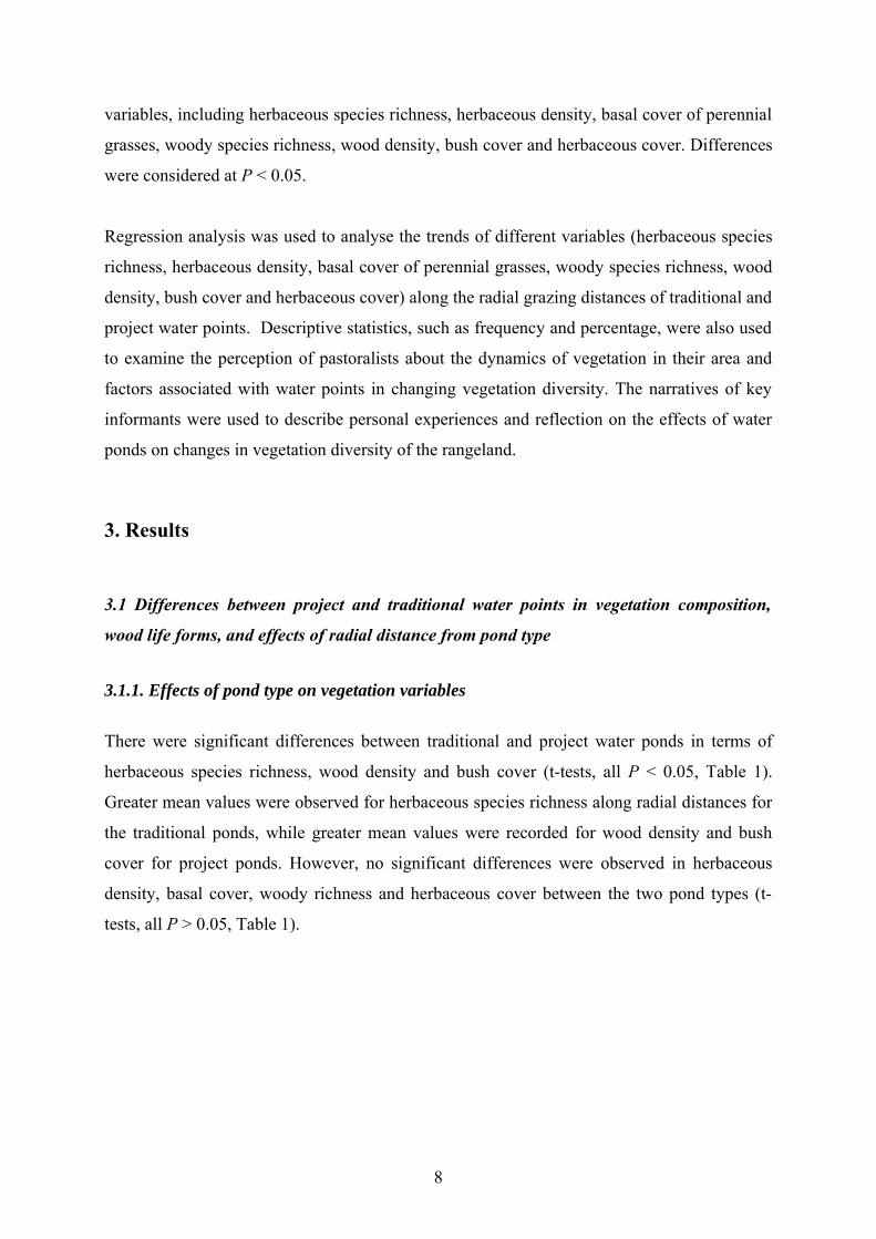
There were significant differences between traditional and project water ponds in terms of
herbaceous species richness, wood density and bush cover (t-tests, all P < 0.05, Table 1).
Greater mean values were observed for herbaceous species richness along radial distances for
the traditional ponds, while greater mean values were recorded for wood density and bush
cover for project ponds. However, no significant differences were observed in herbaceous
density, basal cover, woody richness and herbaceous cover between the two pond types (t-
tests, all P > 0.05, Table 1).
8
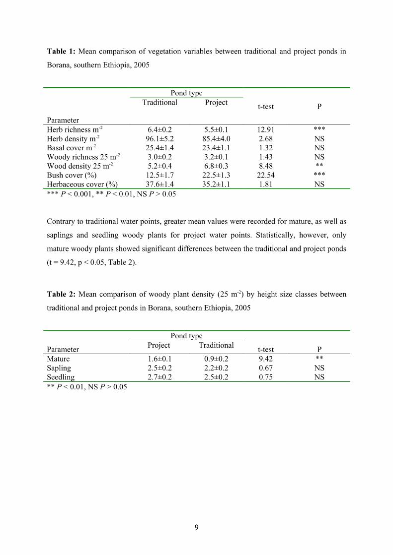
Table 1: Mean comparison of vegetation variables between traditional and project ponds in
Borana, southern Ethiopia, 2005
Parameter
Pond typeTraditional Project t-test P
Herb richness m-2 6.4±0.2 5.5±0.1 12.91 ***Herb density m-2 96.1±5.2 85.4±4.0 2.68 NSBasal cover m-2 25.4±1.4 23.4±1.1 1.32 NSWoody richness 25 m-2 3.0±0.2 3.2±0.1 1.43 NSWood density 25 m-2 5.2±0.4 6.8±0.3 8.48 **Bush cover (%) 12.5±1.7 22.5±1.3 22.54 ***Herbaceous cover (%) 37.6±1.4 35.2±1.1 1.81 NS*** P < 0.001, ** P < 0.01, NS P > 0.05
Contrary to traditional water points, greater mean values were recorded for mature, as well as
saplings and seedling woody plants for project water points. Statistically, however, only
mature woody plants showed significant differences between the traditional and project ponds
(t = 9.42, p < 0.05, Table 2).
Table 2: Mean comparison of woody plant density (25 m-2) by height size classes between
traditional and project ponds in Borana, southern Ethiopia, 2005
Parameter
Pond typeProject Traditional t-test P
Mature 1.6±0.1 0.9±0.2 9.42 **Sapling 2.5±0.2 2.2±0.2 0.67 NSSeedling 2.7±0.2 2.5±0.2 0.75 NS** P < 0.01, NS P > 0.05
9
3.1.2. Effects of radial distance from water points on vegetation variables
Herbaceous and tree species richness slightly increased along the radial grazing distance of traditional
water points as one moves towards the water points (Figure 1a and Figure 3a). With proximity to
project water points, herbaceous and tree species richness were reduced (Figure 2a and Figure 4a). The
trend portrayed by herbaceous density along the radial grazing distances from traditional and project
water points were comparable. In both cases, the trends showed a slight increase along the
radial grazing distance of the water points (Figure 1b and Figure 2b).
(b)
012345678
0 200 400 600 800 1000 1200
Her
ichn
ess
(a)
0
2
4
6
8
10
0 200 400 600 800 1000 1200
herb
. ric
hnes
s
(b)
0
50
100
150
200
0 200 400 600 800 1000 1200
Distance
herb
. den
sity
(b)
0
20
40
60
80
100
120
0 200 400 600 800 1000 1200
Dis tance (m )
Her
b. d
ensi
ty
10
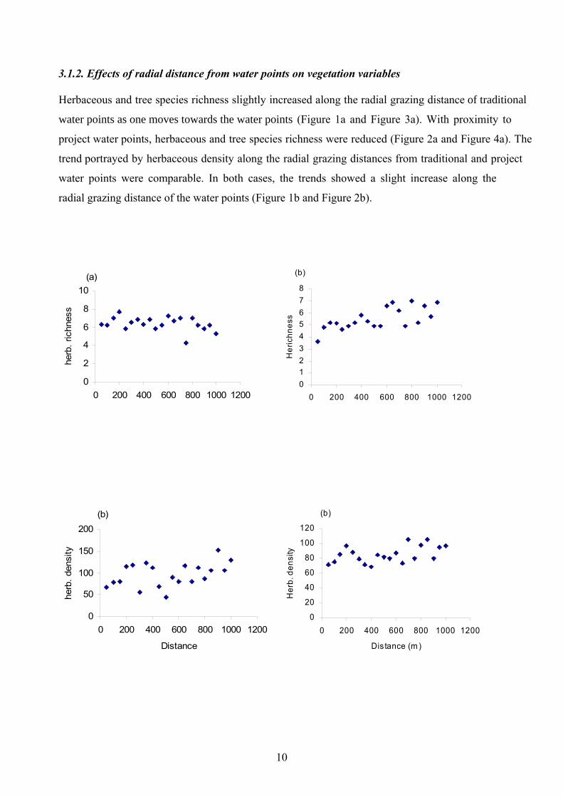
Figure 1: The trend of herbaceous richness, herb Figure 2: The trend of herbaceous richness, herb
density, basal cover and grass cover along radial density, basal cover and grass cover along radial
grazing distance of traditional water points grazing distance of project water points
(c)
0
10
20
30
40
50
0 200 400 600 800 1000 1200
Basa
l cov
er
(c)
05
10152025303540
0 200 400 600 800 1000 1200Ba
sal c
over
(%)
(d)
0
10
20
30
40
50
0 200 400 600 800 1000 1200
Distance (m)
Gra
ss c
over
(%)
(d)
0102030405060
0 200 400 600 800 1000 1200
Distance (m)
Gra
ss c
over
11
Basal and grass cover (Figure 2, c and d) showed a slight increase with proximity to project
water points, whereas with proximity to traditional water points, basal and grass cover showed a
slight decline (Figure 1, c and d), but away from the water points, the variables showed an
increasing trend beyond 500 m distance.
Bush cover showed a contrasting trend between radial grazing distance of traditional and
project water points. For traditional water points (Figure 3c), it showed very low cover at
distance near to the water points and a slight increase beyond 300 m. For the project water
points (Figure 4c), a high cover was observed near the water points and a slight decline was
exhibited after 500 m distance. Tree density showed a slight increase as one moves away from
the traditional water points, showing slight increases at 200 m, beyond which it showed a linear
trend up to the distance of 800 m and thereafter the changes depicted a sharp decline (Figure
3b). For the project water points, tree density portrayed an increasing trend all along the radial
grazing distance (Figure 4b).
12
Figure 3: Tree richness, tree density and bush Figure 4: Tree richness, tree density and bush
cover for traditional water points cover for project water points
(a)
012345
0 200 400 600 800 1000 1200
Distance (m)
Tree
rich
ness
(b)
010002000300040005000
0 200 400 600 800 1000 1200
Distance (m )
Tree
den
sity
(c)
05
10152025
0 200 400 600 800 1000 1200
Distance (m)
Bush
cov
er
(a)
012345
0 200 400 600 800 1000 1200
Distance (m)
Tree
rich
ness
(b)
010002000300040005000
0 200 400 600 800 1000 1200
Distance (m)
Tree
den
sity
(c)
0
10
20
30
40
0 200 400 600 800 1000 1200
Distance (m)
Bush
cov
er (%
)
13
Means for herbaceous and wood species richness increased with increasing distance from
project water points. Whereas the herbaceous species richness (t-test, P < 0.05) was
significantly varied, no significant differences were observed in wood species richness (t-test,
P > 0.05, Table 3). On the contrary, with increasing radial distance from traditional water
points, the means for herbaceous and woody species richness decreased, despite the changes
not being significant (t-test, all P > 0.05). Similarly, bush cover showed contrasting figures
with increasing radial distances between the project water points and the traditional ones. The
means increased with increasing distance from traditional water points, while it decreased
with increasing distance from project water points (t-test, P > 0.05).
Table 3: Mean comparison of traditional and project water ponds by effects of radial grazing
distance on vegetation variables in Borana, southern Ethiopia, 2005
Parameter
Traditional pond< 500 m > 500 m
t-test
Project pond< 500 m > 500 m
t-testHerbaceous richness m² 6.53 ± 0.24 6.18 ± 0.24 0.99 NS 4.94 ± 0.20 6.09 ± 0.20 15.82 **Herbaceous density m² 86.24 ± 8.18 105.90 ± 8.18 2.89 NS 80.38 ± 5.24 90.32 ± 5.24 1.80 NSBasal cover m² 22.18 ± 1.60 28.70 ± 1.60 8.57 ** 23.26 ± 1.68 23. 54 ± 1.68 0.01 NSWood richness 25 m² 3.05 ± 0.22 2.87 ± 0.22 0.34 NS 2.99 ± 0.19 3.43 ± 0.19 2.76 NSWood density 25 m² 5.15 ± 0.46 5.21 ± 0.46 0.01 NS 5.75 ± 0.54 7.85 ± 0.53 7.68 *Bush cover (%) 12.23 ± 1.79 12.70 ± 1.79 1.03 NS 23.53 ± 2.05 21.45 ± 2.05 0.51 NSHerbaceous cover (%) 35.00 ± 1.57 40.25 ± 1.57 5.58 * 34.38 ± 1.73 36.03 ± 1.73 0.45 NS
* P < 0.05, NS P > 0.05
Although herbaceous and wood density as well as basal and herbaceous cover showed
changes in greater mean values along the radial distances beyond 500 m for both water points,
only herbaceous and basal cover showed significant responses (t-test, all P < 0.05) to the
effects of radial distances from traditional water points, but failed to differ significantly in
response to radial distances from project water points. Furthermore, wood density did not
vary significantly by radial grazing distance from traditional water points, but it differed
significantly (t-test, P < 0.05) by the effects of radial distance from the project water points.
Herbaceous density (t-test, P > 0.05) failed to show significant responses to the effects of
radial distances from project or traditional water points.
3.2. Effects of distances from project and traditional water points on woody plants
The seedlings of woody plants showed significant increase with increasing radial distance
from project water points (t-test, P< 0.05), but were not significantly influenced by the effects
14
of radial distances from traditional water points, although greater mean value was recorded
within the 500 m distance along the 1 km transect (Table 4). Saplings displayed greater mean
values with increasing distances from traditional water points, but failed to disclose changes
along the radial grazing distances from the project water points. Although it was not
statistically significant, mean values for mature woody plants appeared to be high with
increasing distance (>500 m) as compared to the distances closer to the water points (<500
m).
Table 4: Mean differences of woody plant structure by effects of radial distance from project
and traditional water points in Borana, southern Ethiopia, 2005
Variables Traditional pond<500 m >500 m
t-test Project pond<500 m >500 m
t-test
Mature 0.67 ± 0.23 1.17 ± 0.23 2.41NS 1.47 ± 0.21 1.79 ± 0.22 1.10NSSapling 1.98 ± 0.27 2.48 ± 0.28 1.63NS 2.45 ± 0.24 2.45 ± 0.24 0.00NSSeedling 2.53 ± 0.30 2.37 ± 0.30 0.16NS 1.85 ± 0.27 3.56 ± 0.27 19.74*** * P < 0.05, NS P > 0.05
3.3. Vegetation species richness
Total plant species richness recorded within traditional (56) and project (58) water points
were comparable. The frequency of herbaceous species was 44.6% of the total species
sampled, while that of woody species comprised 55.4% for the traditional water points. For
project water ponds, herbaceous species richness accounted for 43%, whereas woody species
accounted for 57% of the total species. Sporobolus pyramidals was the dominant herbaceous
species for both pond types. Among herbaceous plant species, herbaceous legumes and other
herbs had a comparable frequency for both project and traditional water points. Entropogon
somalensis had greater frequencies along traditional water points, while Cynodon dactylon
was with larger frequency within project water points. Among woody plant species, Acacia
mellifera and Commiphora africana (both invasive species) were dominant along traditional
and project water ponds, respectively. Although Commiphora africana is the dominant
species for project ponds, it was also listed among species with greater frequency for
traditional water points in addition to Grewia tembensis and Grewia evolute. Acacia
drepanolobium and Ormocarpum trichocarum were among the most frequent woody species
within project water point areas (Table 5).
15

16
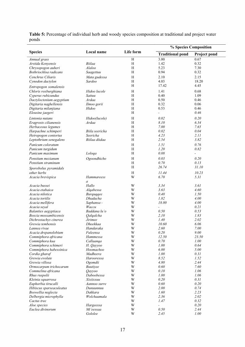
Table 5: Percentage of individual herb and woody species composition at traditional and project water ponds
Species Local name Life form
% Species Composition
Traditional pond Project pondAnnual grass H 3.00 0.67Arstida Kenyensis Biilaa H 1.42 0.32Chrysopogon auheri Alaloo H 5.23 7.30Bothriochloa radicans Saagettuu H 0.94 0.32Cenchrus Ciliaris Mata gudessa H 2.10 2.15Cynodon dactylon Sardoo H 4.03 18.20Entropogon somalensis H 17.42 4.45Chloris roxburghiana Hidoo lucole H 1.41 0.68Cyperus rubicundus Sattuu H 0.40 1.09Dactyloctenium aegyptium Ardaa H 0.50 0.46Digitaria naghellensis Ilmoo gorii H 0.32 0.06Digitaria milanjiana Hidoo H 0.53 0.46Eleusine jaegeri H - 0.46Lintonia nutans Hidoo(lucole) H 0.02 0.20Eragrosts cilianensis Ardaa H 8.10 6.34Herbaceous legumes H 7.00 7.65Harpachne schimperi Biila seericha H 0.02 0.04Hetropogon contortus Seericha H 4.23 2.11Leptothrium senegalens Biilaa diidaa H 2.54 3.82Panicum coloratum H 1.51 0.76Panicum turgidum H 1.20 0.82Panicum maximum Loloqa H 0.08 -Penstium mezianum Ogoondhicho H 0.03 0.20Penstium straminum H 0.70 0.13Sporobolus pyramidals H 26.74 31.10other herbs H 11.44 10.23Acacia brevispica Hammareess
aW 6.70 5.31
Acacia bussei Hallo W 3.34 3.61Acacia etabaica Alqabessa W 3.63 4.60Acacia nilotica Burquqqee W 0.40 1.50Acacia tortilis Dhadacha W 1.82 4.00Acacia mellifera Saphansa - W 18.00 4.00Acacia seyal Waccu W - 0.21Balanties aegyptiaca Baddana lu’o W 0.50 0.53Boscia mossambicensis Qalqalcha W 2.10 1.83Dichrostachys cinerea Jirimee W 1.40 2.02Grewia tembensis Dheekkaa W 10.60 6.06Lannea rivae Handaraka W 2.60 7.00Acacia drepanolobium Fuleensa W 0.20 9.00Commiphora africana Hammessa W 12.50 23.50Commiphora kua Callaanqa W 0.70 1.00Commiphora schimeri H. Qayyoo W 1.00 0.64Commiphora habessinica Hoomachoo W 6.00 5.00Cordia gharaf Madheera W 1.00 0.31Grewia evolute Harooressa W 8.52 1.52Grewia villosa Ogomdii W 4.80 2.44Ormocarpum trichocarum Buutiyee W 0.60 7.60Commelina africana Qayyoo W 0.10 1.06Rhus ruspolii Daboobessa W 1.00 1.06Kleinia squarrosa Xixiixxuu W 0.20 0.31Euphorbia tirucalli Aannoo surre W 0.60 0.20Hibiscus sparseaculeatus Dunuunnuu W 2.00 0.74Boswellia neglecta Dakkara W 1.60 2.23Delbergia microphylla Wolchaamala W 2.36 2.02Cactus tree W 1.47 0.32Aloe species Hargeessa W - 0.20Euclea divinorum Mi’eessaa W 0.50 2.44
Gololee W 2.45 1.00
17
Fursa W 1.82 0.32
3.4. Pastoralists’ perceptions of changes in vegetation diversity and contributing factors
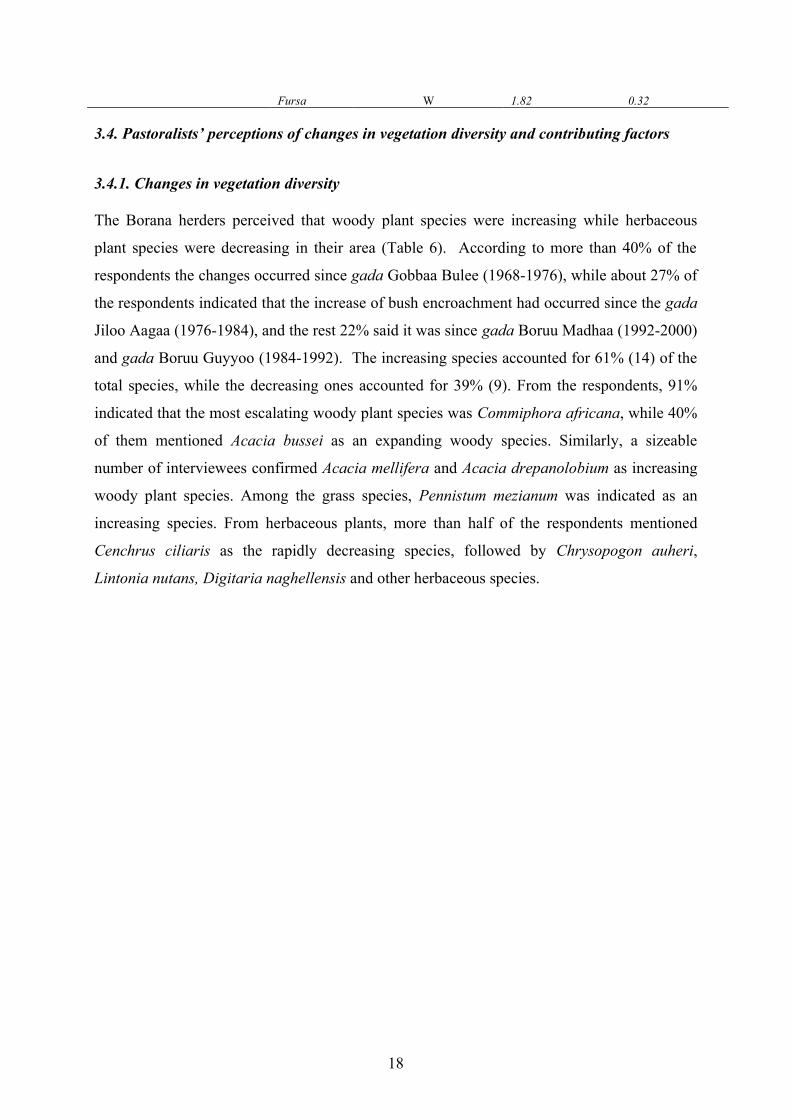
3.4.1. Changes in vegetation diversity
The Borana herders perceived that woody plant species were increasing while herbaceous
plant species were decreasing in their area (Table 6). According to more than 40% of the
respondents the changes occurred since gada Gobbaa Bulee (1968-1976), while about 27% of
the respondents indicated that the increase of bush encroachment had occurred since the gada
Jiloo Aagaa (1976-1984), and the rest 22% said it was since gada Boruu Madhaa (1992-2000)
and gada Boruu Guyyoo (1984-1992). The increasing species accounted for 61% (14) of the
total species, while the decreasing ones accounted for 39% (9). From the respondents, 91%
indicated that the most escalating woody plant species was Commiphora africana, while 40%
of them mentioned Acacia bussei as an expanding woody species. Similarly, a sizeable
number of interviewees confirmed Acacia mellifera and Acacia drepanolobium as increasing
woody plant species. Among the grass species, Pennistum mezianum was indicated as an
increasing species. From herbaceous plants, more than half of the respondents mentioned
Cenchrus ciliaris as the rapidly decreasing species, followed by Chrysopogon auheri,
Lintonia nutans, Digitaria naghellensis and other herbaceous species.
18
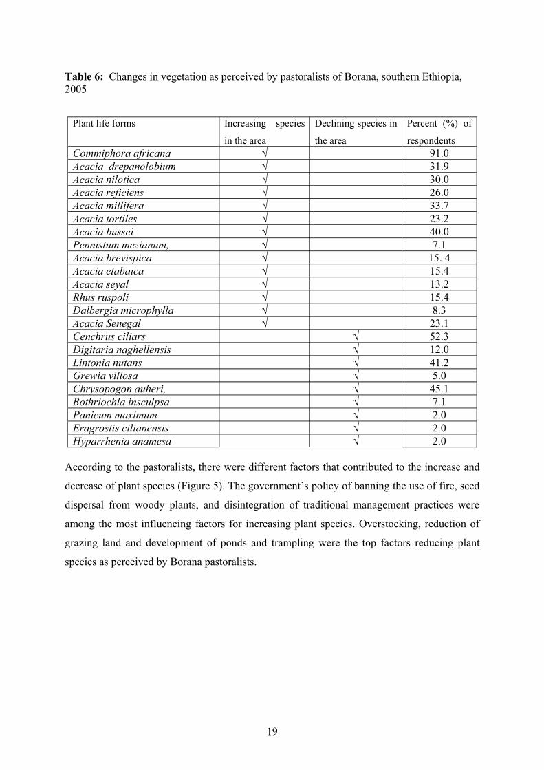
Table 6: Changes in vegetation as perceived by pastoralists of Borana, southern Ethiopia, 2005
According to the pastoralists, there were different factors that contributed to the increase and
decrease of plant species (Figure 5). The government’s policy of banning the use of fire, seed
dispersal from woody plants, and disintegration of traditional management practices were
among the most influencing factors for increasing plant species. Overstocking, reduction of
grazing land and development of ponds and trampling were the top factors reducing plant
species as perceived by Borana pastoralists.
Plant life forms Increasing species
in the area
Declining species in
the area
Percent (%) of
respondentsCommiphora africana √ 91.0Acacia drepanolobium √ 31.9Acacia nilotica √ 30.0Acacia reficiens √ 26.0Acacia millifera √ 33.7Acacia tortiles √ 23.2Acacia bussei √ 40.0Pennistum mezianum, √ 7.1Acacia brevispica √ 15. 4Acacia etabaica √ 15.4Acacia seyal √ 13.2Rhus ruspoli √ 15.4Dalbergia microphylla √ 8.3Acacia Senegal √ 23.1Cenchrus ciliars √ 52.3Digitaria naghellensis √ 12.0Lintonia nutans √ 41.2Grewia villosa √ 5.0Chrysopogon auheri, √ 45.1Bothriochla insculpsa √ 7.1Panicum maximum √ 2.0Eragrostis cilianensis √ 2.0Hyparrhenia anamesa √ 2.0
19
0
10
20
30
40
50
60
incr
ease
decr
ease
incr
ease
decr
ease
incr
ease
decr
ease
incr
ease
decr
ease
incr
ease
decr
ease
incr
ease
decr
ease
incr
ease
decr
ease
incr
ease
decr
ease
incr
ease
decr
ease
incr
ease
decr
ease
Settlement Overgrazing Trampling Lack ofmobility
Developmentof ponds
Ban on fire Spreadingof seed
Disintegrationof traditional
practices
Overstocking Reductionof grazing
land
Contributing factors
Perc
ent o
f res
pond
ents
(%)
Figure 5: Respondents’ perceptions of different factors contributing to vegetation change in
Borana, southern Ethiopa, 2005
Considering water ponds as contributing factors for vegetation dynamics, respondents were
asked the species that have been increasing and decreasing in the area, and their responses
were summarized (Table 7). While woody plant species were increasing, herbaceous plant
species were decreasing due to ponds. Commiphora Africana, Tussee2 and Acacia
drepanolobium were species perceived to be highly increasing among the woody plant
species. Cenchrus ciliars, Chrysopogon auheri and grasses in general were perceived to be
highly decreasing among the herbaceous plant species.
2 We could not find a scientific name for Tussee. It is the local name used to refer to shrubs, but some researchers use it to refer to encroaching bushes.
20

Table 7: Increasing and decreasing species due to ponds as perceived by pastoralists,
southern Ethiopia, 2005
While Table 7 depicts the effects of ponds in general, the relative contribution of project and
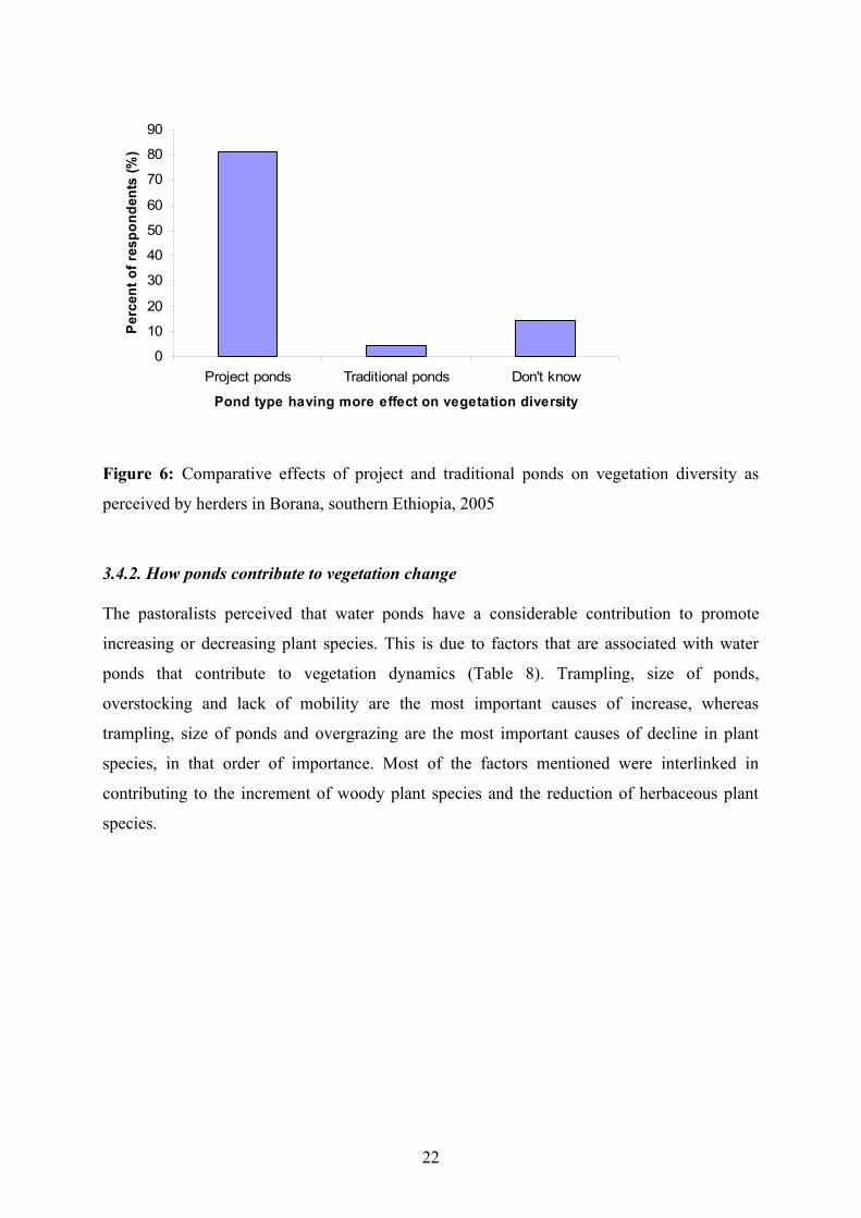
traditional ponds, as perceived by respondents, is shown below (Figure 6). Project ponds,
according to the herders, contributed twenty times as much as traditional ponds to the
increasing of woody plant species and the decreasing of herbaceous plant species.
Species Increasing species
due to ponds
Decreasing species
due to ponds
Percent (%) of
respondents Commiphora africana √ 49.1Acacia drepanolobium √ 26.3Acacia nilotica √ 18.2Acacia bussei √ 18.2Acacia brevispica √ 7.3Acacia etabaica √ 5.5Tussee √ 30.1Cenchrus ciliars √ 66.0Digitaria naghellensis √ 9.1Chrysopogon auheri √ 63.8Digitaria milanjiana √ 49.0Hetropogon contortos √ 10.6Arstida kenyensis √ 4.3Dactyloctenium aegyptium √ 7.0Grasses in general √ 68.1
21
0
10
20
30
40
50
60
70
80
90
Project ponds Traditional ponds Don't know
Pond type having more effect on vegetation diversity
Perc
ent o
f res
pond
ents
(%)
Figure 6: Comparative effects of project and traditional ponds on vegetation diversity as
perceived by herders in Borana, southern Ethiopia, 2005
3.4.2. How ponds contribute to vegetation change
The pastoralists perceived that water ponds have a considerable contribution to promote
increasing or decreasing plant species. This is due to factors that are associated with water
ponds that contribute to vegetation dynamics (Table 8). Trampling, size of ponds,
overstocking and lack of mobility are the most important causes of increase, whereas
trampling, size of ponds and overgrazing are the most important causes of decline in plant
species, in that order of importance. Most of the factors mentioned were interlinked in
contributing to the increment of woody plant species and the reduction of herbaceous plant
species.
22
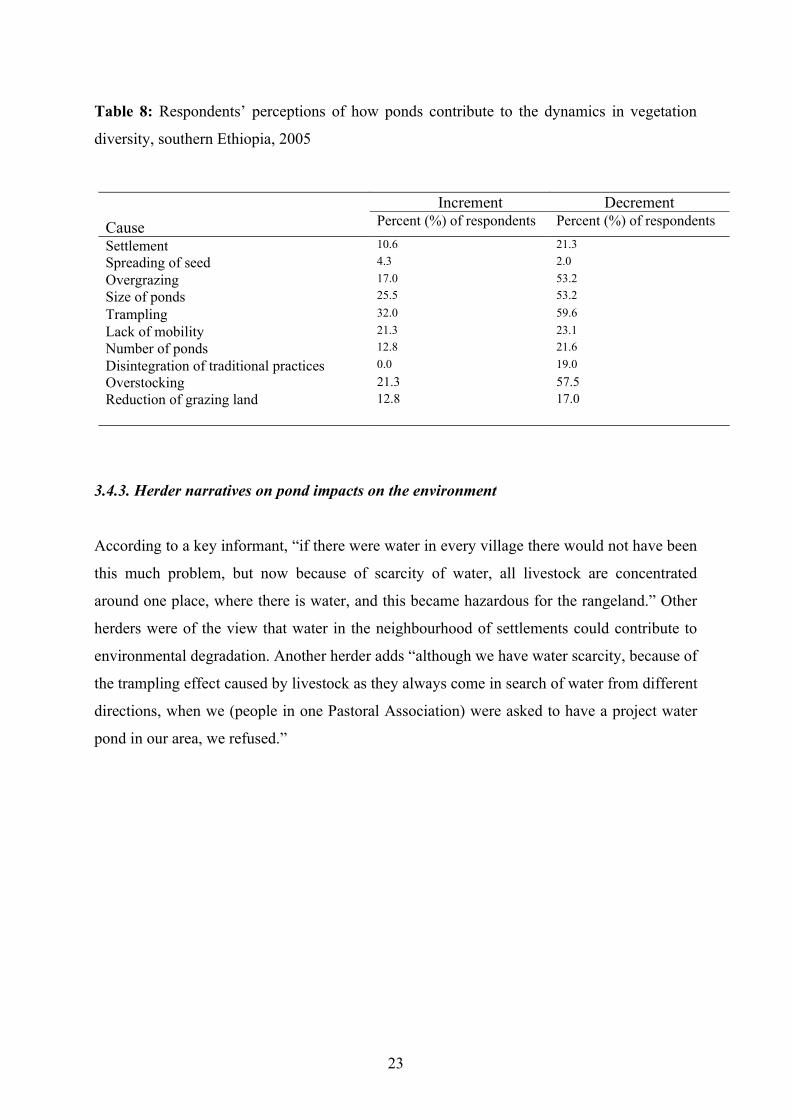
Table 8: Respondents’ perceptions of how ponds contribute to the dynamics in vegetation
diversity, southern Ethiopia, 2005
CauseIncrement Decrement
Percent (%) of respondents Percent (%) of respondents
Settlement 10.6 21.3Spreading of seed 4.3 2.0
Overgrazing 17.0 53.2Size of ponds 25.5 53.2
Trampling 32.0 59.6
Lack of mobility 21.3 23.1Number of ponds 12.8 21.6
Disintegration of traditional practices 0.0 19.0Overstocking 21.3 57.5Reduction of grazing land 12.8 17.0
3.4.3. Herder narratives on pond impacts on the environment
According to a key informant, “if there were water in every village there would not have been
this much problem, but now because of scarcity of water, all livestock are concentrated
around one place, where there is water, and this became hazardous for the rangeland.” Other
herders were of the view that water in the neighbourhood of settlements could contribute to
environmental degradation. Another herder adds “although we have water scarcity, because of
the trampling effect caused by livestock as they always come in search of water from different
directions, when we (people in one Pastoral Association) were asked to have a project water
pond in our area, we refused.”
23
4. Discussion
4.1. Differences between project and traditional water points, in terms of vegetation
composition, wood life forms and effects of radial distance from pond type.
4.1.1. Effects of pond type on vegetation variables
The significant difference observed in herbaceous species richness, wood density and bush
cover between traditional and project water points probably reflected the effects of
management between the two pond types. Traditional water points were smaller watering not
more than 2000 livestock per, while the project ponds could serve up to 15,000 livestock per
day. Besides, the rules and regulations of use being stricter for traditional ponds than for
project ones, the project water ponds tends to be open for all, whereas the traditional water
ponds are under the control of clans. The management difference therefore seemed to have
implications for conservation and loss of biodiversity. Around the different types of ponds,
the extents of degradation were probably related to the numbers of livestock watered daily
and the presence or absence of regulations of stocking density (Todd, 2006).
Although there was no difference observed between the two pond types in herbaceous
density, woody richness, basal cover and herbaceous cover, greater mean values were
recorded for traditional water points with the exception of woody richness. This implies that
traditional water ponds were in better range condition than project water ponds.
Although only mature woody plants differed significantly between pond types, the recorded
greater mean values for mature, sapling and seedling woody plants along the radial grazing
distance of project water points implies that project water points had more contribution to
bush encroachment than traditional ones. Increases in woody vegetation have been commonly
reported as a response to heavy grazing pressure (Coppock, 1994).
24
4.1.2. Effects of distance from project and traditional water points on vegetation variables
There were contrasting trends between herbaceous species richness and bush cover along the
radial grazing distances from project water points. The decrements of herbaceous species
richness in the vicinity of project water points perhaps resulted from heavy concentrations of
livestock causing overgrazing and trampling that affects more of palatable and sensitive
species, while allowing the growth of less sensitive and non-palatable plant species. This is
similar to what has been reported for wildlife (Thrash, 2000).
My results confirm what has been reported by Todd (2006) that “areas close to watering
points tend to be over utilized and associated with a reduction in plant species richness.” My
research also confirmed the evidence reported earlier that impacts on plant species was less
far away from the water points where the pressure of grazing was less (Nangula and Oba,
2004; Oba, et al., 2001). The effect of grazing pressure on species richness would be more
pronounced in areas with a short grazing history (Oba, et al., 2001). This has an important
implication given the lifetime difference between project and traditional water points, the
former being a much more recent phenomenon. The selectiveness of livestock (Squires, 1981)
for more palatable species will not let plant species withstand high grazing pressure near more
permanent water points than the temporary water sources (for boreholes see Moleele, 1994).
Changes in herbaceous species richness could also be the effect of bush encroachment
(Coppock, 1994).
The increase in bush cover with proximity to project water points suggests that the growing
effect of grazing pressure next to the water points could promote expansion of woody plant
species at the expenses of herbaceous plant species. This study supports the finding of Archer
(1990), who stated that “increases in woody plant abundance are normally accompanied by
decreases in herbaceous production and undesirable shifts in composition.” The selective
grazing of livestock probably increases the abundance of shrub species at the expense of more
palatable and less grazing tolerant species (Milchunas, et al., 1988). Moleele and Perkins
(1998) also showed that areas next to the boreholes are extremely susceptible to invasion by
encroaching woody plant species.
Unlike project water points, herbaceous species richness slightly increased while bush cover
decreased as we move towards traditional water points. The increasing trend in herbaceous
25
species richness is probably related to the fact that traditional ponds served only a limited
number of animals and for short period of time. This avoids the concentration of a large
number of livestock in one pasture area for long period of time, in effect saving palatable and
grazing intolerant plant species from further destruction. It is also because of reduced grazing
pressure from livestock and human disturbance that gives herbaceous plant species equal
chance of growing around the water point, allowing all to coexist. While management of the
traditional water points has a positive contribution for herbaceous species richness, it
discouraged the expansion of bush cover by maintaining the competitive ability of herbaceous
vegetation over the bush plants.
The increase of bush cover with increasing radial distance from traditional water point could
not be explained in terms of grazing pressure alone. It was probably more attributed to other
factors like topography, soil types and the fact that the bushes are not burned for long period
of time due to policy ban on fire. For example, Haroo Jaaroo, which is located in Dubuluq
attracted our attention for the potential contribution of topography as it exhibited a steep slope
and more degraded environment as compared to other traditional ponds. Changes in bush
cover may be due to external and internal factors that shifted patterns of land use (Oba, et al.,
2000). Abundance of herbaceous species showed similar trends along the radial grazing
distances for both traditional and project water points. But this should not be mistaken to
imply that the herbaceous condition is comparable for both pond types.
The increasing trends observed for basal and grass cover with proximity to project water
points were likely to be related to contrasting responses by different species, i.e., when
trampling and overgrazing negatively affect palatable and sensitive species, grazing tolerant
and non palatable species flourished at the expense of palatable and sensitive ones. The
consequence is increases in total species pool, suggesting that species richness is not a good
indicator of land degradation (see also Oba et al., 2003). Therefore, the figure gives false
impression that the vegetation condition in terms of grass and basal cover around the water
point was good. Todd (2006) suggested that the impact of grazing pressure is more
pronounced on plant species richness than plant cover. The location of some project water
points and the season in which data was collected might also had contribution to the trends of
basal and grass cover around water points. The time during which the data were collected was
after the long rainy season and that might have contributed to good vegetation condition. In
terms of locality, some ponds, especially Haroo Bakkee, which is located in Yaaballo and
26
Haroo Bokossaa, located in Dubulluq, were situated in a slightly valley area with the
tendency to accumulate runoff water and top soils that have been washed from upper lands. It
seems that the project ponds were intentionally located in such areas. This potentially
facilitates soil erosion, which apparently contributes to rangeland degradation.
4.1.3. Effects of distance from project and traditional water points on mature, sapling and
seedling plants
Herbivore trampling around watering points negatively affects the survival of seedlings of
woody plants (Brits, et al, 2002). The results of this study also indicate that the trampling
effects around project water points probably restricted the chance of woody seedlings to
establish. In effect, the reduced number of seedlings could also have an impact in reducing the
number of saplings and mature woody plants around the water points. The increased number
of seedlings and mature woody plants at distances greater than 500 m would be the result of
less trampling. Whereas the absence of difference in sapling woody plants between distances
less and greater than 500 m can be due to livestock browsing, at distances greater than 500 m,
where the impacts were less, tree saplings were more established.
The larger number of seedlings observed around traditional water points could be due to less
trampling that increased the survival of the seeds of mature woody plants. However, the mean
values for mature woody plants were larger along project water points than traditional ones.
The larger number of sapling and mature woody plants observed at distances beyond 500 m
for traditional water points could not be explained by management alone, but also could be
due to environmental factors such as topography and soil types as well as the overall effects
of the ban of fire and expansion of bush encroachment.
4.2. Vegetation species richness
Along the radial distances from the project and traditional water points, there were
comparable types of vegetation composition. This was probably because water ponds
developed in geographical proximity (the same geographical area) have the possibility to be
comparable in vegetation composition although the frequency of occurrence varied. The
larger frequency of Sporobolus pyramidals along both project and traditional water points,
suggests that the species was tolerant to grazing pressure. The comparable frequency of
27
herbaceous legumes and other herbs within project and traditional water points indicate that
management had no influence on it. The forbs were promoted by heavy trampling in the
piospheres around water points of both pond types.
The dominance of Commiphora africana and the greater frequency of Acacia drepanolobium
as well as Ormocarpum trichocarum along project water point suggest that the areas around
project water points were under the invasion of encroaching woody plants. Oba (1998)
indicates that Acacia drepanolobium and Commiphora african are among species accounted
for bush encroachment and their population structure illustrates cycles of invasion. Acacia
millifera, a dominant woody species, and Commiphora Africana, with higher frequency along
traditional water points, are encroaching woody plant species. By comparison, although
Grewia tembensis and Grewia evolute had higher frequencies along the water points, they
were valuable woody plant species for livestock and human use Coppock, 1994). The
availability of valuable woody plants with higher frequency along traditional water points
indicates that the area comprising traditional water ponds are more favourable for livestock.
4.3. Pastoralists’ perceptions of changes in vegetation diversity and contributing factors
4.3.1. Changes in vegetation diversity
The time reported by respondents about the occurrence of vegetation diversity changes in
Borana corresponds with the beginning of development intervention in the area in the 1980s.
The end of gada Gobbaa Bulee (1968-1976), which marked the decline of herbaceous plant
species according to more than 40% of the respondents, is associated with the start of the
Third Livestock Development Project, from 1976-1986 (Coppock, 1994). Water development
was one of the components of the project. The suggestion was that there was a probable link
between project water points and deterioration of range condition as perceived by the
pastoralists. Other development components of the project, including veterinary service,
forage development, road development and ranching might have increased livestock
population, encouraged settlement and reduced mobility, increasing the number of livestock
around water points. This could have contributed to range degradation in the view of the
Borana herders.
28
According to the respondents, Commiphora Africana, Acacia bussei, Acacia mellifera and
Acacia drepanolobium were among the top species that showed increasing trends in the area.
This was confirmed by the vegetation sampling around the different pond types. The
exception was Acacia bussei, for which we had lower frequency. The species predominates
high uplands where the ponds were not represented. Perhaps, the herders were referring to the
larger grazing lands where the species is considered to have encroached (Gemedo Dalle,
2005). The decreasing herbaceous plant species mentioned by respondents also occurred in
low frequencies. This indicates that the perception of respondents and the empirical field data
all confirmed and decreasing herbaceous layer and the increasing woody cover in the pond-
water rangelands. There was a clear link between the decline of the herbaceous vegetation,
increase in bush cover and rangeland degradation even from the perspectives of the Borana
herders.
4.3.2. Factors contributing to changes in vegetation diversity
There were different factors that contributed to increasing or decreasing plant species in the
pond water rangelands in Borana. According to the herders interviewed, fire banning had
contributed to the expansion of wood plant species. According to the herders, seed scattering
by livestock facilitated bush expansion (cf. Tamene Yigezu, 1990). The Boran who were
cattle keepers blamed the increasing use of the area by camels that as browsers were said to
have contributed to seed dispersal of the invasive species. The herders were of the view that
when the herbaceous vegetation was reduced, they offered less competition with the woody
species and, therefore, the seeds of woody plant species were easily established (see also Oba,
1998). Thus, fire banning shifted the balance between tree and grass layers, increasing the
competitive advantage of trees over grasses (Coppock, 1994). The interviewees repeatedly
mentioned that places that earlier had no wood vegetation before the development of the
ponds were invaded by woody plant species.
4.3.3. Increasing and decreasing species due to development of water ponds
The Borana explained the contribution of water ponds in increasing woody and decreasing
herbaceous plant species more in relation to project water ponds. They have highlighted that
project ponds are more influencing than traditional water ponds in terms of vegetation
dynamics. They explained how development of ponds contributed to the increment of woody
29
and decrement of herbaceous plant species in the area in association with different factors,
most of which are interlinked. They perceived that the settlement policy, which was initiated
by the Derg3, was the cause for water development. The developed water sources have larger
capacity than the water sources they traditionally have had–traditional ponds. Because of its
larger capacity, the project ponds support large number of livestock. Due to this, the areas
around water points are highly trampled and overgrazed. In places where there is large
quantity of ponds, grasses are overgrazed while tree cover is expanding. In areas where the
number and the size of ponds were increasing, pastureland was decreasing and overstocking
was becoming a serious problem.
Moreover, the restriction of movement that comes in relation to settlement policy forced
herders to give up traditional mobility between wet and dry season pasture. In the past, during
the wet season, livestock used to drink from hand-dug or traditional ponds. Since the water is
small in volume, it did not sustain livestock throughout the season, so they moved to other
pasture area leaving the place fallow for one year, and during the dry season they returned to
the wells. However, with the development of project ponds, which are open-access resources,
traditional practices disintegrated. This enhanced a year-round land use that resulted in
overgrazing of the grass cover. The heavy use has left a serious impact on range and the
environmental conditions.
Because of the concentrations of livestock in smaller areas, the palatable grass species, such
as Cenchrus ciliars, Chryspogon auheri and grasses in general, have been over-utilized, as the
pastoralists have pointed out. Apart from describing the prevailing situation as extremely
undesirable, herders emphasized their worries about the future.
The narratives of the respondents emphasized the concerns and different interpretations of the
community about the environmental problems associated with the project water ponds. At
first glance, the two seem to be contradicting. While some herders suggested that having more
water sources in different villages could reduce the decline of herbaceous plant species, the
others were of the view that the development of water in their area increased the decline of
herbaceous plant species in that area.
3 Derg refers to the former Ethiopian regime that was on power from 1974-1991.
30
According to the latter group, although the scarcity of water was a problem in their area, their
refusal of water-pond development emphasized the links between degradation of range with
water ponds. Similarly, the idea suggested by the first group indicated that, as far as there was
lack of sufficient water in every village, there would be a concentration of livestock around
available water ponds. The poor distribution of livestock would ultimately result in loss of
herbaceous plant species. Both respondents are thus concerned about trampling and
overgrazing caused by livestock, as they are concentrated around water points, consequently
leading to rangeland degradation.
As the pastoralists have perceived, Commiphora Africana, Tussee and Acacia drepanolobium
were increasing woody plant species, whereas, Cenchrus ciliars, Chrysopogon auheri and
grasses in general were among decreasing herbaceous plants species due to development of
ponds. This indicates that the decreasing species perceived to result from the development of
water ponds were more adversely affected by the trampling effect and overgrazing, which was
more pronounced around the water points. The encroaching woody plant species and their
dominance had an effect of increasing unpalatable species over the palatable ones.
5. Conclusion
The rangelands of Borana, southern Ethiopia, are undergoing serious challenges, one of which
could be associated with the recent water development interventions. Our findings support the
hypothesis that rangeland degradation is more evident with project water points than the
traditional ones. There were significant difference between project and traditional water ponds
in relation to herbaceous species richness; wood density and bush cover, suggesting
management difference has a contribution in changing vegetation diversity. Even though there
were no significant differences observed between the two pond types in herbaceous density,
woody richness, basal cover and herbaceous cover, greater mean values were recorded for
traditional water points with the exception of woody richness. The implication was that
traditional water ponds were in better range condition than project water ponds.
There were contrasting trends between project and traditional water points with respect to
herbaceous species richness and bush cover. Herbaceous species richness showed increasing
trend with proximity to traditional water points, while it showed decreasing trend with
31
proximity to project water points. Contrary to this, bush cover increased towards project water
points, while it decreased towards traditional water points. The reduction of herbaceous plant
species and the increment of bush cover in the vicinity of project water points indicate that the
trampling and overgrazing marked around the water point are much more serious in terms of
biodiversity loss. The opposite trend observed for traditional water ponds has important
implications for conservation of the rangelands. This suggests that traditional water
management has a positive contribution for herbaceous species richness, which has
implications for management of biodiversity. While the traditional water management
discourages the growth of non-palatable and the expansion of woody plant species, project
water ponds negatively affect more of palatable and sensitive species, allowing the growth of
non-palatable and promote expansion of woody plant species.
The increasing trend of basal cover and grass cover with proximity to project water points was
related to the contrasting responses by different species that increased total species pool, and
may be due to the location of some water sources and the timing of data collection.
Although only mature woody plants have marked significant difference between the two pond
types, sapling and seedling woody plants showed greater mean values for project water points
than traditional ones, suggesting that wood encroachment is more pronounced around project
water points than traditional ones. Seedling woody plants showed significant increase with
increasing radial grazing distance from project water points, but there was no significant
difference for traditional water points although greater mean values were observed within the
distance less than 500 m than the distance away from the water points (>500 m). This implies
that trampling is more pronounced around project water points than traditional water points,
in effect reducing the establishment of seedling woody plants around the former.
There are comparable types of species composition along project and traditional ponds.
Sporobolus pyramidals was the dominant herbaceous species for both pond types.
Encroaching woody plants with larger frequency were more marked along project water
points than traditional ones, whereas traditional water points encompass also valuable woody
plant species with larger frequency.
The prevailing perceptions of Borana pastoralists confirm that there is a considerable change
in vegetation diversity in the area, most markedly during the last few decades. As perceived
32
by the pastoralists, woody plant species were increasing while herbaceous plant species were
decreasing. This corresponds with the empirical evidence obtained through scientific
methods, suggesting the need for collaborative approach in range management and
biodiversity conservation.
The perceived factors that contributed to the vegetation dynamics of the area include ban on
fire, spreading of seeds, overstocking, overgrazing, development of water ponds, reduction of
grazing land, trampling, settlement and the disintegration of traditional management practices.
These factors are not mutually exclusive; most of them are interlinked. For instance, the
development of water ponds is associated with settlement, trampling, overstocking and
overgrazing, ultimately contributing to the increment of woody plant species and the
reduction of herbaceous plant species. The relative contribution of project water ponds in
degrading the rangelands was perceived to be far higher than that of traditional ones.
In general, differences in management of project and traditional water points have
implications for vegetation diversity and range condition. As opposed to project water ponds,
we observed better herbaceous condition and less expansion of woody plant species for
traditional project ponds. The elaborate water management of the society must, therefore,
have enormous contribution in sustaining the rangelands. The observance of water-source
capacity in deciding extent of use is a vital management strategy as it limits livestock and
human population that may be supported by the surrounding rangelands. The established
tradition of coping with water shortage and enumerating rules and regulations for access to
water also avoid free ride. These contribute to maintaining better range condition. That is
why, in Borana, water is considered not just as a resource but also a tool for range
management (Oba, 1998).
33
Reference
Blench, R. and Marriage, Z. (1999). Drought and Livestock in Semi-arid Africa and Southwest Asia. Overseas Development Institute, London.
Brits, J., van Rooyen, M. W. and van Rooyen, N. (2002). Ecological impact of large herbivores on the woody vegetation at selected watering points on the eastern basaltic soils in the Kruger National Park. African Journal of Ecology, 40: 53-60.
Coppock, D. L. (1994). The Borana Plateau of Southern Ethiopia: Synthesis of Pastoral Research, Development and Change. ILCA, Addis Ababa, Ethiopia.
Desta, S. and Coppock, L. (2000). Pastoral system trends and small ruminant production in the
Borana plateau of southern Ethiopia. Agricultural Research and Extension Programs. Langston University, USA.
Florian, J. Suzanne., M. J.; Richard, D.W.; Noel, V. R. (1997). "Simulated pattern from around artificial waterholes in the semi-arid Kalahari ." Journal of arid environments, 8: 177-188.
Gemedo Dalle, Maass, B. L. and Isselstein, J. (2005). Plant communities and their species diversity in the semi-arid rangelands of Borana lowlands, southern Oromia, Ethiopia. Community Ecol., 6: 167-176.
Helland, J. (1980). Pastoralists and the Development of Pastoralism. African Savannah Studies. University of Bergen, Bergen.
Helland, J. (1982). Social organization and water control among the Borana . Development and change, 13: 239-258.
Helland, J. (2002). Land Allination in Borana: some Land Tenure Issues in A Pastoral Context in Ethiopia. In: Babiker, M. (Ed.), Resource Alination Militarisation and Deveolpment. Case studies from East Africa Drylands. Addis Abeba, Ethiopia. Organization for social Science Research in Eastern and South Africa. Addis Ababa: 47-65.
Landsberg, J., James, C. D., Morton, R.S., Muller, J.W. and Stol, J. (2003). Abundance and Composition of plant species along grazing gradients in Australian rangelands. Journal of applied Ecology, 40: 1008-1024.
Legesse, A. (1973). Gada: Three Approaches to the Study of African Society. The Free Press, New York.
Milchunas, D. G., Sala, O. E. and Lauenroth, W. K. (1988). A generalized model of the effects of grazing by large herbivores on grassland community structure. American Naturalist 132: 87-106.
Moleele, N. M. (1994). Ecological change and piosheres: can the classical range succession model and its modifications explain changes in vegetation and soil around boreholes in south eastern Botswana? MSc thesis, University of Canberra, Australia.
Moleele, M. N. and Perkins S. J. (1998). Encroaching woody plant species and boreholes: is cattle density the main driving factor in the Ollfants Drift communal grazing lands, south –eastern Botswana? Journal of Arid Environments, 40: 245-253.
Nangula, S. and G. Oba (2004). Effects of artificial water points on the Oshana Eosystem in Namibia. Environmental conservations, 31: 1-8.
34
Oba, G. (1998). Assessment of Indigenous Range Management Knowledge of the Booran Pastoralists of Southern Ethiopia (Part I). Report to Boorana Lowlands Pastoral Development Program, BLPDP/GTZ, Negelle Boorana.
Oba, G. and Kaitira, L. M. (2006). Herder knowledge of landscape assessments in arid rangelands in northern Tanzania, Journal of Arid Environment, 66: 168-186.
Oba, G., Stenseth, N. C. and Lusigi, W. J. (2000). New Perspective on sustainable grazing management in arid zones of Sub-sharan Africa. BioScience, 50 (1): 35-51.
Oba, G., Kotile, D. G. (2001) Assessments of landscape level degradation in southern Ethiopia: pastoralists vs ecologists. A Paper Prepared for the International Conference on Policy and Institutional Options for the Management of Rangelands in dry Areas. Hammamet, Tunisia.
Oba, G., Post E., Syvertsen and Stenseth N.C. (2000). Bush cover and range condition assessments in relation to landscape and grazing in southern Ethiopia. Landscape ecology, 15: 535-546.
Oba, G., Vetaas, O. R. and Stenseth N. C. (2001). Relationships between biomass and plant species richness in arid-zone grazing lands. Journal of applied Ecology, 38: 836-845.
O’Connor, T. G. (1994). Composition and population responses of an African savanna to rainfall and grazing. Journal of Applied Ecology, 31: 155-171.
Owen-Smith, N. (1996). Ecological guidelines for water points in extensively protected areas. South African Journal of Wildlife Research, 26: 107-112.
Parker, A. H. W., T. F. (1999). Long term impacts of abundant perennial water provision for game on herbaceous vegetation in a semi-arid African Savanna woodland. Journal of Arid Environments, 41: 309-321.
Sandford, S. (1983). Management of Pastoral Development in Third World. Wiley, Chichester and Overseas Development Institute, London.
Skarpe, C. (1986). Plant community structure in relation to grazing and environmental changes along a north-south transect in the western Kalahari. Vegetatio, 68: 3-18.
SOS Sahel. (2002). Moving with the Times: Challenges Facing Pastoralism and Pastoralists in Ethiopia. SOS Sahel International UK.
Squires, V. (1981). Livestock management in the arid zone. Inkata Press, Sydney.Thrash, I. (2000). Determinants of the extent of indigenous large herbivores impact on
herbaceous vegetation at watering points in the north-eastern lowveld, South Africa. Journal of Arid Environments, 44:61-72.
Thrash, I., NEL, P. J., Theron K. G. and Bothma J.DU P. (1991). The impact of the provision of water for game on the basal cover of the herbaceous vegetation around a dam in the Kruger National Park. Koedoe, 34: 121-130.
Thrash, I.P., Theron, K. G. and Bothma J. P. (1993). Impact of water provision on herbaceous community composition in the Kruger National Park, South Africa. Afr J Range For Sci, 10: 31-35.
Todd, W. S., (2006). Gradients in vegetation cover, structure and species richness of Nama- Karoo shrublands in relation to distance from livestock watering points. Journal of Applied Ecology, 43: 293-304.
Walker, B. H. (1987). A general model of savanna structure and function. In: Walker, B. H. (Ed.), Determinants of Tropical Savannas. IUBS Monograph Series, 3: 1-12.
Watson, E. (2003). Examining the potential of indigenous institutions for development: A perspective from Borana, Ethiopia. Development and change, 34: 287-309.
35

Annexes
Annex 1: Herbaceous species data collection sheet
Study centre ______________ Altitude __________ GPS ___________ Soil type _________
Landscape ______________ Season ______________ Date ______________
Transect distance __________ Transect no. __________ Plot size __________
Vegetation ______________ Bare ground ________ Fresh weight ______ Dry weight______
Grazing pressure ____________ Grass cover _________
Species list Present Abundant Common Occasional Rare No. of spp.
Type Forage value
Ls spp.
Type: 1 = Decreasers, 2 = Increasers, 3 = Invaders
1 = Highly palatable, 2 = Palatable, 3 = Less palatable, 4 = Non-palatable
36

Annex 2: Woody sample data collection sheet
Study centre ______________ Altitude __________ GPS ___________ Soil type _________
Treatement type __________ Plot number __________ Plot size __________
Bush cover ______________ Bare ground ________ Grass cover
Species list No. of mature plants
No. of saplings
No. of seedlings
Height (HT)
Stem diameter (SD)
Crown diameter (CD1+CD2)
Type Use for humans
Forage of Ls spp.
Type: 1 = Invasive, 2 = Non-invasive
<0.2 m = Seedlings, 1.0 – 1.5 m = Sapling, >2 m = Mature
Vegetation type: 1 = Bush, 2 = Shrub, 3 = Wooded grassland, 4 = Open grassland
37

Annex 3: Survey Questionnaire for Household Interview
Remark: This questionnaire is meant to collect data for purely academic purpose. The data will not be used
for any other purpose and will be treated confidentially. Thus, respondents are encouraged to feel free in
providing the required data.
Instructions for Enumerator1. Upon arrival, greet the herder and others in the household.
2. Introduce yourself (name, profession, etc.) and clearly explain the purpose of the visit/survey
before you begin the interview.
3. Ask one question at a time, patiently and politely, and make sure that the respondent
understands the question.
4. For open questions, write the respondent’s response clearly.
5. For closed questions, circle the number(s) of the answer(s).
Date of interview _________________________________
Enumerator’s (interviewer’s) name _________________________________
1. Name _______________________________________
2. Sex 1. =Male 2. =Female
3. Marital status1 = Single 2 = Married 3 = Widow(er) 4 = Divorced
4. Age ___________
5. Name of the Pastoral Association [PA] ___________________________
6. Name of the village (Olla) _____________________________
7. What is the source of water for domestic use and livestock?a) Traditional Pond b) Traditional Well c) Project Pond d) Flood Water e) Other(s) specify _______________________
i) If it is traditional pond, how is the ownership of the pond? a) Owned by clanb) Communally ownedc) Owned by state d) Other(s) specify _______________________
38

ii) If it is traditional well, how is the ownership of the well? a) Owned by clan b) Communally ownedc) Owned by state d) Other(s) specify _______________________
iii) What is the primary purpose of traditional well?a) Home consumptionb) For calvesc) For weak animals d) For livestocke) Other(s) specify
iv) If it is artificial pond , how is the ownership? a) Owned by clanb) Communally ownedc) Owned by state
d) Other(s) specify _______________________
v) What is primary purpose of project pond?a) Home consumptionb) For calvesc) For weak animals d) For livestocke) Other(s) specify___________________________
8) If the traditional wells and ponds are owned communally
a) What is/are the criterion/ criteria/ requirement/s to make use of the water? ____________________________________________________________ ____________________________________________________________ ____________________________________________________________
b) Is it easily available?a) Yes b) no
c) Does it have any special arrangement?a) Yes b) no
If yes, what kinds of arrangements does it have? _____________________________ ____________________________________________________________________
d) How many livestock can drink from it per day? ____________________________
e) How long does water last? _____________________________________________
39

9) If the project ponds are owned communally
a) What is/are the criterion/ criteria/ requirement(s) to make use of the water? _____________________________________________________________ _____________________________________________________________ b) Is it easily accessible?
a) Yes b) no c) Does it have any special arrangement?
a) Yes b) no If yes, what kinds of arrangements does it have? _______________________ _____________________________________________________________ d) How many livestock can drink from it per day? _______________________ 10) Does the accessibility of water differ between different ownerships? a) Yes b) no
If yes, explain the difference __________________________________________________________________________________________________
11) Is the accessibility of water differs from one water source to another?a) Yes b) no
If yes, how they differ? Why? _________________________________________________________________________________________________
12) Does the accessibility of water differ from one water source to another? a) Yes b) no 13) If you are the owner of the water: a) How can you manage it? b) Can you easily make use of it? a) Yes b) No c) Is it accessible for the whole year? a) Yes b) No d) If you say no (c), for how long can you use it? e) How many livestock can drink from it? f) If there are water constraints, how can you manage?
14) How is vegetation cover in your area according vegetation species richness? Is it a) Increasing b) Decreasing c) No change d) Other idea _____________________________________________________ i) If it is increasing, since when? __________________________________
ii) If it is decreasing, since when? __________________________________
40

iii) If you say it is increasing to question number 14, do you specifically know which type (s) of species is/are increasing? a) Yes b) No
iv) If you say yes, what are they?
____________________________________________________________ ____________________________________________________________
v) If you say it is decreasing to question number 14, do you specifically know which type (s) of species is/are increasing? a) Yes b) No
vi) If you say yes, what are they? ____________________________________
15) How is vegetation cover according to plant species richness? Is it a) Increasing b) Decreasing c) No change d) Other observation________________________________________________
i) If increasing, why? _______________________________________________ ________________________________________________________________
ii) If decreasing, why? _______________________________________________ __________________________________________________________________
16) Do you think the development of ponds have contribution in increasing the number of woody and herbaceous plant species? a) Woody plant species a) Yes b) No
b) Herbaceous plant species a) Yes b) No
i) If the answer is no to question number 16a and 16b, skip question number 17, 18 and 19 and go to question no. 20.
17) If you say yes to question number 16a which woody plant species are increasing due to development of ponds? _____________________________________________________________________________________________________________________________
18) If you say yes to question number 16b which herbaceous plant species are increasing due to development of ponds? ____________________________________________________________________________________________________________________________
19) How can ponds contribute t increment of woody and herbaceous plant species? a) Woody plant species
_________________________________________________________________________ b) Herbaceous plant species
________________________________________________________________________
41

20) Do you think ponds have contribution in decreasing woody and herbaceous plant species? a) Woody plant species a) Yes b) No
b) Herbaceous plant species a) Yes b) No
21) If you say yes, to question number 20a which woody plant species are decreasing due to development of ponds? _______________________________________________________________________________________________________________________________
22) If you say yes, to question number 20b which herbaceous plant species are decreasing due to development of ponds? __________________________________________________________________________________________________________________________________________________
23) How can ponds contribute to decrement of woody and herbaceous plant species? a) Woody plant species b) Herbaceous plant species
24) Which one of the ponds is more influencing on? a) Woody plant species i) Project ii) Traditional b) Herbaceous plant species i) Project ii) Traditional
25) Do you think why? _______________________________________________________________________________________________________________________________
26) How far is the distance between your house and the available pond? _______________
27) How many ponds are available in your village? ________________________________
28) Age of pond (Gada timeline) _______________________________________________
42


![[XLS]LIST OF AFRICAN DAMS - Food and Agriculture … · Web viewAfrican Dams web Freetown Doma Ohana Wamba Bosso Karuko Chanchaga Tagwai Tasabo Buyo Sassandra Bas Sassandra Guiglo](https://img.pdfslide.us/doc/110x75/5aec028e7f8b9a3b2e8ead61/xlslist-of-african-dams-food-and-agriculture-viewafrican-dams-web-freetown.jpg)