Embed Size (px)
Citation preview

CHALLENGES OF GEOSPATIAL TECHNOLOGY ON NATIONAL SECURITY IN THE
21ST
CENTURY: THE CASE OF THE NAMIBIAN DEFENCE FORCE.
A THESIS SUBMITTED IN PARTIAL FULFILMENT
OF THE REQUIREMENTS OF THE DEGREE OF
MASTER OF ARTS IN SECURITY AND STRATEGIC STUDIES
OF
THE UNIVERSITY OF NAMIBIA
BY
Martha Namufohamba
(200019368)
September 2019
Supervisor: Dr. Torque Mude
Affiliation: Midland State University, Zimbabwe

i
Abstract
In the 21st century, geospatial technologies have evolved and dramatically converged and
necessitated the security for human and state existence. Therefore, application of geospatial
technology in the Namibian Defence Force is one of the greatest means of fighting threats to
state security in this contemporary world. The study assessed the Challenges of Geospatial
Technology on National Security in the 21st Century, with reference to the Namibian Defence
Force. The study is informed and shaped by human security theory and securitisation theory as
theoretical framework. The study employed the inductive approach which is the qualitative
research methodology. The purposive sampling technique was used to select participants. Data
was collected through structured interviews. Twenty-five (25) MoD/NDF Officers from the rank
of Captain and above working at DDI, DJops and DICT participated in this research.
The study revealed that currently there are no laws and policy that regulate owning and use of
geospatial technologies in Namibia. The findings also indicated that challenges of geospatial
technologies include the lack of integration of database, inadequate funding, lack of trained
personnel on interpretations of imageries as well as lack of dedicated security satellites and
drones. The findings revealed that the current geospatial technologies within the Namibian
Defence Forces are not owned by state security sector but private companies and individuals.
Hence, this led to questionable security status of the country.
The study recommended that the Namibian government should design policy and laws that will
guide the use of geospatial technology. It is also recommended that security personnel should be
trained in areas of using recent technological equipments and proficiency in reading, describing
data from satellites to ensure detection of any security threats. The study further recommended
the government to avail funds to acquire geospatial technologies for intelligence gathering
dedicated to security purposes as well the Ministry of Defence to incorporate related courses in
all Military Institutions curriculums.

ii
Table of Contents
Abstract .......................................................................................................................................................... i
Table of Contents .......................................................................................................................................... ii
List of tables ................................................................................................................................................. iv
List of figures ................................................................................................................................................ v
List of abbreviations and acronyms ............................................................................................................. vi
Acknowledgement ....................................................................................................................................... ix
Dedication ..................................................................................................................................................... x
Declaration ................................................................................................................................................... xi
CHAPTER ONE: INTRODUCTION ....................................................................................................... 1
1.0 Introduction ............................................................................................................................................. 1
1.1 Background of the study ......................................................................................................................... 1
1.2 Statement of the problem ........................................................................................................................ 5
1.3 Objectives of the study ............................................................................................................................ 6
1.4 Significance of the study ......................................................................................................................... 7
1.5 Limitations of the study .......................................................................................................................... 8
1.6 Delimitation of the study ........................................................................................................................ 9
1.7 Summary ................................................................................................................................................. 9
CHAPTER TWO: LITERATURE REVIEW AND THEORETICAL FRAMEWORK ................... 10
2.0 Introduction ........................................................................................................................................... 10
2.1 Conceptualizing Geospatial technology ................................................................................................ 10
2.2 Conceptualising National Security........................................................................................................ 13
2.3 Background of the Namibian Defence Force and its reliance on geospatial technology ...................... 15
2.3.1 NDF strategic plan visa viz national security .................................................................................... 16
2.4 History and Development of Geospatial Technology ........................................................................... 17
2.5 Sources of geospatial technology .......................................................................................................... 20
2.5.1 Aerial-Derived Information. .............................................................................................................. 20
2.5.2 Satellite-Derived Information ............................................................................................................ 20
2.5.3 GIS-Driven Information ..................................................................................................................... 21
2.6 The importance and contribution of Geospatial technology to national security ................................. 22

iii
2.7 Military application of Geospatial technology on national security ..................................................... 25
2.8 World trends on use of Geospatial technology to national security ...................................................... 26
2.9 Challenges of Geospatial technology on national security ................................................................... 30
2.10 Global Politicization of Defence Technology as challenge ................................................................ 34
2.11 Strategies to encounter challenges of geospatial technology .............................................................. 38
2.12 Theoretical Framework ....................................................................................................................... 39
2.12.1 Human Security theory .................................................................................................................... 39
2.12.2 Securitization theory ........................................................................................................................ 42
2.13 Conclusion .......................................................................................................................................... 42
CHAPTER THREE: RESEARCH METHODOLOGY........................................................................ 44
3.0 Introduction ........................................................................................................................................... 44
3.1 Research Approach ............................................................................................................................... 44
3.2 Research Design .................................................................................................................................... 45
3.3 Population and Sampling ...................................................................................................................... 45
3.3.1 Population of the study ...................................................................................................................... 45
3.3.2 Sample................................................................................................................................................ 46
Table 1: Composition of the sample ........................................................................................................... 46
3.4 Research Instruments ............................................................................................................................ 47
3.5 Data Collection Procedures ................................................................................................................... 47
3.5 Data Analysis ........................................................................................................................................ 48
3.7 Research Ethics ..................................................................................................................................... 48
3.8 Conclusion ............................................................................................................................................ 49
CHAPTER FOUR: DATA ANALYSIS AND DISCUSSION ............................................................... 50
4.0 Introduction ........................................................................................................................................... 50
4.1 Demographic information ..................................................................................................................... 50
4.2 Findings................................................................................................................................................. 53
4.2.1 Challenges of geospatial technology on national security in Namibia in the 21st century. ................ 54
4.2.2 Prevalence of geospatial technology in Namibia in the 21st century ................................................. 63
4.2.3 The impacts of geospatial technology on national security in Namibia in the 21st century. .............. 65
4.2.4 Human security implications in the absence of geospatial technology in Namibia. .......................... 68
4.2.5 Suggested strategies to overcome challenges of geospatial technology on national security in the 21st
century in Namibia ...................................................................................................................................... 70
4.3 Conclusion ............................................................................................................................................ 73
iv
CHAPTER FIVE: CONCLUSIONS AND RECOMMENDATIONS ................................................. 74
5.1 Introduction ........................................................................................................................................... 74
5.2 Conclusions from the findings .............................................................................................................. 74
5.2 Recommendations ................................................................................................................................. 76
5.2.1 Recommendations of the study .......................................................................................................... 76
5.2.2 Recommendations for further research .............................................................................................. 78
5.3 Conclusion ............................................................................................................................................ 79
References ................................................................................................................................................... 80
Appendix A ................................................................................................................................................. 87
Appendix B ................................................................................................................................................. 88
Appendix C ................................................................................................................................................. 89
Appendix D ................................................................................................................................................. 91
List of tables
Table 3.1: Composition of sample………………………………………………………………48

v
Table 4.1: Education level of the participants…………………………………………………...54
List of figures
Figure 1: Gender for the participants…………………………………………………………….53
Figure 2: Ages of the participants…………………………………………………………...…...53

vi
Figure 3: Years of working for the participants…………………………………………………55
List of abbreviations and acronyms
ABM- Anti-Ballistic Missile
BMD-Ballistic Missile Defence
Brig Gen – Brigadier General
CAD-Computer‑Aided Dispatch

vii
Capt – Captain
CBD-Chemical and Biological Defence
CDF- Chief of Defence Force
CHS-Commission of Human Security
Col - Colonel
DDI-Directorate of Defence Intelligence
DICT-Directorate of Information, Communication Technology
DJOps- Directorate of Joint Operations
ERM-Enterprise Resource Management
FRSC-Federal Road Safety Corp
GEOINT-Geospatial Intelligence
GIS- Geographical Information System
GLONASS-Global Navigation Satellite System
GPS-Global Positioning System
HUMINT-Human Intelligence
ICBM- Intercontinental Ballistic Missiles
IT- Information Technology

viii
Lt-Col - Lieutenant Colonel
Lt-Gen – Lieutenant General
MASINT-Measurement and Signature Intelligence
MOD- Ministry of Defence
NAVSTAR-Navigation Satellite Timing and Ranging
NCP-National Population Commission
NCW-Network-Centric Warfare
NDF-Namibia Defence Force
NIMA-National Imagery and Mapping Agency
NIMS-National Identity Management System
NPF-Nigeria Police Force
OSINT-Open Source Intelligence
PLAN- Peoples‟ Liberation Army of Namibia
RMS-Record Management Systems
RS-Remote Sensing
SIGINT-Signals Intelligence
SMIC-Semiconductor Manufacturing International Corporation

ix
SOP-Remote Sensing Standard Operating Procedures
SWATF-South West African Territorial Force
UAV-Unmanned Aerial Vehicle
UNTAG-United Nations Transitional Assistance Group
UNTFHS-United Nations Trust Fund for Human Security
USA-United States of America
WMD-Weapons of Mass Destruction
Acknowledgement
The process of writing a thesis is not easy at all. It involves the assistance and guidance of other
people. In my case, it would be a great injustice if I do not appreciate God for His Grace and
Wisdom throughout the research process. My profound appreciation goes to my supervisor Dr.
Torque Mude for his assistance, sound advice, guidance, as well as his valuable time throughout

x
the study. I would also want to appreciate the Ministry of Defence in Namibia specifically the
Chief of Defence Force, Lt Gen J Mutwa for granting me permission to conduct the study. I am
grateful to all the participants from the Directorate of Defence Intelligence, Directorate of
Information and Communication Technology and Directorate of Joint Operations for their
cooperation and time availed to share their views and experiences with me. Finally, I also
appreciate the following people for their consistent support and encouragement: Brig Gen
Shikufa, Mr E Hauanga, Col Iikuyu, Col Iyambo and Mr Ngonidzashe Kamhozo.
Dedication
I commit this study to my lovely mom Ester Kamanya for care, love and the way she raised me
has contributed to this achievement. May the Lord protect and continue blessing her.

xi
Declaration
I declare that challenges of Geospatial Technology on National Security in the 21st Century: The
case of the Namibian Defence Force is my own work and only submitted at UNAM for Master
of Arts (Security and Strategic Studies). The paper was never submitted for any examination or
degree at any Institution.
xii
No part of this work may be reproduced and stored in any retrieval system or transmitted in any
form or by or means such as electronic, mechanical, photocopying, recording or otherwise
without prior permission of the author.
I grant the University of Namibia the right to reproduce this work in whole or part, in any
manner or format which may deem fit or opt for, for any person or institution requesting it for
study and research, provided the University of Namibia shall waive this right if the whole work
has been or being published in a satisfactory manner.
………………………………………..
Signature
…………………………………………
Date

1
CHAPTER ONE: INTRODUCTION
1.0 Introduction
The study was aimed at exploring challenges of geospatial technology on national security in
Namibia in the 21st century. In this vein, it established the prevalence of geospatial technology in
Namibia within the purview of the 21st century and assessed the impacts of geospatial technology
on national security. Further, the research determined the human security implications of the
absence of geospatial technology in Namibia and suggested strategies to overcome challenges of
geospatial technology on national security. The study was confined to Namibian Defence Force
(NDF) in exploring the challenges of the geospatial technology on national security in the 21st
Century.
In synthesising the challenges of geospatial technology on national security in the 21st century: a
case study of the Namibian Defence Force, this chapter comprised of the introduction,
background of the study, statement of the problem, objectives of the study, significance,
limitations and delimitation of the study. The background of the study clarified the research
topic, rationale of topic and placed the topic into perspective whereas the research problem
presented the research context and question.
1.1 Background of the study
The research examined challenges of geospatial technology on national security in the 21st
century with special reference to the Namibian Defence Force. Since 2000, geospatial
technologies have radically advanced and joined diversity disciplines of information technology
in the world. Saggot (2015), argued that for human and state survival the only basic need is

2
Security. Therefore, in this present technology-oriented generation, the best and critical approach
to fight against threats to the state security is the application of geospatial technology. According
to Glenn (2008), in the 1800‟s, the geospatial technology was no longer considered as an idea of
innovation only but a reality that has been advanced in the world. Glenn (2008), pondered that
geospatial technology developed gradually and enhances much discourse in today‟s intelligence
dynamic in the developing countries including Namibia given the increasing worldwide security
threats. To understand the framework of the study, there is a need to define the term „geospatial
technology‟. The definition of geospatial technology is elusive and opinions vary. Nevertheless,
an all-encompassing definition of geospatial technology refers to modern tech-equipments such
as remote sensing, global positioning system, photogrammetry, geographic information systems,
cartography, surveying, and other related fields used to gather geospatial intelligence
(Klinkenberg, 2016).
Geospatial intelligence therefore according to Klinkenberg (2016), denotes an intelligence
discipline which involves the exploration and examination of geospatial data to explain, analyse
and visualise the physical characteristics both natural and constructed on earth. Klinkenberg
(2016), further noted that geospatial intelligence data sources include imagery and mapping data
whether collected by commercial satellite, aircrafts, maps, data bases, census information or GPS
waypoints. In order to collect such intelligence, geospatial technology is a prerequisite.
Hao and Kelvin (2015) argued that intelligence bodies in the world and all over are grappling
with the rapid changes occurring and seem to come to appreciate how fast change is taking place
globally in the 21st century. According to Hao and Kelvin (2015), technological progress and
globalisation means that the information environment has showed remarkable development. Hao
and Kelvin (2015), posited that technology gives the capacity required to comprehend and take
3
advantage of the developing world wide information networks through positioning of the sensor-
based automated collection systems. Hao and Kelvin (2015), postulated that progress in
intelligence capacity to broadly acquire information translates to serious challenges to other
countries. These changes have been worsened by global interconnectedness which has
dramatically changed the globe politically, economically, socially, culturally as well as security
environments (Hao and Kelvin, 2015).
Hao and Kelvin (2015), further noted that changes in the affairs of the military has also shifted
the manner in which warfare are conducted where they deal with the land, sea, air, space scopes
of warfare and the dimension of information warfare. In this regard geospatial technology plays a
pivotal role. Namibia as a country is not exception to this revolution, however its geospatial
technology capabilities are inadequate hence the study explored challenges of geospatial
technology on national security in the 21st century with special reference to the Namibian
Defence Force.
Glenn (2008), is of the idea that new threats that include terrorism, counterinsurgency operations
cannot be crushed and deterred by traditional methods of military. Within that purview, Hao and
Kelvin (2015), argued that in the case of counterinsurgency warfare, there is an important belief
that the use of aggression cannot yield the desired results than a softer approach. There are a lot
of threats to nation states‟ interests and safety that can be known, observed, and measured
sufficiently through the use of dedicated intelligence assets which are geospatial technologies.
Having information with regards to the target‟s style of battle is insufficient as it does not say
much about the goals. Therefore, the changes in information and data should be dealt with by
changes in technology with much emphasis on geospatial intelligence.

4
The rising threats of extra ordinary tactics used by weaker states and non-state entities against
perceived stronger enemies are an evidence of serious security threats. Information with regards
to these threats which include intentions which they have in secret and the nature of their military
forces is not known. Usually there are no detailed information and enough time to inform and
warn the decisions of policymakers and combatants to effectively deal with them. Hence
geospatial technology serves as advantageous in the digital age for the security of each country.
Researchers such as ESRI (2018), Klinkenberg (2016), Jackson, Schell and Taylor (2009),
posited that geospatial technologies are important infrastructures for the geospatial intelligence
bodies and the way how geospatial information is handled in an information system. The
Geographic Information Systems (GIS), Global Positioning Systems (GPS), photogrammetry,
remote sensing, cartography, surveying, and internet mapping are all considered part of
geospatial technologies. Military technology manufacturing bases of Namibia remain archaic
hence poses challenges to national security. Challenges of geospatial technology on national
security in the 21st century are dire in the Namibian Defence Force.
Naisons (2010), is of the opinion that in the era of technological advancement, it is not feasible
to regulate the industry technology that can increase the technological capacity in the future.
Because of constant changes in the high tech industries, new invention can easily replace the old
ones making it difficult for effective regulation as there are also a lot of suppliers. Some
superpowers who have limited sharing of technology for the past 50 years have in a way
encouraged domestic technology advances in other countries. One of the problems for these
superpowers is that other emerging powers for example, China, India and Israel amongst other,
have become potential suppliers of technology themselves and it is not certain whether they will
not supply irresponsible and aggressive countries.
5
The obvious fact is that geospatial technology will evolve at an unprecedented rate and this
requires a multifaceted approach in all spheres of research, education and government. Thus the
importance of geospatial technology in Namibia cannot be overemphasised. One of the chief
objectives of the Namibian Defence Force is to safeguard the Namibian territory and its
inhabitants against external attacks, conventional or unconventional, and prevent violations of
Namibia‟s land, sea and air space (NDF, 2017). To achieve the above objective, Namibia
requires geospatial technologies. However, Namibia‟s capabilities to acquire geospatial
technologies such as satellite drones and to operate them are far-fetched. The rationale of
conducting this study was premised upon the realization that Namibia as a country was
confronted with challenges related to geospatial technology and this posed a dilemma to national
security.
1.2 Statement of the problem
With the changing world, Namibia as a state is not immune to challenges of geospatial
technology with regards to detecting, managing and combating national security threats. What
agitates one‟s mind is the dire consequences of the challenges of geospatial technology to
national security. The problem is further compounded by the fact that challenges of geospatial
technologies were not documented in the Namibian context. Therefore, it was particularly a
prudent time to examine the challenges of geospatial technology on national security in the 21st
century because there is extensive growth on the national security threats posed by globalisation.
According to Emenari, Uwaezouke and Adewale (2014), national security is the obligation to
ensure that a nation state survives. Hao and Kelvin (2015), contend that the changes in the affairs
of the military has also changed the manner in which militaries conduct warfare where they do

6
not only deal with the land, sea, air, space scopes of warfare but also the dimension of
information warfare. In this regard geospatial technology plays a pivotal role. Nevertheless,
geospatial technology has its own challenges.
In the study carried out by Emenari et al. (2014), Berse and Bendimeradi and Asami (2011), it
was indicated that the challenges of geospatial technology include inadequate imageries, lack of
dedicated security satellites to combat terrorism, lack of integration of all security databases,
inadequate funding and trained personnel.
According to Berse et al. (2011), impacts of national security threats can be minimised if
militaries are able to take advantage of the spatial information. Therefore, the intent of the
research was to explore the challenges related to geospatial technology and to find solutions to
mitigate the issue in the Namibian Defence Force. Furthermore, the results ought to create
awareness of the challenges of geospatial technology on national security in the 21st century. The
study made recommendations and strategies to the Namibian Defence Force on how to overcome
the challenge for effective national security.
1.3 Objectives of the study
The key objective of the research was to:
Explore the challenges of geospatial technology on national security in Namibia in the
21st century.
The sub-objectives of the research were to:
Examine the prevalence of geospatial technology in Namibia since the 21st century.

7
Assess the impacts of geospatial technology on national security in Namibia in the 21st
century.
Determine human security implications in the absence of geospatial technology in
Namibia.
Suggest strategies to overcome challenges of geospatial technology on national security
in Namibia.
1.4 Significance of the study
The study provides a comprehensive exploration and analysis of the challenges of geospatial
technology on national security of Namibia. As such, this investigation gives deep understanding
as regards to the application of modern technology in security. Therefore, interested parties such
as Ministry of Defence (MOD), State Intelligence, Ministry of Safety and Security might benefit
as the study suggests some possible solutions to the challenges of geospatial technology which
are being encountered by NDF. The study is also important as it might appraise parliamentary
debates and national policy makers on national security in the Namibian context. The research is
also important because it adds new information and provides empirical data to build literature on
the application and challenges of geospatial technology to national security. The research is
significant to the management of the NDF since it pointed out to the need of geospatial
technology infrastructure development.
There has been growing interest in geospatial technology given the concern with national
security role. This research revealed the situation on the ground so as to ascertain the challenges
of geospatial technology in the context of Namibia. This study was able to establish perceptions
8
and realities on the ground so as to suggest strategies to overcome challenges of geospatial
technology on national security.
In Namibia, most of the studies done were just focusing on the use of technology in broad scope
with few emphasising on the impact of geospatial technology on national security. Thus, the
study exposed the extent to which challenges to geospatial technology are a hindrance to national
security of Namibia. This study is significant as it seek to solve the most difficult geospatial
technology challenges in the security context and expeditiously transition compelling geospatial
technology concepts to the Namibian Defence Force.
1.5 Limitations of the study
This study was confronted by numbers of limitations. Management lacked transparency in
explaining some of the issues concerning geospatial technology. Moreover, given the traits of the
methodology which established the parameters of this qualitative research, the process of
analysis of data was very inductive. The key constraint of the research was the laborious nature
of interviews; they were time-consuming and costly. These included setting up of interviewing
schedules, transcribing, analysing the collected data. There were challenges that the researcher
came across in the selection of participants. These challenges directly relate to the manner in
which the sample was selected. However, the key informants have referred the researcher to the
officers and officials whose functions in their directorates are closely related to the research
topic.
Due to time constrains, the study was only conducted at Defence Headquarters in Windhoek.
Therefore, the results of the study cannot be generalised to other security sectors. The research
did not have control over the information the participants may have chosen to give or withhold.
9
However, the researcher ensured that the participants were sensitised about the importance of
undertaking the study.
1.6 Delimitation of the study
The research was conducted at the NDF head office in Windhoek and focused on Officers
(Captain rank and above) working at Directorate of Defence Intelligence (DDI), Directorate of
Joint Operations (DJOps) and Directorate of Information and Communication Technology
(DICT).
1.7 Summary
In summation, this chapter has presented the background of the research, the problem statement,
study objectives, the significance of the research. It provided brief information on motivations
for conducting the study and what influenced the researcher to put the topic on the map. The
limitation and delimitations were also outlined.

10
CHAPTER TWO: LITERATURE REVIEW AND THEORETICAL FRAMEWORK
2.0 Introduction
This chapter focuses on review of literature related to the study. Tsvere (2013), defined literature
review as a description, critical analysis and evaluation of what other authors or researches have
written or researched on the topic or research problem. The intent of reviewing literature is to
inform the researcher with the up-to-date information as regards development in the area of study
(Mouton, 2017). In the case of this research study, the researcher reviewed related studies on
challenges of geospatial technology on national security. The chapter also discussed the
theoretical framework that shaped and informed the study. The research was drawn from human
security and securitization theory. Generally, this chapter examined and synthesized pertinent
empirical researches, which were designed at answering the research questions and provided the
research based evidence to support the research topic.
2.1 Conceptualizing Geospatial technology
The usage of geospatial technologies is familiar in the army and intelligence but its influence is
universal, including areas without high public profile for example, usage of land, protection of
the environment and mapping of flood plains. In order to understand geospatial technology, it is
necessary to look at technology diffusion. According to Mallik (2014), technology diffusion
denotes the spread of technology naturally through the interaction of technology be it acquiring
it, advancement or improvement, transmission co-production or even intellectual exchange.
Mallik (2014), contends that the main problem after the collapse of the Soviet Union was that a
lot of knowledge was invested in Soviet scientists, who were later denied access to state
11
resources. As a result of that, links were established between them and foreign buyers of their
capabilities. In order to avoid the situation whereby the knowledge would fall into irresponsible
hands, the USA had to take these scientists on board and assimilate them. Hence, it enabled to
capacitate the state in term of technology.
According to Emenari et al. (2014), geospatial technologies are described as the range of modern
tools contributing to the geographic mapping and analysis of the earth and human societies. In
contrast, Marlene (2011), stated that geospatial technology denotes equipment used to visualise,
measure and analyse the features of the earth, for example Global Positioning System (GPS),
Geographical Information System (GIS) and Remote Sensing (RS).
Johnson (2012), opined that Geographical Information Systems (GIS) gives the special capability
to make locations as means of merging various information systems into one collective view.
Geographical Information Systems (GIS) enhances the context of data from information
databases and spread sheets. The systems of records are transformed into systems of engagement
by systems that already exist such as Enterprise Resource Management (ERM), Computer Aided
Dispatch (CAD). He further emphasised that with GIS, one can be able to visualise pictures
because it gives a lot of intelligence that allows organisations to examine information and
interpret it as well as sharing it as actionable intelligence. GIS allows the user to acquire,
manage, exploit, scrutinize, and view geographically referenced information, physical features,
and other geospatial data.
Johnson (2012), stated that GIS is an important infrastructure for intelligence gathering
manipulation and interpretation of geospatial information in an information system. GIS gathers
topographical information and other information types in real time and organises it into sets of

12
data, maps, metadata, models of data and workflow models in databases that can be used to deal
with GEOINT problems.
On the other hand, Gills (2014), vied that GIS structures maps and allows the production of data
in a manner that enables the users to add sources as new layers to geo data base for example
satellites, Unmanned Aerial Vehicle (UAV). The geo database can then be shared on a particular
network and authorised users can make use of it in defence operations and intelligence spheres.
Gills (2014), also noted that the agency responsible for the production of maps and charts and the
imagery intelligence are the two main agencies of GEOINT. They make use of GIS to effectively
provide answers to the pressing geospatial questions and to share the up to date information
between these departments, thus providing accurate GEOINT data for the purposes of national
security.
One of the significant feature of GIS is its capacity to merge geospatial information with other
types of intelligence gathering such as Signal Intelligence (SIGINT), Measurement and Signature
Intelligence (MASINT), Human Intelligence (HUMINT) and Open Source Intelligence
(OSINT). Therefore, a GIS operator can use all these types of intelligence in applications that
give corroborated GEOINT in an agency information system.
With emphasis to GIS, Gill (2011), stipulated that the merging of geospatial information
database with other types of intelligence allows better analysis, better visualisation and effective
management of geospatial intelligence. Gills (2011), further argues that this can produce verified
and dependable GEOINT that greatly inform the policy makers and military authorities. GIS
plays a fundamental role of the production of maps, data fusion, information sourcing through
metadata catalogues, data dissemination through websites, evaluation and use of imagery
13
collected such as SIGINT, GEOINT, MASINT, collaborated planning and effective workflow
management of decision making.
And better yet, as Johnson (2012), contends that GIS enables people to evaluate large amounts of
data to reveal patterns, predict what would occur and where and it can also identify those at risks
and infrastructure and estimate the impacts. Johnson (2012), postulates that GIS enables agencies
to collaborate and share data through dynamic maps and online applications. Decision makers
can be able to take action upon situation because of the information that is provided by GIS.
Maps enable operatives to understand challenging and critical circumstances. When people work
using the same database, it‟s easy for military persons to coordinate and direct their efforts
towards the accomplishment of a goal.
With regards to geospatial technology, Wang, Raymond, Gould and Baker (2013), accentuated
that geospatial technology relates to technology that deals with satellite imagery, as a form of
remote sensing technology that can give exact and comprehensive information of a particular
topographical location everywhere within a short space of time. Wang et al. (2013), further argue
that the images obtained from geospatial technology can be used to validate witness testimonies
about crimes of war and crimes committed against humanity.
2.2 Conceptualising National Security
Rachel (2013), argues that national security entails the measures and policy initiatives that a
nation-state takes against its local and foreign threats to its borders, economy and stability. She
further argued that it does not have to be extremism or an adversary country, and yet it often is.
In that regard, Rachel (2013), postulated that national security hinges on the idea of safety of the
country and its wellbeing.

14
Kemi (2016), defines national security as safety from threats or attacks from people,
governments or nations that influence the security of a country and its citizens as a whole instead
of any particular persons or inside the country. Such threats and attacks are usually meant to
harm people‟s lives and assets. Nevertheless, this does not leave out other illegal acts in the state.
Kemi (2016), further stated that national security is an idea that a government, alongside its
parliament, must safeguard the state and its people against all types of national crises through a
range of control forecasts, such as political power, diplomacy, economic power, military might,
amongst other. This suggests that national security is vital not only to the administration, but to
the state as a whole. Hence, national security has many functions towards safety of citizens and
its interests.
According to Sarkesain, John and Stephen (2008), national security is a word that was put
forward or coined by the United Stated after World War Two and originally emphasizes on army
might but now includes wide-ranging facets, all of which affect the non-military or financial
security of the country and the standards adopted by the nation-wide society.
Sarkesain et al. (2008), argued that national security is the necessity to maintain the existence of
the nation through the use of economic control, international relations, influence prediction and
political control. The United States of America define national security as the capacity of the
national organisations to thwart opponents from using force to hurt Americans or their national
welfares and the sureness of American‟s ability (Donohue, 2016). Bearing in mind the USA
definition, if one attempts to restate the definition to meet the Namibian situation, it then entails
the capacity of the national institutions to inhibit enemies from using force to hurt Namibians or
their national interests and the sureness of Namibian‟s competence.

15
Imobigbe (2000), cited in Anyadike (2013), further explained that national security is the
protection and survival of the nation. Nevertheless, Dyke, (2016), pointed out that national
security relates to the independence of the state, the purity of its state borders, and the right of
persons and collective self-protection against interior and outside threats. Despite the fact that
this explanation entails that for there to be true national security for consecutive national
development, the people must to put resources together, gear at ensuring that everybody is
carrying along in terms of human rights, justice, equal economic opportunity and spread of
infrastructural developments for all and the independent of a nation independence in relation to
the state domestic and foreign policy.
2.3 Background of the Namibian Defence Force and its reliance on geospatial technology
Soon after gaining independence from apartheid South African regime in 1989, Namibia
established the Namibian Defence Force (NDF). The Namibian constitution defines the character
of the army as protecting the territory and national interests. The Namibian Defence Force
contains two of the previous opponents in the armed struggle: The Peoples‟ Liberation Army of
Namibia (PLAN) and The South West African Territorial Forces (SWATF) (Ministry of
Defence, 2010). The NDF was established by the Government of the Republic of Namibia in
terms of 115th
article of the Namibian Constitution (1990) which says that there will be
establishment by Act of Parliament a Namibian Defence Force with prescribed composition,
controls, responsibilities and actions with the mandate of defending the territory and the interest
of the Namibian people.
The Namibian president is the Commander-in-Chief of the Namibian Defence Force is vested
with the necessary powers to exercise related functions. The objective of the NDF in Namibia is

16
to maintain peace and to safeguard the territorial integrity of Namibia as well as to defend
Namibia from foreign invaders (Office of the Prime Minister, 1990).
At independence, the British came up with an integration plan and started training the NDF
members, which by then had five battalions (South African Truth Commission, 2009). The
United Nations Transitional Assistance Group (UNTAG)‟s Kenyan infantry battalion remained
in Namibia for three months after independence to help in training the NDF and ensure peace in
the northern part of the country (Ministry of Defence, 2010). The vision, mission and objectives
of the NDF were clearly defined from its inception.
2.3.1 NDF strategic plan visa viz national security
The mission and the mandate of the Namibian Defence Force is to safeguard and upkeep
Namibia‟s independence and territorial integrity, offer assistance to public authorities and
national populations when necessary, assume official tasks and help the process of national
reconciliation. This can be achieved through a cost effective professional and highly mobile
national defence system that will safeguard Namibia‟s territory, inhabitants, national interests
and contribute to national development and world peace (NDF, 2010).
The vision of the NDF is to have a small, professional fighting, well trained, well equipped and
ready force for deployment to meet the security threats and challenges the country may face. To
be a reliable and committed national defence organization with capacity and capability to defend
Namibia‟s interest and render effective peace time support (NDF, 2010). The objectives of the
NDF are to: repel the hostile land forces, operating as part of a combined national multinational
force and/or as a joint force with other services of the NDF, provide forces for peace keeping
missions, as well as in assistance to civil communities during man-made or natural calamities

17
affecting them, have rapid reaction capabilities and improve fire power, armour and mobility,
guard Namibia and its inhabitants against external attacks, conventional and unconventional, and
prevent violations of Namibia‟s land, sea and air space and contribution to national, regional and
world peace (NDF, 2010).
The NDF is obliged to be apolitical, affordable and not to become a burden to the national
economy. It is supposed to be well disciplined and accountable to the government, trained and
managed to serve the government of the day and the entire populace of the Republic of Namibia.
It is supposed to be small, easy to maintain, highly mobile on the ground, air, and sea. The force
should be a professional force, well trained with self-respect, consciously adherent to the moral
code, loyal, honest and patriotic (MOD, 2010).
The Republic of Namibia has a very strong military to help ensure that the nation stays safe and
the citizens well secured. However, Namibia‟s security concerns and threat perceptions emanate
from many quarters, these includes the threat of sects like Angolan illegal fisherman, high level
of unemployed youths, high rate of inequality, influx of illegal migrants from the neighbouring
countries and advancement of modern technologies. In addition, when threats are directed at the
country there is an attempt to keep these threats isolated and it is the duty of the NDF.
2.4 History and Development of Geospatial Technology
According to Emenari et al. (2014), during the Cold War Era, the need to use technology in
gathering information in areas known as the strong hold of the Soviet Union became paramount
and as a result, satellite and new reconnaissance aircraft were used in the analysis of aerial
photographs capture during World War II in Eastern Europe to give policymakers in the US
authoritative knowledge about Russian capabilities.

18
On the other hand, Mallik (2014), added that it is interesting to note that, while USA was
occupied with the management of dangers related to the catastrophic failure of the Soviet system,
China was quick to learn from immediate history and used the so-called peace dividend to
maximum advantage. Supported by Klinkenberg (2014), that China reviewed its military
modernization efforts in the 1980s, to concentrate fully on reorienting its techno-industrial
superiority to match the best in the world. This enabled China to build economic competitiveness
to overtake its powerful neighbor Japan. Throughout the 1990s, China continued on its path of
rapid economic growth and consolidated its military and commercial technology base.
Klinkenberg (2014), further argued that the rise of China as a potential world power was largely
due to the impressive growth in its manufacturing base and the globally competitive edge that
China gained in the process. Contextually, the military technology manufacturing base of
Namibia remained archaic hence poses challenges to national security.
Guzzini (2015), elucidated that in modern times, war has changed from an activity steeped in
tradition to a scientific enterprise where success is valued above methods. The notion of total war
is the extreme of this trend. Militaries have developed technological advances rivalling the
scientific accomplishments of any other field of study. However, it should be noted that modern
militaries benefit in the development of these technologies under the funding of the public, the
leadership of national governments, and often in co-operation with large civilian groups, such as
the General Dynamics and Lockheed Martin corporations, in the United States (Lee, 2014).
As for total war, it may be argued that it is not an exclusive practice of modern militaries, but in
the tradition of genocidal conflict that marks even tribal warfare to this day. What distinguishes
modern military organisations from those previous is not their willingness to prevail in conflict

19
by any method, but rather the technological variety of tools and methods available to modern
battlefield commanders, from submarines to satellites, from knives to nuclear warheads.
Moreover, Woodhouse, Howarth, and Tien (2012), mentioned that geospatial information
systems (GIS) encompass information about natural resources, the environment, land ownership
and use, transport, communications, utility services, demography and socio-economic factors, in
fact any information that can be related to location. The location can be identified by a number of
means, such as land parcel, local government area, electorate, postcode, town, line or point.
Woodhouse et al. (2012), emphasised that information is the life blood of all modern
organisation. The purpose of information security is to protect valuable assets, such as geospatial
information, hardware, software and people, unauthorised disclosure of information, or ensuring
that information is accessible only to those authorized to have access. Integrity is the process of
ensuring the security and trustworthiness of systems, data and geospatial information so that it
can be used to make business decisions. Integrity dictates that changes to an entity can only be
made in a specified manner, and by specified people or processes. Accuracy and authenticity of
geospatial information must be guaranteed for effective and informed action to maintain State
security. Therefore, availability of geospatial information is the concept of accurate and timely
access to the organisation‟s information systems and dependents business processes when
required.

20
2.5 Sources of geospatial technology
2.5.1 Aerial-Derived Information.
Gill (2014), stated that this type of information is obtained from sensors aboard manned and/or
unmanned aircraft. Either commercial or federal sources may be used to provide manned aerial
support, as determined by the needs of the particular situation. Unmanned aerial support is
available through military and commercial sources.
2.5.2 Satellite-Derived Information
This type of information is obtained from sensors aboard geostationary or orbiting satellites.
Generally, commercial or unclassified federal satellites are used to provide imagery support,
although support may be requested from classified National Technical Means (NTM) satellites
under certain conditions (Gills, 2014).
Al-doski, Mansor and Shafi (2013), postulated that every material and object have emissivity,
which is a measure of material to both radiate and absorb energy, material with a high emissivity
absorb and radiate large proportions of incident and kinetic energy respectively and vice versa,
meaning that two objects with same kinetic temperature and different emissivity will have a
different radiant temperature. Also the objects on the image obtained from satellite images have
digital number and radiometric resolution which describe its ability to discriminate very slight
differences in energy, the finer the radiometric resolution of a sensor, the more sensitive it is to
detecting small difference in the reflected or emitted energy. It can be noted thence that from a
processed satellite image tree can be identified as tree, water as water etc.

21
2.5.3 GIS-Driven Information
According to Gills (2014), GIS is a computer system for capturing, managing, integrating,
manipulating, analysing and displaying data which is spatially referenced to the Earth. The
power of GIS is in the data that is input into the system. The military has used various types of
GIS platforms for mapping activity and for intelligence analysis purposes.
A GIS is a system that incorporates software, hardware, and data for collecting, managing,
analysing, and portraying geographically referenced information. It allows the user to view,
understand, manipulate, and visualize data to reveal relationships and patterns that solve
problems. The user can then present the data in easily understood and disseminated forms, such
as maps, reports, or charts.
Moreover, Gills (2014), stated that Geospatial technology initially focused on collecting
information through cartographic means to create and depict the length and breadth of the land,
and its resources both national and international boundaries for security administrative tasks. On
the one hand, we have moved from digitizing analogue maps to creating original digital data for
specific uses and generic data that can be used for a range of different applications
Geospatial systems have played a role in combating insurgency within urban conflict in
Afghanistan war and also in the efforts to rebuild the country. Terrorism is a very sensitive issue
and must be taken with caution; therefore the application of remote sensing and Geographic
Information Systems are crucial means of combating it in this present generation (Mallik, 2014).
Today, governments and security agencies must be able to identify threats, collaborate and unify
operations, rapidly respond to events, communicate with the public, and analyse the success of
those efforts. Through the power of sources of geospatial technology, organisations could adopt

22
a smarter, more integrative approach to safety and security. With the right technology, data,
people, and processes, every state can become a safe place and states sustain its national security
in the modern world.
2.6 The importance and contribution of Geospatial technology to national security
The contribution of technology to national security cannot be overemphasised. According to
Mallik (2014), an important contribution of technology to future strategic planning is the
availability of advanced capabilities of war simulation and gaming. Mallik (2014), further argued
that geospatial technology allow major improvements in security planning and evaluation of the
effectiveness of various options for defence strategists and planners. The complex weapons
systems require high level of training technology in the contemporary world. The higher the
level of technological sophistication, the higher the demand for comprehensive training, without
which high-tech equipment becomes practically useless.
Youssef (2013), stated that future military strategies will need to take into account some
important technology trends. First, the role of dual-use technologies will be far more relevant,
with many military capabilities based on advanced technologies. This means that more countries
will have access to military capabilities that were available to only a few superpower states in the
past. In a sense, this means the technology gap between the most advanced and the average-level
countries will be reduced overall. Hence, strategies and tactics to ensure the best use of available
technology will play a larger role in the future war victory and state survival.
On the other hand, Lucas (2012), opined that given shrinking defence budgets, reduced or
changed threat perceptions and acute economic competition, defence producers will tend to
change their business practices to make more technological options available to partners and
23
customers in a larger variety of nations or groups. This increases the potential for asymmetric
conflict situations and the use of low-intensity warfare techniques.
In the regional context, the implications can seriously influence security concerns and military
strategies. Export controls and arms in such situations become increasingly difficult to
implement and a sense of lack of control in turn can only further fuel the proliferation of
conventional weapon technologies. Therefore, the trend will be to counter the techno-military
capabilities of immediate adversaries in a way that may not be directly related to the technology
revolution taking place in the developed world (Lucas, 2012).
The regional dynamics of the interplay between strategy and technology will be different in most
cases. Despite the increasing diffusion of technology, in many fields the technology gap will
probably remain at the same level or even grow because of the sheer cost and complexity of
classy technologies between developed and developing nations. Given the fact that Namibia is a
developing country, it was prudent to examine the challenges of geospatial technology on
national security in Namibia in the 21st century.
Furthermore, Bello and Nwagwu (2013), articulated that geospatial information plays a critical
role to the military user. Accessing the correct information is a complex task that often requires
that the user understand more about the geospatial domain than their training provides. Enabling
a query process that allows effective retrieval of the required information is a positive step for a
geospatial intelligence officer. Intelligence analysts often need to deal with geospatial
information in the course of their duties, such as ascertaining where events may occur and what
facilities or logistically important environmental elements are present in an area of concern.

24
Bridwell (2007), in his study mentioned that geospatial technologies are creating real-time,
pervasive tracking environments capable of capturing detailed information about individual
activities in space and time. These advances will potentially provide benefits for individuals,
researchers, commercial and State interests. Among the more exciting possibilities are location-
based services (LBS) which are information services dependent upon the geographic location of
users to deliver spatially adaptive content such as maps, routing instructions and friend finding
(Kemi, 2016). Common applications and use of geospatial technologies include but not limited
to emergency response, personal navigation assistance, fleet management and recreation.
LBS may also serve as a mechanism for collecting disaggregate activity-travel data from an
unprecedented number of individuals, providing social scientists and planners detailed
information regarding spatiotemporal patterns of mobility, activity participation and social
interaction in urban environments (Dykes, 2016).
However, the development of ubiquitous location sensing creates serious concerns for individual
location privacy. Information privacy generally refers to the claim that individuals should have
control over the information collected about them (Gizzini, 2015). Reductions in personal
information privacy is generally a product of two types of innovations which are innovations for
observing information about people and innovations for sharing this information with others.
Noted further Gizzini (2015), stated that significant reductions in locational privacy, as users
may have less control over what is known of their whereabouts (past, present, and future) and
thus their activities and behavior. Locational disclosure the ability to identify or infer sensitive
characteristics of people from locations they occupy in space may result from the analysis of
LBS-derived tracking data and used for unethical practices such as spatial spam.

25
On the other hand, Saggot (2016), argued that although national security serves many purposes;
the armed forces use geospatial technology to fulfil crucial part of national security for every
country. This implies that no matter how strong military a country have, to help ensure that the
nation stays safe, its security concerns and threat perceptions emanate from many quarters, these
includes the threat of extreme Islamic sects, Militia, ritual killings, emergence of political,
regional thugs, and the collapse of the justice system. To detect and subvert these threats, the
State needs to use and apply geospatial technologies to obtain data beforehand.
2.7 Military application of Geospatial technology on national security
Campbell (2013), emphasised that advances in technology have enabled imagery to play a
crucial role in tactical battlefield support, in contrast to the largely strategic role it played during
the World War 1. At the same time, the fusion of real-time imagery, GPS data and digital maps
into Geographic Information Systems has forged a new discipline „geospatial intelligence‟
thereby revolutionizing military command and control functions.
Spatial information has always been important to military commanders to have an understanding
of terrain for operations. Maps have been the principal mechanism for disseminating this
knowledge to military commanders. The military is always seeking to improve capabilities in
order to maintain a credible deterrent and increasingly to ensure efficient participation in peace-
keeping missions.
Campbell (2013), further added that in the post-Cold War situation, a key driver for international
defence mapping agencies is their vastly increased area of interest. Forces can be deployed into
almost any part of the world, yet prior knowledge of the terrain is unlikely. GIS have a key role
26
to play in creating, editing, analysing, querying, and displaying geographical data in order to help
the commander understand the influence of terrain on the conduct of the battle.
2.8 World trends on use of Geospatial technology to national security
According to Victor (2016), the global availability of technology combined with an ever-
increasing pace of technological change means that, in delivering the defence and security,
nations can be faced with the increasingly capable and diverse range of threats. These are likely
to include not only sophisticated military weapons, but also greater innovative and ingenious
application of readily available geospatial technologies. Where adversaries can more easily buy
high technology products on the open market, this potentially reduces a country‟s operational
advantages.
Victor (2016), further argued that achieving operational advantage over potential adversaries
depends on investment in technology. The current impact and widespread influence of
technology in the world stems directly from increased consumer demand and better
manufacturing techniques. It is also the product of earlier scientific research, which in turn
depended on investment by both public and private sectors.
Territorial threats are deemed to be on their zenith level. Therefore, Lucas (2012), outlined that
States should understand, counter and protect against such threats. State needs to be able to use
effective investment in defence, security, science and technology to access and deliver
technology into future systems to provide security operational advantage. Contextually, Namibia
must recognise that although it frequently faces low-technology threats, even the simplest of
intrusions often requires sophisticated technical solutions for detection and protection.

27
Over the last decade, there has been a reduction in the proportion of defence spending globally
that goes on science and technology, from around 2.6% to 1.2% of defence spending. Lucas
(2012), argued that given the critical role that science and technology plays in supporting
immediate security needs, projects and programmes, it is vital to manage carefully the balance in
geospatial technology while addressing the country‟s future capability needs. In that capacity,
Namibia as a developing state needs to ensure that its technical capability, infrastructure, and
research organisations are carefully prioritised to obtain intelligence.
Lucas (2012), further uttered that countries need to adapt and use more geospatial technologies
to meet their defence and security needs. There are areas of technology developments, where the
markets are weak, including Chemical and Biological Defence (CBD) and countermeasures for
counter-terrorism such as electronic and geospatial surveillance. These will continue to require
focused investment in science and technology beyond what is provided by current commercial
markets. The examination of technological interconnections between security and threat
perceptions clearly brings out the important role that technology has played in the past and the
inevitability of its increasing impact in the future.
Youssef (2013), said that nonetheless technology, or the military hardware produced by it, is in
itself only a means, not an end. In that regard, Mallik (2014), stated that security planning,
military strategies and the organizational infrastructures to implement the strategies are the keys
to success. That said, it is technology that provides military planners with a variety of options in
line with the range of techno-military capabilities available. The sudden end to Cold War
calculations provided an opportunity for most nations to review their individual security
doctrines and military strategies (Mallik, 2014).
28
In that regard, Mallik (2014), opined that the past decade has thus been one of introspection and
self-evaluation for many progressive nations, giving them occasion to assess their existing
potentials and identify future priority areas for enhancing their security and stability. Youssef
(2013), added that the results have represented something of a military technical revolution
throughout the world, albeit at different levels of sophistication. Despite military technology
inroads made thus far, Namibia is still confronted by challenges of effective geospatial
technology.
Mallik (2014), argued that the strategic focus during the Cold War years was on countering the
capabilities of the adversary with technological innovations. This also implied denying the
adversary as many of the advantages of technology as possible. Centred on major military
platforms and weapon systems, the strategy was to constantly improve performance and enlarge
the inventory. Although this type of focus continues to be relevant in the context of some
regional conflict scenarios, for most militarily advanced nations the focus is now clearly shifting
to strategies based on systems of systems.
Lucas (2012), argued that technological maturity and the compatibility of various systems have
made it possible to plan for enhanced military capabilities based on a combination of individual
technologies. For instance, one major trend indicates a preference for the integration of long-
range, high-precision weapons which rely heavily on satellite-based reconnaissance and
advanced sensors with the use of fast digital communication links, while another indicates the
use of sophisticated airborne or shipboard platforms with customized targeting techniques and a
variety of warhead options for intended application objectives. Namibia still lags behind in terms
of the relevant technologies and in most defence technological areas such as geospatial
technology it faces challenges.

29
Yousseff (2013), contended that another important strategic shift that has occurred is the
increased focus on C3I technologies for conducting integrated war operations with quick reaction
times and maximum flexibility. Yousseff (2013), further disputed that contends the ongoing
revolution in IT has enabled vast arrays of advanced sensors to be used simultaneously for
intelligence gathering systems and for decision-support systems. Compact and fast computers
have transformed the battlefield and it is now possible for an individual soldier to possess high
situational awareness in real time (Yousseff, 2013). With such advanced technological
capabilities, older war-fighting doctrines will clearly be replaced by new, tailor-made, flexible
strategies that can allow optimal use of military assets under any given circumstances.
Lucas (2012), added that the most critical and coveted, yet situational difficult category of
information to capture immediately following a disaster is accurate and timely intelligence about
the scope, extent, and impact of the event. The reason such information is important should be
evident: intelligent and effective response decisions are dependent on a credible characterization
of the situation and identification of potential and verifiable jurisdictional needs.
Unfortunately, the environmental and infrastructural trauma resulting from the disaster may
hinder or prevent the timely acquisition of such information through conventional collection
methods, such as ground surveys or telephonic reports. Instead, it is possible that in some cases
probable scattered or sustained outages to communications systems and transportation corridors
will adversely impact the ability of initial response elements to assess and report on damages and
critical needs (Lucas, 2012).
It is during these periods of diminished information collection capability that remote sensing
systems can provide a highly effective alternative means of gathering intelligence. The purpose

30
of this Remote Sensing Standard Operating Procedures (SOP) document is to provide specific
guidance on the use of these assets to support effective decision making during response
operations (Yousseff, 2013).
2.9 Challenges of Geospatial technology on national security
In the 21st Century, the challenges of geospatial technology include inadequate imageries
interpretations and analysis, lack of dedicated security satellite, lack of integration of collective
Database or Unit, inadequate funding and trained persons.
Authors such as Gupta (2013), Emenari et al. (2014) and Victor (2016), emphasised on
inadequate funds to acquire geospatial technology. Most of the funds available are not
sufficiently channelled at intelligence gathering but rather on ground trooping which may not
yield the desired result.
Johnson (2012), argued that other countries, such as China and Israel amongst others use the
opportunity to their technological advantage. The importance of technological knowledge
especially geospatial technology for security was again vividly demonstrated. The ubiquitous
nature of technological knowledge is largely responsible for technology diffusion in intangible
ways that are not easily obvious to monitoring and control agencies.
This, in turn, also contributes invisibly to the process of technology diffusion even to rogue
elements. Various technology including dangerous technology got in the hands of irresponsible
people. In order to inhibit the use of such technology against Namibia there is a need for the use
of geospatial technology. However, Namibia faces challenges in geospatial technology for
effective security of the State. Hence, this study was aimed at exploring the challenges of
geospatial technology on national security in Namibia in the 21st century.

31
Emenari et al. (2014), postulated that one challenge of geospatial technology is inadequate
imageries. Different satellite imageries give different information for different purposes an
example is Nigeria Sat1 which is basically meant for communication. In their study, Emenari et
al. (2014), concluded that Nigeria was one of the countries which make available satellite images
and cannot boast of any security images, whose image resolution are to aid in combating
terrorism.
Emenari et al. (2014), further found out that there were lacks of dedicated security satellite to
curb terrorism in all developing countries. The basis of the findings are that Nigeria as of today
has about five satellites orbiting the earth which has application mainly on politics (election
monitoring), natural disaster monitoring, agricultural support, real time weather forecasting and
monitoring of ecological health of the country. None of the satellites were tailored made towards
solving security problems, militate the country safety by way of giving real-time information.
This defect was due to non-high spatial resolution required by military and spy satellite dedicated
for security purposes and the available satellites could not meet up such specifications.
On the other hand, Anyadike (2013), outlined that Countries such as USA and Russia have
developed Navigation Satellite Timing and Ranging (NAVSTAR) which became fully
operational in December 1993 to tackle the issue of security and Global Navigation Satellite
System (GLONASS) which was completed in 1995 respectively. Likewise, Emenari et al.
(2014), stated that apart from these countries, others such as Japan, Germany, and China to
mention but a few have launched their own satellite dedicated to security. Recently, India
lunched its first defense Satellite GSAT-7 on July 1, 2013 which is dedicated solely for military
use. The Indians were prompted to develop their own military satellite because of denial of

32
information from US when the Indian government needed the GPS data to tackle its own security
problems.
Emenari et al. (2014), further indicated that Nigerian government is not making any effort to
develop its own military Satellite thus making them to depend entirely on foreign help. This
raised the big question of when will this dependency end? The dependency will expose the
country to foreigners, thus it is recommended that Nigeria should developed its own satellite
dedicated for military purpose.
Another challenge of geospatial technology is lack of integration of all database within the
country. Emenari et al. (2014), argued that a database can be defined as an organised collection
of data or any collection of data organised for storage in a computer memory and designed for
easy access by authorised users. Emenari et al. (2014), claimed that with this basic explanation of
what a database stand for, it is pertinent to observe that in Nigeria, different organisations like
Federal Road Safety Corp (FRSC), National Population Commission (NCP), National Identity
Management System (NIMS), Nigeria Police Force (NPF), hospitals and schools amongst others
have at some point collected personal data from the citizens. However, the government has failed
to incorporate all these data gathered from various establishments into one to form a
comprehensive database.
These institutions can through an establishment of a centralised system at the federal level like
the National System for Geospatial Intelligence as seen in other state such as USA to bring
together these data to curb the challenges of terrorism. A case in point was the Nyanya motor
park bombing that took place in Abuja at the federal capital territory (FCT) where more than
seventy (70) people were killed (BBC 2014). Among the people who perished through the
33
incident was an alleged Boko Haram member who could not be identified (Emenari et al., 2014).
However, if there was database, the issues with identification might easily be resolved.
Inadequate funding is another challenge of geospatial technology in Nigeria. Emenari et al.
(2014), argued that funding is one of the necessities for any sector in an economy to excel. The
security sector over the year has witnessed an increase in budgetary allocation which many
commentators said have not translated to improvement in security. These could be as a result of
corruption among many other complicated issues bedeviling the country. Also, most of the funds
available are not properly channelled at intelligence gathering but rather on ground trooping
which may not yield the desired result.
According to Anyadike (2013), an investigation done by the TELL Magazine where barracks
across the country were visited, it was revealed that each soldier on a 24 hours‟ special duty
against the Boko Haram sect is paid weekly but less (Tell Magazine, cited in Anyadike, 2013).
One can only imagine what that amount can do in motivating the security men who on a daily
basis put their life on the line to secure the country yet there is an increase in budgetary
allocation year in year out. To resolve this quagmire, all Heads of States should match their
words with action for it is not enough after each attack by terrorist to assure the nation that the
security forces are on top of the situation yet kidnaping, explosion of Bombs and other vices are
still increasing (Anyadike, 2013).
Moreover, insufficient trained staffs are another challenge of geospatial technology on national
security that was experienced in Nigeria. In the study conducted by Adebakin (2012), it was
indicated that in Nigeria the total strength of soldiers is very few and if it is placed side by side
with the Nigerian population and using the ratio of United Nation on the number of security

34
personnel to a citizen as a benchmark, it will be obvious that there is a great need to increase the
number.
2.10 Global Politicization of Defence Technology as challenge
Mallik (2014), argued that stealth technology, smart weapons, strategic cruise missiles and
nuclear submarines are some of the examples of technology that only be possessed by a small
number of nations who have the financial muscle to make and use them. Therefore, when
superpowers such as USA develop new technology, a very few number of countries may have
the capacity to counter them. Mallik (2014), further added that the tactics of hostile nations may
move towards the acquiring of Weapons of Mass Destruction (WMD) or to opt for low
technology countermeasures, such as making weapons underground to avoid detection.
On the same note, Johnson (2012), stated that these are all remarkable facets of technology
interaction in the safety tactics of the future. The present army technology change is being led by
progresses in the USA, where the emphasis is undoubtedly on using Information Technology
(IT) and space technology for supreme techno-military benefit. Mallik (2014), maintained that
the 2003 army action in Iraq was a substantial demo of the fresh tactic of Network Centred
Weapons (NCW). It is noticeable that for the previous year‟s US developers have reshaped their
tactical main concern to reflect a goal-oriented policy instead of the limited goal of fighting
corresponding instantaneous battles. This was reckoned in army doctrines near the end of the
Cold War.
Johnson (2012), further argued that the US idea of army transformation envisions the complete
range of technology improvement and the introduction of fresh equipment and competences
toward supreme benefit. Instead of outlining a finale objective, the tactic seems to be mainly

35
evolutionary, permitting perpetual change and flexibility. The choice to pull out of the Anti-
Ballistic Missile (ABM) Treaty and to set up a Ballistic Missile Defence (BMD) system
obviously shows the USA‟s inclination for an independent method with a new focus on
homeland security over worldwide concerns such as counter terrorism and regulating Weapons
of Mass Destruction (WMD) proliferation.
This implies that the USA cannot afford to ignore the significance of cooperative security
management and mutual approaches. In technology terms, fresh and developing scopes of
security and threat insights must comprise the security of outer space assets and the real threat to
information security. Guarding data in internet is now becoming to be a key contest (Johnson,
2012).
For that reason, the susceptibility of information-dependent contemporary societies to
information warfare makes this a pressing concern. Transnational standards or official
agreements on these new technology facets are up till now change sufficiently and the
possibilities for computer-generated terrorism remains a real danger to army systems, as well as
to civilian structures such as monetary organisations, power-supply systems and air traffic
controls (Lucas, 2012).
Mallik (2014), ranted that the universal nature of internet makes information warfare a likely
instrument for regulation as well as a threat. The counter-countermeasure contest in information
technology may not be noticeable but will surely shoot speedy development in technical
competences. The topic of weaponries in space is one of high perceptibility and could alter
premeditated thinking around the globe. If it led to emphasised insecurity for a larger collection
of countries, that will be a miserable explanation on technical error at the international level.

36
The 21st epoch condition is therefore different to the 1950-1990s era, when the mainstream of
technologies were being advanced in the umbrella of the army manufacturing centres of the two
giants, and the condition is on-going to change fairly quickly (Mallik, 2014). In this regard,
Youssef (2013), posited that increasingly, technology is being advanced principally by civilian
sector enterprises and international corporations that cut across the world and work principally
for financial growth and profitable paybacks. In the era of globalization, it would be
economically incompetent to each state to pursue to grow the entire range of indigenous
technology set-up.
Even though, given the interaction of delicate technologies in ever shifting global security
calculations, it is imperative for advanced states to grow central capabilities in important and
complex technology areas. Only nations that have the undeveloped scientific and technological
setup and development can really absorb high technology and therefore profit from the processes
of technology diffusion around the globe (Mallik, 2014). It is in this context that the study
evaluated the challenges of geospatial technology on national in the context of Namibia.
Challenges of geospatial technology on national security in the 21st century are dire in Namibian
Defence Force.
Truvic (2016), further argued that the IT revolution and the spread of individuals‟ skill-oriented
knowledge make export controls almost impractical in some areas. Mallik (2014), maintained
that applying export controls to a large band of technologies and to all countries requires a
significant infrastructure to help make licensing assessments if implementation is to be effective.
The related costs, joined with the opportunity costs from misplaced trade incomes, might make
trade controls too costly to rationalize for several countries.
37
According to Truvic (2016), increased global interconnectedness and fast progresses in
technology have debilitated state borders and improved technology diffusion. In the wake of
debilitated boundaries and improved technology threats, Namibia needs effective geospatial
technologies to detect and monitor national security threats.
According to Mallik (2014), technology diffusion and the increased global interconnectedness
have made global dealings far more co-dependent and market-driven than before and this
tendency is certain to fast-track as financial rivalry becomes sharper. Even straightforward
weapons trade controls have encountered difficulties for the reason of pressures of the weapons
trade industry. When it comes to regulating dual-use technologies, classifications of what can be
traded safely, and to whom, became even more complex.
Naisons (2010), is of the opinion that in an era of fast evolving technology, it is not concrete to
regulate industrialised machine-tools that can improve technological competences over a long
period of time. Given the degree of instability in high-tech arenas, what is new nowadays may be
ordinary next year and consequently too hard to regulate for the reason that there is a significant
number of possible suppliers. The technology denial governments of the previous years have
encouraged local technology development in several advanced states. One of the problems for
these superpowers is that other emerging powers for example, China, India and Israel amongst
other have become potential suppliers of technology themselves and it is not certain whether they
will not supply irresponsible and aggressive countries.
According Ogedebe and Jacob (2012), North Korea and Pakistan signify a diverse collection of
states that do not have the techno-economic power to be upcoming global players but are
proficient enough in particular sensitive defence technologies to upset numerous global reduction

38
of weapons goals. They further argue that in the coming 10 years, these states may have the
capabilities to do trade on vital high-tech goods and services. These states do not have the similar
technology absorption competences and will consequently respond differently to non-
proliferation main concern giving security threats to unindustrialized states like Namibia.
Colonel (retired) Kedar (2017), stated that the new group of geospatial experts must be greatly
proficient, to unmistakably comprehend the requirements and precise in provision delivery. This
goes to show that teaching of security officers on how to fight terrorism cannot be overstated.
Consequently, with the current high level of safety decline, it was thought that the governments
will be giving practical training and reskilling of the security forces to cope with the arduous
duty of safeguarding the country.
2.11 Strategies to encounter challenges of geospatial technology
Emenari et al. (2014), recommended in their study that the Nigerian government ensure that all
security personnel are trained (whether paramilitary or military) on how to diffuse bombs,
counter terrorism, modern gadgets usage and how to interpret imagery from satellites. They
further argued that governments ensure that it has a satellite that is dedicated to military with the
purpose of giving real time information. Emenari et al. (2014), also postulated that Nigerian
government should also ensure that all security agencies are well funded and tools that assist in
fighting against corruption should be articulated to ensure that money is spent judiciously.
Emenari et al. (2014), further recommended that a common database should be put in place for
all security agencies to ensure that information is available to all agencies. They further argue
that imageries from satellites dedicated for security usage be procured from countries that have
such technology. In Nigeria, researchers such as Emenari et al. (2014), recommended that a

39
national geospatial intelligence agency be set up to effectively coordinate geospatial information.
The military colleges should also offer education related to surveying and Geo-informatics.
2.12 Theoretical Framework
The research study was informed by Human Security and Securitization theories. These theories
provide a new broad lens of security of individuals and state against increasing salient ills and
how potential threats are deferred and detected to avoid harms in the modern technological
world.
2.12.1 Human Security theory
Human Security theory that was propounded by Commission of Human Security (CHS) in 1994
and according to United Nations Trust Fund for Human Security (UNTFHS) (2009), human
security is a fresh model of security that is related to two sets of dynamics: Firstly, because of the
difficulty and the connectedness of both archaic and fresh security threats that emanate from
several security threats such as violence of ethnicity, trafficking of humans, change of climate
and health epidemics, global terrorism, and volatility in the global economy human security is
needed. These threats require that people to see beyond traditions solutions as they are
international in nature thus a focus on external military aggressions alone is not enough.
Secondly, human security is necessary as an all-inclusive tactic that uses the extensive variety of
new prospects to deal with such threats in a comprehensive way. Human security threats cannot
be dealt with using only traditional tools. However, they need a fresh accord that appreciates the
connections and the interrelatedness of development, rights of people as well as national
security.

40
Commission of Human Security (CHS) (2003, p. 4) defines human security as:
“…to protect the vital core of all human lives in ways that enhance human freedoms and
human fulfilment. Human security means protecting fundamental freedoms, freedoms
that are the essence of life. It means protecting people from critical (severe) and
pervasive (widespread) threats and situations. It means using processes that build on
people‟s strengths and aspirations. It means creating political, social, environmental,
economic, military and cultural systems that together give people the building blocks of
survival, livelihood and dignity.”
Generally, the explanation of human security put forward by CHS (2003), reconfigures security
in an important way by a notable departure from convectional, state centric ideas of security that
principally focus on states safety from military aggression to one that focuses on persons, their
safety and empowerment giving attention to a number of threats that that cut across diverse
features of human life and thus stressing the interface between security, development and human
rights; and encouraging a different integrated, harmonised and people-centered approach to
promoting peace, security and development inside and across countries.
Human security fuses human elements of security, rights and development. Because of that it is a
multi-disciplinary idea that has the following features: people-centered, multi-sectoral, inclusive,
context-specific and prevention-oriented. As a people-centered idea, human security puts the
person at the centre of analysis. Therefore, it takes into account a wide range of conditions that
threaten human survival, livelihoods and dignity and it determines the brink below which human
survival is threatened.

41
Human security is also premised upon multifaceted comprehension of all threats. Thus, human
security denotes a widened comprehension of insecurities that relates to financial, food health,
environmental, individual, community and political security.
Furthermore, human security underscores the interrelatedness of both the insecurities and
responses when dealing with these threats (Ogata, 2005). To expound, threats to human security
are equally reinforcing and interrelated in two ways. First, they are interconnected in a domino
effect in a manner that each threat gives rise to another threat. For example, conflicts of violent
nature can give precedence to lack and poverty which can also lead to the depletion of resources,
spread of communicable diseases and deficits in education
Second, threats within a specific country can degenerate into a broader region and have adverse
repercussions for regional and transnational security. This interrelatedness has significant effects
for policy makers as it entails that human securities cannot be dealt with in isolation using one
size fits all approach. It is in this context within which geospatial technology is conceived as a
strategy to deter security threats.
This theory helps in establishing monitoring and reporting mechanisms. The national security
element of the human security theory informs this research as it aims to protect people from
national security threats. Thus, this theory will help to conceptualize the human security
implications of the challenges of geospatial technology on national security of Namibia in the
21st century.

42
2.12.2 Securitization theory
Securitization theory was introduced and defined by Ole Waever in 1993, as a process driven
idea of security aimed to examine how some issues regarding security are changed by an actor to
influence the usage of extraordinary measures (Sulovic, 2010).
According to Taureck (2006), securitisation theory focuses on issues of politics that are
established as very serious security concerns that needs to be dealt when they have been seen as
risky, alarming and threatening where there are possibilities to move beyond politics. These are
issues that are articulated as security problems by security actors in future. For this study the use
of geospatial technology by enemies to spy or explore natural resources lead to security threats
that require securing airspace and mining areas as well as boundaries. The theory of
securitisation disputes the convectional tactics to security in International Relations and
emphasises that concerns are not self-threatening but they become threatening by referring to
them as security concerns that are critical to the survival of the state.
The theory explains the political aspects through which the security appeal of public problem is
set up, the social commitments that results from the mutual acceptance that a phenomenon is a
threat are fixed and the possibility of a particular policy is created (Guzzini, 2015). This entails
that by tolerating that the duty of trying to achieve and evade spirals and accelerating security
concerns, to try and help in shaping the world in a way that facilitates security and eliminate
violence.
2.13 Conclusion
In a nutshell, this chapter reviewed literature related to challenges of geospatial technology. The
section has also discussed the conceptual framework that shapes and informs the research study.

43
The research draws from human security theory. Generally, the chapter examined and fused
pertinent empirical researches, intended to answer the research questions and give research based
evidence to substantiate the topic of the research.

44
CHAPTER THREE: RESEARCH METHODOLOGY
3.0 Introduction
This chapter outlined the methodology for gathering data for the study on analysing the
challenges of geospatial technology on national security in the 21st century with special
reference to the Namibian Defence Force. Research methodology as defined by Kothari (2011),
is a technique the researcher use to resolve the study problem scientifically. Mouton (2017), also
concurred that research methodology is an orderly manner on how the researcher answers the
research question that is identified. In this regard, this chapter explained the research approach,
research design and it provided comprehensive description and selection of the target population,
sampling technique, sampling size, data collection procedures and analysis. The chapter also
elaborated on the ethical considerations of the study. The procedures that the study adopted to
attain acceptable reliability of the research were also explained.
3.1 Research Approach
Given the fulcrum of the topic and the bureaucracy process in the Ministry of Defence, the study
employed the qualitative research methodology. Qualitative research approach was used in this
research because it can provide rich and detailed information about challenges of geospatial
technology on national security in the 21st century in Namibia. Qualitative approach examines
social processes and cases in their social context, and study interpretations or meanings in
specific socio-cultural settings (Nueman, 2014). Donald, Cooper and Schindler (2011), Duffy
(2010) and Bryman (2008), agreed that the strength of qualitative research is that the researcher
obtains first-hand experience providing valuable and meaningful data. While Maxwell (2012)

45
and Flick (2011), confirmed that data collection in qualitative study is flexible, subjective and
detailed.
3.2 Research Design
According to Bhattacherjee (2012), research design is a blueprint for empirical research aimed at
answering specific research questions or testing specific hypotheses. This study used the non-
experimental design and to achieve the research objectives, and it adopted an exploratory
research design. Creswell (2014), described an exploratory research design as an approach in
which the researcher identifies the experiences of respondents concerning observable facts as
pronounced by respondents.
Exploratory research design helped the researcher to gather the intended information from the
participants based on their consciousness, feelings and experiences regarding challenges of
geospatial technology on national security in the 21st century.
3.3 Population and Sampling
3.3.1 Population of the study
Creswell (2008), referred to population as the number of persons or objects covered by the study
or with which the study is concerned. There were over 1000 staff members at the Defence
Headquarters. The population of this study was 100 officers and officials working at the Defence
Headquarters in Windhoek.
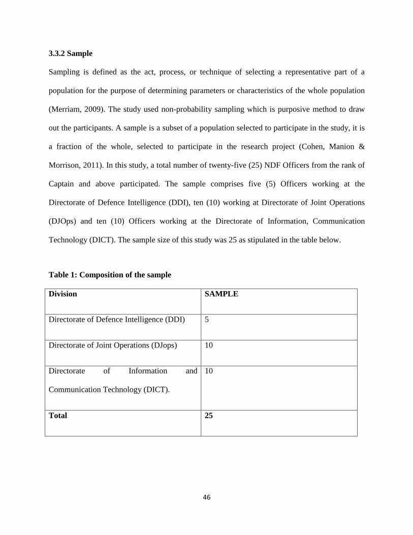
46
3.3.2 Sample
Sampling is defined as the act, process, or technique of selecting a representative part of a
population for the purpose of determining parameters or characteristics of the whole population
(Merriam, 2009). The study used non-probability sampling which is purposive method to draw
out the participants. A sample is a subset of a population selected to participate in the study, it is
a fraction of the whole, selected to participate in the research project (Cohen, Manion &
Morrison, 2011). In this study, a total number of twenty-five (25) NDF Officers from the rank of
Captain and above participated. The sample comprises five (5) Officers working at the
Directorate of Defence Intelligence (DDI), ten (10) working at Directorate of Joint Operations
(DJOps) and ten (10) Officers working at the Directorate of Information, Communication
Technology (DICT). The sample size of this study was 25 as stipulated in the table below.
Table 1: Composition of the sample
Division SAMPLE
Directorate of Defence Intelligence (DDI) 5
Directorate of Joint Operations (DJops) 10
Directorate of Information and
Communication Technology (DICT).
10
Total 25

47
3.4 Research Instruments
According to Shajahan (2009), research instrument is a tool that enables the researcher to gather
relevant data. The study employed structured interviews and the researcher wrote all the
responses from the participants on the guide. Interviews are systematic way of talking and
listening to people and are another way to collect data from individuals through conversations
(Welman, Kruger & Mitchell, 2010). The researcher opted for this data collection instrument
because it allowed the participants to get involved and discuss about their views, opinions and
experiences on challenges of geospatial technology on national security in the 21st century. In
addition, it enabled the participants to discuss their perceptions and interpretation in regards to
the situation. Throughout data collection process, the researcher had an opportunity to explain
the questions and also asks follow up questions on items or aspects that required further
clarifications. On the other hand, given the fact that Officers in the NDF are overloaded with
their day to day national duties, the interviews did not affect or delayed their busy schedules as
the researcher was present to ask questions instead of them completing questionnaires.
3.5 Data Collection Procedures
After the researcher obtains the ethics clearance letter from the University department to conduct
the study, she sought permission from the Chief of Defence Force, Ministry of Defence to
conduct a research at the NDF premises. The researcher explained the purpose of the study,
arranged the interview and discussion dates, asked the participants to signed consent letters
before interviews and discussions. Approving that they were taking part in the study voluntarily
and had understood what the study questions were all about.

48
The researcher administered interviews by asking questions, writing down the responses on the
space provided and ensured that the process was followed properly. The targeted respondents
were asked to answer questions, without necessarily divulging their identities if they wished to
do so. The participants of the study were selected on the basis that they were directly involved
with challenges of geospatial technology on national security in the 21st century.
Upon completion of data collection, responses were evaluated. For unforeseen circumstances, the
researcher made copies and stored them in a lockable drawer in her office.
3.5 Data Analysis
In this study data was analysed and presented by giving the textual report of shared views,
opinions and experiences of the officers and officials who participated in the study. Silverman
(2013), stipulated that qualitative data are organised materials to generate the meaning towards
the research questions. The aim of data analysis of qualitative data is to infer into patterns, ideas,
and explanations to understand or simplify the data discovered (Glaser, 2013). In this study, data
were analysed based on the research objectives of the study in relations to the challenges of
geospatial technology in the NDF. Data were interpreted and discussed in comparison to
information gathered in the literature review.
3.7 Research Ethics
Firstly, the researcher has recognised informed consent which involves telling the participants
about the research and their rights. The participation in the study was voluntary without any form
of cohesion or persuasion. Participants have the right to withdraw. Another aspect of ethical
consideration is confidentiality. Confidentiality refers to limits on the dissemination of

49
information disclosed by a person to a third party (Comings, 2011). The names and their
responses are not revealed instead codes were used to refer to participants. Codes used were DI
1-5 for management cadres (Colonels to Brigadier Generals) and CT 1-20 for Captains to
Lieutenant Colonel. The participants were free to ask any questions and were briefed at the
beginning of each interview session.
After the completion and examination of the thesis, the Ministry of Defence specifically the
Office of Chief of Defence Force will be given a copy of the thesis as a present for commitment
and effort toward the study. Publications will also be made available in the University library to
address gaps of literature in the country.
3.8 Conclusion
This chapter focused on the activities under the research methodology thus using qualitative
research design as the most appropriate method in analysing the challenges of geospatial
technology in the 21st century. The methodology also explained the non-probability sampling
method that was used which is purposive sampling. Overall, this chapter has outlined
methodological pertinent to the study.

50
CHAPTER FOUR: DATA ANALYSIS AND DISCUSSION
4.0 Introduction
This chapter focused on presentation and discussion of research findings. Data were collected
through structured interviews from the two participants groups namely: interviews whereby five
(5) management cadres were interviewees and 20 officers and officials regarding challenges of
Geospatial Technology on National Security in the 21st Century in Namibia. Data were presented
in themes identified to form the textual report which serve as evidence of findings upon which
conclusions are drawn.
This chapter focused primarily on the expressed perspective views, opinions and experiences of
participants on challenges of geospatial technology on national security in the 21st Century. In
the presentation of the findings, verbal statements from the respondents were used to maintain
the originality of information collected. Codes were used to refer to participants as DI 1-5 for
management cadre and CT 1-20 for Captains to Lt Col. The findings are presented and discussed
to address objectives of the study.
The rationale of the research was to explore the challenges of geospatial technology on national
security in the 21st Century in Namibia, at the Defence Headquarters in Windhoek. The research
study sought to ascertain the impacts and human security implications of geospatial technology
as well as mitigating strategies to overcome those challenges.
4.1 Demographic information
During data collection the demographic information of the participants were profiled. This was
captured with the aim of determining the gender, level of education and working experiences of
the participants. All participants were Officers and Officials of the Namibia Defence Force.

51
4.1.1 Gender
Fig. 1 Gender of the respondents
The above figure shows that of all the respondents 8 (20%) of them were females and 17 (80%)
were males officers/officials.
4.1.2 Age of respondents
During the data collection process, participants were requested to give their ages. The following
ages were recorded.
Figure 2. Ages of Respondents
15% of participants aged between 21-30 years constituted the sample, those that are 31-40 years
constituted 25% of the sample, 60% of participants aged 40 years and above constituted the
Female 20%
Male 80%
02468
10121416
Under 20Yrs
21 - 30 Yrs 31 - 40 Yrs 40 Yrs andabove
Age group ofParticipants
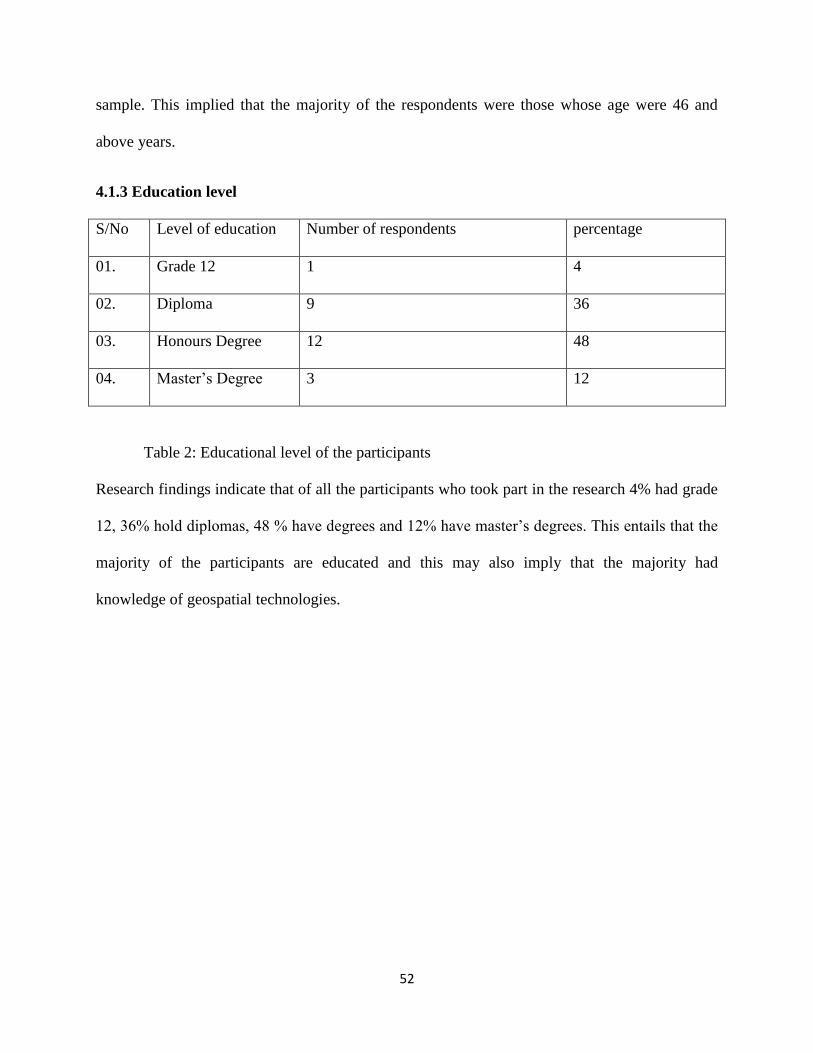
52
sample. This implied that the majority of the respondents were those whose age were 46 and
above years.
4.1.3 Education level
S/No Level of education Number of respondents percentage
01. Grade 12 1 4
02. Diploma 9 36
03. Honours Degree 12 48
04. Master‟s Degree 3 12
Table 2: Educational level of the participants
Research findings indicate that of all the participants who took part in the research 4% had grade
12, 36% hold diplomas, 48 % have degrees and 12% have master‟s degrees. This entails that the
majority of the participants are educated and this may also imply that the majority had
knowledge of geospatial technologies.

53
4.1.4 Years working in NDF
Figure 3: Working experiences for participants
The above figure shows the work experience in NDF attained by the participants. Under the
category of 5-9 years‟ experience at NDF there were 5 participants, under the category of 10 -14
years there were 9 participants, under the category of 15-19 years there were 3 participants,
under the category of 20-24 years there were 5 participants and under the category of those who
had 25 years up work experience at NDF were 3. As indicated, one may conclude that the
participants had experience in NDF. The longer one stays in an organisation, the more
information one can have as regards to that organisation.
4.2 Findings
Findings of this study were based on questions that were formulated to meet the objectives of the
study:
0 2 4 6 8 10
5 - 9 years
10 - 14 years
15 - 19 years
20 - 25 years
25+ years
years in NDF
years in NDF

54
4.2.1 Challenges of geospatial technology on national security in Namibia in the 21st
century.
In this section, the central question that was addressed by the research relates to the problems
related to geospatial technology Namibia as a country faces and how they affect national
security. The study found a plethora of challenges which include but not limited to legal
implications, difficulties in acquisition of geospatial technologies, lack of data security and
expertise among military personnel, inhibiting of privacy and suspicions raised by the use of
drones.
4.2.1.1 Legal implications
Participants indicated that there were no laws or policy in Namibia that specifically guides the
use of geospatial technologies such as drone; instead the acquisition and use of these
technologies were only incorporated in the Namibia Civil Aviation Authority (Aviation act 74 of
1962). This act was passed and gazetted to regulate airplanes and crafts only because by that
time the drones, remote sensing technologies were not in existence. Since the inceptions and use
of drones there were no tools and techniques prescribed by law of geospatial technologies for
proper usage of these geospatial technologies. Participant DI-3 said:
‘The government should introduce a law for geospatial technology practitioner in order
to use the technology ethically. This can resource to lawful geospatial data collection
practices. The practice of gathering data cannot be regulated easily for the reason that
there are no policies that guide the use of drones etc. The data being collected through
satellite imagery or remote sensing can unnecessary pose security threats to our country.
So I think that this process must be guided by laws so that the geospatial technology can
be applied in a way that ensures safety of the country’.

55
Participant DI-5 also concurred with the issue of legality of geospatial technology and said that:
‘The legal framework can deter unlawful data capturing practices by other parties. These
applications can be used by enemies and intruders to their own advantage but if there are
clear policies, laws, and rules that govern such applications, the military can collect
uncompromised geospatial information.’
Participant DI-1 stated that:
‘There is likelihood that these drones can also be used to spy on the military functions
and military trainings in the country. While some drones might be in areas where they
choose them to be not areas of interests such as coastal areas where illegal entry of
drugs and weapons can take place’.
Participants also indicated that if the country has stipulated laws with regards to the use of
contemporary/current geospatial technologies, that would create awareness on the areas of
interests, acquisitions and compliance. Hence, the legal framework can foster the development of
best geospatial practices, the identification of potential liabilities as well as risk allocation within
different departments of the NDF.
Additional, participants stated that in case of drones, it is difficult to regulate drone usage that are
privately owned by companies or individuals as some can be subjected to ethical violations.
Those who violate the ethical standards cannot be legally apprehended owing to legal
encounters. This gives room for people to temper with national security as after they can go free
without any charges brought to them.

56
The findings reflected that the impossibilities of effective geospatial technology surveillance.
This in turn pose serious national security threats since the areas of awareness are not legally
defined and monitored. Even those who transgress against Namibia cannot be effectively brought
to book because there no legal regulations in place. In this regard, Dickens (2015), argued that to
regulate dissemination of imagery and protect accessing critical intelligence data in high security
zones, developed countries have put in place and adopted Remote Sensing Policy. Hence, similar
policy is absent within the Namibian constitutions and laws on utilisation of airspace.
4.2.1.2 Difficulties in acquisition of geospatial technology
Participants indicated that Namibia as an independent country does not have its own satellites but
depends on satellites of other countries for provision of data. This hampers the effectiveness of
safeguarding the territorial integrity of Namibia. Lack of funds to acquire and upgrade equipment
such as satellite to gather intelligence incapacitate the Namibian Defence Force in areas of
sufficient monitoring the territorial waters of Namibia as well as its borders.
The study results show that participants believed that there were lack of funds to acquire up to
date geospatial technology, this was due to economic constraints that led to Defence budget cut.
However, the participants revealed the importance of latest geospatial technologies in the
modern world in regard to national security. Participant CT-7 had this to say:
‘Our defence budget is tight. The funds that we receive from our national treasury are not
sufficient enough for us to buy the geospatial technology from other countries which
manufacture them because they are very expensive’.
Participant CT-12 added that:
57
‘The equipment that is required to do satellite monitoring is quite expensive. Most of the
countries that sell such geospatial technology would want to monopolise them so they use
expensive prices as a scape goat for not selling them. Funds have not been availed to
cater for such expensive technologies. Most of the funds are dedicated to giving basic
equipment, food and rations to the soldiers’.
Moreover, these findings corroborated with Gupta (2013), Emenari et al. (2014) and Victor
(2016), findings that developing countries have inadequate funds to acquire geospatial
technology. Instead the available funds were used on ground troops and not channeling the funds
to procure equipments of gathering intelligence, yielding to undesirable consequences. The
absence of geospatial technology posed security risks to the state because threats could not be
detected and deterred on time. This entailed that the country cannot be protected effectively.
Further, Emenari et al. (2014), argued that for any security sector to effectively achieve and
outshine toward it‟s primarily objectives require proper funding. Although, there were budget
allocation increases in security sector over the past years, there are no significant changes that
were observed in the security. This implied that there are complicating issues such as corruption
amongst other affecting the proper utilization of funds for its sorely security purpose.
Likewise, these findings of study also affirmed Mallik (2014), viewed that beneficial of
technology diffusion processes in the world is only accessed and absorbed by state in possession
of maturity and scientific technological infrastructure.
The participants noted another setback in regards to acquiring geospatial technologies, that there
was reluctance by countries that have the technology to sell it or transfer the knowledge of
geospatial technologies to countries such as Namibia. Countries such as Russia and USA

58
amongst other do not sell their technology to developing countries instead they give or sell it
with cautiousness. Participant CT-4 stated that:
‘The world superpowers don’t sell their technology to us because they want to maintain
the monopoly on those technologies and use them to their own advantage. If we could at
least buy from them the latest equipment, then we could be able to operate effectively.
They only sell what they see fit and when they want to dispose of such technology’.
Mallik (2014), argued that only few countries that economical mature and have means to acquire
technologies such as nuclear submarines, strategic cruise missiles, smart weapons amongst other.
When technology leading countries such United State of America added or acquired innovative
capabilities will ensure that they maintain or keep them to themselves by heavily invest in
countering them.
4.2.1.3 Data Security
The study respondents indicated that due to the fact that Namibia hired satellites from other
states, there was no guarantee of security in terms of information gathering. Data were accessible
by the second or third parties (country that own satellites). This created problems for the security
of the country as it threatened Namibia‟s sovereignty because decisions made from the
geospatial data were in part influenced by the provider of the satellite. Since the country relied
upon rented satellites to detect threats, the information can be tempered with by another party for
example passing it on the adversary.
The study also showed that the countries that provided the satellite services also monitor the
satellites. In some cases there were no guarantees as to whether the data can be manipulated
since most of the satellite data were delayed and did not come in real time. This posed serious

59
security challenges to the country as there was no integrity in terms of the data that came from
those satellites.
4.2.1.4 Private owned Drones
Participants showed that the drones that were used in Namibia were not owned by the security
sector or agencies specifically the Ministry of Defence neither by the Ministry of Environment
and Tourism or Ministry of Safety and Security. These drones were owned by private individuals
and companies although they were used for monitoring and controlling against pouching and
illegal hunting at national parks such as Etosha and Bwabwata. This affected the security and
safety of the country adversely as those who own them can decide how to use them and where.
This may lead to the likelihood of withdrawal of the companies that own those reconnaissance
drones in the event that they choose to do so. This might affect the security of the areas
previously under surveillance and increase crime activities within the parks.
Participant CT-14 said:
‘The law enforcement agents that are responsible for provision of security in parks are
dependent on the drones that are owned by private companies or individuals’.
The presence of private owned drones in the country is a challenge because the NDF did not
have its own reconnaissance drones. Those with drones could not be monitored and they might
harbor ulterior motives and thus can use their drones against the country. Lack of drones owned
by security sectors particular the Namibian Defence Force is quite subversive in terms of
national security.

60
4.2.1.5 Lack of Expertise
Most research participants believed that there was lack of trained personnel who supposed to use
geospatial technologies. Research participants were of the view that those who were able to
understand and use the current geospatial technologies that were trained outside the country and
some of them have not transferred or shared their knowledge to others. Participant DI-1 said:
‘We do not have a lot of people trained in the area of geospatial technology. We heavily
depend on the few officers who have that knowledge most of whom were trained abroad.
Issues to do with geospatial technology require individuals who are trained to use the
sophisticated equipment and who can analyse, interpret gathered data and inform the
Commander what is on the ground.’
The finding concurred with the study in Nigeria by Adebakin (2012), that indicated that there
were a few personnel who were physical and intellectual trained to handle and encounter the
challenges of geospatial technology on the security dynamics of the 21st century. To maintain
the essential forces of security in the 21st century, the number of security personnel should be
increased to benchmark with the state population. For instance, placing the Nigerian population
against the UN on the ratio of the number of personnel, will obvious need an increase in the
force.
4.2.1.6 Psychological wellbeing
Participants believed that if community members were not well educated and could not
understand or if they refused to accept the use of geospatial technologies such as drones, this
might led to potential fears, confusion and hostility against those in power. The use of geospatial
technologies could generate conspiracy theories, suspicions especially in the marginalized
community areas like the northern side of the country where people have little exposure to

61
electronic devices. For elders, they might relate to past colonial experiences when the planes
used to drop shells and bombs.
Participant CT-2 narrated:
‘Their house, mahangu fields and kraal were bombed by planes during liberation
struggle and if they see something unknown in the air. They may fear for their life.’
4.2.1.7 Privacy challenges and suspicions raised by use of drones
Participants stated that the use of drones for example is regarded as intruding in the community
by monitoring the citizens from the air without their consent. This might become an offensive
and violation of human moralities and secrecy which is contracting organisation such as freedom
of association in the country. The community member might take the drones users to court for
privacy invasions because of taking, publishing and disseminations of images or information
without authorisation.
Participants pointed out that if a drone malfunctions and it lands in another country especially
countries that shares territorial borders with Namibia, it will create suspicions as they might
think that Namibia is spying on them. This may lead to unnecessary security conflicts between
states and it might affect their relations.
4.2.1.8 Risk of abuse
Participants pointed out that geospatial technology risk of being abused by those who have
access to satellites and drones. Participant CT-8 said:

62
‘Geospatial technology was used earlier by governments only. But this has changed;
private companies and individuals now own geospatial technologies. It is inescapable
that private companies and individuals may abuse these technologies and as such it is a
challenge as it undermines security.’
Participants believed that the abuse can range from industrial espionage, and illegal spying on
business rivals and stealing of classified information. This then inhibits national security.
4.2.1.9 Absence of central database
The participants of the study indicated that there is no one central database from geospatial
technologies that can be used by the NDF to detect threats and gather intelligence. This makes
the information obtained almost useless with regards to safeguarding the country. The central
database where the data acquired through radars, satellites, remote sensing and drones could be
useful to the Namibian Defence Force for informed decisions and strategic positioning,
enhancing its competitive advantage in contemporary security world.
Participant CT-9 narrated that:
‘We do not have a centralized database system which can be used to analyse all the
information coming in from the tools that we have, for example the military air space
radars and military satellite communications. As such our geospatial technologies
remain ineffective as a course of collective action and it is difficult to take due to lack of
information. If we could have one place where data from geospatial technologies are
processed, it would be more effective.’

63
This shows that study results converged with the past research finding by Emenari et al. (2014),
that database can be described as collection of data systematized, designed and stored in a
memory of the computer memory to be easily accessed by authorized persons. They further
claimed that with this simple description of what a database mean, it is appropriate to state that
the incorporation of information gathered from several geospatial technologies into an inclusive
database were unsuccessful in the Nigerian government. These centralised systems such as
National System for Geospatial Intelligence are crucial to military security in the modern world
to provide information to combat threats and terror activities.
4.2.2 Prevalence of geospatial technology in Namibia in the 21st century
Participants pointed out that Namibia uses Satellites, Remote sensing, Global Positioning
System, Geographic Information Systems and Drones to obtain geospatial data. GISs are used
for mapping and in the evaluation of geo referenced information. Geographic Information
Systems are used to identify environmental and geographical patterns in other data that enhance
security and military operations in the country. Traditional Geographic Information System
programmes were reserved to personnel who work in the field of geospatial data only. According
to Johnson (2015), Geographic Information Systems are suite of software tools for mapping and
analysing data which is assigned for an exact position on the Earth surface.
The study participants also noted that there were internets mapping technologies that can be used
to provide geospatial intelligence in Namibia. Internet applications such as Google earth can also
be used to provide satellite imagery of locations, objects and geographic data
The Namibian Air Force have military air defence radars that can be used to detect any incursion
that takes place in the Namibian airspace. The Namibian Navy has its naval radars that are used

64
to detect any encroachers in the territorial waters of Namibia. Participants revealed that such
technologies have been there since colonisation and they are upgraded by private companies and
individuals to meet the technological advances and contemporary challenges. These geospatial
technologies allow informational advantage and systematic attack by the Namibian Defence
Force in the 21st Century.
Participant CT-2 said:
‘I think when I first started in the military, we were using paper maps and combat radios
and you had to be an experienced map reader. But all you had was a paper map,
somebody else’s definition of what you should see in a very limited multipurpose format,
and the only means of communication we had was the radio. Recently, what has really
changed is the speed of information, the speed of connectivity, the enabling of mobile
systems, and most of all, the digital revolution and the ability to create custom products,
rather than taking somebody’s map and put overlays and spend hours trying to analyze
it.’
In support of the above, participant CT-17 said that:
‘The ability to bring information from many geospatial sources, to fuse that information
together, in some way to be able to create intelligence to meet specific operations,
specific needs, and to be able to share that with people and to collaborate even when they
are mobile, to me that’s the revolution in the NDF that has a great impact.‟
The study revealed that remote sensing entails the provision of images and data collected from
space forms the crux of geospatial data in Namibia. The Namibian Defence Force used to collect
data from zones that are very hazardous and inaccessible. It provides intelligence information to

65
the Namibian Defence Force by acquiring data in peace time to monitor the status and
development of the other state‟s forces. The combination of ground information with the remote
sensed data will analyse situations in time of war and provide more accurate, update information
to the military operations.
Moreover, private satellite image providers such as Google earth are used by people as well as
by security agencies to provide images from the satellites with definitions or resolutions. Thus,
the Namibian Defence Force gathers geospatial information from software programs and web
features such as Google Earth and Microsoft Virtual Earth respectively.
4.2.3 The impacts of geospatial technology on national security in Namibia in the 21st
century.
The Namibian Defence Force uses geospatial technologies to obtain valuable information and
data afore and throughout peace and war time. The military operations were victorious due to the
fact that geospatial technologies provided data in security aspects included terrain exploration,
deployment and combat management, intelligence gathering which enable the military
commanders to make informed decisions. The participants noted that the NDF uses military
airspace radars to detect threats thus the use of geospatial technology in the military was
effective.
They (participants) further concurred that the Namibian Defence Force uses geospatial
technology during war time to determine and search for targets to easily facilitate the operational
decisions that are crucial for combat control. They provide detailed information about maps,
locations, terrestrial pictures and territories that are necessary for solution of the military
problems.
66
The study also indicated that the NDF through partnerships with companies and individuals that
have drone technology work together to protect resources such as marine resources. For
example, between the territorial waters of Namibia and Angola, the NDF monitors the illegal
activities of illegal fish mongers. This technology offers much required national security
monitoring activities. Geospatial technologies are used in the NDF to observe the sea and
unreachable spaces. This enables the NDF to effect service remotely and thus save its human
resources for other missions rather than deploying soldiers to monitor and patrol inaccessible
areas.
The study revealed that geospatial technology is vital in giving the capacity and support to the
NDF first responders and other security persons with actual and timely information that led to
actionable and valuable insights of the situation. To substantiate this participant CT-19 said:
‘Geospatial technology has an advantage because data is manageable and it led to the
improved standards and better coordination of functions in the NDF. Advances in
satellite imagery resolution has a great impact and it provide strategic and operational
decision supports as well as deterring irregular threats to the state.’
The study also revealed that geospatial technologies have a big impact in light of the altering and
adjusting the status operation during conflict time based on the factual situational awareness.
Moreover, participants believed that in the contemporary world, technology plays an essential
part in warfare to exploit the readiness and ability of a state in response to any attack or other
security outbreak. Geospatial technology is being used as central strategic point to all measures
geared toward detecting and eliminating threats that might invade the security stability in

67
Namibia. The Namibian Defence Force uses geospatial equipment as tool to narrow down
gathered data, yielding to detailed information to do the exploration and take deterrent actions.
Participants also indicated that geospatial technology is used to foresee upcoming harms, bring
visibility to hotspot, and to improve the what if situations. For example, potential threats can be
predicted by geospatial data and past events to estimate if a future demonstration can lead to
public safety problems or not.
Research findings revealed that national security in the global arena require the use of geospatial
technology and security informatics that are aimed at advanced security informational
equipment, structures, processes and database. These improved visual analytics tools promised to
support time sensitive and undercover collaboration, critical reasoning, resolving conflict and
ability to make decisions to manage crisis and provide safety to the Namibians. Thus, in security
sphere, geospatial technologies are dynamic for surveillance, reconnaissance and target
acquisition during the military operations. Currently, Geospatial technologies serve as foundation
for the Namibian Defence Force commanders to effectively plan and execute strategic planning
as well as command and control decisions.
Participants also narrated that Namibia can detect enemies through the use of airspace radars and
naval radars. These equipment detect moving objects from the sky and water respectively. Such
technology enables the NDF to detect an aerial enemy that might attack its territorial obliged
area from the space.

68
This study revealed that various institutions responsible for maintaining the National Spatial
Data Infrastructure (NSDI) owned geospatial technologies and could access extensive spatial
data that are appropriate to the users such as the Namibian Defence Force, other security agents
and the community members. These institutions avail information to the Namibian Defence
Force which creates awareness to their intelligence experts to transform the valuable information
and recommend possible solutions to potential alarms.
4.2.4 Human security implications in the absence of geospatial technology in Namibia.
The study participants believed that in the absence of geospatial technology, human security
would be threatened. Most participants were of the views that the absence of geospatial
technology will lead to hunger and unemployment because geospatial technology are used to
detect potential areas and locate where the natural resources such as mines through GIS. If the
natural resources are discovered by some companies ultimately giving employment opportunities
to the Namibian citizen. However, if the natural resources are explored by foreigners, they may
exploit them and utilise them for self-enrichment and export to their countries for example illegal
pouching of Rhinos in our parks. The exploitation of natural resources could lead to
underdevelopment, insecurity both economically, politically and military. On the other, security
threats and war will not be detected and possible warnings will not be given for the Namibian
Defence Force to respond accordingly.
Likewise, educational and health status will not be in palm with other states, since with the
geospatial technology. One will learn through e-education and also provide health services to the
inaccessible areas through the application of geospatial technology. For example, in 2013, there

69
was flood in Zambezi Region and the Security and Safety department hired drones for delivery
of medicines to the affected community.
Research study showed that in the absence of geospatial technology in Namibia the country
would be susceptible to security threats such as terrorism. Due to the rise of global terrorism,
participants believed that the use of geospatial technology is important to monitor suspicious
movements. Without geospatial technology in the NDF, the terrorists, poachers and illegal
fishmongers could come to harm and plunder the Namibian resources leading threaten
livelihoods of the citizens.
Participants significantly indicated that without geospatial technology human security is
compromised. Without remote sensing technology, the illegal fishing boats may not be detected
and illegal and unsanctioned fishing may end up taking place. This can deplete the marine
resources and as result livelihoods would be affected. Moreover, poachers can do their poaching
without being detected. Resources like elephants and rhinos are important heritage to the
Namibians as they attract tourists who bring foreign currency into the economy.
Additional, participants articulated that without the geospatial technology, natural disasters
cannot be predicted and thus requisite action cannot be taken. In this regard, participants said that
livelihoods can be disrupted because no forewarnings would be given but disaster would strike
people unaware. Moreover, research findings revealed that participants raised concerns that if
geospatial technologies are absent, war and other security threats would be difficult to counter
and the Namibian Defence Force would not be able to protect the country.
Participants believed that the absence of geospatial technology such as satellite imagery and
reconnaissance drones have effect on human security because warfare into doubt are now
70
technological undertaken. So without the equipment defence activities which include monitoring
areas of awareness would be jeopardised. Moreover, participants believed that the policing
activities, humanitarian activities and environmental monitoring would also be difficult posing
security threats to the people of Namibia.
Moreover, participants stressed that if there are no geospatial technologies in Namibia, the NDF
would not be able to protect the state against potential enemies especial those with high techo-
space equipments. The use of geospatial technologies such as reconnaissance drones would be
important in such scenarios because they provide the NDF with the capacity to extend their
operational capabilities.
4.2.5 Suggested strategies to overcome challenges of geospatial technology on national
security in the 21st century in Namibia
Research findings proved that there is a need for joint technology world whereby information
can be shared by the NDF and other security agencies such as Namibian Police to deter threats.
In this regard, participants believed that if there would be joint venture in geospatial technology,
all states that have not yet industrialised would benefit a lot from those that have developed.
Participants believed that the joint technology world would ensure that there is information
sharing and regulation of private players would be regulated easily. Moreover, participants
believed that it would also ensure that common ground can be found both locally and
internationally in terms of policies procedures and rules that govern geospatial technologies.
Research findings also indicated that there is a need for partnerships to overcome challenges of
geospatial technology on national security in Namibia. These partnerships may be between

71
private companies with expertise in the area of geospatial technology and the Namibian Defence
Force.
Research participants also suggested that there should be proper support to aggressively drive the
use and application of geospatial technology to military and the security sector. Government
through parliamentary committees, portfolios and defence committees should offer their support
on programmes related to geospatial information gathering and evaluation.
Research results indicated that participants were of the view that there should be proper selection
of personnel to be trained and operate these geospatial technologies. In this regard, the NDF
should heavily invest in extensive human capital development to train all the security personnel
in the use of geospatial technologies and interpretations of geospatial data.
The study results suggested that the government of Namibia should acquire its own satellite
dedicated for national security use to avoid exposure of data to other country and dependency
detriments on other states. Furthermore, the participants suggested that the government should
provide an updated and modern satellite aimed at security executions only. According to the
participants, this could ensure that the military personnel effectively protect the country.
Furthermore, the participants suggested that the NDF should acquire and upgrade their own
modern airspace radars and naval radars to detect intruders within the Namibia water and space.
This is supported by researchers like Emenari et al. (2014), who opined that Nigerian
government should procure and buy other countries the satellite imageries which are dedicated
for security.
Research findings indicated that participants suggested there should be proper budget allocation
and planning to create capacity and provide a satellite dedicated to military purposes that will

72
give real time data. Moreover, the defence budget should be made as a priority toward provision
of national security. This implies that the Ministry of Defence should be funded so that it can
procure the necessary geospatial technologies such reconnaissance aircraft and UAV, satellite
and drones. Provision of funds would enable the NDF to acquire geospatial information in real
time and it would eliminate reliance on private companies and individuals.
Research results indicated that participants were of the view that all Namibian security agencies
and stakeholders such as the Ministry of Defence, Ministry of Safety and Security, Ministry of
Information and Technology and Tourism should coordinate and link common database that are
dedicated to monitoring security of the country.
Participants further emphasised that the Namibian Defence Force should form a geospatial
intelligence Unit for effective coordination of geospatial data. Emenari et al. (2014),
recommended that there should be creation of national Geospatial intelligence agency or unit in
the military for effective coordination in the Nigerian military. This ensures that analysis of data
coming from geospatial technology can be evaluated by specialised personnel and decisions can
be made as swiftly as possible rendering effective national security to the country.
Participants added that all military institutions should incorporate courses related to the data
gathering, the use of geospatial technology on national security. This finding is supported by
Emenari et al. (2014), who recommended that all military schools should be offering courses
related to surveying and Geo-informatics. This would allow military officers and officials to be
trained in various areas of counter terrorism, diffusion of bomb, use of modern gadgets and
expert in interpretation of satellite images. Moreover, they argue that government should provide
a satellite dedicated to military purposes that will give real time information. Funding of security

73
agencies should be encouraged and a mechanism that will help to fight corruption should also be
formulated to enable judicious spending of the money.
4.3 Conclusion
In a nutshell, this chapter presented findings and discussed information regarding challenges of
geospatial technology in Namibia in the 21st century. It was noted that the challenges of
geospatial technology in Namibia include legal challenges, difficulties in acquisition of
geospatial technology, lack of data security and expertise among military personnel, inhibiting of
privacy and suspicions raised by the use of drones. Namibia is gradually adopting latest
technology to acquire geospatial data. It was also noted that in the absence of geospatial
technology, human security is threatened. The next chapter gave conclusion and
recommendations.

74
CHAPTER FIVE: CONCLUSIONS AND RECOMMENDATIONS
5.1 Introduction
The purpose of this study was to explore the challenges of geospatial technology on national
security in Namibia in the 21st century. Therefore, this chapter provided the conclusions and
recommendations with reference to the findings presented and discussed in Chapter 4. The
emphasis was based on the opinions, views and experiences of participants on challenges of
geospatial technology on national security in Namibia.
5.2 Conclusions from the findings
With reference to the findings presented in the above chapter, the researcher can safely make the
following conclusions:
The study has identified from the findings that legal implications was one of the challenges of
geospatial technology. The findings indicated that there were no tools and techniques prescribed
for proper usage of geospatial technologies in Namibia. These reflect the impossibilities of
effective geospatial technology surveillance. In turn posing serious national security threats since
acquisitions and utilisation of drones were not legally defined and monitored in regards to policy
and laws.
The study also established that there were difficulties in the acquisition of geospatial
technologies because of lack of funds. Moreover, the country heavily depended on rented
satellites and did not have its own satellites. The study results revealed that since the country
relied on other countries satellites, there was inadequate no security of data gathered as the
second country also had access to that data. Research results also found out that the country did
75
not have reconnaissance drones of its own but relied on the commercial drones of private
companies and individuals to detect poachers and other illegal activities.
The study also concluded that there was a lack of expertise to operationalise geospatial
technology in Namibia. There were inadequate trained personnel to use geospatial technology in
Namibia and as such, it was a challenge to integrate geospatial technologies. Findings also
indicated that the use and application of geospatial technologies in Namibia faced a grandiose
challenge owing to community resistance especially in light of the use of reconnaissance drones
because they believe that its violation of their rights to privacy. The study pinpointed that there
was an absence of a central database system that can be used by the military to detect threats
from geospatial technologies. This made the information obtained almost useless.
The study also concluded that Namibia used geospatial technologies such as Satellites, Remote
Sensing, Geographic Information System, Global Positioning System and Drones to obtain
geospatial data. This is done through mapping and evaluation of geo referenced information to
detect geographical and environmental patterns to enhance state security.
The study proved that the use of geospatial technology in cartography, combat area management,
military deployment, intelligence, and terrain analysis allow decision makers and commanders to
obtain useful data and information before or during conflict. The NDF used military airspace
radars to detect threats thus the use of geospatial technology in the military was effective.
The study concluded that military commanders used geospatial information of intelligent maps
and geospatial data as the foundation on which they operate their solutions to make effective
command and control decisions. Geospatial technologies enable synergizing the military by

76
bringing them on a digitized platform, to combat plethora of conventional asymmetric and sub-
conventional threats in Namibia.
The study concluded that in the advanced world, the absence of geospatial technology will lead
to internal conflicts, poverty, crime activities and political instability. Geospatial technologies are
used to detect and locate potential areas enriched with natural resources such as mines, fertile
land for agriculture activities. This may result in job creation and industrialisation in the country.
Other hand the study had proved, security threats and war will not be detected and possible early
warnings will not be given for the Namibian Defence Force to respond accordingly. The
Namibian educational and health status will not be in palm with other state, since with the
geospatial technology one will learn through e-education and provide medicines to the
inaccessible areas.
5.2 Recommendations
5.2.1 Recommendations of the study
Based on the findings and conclusion, the following strategies and policies are recommended to
overcome challenges of geospatial technology on national security in Namibia.
5.2.1.1 Policy and laws for geospatial technologies in Namibia
The study recommended that the government should develop, and approve the policy, laws that
will regulates and govern the acquisition and use of geospatial technology in Namibia. This will
allow the Ministry of Defence to effectively guard against the misuse and expose the un
authorization of captured data.

77
There should be proper support through parliamentary committees and portfolios to aggressively
drive the use and application of geospatial technology strictly to the NDF and the security sector.
5.2.1.2 Joint venture in geospatial technology use in Namibia
The study recommended that there was a need for joint venture in geospatial technologies
acquisition between the NDF and other security agencies to deter threats. The partnerships will
help to overcome challenges of geospatial technology on national security in Namibia.
All Namibian security agencies and stakeholders (the Ministry of Defence, Ministry of Safety
and Security, Ministry of Information and Technology should coordinate, link common database
and form geospatial Unit dedicated to monitoring security of the country.
5.2.1.3 Human capital developmental projects on geospatial technology
To have expertise within the NDF, there should be proper selection of personnel to be trained in
operation of these geospatial technologies. In this regard, the NDF should heavily invest in
human capital development to train the officers and official the use of geospatial technology and
analysing geospatial data.
It was also recommended that courses related to the data gathering, the use of geospatial
technology on national security should be incorporated in military institutions in Namibia mainly
Military School, Namibia Staff and Command College and School of Military Science.
5.2.1.4 Prioritise on Defence budget and acquisition of satellites

78
It was suggested that the government of Namibia should acquire its own satellite dedicated for
national security use to avoid exposure of data to other country and dependency detriments on
other states.
It was recommended that adequate budget should be allocated to the Ministry of Defence to
create capacity, procure the necessary geospatial technologies and acquire a satellite aimed
military only.
5.2.2 Recommendations for further research
In view of the findings, the following academic recommendations were made:
a. The study recommended that the same study can be carried out outside Khomas Region
and to other security sectors other than Defence Headquarters.
b. It was recommended that the comparative study be carried out to explore challenges of
geospatial technology on national security between developed states and developing
state.
c. It was also recommended to investigate the necessity of geospatial technology on national
security in the contemporary world.
d. It was further recommended for a study on the human security implications of Defence
budget cut on national security readiness.
e. The researcher recommended that further studies should be carried out on the usefulness
of the recent geospatial technologies in detecting security threats.
f. The study recommended for a research that will focus on the implications of inefficient
geospatial technologies in Namibia.

79
g. Finally, a study could be carried out in other organisations such as the State Intelligence
and the Namibian Police Force to determine their challenges with regards to the use and
application of geospatial technology.
5.3 Conclusion
The chapter outlined the conclusions and recommendations drawn from the study that although
geospatial technologies are used and applied in the Namibian context for security purposes, they
were liable to challenges, which compromise human security. Thus, in order to effectively
operationalize the geospatial technologies in Namibia, provision of policy and laws a budget
dedicated to the procurement of such technologies as well as the training of military officers and
officials should be done.

80
References
Adebakin, M. A. (2012). National Security Challenges and Sustainable Economic Development:
Evidences from Nigeria. Journal of Studies in Social Sciences, 1(1), 1-30.
Al-doski, J., Mansor, S. B., & Shafi, H. Z. (2013). War Impacts Studies Using Remote sensing.
IOSR Journal of Applied Geology and Geophysics, 1(2), 11-15. Retrieved from
www.iosrjournals.org.
Anyadike, N. (2013). Boko Haram and National Security Challenges in Nigeria; Causes and
solutions. Journals of Economics and Sustainable Development, 4(5), 12-23.
Bello, I. E., & Nwagwu, J. C. (2013). Application of Geo – Information Technology to National
Security, Conflict Resolution and Trans border Cooperation: A case Study of Nigeria,
Sao Tome and Principle. International Affairs and Global Strategy Journal, 17(1).
Retrieved from www.iiste.org.
Berse, B., Bendimerad, F., & Asami, Y. (2011). Beyond geo-spatial technologies: promoting
spatial thinking through local disaster risk management planning. Procedia Social and
Behavioral Sciences, 21, 73-82.
Bhattacherje, A. (2012). Social Science Research: Principles, Methods, and Practices. Retrieved
from on http://scholarcommons.usf.edu/oa_textbooks/3.
Bridwell, S. A. (2007). The dimensions of locational privacy, Department of Geography,. In J.
Miller, Societies and Cities in the Age of instant access (pp. 209-225). Salt Lake City:
Department of Geography, University of Utah, .
81
Bryman, A. (2008). Quantity and quality in social research. . London: Routledge.
Campbell, S. H. (2013). Guide to the Study of Intelligence, Intelligence in the Post-Cold War
Period, The Impact of Technology. Journal of U.S. Intelligence Studies, 20(1), 12-31.
Cohen, L., Manion, L., & Morrison, K. (2011). Research Methods in Education ( (7th ed.).
London: Routledge.
Colonel (retired) Kedar, J. (2017). The Role of Geospatial Technology in Defence and Security,.
Retrieved from www.ordinance.survey intelligence
Comings, M. (. (2011). Research methodology: Ethical consideration in Research,
Confidetiality. . London: PHI Learning. .
Cresswell, B. L. (2014). Research methods: Exploratory research design. London: : Wiley and
Sons.
Donald, C., Cooper, D., & Schlinder, P. (2011). Business Research methods (11 th ed.). London:
McGraw- Hill Education.
Donohue, L.K. (2011). The Limits of National Security, Defining US National Security,
Georgetown University Law Center,1(2), 3-12.
Duff, M. E. (2010). Designing a Research: the Quantitative-Qualitative Debate. Journal of
advanced nursing research, 3, 130-133.
Dyke, J. (2016). National Security and Technology. New York: Cambridge University Press.
Emenari, U. S., Uwaezuoke, I. C., & Adewale, A. (2014). Application of Geospatial
Intelligencein National Security for sustainable Development to Combat Terrorism

82
Insurgence in Nigeria. IOSR Journal of Environmental Science, Toxicology and Food
Technology,, 8(9), 11 – 16. Retrieved from www.iosrjournals.org
ESRI. (2018). Geospatial Intelligence . Washington DC: US gov. www.esri.com.
Flick, U. (2011). Introducing Research Methodology: A Beginner's Guide to doing a Research
Project . London: SAGE Publications Ltd.
Gills, M. (2014). Sharing Space: Adapting Military Approaches to Geospatial analysis for
humanitarian response and the documentation of security threats. Journal of international
security studies, 4(3), 45-71.
Glenn, P. (2008). Globalisation‟s Alternatives: Competing or Complementary perspectives?
Development of Technology. International Journal of Comperative politics,, 43(1), 79-
110.
Gupta, H. (2013). From Human Intelligence to Geospatial Intelligence. Chicago: Chicago
University Press.
Guzzini, S. (2015). The History of Securitization – theory: The Cold War and what we make of it
and the return of politics. DIIS publication.
Hao, F., & Kelvin, C. (2015). Globalisation and Its Impact on Military Intelligence. Journal
ofthe Singapore Armed Forces, 41(2), 1-35.
Jackson, M., Schell, D., & Taylor, F. (2009). The Evolution of Geospatial Technology Calls
forChanges in Geospatial Research, Education and Government Management. Journal
ofSecurity Studies, 3(2), 1-14.

83
Johnson, N. (2012). Understanding geospatial intelligence. A new perspective. Journal of
international relations peace and security studies, 7(1), 1200-1241.
Kemi, A. O. (2016). The Role of Information Technology in National Security: A Case Study of
Nigeria. Global Journals Inc., USA, 16(3).
Klinkenberg, B. (2014). Geospatial Technologies and the Geographies of Hope and Fear.
Journal of Military Sciences and Innovation, 3, 81-103.
Kothari, A. (2011). Research methods in perspective. Research Methodology, . UTC: Capetown:
South Africa.
Lee, R. J. (2014). Military Use of Satellite Communications, Remote Sensing and Global
Positioning Systems in the War on Terror. Journal of Air Law and Commerce, 79(1).
Lucas, D. (2012). The utility of strategy-focused geospatial intelligence. Journal of International
Relations, Peace and Security Studies, 37(4), 525-543.
Mallik, A. (2014). Technology and security in the 21st century: A demand side perspective.
London : Oxford university press.
Marlene, C. (2011, 05 11). Geospatial Technology as a Core Tool Impacts everything from
navigating to law enforcement. National Science Foundation. Retrieved from
www.usnews.com/science/articles
Maxwell, J. A. (2012). Qualitative Research Design: An Interactive Approach. London: Sage
Publications.
84
Merriam, S. (2009). Qualitative Research: A Guide to Design and Implementation ( Revised and
Expanded from 'Qualitative Research and Case Study Applications in Education.".
Hoboken, NJ: Jossey-Bass (Wiley). .
Mouton, J. (2017). How to succeed in your Master's and Doctoral Studies. A South AfricanGuide
and Resources Book (24th ed.). Pretoria: South Africa: Van Schaik Publishers.
Naisons, A. (2010). Geospatial technology and security in the 21st century: Acase study of Iraq.
Massachussets: MIT.
NDF. (2017). Strategic Plan 2017-2022. . Windhoek : NDF.
Nueman, L. (2014). Social research methods: qualitative and quantitative approaches. .
England: Pearson education limited.
Ogata, S. (2005). Human Security: Theory and Practice, What is Human Security, St Antony's
International Review 1(2), 11-23.
Ogedebe, M. P., & Jacob, B. P. (2012). The role of information technology in combating security
challenges in Nigeria, Faculty of Science and Technology. Academic research
international, 2(1), 23-48.
Rachel, A. (2013). Geo-location privacy, national security and regulatory issues associated with
geospatial information. London: Oxford university press. .
Saggot, F. (2016). National Security in Perspective. New York: McGraw-Hill.
Sarkesain, S., John, A., & Stephen, J. (2008). US national security: Policymakers, process and
politics (4th ed.). Washington DC: Lynne Rienner.

85
Shahajan, T. (2012). Benchmarking Procurement. Technology in modern world. International
Journal of procurement, 12(4), 289-292.
Silverman, D. (2013). Qualitative research and data analysis. Sage : London.
Taureck, R. (2006). Securitization Theory and Securitization Studies. Journal of International
Relations and Development, 9, 53-61.
Truvic, K. (. (2016). The development of spatial thinking in everyday activity. Development
Review, 13(5), 93-128.
Tsvere, E. (2011). Introducing Research Methodology: How to write a research project. .
Harare: Zimbabwe : University of Zimbabwe Publications.
Victor, C. (2016). Geospatial Intelligence: Challenges and Prospects. Havard : Harvard
University Press.
Wang, B. Y., Raymond, N. A., Gould, G., & Baker, I. (2013). Problems from Hell, Solution in
the Heavens? Identifying Obstacles and Opportunities for Employing
GeospatialTechnologies to Document and Mitigate Mass Atrocities. Stability:
International Journal of Security & Development, 2(3), 1-18.
Welman, P. C., Kruger, F., & Mitchell, B. (2010). Research methodology. Cape Town, South
Africa : Oxford University Press (Pty) Ltd.
Woodhouse, T., Howarth, E., & Tien, B. (2012). Peacekeeping and international conflict
resolution. Journal of International Relations, 6(3), 56-58.
Youssef, S. (2013). The implications of National Security Safeguards on the
Commercializationof Remote Sensing Imagery,. Seattle University Law Review, 19, 539.

86

87
Appendix A

88
Appendix B
89
Appendix C
P. O. Box 29049
Windhoek
03 November 2018
The Chief of Defence Force
Defence Headquarters
P/Bag 13307
Windhoek
Dear Sir
REQUEST FOR PERMISSION TO CONDUCT ACADEMIC RESEARCH ON
CHALLENGES OF GEOSPATIAL TECHNOLOGY ON NATIONAL SECURITY IN
THE 21ST
CENTURY AT THE DEFENCE HEADQUARTERS
1. I, 17231316 Lt Col M Namufohamba at Directorate of Education and Civil Training, a
final year student at University of Namibia, School of Military Science doing Master of Arts in
Security and Strategic Studies, hereby kindly and humbly seeks permission from your good
Office to conduct an academic research on Challenges of Geospatial Technology on National
Security in the 21st Century at the Defence Headquarters.

90
2. The Study is an academic requirement for partial fulfillments of the Master Degree
programme and the outcome will be resourceful to the MOD/NDF and the state at large as it
would explore and provide strategic recommendations on how to effectively address challenges
of Geospatial Technology in Namibia.
3. I intended to conduct the research study at the three Directorates, mainly the Directorate
of Defence Intelligence, Directorate of Information and Communication Technology and
Directorate of Joint Operation. The participants of the study will be Captains rank up.
4. Data will be collected through self-administered questionnaires. Participation in the study
is voluntarily. Data to be collected will be treated confidentially and would not be passed to
unauthorized persons.
5. Kindly find the attached letter of approval from the University of Namibia, Participant
Informed Consent Form and the questionnaire for the study.
6. Counting on your usual support.
M NAMUFOHAMBA
Master of Arts in Security and Strategic Studies final year student

91
Appendix D
INTERVIEW GUIDES FOR THE STUDY
Introduction
Dear Participant(s),
My name is Martha Namufohamba (Mobile: +264 81 2993003), a post graduate student at
University of Namibia. I am doing a research for the award of Master of Arts (Strategic and
Security Studies). Please kindly assist in answering the research questions I have for the
collection of vital research data. You may answer my questions anonymously and all research
ethics will be complied to. Should you decide to exit the research process at any given stage,
please feel free to do so.
TITLE: CHALLENGES OF GEOSPATIAL TECHNOLOGY ON NATIONAL SECURITY IN
THE 21ST CENTURY: THE CASE OF NAMIBIAN DEFENCE FORCE.
Research Supervisor: Dr Torque Mude
Date Completed: -------------------------------------------------
Research Objectives
To explore the challenges of geospatial technology on national security in the 21st
century.
To establish the prevalence of geospatial technology in Namibia since the 21st century.
To assess the impacts of geospatial technology on national security in the 21st century.
To determine human security implications in the absence of geospatial technology in
Namibia.

92
To suggest strategies to overcome challenges of geospatial technology on national
security.
NB. All information given would be confidential and thus only used for the intended research
purpose(s) only. Thank you.
Expected completion Time: 45 - 50 minutes
SECTION A: DEMOGRAPHIC INFORMATION
In this section I would like to know a little about you to evaluate different users‟ opinions
Please cross (X) where necessary
1. Would you please provide me with the following information?
(a) Directorate(s): ________________________________________________________
(b) Rank: _____________________________________________________
(c) Position: ______________________________
2. What is your gender?
Male
Female
3. How old are you? Please cross the right category.
20 - 30 years old
31-40 ears old
41 – 50 years old

93
51years old and above
4. Qualification held?
Grade 12 Certificate
Three year Diploma
Four Year Degree
Other (please specify) _________________________
5. How long have you been working in the Namibian Defence Force
5-15 years
16-25 years
26+ years
6. Have you ever heard geospatial technology (Satelites, GIS, Remote sensing , drones etc)?
Yes
No
Not sure
SECTION B :STRATEGIC QUESTIONS
You can answer to your best abilities to the following questions.
1. a. Do Namibia have a policy in regard to geospatial technology?
b. What are the problems related to geospatial technology Namibia faces?

94
c. How do these problems affect national security of Namibia as a country in this techno-digital
era?
2. a. Which geospatial technologies are in use in Namibia?
b. Are all geospatial technologies registered in Namibia?
c. Does Namibia has experts in the use of geospatial technologies?
3. a. Can you relate the use and application of geospatial technologies in NDF?
b. What are the disadvantages of geospatial technologies on national security
c. How are remote sensing technology essential to national security?
4. What are the human security implications in the absence of geospatial technology in Namibia?
5. In your own opinion, what are the strategies that can be used to overcome challenges of
geospatial technology on national security?