Embed Size (px)
Citation preview

Challenges of Beach Nourishment in
Pinellas County
Nicole A. ElkoCoastal Coordinator
Department of Environmental ManagementPinellas County
October 29, 2003

Dredging for Beach-quality Sand
• Introduction: A brief history of dredging in Pinellas County.
• Present Borrow Areas:– John’s Pass– Blind Pass– Pass-a-Grille Channel– Egmont Channel Shoals
• Future Borrow Areas• Environmental Benefits and Impacts• Summary

A History of Dredging in Pinellas County
1883 1997
John's Pass John's Pass
Blind Pass
Blind Pass
Pass-a-Grille
Pass-a-Grille
N1 km
•1926-1960s: Causeway Construction•1950-60s: Dredge-and-fill construction in back-barrier bays.•1962-68: ICW dredged from Tampa Bay to Anclote River.•Impacts to tidal inlets.

Present Borrow Areas
•Inlets: John’s Pass, Blind Pass, and Pass-a-Grille Channel.
•Coupled projects•Regional Management
•Egmont Channel Shoal•Designated borrow area•>20 miles from Sand Key

John’s Pass
•Created by the Hurricane of 1848
•Federal Navigation Project authorized in 1964 – dredged by 1966
Dredging Date Volume (cu m)1960 11,0001966 59,670
1980-85 176,8301988 405,1001991 43,0002000 324,910
TOTAL 1,020,510

1926
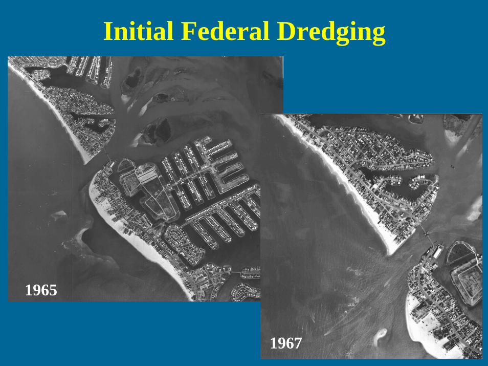
Initial Federal Dredging
1965
1967

O’Brien’s Lagoon
1971
1975
Dredging Date Vol (cu m)1971 57,000

The Borrow PitDredging Date Vol (cu m)
1969 605,0001972 115,0001976 290,000
Total 1,010,000
•First Federal Nourishment Project in Pinellas County (Treasure Island).•1970 Study: accretion rate in pit slowing, but should fill within a few years.•In 2000, the pit was about 5.5 m deep and 1.5 km long.
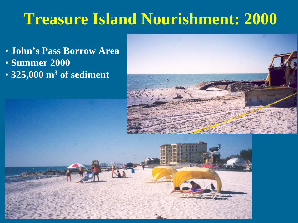
Treasure Island Nourishment: 2000
• John’s Pass Borrow Area• Summer 2000• 325,000 m3 of sediment

Blind Pass
Dredging Date Volume (cu m)1937 unknown1964 7,6001969 83,0001975 57,0001979 194,0001983 153,0001991 214,0002000 275,000
Total 983,600
•Pass predates earliest navigational charts (1873)•Not a Federal Navigation Channel•Shoaling rate: 30-40,000 m3/yr

Upham Beach Nourishment: 2000
An' up thru the ground came a bubblin' crude.Oil that is! Black gold! Texas tea!
•January 6, 2000 •Blind Pass Borrow Area•Cutterhead and pipeline•USCG and US Corps cooperation.•Oil-contaminated slurry pumped into diked retention pond.
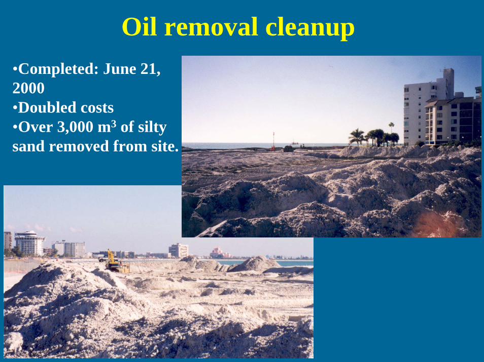
Oil removal cleanup•Completed: June 21, 2000•Doubled costs•Over 3,000 m3 of siltysand removed from site.

Pass-a-Grille Channel
Dredging Date Volume (cu m)1966 124,0001986 74,000
Total 198,000
•Federal Navigation Project authorized in 1964 – dredged in 1966•Presently, contains 680,000 m3 beach quality sand

Egmont Channel
•Dredged from 1950-70 as Tampa Harbor Deepening Project.•More than 15 million m3
of beach-quality sand remaining.
Dredging Date Volume (cu m)Dec-90 1,000,000Dec-92 1,007,000Jun-96 39,200Jun-96 172,000Oct-98 990,900Oct-99 1,007,400
Total 4,216,500

Sand Key Phase III
•Indian Shores, 1992•Dragline, barged to site•Conveyor belt transfer to beach.

Sand Key Phase IV•14 km of Sand Key nourished in 1998-99.•Cutterhead suction dredgepumped onto barges.•Sediment pumped hydraulically to beach.

Rock Removal
•Approx. 450 m3 of rock removed annually since 1999.•Tilling to a depth of 1 m, prior to turtle nesting season.

Future Borrow Areas
•Nine new offshore areas•6-9 m water depth•Contain >11 million m3 of beach-quality sand.•Dredge areas with shallow sloping sides (no pits) to aid in recolonization.•Hardbottom resources: 60-m buffer zones.•Source for 2006 Sand Key Renourishment.

Environmental Benefits and Impacts


Sea Turtle Nesting on Pinellas County
Nourished Beaches

Pinellas County Artificial Reefs
•Sand Key Nourishment permit condition•Two acres mitigation for every 1 impacted•Installed 16 new reefs, 1.5 m relief.•120-250 m offshore, 5-6 m deep•Concrete rubble

Pinellas County Dredging: Summary
• Moved from offshore disposal and borrow pits to Regional Management (channel maintenance dredging and beach nourishment coupled).
• Problems (rocks, oil, hardbottom impacts) mitigated.
• Benefits include increased habitat, navigational improvements, storm protection, and a healthy tourist industry (12.3 million visitors in 2001).
• Future Borrow Areas will decrease costs and provide beach-quality sand well into the future.