Embed Size (px)
Citation preview

Chadbourne Dam Repair and Fish
Barrier
Final Report for the Western Native Trout Initiative
Prepared by:
Carol Endicott Yellowstone Cutthroat Trout Conservation Biologist
Montana Fish, Wildlife & Parks 1354 Highway 10 West Livingston, MT 59047
(406) 222-3710 [email protected]


1
Executive Summary
Project Title: Chadbourne Dam Repair and Retrofit
Project Start Date: June 2011
Project Completion Date: December 2012
Funding
Contributor Total Renewable Resource Grant and Loan Program (Department of Natural Resources) $99,500 U.S. Fish and Wildlife Service Fish Passage Program $11,000 Future Fisheries Improvement Program (Montana Fish, Wildlife & Parks) $126,949 Western Native Trout Initiative $50,000 Lower Shields River Canal Company $14,000 Gallatin National Forest $16,000 Montana Chapter of the American Fisheries Society $5,000
Total $322,449
Abstract
The Chadbourne diversion is dam spanning the Shields River about 16 miles from its confluence with the Yellowstone River. An ancillary benefit of this diversion is that it has prevented wholesale invasion of rainbow trout into the Shields River watershed, upstream of the structure. This passage barrier has protected 375 miles of stream occupied by core populations (< 1% hybridization) of Yellowstone cutthroat trout. As a result, the Shields River watershed upstream of the diversion has the largest basin-level population of Yellowstone cutthroat trout in Montana.
Although the diversion had been largely successful in blocking invasion of rainbow trout, several features were allowing a few rainbow trout to pass over the structure. A notch intended to pass bed load and large woody debris likely allowed fish through at some flows. Moreover, repairs to prevent a scour hole from undermining the dam created roughness and decreased the height of the diversion’s face. Alarmingly, the front wall of the structure was decreasing in width, which could have resulted in catastrophic failure during floods. Indeed, a 10-ft section of wall collapsed during a large flood in 2011.
This project provided an opportunity to meld the interests of agriculture and native fish conservation. Montana Fish, Wildlife & Parks (FWP) joined forces with the Lower Shields River Canal Company to repair and retrofit the diversion, and several entities contributed to fund the

2
design and construction. The Chadbourne diversion is now reinforced, stable, and has several features that make it impassable to fish.
Project Location
The project location is at the Chadbourne diversion, an irrigation diversion located about 16 river miles from the Shields River’s confluence with the Yellowstone River (Figure 1). This watershed is to the northeast of Livingston, Montana.
Figure 1. Map of the Shields River watershed

3
Project Summary
The Shields River watershed provides substantial habitat to core and nonhybridized Yellowstone cutthroat trout. The Chadbourne diversion has had the unintended consequence of being largely impassable to fish, which has been an impediment to rainbow trout invasion. Rainbow trout are the primary cause of the declines in distribution and abundance of Yellowstone cutthroat trout (Kruse et al. 2000), so preventing them from accessing the bulk of the Shields River watershed is a high conservation priority. By excluding rainbow trout, the diversion protects 375 miles of stream occupied by Yellowstone cutthroat trout populations. Nevertheless, as the diversion was built in 1908, it has suffered the expected wear relating to its occupancy in a flashy stream that is rich in bed load and large woody debris.
The Yellowstone cutthroat trout in the Shields River watershed have substantial conservation value. This watershed is the only basin-level stronghold for Yellowstone cutthroat trout with 66% of streams historically occupied habitat still supporting Yellowstone cutthroat trout. Furthermore, this watershed is at the northern extent of the species’ native range, which provides an opportunity to conserve Yellowstone cutthroat trout where they can be resilient to climate change.
This project has been a conservation priority for Yellowstone cutthroat trout since 2004, with recognition of the potential for rainbow trout to pass over the Chadbourne diversion, and awareness of the structure’s state of disrepair and potential for failure. Annual fish surveys have found large, apparent fluvial rainbow trout upstream of the diversion, and these fish likely originate in the lower Shields or Yellowstone rivers (S.T. Opitz, FWP, personal communication). Observable spalling and erosion of concrete, and the presence of a large scour hole downstream (Figure 2), resulted in concern regarding the structural stability of the diversion.

4
Figure 2. Scour hole and concrete poured to prevent the scour hole from undermining the structure.
To answer concerns regarding structural stability and the potential for fish passage, FWP commissioned 4 studies addressing these issues (Confluence 2006; OASIS 2006; Fullerton 2010; Allied Engineering 2011). Several features were likely to allow fluvial rainbow trout to pass over the diversion. The scour hole presented a vantage for fish to use upwelling to leap towards the face of the diversion. Moreover, maintenance to protect the scour hole from undermining the structure entailed occasional concrete pours to fill the hole. This accumulation of an irregular concrete slab resulted in a decrease in the height of the diversion, and provided roughness up to the face of the dam (Figure 3). These alterations potentially provided conditions conducive to allowing fish to leap over the dam during high flows. In addition, hydraulic modeling suggested fish may be capable of passing through a notch designed to pass bed load and large wood (Figure 4). During irrigation season, the canal company installed check boards in this notch to ensure flow into the canal. For the rest of the year, the notch was open, and rainbow trout were likely to pass the notch during certain flows (OASIS 2006).

5
Figure 3. Irregular concrete slab that decreased the leap height, and provided roughness

6
Figure 4. View of Chadbourne diversion looking upstream showing sediment passage notch.
An in-depth investigation of structural stability (Allied Engineering 2011) indentified specific causes of concern for the long-term stability of the structure. The migrating scour hole was among the features that could undermine the diversion. Damage to the concrete, including cracks and voids on the east and west walls, damage to three of the seven downstream buttresses, and wear and erosion on the downstream face of the dam were other considerations. The biggest problem was the erosion that had occurred along a relatively long section of the downstream face of the dam (Figure 5). This wear had claimed between 3 and 6 inches of the wall. This wall is now a relatively thin element, and as it is constantly subjected to water pressure, it the most susceptible component of the structure. Flooding in 2011 proved the vulnerability of the face of the dam, as a 10-foot chunk fell off and required emergency repair (Figure 6). Other recommendations include repairing or replacing the three damaged, downstream abutments.
Sediment transport notch

7
Figure 5. Front wall of the Chadbourne diversion showing erosion and spalling (Allied Engineering 2011).

8
Figure 6. Broken front wall of the Chadbourne diversion and cobble berm placed to check water.
Design & Construction
The design commissioned for repair and retrofit of the Chadbourne diversion included several impassable elements (Figure 7). Installation of large, rock armor for 25 ft downstream of the concrete diversion structure will prevent formation of a scour hole that would allow fish to leap, or allow for scour that could undermine the structure. The apron of the diversion is relatively steep, which increases stream velocity, resulting in a velocity barrier. In addition, the hydraulic jump, or standing wave, downstream of the diversion increases in distance with higher flows. This feature also presents a velocity barrier, and the inability to use the hydraulic jump as a means for fish to propel them over the structure. On flat fronted diversions, a standing wave can form behind the jet of water flowing over the structure, and fish can use this hydraulic feature to breach the diversion. Modifying the face of the diversion from a flat front to a 5.2 ft high ogee eliminates those hydraulics, and forms a velocity and leap barrier to fish.

9
Figure 7. Cross-sectional view of the Chadbourne diversion repair and retrofit.

10
Construction began in August 2012. The following photographs present a visual narrative of construction.
Figure 8. Stage 1, Dewatering and building form for ogee weir face.

11
Figure 9. Installation of pipes to hold vertical planks that hold the check boards in place.

12
Figure 10. Close-up of metal frame for ogee weir.

13
Figure 11. Pouring concrete on right side of diversion.

14
Figure 12. Ogee face being shaped by hand.

15
Figure 13. Completed repair and retrofit.
16
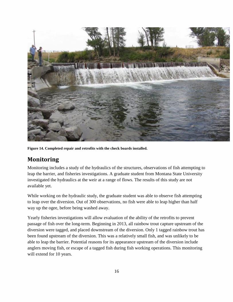
Figure 14. Completed repair and retrofits with the check boards installed.
Monitoring
Monitoring includes a study of the hydraulics of the structures, observations of fish attempting to leap the barrier, and fisheries investigations. A graduate student from Montana State University investigated the hydraulics at the weir at a range of flows. The results of this study are not available yet.
While working on the hydraulic study, the graduate student was able to observe fish attempting to leap over the diversion. Out of 300 observations, no fish were able to leap higher than half way up the ogee, before being washed away.
Yearly fisheries investigations will allow evaluation of the ability of the retrofits to prevent passage of fish over the long-term. Beginning in 2013, all rainbow trout capture upstream of the diversion were tagged, and placed downstream of the diversion. Only 1 tagged rainbow trout has been found upstream of the diversion. This was a relatively small fish, and was unlikely to be able to leap the barrier. Potential reasons for its appearance upstream of the diversion include anglers moving fish, or escape of a tagged fish during fish working operations. This monitoring will extend for 10 years.

17
Literature Cited
Allied Engineering. 2011. Stability analysis investigation: Chadbourne diversion, Shields River, Clyde Park, MT report prepared for Montana Fish, Wildlife & Parks, Bozeman, Montana
Confluence Consulting. 2006. Chadbourne diversion fish passage feasibility investigation. Report prepared for Pat Byorth, Montana Fish, Wildlife & Parks, Bozeman, MT.
Fullerton, B. 2010. Memorandum: condition of the diversion structure at Chadbourne on the Shields River. Montana Department of Natural Resources Conservation, Helena, MT.
Kruse, C. G., W. A. Hubert, and F. J. Rahel. 2000. Status of Yellowstone cutthroat trout in Wyoming waters. North American Journal of Fisheries Management 20: 693-705.
OASIS Environmental. 2006. Chadbourne diversion fish passage assessment. Task order FWP#070036. Report prepared for Scott Opitz, Montana Fish Wildlife & Parks, Bozeman, MT.