Embed Size (px)
Citation preview

Chapter 6
CULTURAL HERITAGE
6
A park for AgriTech, Hinxton ES SmithsonHill Chapter 6: Cultural heritage
Terence O’Rourke Ltd 235701b November 2017 6-1
6 Cultural heritage
Introduction
6.1 This chapter considers the effects of the proposed development at Hinxton on the historic environment, covering designated and non-designated heritage assets such as archaeological remains, historic buildings and conservation areas, and registered parks and gardens. This chapter and its associated figures and appendices should be read in conjunction with chapter 2 (site description and development proposals), chapter 9 (landscape and visual effects) and the information submitted in support of the planning application.
Legislation and policy
National
6.2 National and international policy recognises the value and significance of cultural heritage, and the public interest in the preservation of particular assets, and sets out mechanisms to ensure that it is taken into account in planning decision-making. Sites and features of identified interest are protected by the Ancient Monuments and Archaeological Areas Act 1979 (as amended), and within the planning system through the Town and Country Planning (Listed Buildings and Conservation Areas) Act 1990. Section 66(1) states that, in considering whether to grant planning permission for development that affects a listed building or its setting, the local planning authority or Secretary of State “shall have special regard to the desirability of preserving the building or its setting or any features of special architectural or historic interest which it possesses”. Section 72(1) in respect of conservation areas states that special attention shall be paid to the desirability of preserving or enhancing the character or appearance of that area. Recent case law has made it clear that it is necessary to give any harm to the setting of a listed building considerable importance and weight when making planning decisions(1).
6.3 National planning policy guidance on conserving and enhancing the historic
environment is contained within the National Planning Policy Framework (NPPF), the online National Planning Practice Guidance, and the Good Practice Advice published by Historic England (GPA1 Local plan making, GPA2 Managing significance in decision-taking in the historic environment and GPA3 The setting of heritage assets). The NPPF sets 12 core planning principles for sustainable development (paragraph 17), one of which is that heritage assets should be conserved in a manner appropriate to their significance, so that they can contribute to quality of life now and in the future. It is recognised that heritage assets are an irreplaceable resource (paragraph 126).
6.4 The detailed policies in the NPPF on development management concern the
need to clearly define the significance of any potentially affected site or area, the pre-application information requirements for any proposals, including for archaeological field evaluation, and the principles to be considered in determining any proposal for change potentially affecting heritage assets. There
1 Sullivan LJ in East Northants DC and Barnwell Manor Wind Energy v Secretary of State [2015] 1 WLR 45
at paragraph 29.
A park for AgriTech, Hinxton ES SmithsonHill Chapter 6: Cultural heritage
Terence O’Rourke Ltd 235701b November 2017 6-2
is an overall requirement to gather sufficient information to ensure an adequate understanding of the significance of an asset before any decisions affecting its future are made. The objective is to avoid or minimise conflict between a heritage asset’s conservation and any aspect of the proposal (paragraph 129).
6.5 Paragraph 131 states that in determining planning applications:
“Local planning authorities should take account of:
• The desirability of sustaining and enhancing the significance of heritage assets and putting them to viable uses consistent with their conservation;
• The positive contribution that conservation of heritage assets can make to sustainable communities including their economic vitality; and
• The desirability of new development making a positive contribution to local character and distinctiveness.”
6.6 “Great weight” should be given to the objective of conserving designated
heritage assets, and local planning authorities are required to take the significance of an asset into account when considering proposals. All harm requires “clear and convincing justification” (paragraph 132).
6.7 Paragraphs 133 and 134 define the judgement to be made in cases of harm to
designated heritage assets, based on public benefits that could outweigh the harm, taking into account the weight to be given to conservation, and whether the conflict between the provision of such public benefits and heritage conservation is necessary. A key concept in the NPPF is proportionality; that the information required, efforts to preserve, and degree of public benefits necessary to justify any harm or loss of an asset should be based on an understanding of its significance.
Local
6.8 The local planning policy in relation to heritage assets is provided by the South Cambridgeshire Local Development Framework – Core Strategy: Development Plan Document (DPD) (adopted January 2007), the Development Control Policies DPD (adopted July 2007), and South Cambridgeshire Local Plan: Proposed Submission (July 2013). Strategic objective ST/J in the adopted Core Strategy includes the aim to “ensure that the district’s built and natural heritage is protected and that new development protects and enhances cherished townscape assets of local urban design, cultural, and conservation importance.”
6.9 The Development Control Policies DPD 2007 includes policy CH/1 Historic
Landscapes, which states that “Planning permission will not be granted for development which would adversely affect or lead to the loss of important areas and features of the historic landscape whether or not they are statutorily protected.” Paragraph 8.2 in the supporting text adds that “Historic landscapes are particularly valuable in South Cambridgeshire where they add interest and variety to an intensively farmed countryside.”
6.10 In referring to development within the curtilage or setting of a listed building,
policy CH/4 states that “Planning permission will not be granted for development which would adversely affect the curtilage or wider setting of a
A park for AgriTech, Hinxton ES SmithsonHill Chapter 6: Cultural heritage
Terence O’Rourke Ltd 235701b November 2017 6-3
Listed Building. Proposals must provide clear illustrative and technical material to allow that impact to be properly assessed.”
6.11 Policies NH/14 and NH/15 in the draft local plan 2013 state:
“Policy NH/14 Heritage Assets Development proposals will be supported when they sustain and enhance the special character and distinctiveness of the district’s historic environment, they create new high quality environments with a strong sense of place by responding to local heritage character, when they sustain and enhance the significance of heritage assets including their settings.
Policy NH/15 Heritage Assets and Adapting to Climate Change Retention and re-use of historic buildings and other heritage assets will be encouraged and supported as a sustainable resource.”
Methodology
Introduction
6.12 The chapter assesses the cultural heritage resources of the site(2) and its environs as they are identified through designation, the national or local archaeological record, documentary sources or other studies. The assessment summarises the baseline information in the desk-based heritage assessment submitted to Cambridgeshire County Council (CCC) in January 2016 (technical appendix D part 2).
6.13 Following consultation with Cambridge Historic Environment Team (CHET),
additional survey work was done to help define the archaeological resource(3). An aerial photography analysis was undertaken by AirPhoto Services in March 2016 (technical appendix D part 3), which was followed by a scheme of archaeological monitoring of geotechnical site investigations undertaken by Pre-Construct Archaeology (PCA) in April 2016 (technical appendix D part 4). The results and continued consultation led to an agreed survey area of c.120 ha being set for a geophysical survey, which was undertaken by Archaeology Services West Yorkshire (ASWYAS) between August and October 2016 (technical appendix D part 5). PCA then undertook two programmes of archaeological evaluation in February, March and September 2017, consisting of 107 trial trenches across the proposed development area that targeted the identified aerial photograph and geophysical anomalies (technical appendix D part 6).
6.14 The study area covers the 108.6-hectare application site (the 101.7-hectare
main site and the 6.9-hectare bus / cycle interchange site) and a 1 km radius from the site boundary. The application boundary has changed from the site boundary used for the desk-based assessment, but the study area itself is the same. The study area has been extended where necessary to ensure all potential effects are considered and to integrate with the landscape and visual
2 The application site consists of two areas; the land to the east of the A1301, south of the A505 (the main
site); and the small area west of the A1301, north of the A505 at Whittlesford (the bus / cycle interchange site).
3 Brief for archaeological evaluation issued by Cambridge Historic Environment Team dated 11.01.16.
A park for AgriTech, Hinxton ES SmithsonHill Chapter 6: Cultural heritage
Terence O’Rourke Ltd 235701b November 2017 6-4
effects assessment in chapter 9. Figure 6.1 shows the non-designated archaeological sites and findspots in the study area, and figure 6.2 shows the nationally designated standing buildings and other built heritage features. The gazetteers in technical appendix D part 1 list the sites and built heritage in the study area and provide extracts from the Cambridgeshire Historic Environment Record (HER) and the National Heritage List for England. The data sources consulted for the assessment are outlined in table 6.1.
Chartered Institute for Archaeologists, 2014, Standards and guidance for historic environment desk based assessments
Communities and Local Government, 2012, National Planning Policy Framework
Communities and Local Government, 2017, Planning Practice Guidance (online)
English Heritage, 2008, Conservation principles – policies and guidance for the sustainable management of the historic environment
Historic England, 2015, Good Practice Advice notes (GPA1 Local plan making, GPA2 Managing significance in decision-taking in the historic environment, GPA3 The setting of heritage assets)
Terence O’Rourke, 2016, Land at Hinxton, desk-based heritage assessment
Table 6.1: References and data sources
6.15 This chapter makes use of the zone of theoretical visibility (ZTV) and
representative viewpoint photographs produced for the landscape and visual effects assessment in chapter 9, figures 9.11 and 9.13 - 9.18. The methodology for the production of these images is outlined in technical appendix G. All photographs were taken from publicly accessible locations.
Scope of work
6.16 This assessment provides a description of the likely value, extent, state of preservation and potential significance of heritage assets within the site and the wider study area that could potentially be affected by the proposals. It includes consideration of all nationally and locally identified buildings and areas and their settings. The archaeological element of the study was undertaken with reference to the Chartered Institute for Archaeologists’ Code of Conduct and appropriate standards (revised 2014).
Scoping opinion
6.17 A scoping opinion from South Cambridgeshire District Council was issued on 7 April 2017. This accepted the scope of work for the assessment as set out in the scoping request, and asked that it cover both designated and non-designated assets. It was noted that the site boundary used in the scoping report divided the garden at Hinxton Grange(4). The recognition that the site lies in a landscape of high archaeological potential was welcomed. Further information about the scoping opinion is provided in technical appendix A.
Limitations of the study
6.18 The conclusions of this assessment are limited by the level of detail about the development included in the outline planning application. The outline proposals are described in chapter 2 of this ES and the parameters for the EIA are shown in figures 2.2-2.6. Additional information on the design rationale for the overall development and the likely appearance of the buildings and landscape is
4 The application boundary corresponds to the boundaries of the garden of the house.
A park for AgriTech, Hinxton ES SmithsonHill Chapter 6: Cultural heritage
Terence O’Rourke Ltd 235701b November 2017 6-5
provided in the design and access statement. This also includes illustrative material showing the form the development could take.
6.19 Although the application is in outline, there is sufficient information about the
development to enable a properly informed judgement to be made about its likely effects on the designated and non-designated heritage assets that are identified in this assessment.
Assessment of significance
6.20 The definitions of the importance or sensitivity of the heritage assets that may be affected by the proposed development, and the magnitude or scale of the predicted change, are shown on figures 6.4 and 6.5 respectively. The generic definitions of the degree of the potential effects can then be generated by feeding the results into the degree of effect matrix (figure 6.6). Effects of moderate degree and above are classed as significant effects for the purposes of the EIA. Chapter 3 explains the assessment methodology used throughout this ES. The assessment in this chapter is a qualitative one, and the evaluation of significance is ultimately a matter of professional judgement.
6.21 This chapter first makes an assessment of the components, qualities and level
of importance or value of all heritage assets identified within the chosen study area, and the contribution to their significance made by their settings. The contribution of the surroundings in which an asset is experienced and the range of historic, functional or visual relationships, as evident in both physical attributes and perceptual values, to the significance of any single asset or group of assets will depend on the nature of the asset and its past and present setting. The importance of the setting of an asset, or of particular views or vistas (both deliberately designed, and the result of incidental or fortuitous changes over time), to its significance, and to how it is understood and appreciated, can therefore vary greatly.
6.22 The assessment of value, coupled with reference to national and local
legislation, relevant policy statements and best professional practice, allows a judgement to be made of the significance of the asset and its sensitivity as a receptor. The focus is the inherent value and importance of the historic asset itself, which is clearly separated in the assessment from any public amenity value particular sites may have, or potential contribution to tourism or other interests.
6.23 The judgement of the magnitude of change likely to occur is based on available
information on the attributes of the proposed development: for example, immediate changes such as ground disturbance for site preparation and construction, the removal of existing structures, routes or trees; changes to drainage and land form, or the addition of new structures and transport networks; and changes to views of, from or across heritage features, or to perceptions of their priority in the landscape. The likely effects of development on the settings of heritage assets depend primarily on the fundamental characteristics of the development, although detailed design can also have an influence.
A park for AgriTech, Hinxton ES SmithsonHill Chapter 6: Cultural heritage
Terence O’Rourke Ltd 235701b November 2017 6-6
6.24 Guidance produced by Historic England (2015) provides advice on a consistent framework for the assessment of the effects of development on heritage assets and their settings. The assessment in this chapter encompasses the identification of assets that may be affected, of the contribution of setting to the value of those assets, the description of the attributes of the proposed development and the assessment of likely significant effects.
Baseline
Introduction
6.25 An outline of the known archaeology and built heritage of the site and a 1 km radius study area is given in the desk-based heritage assessment in technical appendix D part 2, so it is not necessary to give more than a brief summary here. Since the production of the desk-based assessment, more analysis has been completed on the heritage assets within the landholding. Additional information is provided on the phases of archaeological survey and evaluation work, and the full reports can be found in technical appendix D parts 3 – 6. Information is also provided on Hinxton Grange and its designed landscape setting, including a map regression exercise, in technical appendix D part 7. This describes the relationship and value of the components of the designed landscape setting, consisting of the gardens close to the house, the square of enclosed parkland, the long avenue approach through the agricultural fields and the woodland belts rising to Round Plantation.
Geology
6.26 The western and central part of the main site is underlain by the solid geology of the Holywell Nodular Chalk Formation, and the eastern part by the New Pit Chalk Formation. The bus / cycle interchange site is again underlain by the Holywell Nodular Chalk Formation, with a thin ribbon of Alluvium in the western part and the remainder covered by River Terrace Deposits.
The heritage resource
6.27 The evidence is presented in chronological order in broadly accepted chronological periods such as Palaeolithic – Neolithic. A total of 93 non-designated assets are listed in the historic environment record (HER) data for the site and 1 km radius study area.
Prehistoric
6.28 There are few recorded early prehistoric sites in the study area, only an artefact scatter of Early Mesolithic to Late Neolithic date (TOR36) and a group of Late Mesolithic flints and environmental evidence at Whittlesford Bridge (TOR68). Neolithic flints have been found at Sawston (TOR56, 57) and Pampisford (TOR64).
6.29 Investigations at Hinxton Quarry to the west of the main site revealed a high
density of surface lithics and burnt flint (TOR47), and a series of pits of Neolithic / early Bronze Age date (TOR52). Two Bronze Age cremations were also revealed in a ring ditch (TOR46). Other Bronze Age records in the study area
A park for AgriTech, Hinxton ES SmithsonHill Chapter 6: Cultural heritage
Terence O’Rourke Ltd 235701b November 2017 6-7
are an inhumation with a beaker pot uncovered at Whittlesford (TOR37), and cropmarks of six possible Bronze Age ring ditches and enclosures 650 m west of Park Hall, Great Abington (TOR3-8). An evaluation at the A505 / A1301 ‘McDonalds’ roundabout revealed a single Iron Age ditch containing late Iron Age pottery (TOR43). The Hinxton Quarry investigations found eight cremation burials accompanied by Late Iron Age pottery and metalwork, five enclosed within ring ditches (TOR51). The cemetery was re-used for burials in the Roman period and was truncated by several phases of later Roman field systems.
Romano-British
6.30 The study area lies within a landscape that was extensively exploited during the Romano-British period. The A11 preserves the route of the Roman road to the town and fort at Great Chesterford. There are a number of chance finds of this period in the study area of pottery (TOR13) and of metal objects (TOR19, 20).
6.31 Investigations in the study area have identified numerous sites and features from
this period. An area south of Pampisford Park (TOR15) revealed pottery but no structural evidence, pits or ditches, and may be associated with the enclosure visible as a cropmark (TOR82). To the east, on the A11, investigation of an area of cropmarks uncovered undated ditches along the same road alignment (TOR21) and evidence of a building with stone foundations and a concrete floor, and large quantities of tile, mortar and pottery. A roadside temple / shrine is suggested. Ditches, a rectangular enclosure and field boundaries dating to the 1st-4th centuries AD were uncovered at Hinxton Hall (TOR22).
6.32 The investigations at Hinxton Quarry revealed a rectilinear, ditched enclosure
system producing 2nd-3rd century pottery (TOR53). There were sub-divided fields / paddocks on either side of a droveway (TOR50) and occupation material suggesting a settlement in the vicinity. The skeleton of a child was found in part of one of the paddocks. Further Roman inhumations were interspersed among rows of ring ditches (TOR54).
6.33 Excavations in Duxford (TOR30) revealed a number of Romano-British ditches
forming part of a possible temenos (a boundary surrounding a temple / shrine site). Site investigations south of the A505 initially identified a series of Roman ditches (TOR31) and subsequent excavation revealed an early Roman pottery production site (TOR75) and two adjoining curvilinear enclosures surrounded by large ditches. The pottery suggests a short time span for production at the site, from 50-80AD. East of the railway, cropmarks of Roman enclosures were confirmed through evaluation in advance of gravel extraction (TOR59). One internal feature was tentatively identified as the foundations of a corn-drying oven (TOR61).
6.34 Cropmarks indicate two possible buildings where a scatter of Roman
occupation and building debris was found south west of Rectory Farm, Pampisford (TOR84) and fieldwalking to the south produced a small quantity of 4th century Romano-British pottery and cattle bones (TOR60). An extensive complex of cropmarks is identified on the lower slope of a gravel ridge on the west side of the River Cam floodplain (TOR91/SM DCB37). No trace could be seen on the surface, but a heavy scatter of Roman building debris marks the site and further ditches, pits and enclosures are discernible on the aerial
A park for AgriTech, Hinxton ES SmithsonHill Chapter 6: Cultural heritage
Terence O’Rourke Ltd 235701b November 2017 6-8
photographs. There are indications of possible buildings in a field to the east of the A11 (TOR34) and fieldwalking produced a large quantity of Roman pottery and some contemporary coins.
Early medieval-medieval
6.35 The most significant remnant of organisational Saxon rule is the section of the Brent Ditch (TOR 79/83; SM DCB14), which forms one of four defensive dyke earthworks in Cambridgeshire. The Brent Ditch runs from low ground on the eastern side of Pampisford up onto the high ground across the Icknield Way to the plateau in Great Abingdon. The 2.5 km long earthwork comprises a flat-bottomed ditch with steep sloping sides flanked by two banks.
6.36 At Hinxton Quarry 11 ditches were tentatively dated to the Saxo-Norman period
(TOR45). A group of pits and ditches of probable medieval date was also recorded, with one containing burnt clay and carbonised material of a possible kiln or corn dryer. Further excavations revealed evidence for Saxon settlement in the form of two grubenhauser (sunken rectangular houses) with domestic refuse pits dating to between the 5th and 7th centuries AD (TOR48). There is documentary evidence for an Anglo-Saxon hundred or wapentake meeting place close by to the north west at Whittlesford (TOR58).
6.37 Features of probable medieval origin are a series of headlands and ridge and
furrow to the north of the site (TOR12) and a large flat-bottomed depression, cut into the chalk natural (TOR14). A linear feature or hollow way running south west–north east is visible on aerial photos immediately to the south (TOR32).
Cropmark features (undated)
6.38 A number of the cropmark features identified from aerial photographs remain undated. There are several within the application site: a large square enclosure (TOR87) and parts of several smaller rectilinear enclosures (TOR88, 89), plus a round feature (possibly a pond) and a possible bank or roadway (TOR17). A tentative medieval date has been suggested. To the south of Round Plantation, sites TOR11, 18 and 90 denote the cropmarks of enclosures and two ring ditches. Cropmarks of a series of ditches, rectangular enclosures and a ring ditch are sited immediately north of the site, to the south of the A505 (TOR16, 86).
6.39 Other cropmarks within the study area are the curving ditches (TOR 2) of a
possible medieval deer park at Abington (HER4), linear features related to the line of the Brent Ditch (TOR80), enclosures and a ring ditch to the north of the site in Pampisford (TOR9, 82), and a rectilinear enclosure north east of Field Farm Cottages (TOR85).
Built heritage and historic landscape
6.40 At Domesday Hinxton was named as Hestitone and the survey records 38 households and three mills. The population changed little over the medieval period. The linear form of the medieval village was tightly built along a single street, with the farmsteads integrated into the high street. A series of fires in the 17th and early 18th centuries opened up gaps that were not rebuilt, resulting in
A park for AgriTech, Hinxton ES SmithsonHill Chapter 6: Cultural heritage
Terence O’Rourke Ltd 235701b November 2017 6-9
the present sporadic pattern. By 1615 the main road had shifted to the east to its present course, though the former alignment is legible in tracks through the fields to the north. The form of the village was changed again in the early 19th century by the creation of the park at Hinxton Hall, which removed a southern portion of the village.
6.41 There was a parish church at Hinxton by 1092. The present building retains
fabric from c.1200, but dates mainly from the later 14th and 15th centuries (LB24, grade II*). The church at Pampisford (LB49, grade II*) has Norman features, including a tympanum (a recessed triangular space between the lintel and the arch) over the doorway. Both churches have low towers and distinctive narrow needle spires. The former chapel of the Hospital of St John the Baptist at Whittlesford (LB33, grade II* and SM 24432) served a small wayside hospital. The surviving building relates to a phase of rebuilding from c.1330 and overlies earlier buildings. The adjacent 16th century Red Lion Inn (LB34) is built over the probable location of the infirmary.
6.42 There are several examples of late medieval domestic buildings in Hinxton. No.
29 High Street (LB23, grade II*) is a 15th century guildhouse that was converted to a manor house in c.1580, and the adjacent no. 31 (LB21) is a 15th century hall house. At the north end of the high street no. 105, The Oak House, (LB4, grade II*) is a former courthouse or woolhouse that again was converted to a dwelling in the late 16th century. Buildings with early 16th century origins are Lordship Farmhouse (LB10), Hall Farmhouse (LB12) and nos. 50 and 52 High Street (LB14). Lordship Farm has a partial moat that may relate to an earlier medieval house (TOR92). Large numbers of the other buildings in the village are of 17th century date, including the jettied Red Lion Inn (LB22).
6.43 In the 18th and 19th centuries, specialised buildings were added at the farms
within the village street and at Lordship Farm (LB5, LB8 and 9). The present mill buildings (LB11) consist of the late 18th century mill and adjacent older cottage. A mill was recorded on this site alongside Lordship Farm by 1698 (TOR92).
6.44 The first house at Hinxton Hall to the south of the village was built in 1737. The
present house (LB27, grade II*) replaced it between 1748 and 1756, and was expanded in several phases, including the early 19th century addition of the stables courtyard with Islamic-style towers and the game larder (LB28, 29). The south end of the village street was removed to allow the creation of the park from 1833 onwards and excavations here have uncovered former medieval house platforms (TOR72). The Ickleton road was diverted around the new park and New Road was also constructed at this time.
6.45 Pampisford is first recorded in 991AD. The older part of the village consists of
rows of houses set directly onto the main street, though recent development has resulted in a more dispersed pattern. There are 16th century houses at nos. 6 and 7 High Street (LB35, LB44), though most of the older houses are 17th century, predominantly single storey and thatched (LB37-42). The older part of Sawston is beyond the 1 km study area, as is Sawston Hall, a 16th century courtyard house now set within a wooded and enclosed 19th century designed landscape included in the national register of parks and gardens at grade II. Duxford was in a different form from the other villages, based on two parallel streets, with two churches, that had been separately founded by the
A park for AgriTech, Hinxton ES SmithsonHill Chapter 6: Cultural heritage
Terence O’Rourke Ltd 235701b November 2017 6-10
12th century by the holders of the two main manors. Again, most of the village is beyond the study area, except for an 18th century mill and millhouse (LB30) in a location on the river occupied by a mill since Domesday.
6.46 The rural landscape was substantially reorganised in the early 19th century as a
result of formal parliamentary enclosure and a phase of creation of new country houses and designed landscapes from the formerly agricultural land.
6.47 The new house at Pampisford Hall was built after 1812 and was expanded
several times over the course of the 19th century. The parkland and woods were laid out between 1820 and 1831, and had increased to the existing size by the 1860s. The house is secluded within the parkland, which is dominated by woodland and planting of specimen trees. Views beyond the park boundaries to the surrounding farmland are not a feature of the designed landscape. There is one internal straight axial view along Cedar Avenue through woodland running parallel to the Brent Ditch. The designed landscape is included in the national register of parks and gardens at grade II*, principally for the interest of the arboretum begun in the 1820s. The park falls just outside the 1 km study area.
6.48 The enclosure of Hinxton parish led to the further concentration of land
holdings, and creation of a new estate by Wedd William Nash, who held nearly two-thirds of the parish. The new estate at Hinxton Grange, built in 1835, consisted of a formal house (LB1) with stables and coachhouse (LB2), pleasure grounds and a walled garden, set within a small square park, with a separate farm and three cottages at New Farm to the north. Some of the main boundaries between the open fields were retained in the new field layout, such as the long east-west aligned tracks, one the parish boundary. An account of the history of Hinxton Grange and map regression is given in technical appendix D part 7.
6.49 During WWII, Hinxton Grange was in use as an anti-aircraft battery HQ, and the
HER records the site of a searchlight as well as the extant type 22 pillbox on a track on the south of the main site (HER1, HER3). Thirteen sites of destroyed pillboxes are recorded in the study area (TOR25-27, 40-42, 65, 66 and 73, 74).
Results of archaeological investigations
6.50 A total area of c.239 ha was the subject of an aerial photograph analysis by AirPhoto Services in March 2016 (see technical appendix D part 3) and the results are shown on figure 6.7. Buried cut track ways, enclosures, boundaries, pits, funerary sites and foci of settlement indicate the presence of an eroded multi-period archaeological landscape dating from prehistory through to the Roman and medieval periods within the site and its immediate environs. Analysis of visualised LiDAR data has indicated the presence of eroded headlands of a system of medieval fields within the site.
6.51 The aerial photo analysis demonstrated the presence of complex multi-period
settlement recorded primarily as marks in crops and soil, including likely Bronze Age funerary sites, complex settlement enclosures, possibly dating to the Iron Age – Romano British periods, a possibly high status Roman settlement area, pits, tracks and a buried medieval road. These probable sites are set within a wider landscape with known and excavated examples of archaeological sites of
A park for AgriTech, Hinxton ES SmithsonHill Chapter 6: Cultural heritage
Terence O’Rourke Ltd 235701b November 2017 6-11
likely Bronze Age date, such as funerary monuments (TOR3-8), Iron Age and Roman settlement (TOR78 and 84), with other tracks, boundary ditches and features indicative of an organised settled from early prehistoric times.
6.52 A scheme of geotechnical site investigations on site was monitored
archaeologically by PCA in March 2016 and the results are presented in technical appendix D part 4. A total of 53 geotechnical pits and one borehole were monitored. With the exception of three residual Late Mesolithic or Early Neolithic flints, no archaeological features or finds were seen during monitoring.
6.53 A geophysical survey of 120 hectares was undertaken by ASWYAS between
August and October 2016, the results of which are provided in technical appendix D part 5 (figure 6.7). Many features, or anomalies as they are referred to prior to intrusive investigation, were considered to have limited potential, such as ferrous (magnetic) material either on the surface or ploughsoil; geological anomalies caused by variations in the depth and composition of soils; agricultural anomalies such as ridge and furrow cultivation marks along the south western part of the site; a possible Second World War ‘zig-zag’ ditch-like feature (W1) and an inferred line of posts (W2) possibly associated with an anti-glider instalment (ASWYAS 2016, 5).
6.54 A large number of probable and possible archaeological anomalies were
detected within all the areas surveyed. These comprised linear ditches, probable ring ditches (ploughed-out remains of Bronze Age burial barrow monuments), pits, enclosures and trackways. The majority of Area A, east of Whittlesford, no longer lies within the application boundary, but at least six anomalies were identified during the survey: a ‘D-shaped’ anomaly (A1), a possible ring ditch (A2), a spread of c.27 pit-like features (A3) and other circular anomalies (A5), all of which were interpreted as being contemporary by the surveyors (ibid. 6). It is also worth noting that Area B, a field north of the tree-lined avenue to Hinxton Grange, largely remains outside the application boundary but possesses some of the strongest magnetic responses. A rectilinear enclosure sub-divided into smaller rectangles measuring 136 m x 86 m is likely to be the foundations of a Romano-British farmstead building / villa (A7) and has been previously identified by aerial photo analysis and in the HER (TOR86). Extending for c.500 m in a north west–south east orientation from this building are two parallel linear responses, 7 m wide, which appear to be a formal track associated with the villa (A8).
6.55 The majority of the survey area lay to the south and south east of Hinxton
Grange, although a portion in the far south eastern corner was unavailable for survey because of the presence of crop trials. Two distinct anomalies of archaeological origin were identified in Area C close to the western boundary of the main site: two parallel linears (A10), on a similar alignment and width to an anomaly recorded north of the avenue (A9), recorded for a length of c.300 m in a north-south orientation. To the west of this linear, a circular anomaly measuring 21 m x 19 m may be a ploughed-out burial barrow feature (A11). Two distinctive rectilinear features were surveyed further south of A11 and may be contemporary in date (see figure 29 technical appendix D part 5).
6.56 The large open field immediately south of Hinxton Grange, Area D, also
produced a number of probable / definite archaeology anomalies. A circular
A park for AgriTech, Hinxton ES SmithsonHill Chapter 6: Cultural heritage
Terence O’Rourke Ltd 235701b November 2017 6-12
anomaly measuring c.18 m x 20 m with a strong magnetic response and what appears to be an internal pit or burial deposit was recorded (A13), with a likely linear representing a former field boundary bisecting it (A12). Two similar circular anomalies comparable in size with A13 are recorded on the eastern extent of the survey area (A18 and A19). A group of five circular responses measuring c.7 m x 7 m (A15) lying either side of a linear ditch and parallel with A12, and a c.590 m linear (A14) broadly parallel with A12, were recorded in the southern portion of Area D. While some correspond to cropmarks identified by the aerial photography analysis, a number were previously unknown and unrecorded.
6.57 In line with the design brief for archaeological evaluation (CHET, January 2016),
the results of the non-intrusive surveys and the iterative master plan proposals were discussed and a strategy was agreed for trench evaluation in consultation between CHET and the preferred archaeological contractor, PCA. A written scheme of investigation (WSI) was produced in January 2017 and, following minor trench alterations, was endorsed in time for trenching to commence in February. The agreed WSI allowed for 107 trenches varying between 54 m x 30 m and 35 m x 50 m, totalling an area of investigation of 3,370 m2. A total of 48 trenches contained no archaeological features but did in certain circumstances contain tree throws and natural hollows / geological features (PCA 2017, 14). There was a discrepancy of 2-4 m between the geophysics and the physical remains of the archaeology features, which is to be expected on a site of this size (PCA 2017, 67).
6.58 The evaluation revealed a range of remains that could be assigned to five broad
periods: Neolithic to Early Bronze Age (2,900-1,500BC), Early to Middle Bronze Age (1,500-1,150BC), Late Bronze Age to Early Iron Age (1,100 – 400BC), Middle to Late Iron Age (400BC – AD40) and Romano-British (40-400AD). The natural topography greatly influenced how the site was utilised during these periods. The earliest activity was recovered from a pit in the south western part of the site (trench 67, figure 6.8) from which Late Neolithic / Early Bronze Age pottery and flint indicates contemporary activity in the vicinity near to the river terrace gravels at 23 m AOD. Bronze Age activity was prevalent across the site, from burial barrow monuments on the chalk-ridge in the north eastern part of the site (c.46 m AOD; trenches 41, 79 and 80) and on the low ground in the west of the site (c.26 m AOD; trench 18).
6.59 The round barrows were related to, and became established due to their
proximity to, settlement also of Middle Bronze Age date, which took the form of three large rectilinear enclosures on the west of the main site, probably exploiting the more fertile agricultural land and the south west facing slopes (PCA 2017, 66). These enclosures indicate a phase of formal settlement and organisation. Two linear ditches in trenches 18 and 26 form a rectilinear enclosure in excess of 77 m long and 36 m wide extending beyond the western limit of the site (see figure 6.8). A second enclosure in excess of 113 m long and 63 m wide was identified from the ditches, which formed the eastern corner in trenches 29 and 30. No western or southern extent was uncovered. A third L-shaped anomaly was targeted in trench 42, and it was found that this enclosure could measure in excess of 81 m long and 21 m wide, with no southern extent and the western portion beyond the site limits once again.
A park for AgriTech, Hinxton ES SmithsonHill Chapter 6: Cultural heritage
Terence O’Rourke Ltd 235701b November 2017 6-13
6.60 In conjunction with aerial photographs and geophysical anomalies (A10 on figure 6.7), six trenches identified a triple ditched boundary (trenches 5, 12, 19, 27, 29 and 43, see figures 6.7 and 6.8). The alignment was north-north west to south-south east, with large gaps along the course of the three ditches, which had a combined width of 15.8 m, with gaps of 3.5 – 3.9 m between the ditches, which all had similar depth and profiles (ibid. 26). Evidence was scarce from the slots dug into each of the three ditches, but they have been dated to between Late Bronze Age / Early Iron Age (ibid.).
6.61 The Early to Middle Iron Age saw the reorganisation of the landscape, with two
areas of settlement identified, one to the north west first shown as geophysical anomalies A1-5, and a second in the south east, anomalies A14-16 (see figure 6.7). The northern settlement evidence was revealed in trenches 1-3 in the form of a ring gully, 30 m in diameter, and associated boundary ditches 75 m further west of the ring gully and possibly indicating the delineation of a settlement. A relatively large assemblage of Middle Iron Age pottery was recovered from the ring gully. It is likely that this settlement is associated with a more complex configuration of circular anomalies and ditches c.250 m north in Area 1.
6.62 A second settlement was revealed in trenches 85-87 in the south eastern part of
the main site, where two ring gullies, c.8.5-9.9 m in diameter, were evaluated, and a further two were identified in the geophysical survey with associated boundary ditches and pits. The ring gullies were bisected by a boundary ditch present in trenches 85 and 87, which would have provided the division between separate plots of land within the settlement (ibid. 32). To the immediate west of this second settlement area, a possible square or rectilinear enclosure contemporary with the roundhouse evidence in trenches 85 and 87 was revealed in trenches 63, 73, 74 and 77 (see figure 6.8). It is possible this enclosure represents land division or a square boundary claiming a portion of this landscape for the adjacent settlement.
6.63 Land divisions were seen in two well preserved north west to south east
boundaries, one present in trenches 27, 31, 46, 47 and 62 and a second in trenches 9, 17, 39 and 41. The former measured a maximum of 1.45 m in width and 0.6 m in depth at its western extent, and increased to 3.67 m wide and 0.95 m in depth at its eastern end, but finds were scarce. The second boundary was much more truncated and was tracked with the aid of geophysical and cropmark information. The projected alignment of this ditch traversed through the Bronze Age ring ditch seen in trench 41, but no evidence of the ditch was present in this trench, indicating that it only truncated the mound deposits (ibid. 35), suggesting the truncation of any funerary remains that were once placed within this monument. A grain storage pit was revealed in trench 40 that should indicate settlement in the vicinity, but no datable evidence was retrieved that would definitively place this feature with the nearby Iron Age settlement. A trackway was identified in zone 2 during the phase 2 evaluations orientated north east to south west between trenches 98, 106 and 107. This trackway appears to be linked to a perpendicular trackway that leads to a potential Roman villa to the north, but no dating evidence was recovered to confirm whether the trackway was contemporary.
6.64 Very little evidence for Roman activity was present on the site. This is surprising
given the results of the geophysical survey, especially the rectilinear enclosure
A park for AgriTech, Hinxton ES SmithsonHill Chapter 6: Cultural heritage
Terence O’Rourke Ltd 235701b November 2017 6-14
sub-divided into smaller rectangles (likely to be the foundations of a Romano-British farmstead building / villa), as well as the recorded Roman settlements to the north (TOR84), pottery production site with six kilns (TOR75) to the north west and the settlement east of the Roman road alignment (TOR76-78). A possible enclosure identified in trench 3 in Area A revealed the corner of a small rectilinear or square enclosure, but the dating is based on the retrieval of one sherd of Roman pottery (a total of only eight sherds were recovered from this evaluation). Medieval relic headlands were identified in the aerial photography survey (highlighted yellow on figure 6.7) and represent the most recent activity and formal organisation of the site. A number of features in the centre of the main site, which initially appeared to be ring ditch and / or circular enclosures, were proved to be large geological hollows. None of these hollows appear to have been utilised for collection of flint waste or flintworking, as was the case to the west at Hinxton Quarry (TOR 47, 52), and the few finds recovered are indicative of gradual infilling.
Assessment of importance
Archaeology
6.65 The study area contains a high proportion of records in the HER, including two(5) nationally designated scheduled monuments, from the early prehistoric through to the medieval period, reflecting a landscape that has been attractive for settlement, land management and burial above and close to the River Cam valley. Archaeological investigations in the study area have revealed many sites dating to the Iron Age / Romano-British periods, when the landscape was extensively exploited to meet the needs of a settled community. Only five recorded non-designated heritage assets fall within the application site area, four of which are undated cropmark features. The archaeological resource within the study area is considered to be of medium to high importance.
6.66 The results of the trench evaluation generally corroborated the extent of
probable / possible archaeological anomalies identified in the aerial photography and geophysical surveys (figure 6.7). The multi-period landscape that has been revealed was initially identified by the variation in ditch orientations seen in the non-intrusive survey results. Dating evidence was scarce, although most features were considered to belong to one of the main periods through a combination of shared alignments and stratigraphy (ibid. 75). Some Neolithic evidence, however transient and fleeting, was revealed in the pit and in the concentrations of flint recovered from the ploughsoil around trench 67. Similar contemporary and artefactual evidence was recovered from the Hinxton Quarry excavations, but no direct evidence for dwellings was present (ibid. 68).
6.67 The presence of the Bronze Age ring ditches / barrows in close proximity to
contemporary evidence for enclosures / land organisation is not unusual and the summit of the chalk ridge on the eastern side of the main site is the ideal setting for such monuments. No human remains / burials or artefacts were recovered from any of the ring ditches and the lack of mound deposits may suggest complete truncation, especially across the chalk ridge. The series of ditches
5 A third scheduled monument, the Hospital of St John the Baptist (SM 24432 / LB33, grade II*) is
considered as a built heritage asset.
A park for AgriTech, Hinxton ES SmithsonHill Chapter 6: Cultural heritage
Terence O’Rourke Ltd 235701b November 2017 6-15
containing Middle Bronze Age pottery formed large enclosures and are indicative of organised contemporary settlement, even though no evidence of dwellings was identified, again a possible result of the level of truncation (ibid. 71). Clear settlement evidence was recovered from trench 30 in the form of domestic pottery, while all three rectilinear enclosures close to the western boundary would have been sited on free draining gravels ideal for settlement and close to the agriculturally attractive chalk slopes.
6.68 The most extensive remains found on the site are Iron Age ditches with
variations (in alignment and profile) indicative of more than one phase of settlement / agricultural activity. The boundaries were part of a widespread reorganisation of the Iron Age landscape, while appearing to have been intentionally placed / aligned to respect the burial barrows prominently sited to act as ‘markers’. The ditches are boundaries associated with a settlement area identified in the south east corner of the site in trenches 85-87 (see figure 6.8), sited on the higher ground and positioned to exploit the agriculturally attractive west-facing slopes. Little Roman evidence was recovered from the site, which was surprising considering the known evidence in the study area and the presumed rectangular structure and formal trackway identified as A7 and A9 in the geophysical survey (figure 6.7). The only exception is the enclosure in trench 3 to the north west, where the corner of a rectilinear / square enclosure was identified.
6.69 The ability to understand and interpret any archaeological evidence tends to be
diminished in proportion to the extent of its removal or replacement. The application of several non-intrusive surveys followed by targeted evaluation trenching within the site has led to a greater understanding of the survival and significance of the multi-period archaeological resource. PCA concluded that the results of this evaluation are comparable to the nearby archaeological investigations such as Wellcome Genome Campus, Clay Farm, Trumpington and Babraham Road. Where archaeological deposits have been shown to still be present on site, and organised for settlement and land management since at least the Middle Bronze Age, it is considered, based on the evidence presented here, that the remains are of medium-high value and of significance in relation to other regional sites recorded in the study area and elsewhere in the Cambridge HER.
Built heritage and historic landscape
6.70 The small country house at Hinxton Grange (LB1), and the associated buildings including the stables and coachhouse (LB2), and unlisted walled garden, are outside the application boundary, immediately to the east of the main site. Most of the associated setting, including the entrance avenue, parkland and the boundary woodland, and the surrounding agricultural land is included in the main site. Technical appendix D part 7 describes the components and significance of the asset. Individually and as a group Hinxton Grange is a heritage asset of nationally designated importance. The coachhouse is listed for group value as an ancillary building. The parkland is a non-designated asset of medium importance in its own right and is the essential setting of the house. The listed house and coachhouse are of high importance.
A park for AgriTech, Hinxton ES SmithsonHill Chapter 6: Cultural heritage
Terence O’Rourke Ltd 235701b November 2017 6-16
6.71 The extant type FW3/22 pillbox (HER3) that was part of the GHQ line created in 1940 is just within the main site, on the eastern boundary. Most of the pillboxes locally have been removed, so it is a rare physical survival. It is a non-designated asset of local interest and is of low importance.
6.72 The village centres designated as conservation areas and a number of listed
buildings at the villages of Hinxton and Pampisford fall within the study area, as do small parts of the conservation areas at Sawston and Duxford. The historic villages are each at the centre of a parish, and the historic buildings reflect the formerly agricultural character, except Sawston, which became a significant industrial village in the later 19th century. The significance lies principally in the fabric of buildings, and the relationships of the villages to the immediate rural setting of agricultural fields. There are few individual buildings of high status or large scale. The conservation areas are of medium importance. The listed buildings are of high importance.
6.73 The site of the proposed bus / cycle interchange at Whittlesford is close to the
former chapel of the Hospital of St John the Baptist (LB33, grade II* and SM 24432) and Red Lion hotel (LB34). The principal interest of the chapel is the fabric (reflected in the dual designation) and it appears as an unexpected feature within the setting consisting of the mixed area of the adjacent hotel, the railway station and modern industrial units. The building is occasionally open to the public. The former chapel is an asset of high importance.
6.74 The designated areas of the registered parks at Pampisford Hall and Sawston
Hall fall just outside the study area, but have been included in the baseline account for completeness. These designed landscapes are both self-contained and have strong wooded boundaries, and visual relationships to a wide landscape setting do not contribute to their significance. They have no historic or functional relationship to the site area within the adjoining parish. It is not necessary to extend the study area to include these heritage assets of nationally designated importance and they are therefore not considered further in this assessment.
6.75 The historic landscape character of the study area is mixed, divided between
the river valley landscape to the west and the large open enclosure landscape, with some areas of significant field boundary loss. A large proportion of the area is built development and the main transport routes are a strong influence. Little historic influence is legible and the historic landscape character is of low-negligible importance.
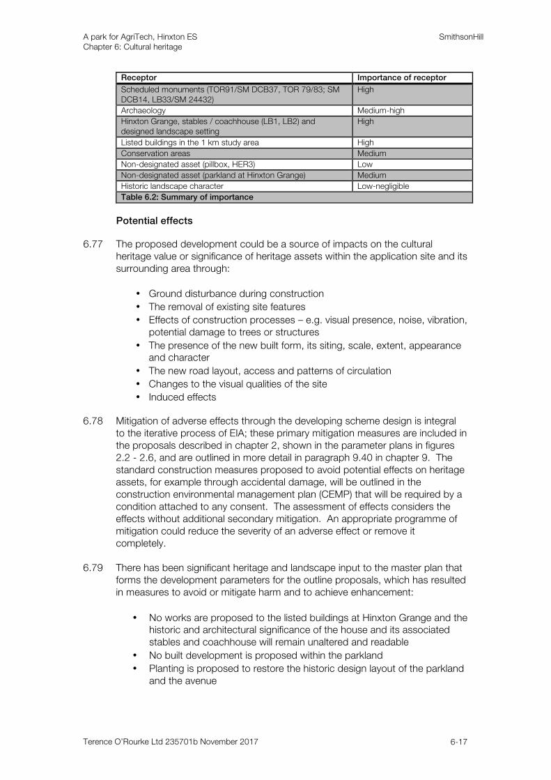
6.76 Table 6.2 summarises the importance of the heritage assets within the site and
study area.
A park for AgriTech, Hinxton ES SmithsonHill Chapter 6: Cultural heritage
Terence O’Rourke Ltd 235701b November 2017 6-17
Receptor Importance of receptor
Scheduled monuments (TOR91/SM DCB37, TOR 79/83; SM DCB14, LB33/SM 24432)
High
Archaeology Medium-high
Hinxton Grange, stables / coachhouse (LB1, LB2) and designed landscape setting
High
Listed buildings in the 1 km study area High
Conservation areas Medium
Non-designated asset (pillbox, HER3) Low
Non-designated asset (parkland at Hinxton Grange) Medium
Historic landscape character Low-negligible
Table 6.2: Summary of importance
Potential effects
6.77 The proposed development could be a source of impacts on the cultural heritage value or significance of heritage assets within the application site and its surrounding area through:
• Ground disturbance during construction
• The removal of existing site features
• Effects of construction processes – e.g. visual presence, noise, vibration, potential damage to trees or structures
• The presence of the new built form, its siting, scale, extent, appearance and character
• The new road layout, access and patterns of circulation
• Changes to the visual qualities of the site
• Induced effects 6.78 Mitigation of adverse effects through the developing scheme design is integral
to the iterative process of EIA; these primary mitigation measures are included in the proposals described in chapter 2, shown in the parameter plans in figures 2.2 - 2.6, and are outlined in more detail in paragraph 9.40 in chapter 9. The standard construction measures proposed to avoid potential effects on heritage assets, for example through accidental damage, will be outlined in the construction environmental management plan (CEMP) that will be required by a condition attached to any consent. The assessment of effects considers the effects without additional secondary mitigation. An appropriate programme of mitigation could reduce the severity of an adverse effect or remove it completely.
6.79 There has been significant heritage and landscape input to the master plan that
forms the development parameters for the outline proposals, which has resulted in measures to avoid or mitigate harm and to achieve enhancement:
• No works are proposed to the listed buildings at Hinxton Grange and the historic and architectural significance of the house and its associated stables and coachhouse will remain unaltered and readable
• No built development is proposed within the parkland
• Planting is proposed to restore the historic design layout of the parkland and the avenue
A park for AgriTech, Hinxton ES SmithsonHill Chapter 6: Cultural heritage
Terence O’Rourke Ltd 235701b November 2017 6-18
• Definitive infrastructure ratios including building heights and orientation are proposed close to the parkland edge to the south and west to break up the proposed massing
• A tree belt will be created along the southern edge of the parkland to ensure screening of development in certain views south from Hinxton Grange
• The hedgerow that forms the western site application boundary adjacent to the A1301 will be reinstated by new planting of breaks / gaps and a planted earth bund will be created to strengthen the boundary
6.80 The phasing of the 10-15 year construction of the proposed development would
commence in 2019 / 2020 and is outlined in chapter 2 and shown in figure 2.7.
Effects during construction
Archaeology
6.81 The proposed development will involve extensive groundworks, which will inevitably have an impact on all below ground archaeological remains where they are now known or suspected to exist. The risk of impacts from the proposed development would come from the possible damage to any unanticipated below ground features, such as former settlement sites or the identified remnants of burial monuments that would be disturbed by the construction process.
6.82 The non-designated archaeology within the boundary of the application site is
considered to be of medium-high importance, primarily due to the extent and survival of a multi-period landscape comprising evidence for settlement from at least the Middle Bronze Age and burial monuments of a similar age. A large physical change is predicted to occur as a result of the proposed development. The effects, without applying any form of mitigation, will therefore be substantial. This effect is classed as significant for the EIA.
Historic landscape and built heritage
6.83 The works proposed within the parkland at Hinxton Grange will take place as part of phase 1 of the development. These works will include the removal of individual trees and the creation of a number of breaks in the existing vegetation, one to allow an access point for a pedestrian / cycleway from the south boundary of the park, and three to allow similar routes across the avenue. The reinstatement of tree clumps in the parkland and replacement of some trees in the avenue will also take place as part of phase 1 of the development. This planting is based on the layout depicted on historic maps and the species present across the parkland, so avoids speculative interventions. No other works will be required to allow the proposed public use of the parkland and its character will not change.
6.84 Planting of native species woodland is proposed on the south and west
boundaries of the parkland. This will be planted in belts between 15 and 20 m wide and a mix of stock that will create a mixed age woodland with a range of species and heights. The historic and present layout of the park differentiates between the planting of the park boundaries, in the contrast of the thick belts of
A park for AgriTech, Hinxton ES SmithsonHill Chapter 6: Cultural heritage
Terence O’Rourke Ltd 235701b November 2017 6-19
woodland on the north and east sides with the more open south and west sides. The proposed mitigation planting is therefore a new feature and is contrary to the original design intentions, giving an impression of enclosure and reducing the open views across the wider countryside. Present views into the parkland from outside, from a number of breaks in the hedgerow adjacent to the A1301, will no longer be experienced because of the hedgerow enhancement planting and the earthwork bunding proposed along the western application site boundary. The axial view westwards from the principal elevation of the house will remain more open. The planting is proposed to mitigate visual effects of the development on the edge of the parkland, in particular to the south, but over time will itself create an enclosed and inward-looking character, to serve its future role as public open space for the adjacent development.
6.85 The felling of some trees for arboricultural reasons and the proposed parkland
restoration are minor works, reflecting the present intact layout and the good condition of the park. The designed landscape is a non-designated asset in its own right and the works to reinstate part of the historic layout of the parkland as it appears on maps up to the mid 20th century will be a small-medium change to an asset of medium importance, which is a slight-moderate beneficial effect that is significant. The resulting change to the contribution of the setting to the significance of the listed house will be a negligible change to an asset of high importance, which is a slight beneficial effect that is not significant.
6.86 The works to create breaks in some sections of the existing parkland planting,
and the introduction of the new boundary planting, altering the legible historic design intentions, will be a small-medium change to an asset of medium importance, which is a slight-moderate adverse effect that is significant. The resulting change to the contribution of the parkland setting to the significance of the listed house will be a negligible-small change to an asset of high importance, which is a slight-moderate adverse effect that is significant.
6.87 No works are proposed to the WWII pillbox (HER3). 6.88 The construction period is proposed to last for 10 to 15 years in four phases
(see figure 2.7), all of those phases including development on the margins of the parkland, and one phase involving construction along both sides of the avenue (see VP3, figure 9.15). The visible construction activity, and related noise and other disturbance, will therefore be a feature of the setting of the listed buildings for a long period, at different locations and intensity at different times. The attractiveness of the park and overall impression as an amenity expected of a house of this type, and the character of the views of and from the house, and within the designed landscape, and their contribution to the significance of the asset will therefore be changed during construction. The effects of the presence of construction activity within the setting of Hinxton Grange for a period of 10-15 years will be a small change to an asset of high importance, which is a temporary moderate adverse effect that is significant.
6.89 The construction activity is predicted to be visible from some areas on the
northern and eastern edge of Hinxton village, partially screened by vegetation and divided from the site by the barrier of the A1301 (see VP2, figure 9.14). This will be a minor visual change over a long period and will vary by phase. These areas include the open fields within the conservation area designation, a
A park for AgriTech, Hinxton ES SmithsonHill Chapter 6: Cultural heritage
Terence O’Rourke Ltd 235701b November 2017 6-20
footpath and part of the churchyard and the buildings on North End Road. There would be no views from the linear main street or the tight building groups that form the historic village core. The value of the setting to the significance of the asset is in the general rural character and the contrast with the buildings set on the linear High Street. The open land to the east allows the view of the village (the rear of houses, often with well vegetated boundaries) and the church from the realigned main road that had moved from the valley route by the early 17th century. The effect on the character and appearance of the conservation area of the visible construction activity within its rural setting is predicted to be a negligible-small change to asset of medium importance, which is a temporary slight adverse effect that is not significant.
6.90 The church (LB24) is the only individual heritage asset in Hinxton village for
which an extensive setting is of value because of the landmark function of the tower with its distinctive needle spire, which is visible on the edge of the village and in the wider area of farmland (including a section of the avenue at Hinxton Grange). Except for those areas of farmland within the site itself, the presence of construction will not impinge on these views. No change is predicted to the value of its setting to the significance of the church. The other listed buildings (LB3 - 23, 25) are set within the inward-looking linear village street. No change is predicted to the value of the setting of these listed buildings during construction.
6.91 The construction work for the bus / cycle interchange at Whittlesford will be on
the edge of the group that includes the Hospital of St John the Baptist (LB33, grade II* and SM 24432) and the Red Lion hotel (LB34), separated from it by the large railway station car park and areas of trees. This is a mixed area of modern development, strongly influenced by the A505 and the railway, and part of the value of the setting of the former chapel is to highlight the unexpectedness of its survival within this disparate group. The contribution of the setting of the listed buildings and scheduled monument to their significance will not be altered by the construction activity. No effects are predicted.
6.92 The other designated assets in the study area are the listed buildings and the
conservation area at Pampisford and the edge of the conservation area designations at Sawston and Duxford. These are historically separate villages, each within a different parish, and are unrelated to the site area. The assessment in chapter 9 has found that the visual changes during construction will be small (VPs1 and 6 and figures 9.13 and 9.18). No effects are predicted.
Effects post-construction
Archaeology
6.93 The nationally designated scheduled monuments in the study area are an extensive complex of cropmarks identified on the lower slope of a gravel ridge on the west side of the River Cam floodplain (TOR91/SM DCB37) and a 2.5 km north west to south east section of the Brent Ditch (TOR79/83; SM DCB14). The extent of the cropmarks is traceable from aerial photographs. The setting of this probable Roman settlement is the floodplain landscape to the west of the River Cam and the village of Hinxton and there are no visual or functional links between this monument and the application site that would give rise to any
A park for AgriTech, Hinxton ES SmithsonHill Chapter 6: Cultural heritage
Terence O’Rourke Ltd 235701b November 2017 6-21
appreciable change to its setting. The value of the setting of the scheduled monument to the significance of the asset is negligible and the application site does not contribute to the significance, with no functional, visual or historic relationships. No significant effects are predicted on this scheduled monument or its setting as a consequence of the proposed development.
6.94 The Brent Ditch is one of four Saxon Cambridgeshire defensive dyke
earthworks, with this section stretching from low ground on the eastern side of Pampisford up onto the high ground across the Icknield Way to the plateau in Great Abingdon. The setting is in part dominated by traffic on both the A505 and M11, with the majority of what is discernible of the bank and ditch set within a copse. The application site forms agricultural land in the wider setting of a portion of this historic territorial monument. The value of the setting of the scheduled monument to the significance of the asset is negligible and the application site does not contribute to the significance, with no functional, visual or historic relationships. No significant effects are predicted on this scheduled monument or its setting as a consequence of the proposed development.
Historic landscape and built heritage
6.95 The built form will consist of development of two storeys (9 m) to three storeys (13.5 m). As shown on the building heights and density parameter plans (figures 2.4 and 2.5), additional limits governing the proportions of built development and infrastructure (including parking areas) to landscape, and the orientation of buildings, are set for the development blocks immediately adjacent to the parkland edge at Hinxton Grange. These are divided into two zones: area A, which is proposed as at least 50% landscape, up to 25% building footprint and up to 25% infrastructure per hectare; and area B, which is proposed as at least 40% landscape, up to 40% infrastructure and up to 20% building footprint per hectare. Within these areas, the buildings will be a maximum of 60 m long and 22 m wide(6) and will be orientated so that the smaller elevation is presented to the adjacent parkland. No point features (such as air conditioning plant, which elsewhere across the site could be up to 5 m above the maximum building height) are proposed in this area.
6.96 While the conclusions of this section of the assessment are constrained by the
level of information outlined by the parameter plans in figures 2.2 - 2.6, the information given about density and building heights in figures 2.4 and 2.5 enables a reliable judgement to be made about the impacts of the development closest to the parkland on Hinxton Grange. Also, the section on Hinxton Grange in the design and access statement includes further illustrative material and an explanation of the design rationale. The relevant figures are the viewpoint photographs VPs 1, 3, 4 and 5 (figures 9.13 and 9.15-9.17).
6.97 The proposed built development falls within the designed landscape setting of
the listed buildings at Hinxton Grange (LB1, LB2). This consists of several components (as described in technical appendix D part 7) and is of high value to the significance of the assets. The designed landscape is also a non-designated asset in its own right.
6 For comparison, the principal western façade of the listed house is c.18 m wide.
A park for AgriTech, Hinxton ES SmithsonHill Chapter 6: Cultural heritage
Terence O’Rourke Ltd 235701b November 2017 6-22
6.98 The building group and the gardens close to the house are outside the application boundary and there are no proposals for change. The division between the parkland and this retained private space is the present garden boundary (see VP3, figure 9.15). No built development is proposed within the central square of the parkland, so there will be no effect on the integrity of this part of the designed landscape through physical change. A single new access point breaches the park boundary for the path to allow public access.
6.99 The proposed development will result in the following effects on the designed
landscape at Hinxton Grange:
• The loss of the open farmland that was the estate of the owner of the house, and the source of wealth and local importance displayed through the building of the new house and its landscape
• The loss of the open land to the south and west that allows the designed landscape to be understood as set within, but separate from, the surrounding agricultural land
• The presence of the built development (and the associated activity, vehicles, lighting etc.) along the park boundary to the south and west, within the axial designed view from the entrance front, and along and either side of the avenue, and at the transition to the enclosed parkland
• The loss of the views from the house of the wider area and of the ‘borrowed landscape’ beyond the park boundaries, and the loss of the reciprocal views of the house and parkland setting, especially as seen from the A1301, a short section of which adjacent to the site has a footpath, and the A505
6.100 The development will erode the qualities of the currently little altered setting of
the listed buildings at Hinxton Grange. The development will occupy the agricultural land that allows the parkland (with the avenue approach and the extension of the woodland up the hill to Round Plantation) to be read as a distinctive and separate area within the rural landscape. There will be particular change to several of the components that are important to the aesthetic qualities of the park, including the axial view from the entrance front and private views from principal rooms on the western façade, and the landmark role of the approach avenue. The avenue is no longer used to provide access to the house and there are no proposals to reinstate it.
6.101 The built development will become a significant characteristic of the setting as
experienced from a number of viewpoints within and outside the parkland and from the house itself. In more distant views, the house will no longer appear as a rural estate, but on the edge of a larger built area. The landscape planting provided as mitigation for other reasons is itself the source of additional effects, resulting over time in a more enclosed character. As assessed in chapter 9 (landscape and visual effects), 15 years after completion the new planting will have a significant effect in screening the visual effects of the development, but this will not alter the effects upon the original intended design and wider farmland setting of the house.
6.102 No works are proposed to the house, stables or coachhouse; or to the gardens,
and there will be no built development within the parkland. However, as a result of the development there will be a change to the value of the setting to the
A park for AgriTech, Hinxton ES SmithsonHill Chapter 6: Cultural heritage
Terence O’Rourke Ltd 235701b November 2017 6-23
house at Hinxton Grange and the related group, which will be a medium change to an asset of high value. This constitutes a substantial adverse effect that is significant. Effects on the designed landscape as a non-designated asset will be a medium-large change to an asset of medium value, which will be a moderate-substantial adverse effect that is significant.
6.103 No specific use is proposed for the WWII pillbox (HER3), which will be retained
in the landscape boundary planting. The pillbox is a small and isolated feature that contributes to local distinctiveness. The setting of open fields is of limited value to the significance of the structure, and there are no related features. The pillbox will be retained within an altered setting of the new park for AgriTech buildings. No effects are predicted on this non-designated asset.
6.104 The northern edge of Hinxton conservation area on North End Lane lies c.470 m
south west of the proposed built edge and there are open views across this part of the site from the edge of the village across the hedgerows either side of the A1301. The areas closest to the village will remain unchanged in agricultural use for crop trials. The site area is unrelated to the historic village centre focused on the High Street and the mills and meadows on the river valley, but is of value as part of the setting of the conservation area because of its historic association with the fields of the parish. The landscape of modern agriculture also contributes to the overall rural impression, despite the proximity of the large complex at the Wellcome Trust campus to the south, which appears separated from the village by the enclosed and wooded grounds of Hinxton Hall, which was itself set apart by the changes to create the parkland in the early 19th century.
6.105 The proposed development will change the character of a large area of currently
agricultural land, and the built development is predicted to be visible from some areas on the northern and eastern edge of the village, partially screened by vegetation, and divided from the site by the barrier of the A1301 and the retained area to be used for crop trials (VPs 2 and 4, figures 9.14 and 9.16). The effect on the character and appearance of the conservation area of the change to the rural setting will be a small-medium change to asset of medium importance, which will be a slight-moderate adverse effect that is significant.
6.106 The listed buildings in the village are houses of domestic scale or farm groups
set on the village street and the separate farm and mill complexes on the river to the west (LB3 - 23, 25). The value of their setting to the significance of these buildings is restricted and does not extend to include the application site. The exception is the church (LB24), which is located on the edge of the village and has an identifying and landmark role, in particular in views from the A1301 in which the tower with spire appears alongside the backs of houses and well-vegetated boundaries. The development will not impinge on these views, but the built development is predicted to be visible in areas around the church, c.780 m to the south west, and in glimpses on the A1301. The effect on the church of the visible built development within its wider rural setting is predicted to be a small change to asset of high importance, which is a moderate adverse effect that is significant.
6.107 The village of Pampisford (VP1, figure 9.13) serves a separate parish and there
are no historic or functional associations to the site area. The village is set back
A park for AgriTech, Hinxton ES SmithsonHill Chapter 6: Cultural heritage
Terence O’Rourke Ltd 235701b November 2017 6-24
from the main routes of the A1301 and the A505, and within well-vegetated boundaries. The listed buildings are concentrated in the dense linear development of the two main village streets and the conservation area designation is tightly drawn around this area. There will be no change to the value of the rural setting to these assets. No effects are predicted. Similarly, no effects are predicted on the conservation areas at Sawston and Duxford, small areas of which fall within the study area.
6.108 The new bus / cycle interchange and pedestrian / cycle / equestrian bridge are
separated from the historic buildings at Whittlesford Parkway station by the station car park and areas of trees. The value of the mixed and predominantly modern setting of the former Hospital of St John the Baptist (LB33, SM 24432) and the Red Lion hotel (LB34) to these assets is in its contrast to the visible timedepth of the medieval building and evidence of continuity. The bus / cycle interchange and bridge will appear as additions to the existing highways infrastructure and buildings at the roundabout and the visual change will not be significant. The contribution of the setting of the listed buildings and scheduled monument to their significance will not be altered by the new development. No effects are predicted.
6.109 The proposed development will occupy an area of large parliamentary enclosure
fields and add to the proportion of built development. There will be no change to the overall historic landscape character and no effects are predicted.
Mitigation
Archaeology
6.110 The predicted substantial effect on archaeology can be wholly mitigated through a programme of excavation. This would include, where feasible, schemes of community involvement, followed by dissemination to the local and wider archaeological community. Preservation by record, i.e. excavation, is a sufficient and policy-recognised form of mitigation that can adequately mitigate the predicted substantial effect.
6.111 It is widely recognised in government guidance and policy(7) that the historic
environment provides the basis for a community’s sense of place and connectivity with past communities that shaped the local landscape. Potential opportunities for community involvement and / or dissemination will have no impact on the development programme, as they are tasks that can be undertaken during the site investigation work, or during the post-excavation analysis.
6.112 Future marketing opportunities of the archaeological findings could be utilised in
local schools and / or in the placement of one or a number of heritage interpretation panel(s) that would display and describe the findings, similar to the examples now in place to the north east at Fourwentways Travelodge that illustrate the adjacent Bronze Age barrows that were investigated prior to construction. These measures can be outlined in a brief and specification for
7 NPPF (2012) paragraph 126 and Conservation Principles – policies and guidance for the sustainable
management of the historic environment (English Heritage, 2008), 13.
A park for AgriTech, Hinxton ES SmithsonHill Chapter 6: Cultural heritage
Terence O’Rourke Ltd 235701b November 2017 6-25
the recommended work by CHET, and implemented by the successful archaeological contractor.
6.113 While the very process of excavation can be viewed as destructive, it yields the
most reliable evidence and can lead to an expression of the past for those who live, or are planning to live, close to the site of discovery. The known archaeological resource would be destroyed through erosion, continued crop trials, dewatering processes and other varying levels of development infrastructure, and therefore excavation is justified as much data that would otherwise be lost will be recorded.
6.114 The application site has been divided into six zones based on the results of the
trench evaluation and the identified landscape organisation and / or areas of settlement (see figure 6.9). It is intended to excavate and preserve by record the definite archaeological areas / sites identified in the trench evaluation, namely: the series of Bronze Age ring ditches; Bronze Age enclosures near the western boundary; the Iron Age enclosure in the south east and the adjacent Iron Age settlement. While the trench evaluation successfully identified these areas of activity, it also revealed a central zone stretching from trenches 9 and 10 south of the avenue to Hinxton Grange to trench 69 in the south. It is not intended to undertake any further investigations in this zone, as it was found to be outside the areas of settlement between the Bronze and Iron Age due to unsuitable underlying geology.
6.115 Zone 1 on land west of the A1301 and north of the A505 was sufficiently
evaluated and probable areas of Iron Age and Roman settlement were identified in three of the four trenches. However, as the design evolved and the traffic and transport surveys were concluded, the application site boundary has been reduced to outside the settlement(s) identified above. The proposals for a bus / cycle interchange in this location will result in the creation of a dedicated bus stop and the necessary road infrastructure. Detailed proposals are not available, but future groundworks should be the subject of pre-commencement archaeological investigations.
6.116 Zone 2 lies immediately north of the avenue to Hinxton Grange. A second
phase of evaluation trenching (18no.) took place 11-22 September, as works had to be delayed to allow harvesting of crop trials(8). The intention was to evaluate the continuation and south west extent of what may be a formal track (A9 on figure 6.7) to the probable Roman villa (A7); as well as double ditch and headland features that extend south to zone 3 and the large former field boundary identified in the aerial photo assessment. No other aerial or geophysical anomalies were identified in this zone and the evaluation has shown that the lack of anomalies on the eastern portion of this zone demonstrates an absence of settlement related activity, which may be due to unfavourable geological conditions. The area should be the subject of targeted open area excavation, outside the areas of identified low / negligible archaeology (see figure 6.9), to determine the extent and date of the probable trackway anomaly and any other features that may survive but have thus far evaded detection.
8 This approach and the necessity of a second phase were endorsed by CHET, email correspondence 23
August 2017.
A park for AgriTech, Hinxton ES SmithsonHill Chapter 6: Cultural heritage
Terence O’Rourke Ltd 235701b November 2017 6-26
6.117 Zones 3 and 5 were found to contain well-defined areas of land organisation in the form of extensive boundaries dating from the Late Bronze Age / Early Iron Age; remnants of former Bronze Age burial barrows and a large rectilinear enclosure and contemporary Iron Age settlement area. All will require further, detailed full excavation and the surrounding landscape on the eastern part of zone 3 and western part of zone 5 should be the subject of strip, map and record to the identified edge of the change in geology in the central zone. There is a landscape and earthworks strategy for redistributing the topsoil arisings from the proposed development across zones 4 and 6 and to utilise within the earth bunding shown on the landscape and open space parameter plan (see figure 2.3). To facilitate future arable crop trials in zones 4 and 6, a maximum of 0.06 m of topsoil will be spread onto the existing ground level. The postulated southern extent of the Iron Age settlement is shown within the eastern extent of zone 6. This area should be fully excavated prior to topsoil being spread.
6.118 Depending on the significance and sensitivity of the site investigation work
locally, social media could be employed for dissemination of findings during and after the archaeological site investigations. A site-specific blog, Facebook page or Twitter account could be initiated if deemed appropriate by the client. With the open area excavations proposed, there may be the opportunity to promote this positive archaeological mitigation work. There could be open day events or dedicated tours for local schools, especially as archaeology is now part of the national curriculum, and finds from a local excavation would be seen as a preferred opportunity to disseminate the archaeological heritage to a wider, local audience than merely publishing results in peer reviewed academic journals. Information packs for occupiers of business units at the proposed development site could include a summary card / pamphlet to explain the finds and process involved as part of the construction phase.
6.119 A detailed written scheme of investigation will be produced by a suitably
qualified and approved archaeological contractor and fully endorsed by CHET following a specific brief. In the unlikely event that additional features of archaeological interest are uncovered during construction outside of investigation areas, further appropriate surveys and investigations will be undertaken. In the first instance, CHET will be informed and the methodology for appropriate archaeological investigations will be discussed and agreed. These investigations will fully mitigate the predicted substantial adverse effect, and will result in a substantial, significant beneficial effect through the knowledge gained as a consequence of the work.
Built heritage and historic landscape
6.120 The effects on the designed landscape and setting of the listed buildings at Hinxton Grange will occur as a result of the fundamental characteristics of the proposed development, its location and siting, and of its form and scale. The measures integrated into the master plan to avoid or mitigate potential effects are outlined in paragraph 6.79.
6.121 Secondary mitigation measures can reduce potential impacts. These would
come forward during detailed design at the reserved matters application stage and are summarised in the landscape and visual effects assessment, chapter 9, paragraphs 9.54 - 9.61, and explained in more detail in the design and access
A park for AgriTech, Hinxton ES SmithsonHill Chapter 6: Cultural heritage
Terence O’Rourke Ltd 235701b November 2017 6-27
statement. Although at this outline stage, and without detailed design, it is not possible to be certain of their implementation, such measures could reduce the element of visual change resulting from the proposed development at completion of each of the phases over the 10-15 year construction period, bearing in mind that the primary mitigation measures will be implemented in phase 1.
6.122 To ensure the future management of the parkland for its intended role as a
publicly accessible space adjacent to the proposed development, a management plan will be secured through a condition attached to any consent. This will prevent any induced effects resulting from possible divergence of management of the park and control the nature of the boundary between the house and garden and the rest of the parkland.
Residual effects
6.123 If archaeological finds are uncovered during development, the measures set out in the mitigation section will ensure that no significant adverse residual effects will result. Any agreed archaeological investigation at the site will be, by its very nature, a destructive process, but the benefit to the current body of knowledge for this site will be effectively filled through the material and artefact assemblage uncovered. The measures set out in the WSI and in line with best practice and the code of practice as set out by the Chartered Institute of Archaeologists, of which the author is a member, will ensure that the archaeological resource at the site will be properly safeguarded and suitably disseminated.
6.124 Table 6.3 summarises the significant residual effects predicted to remain after
the application of the secondary mitigation measures.
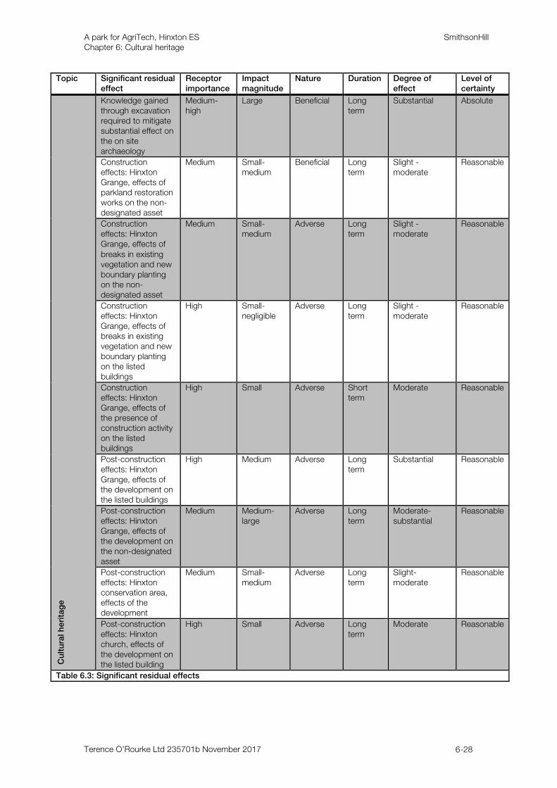
A park for AgriTech, Hinxton ES SmithsonHill Chapter 6: Cultural heritage
Terence O’Rourke Ltd 235701b November 2017 6-28
Topic Significant residual effect
Receptor importance
Impact magnitude
Nature Duration Degree of effect
Level of certainty
Cu
ltu
ral h
eri
tag
e
Knowledge gained through excavation required to mitigate substantial effect on the on site archaeology
Medium-high
Large Beneficial Long term
Substantial Absolute
Construction effects: Hinxton Grange, effects of parkland restoration works on the non-designated asset
Medium Small- medium
Beneficial Long term
Slight -moderate
Reasonable
Construction effects: Hinxton Grange, effects of breaks in existing vegetation and new boundary planting on the non-designated asset
Medium Small- medium
Adverse Long term
Slight -moderate
Reasonable
Construction effects: Hinxton Grange, effects of breaks in existing vegetation and new boundary planting on the listed buildings
High Small- negligible
Adverse Long term
Slight -moderate
Reasonable
Construction effects: Hinxton Grange, effects of the presence of construction activity on the listed buildings
High Small Adverse Short term
Moderate Reasonable
Post-construction effects: Hinxton Grange, effects of the development on the listed buildings
High Medium Adverse Long term
Substantial Reasonable
Post-construction effects: Hinxton Grange, effects of the development on the non-designated asset
Medium Medium-large
Adverse Long term
Moderate-substantial
Reasonable
Post-construction effects: Hinxton conservation area, effects of the development
Medium Small-medium
Adverse Long term
Slight-moderate
Reasonable
Post-construction effects: Hinxton church, effects of the development on the listed building
High Small Adverse Long term
Moderate Reasonable
Table 6.3: Significant residual effects
A park for AgriTech, Hinxton ES SmithsonHill Chapter 6: Cultural heritage
Terence O’Rourke Ltd 235701b November 2017 6-29
Cumulative effects 6.125 As set out in chapter 3, the potential for cumulative effects with a number of
consented and proposed developments in the area has also been assessed. 6.126 The proposal gives rise to a substantial, significant adverse effect to the known
and suspected archaeological resource within the site. However, adverse effects can be fully mitigated through the appropriate and agreed levels of evaluation and recording, as set out above. There is the potential for further adverse cumulative effects on the archaeological resource of the local area as a result of the other schemes in the area. A similar approach in terms of archaeological evaluation and preservation by record will be applied by CHET in order to inform and duly mitigate potential effects.
6.127 The wider landscape is known to be rich in early prehistoric settlements and
landscape organisation and further investigations will add to the known and suspected resource. Information on the archaeological resource of the other proposed developments is not known, except for the extensive prehistoric and Romano-British information gained from excavations at the Wellcome Trust Genome Campus. It is not therefore possible to accurately evaluate other potential impacts in combination with those within the application site. As excavation by its nature is a destructive process, there are potential effects of the eventual excavation of a large amount of land surrounding Hinxton, resulting in a large cumulative change on the below ground archaeological resource from all future development proposals, which will result in a substantial, significant cumulative effect. However, these works will add greatly to the existing archaeological knowledge of the area and result in substantial, significant beneficial cumulative effects.
6.128 An electricity connection is required from within the application site boundary to
Fulbourn sub-station to the north. Such work would be undertaken under licence and the proposed route alignment was chosen to follow the existing road verges to ensure impacts on the archaeological resource are kept to a minimum. No additional adverse impacts to those already considered are likely to occur as a consequence of the care taken to advise on the proposed connection route.
6.129 There are three wastewater treatment options being proposed, and discussions
are ongoing with Anglian Water and the Environment Agency to determine the final option chosen. A wastewater rising main from the application site to the existing wastewater pumping station at Duxford may be required, but only if the option of connecting to the existing public foul sewer network is chosen. Impacts on the archaeological resource would be kept to a minimum in such a scenario and no additional adverse impacts are likely to occur.
6.130 The only relevant scheme for the assessment of cumulative effects on built
heritage is the Wellcome Trust Genome Campus to the south of Hinxton village. The campus is long established, having its origins in the wartime use of Hinxton Hall. It is integrated into the mature landscape setting of the estate at Hinxton Hall and the landscape planting provided as part of the campus. The main buildings are more than 1 km away from the proposed development and share no historic or functional associations to the heritage assets affected by the
A park for AgriTech, Hinxton ES SmithsonHill Chapter 6: Cultural heritage
Terence O’Rourke Ltd 235701b November 2017 6-30
proposed development alone. There are therefore expected to be no significant cumulative effects with the Wellcome Trust development.
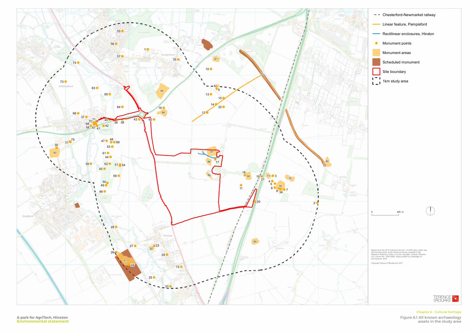
FOLD
FOLD
FOLD
FOLD
FOLD
FOLD
FOLD
FOLD
1
2
3
456 78
9
10
11
12
13
14
15
16
17
1819
20
21
22
23
24
25
26
27
28
29
3031
32
33
34
35
36
3738
39
40
4142
43
44
45
46
47 48
4950
51
5253
54
55
56
57
58
59
60
61
62
63
64
65
66
6768
69
7071
72
73
74
75
7677
78
7980
81
82
83
84
85
86
87
88
89 90
91
92
93
I
SmithsonHill
Drawn by:
JCChecked by:
JT
Based upon the 2016 Ordnance Survey 1:10,000 colour raster mapwith the permission of the Ordnance Survey on behalf of HerMajesty's Stationery Office, © Crown copyright. Terence O'RourkeLtd. Licence No. 100019980. Data provided by Cambridge CCand Hydrock, 2016
Copyright Terence O'Rourke Ltd, 2017
31 August 2017
Scale: 1:17,000 @A3
0 425 m
! ! ! ! Chesterford-Newmarket railway
Linear feature, Pampisford
Rectilinear enclosures, Hinxton
! Monument points
Monument areas
Scheduled monument
Site boundary
1km study area
LONDON
7 Heddon Street LondonW1B 4BD
BOURNEMOUTHEverdene House Deansleigh Road Bournemouth BH7 7DU
020 3664 6755 www.torltd.co.uk
Revision
Dwg no/
Figure 6.1: All known archaeology assets in the study area
Land at Hinxton
TELEPHONE
A park for AgriTech, HinxtonEnvironmental statement
Chapter 6 - Cultural heritage
Figure 6.1 All known archaeology assets in the study area
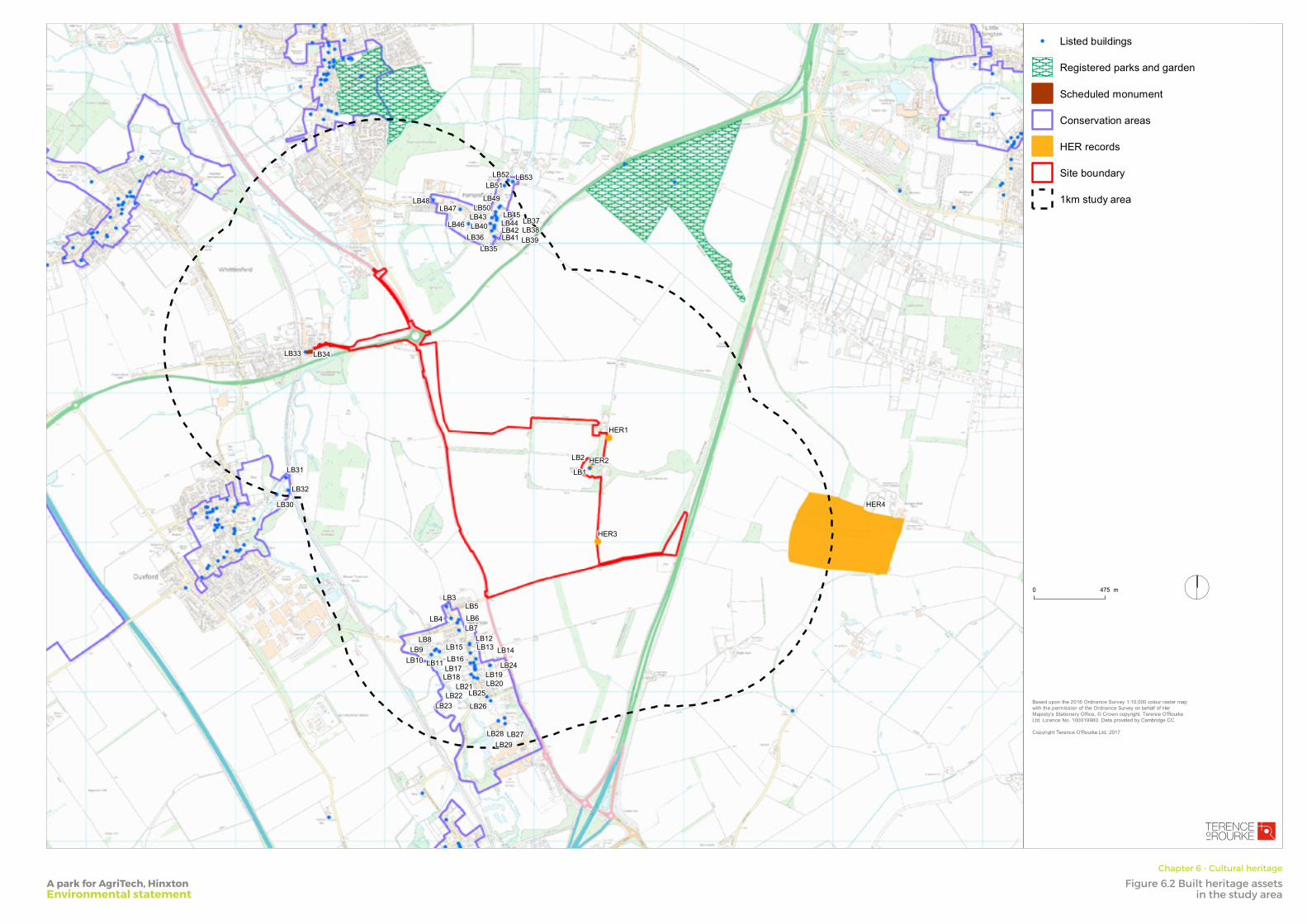
FOLD
FOLD
FOLD
FOLD
FOLD
FOLD
FOLD
FOLD
LB48
LB40 LB44LB38
LB35
LB2
LB18
LB29
LB17
LB4
LB22
LB16LB14LB13
LB5
LB11
LB8
LB34LB33
LB31
LB47LB49
LB39LB42
LB24
LB21
LB7
LB19
LB15LB12
LB6
LB9
LB20
LB45LB37LB46
LB10
LB25
LB26
LB28
LB1
LB27
LB23
LB3
LB36
LB50LB43
LB41
LB53LB51
LB52
LB30
LB32
HER4
HER2
HER1
HER3
I
Drawn by:
JCChecked by:
JT
Based upon the 2016 Ordnance Survey 1:10,000 colour raster mapwith the permission of the Ordnance Survey on behalf of HerMajesty's Stationery Office, © Crown copyright. Terence O'RourkeLtd. Licence No. 100019980. Data provided by Cambridge CC
Copyright Terence O'Rourke Ltd, 2017
31 August 2017
Scale: 1:20,000 @A3
0 475 m
! Listed buildings
Registered parks and garden
Scheduled monument
Conservation areas
HER records
Site boundary
1km study area
LONDON
7 Heddon Street LondonW1B 4BD
BOURNEMOUTHEverdene House Deansleigh Road Bournemouth BH7 7DU
020 3664 6755 www.torltd.co.uk
Revision
Dwg no/
Figure 6.2: Built heritage assets in the study area
Land at Hinxton
TELEPHONE
A park for AgriTech, HinxtonEnvironmental statement
Chapter 6 - Cultural heritage
Figure 6.2 Built heritage assets in the study area
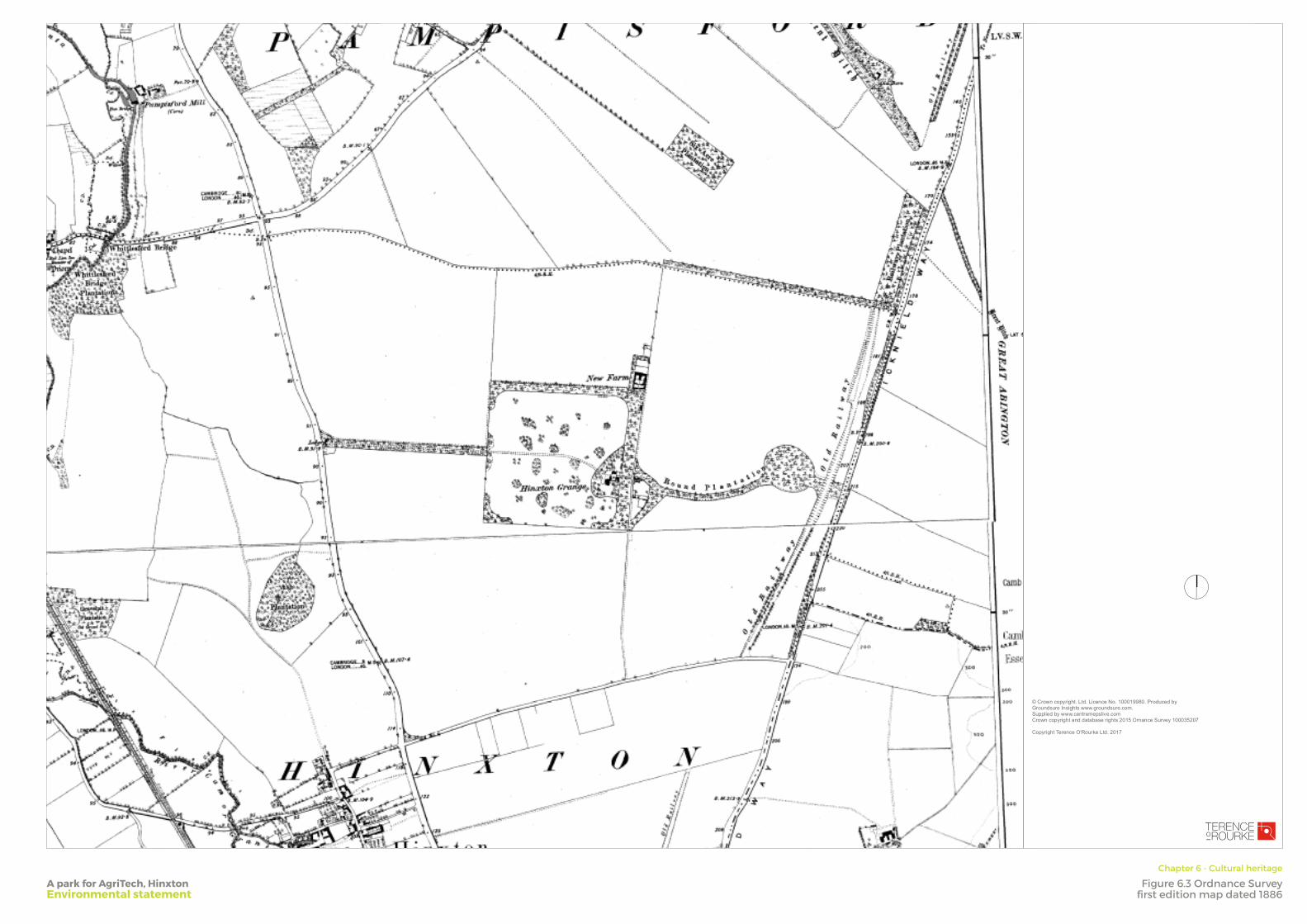
FOLD
FOLD
FOLD
FOLD
FOLD
FOLD
FOLD
FOLD
I
Drawn by:
JCChecked by:
JT
© Crown copyright. Ltd. Licence No. 100019980. Produced byGroundsure Insights www.groundsure.com. Supplied by www.centremepslive.comCrown copyright and database rights 2015 Ornance Survey 100035207
Copyright Terence O'Rourke Ltd, 2017
08 May 2017
LONDONLinen Hall 162-168 Regent StLondon W1B 5TE
BOURNEMOUTHEverdene House Deansleigh Road Bournemouth BH7 7DU
020 3664 6755 www.torltd.co.uk
Revision
Dwg no/
Figure 6.3: Ordnance Survey first edition map dated 1886
Land at Hinxton
TELEPHONE
A park for AgriTech, HinxtonEnvironmental statement
Chapter 6 - Cultural heritage
Figure 6.3 Ordnance Survey first edition map dated 1886
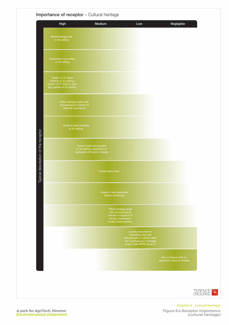
Importance of receptor – Cultural heritage
Typi
cal d
escr
iptio
n of
the
rec
epto
r
High LowMedium Negligible
World heritage site or its setting
Scheduled monument or its setting
Grade I or II* listed building or its setting,
grade I or II* historic park and garden or its setting
Other heritage asset with archaeological interest of
national importance
Grade II listed building or its setting
Grade II park and garden or its setting, shipwreck or
battlefield of historic interest
Other heritage asset with archaeological
interest of regional or county importance,
locally listed building
Locally important or interesting site with
educational or cultural value not qualifying as a heritage asset under NPPF Annex 2
Site or feature with no significant value or interest
Conservation area
Areas of well preserved historic landscape
A park for AgriTech, HinxtonEnvironmental statement
Chapter 6 - Cultural heritage
Figure 6.4 Receptor importance(cultural heritage)
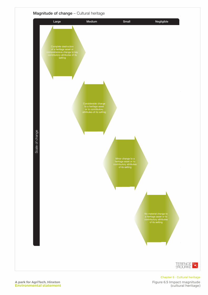
Magnitude of change – Cultural heritage
Sca
le o
f cha
nge
NegligibleMedium SmallLarge
Complete destruction of a heritage asset or
comprehensive change to key contributory attributes of its
setting
Considerable change to a heritage asset or to contributory
attributes of its setting
Minor change to a heritage asset or to
contributory attributes of its setting
No material change to a heritage asset or to contributory attributes
of its setting
A park for AgriTech, HinxtonEnvironmental statement
Chapter 6 - Cultural heritage
Figure 6.5 Impact magnitude(cultural heritage)
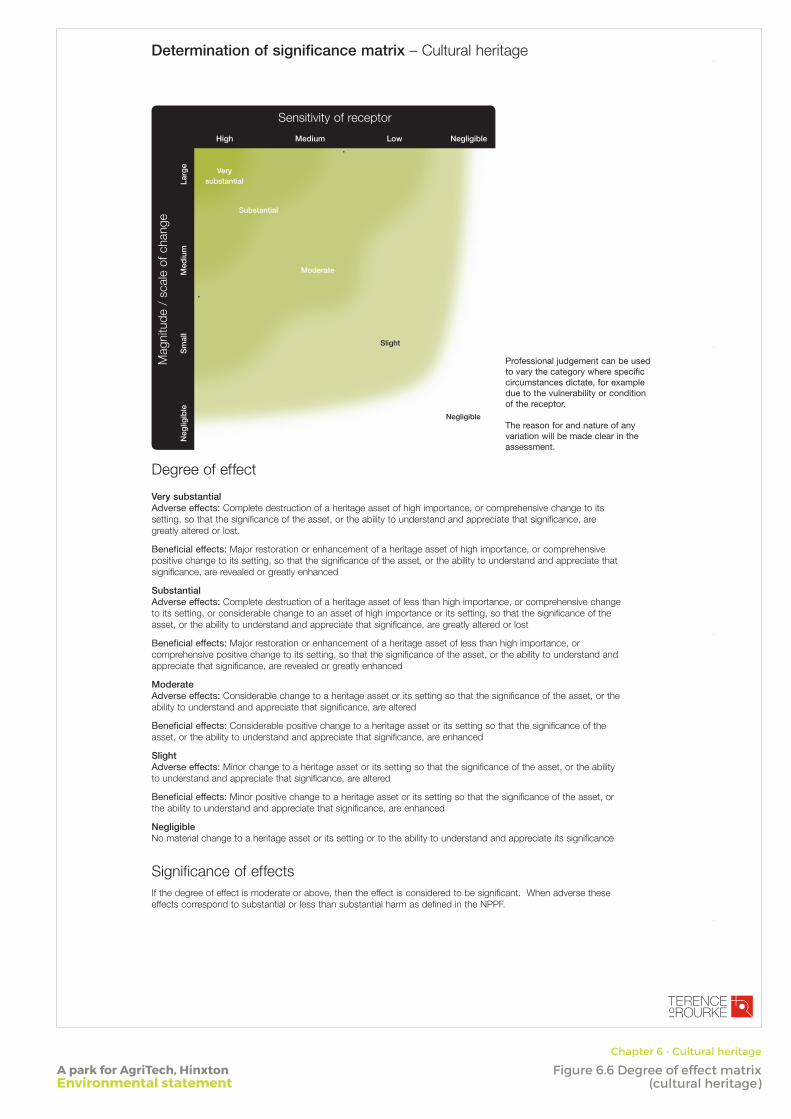
Determination of significance matrix – Cultural heritage
Mag
nitu
de /
sca
le o
f cha
nge
Larg
eM
ediu
mS
mal
lN
eglig
ible
High Medium NegligibleLow
Sensitivity of receptor
Slight
Negligible
Moderate
Substantial
Very substantial
Degree of effect Very substantial Adverse effects: Complete destruction of a heritage asset of high importance, or comprehensive change to its setting, so that the significance of the asset, or the ability to understand and appreciate that significance, are greatly altered or lost.
Beneficial effects: Major restoration or enhancement of a heritage asset of high importance, or comprehensive positive change to its setting, so that the significance of the asset, or the ability to understand and appreciate that significance, are revealed or greatly enhanced
Substantial Adverse effects: Complete destruction of a heritage asset of less than high importance, or comprehensive change to its setting, or considerable change to an asset of high importance or its setting, so that the significance of the asset, or the ability to understand and appreciate that significance, are greatly altered or lost
Beneficial effects: Major restoration or enhancement of a heritage asset of less than high importance, or comprehensive positive change to its setting, so that the significance of the asset, or the ability to understand and appreciate that significance, are revealed or greatly enhanced
Moderate Adverse effects: Considerable change to a heritage asset or its setting so that the significance of the asset, or the ability to understand and appreciate that significance, are altered
Beneficial effects: Considerable positive change to a heritage asset or its setting so that the significance of the asset, or the ability to understand and appreciate that significance, are enhanced
Slight Adverse effects: Minor change to a heritage asset or its setting so that the significance of the asset, or the ability to understand and appreciate that significance, are altered
Beneficial effects: Minor positive change to a heritage asset or its setting so that the significance of the asset, or the ability to understand and appreciate that significance, are enhanced
Negligible No material change to a heritage asset or its setting or to the ability to understand and appreciate its significance
Significance of effectsIf the degree of effect is moderate or above, then the effect is considered to be significant. When adverse these effects correspond to substantial or less than substantial harm as defined in the NPPF.
Professional judgement can be used to vary the category where specific circumstances dictate, for example due to the vulnerability or condition of the receptor.
The reason for and nature of any variation will be made clear in the assessment.
A park for AgriTech, HinxtonEnvironmental statement
Chapter 6 - Cultural heritage
Figure 6.6 Degree of effect matrix (cultural heritage)
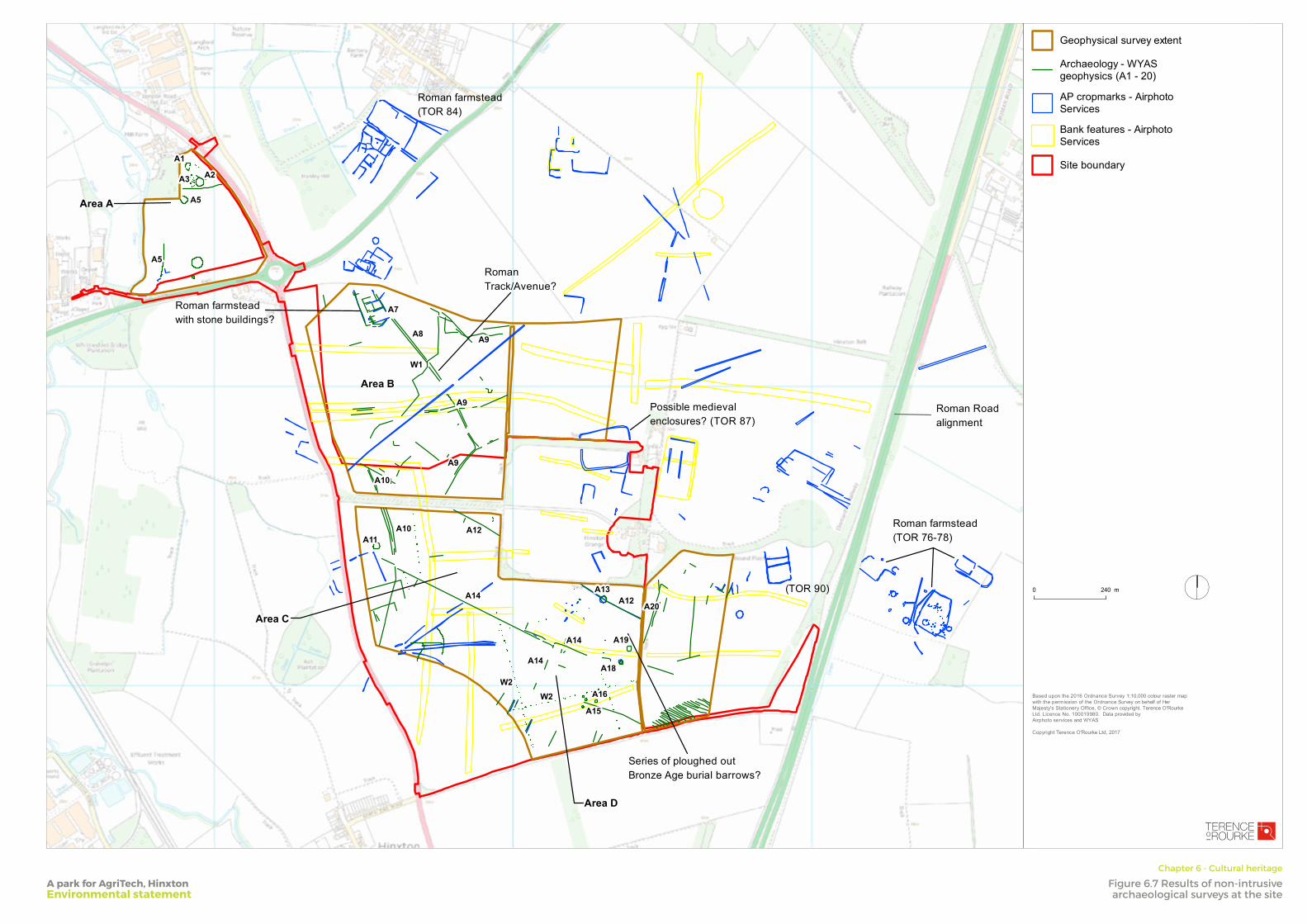
FOLD
FOLD
FOLD
FOLD
FOLD
FOLD
FOLD
FOLD
Roman farmstead(TOR 84)
Roman Track/Avenue?
Roman farmstead with stone buildings?
Possible medieval enclosures? (TOR 87)
Roman Roadalignment
Roman farmstead(TOR 76-78)
Series of ploughed out Bronze Age burial barrows?
(TOR 90)
Area A
Area B
Area C
Area D
A19
A3
A9
A15
A16
A14
A1
A18
A5
A13
A11
A2
A10
A20
A5
A14
A12
A7
A10
A9A8
A12
A9
A14
W2W2
W1
I
SmithsonHill
Drawn by:
JCChecked by:
JT
Based upon the 2016 Ordnance Survey 1:10,000 colour raster mapwith the permission of the Ordnance Survey on behalf of HerMajesty's Stationery Office, © Crown copyright. Terence O'RourkeLtd. Licence No. 100019980. Data provided by Airphoto services and WYAS
Copyright Terence O'Rourke Ltd, 2017
31 August 2017
Scale: 1:10,000 @A3
0 240 m
Geophysical survey extent
Archaeology - WYASgeophysics (A1 - 20)
AP cropmarks - AirphotoServices
Bank features - AirphotoServices
Site boundary
LONDON
7 Heddon Street LondonW1B 4BD
BOURNEMOUTHEverdene House Deansleigh Road Bournemouth BH7 7DU
020 3664 6755 www.torltd.co.uk
Revision
Dwg no/
Figure 6.7: Results of non-intrusive archaeological surveys at the site
Hinxton
TELEPHONE
A park for AgriTech, HinxtonEnvironmental statement
Chapter 6 - Cultural heritage
Figure 6.7 Results of non-intrusive archaeological surveys at the site
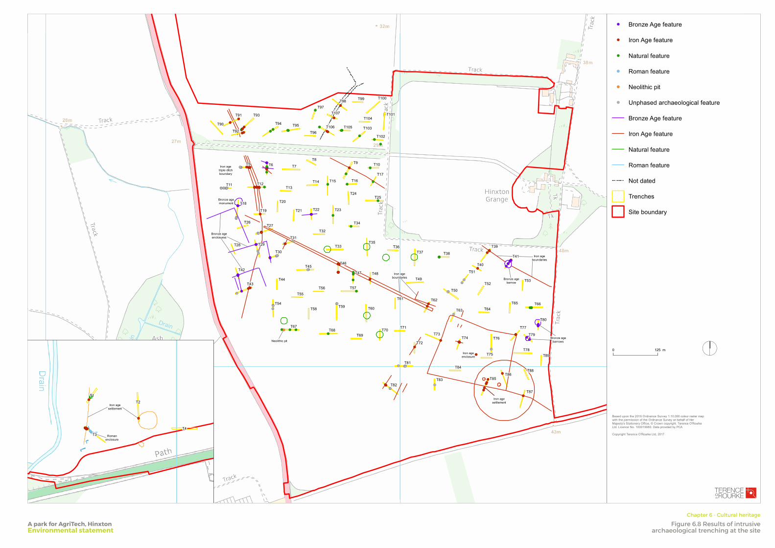
FOLD
FOLD
FOLD
FOLD
FOLD
FOLD
FOLD
FOLD
!(
!(
!(
!(
!(
!(
!(
!(
!(!(
!(
!(!(!(
!(
!(
!(!(!(
!(!(
!(
!(!(
!(
!(
!(
!(
!(
!(!(
!(!(!(
!(
!(
!(!(
!(!(
!(
!(!(
!(
!(
!(!(
!(!(!(
!(
!(!(
!(
!(
!(
!(
!(
!(!( !( !(
!(!(
!(!(
!(!(!(!(
!(
!(
!(
!(
!(
!(
!(
!(
!(
!(
!(!(
!(!(!(!(
!(
!(!(!(!(!(!( !(
!( !(!(!(!(
!(!( !(!(!(
!(!(
!(!(
!( !(!(
!(!(
!(!(
!(!(
!(!(
!(
!(
!(
!(
!(
!(
!(!(
!(!(!(!(
!(!(!(!(!(
!(!(
!(!(!(!(
!(
!( !(!(!(
!(
!(
!(!(
!(
!(
!(
!(!(!(!(!(
!(!(!(
!(
!(!(
!(
!(
!(!(!(!( !(!(
T90
T92
T94 T95
T96
T97T98 T99 T100
T101
T102
T103
T104
T105T106
T107T93T91
Iron ageenclosure
Bronze agebarrow
Iron agesettlement
Neolithic pit
Iron ageboundaries
Bronze agemonument
Iron agetriple ditchboundary
Bronze ageenclosures
Bronze agebarrows
Iron ageboundaries
T78
T88T86
T77
T79T73
T83
T89
T87
T80
T66T65T64
T53T52
T40
T39
T51
T82
T81
T72
T38T37T36
T49
T61 T62
T70T69
T60
T57
T47 T48
T35T33
T46
T59
T68T67
T58
T56T55
T54
T43
T42
T28 T29
T30
T44
T45
T26T27
T31
T32
T23
T24
T16
T34
T25
T17
T10T9
T15T14
T8
T7
T13
T6
T12
T5
T11
T18
T19
T20
T21 T22
T71
T75
T85
T84
T74 T76
T50
T63
T41
I
SmithsonHill
Drawn by:
JCChecked by:
JT
Based upon the 2016 Ordnance Survey 1:10,000 colour raster mapwith the permission of the Ordnance Survey on behalf of HerMajesty's Stationery Office, © Crown copyright. Terence O'RourkeLtd. Licence No. 100019980. Data provided by PCA
Copyright Terence O'Rourke Ltd, 2017
29 September 2017
Scale: 1:5,000 @A3
0 125 m
!( Bronze Age feature
!( Iron Age feature
!( Natural feature
!( Roman feature
!( Neolithic pit
!( Unphased archaeological feature
Bronze Age feature
Iron Age feature
Natural feature
Roman feature
Not dated
Trenches
Site boundary
LONDON
7 Heddon Street LondonW1B 4BD
BOURNEMOUTHEverdene House Deansleigh Road Bournemouth BH7 7DU
020 3664 6755 www.torltd.co.uk
Revision
Dwg no/
Figure 6.8: Results of intrusive archaeological trenching at the site (after PCA 2017)
Land at Hinxton
TELEPHONE
!(!(!(!(!(!(!(
!(
!(
!(
!(!(
Romanenclosure
Iron agesettlement
T4
T2
T3
T1
A park for AgriTech, HinxtonEnvironmental statement
Chapter 6 - Cultural heritage
Figure 6.8 Results of intrusive archaeological trenching at the site

FOLD
FOLD
FOLD
FOLD
FOLD
FOLD
FOLD
FOLD
!(
!(
!(
!(
!(
!(
!(
!(
!(!(
!(
!(!(!(
!(
!(
!(!(!(
!(!(
!(
!(!(
!(
!(
!(
!(
!(
!(!(
!(!(!(
!(
!(
!(!(
!(!(
!(
!(!(
!(
!(
!(!(
!(!(!(
!(
!(!(
!(
!(
!(
!(
!(
!(!( !( !(
!(!(
!(!(
!(!(!(!(
!(
!(
!(
!(
!(
!(
!(
!(
!(
!(
!(!(
!(!(!(!(
!(
!(!(!(!(!(!( !(
!( !(!(!(!(
!(!( !(!(!(
!(!(
!(!(
!( !(!(
!(!(
!(!(
!(!(
!(!(
!(
!(
!(
!(
!(
!(
!(!(
!(!(!(!(
!(!(!(!(!(
!(!(
!(!(!(!(
!(
!( !(!(!(
!(
!(
!(!(
!(
!(
!(
!(!(!(!(!(
!(!(!(
!(
!(!(
!(
!(
!(!(!(!( !(!(
Zone 3
Zone 5
Zone 6Zone 4
Zone 2
T90
T92
T94 T95
T96
T97T98 T99 T100
T101
T102
T103
T104
T105T106
T107T93T91
Iron ageenclosure
Bronze agebarrow
Iron agesettlement
Neolithic pit
Iron ageboundaries
Bronze agemonument
Iron agetriple ditchboundary
Bronze ageenclosures
Bronze agebarrows
Iron ageboundaries
T78
T88T86
T77
T79T73
T83
T89
T87
T80
T66T65T64
T53T52
T40
T39
T51
T82
T81
T72
T38T37T36
T49
T61 T62
T70T69
T60
T57
T47 T48
T35T33
T46
T59
T68T67
T58
T56T55
T54
T43
T42
T28 T29
T30
T44
T45
T26T27
T31
T32
T23
T24
T16
T34
T25
T17
T10T9
T15T14
T8
T7
T13
T6
T12
T5
T11
T18
T19
T20
T21 T22
T71
T75
T85
T84
T74 T76
T50
T63
T41
I
SmithsonHill
Drawn by:
JCChecked by:
JT
Based upon the 2016 Ordnance Survey 1:10,000 colour raster mapwith the permission of the Ordnance Survey on behalf of HerMajesty's Stationery Office, © Crown copyright. Terence O'RourkeLtd. Licence No. 100019980. Data provided by PCA
Copyright Terence O'Rourke Ltd, 2017
29 September 2017
Scale: 1:5,000 @A3
0 125 m
Site boundary
!( Bronze Age feature
!( Iron Age feature
!( Natural feature
!( Roman feature
!( Neolithic pit
!( Unphased archaeological feature
Bronze Age feature
Iron Age feature
Natural feature
Roman feature
Not dated
Trenches
Area of low archaeologysignificance
Known archaeology undisturbedby proposals (zone 1)
Built development proposal
Primary movement corridor
LONDON
7 Heddon Street LondonW1B 4BD
BOURNEMOUTHEverdene House Deansleigh Road Bournemouth BH7 7DU
020 3664 6755 www.torltd.co.uk
Revision
Dwg no/
Figure 6.9: Zones of archaeological mitigation in relation to parameterplan proposals
Land at Hinxton
TELEPHONE
!(!(!(!(!(!(!(
!(
!(
!(
!(!(
Zone 1
Romanenclosure
Iron agesettlement
T4
T2
T3
T1
A park for AgriTech, HinxtonEnvironmental statement
Chapter 6 - Cultural heritage
Figure 6.9 Zones of archaeological mitigation in relation to master plan proposals