Embed Size (px)
Citation preview
CGSIC/IISC - National Report of Germany
K. Pahler, G. Weber
CGSIC/IISC 9th European Meeting, Monaco, 30 Nov – 1 Dec, 2000
Fundamental Survey
With its Satellite Positioning Service SAPOS, Germany provides a uniform system for the benefit of both privatecustomers and state survey administrations. SAPOS is being regarded as essential contribution to the basicprovisions for existence by the state and as an appropriate measure for enhancing the infrastructure provided bythe state survey administrations. The extensive offer of DGPS-data, covering different levels of accuracy anddifferent media for communication is realising the consistent step towards a modern, multi-functional provisionof geodetic spatial reference. However, the development has not yet been finalised. The standardised applicationof the European reference system (EUREF), providing the uniform geodetic reference, remains desirable andimportant for the future.
The Satellite Positioning Service of the German State Survey
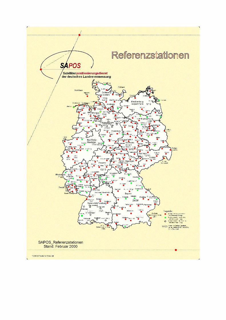
An area-covering net of GPS-reference stations (SAPOS) is being established in Germany to provide differentialGPS-data in standardised, producer-independent formats. It is putting into effect the geodetic reference systemETRS 89.
The EPS (Real-time Positioning Service) offers an accuracy of ca. 0.5 to 3 meters, correction data is broadcast inreal-time. In co-operation with German Telecom, the BKG offers the ALF-service (Accurate Positioning by LowFrequency). In addition, the service RASANT (Radio Aided Satellite Navigation Technique), is available viaVHP-transmitters area-covering for Germany. The correction data is broadcast using the RDS (Radio DataSystem) of the public VHF-radio transmitters.
The HEPS (High Precision Real-time Positioning Service) offers accuracies of 1 to 5 cm and requires a networkof GPS-reference stations in distances of ca. 50 km. Correction data are broadcast via own 2m-band VHF-transmitters or can be accessed via mobile telephone. The network of reference stations is being reinforced; atpresent 71% of all planned reference stations are working. In different states the reference stations are linkedonline to erase systematic influences of e.g. ionosphere or troposphere and thus allow an accuracy of position ofca. 2 cm at maximum reliability.
For the service GPPS (Geodetic Precision Positioning Service) with an accuracy of ca. 1 cm the signals of thereference stations must be recorded. They are made available to customers for post-processing or the “near-online-method" via Internet or telephone in the RINEX format.
In 1999 the Technical Committee SAPOS was founded. Delegates of AdV are now working together withproviders of GPS-hardware, software and communication technologies for improvement of common standardsand further development of services.
Since 1998 an annual SAPOS symposium regularly takes place. The last symposium, which was hosted inMunich in May 2000, assembled more than 300 participants from 12 different countries, and clearlydemonstrated the interest of national and international experts in DGPS services.
Federal Tasks in Fundamental Surveying
The Federal Office for Cartography and Geodesy (BKG) is focussing on the connection of the geodetichorizontal, vertical and gravity reference systems to European and global reference systems. A major con-tribution to this task has been made by the fundamental station Wettzell, which has heavily been involved in anumber of recent international surveying and evaluation campaigns applying spatial surveying methods. Since1999 the BKG has been pro-actively working with IVS (International Very Long Baseline Interferometry -VLBI-Service) by providing a data and analysis centre. BKG also takes part in ILRS (International LaserRanging Service). Further, the task of maintenance of the IERS (International Earth Rotation Service) centraloffice was assigned to the BKG. This service, which will start its operational activities in 2001, encompasses
documentation, distribution and archiving of the results of IERS and the combination of the results of all spatialgeodetic methods. BKG is running a regional GPS-data and analysis centre for Europe, which serves as:
• IGS data centre for Europe• Data centre for EUREF permanent stations• Data centre for the permanent stations of the German Reference-Net GREF• GLONASS data centre.
The results of altogether 12 national European computer centres are collected and combined here. BKG isrunning a network of 20 permanent GPS stations all over Germany (GREF); it also provides the nationalinformation - and observation system GIBS on the Internet.
The EU-project UNIGRACE will determine a uniform gravity reference system for 12 countries of Central andEastern Europe and fix the transformation parameters needed for the national gravity systems.
References
The following list contains publications regarding application and research work on geodetic reference systemsand services published since January 1999.
Adam, J.; Augath, W.; Boucher, C.; Bruyninx, C.; Dunkley, P.; Gubler, E.; Gurtner, W.; Hornik, H.; v.d. Marel, H.;Schlüter, W.; Seeger, H.; Vermeer, M.; Zielinski, J.B.: The European Reference System Coming of Age,In: Proceedings of the IAG General Assembly, Birmingham, July 18-30, 1999, In: IAG Symposia,Vol. 121, Geodesy Beyond 2000, Springer-Verlag, Berlin Heidelberg 2000, S. 47-54.
Adam, J.; Augath, W.; Brouwer, F.; Engelhardt, G.; Gurtner, W.; Harsson, B.G.; Ihde, J.; Ineichen, D.; Lang, H.;Luthardt, J.; Sacher, M.; Schlüter, W.; Springer, T.; Wöppelmann, G.: Status and Development of theEuropean Height Systems, In: Proceedings of the IAG General Assembly, Birmingham, July 18-30,1999, In: IAG Symposia, Vol. 121, Geodesy Begon 2000, Springer-Verlag, Berlin Heidelberg 2000,S. 55-60.
Altiner, Y., Becker, M., Dzonov, D., Postolovski, V., Seeger, H., Todosov, A.: The Results of the EUREF-FYROM-1996 GPS Campaign, in EUREF Publication No. 7/1, Mitteilungen des Bundesamtes für Kartographie undGeodäsie, Band 6, Frankfurt/Main, 1999, pp 79-88.
Altiner, Y., Colic, K., Marjanovic, M., Medic, Z., Medved, M., Miskovic, D., Piribicevic, B., Raisc, L., Seeger, H.,Szabo, M.: Is the Adria a Promontory or Exists as an Independent Mikroplate ?, Proceedings of the FifthInternational Seminar ,,GPS in Central Europe,, , 5-7 May 1999, Penc/Budapest, Reports on Geodesy,Warsaw University of Technology, No. 5(46), 1999, pp 143-149.
Altiner, Y., Ayan, T., Deniz, R., Celik, R N., Ergün, M., Kahveci, M., Lenk, O., Ocak, M., Salk, M., Seeger, H.,Türkezer, A.: GPS Measurements in Turkey from 1990 to 1997, Proceedings of the Third Turkish-German Joint Geodetic Days, Istanbul, 1 - 4 June, 1999.
Altiner, Y.: Analytical Surface Deformation Theory for the Detection of the Earth’s Crust Movements, Springer-Verlag, Heidelberg, 1999.
Altiner, Y., Schlüter, W., Seeger H.: Results of the BALKAN'98 GPS Campaigns in Albania, Bosnia andHerzegovina, and Yugoslavia, In: Gubler E., Torres A. J., Hornik H. (Editor): International Associationof Geodesy / Section I - Positioning; Subcommission for Europe (EUREF), Publication No. 8: Reporton the Symposium of the IAG Subcommission for Europe (EUREF) held in Prague, 2 - 5 June 1999 /Reports of the EUREF Technical Working Group. Bayerische Kommission für die InternationaleErdmessung, Nr. 60, München 1999.
Ambrosius, B. A. C., Noomen, R., Angermann, D., Wilson, P., Becker, M., Reinhart, E., Walpersdorf, A., Vigny,C.: Plate Motions in South East Asia: results of the GEODYSSEA Project. Geophys. Res. Letters: 26,2081-2084, 1999.
Angermann, D.; M. Becker: Untersuchungen zu Genauigkeit und systematischen Effekten in großräumigen GPSNetzen am Beispiel von GEODYSSEA, ZfV, No. 3, 2000.
Bayerisches Landesvermessungsamt (Editor): Vorträge des 3. SAPOS-Symposiums, 23. - 24. Mai 2000,München 2000.
Becker, M., P. Franke und G. Weber: Die Geodätischen GPS Referenznetze GREF und EUREF-Permanent. In3. DFG Rundgespräch zum Thema Bezugssysteme. M. Schneider (Editor), Mitteilungen desBundesamtes für Kartographie und Geodäsie, Band 5, 140-153, Frankfurt, 1999.
Becker, M., Ghitau, D., Marcu, C., Radulescu, F., Reinhart, E., Rosca, V., Rus, T., Seeger, H.: German andRomanian Activities in the CERGOP, Technical Report, Mitteilungen des Bundesamtes fürKartographie und Geodäsie, Band 12, 5-64, Frankfurt, 1999.
Becker, M.; G. Berrino, A.G. Camacho, R. Falk, O. Francis, C. Gagnon, C. Gerstenecker, J. Liard, G. Läufer,B. Meurers, F.-J. Navarro, I. Nowak, F. Rehren, U. Riccardi, B. Richter, M. van Ruymbeke, K.Schmidt, M. Schnüll, D. Stizza, J.E. Friederich, P. Vauterin, H. Wilmes: Results of Relative GravimeterMeasurements at the ICAG97 Intercomparison. Accepted by Bull d’Inf. BGI, No. 85, Toulouse, Dec.1999.
Becker, M. E. Reinhart, Soeb Bin Nordin, D. Angermann, G. W. Michel, Ch. Reigber: Improving the VelocityField in South and South-East Asia: The Third Round of GEODYSSEA, Submitted to Earth, Planetsand Space, Spec. Issue, Tokyo, 2000.
Becker, M., E. Reinhart, Chakorn Boonphakdee, Sanong Mingsamon und Samad Abu: Realisation des ITRS inThailand und Malaysia durch ein kombiniertes Netz für Geokinematik und Landesvermessung. ZfV,No. 3, 2000.
Becker, M., Angermann, D., Nordin, S., Reigber, CH., Reinhart, E.: Das Geschwindigkeitsfeld in Südostasienaus einer kombinierten GPS Lösung der drei GEODYSSEA Kampagnen von 1994 bis 1998, ZfV No 3,2000.
Becker M., S. Zerbini, T. Baker, B. Bürki, J. Galanis, J. Garate, I. Georgiev, H. Kahle, V. Kotzev, V. Lobazov, I.Marson, M. Negusini, B. Richter, G. Veis, P. Yuzefovich (2000): Assessment of Height Variations byGPS at Mediterranean and Black Sea Coast Tide Gauges from the SELF Project. Submitted to Globaland Planetary Change, Elsevier.
Crossley D., J. Hinderer, G. Casula, O. Francis, H.-T. Hsu, Y. Imanishi, G. Jentzsch, J. Kaarianen, J. Merriam,B. Meurers, J. Neumeyer, B. Richter, K. Shibuya, T. Sato, T. van Dam: Network of superconductinggravimeters benefits a number of disciplines, Trans. Am. Geophys. U., 80, 1999, 121-126.
Denker, H., Torge, W., Wenzel, G., Ihde, J., Schirmer, U.: Investigation of Different Methods for theCombination of Gravity and GPS/Levelling Data. In: Proceedings of the IAG General Assembly,Birmingham, July 18-30, 1999, In: IAG Symposia, Vol. 121, Geodesy 2000, Springer, BerlinHeidelberg 2000, S. 137-142.
Dick, W.R.; Mareyen, M.; Meinig, M.; Oppitz, K.; Richter, B.: SSC(BKG) 98 L 01 [Abstract]. In: C. Boucher, Z.Altamimi, P. Sillar: The International Terrestrial Reference Frame (ITRF97). (IERS Technical Note 27)Paris: Central Bureau of IERS - Observatoire de Paris, 1999, p. 20.
Dick, W., M. Mareyen, M. Meinig, K. Oppitz, B. Richter: The consistency of the global SLR Network.Proc. 11th
Int. Workshop on Laser Ranging, Deggendorf 1998, Mittlg. d. BKG, Band 10, Volume 1, 1999, 41-49.Dietrich, R., Dach, R., Engelhardt, G., Ihde, J., Korth, W., Kutterer, H.-J., Lindner, K., Mayer, M., Menge, F.,
Miller, H., Müller, C., Niemeier, W., Perlt, J., Pohl, M., Salbach, H., Schenke, H.-W., Schöne, T.,Seeber, G., Veit, A., Völksen, C.: ITRF coordinates and plate velocities from repeated GPS campaigns inAntarctica - an analysis based on different individual solutions. In Vorbereitung.
Habrich,H.: Kombinierte Auswerteverfahren für GLONASS und GPS. in: GPS-Praxis und Trends’97, DVWSchriftenreihe 35, 1999, 24-34.
Habrich H.: IGEX Analysis at BKG, Proceedings of the IGEX-98 Workshop, Nashville, Tennessee, September13-14, 1999.
Habrich H.: BKG’s Operation of GPS/GLONASS Receivers and Its Regional IGEX Data Center, Proceedingsof the IGEX-98 Workshop, Nashville, Tennessee, September 13-14, 1999.
Habrich H., Beutler G., Gurtner W., Rothacher M.: Double Difference Ambiguity Resolution forGLONASS/GPS Carrier Phase, Proceedings of the 12th International Technical Meeting, ION GPS-99,Nashville, Tennessee, September 14-17, 1999.
Habrich H.: BKG Regional IGS Data Center Report 1999, IGS 1999 Technical Reports, IGS Central Bureau,JPL, Pasadena California.
Habrich H.: Geodetic Applications of the Global Navigation Satellite System (GLONASS) and ofGLONASS/GPS Combinations, Dissertation Universität Bern, Switzerland, 1999, published in“Mitteilungen des Bundesamtes für Kartographie und Geodäsie, Band 15, ISBN 3-88648-099-2,Frankfurt / M. Germany, 2000.
Harnisch, M., Harnisch, G.:Hydrological Influences in the Registrations of Superconducting Gravimeters andWays to their Elimination. Marées Terrestres, Bull. Inf., Bruxelles 131 (1999), pp. 10161 – 10170.
Harnisch, M., Harnisch, G., Nowak, I., Richter, B., Wolf, P.: The Dual Sphere Superconducting GravimeterC029 at Frankfurt Main and Wettzell. First Results and Calibration. Proc. Second GGP Workshop,Munsbach 24-26 March 1999, im Druck
Harnisch, M., Harnisch, G., Jurczyk, H., Wilmes, H.: 889 Days of Registrations with the SuperconductingGravimeter SG103 at Wettzell (Germany). Proc. Second GGP Workshop, Munsbach 24-26 March1999, im Druck.
Harnisch, M., Harnisch, G., Nowak, I., Richter, B., Wolf, P.: The Dual Sphere Superconducting GravimeterGWR CD029 at Frankfurt Main and Wettzell. First Results and Calibration. IAG Symposia, Vol. 121,Springer-Verlag Berlin Heidelberg 2000, 155-160.
Hase, H.: Globale Bezugssysteme und TIGO, DFG Rundgespräch "Bezugssysteme", Höllenstein, 30. April1998, Mitteilung des BKG, Band 5, 1999.
Hase, H.; Schlüter, W.; Böer, A.: TIGO and its future application for the ITRF, Proceedings of the InternationalWorkshop on Geodetic Measurements by the collocation of Space Techniques on Earth (GEMSTONE)January 25-28, 1999, Koganei, Tokyo/Japan.
Hase, H.; Petrov, L.: The First Campaign of Observations with the VLBI-Module of TIGO, Proceedings of the 13th
Working Meeting on European VLBI for Geodesy and Astrometry, held at Viechtach, February 12-13,1999, edited by W. Schlüter and H. Hase, Bundesamt für Kartographie und Geodäsie, Wettzell, 1999.
Hase, H.: Phase Centre Determinations at GPS-Satellites with VLBI, Proceedings of the 13th Working Meeting onEuropean VLBI for Geodesy and Astrometry, held at Viechtach, February 12-13, 1999, edited by W.Schlüter and H. Hase, Bundesamt für Kartographie und Geodäsie, Wettzell, 1999.
Hase, H.: Transportable Integrated Geodetic Observatory, IVS Annual Report 1999, S. 110-115, NASA/TP-1999-209243, Sept. 1999.
Hase H.: Theorie und Praxis globaler Bezugssysteme, Disseration, Mittlgn. d. BKG, Band 13, Frankfurt / M. 1999.Hase, H.; Böer, A.; Riepl, S.; Schlüter, W.: Transportable Integrated Geodetic Observatory (TIGO), IVS-GM-
Proceedings, Kötzting, Febr. 2000.Ihde, J., Nothnagel, A., Reinhold, A., Soltau, G., Thorandt, V.: Der Beitrag der VLBI zum Internationalen
Erdrotationsdienst - eine wichtige Voraussetzung für die Realisierung globaler Bezugssysteme. In:Mitteilungen des Bundesamtes für Kartographie und Geodäsie, Band 5, Frankfurt a. M. 1999, S. 134 -139.
Ihde, J., Adam, J., Gurtner, W., Harsson, B. G., Schlüter, W., Wöppelmann, G.: The Concept of the EuropeanVertical GPS Reference Network (EUVN). EUREF-Symposium Bad Neuenahr-Ahrweiler, 10.-12. Juni1998. In: Mitteilungen des Bundesamtes für Kartographie und Geodäsie, Band 7, Frankfurt a. M. 1999,S. 23 - 46.
Ihde, J., Adam, J., Gurtner, W., Harsson, B. G., Schlüter, W., Wöppelmann, G.: The EUVN Project - FirstResults. In: Reports of the Finnish Geodetic Institute, 99:4, Kirkkonummi, Finland 1999, S. 177 - 182.
Ihde, J. u. a.: Der Beitrag des European Vertical Reference Network (EUVN) zu einem einheitlicheneuropäischen Höhensystem. In: Schriftenreihe des DVW, Nr. 35/1999, Wittwer 1999, S. 120 - 137.
Ihde, J., Schirmer, U.: Das Geoid im Zeitalter der Satellitennavigation. In: Schriftenreihe des DVW, Nr.35/1999, Wittwer 1999, S. 138 - 142.
Ihde, J., Adam, J., Gurtner, W., Harsson, B. G., Schlüter, W., Wöppelmann, G.: Status Report of the EUVNProject. Proceedings EUREF-Symposium Prag, 2.-4. Juni 1999, BEK Veröffentlichungen, Astr.-Geod.Arbeiten, Heft Nr. 60, 1999.
LINDSTROT, W. (Editor): Das Deutsche Referenznetz 1991 DREF 91. Mitteilungen des Bundesamtes fürKartographie und Geodäsie Band 9, Frankfurt 1999.
Michel, G., D. Angermann, M. Becker, P. Wilson: Seismische Deformation und Krustenextrusion: Interpretationder GEODYSSEA GPS-Lösungen. ZfV, No. 3, 2000.
Michel, G.W., M. Becker, D. Angermann, C. Reigber, E. Reinhart, and the GEODYSSEA-Team (2000): Newevidence for crustal motion in E and SE-Asia from GPS measurements. Submitted to Earth, Planets andSpace, Spec. Issue, Tokyo, 2000.
Nothnagel, A., V. Thorandt, L. Petrov: "The GIUB/BKG VLBI Analysis Center". In: International VLBI Servicefor Geodesy and Astrometry, Annual Report 1999.
Richter, B.: Tidal and others temporal variations of the gravity field, In: National Report of the Federal Republicof Germany on the geodetic activities in the years 1995-1999, DGK, Reihe B, 308, 1999, 106-110.
Richter B, H. Wilmes, A. Lothhammer, R. Falk, K. Colic, B. Pribicevic: Absolute gravity measurements inCroatia – a standardised base-net for geodynamic, height and gravity studies, Int. Symp. Geodynamicsof the Alps-Adria area by means of terrestial and satellite methods (2; 1998: Dubrovnik) Proc. 2nd int.Symp. Geodynamics of the Alps-Adria area by means of terrestial and satellite methods, Dubrovnik,Croatia, Sept. 28.-oct.2. 1998 / edited by Colic, K. and Moritz, H., University of Zagreb, faculty ofGeodesy, Zagreb, Graz 1999, pp. 263-270.
Riepl, S.: Lasermessungen nach Erdsatelliten auf zwei Wellenlängen unter Verwendung einer Streak-Kamera,Deutsche Geodätische Kommission bei der Bayerischen Akademie der Wissenschaften, Reihe C:Dissertation, Heft Nr. 495.
Riepl, S.; Schlüter, W.; Schreiber, U.: Evaluation of an SLR Adaptive Optics System, Remote Sensing, 20-24 Sept.1999, Florence/Italy, Proceedings of SPIE.
Sacher, M., Lang, H., Ihde, J.: Status and Results of the Adjustment and Enlargement of the United EuropeanLevelling Network 1995 (UELN-95). EUREF-Symposium Bad Neuenahr-Ahrweiler, 10.-12. Juni 1998.In: Mitteilungen des Bundesamtes für Kartographie und Geodäsie, Band 6, Frankfurt a. M. 1999, S. 131- 141.
Sacher, M., H., Ihde, Seeger, H.: Preliminary transformation relations between national European height systemsand the United European Levelling Network (UELN). Proceedings EUREF-Symposium Prag, 2.-4. Juni1999, BEK Veröffentlichungen, Astr.-Geod. Arbeiten, Heft Nr. 60, 1999.
Schlüter W.: The International VLBI Service for Geodesy and Astrometry (IVS): Chairmans's Report, AR-IVS,1999.
Schlüter, W.; Dassing, R.; Kilger, R.; Schreiber, U.: The Fundamental Station Wettzell -current status and futureplans-, Proceedings of GEMSTONE, Koganei, Tokio, January 25-28, 1999.
Schlüter, W.; Hase, H.; Röttcher, K.; Stöger, R.; Lang, H.; Zernecke, R.: Actual Results of the Local Survey at theFS-Wettzell, Proceedings of GEMSTONE, Koganei, Tokio, January 25-28, 1999.
Schlüter, W.; Hase, H.; Böer, A.: TIGO - a geodetic observatory for the improvement of the global reference frame,Proceedings EUROPTO, EOS/SPI Symposium on Remote Sensing, Florence, 20-24 Sept. 1999.
Schlüter, W.; Pahler, K.: Permanent GPS Networks and Realtime Positioning, In: National Report of the FederalRepublic of Germany on the geodetic activities in the years 1995-1999, DGK, Reihe B, 308, 1999.
Schlüter, W.; Reinhart, E.; Pahler, K.H.: Positioning for Global and Long Range Applications, In: National Reportof the Federal Republic of Germany on the geodetic activities in the years 1995-1999, DGK, Reihe B,308, 1999.
Schlüter, W., Adam, J., Gurtner, W., Harsson, B. G., Ihde, J., Wöppelmann, G.: Report of the EUVN WorkingGroup. Vorgelegt auf dem EUREF-Symposium in Bad Neuenahr-Ahrweiler, 10.-12. Juni 1998. In:Mitteilungen des Bundesamtes für Kartographie und Geodäsie, Band 7, Frankfurt a. M. 1999, S. 11 -22.
Schlüter W.: The International VLBI Service for Geodesy and Astrometry (IVS): Chairmans's Report, AR-IVS,NASA/TP 1999 – 209243.
Schreiber, U.; Kawano, N.; Yoshino, T.; Degnan, J.; Nordtvedt, K.; Müller, J.; Schlüter, W.; Kunimori, H.: LaserRanging and VLBI for the Selene-II Mission, Proceedings of the International Workshop on GeodeticMeasurements by the collocation of Space Techniques on Earth (GEMSTONE) January 25-28, 1999,Koganei, Tokyo/Japan.
Schreiber, U.; Schneider, M.; Rowe, C.H.; Stedman, G.E., Schlüter, W.: Stabilising the Operation of a Large RingLaser, Symposium Gyro Technology, 14./15.09.1999, Stuttgart, Germany, Proceedings of the Symposiumon Gyro Technology, Stuttgart 1999, Seite 14.0-14.10
Schreiber, U.; Schneider, M.; Stedman, G.E.; Rowe, C.H.; Schlüter, W.: Der C-II Ringlaser als Prototyp einesRotationssensors für geowissenschaftliche Anwendungen, DFG-Rundgespräch Bezugssysteme, Mitteilungdes BKG, Band 5, 1999.
Schreiber, U.; Schneider, M.; Rowe, C.H.; Stedman, G.E.; Schlüter, W.; Seeger, H.: Characteristics of a Ring Laserfor Geodesy, 11th International Workshop on Laser Ranging, Mitteilung des BKG, Band 10 und Band 11.
Schreiber, U.; Haufe, K.H.; Prochazka, I.: Concept of a Pet4/LabView-Control System, Proceedings of the 11th
Workshop on Laser Ranging, 413-420, 1999.Schreiber, U.; Haufe, K.H.: Timewalk in Avalanche Photo Diodes, Proceedings of the 11th Workshop on Laser
Ranging, 413-420, 1999.Schreiber, U.; Schlicht, A.; Haufe, K.H.: Systematic Biases in Laser Ranging Measurements, Symposium on
Satellite Remote Sensing, 20.-24. Sept. 99, Florence, Italy, Proceedings of the SPIE, Vol. 3865, Seite 64-73Schreiber, U.; Schneider, M.; Stedman, G.; Schlüter, W.: Characteristics of a Ring Laser for Geodesy, Proceedings of
the 13th Workshop Meeting on European VLBI, 278-284, 1999.Seeger, H., Altiner, Y.: Stand und Perspektiven von EUREF. In: Gerd Riedl und Hermann Seeger (Eds.): GPS-Praxis
und Trends, DVW Schriftenreihe 35/1999, Wittwer Verlag, pp 238-250.Simon, D., Harwardt, H.: Validierungsverfahren für Prognoserechnungen zur Standsicherheit der
Grubengebäude von Endlagern chem./tox. Abfälle durch Verwendung eines Arrays vonhochauflösenden Strainmetern, Forschungszentrum Karlsruhe, Wissenschaftliche Berichte. FZKA-PTENr. 1, S. 265-281.
Strakhov V.N., U.Schäfer, A.V.Strakhov: Neue lineare Approximationen linearer Elemente des Gravitationsfeldesder Erde - Probleme und Perspektiven. in: Freeden (Editor): Progress in Geodetic Science, Shaker,Aachen, S.315-322.
Strakhov V.N., U.Schäfer, A.V.Strakhov: New Linear Approximation of the Gravitational Field of the Earth. (inruss.) in: Basic Problems of the Theory of Interpretation of Gravimetric and Magnetic Anomalies(russ.), Moscow, 1999, p. 126-167.
Strakhov V.N., U.Schäfer, A.V.Strakhov: SNAP Models of the Regional Gravitational Field in Central Europe.in: Basic Problems of the Theory of Interpretation of Gravimetric and Magnetic Anomalies (russ.),Moscow, 1999, p. 168-182.
Strakhov V.N., U.Schäfer, A.V.Strakhov: New linear approximations of elements of the Earth’s gravitational fieldin global and regional variants. (in russ.) Proceedings of the Conference „Geophysics andMathematics“, Moskau, 22-26.11.1999, p.212-222.

Strakhov V.N., U.Schäfer, A.V.Strakhov: New high-resolution analytical approximations of the gravitational fieldin Europe derived by the SNAP method. (in russ.) Proceedings of the Conference „Geophysics andMathematics“, Moskau, 22-26.11.1999, p.222-223.
Strakhov V.N., U.Schäfer, A.V.Strakhov: Improved analytical approximations of the Earth’s gravitational field.in: Schwarz (ed.): Geodesy Beyond 2000 - The Challenges of the First Decade. IAG Symposia, vol.121, Springer-Verlag, Berlin Heidelberg, pp. 196-201.
Thorandt, V.: "BKG Data Center". In: International VLBI Service for Geodesy and Astrometry, IERS AnnualReport 1999.
Torge W., R. Falk, A. Franke, E. Reinhart, B. Richter, M. Sommer, H. Wilmes: Das Deutsche Schweregrundnetz1994 (DSGN94) – Band I -. DKG, Reihe B, Nr. 309, München, 1999.
Weber, G: Geodätisches GPS-Referenznetz GREF: Realisierung eines globalen terrestrischen Bezugssystems.Proceedings DFG-Rundgespräch „Bezugssysteme“, 22.-30. April 1998, Höllenstein, Bayerischer Wald,Mitteilung des BKG, Band 5, 1999.
Weber, G.: Das EUREF-Permanent GPS Array. In: Schriftenreihe des DVW, Nr. 35/1999, Wittwer 1999, S.251- 265.


![[12] WAAS-LAAS-CGSIC-07](https://img.pdfslide.us/doc/110x75/577d2ab61a28ab4e1ea9e232/12-waas-laas-cgsic-07.jpg)


![Pahler Ch19[8e] Temporal Method (1)](https://img.pdfslide.us/doc/110x75/5571ff7e49795991699d6263/pahler-ch198e-temporal-method-1.jpg)