Embed Size (px)
Citation preview

CERTIFIED SURVEY MAPS
http://doa.wi.gov/platreview January 2016 17-1
s. 236.34 (1) (am), Wis. Stats s. 236.03 (1), Wis. Stats s. 236.34 (1), Wis. Stats
PERMITTED USES A Certified Survey Map (CSM), consisting of 4 or less parcels of land designated as lots or outlots, may be recorded in the register of deeds office of the county in which the land is located. Such a CSM may be used to:
• Divide land for sale or exchange. • Create lots for building or other development. • Clarify metes and bounds descriptions. • Reconfigure parcels within a recorded subdivision plat,
assessor’s plat, or CSM. • Add land to an existing subdivision, assessor’s plat, or CSM
parcel. • Consolidate parcels in adjoining subdivisions, assessor’s
plats, or CSM’s. • Define and convey interest in lands dedicated to the public.
No map or survey creating divisions of land or intending to clarify metes and bounds descriptions may be recorded except as provided by Chapter 236, Wis. Stats. Local land division ordinance may mandate the use of a CSM for any or all of the above purposes, unless such use results in a subdivision as defined in s. 236.02 (12), and except as prohibited by s. 236.45 (2), Wis. Stats. Local land division ordinance may allow for the use of a CSM to create more than 4 lots or outlots in certain instances (see s. 236.34 (1) (ar), later in this section). A CSM may not alter areas previously dedicated to the public, unless such areas are properly vacated or discontinued pursuant to Ch. 236, subchapter VIII or s. 66.1003, Wis. Stats. A CSM may not alter restrictions, easements, covenants, or other encumbrances placed on the land by any manner, unless said restrictions, easements, covenants, or other encumbrances are released by the party having the right of enforcement, pursuant to s. 236.293 Wis. Stats.

CERTIFIED SURVEY MAPS s. 236.34 (1), Wis. Stats s. 236.34 (1), Wis. Stats
PERMITTED USES Reconfiguring lots A CSM may be used to reconfigure no more than 4 lots or outlots within a recorded subdivision, assessor’s plat, or CSM, provided that the reconfiguration:
• Does not result in a subdivision as defined by s. 236.02 (12);
• Creates parcels that comply with local ordinances, Ch. 236, Wis. Stats. minimum layout requirements, DOT requirements, and, if served with private sewerage facilities, ch. SPS 383 & 385, Wis. Admin. Code;
• Does not change areas previously dedicated to the public; or
• Does not change a restriction or easement placed on the platted land.
Crossing Subdivision boundaries A Certified Survey Map may cross the exterior boundary of a recorded subdivision plat, assessor's plat, or CSM with the following limitations:
• 4 parcels or less within a subdivision may be combined with platted or unplatted lands adjacent to the subdivision, by a single owner.
• No additional parcels may be created. • The CSM must include executed Owner's Certificates
from all parties of interest, and Mortgagees' Certificates if applicable.
• The CSM must be approved by all approving authorities in the same manner as a subdivision plat.
• The CSM must be monumented the same as a subdivision plat, (i.e. larger monuments at exterior and block corners.)
• The CSM may not change areas previously dedicated to the public.
• The CSM may not change restrictions or easements placed on the platted land.
http://doa.wi.gov/platreview December 2014 17-2

CERTIFIED SURVEY MAPS Example of Certified Survey Map combining parcels from two recorded subdivision plats.
http://doa.wi.gov/platreview December 2014 17-3

CERTIFIED SURVEY MAPS Example of Certified Survey Map combining parcels from a recorded subdivision
plat with unplatted lands.
http://doa.wi.gov/platreview December 2014 17-4
CERTIFIED SURVEY MAPS s. 236.34 (1m) (e), Wis. Stats. s. 236.45, Wis. Stats. s. 236.34 (1m) (f), Wis. Stats.
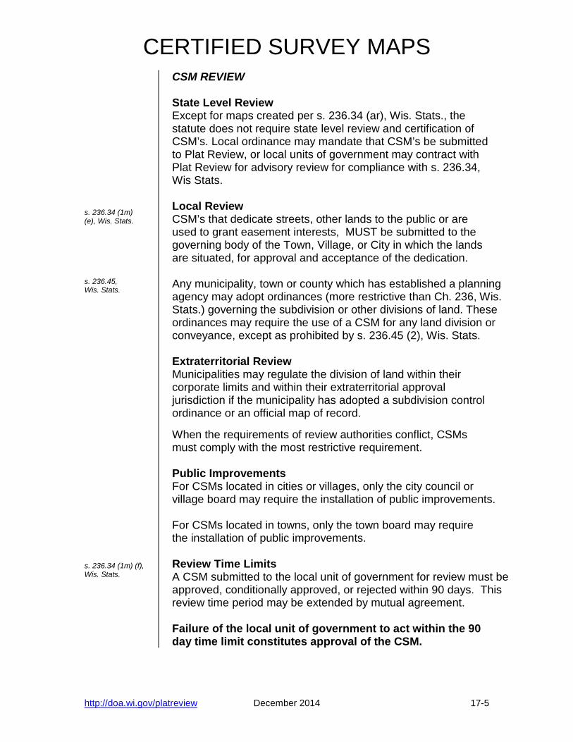
CSM REVIEW State Level Review Except for maps created per s. 236.34 (ar), Wis. Stats., the statute does not require state level review and certification of CSM’s. Local ordinance may mandate that CSM’s be submitted to Plat Review, or local units of government may contract with Plat Review for advisory review for compliance with s. 236.34, Wis Stats. Local Review CSM’s that dedicate streets, other lands to the public or are used to grant easement interests, MUST be submitted to the governing body of the Town, Village, or City in which the lands are situated, for approval and acceptance of the dedication. Any municipality, town or county which has established a planning agency may adopt ordinances (more restrictive than Ch. 236, Wis. Stats.) governing the subdivision or other divisions of land. These ordinances may require the use of a CSM for any land division or conveyance, except as prohibited by s. 236.45 (2), Wis. Stats. Extraterritorial Review Municipalities may regulate the division of land within their corporate limits and within their extraterritorial approval jurisdiction if the municipality has adopted a subdivision control ordinance or an official map of record. When the requirements of review authorities conflict, CSMs must comply with the most restrictive requirement. Public Improvements For CSMs located in cities or villages, only the city council or village board may require the installation of public improvements. For CSMs located in towns, only the town board may require the installation of public improvements. Review Time Limits A CSM submitted to the local unit of government for review must be approved, conditionally approved, or rejected within 90 days. This review time period may be extended by mutual agreement. Failure of the local unit of government to act within the 90 day time limit constitutes approval of the CSM.
http://doa.wi.gov/platreview December 2014 17-5

CERTIFIED SURVEY MAPS
http://doa.wi.gov/platreview January 2016 17-6
s. 236.34 (1m) (a), Wis. Stats. s. 236.15 (1) (ac), Wis. Stats.
SURVEY REQUIREMENTS Preparation of CSM’s The survey must be performed and the map prepared by or under the direction of a Wisconsin Professional Land Surveyor (as defined in Ch. A-E (2).) The land surveyor responsible for the survey and map must sign, seal and date each sheet of the CSM. Accuracy of Survey The ratio of error in the latitude and departure closure of the survey (or any part of the survey) must not exceed 1'/3000'. Monumentation Monuments must be set, flush with the ground if possible, at all lot, outlot and public dedication corners. This includes all angle points along a parcel boundary, at each end of a curve, all meander corners, and at the intersection of a lot line with a meander line. When corners fall within a street or proposed street, the monuments shall be placed in the sideline of the street when practical. Meander corner monuments are set back 20' or more from the top of bank or ordinary high water mark, as measured at a right angle to the shoreline (shortest distance). This shortest distance is shown on the map. Existing monuments that are archival and accepted as correct should not be removed and reset even if they do not comply with the standards of s.236.15 (1), Wis. Stats. They are noted as "existing" or "found" and described by type, diameter, and shape. Minimum Monument Requirements: Length: 18" Weight: 1.13 lbs./lin.ft Examples:
• 1" O.D. x 18" iron pipe. • 3/4" x 24" iron bar (or rebar). • Other types of iron or steel stakes that exceed the
minimum requirements.

CERTIFIED SURVEY MAPS
http://doa.wi.gov/platreview January 2016 17-7
s. 236.34 (1m) (c), Wis. Stats. s. 236.20 (2) (b), Wis. Stats.
MAPPING REQUIREMENTS Layout Not more than 4 parcels (lots and outlots) may be shown on the map (except for maps created under s. 236.34 (1) (ar)). Standard requirements for all sheets of a CSM:
• The recordable document is 8 1/2"x14" sheets of durable white media with nonfading black image.
• Margins are: - a 1 1/2 inch binding margin on the top side - 1/2 inch on all other sides.
• Each sheet numbered consecutively and marked "Sheet __ of __".
• The title "CERTIFIED SURVEY MAP NO. ____", in prominent letters, along with the location by P.C., G.L., 1/4-1/4 Sec., Sec., Township, Range, and County.
• The surveyor's signature, seal, and date. Scale Maps must be drawn at a scale of not more than 500 feet to one inch. Legibility The size and font used for lettering on maps must be legible; easy to read; balanced between line weight, letter size, and font style; and, clearly reproduced when copied. Monument description Use a LEGEND to describe the monuments on the CSM:
• Monument symbol • Material • Type/shape • Outside Diameter • Monument found or set • Length (when set) • Weight per lineal foot (when set)
The monumentation symbols as used on the map and described in the LEGEND must be the same size.

CERTIFIED SURVEY MAPS s. 236.20 (2) (a), Wis. Stats. s. 236.20 (2) (c), Wis. Stats. s. 236.20 (2) (c), Wis. Stats.
MAPPING REQUIREMENTS Exterior Boundaries Draw exterior boundaries as heavy solid lines. Where an exterior boundary falls within a street right-of-way, it can be drawn as a heavy dashed line.
• Draw boundaries of all lots and outlots as solid lines. • Draw meander lines, easements, and setbacks as
dashed lines. Lengths and Bearings Lengths and bearings are required for the exterior boundaries, and for every block, lot, outlot, street, and public dedication shown.
• Lot and outlot incremental lengths must total the block length.
• Block and street incremental lengths must total the exterior boundary length.
• (Many computer programs "round up or down" and these totals are off by ± 0.01'.)
• The metes and bounds description in the Surveyor's Certificate must agree with exterior boundary data shown on the map.
Easements Easements may be described completely on the map, as a typical easement in the LEGEND, as a typical separate easement DETAIL, or, as a combination thereof. Always provide the following easement information:
• The purpose of the easement (utility, drainage, public sewer, ingress/egress, etc.).
• The "Grantees'," those specific parties being granted the use of the easement should be specified.
• For easements that parallel adjacent boundary lines, show the width of the easement.
• For easements that do not parallel adjacent boundary lines, show either: - the easement boundary lengths and bearings and a "tie" to an adjacent lot corner monument,
or; - the easement centerline lengths and bearings with the centerline "tied" to an adjacent lot corner.
http://doa.wi.gov/platreview December 2014 17-9
CERTIFIED SURVEY MAPS
http://doa.wi.gov/platreview January 2016 17-10
s. 236.20 (2) (e), Wis. Stats. s. 236.20 (2) (j), Wis. Stats. s. 236.20 (2) (i), Wis. Stats. s. 236.20 (6), Wis. Stats.
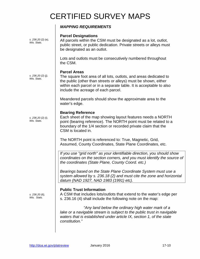
MAPPING REQUIREMENTS Parcel Designations All parcels within the CSM must be designated as a lot, outlot, public street, or public dedication. Private streets or alleys must be designated as an outlot. Lots and outlots must be consecutively numbered throughout the CSM. Parcel Areas The square foot area of all lots, outlots, and areas dedicated to the public (other than streets or alleys) must be shown, either within each parcel or in a separate table. It is acceptable to also include the acreage of each parcel. Meandered parcels should show the approximate area to the water’s edge. Bearing Reference Each sheet of the map showing layout features needs a NORTH point (bearing reference). The NORTH point must be related to a boundary of the 1/4 section or recorded private claim that the CSM is located in. The NORTH point is referenced to: True, Magnetic, Grid, Assumed, County Coordinates, State Plane Coordinates, etc. If you use "grid north" as your identifiable direction, you should show coordinates on the section corners, and you must identify the source of the coordinates (State Plane, County Coord. etc.) Bearings based on the State Plane Coordinate System must use a system allowed by s. 236.18 (2) and must cite the zone and horizontal datum (NAD 1927, NAD 1983 (1991) etc). Public Trust Information A CSM that includes lots/outlots that extend to the water’s edge per s. 236.16 (4) shall include the following note on the map: “Any land below the ordinary high water mark of a lake or a navigable stream is subject to the public trust in navigable waters that is established under article IX, section 1, of the state constitution.”

CERTIFIED SURVEY MAPS
http://doa.wi.gov/platreview January 2016 17-11
s. 236.20 (3) (b), Wis. Stats. s. 236.20 (2) (k), Wis. Stats. s. 236.025, Wis. Stats.
MAPPING REQUIREMENTS Boundary Tie The CSM exterior boundary must be "tied" by length and bearing to the boundary of the 1/4 section or recorded private claim (P.C.) that the CSM is located in. Monuments at both ends of the referenced 1/4 section or recorded P.C. line must be described (material, size, etc); the bearing and distance between the monuments must be shown. Curve Data The following elements must be shown for all curves:
• The radius and central angle • The chord bearing and length • The arc length • The tangent bearing at the PC and PT of each main or
block curve. The curve data may be shown either on the map near the respective curve, or in a Curve Data Table. On the map, the chords of all main curves and block curves are drawn as dashed or dotted lines. Curves with a radius of 30' or less that are used to round off an intersection of two straight lines must be tangent to both lines. For this type of curve, only the radius and tangent lengths for the curve need be shown; all of the curve elements may be shown. Ordinary High Water Mark “Ordinary high water marks” are required to be shown when meander corners and meander lines are established and shown on a plat/map. Surveyors may do one of the following: a) Show an ordinary high water mark on plat/map that has been determined by the DNR or otherwise determined pursuant to law. (b) “Approximate” the ordinary high water mark and show its
location on the plat/map. If a plat/map shows an “approximate” ordinary high water mark, it shall state on the plat/map that the “approximate ordinary high water mark is shown for reference only.”

CERTIFIED SURVEY MAPS s. 236.20 (3) (d & e), Wis. Stats s. 236.34 (1m) (d&e), Wis. Stats [s. 236.21 (1), Wis. Stats.]
MAPPING REQUIREMENTS Abutting lands and streets The platted status of the lands abutting the Certified Survey Map must be shown and underscored in dashed or dotted lines. The boundaries of abutting lands (streets, subdivisions, CSMs) are drawn in dashed or dotted lines in their proper location. Abutting street names are shown and underscored with dashed or dotted lines, and their right-of-way widths are delineated. CERTIFICATES Surveyor’s Certificate A Surveyor’s Certificate must be included on all CSM’s. The certificate must include:
• A description of the lands surveyed, divided, and mapped, by 1/4-1/4 section, section, town, range, and county; or by government lot or recorded private claim. AND
• By metes and bounds, commencing from a USPLS corner (not center of section) of the 1/4 section in which the land lies. OR
• By reference to lots or lots and blocks and subdivision name if land is within a recorded subdivision or recorded CSM that has been previously tied to the monumented line of a ¼ section, GL or PC and shall be described by lot/outlot number and CSM number, and not by metes and bounds.
• The name of the person(s) or entity(s) that directed the
Surveyor to perform the survey, division, and map of the lands described.
• A statement that the map is a correct representation of
the exterior boundary of the land surveyed and the division thereof.
• A statement that the Surveyor has complied with the
requirements of s. 236.34 in surveying, dividing, and mapping the land.
http://doa.wi.gov/platreview December 2014 17-12
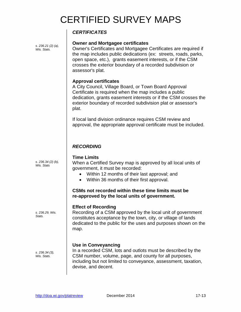
CERTIFIED SURVEY MAPS s. 236.21 (2) (a), Wis. Stats. s. 236.34 (2) (b), Wis. Stats s. 236.29, Wis. Stats. s. 236.34 (3), Wis. Stats.
CERTIFICATES Owner and Mortgagee certificates Owner's Certificates and Mortgagee Certificates are required if the map includes public dedications (ex: streets, roads, parks, open space, etc.), grants easement interests, or if the CSM crosses the exterior boundary of a recorded subdivision or assessor's plat. Approval certificates A City Council, Village Board, or Town Board Approval Certificate is required when the map includes a public dedication, grants easement interests or if the CSM crosses the exterior boundary of recorded subdivision plat or assessor's plat. If local land division ordinance requires CSM review and approval, the appropriate approval certificate must be included. RECORDING Time Limits When a Certified Survey map is approved by all local units of government, it must be recorded:
• Within 12 months of their last approval; and • Within 36 months of their first approval.
CSMs not recorded within these time limits must be re-approved by the local units of government. Effect of Recording Recording of a CSM approved by the local unit of government constitutes acceptance by the town, city, or village of lands dedicated to the public for the uses and purposes shown on the map. Use in Conveyancing In a recorded CSM, lots and outlots must be described by the CSM number, volume, page, and county for all purposes, including but not limited to conveyance, assessment, taxation, devise, and decent.
http://doa.wi.gov/platreview December 2014 17-13

CERTIFIED SURVEY MAPS s. 236.34 (4), Wis. Stats. s. 236.34 (ar) Wis. Stats
VACATION Circuit Court Vacation A CSM, or part of a CSM, may be vacated by the circuit court of the county in which the map is located in the same manner and with like effect as provided in s. 236.40 to 236.44, Wis. Stats. The application may be made by:
• The owner of any lot or outlot in the land that is the subject of the CSM
• The county board if the county has acquired an interest by tax deed
EXPANDED USE OF CSMS A local unit of government may allow more than 4 parcels on a CSM when:
• They have an established planning agency; • A ordinance is enacted or resolution is passed; • A maximum number of parcels is specified; and • Land is zoned commercial, industrial or mixed use.
Requirements for passing an ordinance/resolution:
• Receive recommendation from planning agency; • Hold a public hearing noticed by publishing a class two
notice; and • Enacted ordinance/resolution shall be published in a
form suitable for public distribution.
Such enacted ordinance/resolution by a city or village may be applied to the extraterritorial plat approval jurisdiction area. When local units of government have conflicting requirements for these CSMs, the most restrictive requirements apply.
http://doa.wi.gov/platreview December 2014 17-14
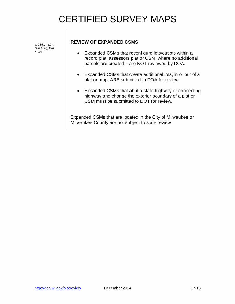
CERTIFIED SURVEY MAPS s. 236.34 (1m) (em & er), Wis. Stats.
REVIEW OF EXPANDED CSMS
• Expanded CSMs that reconfigure lots/outlots within a record plat, assessors plat or CSM, where no additional parcels are created – are NOT reviewed by DOA.
• Expanded CSMs that create additional lots, in or out of a plat or map, ARE submitted to DOA for review.
• Expanded CSMs that abut a state highway or connecting
highway and change the exterior boundary of a plat or CSM must be submitted to DOT for review.
Expanded CSMs that are located in the City of Milwaukee or Milwaukee County are not subject to state review
http://doa.wi.gov/platreview December 2014 17-15

CERTIFIED SURVEY MAPS
Blank Page
http://doa.wi.gov/platreview December 2014 17-16
Wisconsin Certified Survey Map Checklist
http://doa.wi.gov/platreview January 2016 1
(This form is NOT the statute or administrative rule, it is a guide to the statute and rule.)
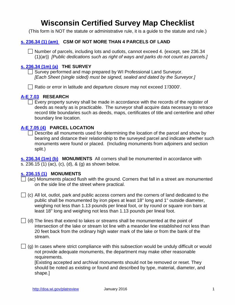
s. 236.34 (1) (am) CSM OF NOT MORE THAN 4 PARCELS OF LAND Number of parcels, including lots and outlots, cannot exceed 4. {except, see 236.34
(1)(ar)} [Public dedications such as right of ways and parks do not count as parcels.] s. 236.34 (1m) (a) THE SURVEY Survey performed and map prepared by WI Professional Land Surveyor. [Each Sheet (single sided) must be signed, sealed and dated by the Surveyor.] Ratio or error in latitude and departure closure may not exceed 1'/3000'. A-E 7.03 RESEARCH Every property survey shall be made in accordance with the records of the register of
deeds as nearly as is practicable. The surveyor shall acquire data necessary to retrace record title boundaries such as deeds, maps, certificates of title and centerline and other boundary line location.
A-E 7.05 (4) PARCEL LOCATION Describe all monuments used for determining the location of the parcel and show by
bearing and distance their relationship to the surveyed parcel and indicate whether such monuments were found or placed. (Including monuments from adjoiners and section split.)
s. 236.34 (1m) (b) MONUMENTS All corners shall be monumented in accordance with s. 236.15 (1) (ac), (c), (d), & (g) as shown below. s. 236.15 (1) MONUMENTS
(ac) Monuments placed flush with the ground. Corners that fall in a street are monumented on the side line of the street where practical.
(c) All lot, outlot, park and public access corners and the corners of land dedicated to the
public shall be monumented by iron pipes at least 18" long and 1" outside diameter, weighing not less than 1.13 pounds per lineal foot, or by round or square iron bars at least 18" long and weighing not less than 1.13 pounds per lineal foot.
(d) The lines that extend to lakes or streams shall be monumented at the point of
intersection of the lake or stream lot line with a meander line established not less than 20 feet back from the ordinary high water mark of the lake or from the bank of the stream.
(g) In cases where strict compliance with this subsection would be unduly difficult or would
not provide adequate monuments, the department may make other reasonable requirements.
[Existing accepted and archival monuments should not be removed or reset. They should be noted as existing or found and described by type, material, diameter, and shape.]

Wisconsin Certified Survey Map Checklist
http://doa.wi.gov/platreview December 2014 2
s. 236.34 (1m) (c) PREPARATION. [cross-referenced to s. 236.20 Wis. Stats. shown below.]
(c) The map shall be prepared in accordance with s. 236.16 (4) and s. 236.20 (2) (a), (b), (c), (e), (f), (g), (h), (i), (j), (k), and (L) and (3)(b), (d), and (e) and must be clearly legible.
[Additional features such as wetlands, buildings and driveways, environmental corridors, and floodplain boundaries may be shown as required by local ordinance.]
At a graphic scale of not more than 500 feet to an inch, which shall be shown on each
sheet showing layout features.
Binding margin 1.5" wide and a 0.5-inch margin on all other sides on durable white paper 8 1/2" wide by 14" long
It must be on durable white media with a nonfading black image.
When more than one sheet is used for any map, each sheet number shall be labeled as
(Sheet 1 of 3 sheets).
"CERTIFIED SURVEY MAP" shall be printed on the map in prominent letters on each sheet with the location of the land by government lot, recorded private claim, quarter-quarter section, section, township, range and county noted.
Seals or signatures reproduced on images complying with this paragraph shall be given
the force and effect of original signatures and seals. s. 236.20 (2) MAP AND ENGINEERING INFORMATION
(a) The exterior boundaries of the land surveyed and divided must be clearly shown. [Use a solid heavy line.]
(b) All monuments erected, corners, and other points established in the field in their proper
places.
The material of which the monuments, corners, or other points are made shall be noted at the representation thereof or by Legend, except interior lot, outlot, and meander corners need not be shown.
The Legend for monuments shall indicate the type, the outside diameter, length, and
weight per lineal foot of the monuments.
(c) The length and bearing of the exterior boundaries, the boundary lines of all blocks, public grounds, streets and alleys, and all lot lines. When the lines in any tier of lots are parallel the bearings of the outer lines on each tier may be sufficient.
Easements not parallel to a boundary or lot line shall be shown by centerline bearing
and width or by easement boundary bearings and distances.
Where easement lines are parallel to boundary or lot lines, the boundary or lot line distances and bearings are controlling.

Wisconsin Certified Survey Map Checklist
http://doa.wi.gov/platreview December 2014 3
s. 236.20 (2) MAP AND ENGINEERING INFORMATION (continued) Where the exterior boundary lines show bearings or lengths which vary from those
recorded in abutting plats or certified surveys, "recorded as" bearings and distances shall be shown.
(e) All lots and outlots must be consecutively numbered.
(f) The exact width of all easements, streets and alleys.
(g) The distances and bearings along all meander lines, and the distance to the ordinary
high water mark at each lot line (must be greater than 20').
(h) The centerline of all streets.
(i) North referenced to a magnetic, true or other identifiable direction. Related to a boundary line of a quarter section, recorded private claim or federal reservation in which the subdivision is located. Include a north arrow on each sheet with details
(j) The areas in square feet of each lot and outlot.
[See 66 OAG 2 (1977) for discussion of lot area calculation involving public and private roads, easements, and navigable water.]
(k) When a street is on a circular curve, the main chords of the right-of-way lines shall be
drawn as dotted or dashed lines in their proper places.
Curves shall show the radius, the central angle, chord bearing, the chord length and the arc length for each segment.
The tangent bearing shall be shown for each end of the main curve.
When a circular curve of 30-foot radius or less is used to round off the intersection
between 2 straight lines, it shall be tangent to both straight lines. It is sufficient to show on the plat the radius of the curve and the tangent distances.
(L) When strict compliance with a provision of this section will entail undue or unnecessary
difficulty or tend to render the plat or certified survey map more difficult to read, and when the information on the plat or certified survey map is sufficient for the exact retracement of the measurements and bearings or other necessary dimensions, the department may waive such strict compliance.

Wisconsin Certified Survey Map Checklist
http://doa.wi.gov/platreview December 2014 4
s. 236.20 (3) LOCATION AND POSITION
(b) The location of the CSM shall be indicated by bearing and distance from a boundary line of a quarter section, recorded private claim or federal reservation in which the subdivision is located.
The monuments at the ends of the boundary line shall be described and the bearing
and distance between them shown.
(d) The names of adjoining streets, state highways and subdivisions shown in their proper location underscored by a dotted or dashed line.
(e) Abutting street and state highway lines of adjoining plats shown in their proper location
by dotted or dashed lines. The width of these streets and highways shall be given also. s. 236.025 (1) ORDINARY HIGH WATER MARKS “Ordinary high water marks” that are required to be shown when meander corners and meander lines are established and shown on a plat/map. Surveyors may do one of the following:
(a) Show an ordinary high water mark on plat/map that has been determined by the DNR or otherwise determined pursuant to law.
(b) “Approximate” the ordinary high water mark and show its location on the plat/map.
s. 236.025 (3) ORDINARY HIGH WATER MARKS If a plat/map shows an “approximate” ordinary high water mark, it shall state on the plat/map that the “approximate ordinary high water mark is shown for reference only.” s. 236.20 (6) PUBLIC TRUST INFORMATION
A CSM that includes lots/outlots that extend to the water’s edge per s. 236.16 (4) shall include the following note on the drawing:
“Any land below the ordinary high water mark of a lake or a navigable stream is subject
to the public trust in navigable waters that is established under article IX, section 1, of the state constitution.”
A-E 7.08 U.S. PUBLIC LAND SURVEY MONUMENT RECORD.
(1) A U.S. public survey monument shall be prepared and filed with the county surveyor’s office as part of any land survey which includes or requires the perpetuation, restoration, reestablishment or use of a U.S. public land survey corner, and,
(a) There is no U.S. public land survey monument record for the corner on file with the
county surveyor; or
Wisconsin Certified Survey Map Checklist
http://doa.wi.gov/platreview December 2014 5
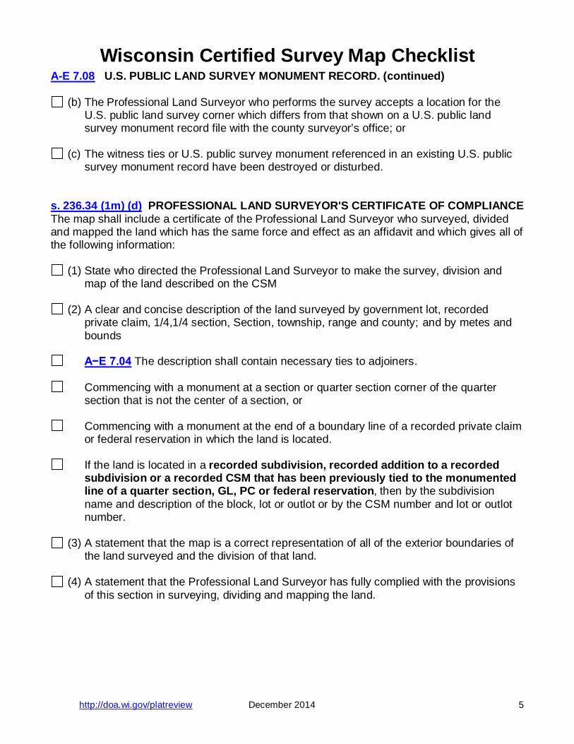
A-E 7.08 U.S. PUBLIC LAND SURVEY MONUMENT RECORD. (continued)
(b) The Professional Land Surveyor who performs the survey accepts a location for the U.S. public land survey corner which differs from that shown on a U.S. public land survey monument record file with the county surveyor’s office; or
(c) The witness ties or U.S. public survey monument referenced in an existing U.S. public
survey monument record have been destroyed or disturbed. s. 236.34 (1m) (d) PROFESSIONAL LAND SURVEYOR'S CERTIFICATE OF COMPLIANCE The map shall include a certificate of the Professional Land Surveyor who surveyed, divided and mapped the land which has the same force and effect as an affidavit and which gives all of the following information:
(1) State who directed the Professional Land Surveyor to make the survey, division and map of the land described on the CSM
(2) A clear and concise description of the land surveyed by government lot, recorded
private claim, 1/4,1/4 section, Section, township, range and county; and by metes and bounds
A−E 7.04 The description shall contain necessary ties to adjoiners.
Commencing with a monument at a section or quarter section corner of the quarter
section that is not the center of a section, or
Commencing with a monument at the end of a boundary line of a recorded private claim or federal reservation in which the land is located.
If the land is located in a recorded subdivision, recorded addition to a recorded
subdivision or a recorded CSM that has been previously tied to the monumented line of a quarter section, GL, PC or federal reservation, then by the subdivision name and description of the block, lot or outlot or by the CSM number and lot or outlot number.
(3) A statement that the map is a correct representation of all of the exterior boundaries of
the land surveyed and the division of that land.
(4) A statement that the Professional Land Surveyor has fully complied with the provisions of this section in surveying, dividing and mapping the land.
Wisconsin Certified Survey Map Checklist
http://doa.wi.gov/platreview December 2014 6
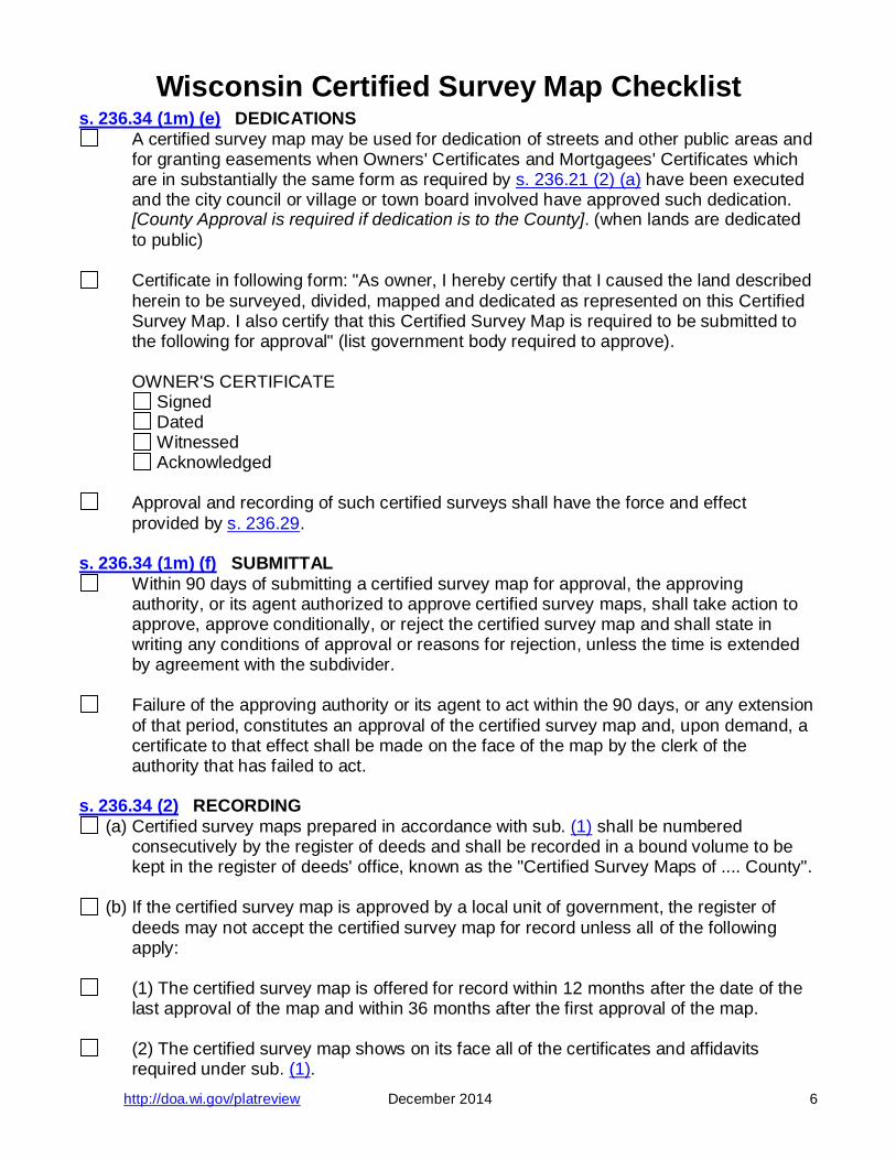
s. 236.34 (1m) (e) DEDICATIONS A certified survey map may be used for dedication of streets and other public areas and
for granting easements when Owners' Certificates and Mortgagees' Certificates which are in substantially the same form as required by s. 236.21 (2) (a) have been executed and the city council or village or town board involved have approved such dedication. [County Approval is required if dedication is to the County]. (when lands are dedicated to public)
Certificate in following form: "As owner, I hereby certify that I caused the land described
herein to be surveyed, divided, mapped and dedicated as represented on this Certified Survey Map. I also certify that this Certified Survey Map is required to be submitted to the following for approval" (list government body required to approve).
OWNER'S CERTIFICATE Signed Dated Witnessed Acknowledged
Approval and recording of such certified surveys shall have the force and effect provided by s. 236.29.
s. 236.34 (1m) (f) SUBMITTAL
Within 90 days of submitting a certified survey map for approval, the approving authority, or its agent authorized to approve certified survey maps, shall take action to approve, approve conditionally, or reject the certified survey map and shall state in writing any conditions of approval or reasons for rejection, unless the time is extended by agreement with the subdivider.
Failure of the approving authority or its agent to act within the 90 days, or any extension
of that period, constitutes an approval of the certified survey map and, upon demand, a certificate to that effect shall be made on the face of the map by the clerk of the authority that has failed to act.
s. 236.34 (2) RECORDING
(a) Certified survey maps prepared in accordance with sub. (1) shall be numbered consecutively by the register of deeds and shall be recorded in a bound volume to be kept in the register of deeds' office, known as the "Certified Survey Maps of .... County".
(b) If the certified survey map is approved by a local unit of government, the register of
deeds may not accept the certified survey map for record unless all of the following apply:
(1) The certified survey map is offered for record within 12 months after the date of the
last approval of the map and within 36 months after the first approval of the map.
(2) The certified survey map shows on its face all of the certificates and affidavits required under sub. (1).
Wisconsin Certified Survey Map Checklist
http://doa.wi.gov/platreview December 2014 7
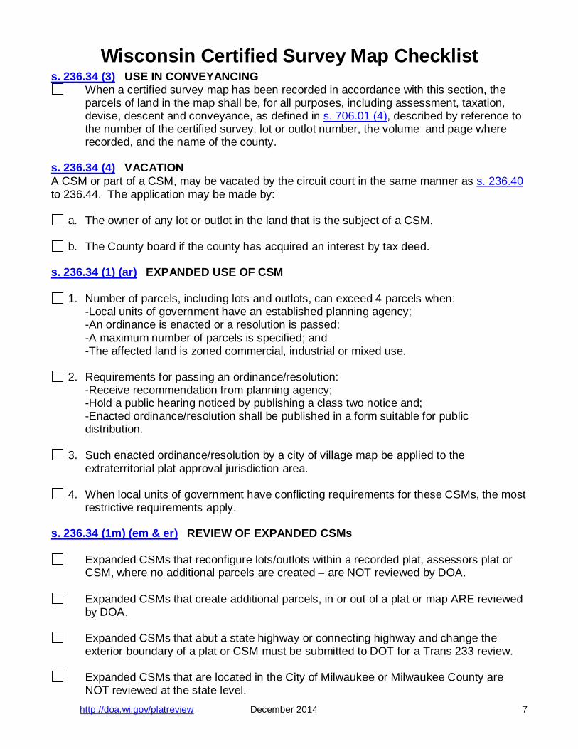
s. 236.34 (3) USE IN CONVEYANCING When a certified survey map has been recorded in accordance with this section, the
parcels of land in the map shall be, for all purposes, including assessment, taxation, devise, descent and conveyance, as defined in s. 706.01 (4), described by reference to the number of the certified survey, lot or outlot number, the volume and page where recorded, and the name of the county.
s. 236.34 (4) VACATION A CSM or part of a CSM, may be vacated by the circuit court in the same manner as s. 236.40 to 236.44. The application may be made by:
a. The owner of any lot or outlot in the land that is the subject of a CSM.
b. The County board if the county has acquired an interest by tax deed. s. 236.34 (1) (ar) EXPANDED USE OF CSM
1. Number of parcels, including lots and outlots, can exceed 4 parcels when: -Local units of government have an established planning agency; -An ordinance is enacted or a resolution is passed; -A maximum number of parcels is specified; and -The affected land is zoned commercial, industrial or mixed use.
2. Requirements for passing an ordinance/resolution: -Receive recommendation from planning agency; -Hold a public hearing noticed by publishing a class two notice and; -Enacted ordinance/resolution shall be published in a form suitable for public
distribution.
3. Such enacted ordinance/resolution by a city of village map be applied to the extraterritorial plat approval jurisdiction area.
4. When local units of government have conflicting requirements for these CSMs, the most
restrictive requirements apply. s. 236.34 (1m) (em & er) REVIEW OF EXPANDED CSMs
Expanded CSMs that reconfigure lots/outlots within a recorded plat, assessors plat or CSM, where no additional parcels are created – are NOT reviewed by DOA.
Expanded CSMs that create additional parcels, in or out of a plat or map ARE reviewed
by DOA.
Expanded CSMs that abut a state highway or connecting highway and change the exterior boundary of a plat or CSM must be submitted to DOT for a Trans 233 review.
Expanded CSMs that are located in the City of Milwaukee or Milwaukee County are
NOT reviewed at the state level.

CERTIFIED SURVEY MAPS
Blank Page
http://doa.wi.gov/platreview December 2014 17-24
CERTIFIED SURVEY MAPS
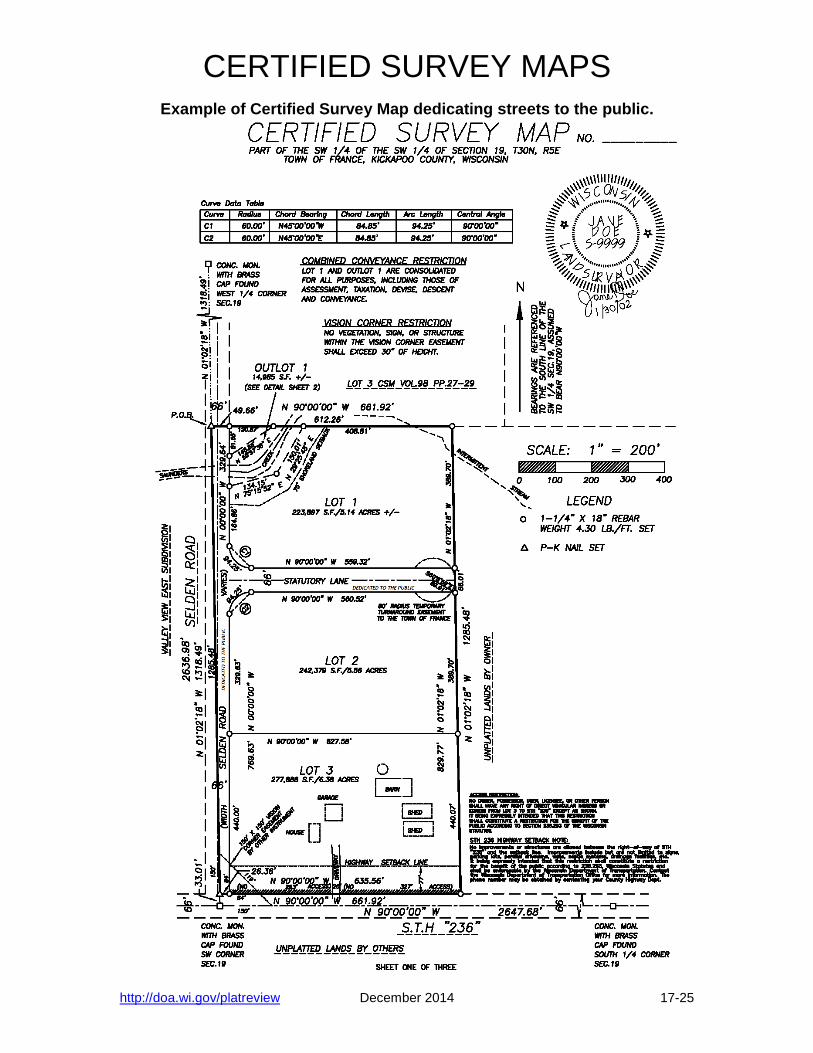
Example of Certified Survey Map dedicating streets to the public.
http://doa.wi.gov/platreview December 2014 17-25
CERTIFIED SURVEY MAPS
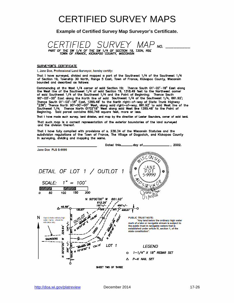
Example of Certified Survey Map Surveyor’s Certificate.
http://doa.wi.gov/platreview December 2014 17-26

CERTIFIED SURVEY MAPS
Example of Certified Survey Map Owner’s and Approval Certificates required when dedicating lands.
http://doa.wi.gov/platreview December 2014 17-27
CERTIFIED SURVEY MAPS
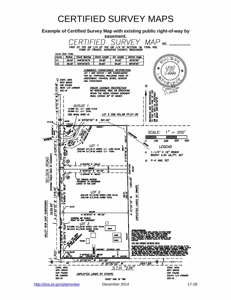
Example of Certified Survey Map with existing public right-of-way by easement.
http://doa.wi.gov/platreview December 2014 17-28